Facoltà di Scienze Matematiche Fisiche e Naturali
Dottorato in Geodinamica
Ciclo XXI
D
EFORMATION PROCESSES ALONG THE
C
ALABRIAN COMPRESSIVE MARGIN
Liliana Minelli
Relatore: Prof. Claudio Faccenna
Coordinatore: Prof. Domenico Cosentino
Correlatore: Dott. Piero Casero
Revisori: Prof. Stefano Mazzoli,
Prof. François Roure
Preface CHAPTER 1 Structure and evolution of the Calabrian accretionary prism 1. Introduction 1 2. Introduction to Mediterranean geodynamic 2 3. Geological setting of the Calabrian accretionary wedge and Ionian offshore: previous works 3 4. Seismic dataset 7 5. Seismic stratigraphy 7 6. Structure of the Calabrian accretionary wedge 12 6.1 Western margin 12 6.2 Eastern margin 15 6.3 Calabrian accretionary wedge 18 6.3.1 Crotone – Spartivento forearc basin 19 6.3.2 Inner accretionary wedge 23 6.3.3 Frontal ramp and outer accretionary wedge 24 6.3.4 Foreland basin and intra‐plate deformation zone 25 7. Discussion 28 7.1 Discussion on intraplate deformation (Ionian abyssal plain) 28 7.2 Discussion on the boundary of the Calabrian accretionary prism 29 7.2.1 Western boundary of the Calabrian accretionary prism 29 7.2.2 Eastern boundary of the Calabrian accretionary prism 30 7.3.3 Outer front of the Calabrian accretionary prism 30 7.3 Discussion about the outer accretionary prism 31 8. Time – space evolution of the Calabrian accretionary prism 34 8.1 Wedge detaching on salt 37 8.2 Final model 39 9. Conclusion 45 References 46
Abstract 56 1. Introduction 56 2. Geological Overview of the Calabria‐Peloritani Arc 58 2.1 Geochronological and Stratigraphic constraints 59 2.2 Geological setting of the eastern Sila Massif 62 3. Structural geology of the eastern Sila Massif 63 3.1 Onshore structural analysis 63 3.2 From onshore to offshore 69 4. Apatite Fission Track Thermochronology 71 4.1 Method 71 4.2 Results and interpretation 73 5. Discussion 76 6. Dynamic of the Calabrian accretionary complex 77 7. Conclusion 79 References 79 CHAPTER 3 Processes instability along an active margin from two case‐history Introduction 86 Messina Tsunami Abstract 87 1. Introduction 87 2. Brief Seismotectonic setting 87 3. Methods and Results 88 4. Discussion and Conclusion 95 References 96
1. Introduction 99 2. Geological setting 99 3. Stratigraphic setting 101 4. Well data 103 5. Seismic data 105 6. Discussion 107 7. Conclusion 110 References 110
INTRODUCTION
The Calabrian arc is a fundamental area to understand the tectonic evolution of the Apennine and Maghrebian fold‐and‐thrust belts within the framework of convergence between African and Eurasian plates in the central Mediterranean. The Calabrian arc has been the subject of several studies since at least the 1950s by geological and geophysical methods. Despite the large amount of collected data, geometry, kinematics, and tectonic evolution of the Calabrian accretionary prism are still poorly defined, particularly in the offshore region. Understanding the structure of the Calabrian accretionary prism bears important implications in the mitigation of hazards connected with the active tectonics of this region, particularly in marine environments.
This thesis addresses the tectonics of the Calabrian convergent margin by using mainly offshore seismic reflection profiles spread over the entire Ionian Sea, in the central Mediterranean. In particular, geometry, kinematics, and time‐space evolution of the Calabrian accretionary prism are studied and defined. In one case (Longobucco area, northern Calabria), we integrated structural, geological and thermo‐chronological analyses to define the oldest phases of accretion and growth of the Calabrian accretionary prism. Eventually, implications for the mitigation of natural hazards typical of active, or recently‐active, convergent margins are considered. In particular, we analyzed two significant case histories: the Crotone megalandslides, which is a presently active margin spreading above a thick Messinian salt layer at very low rates; and the 1908 Messina tsunami possibly triggered by a large landslide which occurred off the Ionian coast of Sicily along the steep Malta Escarpment.
Although several new or old questions remain open, results from this thesis shed new light on the tectonic evolution of the Calabrian accretionary prism and related subduction processes. For the first time, new industrial data have been interpreted and combined with previously published geophysical and geological dataset, to provide a complete view of this tectonically complex region.
1
1. Introduction
The Neogene tectonics of the Central Mediterranean is connected with the subduction of the Ionian basin under Eurasia and has been mainly dominated by trench rollback, which produced the opening of the Liguro‐ Provencal and Tyrrhenian back‐arc basins and the formation of Calabrian accretionary wedge.
The Calabrian accretionary wedge is a partially submerged south‐verging accretionary prism, which extends from South Calabria to the Ionian abyssal plain and, laterally, from the Malta escarpment, to the West, to the Apulia escarpment and Mediterranean Ridge, to the East. The wedge consists of a pile of deformed sediments involved in the convergent setting between Europe and Africa.
Despite the Ionian basin has been investigated in the last forty years by conducting several geological and geophysical surveys, results from these studies are often controversial and, consequently, the structure of the wedge is still poorly defined. In this thesis, results from a study based on the interpretation of seismic reflection profiles acquired since the end of the 1960’s onward in the Ionian offshore by industrial exploration and academic cruises are presented. The main purpose of this thesis is to provide a synthetic outline of the structural setting of the Ionian offshore and, in particular, to define the style and timing of deformations of the Calabrian accretionary complex. To do so, seismic reflection profiles from the Ionian offshore have been collected and interpreted. These data have been combined with other geological and geophysical data from offshore and onshore areas. The huge amount of available data here favors a more complete study with respect to the previous ones. These data allow to identify and to map out the main structures that characterized the Ionian offshore. The aim of this study is then twofold: (1) to describe the structural style of the Calabrian accretionary wedge and (2) to define the evolution of this key‐area of the central Mediterranean.
The Calabrian subduction zone represents an anomalous (analogously to the Mediterranean Ridge) low tapered accretionary complex characterized by the absence of trench‐like feature and of clear outer deformation front.
The limits of this work arise from the paucity of direct geological constraints for the inner sector of the wedge and for the deeper part of the Ionian offshore. Most conclusions are based on lateral correlations and supported by interpretation provided in previous studies. For this reason, the discussion is mainly based on a key seismic reflection marker, which allows us to describe the structure of the wedge in terms of pre‐, syn‐, and post‐Messinian deformation. All reconstructions of structural and stratigraphic conditions are mainly based on seismic explorations and on a large amount of data available from the oil industry. Further limits derive from the age and quality of the available seismic profiles, and from the lack of high resolution data.
2
2. Introduction to Mediterranean geodynamic
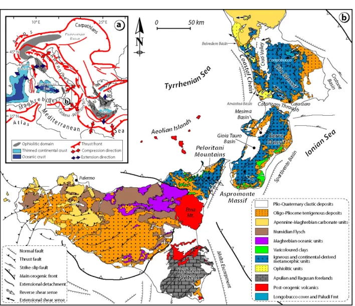
The evolution of this portion of the Eurasia‐Africa plate boundary over Neogene‐Quaternary times is generally interpreted in terms of slow relative plate convergence (Argus et al., 1989; De Mets et al., 1994), subduction of the Ionian lithosphere beneath the Calabrian arc, fast slab rollback and associated back‐arc spreading in the Tyrrhenian Sea (Malinverno & Ryan, 1986; Patacca et al., 1990; Faccenna et al., 2001 a). The present‐day Ionian basin is shaped by the progressive subduction of the deep Ionian basin beneath the Calabrian arc. Subduction of this relic of the Neo‐Tethys ocean and the progressive rollback of the slab during Neogene times has produced the opening of two back‐arc basins and has resulted in the growth of a large sedimentary Calabrian accretionary wedge (Fig.1). Tomographic images (Selvaggi and Chiarabba, 1995; Mele, 1998; Lucente et al., 1999; Piromallo and Morelli, 2003; Wortel and Spakman, 2000; Montuori et al., 2007) show, under the Calabrian subduction zone, a northwestward dipping slab, which is affected by a 150 km‐wide window beneath the southern Apennines. This window opened after a tear occurring within a composite subduction system, formed by the Apulian continental lithosphere and the Ionian oceanic slab (Chiarabba et al., 2008). Figure 1 ‐ (a) Synthetic tectonic map of the Tyrrhenian‐Apennines system in the framework of the central Mediterranean region (modified after Jolivet et al., 1998). (b) Geological sketch map of the Calabria‐Peloritani Arc.
The crustal thickness, reconstructed by refraction OBS (ocean bottom seismometers) and ESP (expanding spread profiles) surveys, shows a progressive thickening from the Ionian abyssal plain to the Calabrian arc, as previously suggested by Hinz et al. (1974). In particular, the crust under the Ionian abyssal plain is between 11
3
to 17 km in thickness (Makris et al., 1986; de Voogd et al., 1992) and increases to more than 30 km near the Calabrian coast (Ferrucci et al., 1991; Cernobori et al., 1996).
Direct seismological and geological evidence of the present‐day subduction activity in terms of shortening in the accretionary wedge and spreading in the Tyrrhenian back‐arc basin are lacking. Presently, earthquakes are distributed along the Wadati‐Benioff zone well delineating the steeply (70°) dipping Ionian lithosphere beneath the Calabrian Arc (Selvaggi e Chiarabba, 1995). 3. Geological setting of the Calabrian accretionary wedge and Ionian offshore: previous works The Calabrian accretionary prism is a curved submerged fold and thrust belt originated by the northwestward subduction of the Ionian lithosphere beneath the Calabrian arc and by the southeastward retreat of the slab since late Oligocene to present times (Réhault et alii, 1986; Malinverno & Ryan, 1986; Ricci Lucchi, 1986; Patacca & Scandone, 1989; Boccaletti et alii, 1990; Gueguen et alii, 1998). The prism, located in the Ionian offshore, is bounded to the East by the Apulia Escarpment and by the advancing Mediterranean Ridge, and, to the West by the Malta Escarpment. Towards the South, the Ionian abyssal plain, a flat deep basin of triangular shape, represents the present foreland basin.
Several geophysical surveys have been performed in the Ionian offshore. Seismic reflection (Rossi and Borsetti, 1974; Finetti 1982, 1985; Cernobori et al., 1996; Catalano et al., 2000, 2001; Hirn et al., 1997) and refraction surveys (Makris et al., 1986; Ferrucci et al., 1991; de Voogd et al., 1992; Truffert et al., 1993), dredging and sampling (Rossi and Borsetti, 1974; Scandone et al., 1981; Fabbri et al., 1982; Barbieri et al., 1982; Casero et al., 1984), heat flow measurements (Della Vedova & Pellis, 1992), magnetic (Aris Rota & Fichera, 1985) and gravimetric (Morelli et al., 1975) surveys produced a wealth of data for the interpretation of this area. However, the seismic grid of the previously published works on the Ionian offshore is still loosely spaced and, therefore, both attitude and extent of faults are still poorly constrained.
Main open questions on the tectonics of the Ionian region concern the nature of the Ionian lithosphere, the recent tectonic evolution of the prism, the extent and structure of the Calabrian accretionary wedge, the timing of deformations, and the modalities of interference with the other tectonic elements (Mediterranean Ridge and Southern Apennines) are still debated.
The Ionian subducting lithosphere has been considered as entirely oceanic with the exception of the Ionian abyssal plain, which is interpreted either as an oceanic relict of the Tethys (BijuDuval et al., 1977; Finetti, 1982; Makris et al., 1986; De Voogd et al., 1992; Truffert et al., 1993; Finetti et al., 1996; Finetti and Del Ben, 2000; Catalano et al., 2001) or as a foundered stretching continental crust connecting the African margin with Apulia and southern Sicily (Hinz 1974; Boccaletti et al., 1984; Cernobori et al., 1986; Ismail‐Zadeh et al., 1998; Nicolich
4
et al., 2000; Hieke et al., 2003). Seismic data reveals that the sedimentary cover of the Ionian basin is about 6 ‐ 8 km thick and consists of Mesozoic‐Cenozoic pelagic sediments, deep‐sea siliciclastic turbidites, and a thick Messinian evaporitic layer (Finetti, 1982; Makris et al., 1986; Ferrucci et al., 1991; de Voogd et al., 1992; Truffert et al., 1993).
Moreover, the Ionian basin is characterized by a positive Bouguer anomaly (310 mGal), which is probably related to mantle density anomalies, by the absence of magnetic anomalies typical of oceanic crust, and by a low heat flux (40 mW/m2). Any geological solution for the Ionian region should then consider that: a) the abyssal plain is 4 km deep, thus requiring a density profile closer to oceanic lithosphere, and b) the crustal thickness is about 12 km.
Previous authors describe the structural setting of the Calabrian accretionary wedge by using seismic reflection profiles (Rossi and Sartori, 1981; Barone et al., 1982; Finetti, 1982; Cernobori et al., 1996; Sioni, 1996). Rossi and Sartori (1981) first divided the accretionary prism in several sectors: i) the Crotone‐Spartivento basin, ii) the inner transition zone, iii) the ECA (External Calabrian Arc) and an outer zone (Calabria Ridge s.l.) where gravity and salt are considered as mainly driving deformation process (Rossi and Sartori, 1981; Chamot‐Rooke et al., 2005). Similarly, Sioni (1996) (Prismed multichannel survey PM01), moving from NW to SE, recognised the following domains: the Crotone‐Spartivento basin, the Calabrian arc, the Messina cone, the Ionian abyssal plain, and the Syrte basin (Fig. 2). Figure 2 – Summary of nomenclature used for describe the main structure of the Calabrian accretionary prism in the previous works (Rossi and Sartori, 1981; Finetti, 1982; Sioni, 1996) and that proposed in this work (Minelli, 2008). Cernobori et al. (1996) show (1) progressive landward thickening of deformed sedimentary piles resting upon less deformed sediments, (2) the presence of a décollement level detected at the interface between accreted and subducting sequences, and (3) important shortening expressed by reverse faulting, folding and thrusting. They show also the contact between the Sila crystalline backstop and the Calabrian accretionary wedge (Fig. 3). Finetti (1982) outlines a complete section of the Calabrian Arc from the undeformed area of the Ionian abyssal
5
plain up to the area deformed by Neogene‐Quaternary compressional structure. In the outer domain of the Calabrian Arc, the basal décollement corresponds to the base of Messinian evaporite and progressively deepens by involving the entire sedimentary succession (i.e., Tertiary and Upper Mesozoic). Moreover the outer part of the arc is characterized by frontal sliding allochthonous or mélange complexes. Main questions about the prism thus concern the nature of the outer wedge zone and the recent‐Neogene activity of the accretionary prism.
Figure 3 – (a) Location map of the STREAMERS profiles in western Ionian Sea and (b) linedrawing of the Calabrian accretionary prism, by Cernobori et al. (1996)
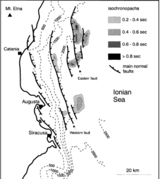
The western boundary of the Calabrian accretionary wedge has been extensively surveyed during several cruises. The main feature of the area is represented by the Malta Escarpment, a NNW‐SSE trending, 250 km long structure extending from the eastern margin of Sicily to the Medina Mounts in the Ionian abyssal plain. The Malta Escarpment links the Hyblean continental plateau, to the West, to the Ionian abyssal plain and Calabrian accretionary prism, to the East. Despite its prominent structure, it cannot be considered as an oceanic‐continental boundary. Indeed, the age of the escarpment is probably Tortonian (Makris et al., 1986) to post‐Tortonian (Scandone et al., 1981; Casero et al., 1984; Sartori et al., 1991) and developed by re‐activating a Mesozoic crustal‐scale structure. The stratigraphic succession that forms the substratum of the escarpment probably extends from late Triassic to Miocene as attested by sampling along the escarpment (Biju‐Duval et al., 1982; Casero et al., 1984) and on the Alfeo seamount (Rossi and Borsetti, 1974). Along the escarpment, magmatic activity has been registered by magnetic anomalies (Morelli et al., 1975) and basalts samples (Scandone et al., 1981; Biju‐Duval et al., 1982). Several NNW‐SSE striking, east dipping, extensional/strike slip faults have been described along the northern offshore of Sicily, with evidences of recent activity as testified by Plio‐Quaternary synrift deposits (Rossi and Borsetti, 1974; Cernobori et al., 1996; Hirn et al., 1997; Bianca et al., 1999; Adam et al., 2000; Nicolich et al., 2000; Argnani et al. 2002; Argnani and Bonazzi, 2005) (Fig.4). Argnani et al. (2002) also describe compressional
6 deformation inverting some recent normal faults. Toward the south the Malta Escarpment is not affected by recent faulting but flattens out toward the Ionian basin (Argnani et al., 2002). The eastern margin of the Calabrian accretionary wedge is located between the Italian coasts of Calabria and Puglia and extends toward the southeast as far as the Cephalonia Island. This area is characterized by the presence of the Apulian platform that extends over the Apulian region and, probably, over the Straits of Otranto up to the Greek islands of Zante and Cephalonia, where the platform abruptly terminates against the Cephalonia transform fault. The southward extension of the platform is not obvious. According to geophysical data, industrial wells, and submersible observations, the platform reaches the Cephalonia Fault and is abruptly truncated and displaced to the southwest. The Apulian Escarpment, the southwestern boundary of the Apulian platform is a recessive erosional boundary which developed during the Messinian lowstand (Bosellini, 2002). It separates the Apulian ridge to the East from the Ionian abyssal plain to the West. The Apulian platform bent and flexed both beneath the Hellenides, to the East, and beneath the Southern Apennines thrust belts, to the West. The Apulian ridge, which is the submerged offshore prolongation of the Apulian platform, represents the weakly deformed foreland basin and is presently buried below the Pliocene Apenninic foredeep (Central Adriatic basin, Bradanic Valley basin, Taranto Valley) related to the east‐verging Apenninic thrust belt and under the Mio‐Pliocene foredeep to the East (South Adriatic basin) which are related to the Hellenic and Dinaric thrusts belt.
Several geophysical (seismic reflection survey) and geological data (industrial wells, and sample, and dredge) have been collected in this area (Finetti and Morelli, 1973; Rossi and Borsetti, 1974; Finetti, 1976; Rossi et al.,
Figure 4 – Structural sketch map of the Ionian offshore zone of eastern Sicily derived from the analysis of seismic reflection profiles. Isochronopachs of the synrift basins developed along the hanging wall of the major normal fault segments (Bianca et al., 1999).
7 1983; Doglioni, 1999). The Apulian carbonate platform consists of a continental crust with Mesozoic (Jurassic‐ Cretaceous) shallow water carbonates, which are about 7000 m thick (2 s TWT) (Mostardini and Merlini, 1986) and a thin sequence of Tertiary calcarenites and limestone. The lithology is confirmed by the onshore drilling and dredge offshore along the main escarpment. In places, the Messinian horizon lies on top of the carbonatic basement or on a sequence of Miocene age (Rossi and Borsetti, 1974). On top of these units, also a sequence of marls and clay of Pliocene‐Pleistocene age has been recovered by dredges along the Apulia escarpment. 4. Seismic dataset Fig. 5 shows the location of the principal data used in this work. Data include multichannel seismic reflection profiles acquired in the Ionian Sea since the end of 1960’s (i.e., Italian Commercial Zone ”F” and Zone “D” lines, Mediterranean Sea “MS” lines by OGS, Calabrian Arc data supplied courtesy of Fugro, ION Streamers profiles, CROP seismic reflection profiles of the Italian crust sponsored by ENEL, ENI and CNR, PM01 of MCS Prismed survey and ARC of Archimede academic cruise managed by Ecole Normale Supérieure team).
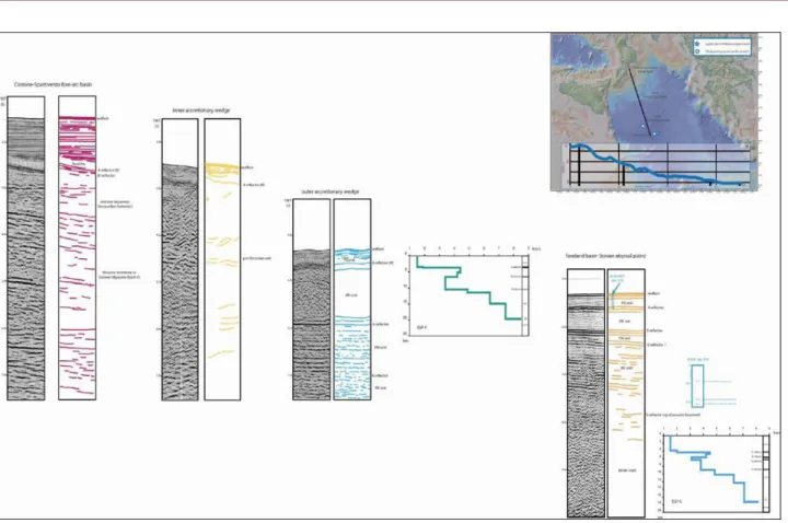
The resolution and the quality of the seismic profiles remarkably vary due to different acquisition parameters and energy systems used during different surveys. Data from some hydrocarbon boreholes are also available near the Calabrian and Sicily coasts and have been used to calibrate the seismic data. We have also used all geophysical and geological data (ESP refraction data, dredged and gravity or piston core, Ocean Drilling Program (ODP) and Deep Sea Drilling Project (DSDP) ) available for the Ionian offshore to better define the stratigraphic succession of the incoming subducting sediments. The recognition along several seismic profiles of the main reflection horizons and of their geological attributes allowed us to date the activity of the main thrust systems in the Calabrian accretionary prism. Furthermore, the high‐density grid of the seismic lines allowed us to map out the main structural features and to reconstruct the evolution of the accretionary processes in the Ionian offshore. In this thesis, seismic profiles are presented as line‐drawing distance against reflection time (TWT = two‐way travel time), and thickness variations are expressed in millisecond (ms) TWT. 5. Seismic stratigraphy For the seismic interpretation of the entire dataset in the Ionian offshore, starting from the reliable data on the less deformed foreland basin, the Ionian abyssal plain, it is possible to extend the interpretation of the main reflectors to the complex internal parts of the wedge. Fig. 6 shows the acoustic stratigraphy of four
8
sedimentary sections along a NW‐SE profile crossing the Calabrian accretionary wedge from the Crotone‐ Spartivento basin to the foreland basin.
Figure 5 ‐ Location map of seismic reflection profiles across the Calabrian accretionary prism in the Ionian offshore (Eastern Mediterranean Sea), wells and geophysical data. Solid lines, with a color‐coded according to their source, indicate the multichannel seismic profiles using in this work. The stars indicate the position of DSDP (Hsu et al., 1978) and squares of the ODP drilling (Emeis et al., 1996). Violet dots indicate the locations of the wells available by oil industry. Diamond indicate the location of the ESPs profile (de Voogd et al., 1992). Triangles and yellow lines indicate dredge samples and gravity or piston core (Rossi e Borsetti, 1974; Scandone et al., 1981; Morlotti et al., 1982; Bizon et al., 1983; Casero et al., 1984; Sartori et al., 1991; Hieke et al., 2006). In the Ionian basin, a few main reflectors are recognized. For their marked continuity and strong signal, these reflectors are already known in the entire Mediterranean region (Ryan et al., 1978; Finetti and Morelli, 1973; Casero et al., 1984; Reston et al., 2002; Polonia et al., 2002; Hieke et al., 2003). These data were used in the
9
calibration together with existing data produced by the oil exploration activity near the Calabria and Sicily shore.
In the Ionian offshore, a typical example of good reflectivity of the sequence comes from the foreland region, where these reflectors are undisturbed and has been also calibrated by ESP refraction data (De Voogd et al., 1992) and by DSDP (site 374 Messina) drilling. Five main seismo‐stratigraphic units (PQ, ME, PM, MC and acoustic basement) separated by regional reflectors (A, B, K and S) have been detected in the Ionian abyssal plain.
horizon A: base of Plio‐Quaternary sediment (PQ unit) or top of the evaporite (also named as M‐reflectors
(Ryan, 1969)). The A reflector, a strong high amplitude reflector, is almost continuous in the whole basin and it corresponds to the top of Messinian sequences. it is easily identified because of its typical seismic signature. However, in regions where the evaporites are absent, the hiatus is still marked by a regionally continuous and strong M‐reflector that delineates a prominent angular unconformity at the base of the Pliocene‐Quaternary succession. Therefore, because the M reflector is time‐transgressive and it does not always represent the top of the Messinian, it can be better considered as the base of the PQ unit. This interpretation implies that M– reflector does not indicate the presence or not of Messinian evaporite. horizon B: base of Messinian (evaporite and terrigenous unit ME) sequence. This horizon is attributed to the base of evaporites because it represents the first flat reflector below the interval, where diapiric structures are evident (Finetti and Morelli, 1973). While the Plio‐Quaternary sequences and top of Messinian evaporites were drilled (DSDP site 374), no direct well drill was operated through the pre‐Messinian sequences. Geological correlation, previous works in other regions, and seismic velocities have been used so far to interpret these sequences. horizon K: top of Mesozoic sequences (unit MC) possibly constituted by carbonate series or lower boundary of the Tertiary clastic sequence (unit PM). horizon S: top of the acoustic basement. In the foreland, this horizon lies at about 8 s (TWT) and it has been interpreted as the upper layer of oceanic crust (layer 2a) in agreement with de Voogd et al., (1992). PQ unit: consists of sub‐parallel, high‐frequency, low amplitude reflectors, consistent with terrigenous deposits characterized by an average thickness of 200‐400 ms TWT in the entire Ionian offshore except for the Crotone‐Spartivento basin, where it reaches the maximum thickness of 2 s TWT. In the Ionian abyssal plain, the sequence is almost undeformed, whereas in the internal sector of the wedge, it is strongly deformed. In the forearc basin, the PQ unit is affected by normal faults (syn‐ or post‐sedimentary) and involved in salt tectonics documented by diapiric structures. The lower boundary of these upper sediments is defined by strong reflectors interpreted as the top of the Messinian evaporitic sequence.
10
ME unit: consists of evaporitic and clastic sediments of Messinian age. The top is marked by the A (or M)
reflectors and the base by the B reflectors, which are planar, continuous and high amplitude reflectors. In the foreland basin, this unit has an average thickness of 0.4 s TWT, this thickness being probably the original thickness formed in the basin. The seismic profiles show a gradual thickening of the Messinian unit toward the prism. The Messinian sediments are, in fact, progressively incorporated in the Calabrian front of deformation. In the internal sector of the prism, salt layers are present in places as attested by diapiric structures and typical deformational features of salt tectonics. In the foreland basin, the ME unit consists of, as documented by ESP refraction data, an upper part identified by high velocity and related to the upper evaporitic layer, and a lower part less reflective related to the Messinian clastic sequence.
PM unit: sequence poorly reflective, well layered, consistent whit deep water clastic and marls Tertiary
terrigenous sediments (Ryan et al., 1973; Hsu et al., 1978). This unit is deformed under the Ionian basin and its thickness varies from 1.5 s TWT to 0.4 s TWT. In the frontal part of the wedge, this unit represents the subducting sediment. Moving landward, the sediments are progressively incorporated into the Calabrian prism. The lower boundary, K reflectors, marks the transition to the Mesozoic carbonate series. MC unit: is characterized by strong, relatively continuous, and low frequency reflections, consistent with the presence of Mesozoic carbonates. The average thickness is 1.5 s TWT. These sequences are subducted beneath the Calabrian prism. Acoustic basement: in the foreland basin, the acoustic basement is characterized by reflective sequence that shows an increasing velocity with depth. Fig. 6 shows also as in the inner sector of the prism the internal deformation obscures the main horizons.
11
Figure 6 ‐ Seismic stratigraphy and line drawing of the incoming sedimentary section in the Ionian offshore. The four column are aligned along a general NW‐SE cross section through the Calabrian accretionary prism from the Crotone‐ Spartivento basin (a), to the foreland basin, Ionian abyssal plain (d). Vertical scale in two‐way traveltime, TWT (s). The main reflector labels A, B, K and S, as defined by Finetti and Morelli (1973), have been used to distinguish the different seismic unit. According to Finetti and Morelli (1973), these reflections may represent: A base of Plio‐Quaternary sequences (A reflector also identified as the M reflector), B base of Messinian evaporitic sequences, K transition between Cenozoic and Mesozoic sediment, probably top of carbonate series, S top of the acoustic basement . The seismic lines, where it was possible, has been calibrated using velocity data ESP (de Voogd et al., 1992) and hole (site 374) drilled during Leg 13 of DSDP (Hsü et al., 1978).
a) Example of seismic reflection line acquired in the Crotone‐Spartivento forearc basin. Here it is possible to observe a thick infilling of Pliocene‐Pleistocene age, onlapping the older sequences, the middle‐upper Miocene sequence. The main horizons have been calibrated using the oil well data available for the Calabrian continental margin.
b) Example of seismic reflection line acquired in the inner accretionary wedge. It is possible to recognize only the Plio‐Quaternary sequence and the M reflector (know as a depositional or erosional surface of Messinian age). Below that horizon, the sequences are more deformed. c) Example of seismic reflection line acquired in the outer accretionary wedge. The main reflector has been calibrated by seismic refraction data (ESP 4). The PQ sequence is more deformed than in the foreland basin because it is involved in the convergence process. The thickening, northwestward, of the ME unit is indeed related to the growth of the accretionary wedge in its frontal part. Below the PQ and ME units, a sub‐horizontal sequence of clastic Tertiary sediments is present. d) Example of seismic reflection line acquired in the Ionian abyssal plain. This part of the line is located in the foreland basin and the related interpretation was constrained by drilling exploration DSDP, leg XIII, site 374 (Hsü et al., 1978) and by ESP 5 (de Voogd et al., 1992).
The line shows five major acoustic units within the flat undeformed foreland basin: PQ and ME (drilled by DSDP), PM, MC and Ionian crust (inferred from velocity data), for a total thickness of about 12 km.
12
6. Structure of the Calabrian accretionary wedge
The Calabrian Arc is a 400 km long and 300 km wide accretionary complex extending from the southern coast of Calabria region to the Ionian abyssal plain and from the Malta Escarpment to the Apulian Escarpment. In the eastern sector, the Calabrian Arc collided with the advancing Mediterranean Ridge (Fig. 7), another accretionary complex of Messinian age related to the Hellenic subduction zone (Le Pichon et al., 1982). The eastern (Apulian plateau) and western (Hyblean plateau‐Alfeo Seamount‐ Malta and Medina platform and Medina Mounts) edges of the prism and, toward the south, the Sirte basin are characterized by continental crust overlain by thick Mesozoic to Quaternary carbonates and terrigenous sediments. Crossing the wedge along a NW to SE section, we distinguished the crystalline backstop (Calabro‐Peloritano arc) thrust on a pre‐Messinian accretionary complex, both partly covered by the forearc basin, the outer wedge and the foreland basin. In the following, I will present the result of the seismic lines interpretation describing the western, the eastern edge and the different portions of the prism. 6.1 Western margin
The western margin of the Calabrian accretionary wedge is located east of the Malta Escarpment. Fig. 8 displays a seismic profile perpendicular to the Malta escarpment that extend from the Hyblean plateau to the Calabrian accretionary prism. The line‐drawin shows the contact of the Calabrian accretionary wedge, a severely mobilised domain in the east of the profiles, with the foreland basin constituted by the Hyblean plateau downfaulted toward the Ionian Sea. This important crustal structure, interpreted as a strike‐slip fault (CNR, 1983), is an important feature representing the lateral ramp of the wedge. As suggested by the presence of a syn‐rift basin infilled with Plio‐Pleistocene deposits with growth structure, the lateral ramp reveals a recent extensional re‐activation (Cernobori et al., 1996). This crustal feature displaces the deeper horizons suggesting that this fault probably acted as transform or strike‐slip faults also during pre‐Messinian time. This extensional basin, which marks the contact with the Calabrian accretionary prism, is roughly parallel to the Malta Escarpment, turning then to an E‐W direction south of the SE corner of Sicily. Further to the North, this fault shows a main extensional behaviour and is connected with the extensional system affecting the eastern boundary of the Hyblean plateau (Bianca et al., 1999; Argnani e Bonazzi, 2005). The foreland units are represented by a differently tilted and stretched continental or oceanic crust overlain by a well layered
13
Figure. 7 ‐ Structural map of the Ionian offshore drawn mainly from seismic lines data and other geophysical constraints when available (ESP, well data). Emphasis has been put to distinguished the thrust system using different colour referring to their age of activity, the post‐Messinian (shown in black), Messinian (shown in green) and pre‐Messinian (shown in red) structure. Normal fault is in green. The dotted orange lines are the borders of the foredeep basins. In yellow probable strike‐slip faults. From north to south the four structural domain (Crotone‐ Spartivento basin, Inner prism, Outer prism, and foreland basin. The dotted light blue line represent the outer front and the onset of the undeformed Plio‐Quaternary unit (foreland basin). The green transparency area is the basin that marks the extensional reactivation of the lateral ramp of the wedge.
14
Figure 8 – Seismic reflection profile, data supplied courtesy of Fugro, and line drawing from the western boundary of the Calabrian accretionary prism. See inset for location of the section displayed in this figure. In yellow Plio‐Quaternary sediments, in pink A (M) horizon and Messinian reflectors, in green Mesozoic (?) till to Tortonian reflectors, and in orange undefined reflectors of Hyblean plateau. The profile shows the recent activity of the Malta escarpment, the extensional re‐activation of the lateral ramp that divides the inner from the outer accretionary prism .
15
Above this basement, a terrigenous sequence is present, showing well‐layered shales and marls, which are Tortonian‐Serravallian in age (Casero et al., 1984; Cernobori et al., 1996). These sediments thicken toward the Calabrian prism. On top of these sediments, there is a clastic wedge of Messinian age draped by the Early Pliocene Trubi Fm and Late Pliocene‐Quaternary clays (Sartori et al., 1991; Bianca et al., 1999).
The Messinian wedge is a quasitrasparent layer without outstanding reflection inside. The upper and lower boundary of this clastic wedge are the M and B reflectors, respectively. The age of this wedge is, therefore, Messinian. The M and B reflectors are affected by the movement of the Malta Escarpment fault system indicating its recent activity. Its thickness varies from 1.2 s (t.w.t.) near the contact with the Calabrian accretionary wedge, to 0.2‐0.3 s (t.w.t.) towards the Malta Escarpment. Moving further toward the west, its thickness abruptly reduces along a fault zone with probable strike‐slip movements. In correspondence of this fault, there are salt diapiric ascents. In map view, this fault run parallel to the Malta escarpment. The Plio‐Quaternary sediments are undeformed except along the lateral ramp of the wedge and in correspondence of the faulted zone. The sequences up to Tortonian age show a progressively pinching‐out from East toward the Malta Escarpment on a differently tilted substratum. 6.2 Eastern margin The eastern margin of the Calabrian accretionary prism is defined by the southern Apennines frontal thrust, by the Apulian escarpment and, toward the south, by the contact with the advancing Mediterranean Ridge. Fig 9 shows the eastern margin of the prism along the Taranto valley, the north‐western extremity of the Ionian sea between Calabria and Apulia, and the eastern Ionian sea in front of Lefkada Island. In Fig 9, four seismic sections running perpendicular to the main feature are located. The profiles cut across the southern Apennines frontal thrust, the Bradanic foredeep (or its offshore prolongation, i.e., Taranto Valley), the Apulian ridge, and the Hellenic foredeep (South Adriatic basin). The seismic sections through this sector of Ionian sea show the flexure of the Apulian plateau below the Southern Apennines to the west and below the Hellenides to the east. The Apulian foreland divided the two foredeep basins related to these fold and thrust belts. The sections show clearly a restraining of the Bradanic foredeep basin toward the south where the Apulian foreland is abruptly truncated by the erosional escarpment. The seismic sections (a) and (b) of Fig. 9 show the allochthonous units that constitute the southern Apennines emplaced toward the foreland, i.e., the Apulian platform. The accretionary wedge is composed of two units: the upper one includes the sedimentary sequence of Plio‐Pleistocene age, whereas the lower one is more chaotic and has been attributed to the allochtonous Apenninic terranes emplaced along the margin during Neogene time (Finetti e Morelli, 1973).
16
Figure 9 – Four line drawing from the eastern boundary of the Calabrian accretionary prism. See inset for location of the sections displayed in this figure.
17
In the accretionary prism, a back‐thrust system deforms the Miocene sequences below the Messinian unconformity. The front of the accretionary wedge is marked by an eastward verging thrust overriding the narrow foredeep deposits of the Taranto Trench.
The trench‐like feature of the Taranto Valley represents the offshore prosecution of the Bradanic foredeep resting on top of the Apulian downfaulted platform. The sections display a thick, well stratified sedimentary squence made up of Pliocene to Pleistocene sediments progressively onlapping, toward the east, the upper Miocene deposits and the Apulian upper Mesozoic strata.
To the east, during Upper Pliocene‐Lower Pleistocene, the flexed border of the Apulian platform was downfaulted beneath the Southern Apennines thrust belt in response to the east rollback of Apennines slab. The platform is affected by normal faulting. The fault system, observed and defined by the analysis and interpretation of seismic sections, is represented by NW‐SE trending segments, dipping SW or NE. This system generated horst and graben structures and extends along the Ionian offshore side of the Apulian platform, mainly following the present seashore. These faults bound a series of little sedimentary basins infilled by syn‐rift clastic wedge of Plio‐Pleistocene age. Some of these faults are presently active and disrupt the seafloor producing big scarps. Along some of these scarps several campaigns have dredged Cretaceous series overlain by unconsolidates sediments. Moving toward the Hellenides chain, the Apulian platform is flexed continuing below the South Adriatic foredeep where Mesozoic strata are deeply buried, indicating the continuation of the down‐faulted Apulian platform beneath the recent sedimentary fill.
The Apulian margin shows two main acoustic sequences: the lower one, which locally exhibits a few parallel internal reflectors with an upper boundary which is a truncated surface and an upper unit showing internal reflectors. Rossi and Borsetti (74‐77) proposed a stratigraphic correlations between acoustic sequence in seismic profiles and age and nature of the exposed Apulian platform based on dredge results. The acoustic basement represents the calcareous and dolomitic series of Apulia region and the upper unit corresponds to sediment up to Messinian (Lower Pliocene marls, Trubi fm., Upper Pliocene‐Pleistocene strata). Rossi et al. (1983) suggest that the basement is not represented only by massive limestone (Finetti, 1976) but includes also Oligo‐Miocene calcareous marls.
South of the lines (a) and (b) the linedrawing (c) and (d) of Fig.9 show a different setting showing the sharp erosional termination of the Apulian platform along the Apulian escarpment. This NW‐SE geomorphic feature trending put in contact the Apulian platform with the more chaotic sequence of the Calabrian accretionary wedge. This sector represents an undeformed foreland basin where no collision took place. The Apulia escarpment is probably one of the two conjugate passive margins (the other one is the Malta Escarpment), which bound the oceanic Ionian basin (Catalano et al., 2001).
18
6.3 Calabrian accretionary wedge
The stratigraphy, style of deformations and internal seismic characters of the Calabrian accretionary wedge suggest the division of the CA into four major structural zones, from the backstop to the foreland basin (Fig. 10):
1. Crotone ‐ Spartivento forearc basin: is a subsiding, poorly deformed, segment of the wedge filled up by Plio‐Quaternary sediments. The basin lies on top of the crystalline basement and of the inner prism. The southern boundary of the basin is represented by a thrust named forearc outer thrust.
2. Inner accretionary wedge: is the inner portion of the accretionary wedge, which is constituted by pre‐Messinian sediments, mainly accreted during pre‐Messinian time; minor post‐Messinian thrusts and backthrusts are, however, present. It is separated from the outer accretionary wedge by a main frontal thrust. 3. Outer accretionary wedge: is the frontal part of the wedge and is separated from the inner wedge by the main frontal thrust. In this outer sector, we observe the deformation of the Messinian to Quaternary sedimentary section. 4. Foreland basin and intra‐plate deformation zone: is the poorly deformed foreland basin of the Calabrian Arc and the Mediterranean Ridge. The foreland basin shows a compressive deformation probably of Tortonian age. Figure 10 ‐ View of four line‐drawings of the Calabrian accretionary wedge running NW‐SE. In pink the M reflector, in green the B reflector and in yellow reflections not constrained.
19
6.3.1 Crotone ‐ Spartivento forearc basin
The Crotone‐Spartivento basin is a forearc basin (Rossi and Sartori, 1981) with a mean length of 220 km and a width of 40 km. The basin is filled by Tortonian to Quaternary sediments. The forearc basin extends in the Calabrian offshore area from Crotone to Spartivento and is partly exposed on land in the Ionian side of Calabria, where post‐orogenic, middle‐upper Miocene (Serravallian (?)‐Tortonian or slightly older) basal deposits rest on top of the crystalline complex and sedimentary nappes of the Calabria‐Peloritani Arc (Amodio‐Morelli, 1976; Cavazza and De Celles, 1998). The basin rests on top of both the crystalline Sila massif and the inner accretionary prism. This wide NE‐SW oriented basin is bounded northward by the Calabrian slope (continental margin of Calabria region), and seaward by a post‐Messinian landward dipping reverse fault (forearc outer thrust) that overthrust the basin over the inner accretionary complex. This reverse fault represents a relatively continuous element across the mapped area and, according to Rossi and Sartori (1981) and Barbieri et al. (1982), seems to be reactivated by an extensional tectonics.
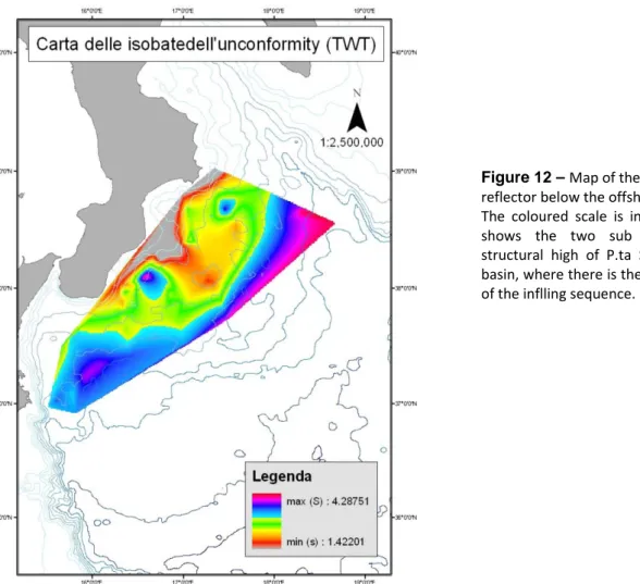
The subsidence of the basin in the offshore region is mainly Pliocene‐Pleistocene in age. The Crotone‐ Spartivento basin is divided by a structural high located off Punta Stilo, immediately to the south of the Catanzaro isthmus (Fig. 12). The two sub‐basins present some differences (Barone et al., 1982; Barbieri et al., 1982). The northeastern one, comprising the graben of the Squillace Gulf, is wider, has a maximum depth of 1700‐1800 m, and is characterized by a diapiric structure, while the southwestern one is narrower. The basin Figure 11 – (a) Lithostratigraphic chart of the proximal portion of the Calabrian forearc basin fill; (b) Generalised stratigraphic relationships in the same area. No scale implied (Cavazza and De Celles, 1998)
20
filling starts earlier in the Aquitanian (on‐shore outcrop of Stilo–Capo d’Orlando Fm., Cavazza & De Celles, 1998) and reaches a depth of about 2000 m (Fig. 11). The basin is characterized by an extensional tectonics with synsedimentary faults and typical features related to the Messinian salt tectonics (M/A reflector). The basin is also affected by sliding and slumping, as suggested by the dredge and cores recovered in the basin by Barbieri et al. (1982). The stratigraphy of the basin consists of: ‐ the Upper Miocene unit, which is exposed onshore in the Crotone basin and is probably correlated with the transgressive Serravallian to Tortonian sandstone and mudstone of the S. Nicola Fm. and Ponda Fm. Estimating the thickness of this unit is very difficult in seismic profiles; however, by considering the well stratigraphy in shallow water areas, the average thickness should be about 1000‐2000 m. These post‐orogenic sediments disconformably cover the stacking of Calabria‐Peloritani Arc, which is made up of crystalline and carbonate thrust sheets. These sheets were deformed during
Figure 12 – Map of the isobaths of the M reflector below the offshore forearc basin. The coloured scale is in sec TWT. The map shows the two sub basin, divided by structural high of P.ta Stilo, of the forearc basin, where there is the maximum thickness of the inflling sequence.
21
the lower Miocene time (see chapter 2) and were reached by onshore and offshore wells. On top of this sequence, an infra‐Messinian angular unconformity, tied with near coastal industrial wells, cross‐cuts all the previous structured Miocene sequence. On top of the Messinian unconformity, in spite of its limited thickness and high seismic velocity, fig. 10 (a) shows thin layer of Messinian salt. ‐ a thick, Plio‐Quaternary, subhorizontal and well‐stratified sequence infilling the basin. The wells stratigraphy onshore and in shallow water area show conglomerates and sandstones fining upward to marine shales related to an increasing widespread subsidence. The thickness of the infilled sequence varies from 0.4 s TWT up to more than 2 s TWT. This slive is often deformed by diapiric structure. In the sedimentary filling we can recognize several unconformity related to the complex tectono‐stratigraphic history of the basin. The most clear is the infra‐Pliocene angular unconformity evident near the Calabrian slope. This unconformity bounds the lower Pliocene Trubi Fm, which is a quasi‐transparent layer.
Near Crotone, also the middle‐upper Miocene sequences are involved in compressive deformations related to the growing and accretionary history of the prism. The Pliocene‐Quaternary sediments, conversely, are affected by synsedimentary normal faulting, tilted blocks, rollovers and extensional diapirs in the landward inner sector of the basin, and by compressive tectonics (folds and thrusts) in the outer sector, probably in relation with a gravity sliding processabove a salt layer. The landward boundary of the Crotone‐Spartivento basin (Calabrian slope), near the Crotone peninsula, is instead affected by huge complex gravity sliding and slumping involving the sedimentary cover, made up of Pliocene and Pleistocene clays, dredged along the slope (Rossi e Borsetti, 1974), above the salt layer (M reflector). This matter will be discuss in Chapter 3.
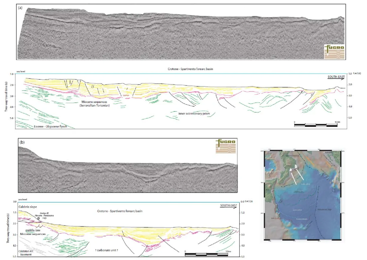
Fig 13 shows, below the present forearc basin, the southward dipping reflectors of the Calabrian block consisting of the Sila crystalline unit, which is exposed onland and partly overthrust onto the carbonate formations of Mesozoic age. The Plio‐Quaternary offshore tectonics of the basin is characterized by a regional subsidence, interrupted in several moments by compressive deformations (thrusts and backthrusts with Pliocene piggy back basins) as shown in Fig. 13 (a) and (b) and extensional reactivation of the previous compressive structures.
22
Figure 13 – Two seismic reflection profiles, data supplied courtesy of Fugro, and line‐drawing related from the Crotone‐Spartivento forearc basin. See inset for location of the sections displayed in this figure. In yellow the Plio‐Quaternary sediments, in pink the A (M) reflectors, and in green undefined pre‐Messinian reflectors. Near the Calabrian coast, where calibrated, below the Messinian unconformity Tortonian to Serravallian unit, outcropping in the eastern side of the Sila Massif (S. Nicola and Ponda formations) are
23
6.3.2 Inner accretionary wedge
The inner accretionary prism extends from the southern boundary of the forearc basin, the forearc outer thrust, to the main frontal thrust. This ramp represents the locus where the basement unit of the Ionian plate is involved in the accretionary structure. In the western sector, the ramp is extensionally re‐activated.
The extreme tectonization of the accretionary complex and the lack of stratigraphic constraints make very difficult the geological interpretation of the seismic profiles.
This sector of the accrectionary complex is an arcuate belt, 130‐140 km long and 280‐300 km wide on average. It consists of a nappe stack of pre‐Messinian units scraped‐off from the downgoing plate. It is characterized by several NE‐SW oriented and southeast verging thrusts, deforming in same cases the M reflectors. On top of the M reflector, a thin layer of Plio‐Quaternary sediments is present and locally deformed by a post‐Messinian reactivation of the previous structure. The inner wedge can be divided into two domains with different topographic slope by the Crotone‐Spartivento slope (Rossi and Sartori, 1981) which is a morphological element of the Ionian offshore. This structure has been previously interpreted either as the superficial expression of the subduction zone (Sioni, 1996) or considered as one of the main thrusts of the Calabrian Arc (Rossi and Sartori, 1981). The inner portion of the inner wedge is 60 km long and has a topographic slope of 0.6° whereas the outer portion, having the same length, has a 0.14° of slope. The slope have a vertical displacement of 0.6 s (TWT). Figure 14 – Line drawing (a) and seismic reflection profiles (b), data supplied courtesy of Fugro, of the structure of the inner accretionary wedge. The reactivation of this structure is clearly post‐Messinian in time.
24 In the southeast sector of the inner prism, we observe a spectacular inversion structure (Fig. 14) that involves basinal sequence, with reflectors of high amplitude and lateral continuity. This structure has not so far been depicted. The age of such inversion is not clear, but we suggest a post‐Messinian reactivation, by analogy with other structures. In map view, the inverted structure closes toward the southwest. 6.3.3 Frontal ramp and outer accretionary wedge
The outer wedge extends from the main frontal thrust to the foreland basin, to the south, and pinches out against the Malta Escarpment, in the western side. Toward the east, the wedge tapers until it disappears in the contact zone with the Mediterranean Ridge. The total length of the outer wedge is about one hundred kilometers toward the abyssal plain, and forty kilometers toward the Malta Escarpment (Fig. 15). Figure 15 – (a) Isopach map of the outer accretionary wedge from the main frontal thrust to the foreland basin. Has been considered the thickness between A and B reflectors as shown in profile AB, a synthetic line drawing crossing the outer accretionary prism (b). The thickness is expressed in TWT ‐ two way traveltime (s) (c) computed isopach map from seismic reflection profiles using Gocad; the color coded bar show the thickness expressed in TWT (s), in pink the maximum thickness.
Toward the south the Calabrian accretionary wedge is thrust onto the wedge shaped subducting Ionian sediments. The frontal ramp, thus, divides the mobilized domain of the Calabrian accretionary complex from
25
the foreland basin. In map view, this element has a convex shape running from the eastern margin of the Hyblean plateau, as previously described, towards the Apulian plateau, where the seismic grid is less dense. Along this ramp the basal décollement rumps into the top shallow part of the subducting sequences. We thus consider this ramp as the main frontal thrust of the wedge. The outer accretionary wedge, at the front of the main frontal thrust, displays a thickness varying from 1.8 s TWT to 0.3 s TWT. This wedge is bounded by the A and B reflectors, which represent the base and top of the Messinian unit (ME), respectively. Direct information constraining the A reflector comes from some piston core and Deep Sea Drilling Project Site 374, which penetrated the Plio‐Quaternary sequence and over 80 m into the Messinian evaporite formation (Hsu et al., 1978). The B reflector is taken from Finetti and Morelli (1973). The presence of the evaporitic layer on top of the outer wedge is also confirmed by the ESP 4‐5 (de Voogd et al., 1992) running seaward of the Calabrian wedge (foreland basin) and further upslope onto the Calabrian prism. This sedimentary wedge is a quasi‐transparent layer without internal reflection and follows the sedimentary wedge as observed at the foot of the Malta Escarpment. This body extends from the eastern side of the Hyblean plateau, where it pinches out toward the Malta Escarpment, to the Messina abyssal plain, where, toward the east, it is restrained by the frontal thrust of Mediterranean ridge. The origin and nature of this body will be discussed later. On top of the wedge, a thin sequence of Plio‐ Quaternary turbidite deposits occurs (Muller et al., 1978; Hieke, 2000). The PQ unit gets thicker towards the Ionian abyssal plain (i.e., 450 m in ESP 5). The Plio‐Quaternary unit shows small folds, which creates the cobblestone topography (Hersey, 1965), well know in the Ionian abyssal plain. Three different hypotheses have been put forward: they might be megaripples (Emery et al., 1966), collapse structures caused by karst processes (Hinz, 1974; Ryan et al., 1973), gravitative, plastic and viscous flows in the frontal thrust area (Rossi and Sartori, 1981), or compressive deformation related to the advancing basal décollement. Below the outer wedge, it is possible to observe the subducting sediments characterized by subhorizontal parallel reflectors mainly consisting of Mesozoic and Tertiary clastic sequences, and Ionian crust, as suggested by the related refraction velocity.
Several authors (Rossi and Sartori, 1981; Finetti, 1982) deemed the outer wedge as an allochthonous gravitative slide or melange without real compressive deformations inside.
6.3.4 Foreland basin and intra‐plate deformation zones
The foreland basin is represented by a triangular shape flat basin coincident with the Ionian abyssal plain. It ends against the Medina Mount, a complex horst structure affected by volcanism (Finetti, 1982). Here the seismic stratigraphy has been calibrated using a drill site 374 and a refraction data of ESP 5. The Ionian basin is the foreland for both the Calabrian Arc and for the Mediterranean Ridge. The toe of the accretionary complex
26
is not clear in the seismic profiles. We take, as beginning of the foreland basin, the point where the PQ unit lies subhorizontally (Fig. 16). The seismic sections reveal intense compressive deformation of the basement unit during Tortonian time. Deformation consists of numerous reverse faults down to crustal level. The reverse faults are mainly oriented NE‐SW and the total amount of shortening is 5‐6 km (Chamot‐Rooke et al., 2005). This event was probably responsible of the rise of Medina Mounts, even though, at some places, the faulting along the escarpment seems still active (Hieke et al., 2003).
In the foreland basin, the PQ unit is undeformed and lies horizontally above the evaporitic layer (ME unit), which is mainly composed of an upper evaporitic layer and a lower more clastic one. Moving toward the prism, the PQ shows little deformation with small wavelength folds (cobblestone topography).
The Medina Mount (including its prolongation as VHStr, named Marconi seamount by Finetti (1982), NStr (Hieke & Vwanninger, 1985) and VaStr (Hieke et al., 2003)), which is located between the Sirte margin and the Ionian abyssal plain, shows sharp NE‐SW escarpments. In places, the Medina Mount structures rise the seafloor, thus suggesting a recent extensional tectonics. A vertical displacement of about 0.1 s TWT of the M reflector above NStr indicates post‐Messinian movements (Hieke et al., 2003). Below the B reflector, a well‐ stratified sequence up to Mesozoic is present. In the central abyssal plain, this sequence is affected by compressive deformation expressed by numerous reverse faults and backthrusts dipping toward the southeast and the northwest, respectively, with synkinematic strata on top of the pre‐Messinian reflectors, which are southeastward‐dipping. These faults are crustal features, which could be related to a basin inversion re‐activating previous extensional faults. The Messinian evaporites do not seem affected by the compressive deformation and the timing of this intraplate event is probably Tortonian in age (Chamot‐Rooke et al., 2005; Sioni, 1996). The total thickness of this unit, depending on the chosen interpretation for the top of the crust, is about 3‐4 km as suggested by geophysical data (de Voogd et al., 1992). The unit is mainly composed of thick Mesozoic carbonates and tertiary clastic sediments. According to Hieke et al. (2003), the deformation pattern of the pre‐Messinian reflectors indicate a tilted block and horst‐like feature created by extensional tectonics.
27 Fi g u re 1 6 – MS 27 s e is m ic re flectio n pro
file and lin
e lo cated in th e Ionia n o ff s ho re . Th e ge olo g ic a l at tr ib ut es of th e re flec to rs are b a s ed o n re fra c ti on v e loc ity s u rvey (ESP 5, de Vo og d et al., 1 9 9 2 )
