bioingegneria
Corso di Laurea Magistrale in Ingegneria Informatica
A distributed framework for
proximity-aware Android
applications
RELATORE
Prof. Sam Jesus
Alejandro GUINEA
MONTALVO
TESI DI LAUREA DI
Luca BAGGI
Matr. 814638
Marco MEZZANOTTE
Matr. 816479
Anno Accademico 2014/2015
During last few years smartphones evolution affected our lives, changing real world interaction such as innovative ways to get in touch with other people using social networks, and providing internet network connectivity almost all the time. This evolution led smartphones to embed more and more sensors (e.g. motion, location sensors, etc.) useful to infer previously unavailable -user context information: the latters were exploited by smart applications to properly change their behaviour; these applications are called context-aware apps.
In this thesis we focused on a particular category of context-aware apps, the location-aware ones, taking into account indoor proximity data: this informa-tion is currently used to customize apps user experience on the basis of user surroundings, as in targeted advertising tasks.
What we propose is a framework, called Android Distributed Proximity Frame-work (ADPF), supporting Android developers to implement this kind of appli-cations. ADPF provides a set of API to subscribe to proximity events about application actors (e.g. the relative distance between them) and additional functionalities, such as actors grouping, to enrich information on these events. Using ADPF developers can easily build proximity-aware apps transparently with respect to technologies producing proximity information, through a com-mon high-level interface.
Opposite to existing solutions, the framework doesn’t rely on a central com-putational node and only needs a standard WiFi network to work.
Nel corso degli ultimi anni l’evoluzione degli smartphone ha influenzato fortemente le nostre vite, cambiando il modo di interagire con il mondo reale, in particolare a livello sociale con l’avvento dei social networks, e permettendo di essere sempre (o quasi) connessi a Internet. Durante questa evoluzione si `e verificata una continua integrazione di sensori (di movimento, di posizione ecc.) utili a ottenere sempre pi`u informazioni sul contesto nel quale agisce l’utente: ci`o ha permesso lo sviluppo di nuove applicazioni, in grado di modificare il proprio comportamento sulla base del contesto stesso; tali applicazioni sono dette context-aware apps.
La nostra tesi si concentra su una particolare categoria di context-aware apps, le cosiddette location-aware apps, prendendo in considerazione informazioni relative alla proximity in ambienti indoor: esse sono attualmente utilizzate per personalizzare l’esperienza dell’utente sulla base di ci`o che si trova in prossimit`a rispetto ad esso, come nel caso della pubblicit`a mirata.
La nostra proposta `e un framework, chiamato Android Distributed Proximity Framework (ADPF), per supportare gli sviluppatori Android nell’implementazione di tali applicazioni. ADPF offre un insieme di API che permette di sottoscriversi ad eventi di proximity riguardanti gli “attori” dell’applicazione (es. la distanza relativa fra di loro) e altre funzionalit`a, come la possibilit`a di raggruppare questi ultimi, in modo tale da arricchire le informazioni su tali eventi.
Grazie ad ADPF, un programmatore pu`o sviluppare una proximity-aware app in modo totalmente trasparente rispetto alle tecnologie utilizzate per produrre
nodo centrale di elaborazione, ma il tutto avviene in un contesto distribuito; pertanto, per funzionare necessita soltanto di una rete WiFi standard.
Ringraziamo Sam Guinea, relatore di questa tesi, per il continuo supporto al nostro lavoro, la grande disponibilità e la professionalità dimostrate. Grazie inoltre agli amici universitari e non per averci sostenuto nei momenti difficili durante il nostro percorso di studi.
Luca e Marco
Ringrazio la mia famiglia, per la continua fiducia riposta in me e per tutti i sacrifici fatti per permettermi di raggiungere questo traguardo. Grazie a Sonia, per essere sempre stata al mio fianco in questo percorso, e per avermi aiutato, sostenuto e motivato in ogni momento di difficoltà. Grazie a tutti i compagni con cui ho af-frontato questi anni di università: sarebbero troppi i nomi da citare, ma sono certo che ognuno di loro saprà riconoscersi leggendo queste parole.
Infine grazie a Marco, con cui ho condiviso gioie e dolori di questa tesi: non avrei potuto desiderare compagno migliore.
Luca
Un ringraziamento speciale va alla mia famiglia che da sempre ha creduto in me e mi ha sostenuto in ogni scelta fatta, dandomi fiducia anche quando pochi l’avrebbero fatto. Grazie a Selena per avermi aiutato a superare i momenti di scon-forto e le difficoltà di questi ultimi anni. Infine un grazie ai miei compagni Filippo e Tommaso per questi 5 anni di università passati assieme: affrontarli con voi è stata tutta un’altra storia.
Non saprei come ringraziare Luca per il lavoro svolto fianco a fianco, la passione e la determinazione dimostrate.
List of Figures xiii
List of Tables xv
Listings xvii
1 Introduction 1
2 State of the art 5
2.1 Technological overview . . . 6
2.1.1 WiFi . . . 6
2.1.2 Radio Frequency - Ultrasonic signals . . . 8
2.1.3 Bluetooth . . . 8 2.1.4 Geo-Magnetism sensing . . . 14 2.1.5 LTE Direct . . . 15 2.2 Platform overview . . . 16 2.2.1 Redpin . . . 16 2.2.2 ActiveBat . . . 17 2.2.3 Cricket . . . 18 2.2.4 Navizon . . . 19 2.2.5 Insiteo . . . 19 2.2.6 Allseen - Alljoyn . . . 20 2.2.7 Google Nearby . . . 22 2.3 Conclusions . . . 23 3 Our framework 25 3.1 Problem analysis . . . 26 3.2 Use cases . . . 27 3.3 Functional requirements . . . 29 3.4 Non-functional requirements . . . 30 3.5 Framework abstractions . . . 30 3.5.1 Entity . . . 30 3.5.2 SelfEntity . . . 31 3.5.3 DistanceRange . . . 31 3.5.4 POI . . . 32 3.5.5 Group . . . 33
3.8 Communication . . . 35
3.9 Security . . . 36
3.10 Framework working principles . . . 37
4 Library architecture 43 4.1 Architecture overview . . . 44
4.2 Group-Entity Interface . . . 45
4.2.1 Utility classes and interfaces . . . 46
4.2.2 Abstractions objects . . . 49 4.2.3 Subscription events . . . 52 4.2.4 POI Events . . . 54 4.2.5 ClientProximityAPI . . . 55 4.2.6 Framework messages . . . 56 4.2.7 GroupEntityManager . . . 62 4.3 Technology Interface . . . 73
4.3.1 Utility classes and interfaces . . . 74
4.3.2 TechnologyManager . . . 76 4.4 Technology level . . . 78 4.4.1 BLEProvider . . . 80 4.4.2 GeofenceProvider . . . 81 4.5 Security layer . . . 82 4.6 Network layer . . . 84 4.6.1 MQTT . . . 85
5 Results and evaluation 87 5.1 Test and tuning parameters . . . 88
5.1.1 Test parameters . . . 88 5.1.2 Tuned parameters . . . 88 5.2 Experimental setup . . . 89 5.2.1 Log messages . . . 89 5.3 Testing tools . . . 93 5.3.1 LoggerService . . . 93 5.3.2 TcpServer . . . 94 5.3.3 MySQL database . . . 94 5.3.4 Ntp Server . . . 95 5.3.5 TestClient . . . 95
5.4 Tests and results . . . 98
5.5 Conclusions . . . 116
6 Conclusion and future works 119
2.1 iBeacon packet schema . . . 10
2.2 Eddystone packet schema . . . 13
2.3 Alljoyn network architecture . . . 21
3.1 Framework network schema . . . 36
3.2 Proximity computation . . . 39
4.1 Architecture overview . . . 44
4.2 Simplified class diagram for Group-Entity Interface layer . . . . 46
4.3 Group.evaluate method flow chart . . . 51
4.4 Topology example: devices “far” from beacon . . . 70
4.5 Topology example: devices “near” to beacon . . . 70
4.6 Simplified class diagram for Technology Interface layer . . . 74
4.7 Providers passing data through PassiveTechnologyListener . 78 4.8 TechnologyManager passing requests to providers . . . 79
4.9 Technology level simplified class diagram . . . 80
4.10 Security Layer class diagram . . . 84
5.1 Toy example - Logging . . . 90
5.2 TestClient window . . . 96
3.1 DistanceRange table . . . 32
5.1 Dispatching time table . . . 101
5.2 Routing time table . . . 103
5.3 Routing time table . . . 104
5.4 Average dispatching time for geofence events . . . 106
5.5 Entity object memory schema . . . 107
5.6 Time intervals between CHECK OUT false and PROPERTIES UPDATE108 5.7 Time intervals between SYNC REQ and SYNC RESP - before fix . . 110
5.8 Time intervals between SYNC REQ and SYNC RESP - after fix . . . 110
5.9 Message count table . . . 112
5.10 Packet loss rate table . . . 115
4.1 CHECK IN message . . . 57
4.2 CHECK OUT message . . . 57
4.3 PROPERTIES UPDATE message . . . 58
4.4 PROX BEACONS message . . . 59
4.5 PROXIMITY UPDATE message . . . 60
4.6 SYNC REQ message . . . 60
4.7 SYNC RESP message . . . 61
5.1 REC MSG log . . . 91
5.2 SENT MSG log . . . 91
Introduction
During the last few years we lived a revolution due to the advent of smart-phones which play an increasingly central role in everyday life. Not only these devices have changed the social interaction rules, providing broad access to so-cial network platforms and introducing new information spreading paradigms, they have enabled always on network connectivity.
Smartphones also gained lots of sensors through which it is possible to infer new information about a user’s surroundings: for example, most smartphones now have embedded daylight sensors, motion sensors, location sensors, etc. These embedded sensors enable new kinds of apps: the so called context-aware apps, smart applications which adapt their behaviour on the basis of actual real world context. A particular category of context-aware apps are location-aware apps: they change their behaviour depending on the user’s geolocation, as retrieved by GPS sensors or other network services.
Location-aware apps that use outdoor location information have been very effective. As a result, several organizations started showing interest for these kinds of applications, and began trying to reach similar results in indoor envi-ronments. The main issues with indoor location-aware apps is the technological limit of the involved sensors: in particular, GPS sensors don’t work indoors, and the geolocation information that can be inferred by cell towers needs to be provided by Internet deployed services which are not as accurate as some
applications might.
In most applications location context data are used to get the relative distance between two application actors: for example, in the case of proximity market-ing, couponing and similar applications, the need of precise absolute location is not imperative and the cost needed to get it wouldn’t be motivated. A direct outcome is that leading companies are developing new technologies and standards in this field: Bluetooth Low Energy technology (BLE) and LTE-Direct are only a couple of them. A key aspect is that there is also a strong need to maintain good power efficiency.
Current solutions mainly provide absolute location data using centralized ar-chitectures: this usually leads to high deployment costs and further constraints, such as the need for internet access in the case of cloud-based solutions. Fur-thermore, almost every solution we analyzed relies on a single proximity tech-nology, limiting possible scenarios[1, 2, 3, 4].
With our work we aim to provide a technology-independent interface through which applications that need to operate indoor can retrieve proximity infor-mation. In addition, we want to keep our solution as simple as possible to deploy and maintain.
We provide a framework for proximity-aware apps that mainly focuses on indoor environments called Android Distributed Proximity Framework (ADPF). It uses a distributed approach and a simple WiFi network infras-tructure to keep deployment costs as low as possible. Our target was to make developers’ work easier through simple abstractions, hiding low level technolo-gies and the complexities of data integration. In particular, we aim to provide periodic proximity and “raw presence” updates, namely entry and exit events from considered indoor environment.
The approach follows a publish-subscribe pattern, suitable for event based scenarios like the ones ADPF has to deal with.
In order to also provide targeted updates on group of entities we offer group-ing functionalities. To do this we abstract application actors as virtual entities
needs: group subscriptions signal when someone leaves or joins a group, to-gether with network presence data; proximity subscriptions are used to receive relative distance updates; finally geofence subscriptions allow the programmer to be notified of entry or exit events related to geofences that are built around entities.
In order to automatically manage the available indoor proximity technologies, the framework introduces ad-hoc objects called Points Of Interest (POI): they are entity containers, and are used as triggers to enable indoor ADPF notifica-tions, meaning that upon a user enters in a POI the framework makes the client app aware of this entry event and starts to provide proximity information. In our first release, the framework supports Bluetooth Low Energy for indoor proximity data, while GPS is used to get geolocation data (useful for POI re-lated events). The rapid evolution of technologies and standards, especially for indoor environments, motivated us to make ADPF easily extendable, be able to exploit new technologies as quickly as possible and integrate their proximity data capabilities.
ADPF is suitable for several indoor proximity contexts: from classic re-tail store tasks, such as couponing and custom offers, to emergency support activities. ADPF however also tackels device-to-device proximity scenarios, enabling smart interactions between app users. This aspect can be really use-ful in social-oriented contexts, such as exhibitions or conventions, especially if combined with user profiling capabilities.
ADPF is a framework built for the Android platform, and is implemented as a standard Android Service. It is kept always running in the background. This means that it reacts to POI events and fires application events, even if the application itself is stopped or paused. As previously stated a standard WiFi network is required in indoor environments, and a publish-subscribe paradigm is used to maintain good scalability performances. We adopted MQTT for this
purpose, a TCP based protocol with various free message brokers implemen-tations.
We also took into account security and privacy aspects; they are explained in detail in chapter 4.
The last part of our work was focused on evaluating the framework’s perfor-mance and scalability. To achieve this goal we implemented a Java application that simulates an environment with a high number of devices and beacons. Using it we were able to get performance metrics, such as average event “firing time” or messages routing time, and inspect the framework’s behaviour with a varying number of devices.
Our evaluation show a good overall performance of the framework in several scenarios that are comparable to real world situations.
As possible future works, we pointed out ADPF implementations for other mobile platforms such as iOS or Windows Mobile, together with the integration of new proximity technologies. Furthermore, in lots of scenarios, could be useful to automatically manage also “active technologies” such as NFC and QRCode, involving direct user interaction.
State of the art
Location-aware mobile apps in the past years were mainly focused on outdoor environments due to the built-in technologies smartphones had in that period. In particular the GPS sensor was the most used in these apps for this purpose: from road navigation systems to activity tracking applications it was able to fulfill all their needs.
Now we are living an evolution of these smart applications bringing their capabilities indoor: proximity marketing, home automation and indoor navigation are only few of the fields in which this capabilities are required. This chapter describes the evolution in indoor-location, the currently adopted solutions and the ones available in the near future.
The first section describes several approaches used in last years from the technological point of view, with a brief evolution of its usage over time. The second section examines solutions currently available in commercial products and the platform supporting them, with a brief description of the additional features offered.
2.1
Technological overview
In this section we’ll see an overview of the currently available technologies for indoor location purposes and some projects where these technologies were used.
2.1.1
WiFi
The first experiments in indoor location field were based on wifi networks. The main advantage using wifi is the broad diffusion of this technology in most of interesting environments like offices, homes and several city areas.
In wifi-based location projects, three main approaches have been taken into account and we want to describe them below.
Fingerprinting
The idea behind fingerprint is mainly based on having a “discrete environment model” from the location point of view: this means that the whole environ-ment considered for indoor-location activity is divided into predefined areas, for example a 3 ∗ 3 meters square: the systems using this technique most of the times return location results based on the aforementioned discrete model instead of a continuous one. For example in Redpin project’s tests[5] when the user queries the system for his own location the system returns the room number having most similar fingerprints.
A fingerprint is usually composed by a tuple of signals parameters (such as network identifiers, signal strength, and access point information) from differ-ent access points in order to map this fingerprint with the real location where data were measured.
Most of the systems maintain a database with the set of all fingerprints mea-sured for each “discrete area” in order to compute the similarity between user measures and stored ones and return a location best estimate.
phase where several measurements are performed, for each area in the envi-ronment, in order to detect and store these fingerprints and their maps with areas, and a second phase where the running applications periodically com-putes the fingerprint resulting by consequent scans and look for a match on the previous phase mapping; if it finds a match the mapped real world area is considered the actual user/device location.
This technique led to poor results mainly due to WiFi RSSI measurements deviation: for example in case of the Redpin[5] project the requirement was to have room-level accuracy (where room’s walls mitigate measurements vari-ations over time) using WiFi, Bluetooth and GSM network fingerprints.
RSSI
In this case the idea is to maintain a list of the wifi APs in the considered environment with their own respective absolute location coordinates. Each device detects several signal strength levels from near APs and then uses a trilateration algorithm in order to identify its real absolute location.
As shown in [6] an algorithm has an average deviation of 0.85m considering an 8 ∗ 7 m2 room with 3 APs inside.
The main problem in this approach is the signal path loss model that should take into account several possible scenarios: a line of sight between signal transmitters and receivers, or an interrupted path due to obstacles presence and also signals reflection caused by walls or objects surrounding both receivers and transmitters.
TDoA
In the idea of TDoA[7] (Time Difference of Arrival), the position of an object is calculated by measuring the time taken from a packet being sent from a transmitter device to being received by a receiver. By means of Wi-Fi, a client transfers out a time embossed signal which is received by the APs. From the dissimilarity in time between sending and receiving the signals, the distance
between the AP and the client can be designed. When 3 access points are been used, by the principle of triangulation, it’s possible to establish location of a client to an accuracy of less than 5 meters[8].
2.1.2
Radio Frequency - Ultrasonic signals
Radio frequency and ultrasonic signals were used in first indoor location ap-proaches: projects using them are mainly older ones because smartphones were not broadly diffused or they had limited capabilities, forcing the use of dedicated hardware to attach to mobile entities tracked.
In last months some projects as Google Nearby[9] brought it back to the front in proximity communication field thanks to newer smartphones computational capabilities: as explained better in the following subsection, Nearby uses an inaudible sound to transmit small data packets between devices; it exploits the fact that if two devices can exchange a valid data packet in this way, then they are one next to the other.
2.1.3
Bluetooth
Bluetooth is the mostly used technology in indoor-location field because of its broad diffusion on everyday life devices (such as smartphones, tablets, cars, etc.) and the interesting features offered by its latest implementations: for example Bluetooth 4 introduces new low energy capabilities, allowing new power and interaction modes and a service-based architecture through the attribute protocol (ATT).
Furthermore, the low cost of hardware platforms makes solutions based on Bluetooth the preferred ones for commercial applications.
First experiments
Some old experiments such as the one reported in Hallberg’s work[10] started using as beacon whatever Bluetooth-enabled device, from PC keyboard
adapters to mobile phones. This method uses bluetooth connection’s RSSI in order to compute the mobile unit’s position (which is the information they wanted) through the distance from the beacon and beacon’s position stored by a “positioning service”. In this paper they reached an average position error of 1.7m +/- 1.7m.
Several applications were implemented on top of similar architectures (or even simpler ones, like exploiting only device to device detection), where dis-tance accuracy was not so crucial as for other applications: applications like MobiTip[11] (a mobile proximity based recommender system) or social cen-tered applications, usually need raw proximity information.
In latest years the “beacons approach” has shown to be successful in lots of application fields, and some companies, like Apple, made first steps in this field.
Bluetooth Smart and beacons
In 2010 Bluetooth version 4.0 was released and then completed in 2011 with the 4.1 version release. It introduced new features like a service-based architecture through the attribute protocol (ATT) and new power and interaction modes through Bluetooth Smart[12] (also known as Bluetooth Low Energy or BLE) specification: in particular low-energy mode and advertising communication mode are interesting for Bluetooth-powered beacons.
Bluetooth Smart beacons are Bluetooth Smart compliant devices and they act as packets emitter (see various formats in iBeacon - 2.1.3, UriBeacon - 2.1.3 and Eddystone - 2.1.3 sections): in fact, using low-energy features, they can periodically broadcast data packets that Bluetooth Smart (or Smart Ready) devices can listen[12] and use to perform context-specific actions; the advertising-only and low-power modes allow a beacon to have a really long battery life (even years in some cases). Furthermore smartphones can scan for advertised packets (also in a low-power manner) without the need to pair to transmitters, enabling ambient discovery tasks that is a key feature for BLE
beacons in context-aware applications.
The last features contributing to their broad diffusion is the low hardware cost they have: the average price is in a 5-40$ range depending on vendors, transmission power/range and battery life characteristics.
iBeacon
Apple was maybe the first making a move in the Bluetooth Low Energy beacons field developing a standard protocol called iBeacon that defines the broadcasted messages format: in particular it advertises a structured identifier that iBeacon compatible applications can use for trigger context-specific actions such as running background task, showing user notifications or launching apps.
Figure 2.1: iBeacon packet schema
As shown in Figure 2.1, the broadcasted packet composes of several fields; we will examine the PDU Data chunk:
• iBeacon prefix: this field contains some information about the beacon itself, such as the company code, or about the packet such as the
broad-casted packet type (in case of iBeacon packets last 2 bytes have fixed value 0x0215)
• Proximity UUID: is the beacon’s main identifier that most of BLE bea-cons libraries use to filter out detected beabea-cons
• Major: is an identifier used to group beacons with the same UUID • Minor: is an identifier used to identify individual beacons
• TX Power: is the strength of the signal measured at 1 meter from the iBeacon. This number is then used to determine how close you are to the iBeacon
An example could clarify the identifiers hierarchy: if Apple decides to de-ploy some beacons in each of its stores, it would define a unique UUID all beacons in all stores all around the world will broadcast; this will allow Apple devices to know when they entered an Apple store. In order to identify which Apple store they entered, the same major value would be broadcasted by all beacons in the same store. Finally, if the app would understand where the device is inside the store, all beacons in all stores would broadcast the same Minor value for the same location in the store.
UriBeacon
UriBeacon[13] is an open format specification for BLE broadcast packets. The project started in 2014 and its goal was to define a new way to discover nearby smart things and give a “web presence” to each of them (an IoT-oriented approach), proposing itself as a bridge between Open Web technologies and Bluetooth beacons.
A UriBeacon can broadcast both HTTP URLs (http and https), UUID URNs (128-bit universally unique identifiers) as well as other URIs.
Eddystone
Recently Google stepped into BLE beacons world with its own new open standard (available under the open-source Apache v2.0 license) called Eddystone (a kind of UriBeacon successor). As reported from Eddystone project’s website “Eddystone is a protocol specification that defines a Bluetooth low energy message format for proximity beacon messages. It describes several different frame types that may be used individually or in combinations to create beacons that can be used for a variety of applications.”
Respect to iBeacon this standard is more focused on broadcasting location information to nearby users (as beacon’s latitude and longitude) and it’s specifically designed to easily integrate applications in Google environment (using Google Nearby related services).
Furthermore Eddystone includes an ad-hoc module for beacons fleet manage-ment, called Proximity Beacons API: this API allows people who maintain beacons powered applications to manage large fleet of beacons in a centralized manner; this option enforces our beliefs in terms of beacons diffusion in the near future.
Eddystone differs from iBeacon because it’s an open standard and because it allows its devices to broadcast three different frame types where iBeacon had a single frame type broadcasting an UUID, a major and minor number.
In Figure 2.2 you can see Eddystone packets schema. Here we report a brief description of Eddystone’s frame types from specification[14]:
• Eddystone-UID: it’s the iBeacon parallel frame but it broadcasts a 16byte identifier where 10 bytes act as UUID (called namespace) and 6 bytes as instance (similar to major and minor in iBeacon)
• Eddystone-URL: this frame broadcasts a URL using a compressed encoding format in order to fit more within the limited advertisement
packet, using the encoded URL to access remote resource stored in Google’s cloud services.
• Eddystone-TLM: this frame broadcasts telemetry information about the beacon itself such as battery voltage, device temperature, and counts of broadcasted packets.
Figure 2.2: Eddystone packet schema
Google will include Eddystone support since Android Marshmallow 6.0 and will release an SDK for iOS devices in order to allow developers to create Eddy-stone powered apps: in fact EddyEddy-stone can be used in a “standalone” manner, as with iBeacon, listening for nearby beacons and react to their proximity on the basis of UID frames; anyway, its power is shown in Google environments and open source projects such as Physical web[15].
2.1.4
Geo-Magnetism sensing
Some studies reported quite accurate results obtained in indoor environments location using geo-magnetism sensors.
The paper Indoor Location Sensing Using Geo-Magnetism[1] describes this approach: in brief this method exploits geomagnetic field distortions caused by steel and concrete skeletons of buildings.
Paper authors investigated the magnetic-field inside a building in order to map magnetic field distortion. Using an electronic compass mounted onto a rotating robotic arm, they moved along a straight line (a corridor) and for each position they measured heading values; they stored these values with the corresponding real headings. They noticed that the heading error varied along the corridor, so they suspected that the error was due to the building’s structure.
The proposed system uses a fingerprint technique (see section 2.1.1) where a pre-deployment phase is performed in order to map indoor locations’ geomag-netic records with their corresponding real environment location. The clients, collecting the signature during their run, ask for a fingerprint match with a real location to the server that eventually reports back the matched location. In this system they used specific hardware with size constraints similar to smartphones size.
The mean error (of the paper proposed system) reported in case of atriums with radius greater than 15m is about 3m.
The limitation of the system is that the chance of error increases with the size of the fingerprint map, and the cost of mapping every space in a building may require significant effort and time using the presented method.
The advantages respect to other indoor-location systems like beacons-based (either WiFi or Bluetooth) is the lower deployment cost especially in large buildings and the immediate total covering of the building (obviously after the mapping phase).
2.1.5
LTE Direct
LTE is mainly known as a new wireless technology for data exchange but it’s also expanding into new frontiers as proved by its evolutions like LTE Advanced and LTE Direct[16].
LTE Direct uses the LTE licensed spectrum and is part of the Release 12 of the 3GPP standard. It is particularly interesting by the proximity point of view because it aims to provide an “always-on device-to-device proximity service” that scales on large number of devices, all in a distributed fashion. LTE Direct proposes itself as a reference technology to overcome main limits of current proximity services approaches using Bluetooth beacons or geolocation: in fact they either use centralized architectures (e.g. in location-based approaches) with privacy issues due to user tracking data, or have a small working range (e.g in case of Bluetooth beacons approaches a beacon range is about 40m) and are not suitable for “always-on modes”. LTE Direct instead allows a device to discover nearby devices or services in approximately 500m proximity range, making apps continuously aware of device surroundings in a battery efficient manner; furthermore it aims to work also in crowded environments, discovering 1000s of devices/services[16].
Mobile applications can instruct LTE Direct to monitor for nearby services on other devices or to broadcast their own services through Expressions, filtering data at the device level, without the needs of a centralized architecture or network pings. Moreover applications don’t need to keep running in order to react to Expressions but they can be notified of them directly by the device. LTE Direct-enabled devices broadcast local running services and requests through “Expression”: these are service-layer identifiers representing the of-fered or requested service, identity, interest or location. Other devices wake up periodically (e.g. every 10 seconds) listening for Expressions and broadcasting their own: for each Expression received, the latter is filtered on the basis of applications requests, and eventually notifies them of the proximity event.
2.2
Platform overview
In this section we are going to analyze main features of some platforms offered by several companies operating in indoor-location and mobile fields together with some academic projects developed. The aim of this overview is to under-stand indoor-location services history and new trends in this field.
We tried to group platforms by technology used with the same order defined in previous subsection.
2.2.1
Redpin
The Redpin project[5] is an open source fingerprint-based indoor location sys-tem specifically designed to run on standard mobile devices like smartphones. The aim of the project is to obtain room level location accuracy with a deploy-ment easier than previous proposed solutions: in particular here they exploit final users collaboration for training phase.
For each room mapped they record more than one measurement: each finger-print is the mapping between the room where measurement take place and the signal strength of the currently active GSM cell, the signal strength of all WiFi access points as well as the Bluetooth identifier of all non-portable Bluetooth devices in range.
The room level accuracy requested helped them to reduce measurement errors or fingerprint mismatch during application running, due to rooms’ walls signals absorption.
Redpin consists of two components: a Sniffer that runs on a mobile device and collects signals and fingerprints and a Locator component, that runs on a separate server. The Sniffer scans for signal sources and create the fingerprint while the application code gets the fingerprint and queries the Locator through the network for a corresponding location. The server instead keeps track of all collected fingerprints and their map with real locations (in this case with rooms names) and sends back to the Sniffer query results produced by the
location algorithm implemented.
The location algorithm tries to get a best match out of the given fingerprint: the algorithm uses a threshold value on the distance calculated as a similar-ity between identifiers and signal strengths; if the distance is not above the threshold the fingerprint is considered as “not matched”.
When Redpin application starts, it sniffs for GSM active cell, Wifi access points (recording respective signals strengths) and nearby Bluetooth non-portable devices’ IDs: sniffed data are sent to a central server that tries to locate the device given all know fingerprints. The Redpin application continuously sniffs for aforementioned data and queries the server. When a fingerprint match is found it displays to the user the detected location. If no fingerprint in the database matches the given one, than the user can suggest its current position in order to allow the central server to store the new fingerprint in the database: this collaborative approach can simplify the training phase that in other projects could take also some hours for large environments.
2.2.2
ActiveBat
ActiveBat[2] is an ultrasonic-based location system that uses the principle of trilateration.
System’s main components are: Bats, which are ultrasound receivers, and a central controller that coordinates the Bats and the receiver chains. Bats are ultrasound transmitters attached to tracked objects having the size of a car key; they are identified by a unique 48bit code and are linked with the fixed location system infrastructure through a radio link. Receivers are placed on the ceiling in a square grid, 1.2m apart, and are connected by a high-speed serial network.
When a Bat is to be located, the controller instructs it to send a short pulse of ultrasound, and its times-of-flight to receivers is measured. A DSP board executes the location algorithm and sends results to the application (running on a PC).By finding the relative positions of two or more Bats attached to an
object, they can calculate its orientation.
The main problem of the system is the large number of receivers required to be mounted on the environment ceiling, and their precise alignment.
2.2.3
Cricket
The Cricket system[3] is an indoor location system developed by MIT taken as reference in lots of academic projects on indoor-location: it has an architecture similar to modern Bluetooth beacons based systems.
Cricket consists of “nodes”, ad-hoc hardware platforms with a transceiver and a microcontroller onboard able to send signals over Radio frequency (RF) and ultrasonic band (US), and able to interface with a host device. There are two types of nodes: beacons that act as fixed reference points of the location system (usually attached to walls) and listeners attached to fixed or mobile objects that need to determine their location.
Beacons transmit their own location as coordinates, but when they are de-ployed they don’t know their coordinates: to solve this issue a listener at-tached to a host roams in the environment computing the distance between all beacons; the host then computes, on the basis of several measurements, a unique inter-beacon distances set used to build a uniquely coordinates set that defines the real beacons topology. Finally the host computes coordinates for each beacon such that they resemble real disposition.
Beacons periodically transmit a short ultrasonic pulse followed by an RF mes-sage containing beacon’s information like absolute location (in the form of aforementioned coordinates set), a unique beacon identifier, the physical space associated with the beacon, etc.
There’s no central coordination of beacons transmissions. Each listener listens to beacon transmissions, measures its distance from nearby beacons and uses this information to compute its currently absolute position: the distances are measured using a TDoA approach (see TDoA description in section 2.1.1) on RF and ultrasound signals (using the US pulse sent just before a beacon RF
message). If the listener has multiple ultrasonic sensors it can use distance difference information to compute its orientation.
The aim of the system was to have high location accuracy and ease of deploy-ment: the testing outcomes results in a 10cm position error with listeners fixed on a parallel plan with respect to beacons’ plan.
2.2.4
Navizon
Navizon[4][17] is a company that offers indoor-location services based on WiFi technologies. In particular they exploit smart WiFi nodes (similar to regular access points): each of them periodically detects WiFi-enabled devices such as smartphones, tablets, laptops or WiFi tags and records their MAC addresses and signal strength, pushing these data to a remote server hosted on a private or public cloud platform. The server estimates devices’ locations and records them in local. Each device can query the server through a REST API in order to obtain its own location.
In this case hardware nodes have to be deployed and at least one node must be connected to the internet (nodes form an ad-hoc network in order to allow each of them to push data to the remote server). For a whatever small environment, the company states that at least 5 nodes have to be deployed.
An accuracy of 2-3m is claimed by the company with a 15-20m spacing between adjacent nodes.
The platform provides a Proximity Engine through which the system adminis-trator can instruct the server to notify another “listener server” (using a POST message) about proximity events fired: these events can be defined as signal strength thresholds on a specific node of a specific site.
2.2.5
Insiteo
Insiteo is a company that offers indoor-location services such as navigation, geofencing and indoor maps. They have a configuration platform through
which devices can download setup data in order to run properly. Its solutions mix WiFi access points data with Bluetooth beacons (iBeacon compatible) and devices’ sensors such as accelerometers or pedometers in order to obtain better performance (claimed 2m by company website).
The platform they sell allows analytics tasks based on location data collected by devices, indoor map loading and management and devices configuration.
2.2.6
Allseen - Alljoyn
Allseen[18] is an open world-wide consortium that is trying to develop a global standard for IoT communications called Alljoyn.
Alljoyn is a framework that provides an ad-hoc proximal network to several devices running on different platforms and operating systems through a dis-tributed bus: in this way all devices connected to the same WiFi network (in the future other “transport technologies” could be supported) can communi-cate between each others using the provided interface.
The Alljoyn power is its capability to adapt to lots of scenarios thanks to service discovery functionalities offered in order to make applications aware of devices or services available on the network: a developer can easily build its own service, defining the Actions other peers can perform on it and the signals it can send out (Events); in this way developers can instruct applications with if-this-then-that rules for smarter interactions, even application-to-application interactions.
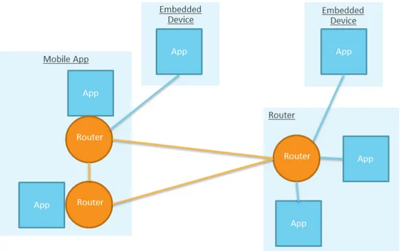
All communications are performed by a local or remote router instantiated by the framework on behalf of the application layer: for example in case of embedded devices with low computational capabilities the router used is a remote one that resides on a more powerful peer in the network (see figure 2.3).
The communication can happen in different formats like synchronous mes-sages, asynchronous signals (used for notification purposes), etc.
Figure 2.3: Alljoyn network architecture
source: https://allseenalliance.org
big companies interested in it. Due to the wide range of applications such a standard can have, some projects were started as “Alljoyn subprojects”, devel-oped by approved working groups, in order to implement some services useful to lots of applications: as an example a notification service has been developed in order to send text, audio or images notifications to peers in the network, a configuration service that allows peers to set a property of another peer through the network, etc. Between these projects there’s a Location Service Project[19]. It introduces the concept of Entity as a general item applications in the network are interested in and it consists of four different services we briefly describe here:
• Presence: this service announces the entry or exit of an entity to the proximal network. Network peers can query for the presence of an entity in the network or they can subscribe to entry or exit events
• Proximity: this service provides proximity data on the relative distance between an entity and a proximity service host. A peer can query for
a distance relative to an entity or subscribe to distance updates with minimum update interval or proximity variation constraints
• Location: this service provides absolute location data about entities both in a synchronous or asynchronous fashion (always with interval and location updates constraints)
• Containment: this service allows peers to query for the containment relationship between two entities. For example a peer can perform a query to know whether an entity A is contained by an entity B or vice versa
2.2.7
Google Nearby
Nearby[9] is a Google project that provides a Proximity API for iOS and Android developers; thanks to this API, Android and iOS devices can discover and communicate with each other, as well as with beacons.
In proximity field, Nearby uses a combination of WiFi, Bluetooth and inaudible sound (using the device’s speaker and microphone) to establish proximity and to communicate with devices in proximity.
The “handshake” between two devices in proximity is possible using Google Cloud Services for authentication purposes: this doesn’t means that only Google users can use the service, but the process transparently uses random generated tokens stored in the cloud to perform a kind of challenge-response mechanism and notify two involved devices of their proximity (without a dis-tance estimate).
The programmer can instruct the APIs with an indirect range setup: in fact he can limit the “scanning range” to Bluetooth and ultrasound or to ultrasound only range.
To communicate, Nearby exposes publish-subscribe methods, meaning that an app publishes a payload that can be received by subscribers in proximity. So, it is possible to build applications for:
• messages sharing (using Nearby Messages API): it is useful for interac-tions such as resource sharing or collaborative editing
• real-time connections between devices (using Nearby Connections API): it is useful for local multiplayer gaming and multi-screen gaming.
2.3
Conclusions
In this chapter we analyzed currently available solutions for location-aware and proximity-aware applications. As you can notice the focus is more on providing platforms location-oriented than proximity-oriented ones. We think the main motivation is the higher flexibility provided by location data: in fact proximity data can be inferred by location data these systems provide, moti-vating companies interests to develop location-oriented products for marketing reasons.
Furthermore almost all systems examined exploit centralized architectures and cloud features to provide smart interaction modes and data analysis or aggre-gation features not always needed.
As reported in previous sections, last years saw an always growing interest in location-aware scenarios from different points of view: providing new smart interaction modes and context-aware information quickly became a must for successful applications in whatever field, from “simple” smartphone applica-tions to data collect tasks and software.
Nowadays we are seeing this interest moving from technological development (protocols, sensors and technologies) to platforms and smart services offered (see section 2.2.7).
Our framework
The ADPF framework aims to define common abstractions suitable for proximity-aware applications, ensuring at the same time good flexibility and performance for current and future application fields.
Its focus is to provide new high level objects representing all kinds of actors involved, define a unique data representation suitable for different technolo-gies, and hide low level details to more easily face future evolutions from a technological point of view.
In section 3.1 we provide a general overview of the problems addressed by ADPF. Section 3.2 presents some general use cases pointing out key features and real world scenarios where ADPF could be deployed.
Sections 3.3 and 3.4 define functional and non-functional requirements as in-ferred from the use cases we present.
Section 3.5 gives a high level description of the abstractions used by the frame-work together with the frameframe-work’s main APIs which are explained in section 3.6.
Sections 3.7 and 3.8 describe ADPF’s architectural choices, while section 3.9 focuses on security and privacy aspects.
Finally section 3.10 illustrates ADPF’s working principles in order to give the reader an overall description of the idea behind framework’s implementation.
3.1
Problem analysis
Lots of location-aware applications, especially in those apps that use indoor-location data, need to know the relative distance between the device they’re running on and other devices or application specific “actors”: for example, in the case of proximity marketing or couponing an app needs to know when the user entered a shop in order to provide products offers, or custom advices. The key information used by the apps’ business logic is the proximity between these actors.
Nowadays location or indoor proximity information are mainly made available using a specific technology: for example, a shop can develop its own mobile app that uses the bluetooth beacons or WiFi based devices deployed therein for indoor-location purposes. Each of these technologies has its own library the programmer has to understand and integrate inside his app, taking into account all aspects not managed by the library itself. But what if an applica-tion scenario involves more than one technology?
Although our work is mainly focused on indoor environments, we also defined a “bridge” with outdoor technologies (exploiting the well-known macro-location facilities that are offered off-the-shelf by the development platform) so that the programmer can maintain continuous control over user context transitions. Section 2 pointed out some interesting facts about the indoor-location field: the recent development and release of new standards and technologies (see Google Eddystone in section 2.2), the importance of device-to-device proxim-ity awareness (see Google Nearby and LTE-Direct in sections 2.2.7 and 2.1.5) and the agreement on event-based communication between location services and applications. Furthermore, we thought it could be useful for a programmer to have device and object grouping functionalities.
As a result our framework takes into account all mentioned aspects and tries to face related problems providing straightforward approaches, as easy to use and as safe as possible. A distributed approach to the problem reduces technology
constraints for ADPF-powered applications, limiting costs and effort for their deployment.
The following sections explain all these features in detail, through some toy examples and application scenarios.
3.2
Use cases
In this section we are going to define some “general use cases” that encapsulate several scenarios and examples: they are not meant to show a particular ap-plication for indoor proximity but to motivate our framework’s functionalities in different situations.
Proximity notifications
Use cases belonging to this class are maybe the most known and most common because they represent the “101 toy examples” about indoor proximity and BLE beacons: retail stores, cinemas and stations are only a few of the contexts for these kinds of examples; couponing and targeted advices are the most valuable outcomes.
We would like to have the same functionalities in other situations, where proximity driven notifications can be powerful. Some examples might be the delivery of custom evacuation instructions to people in a building, in the case of emergency, depending on their current floor or room; the delivery of tracking notifications to warehouse employees; and queue waiting time estimates in public offices reported upon user arrival.
Besides this, in some situations it could be useful to automatically deal with surrounding changes: for example, a user can ask to be notified about the proximity to entities that have specific properties that evolve over time (e.g. “tell me when I’m near a vending machine that was refilled less than 2 days ago”).
Device-to-device proximity awareness
In the last few years social networks have been enriched with smarter func-tionalities. Some exploits user context data, from a post’s location to photo geotagging and event tagging of whatever content a user publishes.
Several academic projects and companies have started analyzing possible so-lutions to provide user proximity information in a reliable manner (see section 2.2.7): in the case of social networks, matching profiles or friends in a user’s surroundings can be exploited to provide “immersive” interaction modalities. For example, in a job fair users might want to be aware of whether they are near a company that has open positions matching their skills, or a company might want to be notified about the proximity of new candidates with certain knowledge.
In the smart ticketing field (for events or public transport) a ticket controller could use an app to discover people nearby without a valid ticket in a quick and easy manner, even in crowded situations. Furthermore, virtual leashes can easily be set in order to track pets or children (so that we are notified when they leave a defined space - e.g. a mart playground or a park).
Proximity triggers
In the growing IoT and smart home markets (see section 2.2.6), the chance to have smart appliances take actions on the basis of simple “if-this-then-that” rules seems almost a basic requirement. The machine-to-machine communi-cation that triggers these actions actually give smart products a competitive edge on the market.
The integration of proximity information as a triggering conditions can be useful in lots of cases: to enable stove security when children are nearby, to turn on the lights when someone enters in the house, to have an appliance emit a “task finished” sound only if somebody is in its surroundings, and so on. Triggers can be used to manage and generate whatever type of data. For example, they can be used to detect people nearby and collect statistics on
the basis of their properties. This kind of application can be useful for trends discovery and data forecasting.
3.3
Functional requirements
In this section we are going to define the functional requirements of the frame-work, as identified from the use cases presented in section 3.2.
• Common abstract entity
In order to keep our framework as flexible as possible, we use an ab-stract entity (with common description fields) to map each real world actor involved in an application. This way the framework can access all the actors through the same interface, distinguishing them only by framework relevant information.
• Device profile
Each device in the network has to maintain a description so that it can be identified in device-to-device proximity discovery, as well as advertise it in framework level communications.
• Proximity data
The framework has to provide proximity information to devices in the network, in terms of presence and relative distance.
• Always-running
The framework has to offer a wake up mechanism in order to react to proximity/location events even when the client app using it is in the background or stopped. An activation mechanism is needed so that energy consumption doesn’t waste the devices’ batteries.
• Notification mechanism
In the real world proximity events happen with no standard frequency or predefined instants. The framework has to deal with both synchronous
and asynchronous events based on the actors’ request types. For ex-ample a request could be to “give me all the entities within proximity” (synchronous) or “tell me when I arrive at my office” (asynchronous).
• Grouping
The framework has to offer the possibility to choose interesting entities so that it only receives relevant proximity events.
3.4
Non-functional requirements
We identified two main non-functional requirements: first of all, since we can connect devices and broadcast potentially sensible profile data, the framework has to allow the user to decide what and when to share information. Further-more, the programmer should be able to encrypt communications if activated by the application’s context. Secondly, we need to hide the complexities of proximity technologies so that future solutions can be easily integrated in the framework, and to lower the effort required of a programmer to manage his/her entities.
3.5
Framework abstractions
In this section we present the framework components we identified to abstract the above requirements. For the technical detail please refer to Chapter 4.
3.5.1
Entity
To fulfill the requirement of having a common descriptor for every actor, we defined a general component Entity. An Entity is represented by four fields:
1. entityID
This attribute uniquely identifies an Entity. It is not possible to define two entities with the same entityID.
2. entityType
This field is used to distinguish entities by their type. We currently support two types: DEVICE and BEACON. The framework offers the pos-sibility to easily extend the list of possible types (see section 4.2.1 for more details).
3. distanceRange
This represents a relative distance for the Entity. See section 3.5.3 for more details about DistanceRange.
4. properties
This attribute is used to describe the properties that are typical of each
Entity. These are only relevant from an application’s point of view. For example, the developer of an app for sports centers will add the fact that a user is interested in basket.
3.5.2
SelfEntity
SelfEntity is a particular Entity built by the framework; it describes the de-vice where the framework is running. It is used to address the need of a dede-vice profile, in order for the entity to be identified during framework communication (see section 3.3).
3.5.3
DistanceRange
To deal with the current technological limits in terms of distance computation accuracy[20], we decided to use a set of relative distances, each one representing a range of meters. In particular, we identified these distance ranges:
DistanceRange Description IMMEDIATE 0m - 0.5m NEXT TO 0.5m - 2m NEAR 2m - 4m FAR 4m - 8m REMOTE more than 8m
SAME BEACON entities are seeing the same beacon SAME WIFI entities are in the same network UNKNOWN no distance information available
Table 3.1: DistanceRange table
Latest three values reported in the table above are returned when there is no useful information to estimate relative distance between entities: SAME BEACON means that two entities (A and B) detect the same BLE beacon but it’s impossible to compute their proximity, SAME WIFI instead is used when A and B have detected no common BLE beacons but they are in the same environment (meaning that they can communicate). Eventually, UNKNOWN is used when there is not distance information at all.
3.5.4
POI
A POI, acronym for Point Of Interest, represents a real world location where there are entities that are deemed useful for the application. In practice this means that a POI identifies a location where there are beacons.
It is described by a name, a latitude, a longitude and a radius so that a geofence can be created, and a beaconUuid that is used to identify the beacons of interest. The idea is that a BLE scan (and Bluetooth activation) only occurs after the entry in the geofence. This way, the framework does not waste the device’s battery scanning for BLE beacons when it is useless.
3.5.5
Group
A Group is a set of entities that have something in common: to define it a programmer must provide an “entity prototype” that all group members have to match.
This prototype is described by:
• an entityID: if this field is defined, the group can be composed only by zero or one entity.
• an entityType: with this field, the programmer can decide to create a group based on entity type; the type can be DEVICE, BEACON or ALL (to select both devices and beacons).
• a propertiesFilter: through this attribute the programmer can define a filter on Entity properties. Thanks to propertiesFilter it is possible, for example, to create a group with all the entities that are interested in “western movies”.
It is important to notice that a Group only defines which entities are part of it. There’s no direct binding between a group and its entities (i.e. a group does not “physically” collect entities that belong to it). This is due to the fact that the Entity set changes continuously. Entities can change their properties, or they can enter(exit) in(from) the POI. Keeping an always updated list of entities for each group can be a time and energy consuming task, definitely infeasible in terms of memory consumption and energy expensive synchroniza-tion tasks.
3.5.6
Events
Here, we define events in a more fine-grained manner.
In particular, the framework identifies three different types of events:
1. Group events
produced when an entity changes its properties, or when an entity enters or leaves a POI.
2. Proximity events
These are the events that are strictly related to proximity. Every time an entity is in proximity to another, whether device or beacon, a proximity event is fired.
3. Geofence events
These are events that are fired when a geofence entry/exit happens. The geofence can be built around a beacon, or around a single device.
3.6
Framework APIs
In this section we explain how the framework interacts with the programmer. We explain the framework’s APIs from a conceptual point of view. For tech-nical details, please refer to chapter 4.
Given that there are three different types of events (see section 3.5.6), the framework offers the programmer three different types of subscription:
1. Group subscription
This is the subscription a programmer has to do to be notified about group events. A group subscription requires only one parameter, the
Group G the programmer is interested in to receive notifications: every time an entity enters(exits) in(from) G, a group event for that subscrip-tion is fired.
2. Proximity subscription
This is the subscription related to proximity events. The programmer has to pass an Entity E (which can be only selfEntity - see 3.5.2 - or a beacon), and a Group G: every time an entity belonging to G is in proximity with respect to E, a proximity event for that subscription is fired.
3. Geofence subscription
This represents the subscription for geofence events. In this case, the parameters required are an Entity E, a Group G and a DistanceRange D; the framework builds a geofence of radius D around E: every time an entity belonging to G enters/exits in the geofence, a geofence event for that subscription is fired.
The three aforementioned subscriptions are obviously asynchronous: the programmer subscribes for an event and, at a certain point, he will be notified of the firing of the latter.
ADPF offers also a synchronous method, to retrieve all the entities (eventually belonging to a Group) in proximity with respect itself in a certain instant of time. This could be useful for the programmer to have an overview of the application state in a certain moment, or to retrieve entities of interest. Finally, the framework provides obviously a function that permits the pro-grammer to unsubscribe from previously made subscriptions.
3.7
The distributed approach
We decided to store all the business logic needed to compute proximity, fire events and so on, on client side, i.e. on devices, without the help of a centralized server. This distributed approach differentiates ADPF from the totality of solutions currently available on the market (which are explained in section 2.2). We opted for a distributed solution in order to reduce deployment costs and physical hardware needed for developers who are going to use our framework for their applications.
3.8
Communication
As mentioned in non-functional requirements (see section 3.4) we needed a way to permit communication among devices: we decided to use WiFi, as it is
supported by almost all Android devices on the market and, due to its broad diffusion, makes sense the hypothesis of its presence in most of real use cases (furthermore, whenever it is absent should be easy to deploy).
Communication happens through well-defined messages (see section 4.2.6) using the publish-subscribe pattern, so that the centralized broker is very lightweight and can be deployed also on cheap machines, in accordance with the choice of a distributed approach (as said above in section 3.7).
A high level network schema is reported in Figure 3.1: devices connects to the broker in order to be able to send and receive framework related messages and infer proximity information about different actors in the POI.
Figure 3.1: Framework network schema
3.9
Security
To address the problem of sharing potentially sensible information, we intro-duced a security module that permits to the user to select what can be sent on the network by the framework, and what cannot. In particular, a user can decide (only before framework starting, in configuration phase) to send:
• only messages related to proximity and geofence events; • only messages related to group events;
Furthermore a user can decide to switch on/off the “Ghost Mode” at run-time: enabling Ghost Mode, the device becomes invisible from other users point of view.
Finally, in configuration phase it is also possible to decide whether to send messages using SSL or not.
3.10
Framework working principles
In the previous sections we defined all components and concepts needed to understand how the framework works from a conceptual point of view. So, in this section we are going to explain how ADPF interacts with programmers and applications that use it.
Initial configuration and start
The first and fundamental thing a developer has to do, is to give to ADPF a list of POIs (see section 3.5.4); in this way, the framework is able to know when turning on Bluetooth and starting BLE beacons ranging. Furthermore, the framework needs a security configuration (see section 3.9) in order to know what messages it can send, and in which way (i.e. using or not SSL).
At this point, the framework is ready to run: when the application is started, ADPF starts to retrieve position using GPS and Android location functional-ities, in order to find out when the user enters in one of POIs’ geofences.
Network entry
After a POI’s geofence entry, ADPF turns on device’s Bluetooth, and begins to scan for BLE beacons with UUID defined for that POI. At the same time, it notifies the client app about the entry event and the app itself can perform an attempt to connect to the broker. If the attempt goes fine, the framework configures the network module for publish-subscribe (connection to broker, subscription to topics, etc.) and announces himself to other entities
publish-ing a message (the CHECK IN message) of network entry: in this way, entities interested in group changes on groups selfEntity (see section 3.5.2) belongs to receive a notification of check in (conceptually equal to a group join). Instead, in case the connection attempt goes wrong, the client app is notified about it and could for example retry a connection.
Upon the connection to the broker is established, the user can subscribe to events is interested in: for every subscription made, ADPF returns to pro-grammer a corresponding object Subscription (see technical details in section 4.2.2), on which he can register a callback function that has to be executed once the associated event is fired.
BLE scanning and communication
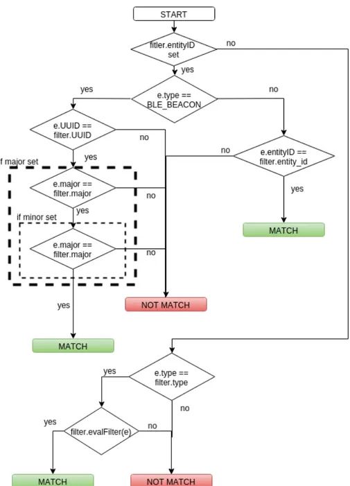
Up to this point, ADPF is connected to network and is scanning for BLE beacons. Every time it scans, it updates the list of last beacons seen and verifies if some of them matches some proximity or geofence subscription: for every match, it fires the corresponding event.
Furthermore, after a fixed number of scans, the framework broadcasts a mes-sage (PROX BEACONS mesmes-sage) with the list of last detected beacons and the computed DistanceRange (see section 3.5.3) for each of them, that is used by other devices to find out if they are in proximity.
Proximity computation
When a PROX BEACONS message is received from another device, ADPF com-pares message beacons with the last detected ones by selfEntity: if at least one is in common, and corresponding DistanceRanges are useful (see section 4.2.7), the framework is able to say that selfEntity and the message sender are in proximity: so, it sends to message sender a PROXIMITY UPDATE message, containing information about that computed proximity.
If instead ADPF has sent a PROX BEACONS message and has received a cor-responding PROXIMITY UPDATE message by someone, let’s say Entity E, it
checks if there’s some proximity or geofence subscription between selfEntity and a group containing E, and for each matching subscription it fires the corresponding event.
In figure 3.2 is shown proximity computation with a simplified schema, in order to better understand the aforementioned process.
Figure 3.2: Proximity computation
Properties update
At a certain point, an Entity can decide to update its properties (see section 3.5.1); in this case, framework has to communicate this change to other entities, because an update of properties could mean a group leave/join. For example, if a user wants to change his interests from “comic movies” to “action movies”, he is leaving the Group defined by entities interested in comic movies, and joining the Group defined by entities interested in action movies.
Then, a properties change is followed by a PROPERTIES UPDATE message send-ing, containing selfEntity information, old and new properties. When a similar message is received, ADPF checks if there is some group subscription with a
Group matching old or new properties, and in that case it fires the correspond-ing group join/leave event.