Geographies of the Anthropocene
Open Access and Peer-Reviewed series
Editor-In-Chief: Francesco De Pascale (CNR – Research Institute for
Geo-Hydrological Protection, Italy).
Co-Editors: Marcello Bernardo (Department of Culture, Education and
Society, University of Calabria, Italy); Charles Travis (School of Histories and Humanities, Trinity College Dublin; University of Texas, Arlington).
Editorial Board: Mohamed Abioui (Ibn Zohr University, Morocco), Andrea
Cerase (Sapienza University of Rome, Italy), Valeria Dattilo (University of Calabria, Italy), Chair, Dante Di Matteo (Polytechnic University of Milan, Italy); Jonathan Gómez Cantero (University of Alicante, Spain; Young Scientists Club, IAPG), Nguvulu Chris Kalenge (University School for Advanced Studies IUSS Pavia, Italy), Battista Liserre (Aix-Marseille University, Campus ESSCA, France), Giovanni Messina (University of Palermo, Italy), Gaetano Sabato (University of Catania, Italy), Carmine Vacca (University of Calabria, Italy).
International Scientific Board: Marie-Theres Albert (UNESCO Chair in
Heritage Studies, University of Cottbus-Senftenberg, Germany), David Alexander (University College London, England), Loredana Antronico (CNR – Research Institute for Geo-Hydrological Protection, Italy), Lina Maria Calandra (University of L’Aquila, Italy); Salvatore Cannizzaro (University of Catania, Italy), Fabio Carnelli ((Polytechnic University of Milan, Italy); Carlo Colloca (University of Catania, Italy), Gian Luigi Corinto (University of Macerata, Italy); Roberto Coscarelli (CNR – Research Institute for Geo-Hydrological Protection, Italy), Sebastiano D’Amico (University of Malta, Malta), Armida de La Garza (University College Cork, Ireland), Elena
Dell’Agnese (University of Milano-Bicocca, Italy; Vice President of IGU), Piero Farabollini (University of Camerino, Italy), Giuseppe Forino (University of Newcastle, Australia), Virginia García Acosta (Centro de Investigaciones y Estudios Superiores en Antropología Social, CIESAS, México); Cristiano Giorda (University of Turin, Italy), Giovanni Gugg (University of Naples “Federico II”, Italy, University of Nice Sophia Antipolis, France), Luca Jourdan (University of Bologna, Italy), Francesca Romana Lugeri (ISPRA, University of Camerino, Italy), Fausto Marincioni (Marche Polytechnic University, Italy), Cary J. Mock (University of South Carolina, U.S.A.; Member of IGU Commission on Hazard and Risk), Francesco Muto (University of Calabria, Italy), Gilberto Pambianchi (University of Camerino, Italy; President of the Italian Association of Physical Geography and Geomorphology), Silvia Peppoloni (Istituto Nazionale di Geofisica e Vulcanologia, Italy; Secretary General of IAPG; Councillor of IUGS), Isabel Maria Cogumbreiro Estrela Rego (University of the Azores, Portugal), Andrea Riggio (University of Cassino and Southern Lazio, Italy; President of the Association of Italian Geographers), Bruno Vecchio (University of Florence, Italy), Masumi Zaiki (Seikei University, Japan; Secretary of IGU Commission on Hazard and Risk).
Editorial Assistant, Graphic Project and Layout Design: Franco A.
Bilotta;
Website: www.ilsileno.it/geographiesoftheanthropocene;
The book series “Geographies of the Anthropocene” edited by Association for Scientific Promotion “Il Sileno” (Il Sileno Edizioni) will discuss the new processes of the Anthropocene epoch through the various worldviews of geoscientists and humanists, intersecting disciplines of Geosciences, Geography, Geoethics, Philosophy, Socio-Anthropology, Sociology of Environment and Territory, Psychology, Economics, Environmental Humanities and cognate disciplines.
Geoethics focuses on how scientists (natural and social), arts and humanities scholars working in tandem can become more aware of their ethical responsibilities to guide society on matters related to public safety in the face of natural hazards, sustainable use of resources, climate change and protection of the environment. Furthermore, the integrated and multiple perspectives of the Environmental Humanities, can help to more fully understand the cultures of, and the cultures which frame the Anthropocene. Indeed, the focus of
Geoethics and Environmental Humanities research, that is, the analysis of the way humans think and act for the purpose of advising and suggesting appropriate behaviors where human activities interact with the geosphere, is dialectically linked to the complex concept of Anthropocene.
The book series “Geographies of the Anthropocene” publishes online volumes, both collective volumes and monographs, which are set in the perspective of providing reflections, work materials and experimentation in the fields of research and education about the new geographies of the Anthropocene.
“Geographies of the Anthropocene” encourages proposals that address one or more themes, including case studies, but welcome all volumes related to the interdisciplinary context of the Anthropocene. Published volumes are subject to a review process (double blind peer
review) to ensure their scientific rigor.
The volume proposals can be presented in English, Italian, French or Spanish. The choice of digital Open Access format is coherent with the flexible structure of the series, in order to facilitate the direct accessibility and usability by both authors and readers.
EARTHQUAKE RISK PERCEPTION,
COMMUNICATION AND
MITIGATION STRATEGIES ACROSS
EUROPE
Piero Farabollini
Francesca Romana Lugeri
Silvia Mugnano
Editors
6
CONTENTS
Preface 8
Introduction 12
Section I
Mitigation Strategies of Seismic Risk
1. Urban Seismic Risk Reduction and Mitigation Strategies in Turkey
Ahmet Anıl Dindar, Cüneyt Tüzün and Aybige Akinci 19
2. A Collection of Statistical Methods for Analysis of the Disaster Damages and the Seismic Regime
Vladilen Pisarenko, Mikhail V. Rodkin 43
3. Turkey’s Earthquake History and Institution Based Earthquake Reduction Policies and Strategies
Alper Uzun, Burak Oğlakci 64
4. Risk Mitigation through Local Building Knowledge: Turkish Van Region Case Study
Chiara Braucher, Mattia Giandomenici 84
Section II
Communication and Prevention Strategies of Seismic Risk
5. Communication-Based Prevention Strategies: A Draft Model Proposal
Andrea Volterrani 105
6. Geoscientists’ Voice in the Media: Framing Earth Science in the Aftermath of Emilia 2012 and Amatrice 2016 Seismic Crises
Andrea Cerase 123
7. The 2016 Earthquake in Central Italy. The Alphabet of Reconstruction
7
8. Food Management in Disasters: the Case Study of the Earthquakes of 24 August 2016 in Central Italy
Fausto Marincioni, Eleonora Gioia, Mirco Zoppi,
Elena Vittadini 172
Section III
Resilience and Post-Disaster Recovery
9. An Historical Flight and Some Open Questions towards a Pluralistic but Holistic View of Resilience
Maurizio Indirli 194
10. Earthquakes and Society: the 2016 Central Italy Reverse Seismic Sequence
Piero Farabollini, Serafino Angelini, Massimiliano Fazzini, Francesca Romana Lugeri, Gianni Scalella,
GeomorphoLab 249
11. Second Home Holidays Makers Recovery After a Disaster: Insights from the 2016 Central Italy Earthquake
Silvia Mugnano, Fabio Carnelli, Sara Zizzari 267
12. Assessing Resilience of Mountain Communities Hit By The Central Italy Earthquakes of 2016
Teresa Carone, Giulio Burattini, Fausto Marincioni 285
145
7. The 2016 Earthquake in Central Italy. The alphabet of
reconstruction
Piero Farabollini1
Abstract
The proposed paper tries to take stock of the post sisma situation, three years after the central Italy earthquake, highlighting procedural problems and suggesting desirable improvements to the legislation governing reconstruction. The objective is to provide a complete scheme of the complex institutional process related to the problem of the post seismic reconstruction, by combining differents kind of informations: scientific, technical, regulatory and institutional.
The following pages aim at illustrating, through a sort of alphabet (where, however, some letters are missing, since the reconstruction path is not completed) the activity of the commissioner, the legislative and financial system and the route, with the relative rules to reach the objectives, necessary to give society the due guarantees. Such a great operation needs collaboration, sharing, intelligence, foresight and the will of everyone. And above all, it needs trust!
Keywords: Earthquakes, Society, Reconstruction, Commissioner,
Communication
1. Introduction
On 24 August 2016, a magnitude 6.0 earthquake struck central Italy, with its epicenter located on the border between the regions of Lazio, Marche, Abruzzo and Umbria, near the built-up area of Accumoli (Rieti, Lazio). On 26 and 30 October 2016 and 18 January 2017, four major seismic events occurred again, respectively of 5.7M, 5.9M, 6.5M and 5.7M, which extended the area affected by the sequence seismic, which corresponds to about 2000
1 Corresponding Author; Extraordinary Government Commissioner for the reconstruction
in the earthquakes areas of the 2016 and 2017; Scuola di Scienze e Tecnologie, Sezione di Geologia, Università degli Studi di Camerino, Via Gentile da Varano, 1, 62032 Camerino (MC); e-mail: [email protected].
146
km2. The geological data relating to the surface effects detected immediately after the seismic events, as well as the numerous geophysical data available (accelerometric data, radar interferometry and GPS), all agree in attributing the genesis of the 2016 seismic events to the faults system of Monte Vettore-Monte Bove, consisting of several segments of normal and / or transtensive faults, which extends for about 30 kilometers in the NO-SE direction.(Aringoli et al., 2016, 2018).
On 25 August 2016, the Council of Ministers, with its own resolution, declared a state of emergency, entrusting to the Civil Protection Department the coordination of the activities of this first emergency phase (which was managed by Di.Coma.C - Directorate for command and control, established in Rieti, with the Civil Protection Order dated August 26th) specifying that, at the end of the emergency phase, the Regions would ordinarily coordinate the interventions aimed to overcome this phase. In this way the Presidency of the Council of Ministers had specified that the management of the emergency phase was entrusted to the Department of Civil Protection, through the institution of the Di.Coma.C, that therefore was activated for the aspects of immediate support to the population and to the productive activities, while the management of the reconstruction phase was entrusted to a Special Government Commissioner, who was to provide for the implementation of the post-earthquake reconstruction phase (Valeriani & Bertelli, 2017). Subsequently, on 9 September 2016, after having recognized the complexity of the situation faced by the territories, the President of the Republic, by his own decree, appointed Vasco Errani (the former extraordinary commissioner for the Emilia earthquake 2012) as extraordinary commissioner of the Government for the reconstruction in the territories of the Municipalities of Abruzzo, Lazio, Marche and Umbria affected by the seismic event of 24 August 2016, and subsequently the Hon. Paola De Micheli (since September 2019 Minister for infrastructures). On 5 October the new government appointed Prof. Geol. Piero Farabollini as extraordinary commissioner for the reconstruction of the areas devastated by the 2016 earthquake.
It should be underlined how the extraordinary commissioner for post-earthquake reconstruction is in charge of reconstruction either, and therefore, only intervenes after the emergency phase. In this point of view, the structure of the Commissioner has no competences over what has already begun in the emergency phase, which passes through acts, actions, ordinances and proposed norms that instead fall within the competences of the National Civil Protection, until the emergency regime is in force, extended until 31 December 2019 (eg: SAE - Emergency Housing Solutions; CAS -
147
Autonomous Accommodation Contribution; Management of the Rubble Plan; etc.).
The content of this paper intends to explain a series of complex situation involving multiple subjects and refer to contexts in condition of continuous and often dramatic transformations. It is complex operation even the component description that concur to the characterization the action field of what is the management of post-seismic reconstruction. Combining informations of different nature is fundamental; scientific, technical, normative and institutional. To that end, was chosen to face up various themes using an “encyclopedic” approach, with a neo-illuministic soul. Maybe an unusual style for an article but certainly effective to clear up to the audience many realities not easy to understand. Even the bibliography is inserted as consulted, avoiding text references thanks to the approach followed in the setting.
The pages that follow want to illustrate, through a sort of alphabet (where, however, some letters are missing, being the reconstruction path not completed) the activity of the commissioner, the legislative and financial system and the route - with the relative rules to reach the objectives - necessary to give guarantees and trust, because a great operation like this needs collaboration, sharing, intelligence, foresight and the will of everyone. And above all of trust!
148
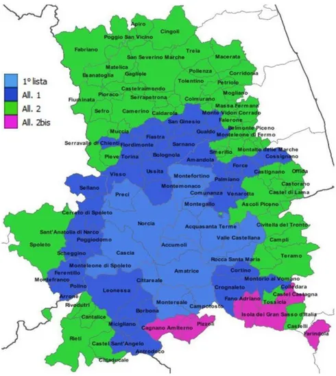
Figure 1 – Area and municipalities into the so called “seismic crater”. 2. Alphabet (uncompleted) of reconstruction
The seismic events of summer-autumn 2016 in central Italy, caused numerous victims and damages, showing once again the inability to effectively reduce the seismic risk in our country and associating these difficulties with problems relating to risk awareness by administrators and citizens, the availability of funds and engineering techniques suitable depending on the context in which they are applied (Cheema et al., 2016) (Valensise, 2018). The resulting need is a careful reflection on the different
149
aspects that are important from a social and economic point of view of the cost of catastrophes (in particular of the seismic events which, as we know, are unpredictable, but which can be estimated in terms of maximum expected magnitude and hazard zoning): regulatory, scientific-technical and urban planning tools currently in use to prevent earthquakes, information and communication of danger and risk; resilience and cohabitation with natural dangers. If we want to avoid the same post seismic scenario in 2016 from happening again in the near future, we need to develop an advanced assessment of the seismic hazard, of coordinated emergency and post-emergency interventions and of the re-establishment of the social structure economic and cultural impact of the territory in order to guarantee the quality of the reconstruction and management of the geological security of the territory. It should be noted, however, that following the seismic events that began on 24 August 2016, a conscious and participatory moving of several thousand people from the areas of the so-called "crater" towards the coastal area. The result has been a gradual depopulation of mountain areas, which has already been underway for several years, which has resulted in a "forced exodus" (both to the need of avoid hazards, and to the emergencial instructions) especially with regard to those who would never have abandoned the mountain territory, due to the strong loyalty of the older people to native places. Currently we are witnessing an impoverishment of the population, especially the younger one, from the mountain areas, with consequent overcrowding of the destination areas that do not have the means, resources and ability to guarantee adequate services to the new, unexpected, unplanned demographic impulse.
A as: AeDes, FAST, sworn studies
After the first strong earthquake of 24 August, the usability checks, through the AeDes procedures (Suitability and Damage in seismic emergency, updated with the DPCM. 8 July 2014) and Fast (Italian acronym for Buildings for post-Earthquake Synthetic Compliance with safety standards), activated , the latter, after the seismic events of 26 and 30 October, with data provided by the Civil Protection department and compared with those provided by the USR (and updated to 31 December 2017), report 110,724 usability inspections carried out in Marche, Umbria, Lazio and Abruzzo, all central Italian regions. Out of 43,853 private buildings, 45% were fit for use, to which approximately 10% of buildings that are not damaged but are unusable due to external risk are added, while 35% was
150
declared unfit for use and the remaining had partial or temporary results unavailability.
The checks (still) have not been completed, also because following the events of the end of October, the viability verification procedure has changed. In fact, in private reconstruction, the post-earthquake usability checks carried out through the AeDES board were carried out on those buildings that were declared unusable, following the so-called FAST verification aimed at selecting buildings available respect to those that could not be used immediately. The private individuals, therefore, owners of damaged buildings and in possession of the requisites necessary to request the contribution for reconstruction, must appoint the professionals to the compilation of the AeDES forms, on the basis of the results of the "fast" pprocedures so-called FAST. The professional who drafted the FAST form, cannot also complete the AeDES form for the same building.
B as: Beni Culturali (cultural heritage and churches)
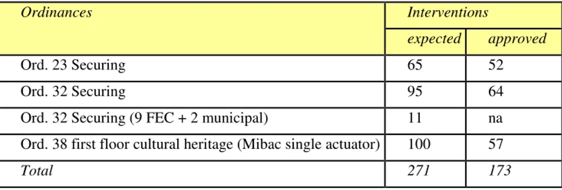
As part of the "Church Program" (Ordinances 23 of 05/05/2017; Ordinance 32 of 22/06/2017; Ordinance No. 38 of 08/09/2017), the commissioner, the MiBAC (Cultural Heritage and Activities and Tourism), and the Dioceses activated themselves to restore the usability of an invaluable identity heritage. For central Apennines places of worship, from the typical “porziuncole” (old and small country churches) to the cathedrals, from the road icons to the abbeys, not only represent cultural roots, but certainly an important tool of economic recovery. To date, the budget for the actions of the commissioner is certainly positive: around 64% of the provided interventions by the ordinances have been approved or realized (ISTAT, 2016).
Table 1 – Ordinances and interventions expected and approved.
Ordinances Interventions
expected approved
Ord. 23 Securing 65 52
Ord. 32 Securing 95 64
Ord. 32 Securing (9 FEC + 2 municipal) 11 na Ord. 38 first floor cultural heritage (Mibac single actuator) 100 57
151
The churches related to Ordinance n. 38 are 100, for a total expected amount of € 170.600.000 and the actuator subject is, pursuant to the Ordinance itself (and the memorandum of understanding between the Extraordinary Commissioner, the MiBAC and the Italian Episcopal Conference), the MiBAC. Following the amendment to article 15 paragraph 3 of Legislative Decree 189/2016 made with the so-called Genoa Decree (D.L.109 / 2018 of 28 September 2018), the dioceses can currently act as actuator subjects. Through the so-called "Table of the Consulta", composed of representatives of the CEI, (Italian Episcopal Council) the MiBAC and the structure of the extraordinary Commissioner, the technical table was launched to support the regularity of the implementation of this activity, which provides for streamlined methods for the reconstruction of churches with amount of works less than € 600.000.
C as: Citizens (active participation of citizens to reconstruction)
Hand in hand with the extreme lacunae of exhaustive documentary sources with correct data and in real time, it is necessary to think about the commissioner structure as a sort of cultural mediator as well as reconstruction financier, which has the opportunity to cooperate and coordinate with stakeholders. Starting a less mediatic and more operational management of the relationships with the different actors of the reconstruction, rather than financial and media performances, obliges to normative interventions to turn towards the reconstruction on the spot rather than on the paper and on the social networks through the realization of a dense network of meetings and contacts aimed at strengthening the relationship between reconstruction and its stakeholders, primarily all mayors and representatives of the institutions in the territories, professional networks, productive activities, universities.
Organizing meetings with the representatives of all the earthquake-stricken citizens committees, is substantial and effective when it is possible to express not only one's own requests, but also the vision of the status quo and future prospects, so as to allow a precious confrontation not only from the human and dialectical point of view, but also technical. However, it should be underlined that there are those who (fortunately very few) have “preferred” to use their representation in a Committee (Ordinance No. 36 of 08/09/2017) to campaign and / or to make personal advertising by giving knowledge and skills that the other members do not recognize and, however, assuming roles, in accordance with the law, which do not belong to them and rising to the role of coordinator or else only for their own self-referential
152
needs, sometimes confusing skills and roles that belong to the Government rather that to the Civil Protection or the Extraordinary Commissioner (CAS, SAE, urban free zone, small discrepancies, taxation, extension of the suspension of utilities, heavy paychecks, etc.). It is also inevitable to underline that in some (very rare)case, it happens, by people belonging to the Committees (Ordinance No,36 of the 09/08/2017)a sort of autonomous and improper acquisition of roles and competences, normally due to Government, the Civil ¼Protection or the Special Commissioner (CAS, SAE,urban free zone,small discrepancies, taxation,extension of the suspension of utilities,etc.), Unfortunately, this phenomenon occurs with recurrence (in our as in other countries) in the case of a vast and complex emergency situation. Obviously this aspect strongly altered the balance of a reconstruction that had (and always should) be characterized by speed, efficiency,neutrality and security, also from the point of view of adaptation to the return times of future seismic events
D as: DURC (Document of Regular Contribution Congruity)
Order 58, issued by the Special Commissioner for Reconstruction, provides for new legislation regarding transparency in post-earthquake reconstruction operations for professionals and businesses. The companies that have carried out the reconstruction interventions are asked, in addition to the that certifies the regular contributions (DURC on line), also the congruity DURC, or the document that is provided by the competent Cassa Edile and which proves the adequacy of the incidence of the workforce used by the company to carry out the work in relation to the amount of works to be performed or already performed. Document also envisaged in private reconstruction works that receive grants exceeding 50 thousand euros. When the project progress status and final status are presented, the cost and incidence of labor must be calculated based on the criteria indicated in Annex 2 of the Ordinance itself.
E as co-seismic Geological Effect
Immediately after the main event on 24 August 2016, in addition to the immediate starting of the Civil Protection activities, were carried out by numerous researchers of research institutes and state universities checks on the environmental effects of the earthquake, linked to the reactivation of the active tectonic elements as well as secondary effects related to the main
153
shock.
The direct effects are related to the deformation of the soil at the fault, whose rift has generated the seismic event and the effects are limited to an area that is not very extensive and close to breaking. The secondary effects, resulting from the temporary passage of seismic waves, have also been recognized very far from the epicenters, and have caused a widespread presence of permanent effects on the earth's surface which, in relation to the length of the fault and the magnitude released by the event, have been evaluated in order of thousands of km2. More than 5000 evidences have been collected that have allowed to build a database on the effects of the earthquake distinguished,as already said, in direct effects and secondary effects: ground fractures, activation and reactivation of large landslides and DGPV (slope deep gravitational deformations), rock collapses and / or debris avalanches, avalanches, collapse of sinkholes, mud volcanoes and liquefaction phenomena, Barrage due to landslides, differential settlement, changes in the water regime of the springs and the flow of the rivers, cracks and / or fractures and / or deformations on road and network infrastructures, etc (Civico et al., 2018) (Farabollini et al., 2017) (Farabollini et al., 2018).
The analysis of the numerous evidences found in the area of the so-called "crater", has allowed us to estimate how about 70% of the effects found are attributable to fractures and co-seismic cracking; that 8% are due to landslides s.l. and to deformations, while about 20% to failure of road and network infrastructures and the remaining 2% to failure, variations in the water regime and other minor causes (EMERGEO, 2016).
In addition to the purely geostructural aspect, linked to seismogenic faults, it is necessary to take into consideration the geomorphological effect on the environment and on damage, trying to verify and above all quantify the role of some elements that characterize the central Apennine territory (and in particular the role played by large landslides in the state of quiescence or DGPV), in determining effects of local amplification both in bedrock and in continental Quaternary deposits. Thus, based on the effects on the ground and on the damage to the buildings, it would also be possible to effectively locate the epicenter areas, especially for those seismic zone defined only by historical data.
F as FAC (Active and Capable Fault)
Many historical earthquakes have had catastrophic effects (1693 in eastern Sicily, 1783 in Calabria, 1805 in Molise, 1908 in Messina, 1915 in Fucino,
154
1968 in Belice; 1980 in Irpinia, 1997-98 in Umbria and Marche, 2009 in L'Aquila) reaching Magnitude close to or above 7.
Paleoseismological studies have allowed us to characterize the faults responsible for many of these earthquakes, demonstrating that late Pleistocene-Holocene dislocations have affected many structures considered, in the past, completely inactive (Aringoli et al., 2016). For Active and Capable Fault (FAC) therefore means that fault for which there is evidence of repeated reactivation, with breaking of the topographic surface in the last 40,000 years (Olocene-upper part of the Upper Pleistocene) (Coltorti & Farabollini, 2002) (Pierantoni et al., 2013) (Tondi & Cello, 2003).
Generally, this definition refers to the main fault breaking plan. The earthquake of 24 August 2016, from the first INGV analysis based on only GPS stations active at the time of the earthquake, was generated by a fault more than 18 km long and inclined about 50 degrees, which it runs north-northwest-south-southeast and plunges towards west below the Apennines. The movement of this fault, caused an extension of the Apennine chain of about 3-4 centimeters between the Tyrrhenian and the Adriatic. The identification of active and capable faults, is almost always connected to the different scientific currents and problems which emerge in all international academies, and so subject to different interpretations, usually with drastic effects on the work quality as serious errors of evaluation of the real seismogenic potential. Through the studies of seismic microzonation level 3, using the Addresses and Criteria for the Seismic Microzonation (MS Working Group, 2008) (Aringoli et Alii 2018), the danger from surface faulting is treated through the identification of a zone of respect of 15 + 15 m in the case of active and capable fault, and of 75 + 75 m for an active and incapable fault. It follows that the legislation on post-earthquake reconstruction (DL 189/2016) and the extraordinary commissioner's ordinances (Ordinance 25, Ordinance 39 and Ordinance 46), govern the uses of the land in active and capable fault zones, both from the point from an urbanistic point of view, that from the point of view of the use classes of the manufactured articles.
I as a risk Information and communication
It is one of the most important issues, strategic and delicate, intended both as an awareness tool for the occurring events and for the knowledge of related problems (Calzolari, 2018; Lombardi, 2005). The geographic and geomorphological structure of Italian country requires - avoiding further delays - the start of new strategies, based on a complete, and scientifically
155
valid knowledge. The divulgation is essential: the prevention is necessarily based on those cognitive processes that activate conscious knowledge in society, necessary to face - or even better avoid - emergency situations, thanks to a progressive development of virtuous practices. The experiences carried out up until now, have largely confirmed the social need for a correct information, and underlined as well the broad spectrum utility of those innovative initiatives that have been undertaken (Farabollini et al. 2014). The themes belonging to popular culture, revealed a great validity if used as vector of information: it is finally clear the fundamental function of structured scientific communication programs, addressing a broad and composite audience. New codes, agile dialogic systems, flexible rhythms and operational autonomy: these are the characteristics necessary to start new communication strategies aimed at reaching a social education towards risk prevention. This is the new challenge of the research world (finally integrating itself with the communication one): to introduce the public to the characteristics of our country, making people able to recognizing its quality and vulnerability, as well as the Italian landscape’s resources and risks (Farabollini et al., 2018) (Lugeri et al., 2018). Not to be forgotten is the geological mapping, a territorial analysis tool that is extremely valid also in sharing knowledge, thanks to the new methods of representation through Geographical Information Systems, which allow an integrated use of information and images, at different degrees of complexity, comprehensible to different ranges of users, at different levels of complexity.
M as Macerie (Rubble)
With the order of the Head of Department n. 391 of 1st September 2016, the Regions are assigned, which can make use of municipalities aid, the collection, transport in temporary storage, the recovery or disposal of materials deriving from collapses and from demolition of unsafe buildings. In the rubble management process, the remains of assets of historical and cultural interest, are managed with a dedicated procedure, selected and separated at the origin according to the indications of the MIBAC (Ministry of Cultural Heritage and Activities and Tourism), thanks to the support of specialized civil protection volunteers. In the same way, the management of asbestos-containing material is specifically regulated.
According to the Ordinance of the National Civil Protection Department n. 495 of 4 January 2018: ".... omissis .... 100 million, from the resources of the Solidarity Fund of the European Union, are assigned, by way of
156
anticipation, to the Regions affected by the seismic events mentioned in the introduction , in proportion to the total estimate of the rubble of the same, and converge into the respective special accounts in order to guarantee the continuation, without interruption, of the activities referred to in art. 28, paragraph 4 of law decree, 17 October 2016, n. 189, .... omissis ”.
With letter prot. 63079 of 5 November 2018, the National Civil Protection Department announced that the regulation dictated by the Implementation Regulation of the European Union Solidarity Fund (EUSF), provided the use of the financial contribution within 18 months from the date of payment of the contribution by the Commission, specifying that 6 May 2019 would be the deadline by which expenses must be paid to be considered eligible.
At present the Regions:
- they have not completed the removal of the rubble;
- they have not completed the use of the funds disbursed pursuant to ODPCN 495 of 04 January 2018, whose reporting must be made until 6 May at risk of losing the residual fund;
- they used different awarding procedures (in some cases also through direct assignment, also for amounts above the threshold for which a board question was asked);
- they used costs for removal not in line with ODPCN n.495 dated 4 January 2018.
Table 2 - Rubble removal.
Region Estimated Rubble (Tons) Fund Redistribution ODPCN N.59 04.01.2018 % Funds Average Cost(€) a Ton (ODPC N n.59) Cost paid by the single region Total real rubble Rubble removed Further needs (request Regions) Report on 10.03.2019 (from DPCN) Abruzzo 160.000 6.037.528,52 6 37,71 91,20 106.337,67 45.780,48 3.660.557,7 4.189.821,28 Lazio 1.287.000 48.564.370,05 48 37,71 60,00 1.170.000, 00 950.000,0 0 30.000.000,0 21.064.860,21 Marche 1.103.091 41.624.646,10 42 37,71 59,00 1.079.705 ,42 615.718,4 3 19.516.150,0 21.064.860,21 Umbria 100.000 3.773.455,33 4 37,71 66,00 153.000,00 100.000,0 0 6.600.000,00 2.383.205,97 Total 2.650.091 100.000.000,00 59.776.707,7 48.702.747,67
157
M as Sisma 2016 reconstruction Model
At the beginning of October 2018, more than two years after the first shock of the most devastating earthquake that Italy remembers after Irpinia, the balance of what has been done for reconstruction has been objectively less despite the huge resources available. Many technicians had repeatedly invited the commissioner to review a model of reconstruction whose functional inadequacy was already evident. In a first phase, it was decided to adopt the reconstruction model used in Emilia Romagna for the 2012 earthquake. But the territorial situation in the mountainous-hilly areas of the central Apennines, thick of historical villages, showed the clear need to take into account the different complex natural and cultural structures of the areas. Where historical monuments stood or a traditional agricultural landscape element were established, often in case of recovery a territorial enhancement purposes (widespread hotels or niche agribusiness companies), is not possible to move as in case of wide plains, dense of industrial sheds and terraced houses.
Only as an example of how the distance between the two models was substantial, is it to be noted that the wall masonry was not considered in the calculation of volumes, typical of most of the structures of this Apennine belt. Such a model, maybe, would have succeeded, even with difficulty, in some way to bear fruit, if the restricted area of the first so-called seismic crater (an Italian way to define the spatial extent of the area damaged by the earthquake) result of the shocks of August 2016, had not spread out of proportion after the great shock in October 2016 and that of January 2017. To the four municipalities that initially formed the crater (Accumoli and Amatrice nel Lazio, Arquata del Tronto and Montegallo in the Marche), others 134 have been added between Abruzzo, Lazio, Marche, Umbria. An area that is not only vast, but so heterogeneous due to its physiographic, building-town planning, landscape and socio-economic characteristics, that it requires an immediate change of vision (Lanzini, 2018).
Unfortunately also the following phase seemed more interlocutory than decision-making and propositional and, although it led to the production of various ordinances, nevertheless left procedural doubts and, in some cases, even overlaps and ample faculties of interpretation of the same. The result is that the need to "speed up" the reconstruction, cannot be separated from the need to substantiate the strategic vision for a new and more profitable approach to the procedures and related processes not only by the Commissioner, but by the legislator himself.
158
Certainly the will (of the Government in office at the time of 2016 seismic events) of not wanting to pass, through the instrument of a "special law", led to the obligation to use ordinary regulatory instruments that often involved slowing down, overlapping and different interpretations on procedures used and usable in both public and private reconstruction, forcing the Commissioner to request regulatory action notwithstanding Legislative Decree 189/2016 through proposed amendments, a method that has never been addressed previously, although were obvious the symptoms of a cumbersome reconstruction and sometimes directed to follow up more "political" than strategic, therefore failing in the ask of giving concrete answers to citizenship. Furthermore, the willingness of previous governments not to want to differentiate the area affected by the seismic sequence that began on 24 August 2016 and continued with the additional earthquakes of 26 and 30 October 2016, from that of 18 January 2017, identifying two craters with differentiation of the degree of damage , entailed that the reconstruction in the 138 municipalities is carried out with homogeneous and coordinated criteria throughout the crater area, in accordance with Law Decree 189/2016. At present, considering that in any case the ordinances take into account a single crater, it follows that dividing the crater into two or more areas on the basis of the different degree of damage, although methodologically appropriate would lead to further delays and inconveniences and discontinuities that cannot be justified.
M as MZS (Seismic Microzonation)
The seismic events that have affected central Italy from 24 August 2016, also due to such a vast extension of the phenomenon on the territory, have shown unequivocally how the degree of damage has been strongly conditioned by the geological features s.l. of the territory involved. The result was the need to operate in a systematic way through studies of seismic microzonation as a tool for the prevention and mitigation of seismic risk. Italy, in fact, is the only country in the world that, in ordinary time, plans and carries out seismic micro-zoning throughout the national territory, with specially regulated methods of execution, entrusting studies to professional technicians that share in all the Regions the same criteria and standard executions.
Seismic microzonation can be done according to three study levels, depending on the purpose of the studies and the complexity of local situations: A- Seismic microzonation of level 1, in which the homogeneous areas are
159
identified in seismic perspective, identifying the areas susceptible to local effects and the type of expected effects: a map is produced that distinguishes the zones in stable, stable zones with amplifications and unstable zones;
B- Seismic microzonation of levels 2 and 3, which allows to elaborate on the level of knowledge with respect to level 1 microzonation, associating to the homogeneous zones a numerical quantification of the amplification of seismic motion. The distinction between the two levels is linked to the possibility of adopting simplified assessments in non-complex geological situations (level 2), respect to the needs to carry out specific numerical analysis of local seismic response (level 3).
The different levels of seismic microzonation can be applied to territory planning and emergencies, and to be supportive to the planning of interventions on the artifacts.
M as MUDE
The MUDE (SINGLE DIGITAL MODEL for BUILDING-platform for monitoring the reconstruction) is the request service of contribution for reconstruction and contextual dispatch of the qualifying building permit title, management of the progress of the work and establishment of an informatic file courtesy of the requests and actions of intervention .The tool was born within Piemonte region and the Municipality of Turin as part of an innovation project financed with ministerial funds of the year 2009 Program ELISA (Local Authorities - System Innovation) of the Presidency of the Council, and which saw as promoters also Emilia-Romagna region, Umbria region, Municipality of Padua, Municipality of Rome, Municipality of Bologna and Municipality of Modena.
It is therefore an application with all the pros and cons of a mature platform: it is widely disseminated and known by professionals so as not to be a further criticality but at the same time it suffers the weight of a technology that requires expensive configurations in the computers of professional. Furthermore, the platform is born with a vocation to control the data already in the compilation phase so as to simplify the preliminary activities, something sometimes perceived by professionals as "difficult".
Through the DNS management panel the sub-domains have been set, all addressed to the same IP address, as follows:
• sisma2016.gov.it
• anagrafe.sisma2016.gov.it • assistenza.sisma2016.gov.it
160
• intranet.sisma2016.gov.it • oopp.sisma2016.gov.it
• professionals.sisma2016.gov.it • scuola.sisma2016.gov.it
However, this platform, as already said, presents some critical issues which, for purely technical reason, appear to be less "convenient":
* it is only supported by Internet Explorer, a now obsolete browser because for years it has not been updated by Microsoft, which replaced it with its new Edge browser
* does not allow the correction or replacement of cards and documents quickly and effectively during the loading phase, forcing long and unsuccessful sessions even the most expert technicians, who have had to register a data loss in conjunction with the deadlines for the 2018 terms of submission in the course of the maintenance / adaptation procedure to the legislation activated by the CSI Piemonte supplier
* the USR (special reconstruction offices) acquire the documents on MUDE, but carry out the entire procedural process on their own platform (also specifically created as in the case of the Marche), with difficulties in dialogue between the two systems.
The commissioning structure therefore does not directly have access the complete data for process monitoring and, above all, has incomplete data that requires a long data cleaning job. Through the MUDE, the control over the workflow of private reconstruction and productive activities can only be carried out in a very small part, in some cases making it inadequate to carry out that action of monitoring the interventions provided for by the Legislative Decree 189/2016, making it necessary to start the development of integrative tools and procedures summarized by a flexible, integrable and easily questionable platform.
N as Centro-Italia Earthquake 2016 Numbers
Thousands of earthquakes in just over three months, four regions (Abruzzo, Umbria, Marche and Lazio) affected by a seismic sequence started on 24 August 2016 that devastated the countries along the border between the same regions. The experts count over 20 thousand events of magnitude equal to or greater than 3.
According to the experts of the National Research Council (CNR) and of the National Institute of Geophysics and Volcanology (INGV), the three main shocks (24 August 2016; 26 and 30 October 2016) have created significant
161
ground deformations. In particular, at Accumoli the earth has dropped by 20 centimeters, in Castelsantangelo sul Nera 18 centimeters while in Norcia about 70 centimeters.
Excluding the 63-year-old from Tolentino who died of a heart attack, the three earthquakes in central Italy killed 298 people, all victims of the August 24 shock.
Civil protection has 17,000 people assisted, including: 4.700 left in their own country,
9.400 lodged in hotels along the Adriatic coast and Lake Trasimeno, 2.900 in accommodation facilities spread over the territory, 326 in tents.
The Ministry of Defense has sent 450 soldiers from the Safe Roads Operation to guard the homes of the displaced of the 62 municipalities involved.
Following the seismic events, more than 870 emergency housing solutions (SAE) were provided to the inhabitants of the countries most affected by the earthquake, including, for example, 181 in Accumoli, 459 in Amatrice, 68 in Norcia and 170 in Arquata del Tronto.
According to an estimate of the ANCI (National Association of Italian Municipalities), there are about 200 thousand buildings damaged or unusable in the areas of central Italy affected by the earthquake. The areas devastated by the earthquake have about 3,000 heavily compromised farms and about 50 damaged stables.
According to the analysis carried out in collaboration with the Ministry of Cultural Heritage and Tourism, damages to cultural heritage amounted to over 541 million euros (over five thousand reports received by the Ministry of Cultural Heritage for damage to the artistic heritage); more than 22 thousand works of art have been recovered and more than 15 thousand books, while archival assets exceed 5 thousand linear meters (http://www.beniculturali.it/mibac). Subsequently the earthquake in central Italy in 2016, the damage exceeds € 23 billion and € 530 million, of which € 12.9 billion refers to damages relating to private buildings and € 1.1 billion to public buildings. The estimate includes direct damages, both public and private (those that have caused the destruction of buildings, infrastructures, crops and even those that have affected industries and businesses, cultural heritage, energy distribution networks, of gas, water) and the eligible costs, incurred by the State to face the emergency (www.agi.it).
162
The first public works plan (Ord. 37/2017) includes 207 interventions (19 in Abruzzo, 49 in Lazio, 100 in the Marche and 39 in Umbria). The second public work plan (Ord. 56/2018) provides 631 interventions (51 in Abruzzo, 115 in Lazio, 320 in the Marche and 105 in Umbria). No reconstruction of public works has been started by the USR in addition to the one for the schools. For public buildings for residential purposes, a total of 256 interventions are required, of which 70 are approved as follows:
Table 3 – Public works interventions
Region N° Interventions requested
Amount admitted N° approved interventions at 31.12.2018 Amount relative to approved interventions. Abruzzo 84 87.111.478,18 0 Lazio 1 2.278.727,46 0 Marche 159 82.780.533,73 61 € 20.352.530,81 Umbria 12 8.652.318,14 9 € 8.652.318,14 Total 256 180.823.057,5 70 € 29.004.848,95 O as Ordinances
From the beginning, the subjective view of the approach to reconstruction with respect to the need to set a new modus operandi, perhaps bearing in mind important results achieved by previous post-earthquake reconstructions such as those of Friuli in 1976 or Umbria-Marche of 1997-1998, or more that of L'Aquila 2009.
The result was the awareness that the amount of procedures, in the light of the current legislation of which, in any case, is the Legislative Decree 189/2016 that the consequent Ordinances of the Extraordinary Commissioner had necessarily to take into account, were the greatest deterrent, in some cases even an alibi to the presentation of the applications for access to the contribution: the proposed amendment to the Government, regarding the increase of people to be dedicated to the Municipalities, based on rules dictated by the quality and quantity of the practices to be examined and processed by the Offices Municipal reconstruction, takes into account the wishes expressed by the Municipalities to be direct architects of private reconstruction, at least as far as minor damages are concerned.
At present, the Ordinances issued are 75 but the need to speed up, direct, complete the reconstruction, make it possible to hypothesize the issue of
163
further Ordinances (new OOPP Public Works Plan; second plan of instability; implementation plans; etc.). As an example, we would like to recall here that the 2012 earthquake in Emilia-Romagna has seen the emanation of about 500 ordinances.
P as Plan Of Disses And Security Of The Territory
A first important step towards the geological safety of the territory was to compare the results of the perimeters that the individual municipalities have prepared for their territories, pursuant to Ordinances n. 39 of 08/09/2017 and n.46 of 10/01/2018, crossing them with the results of the third level seismic microzonation surveys carried out pursuant to Ordinance n. 24 of 15th May 2017 and overlaying them on the areas defined by the regional PAI (hydrogeological planning) and by the district authority of central Italy, that has recently updated them. A choice aimed at capitalizing on the investment in surveys that have highlighted pockets of worrying instability in areas considered strategic by the reconstruction model "where it was, as it was".
Another instrument of territorial planning was also the Plan of disruption, drafted pursuant to ordinance n. 64 of October 2018. Examining the available documentation it was possible to perceive that the integrated study of the data, having as its object precisely the so-called "plan disruptions", was only a pure and mere list of situations that have nothing to deal with the causation of the earthquake, forcing in-depth analysis and mandatory monitoring also for verifying the congruity of expenditure with measures aimed at limiting reconstruction in areas of danger and hydrogeological and seismic risk, so not compatible with a safe reconstruction and optimal management of available resources. Thanks to the residues of a virtuous management of resources, a further in-depth analysis has been prepared on some situations whose the perimeters, according to Ordinance 25, overlap with the so-called “unstable” areas defined by seismic microzonation studies according to Ordinance 24.
Amount allocated by the ordinances for microzonation: € 3.758.400.
Amount allocated by the ordinances for geological instability: € 30,000,000 for the year 2018.
€ 70.295.160 for the year 2019.
Thus, a series of interventions were identified both in areas characterized by the presence of "landslide areas" and of "active and capable faults" where, through a compatible methodology and correlated with the results of seismic microzonation studies of Level III, further investigate the geophysical nature
164
in order to know the gravitational acceleration typical of the soils and to guarantee reconstruction in seismic safety, also in accordance with the new NTC 2018 and the implementation circular.
P as Professionals
As in any post-catastrophic reconstruction event, it is necessary to build the fundamentals for the involvement of those who will be involved in the design of the reconstruction interventions s.l. In this sense, it is necessary to start an intense work of contact and confrontation with the Technical Professions Network, aimed also at making professionals aware of a proactive approach to reconstruction (www.protezionecivile.gov.it).
The establishment of a Technical Professions Table, in the identification of guidelines and the resolution of the critical issues “in fieri” it must be framed in the perspective of the solution research to streamline the application of the reconstruction procedures, both it is public and private, in compliance with current legislation (Law 152/2006; L.50 / 2008; etc.) and Legislative Decree 189/2016 which governs, specifically, post-earthquake reconstruction (DPC 2018).
DURC of congruity; the identification of the 50% anticipation methods envisaged by the DL Genoa; methods for implementing Local Seismic Response studies; accumulation of offices; deposit and / or authorization for seismic purposes; reconstruction in PAI areas; they are all examples of how it is necessary to interact with the Technical Profession Network, in order to identify paths that, by guaranteeing quality and legality in the reconstruction, in any case allow bureaucratic slimming and safety.
R as Private Reconstruction
The management of private reconstruction and production activities is a SRO ( Special Reconstruction Offices) responsibility and makes use of the MUDE platform as an interface with the technicians appointed by those affected by the seismic damage. Through MUDE the requests for contributions are presented, accompanied by the documents required. The USR acquire the individual databases and transfer them to their own dedicated platform to process them each according to their own operating methods established in full autonomy as required by the Legislative Decree 189/2016. At 31 December 2018 360 M € were granted for private reconstruction, with 2,744 concession decrees, of which 2,027 for
165
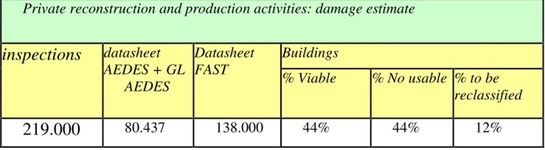
reconstruction and 717 for temporary relocation. The scenario on the estimate of the damage remains, that of the data resulting from the 219,000 inspections carried out by the Civil Protection.
Table 4 – Private reconstruction and production activities: damage estimate. By Civil
Protection
Private reconstruction and production activities: damage estimate
inspections datasheet AEDES + GL AEDES Datasheet FAST Buildings % Viable % No usable % to be reclassified 219.000 80.437 138.000 44% 44% 12%
The situation emerged from the reading of the Mude data is a number of files submitted that is lower than the one that could be estimated with the estimate of the damage. Instead of the expected 96,000 applications (44% of buildings that cannot be used due to direct and / or induced unusability), just over 13,104 have been loaded which represent only 13.7% of the potential situation and which, to an extent equal to 83%, are related to minor.
Tables 5-6 – Private reconstruction and production activities: type of damage and status of
application at 31/12/2018.
Private reconstruction and production activities: type of damage at 31/12/2018
Region Severe housing damage ordinance 13 Severe damage to productive activities ordinance 13 Slight damage ordinances 4 and 8 Abruzzo 961 201 5.972 Lazio 76 11 473 Marche 659 83 3.576 Umbria 94 30 968 Total 1.790 325 10.989
166 Private reconstruction and production activities: status of application at 31.12.2018
Region Presentated Completed
In elaboraton (CUP) Under processing at USR In compilation on Mude Abruzzo 1.164 11 40 1.113 384 Lazio 559 43 145 371 156 Marche 4.317 573 850 2.894 865 Umbria 1.048 136 229 683 239 Total 7.088 763 1.264 5.061 1.644
With regard to private reconstruction and minor damage, classified through the AeDes sheets such as B and C, it would be advisable to allow the Municipalities to be subjects of single commissioning and centralizing bodies. In this way, following a streamlining of the preliminary investigations on the presentation of documentation by the professionals for the pre-investigation phase, and following subsequent release by the USR of the operational level of damage, with a declaration of adequacy of the technical-economic framework (QTE) presented by the professional himself, the Municipality would find itself providing permission for quick building. It derive that following the release by the Civil Engineers of the seismic authorization, the professional could present the metric calculation with the release of the decree in definitely much more suitable times. The subsequent procurement phase, would be carried out by the Municipalities, which, if properly equipped with additional qualified technical personnel, will be able to guarantee a faster reconstruction allowing the citizens to regain possession of their houses.
The assumption of responsibility by the Municipalities, professionals and the ability to release authorizations from the USR staff, would guarantee the effectiveness of the measure. The quality assurance of the reconstruction is insured by the controls pursuant to the experimental agreement for the coordination of the institute activities of the "Italy anti-mafia earthquake prevention mission structure", with the extraordinary commissioner's structure for post-quake reconstruction 2016 and the Judicial Activity on the subject of reconstruction in the Marche. This protocol of agreement, stipulated on 1st March 2019 in Ancona in addition to the possibility of being extended to the entire “crater” area, is certainly a highly useful tool to
167
guarantee the quality of reconstruction as well as the effectiveness of control and safety on construction sites, both them public or private.
S as Schools
The school plays a role of attractor of communities like the productive settlements, and a sustainable school represents the pivot of a territory unquestionably subjected to a process of progressive depopulation that was moreover evident already before the 2016 seismic events. Examination of data, relating to interventions on school buildings regulated by ordinances n.14, n.33, n.56 and n.67, suggests the interpretation of some ideas as they were dictated more by an approach to reconstruction preparatory to public and media consent rather than the result of careful strategic planning for the reconstruction of the communities. This is demonstrated by the adoption of interventions (that have undergone a revision in terms of both quantity and detection or location) on plexuses that do not appear to be characterized by corresponding seismic damage. With the order
n. 63 of 6 September 2018, the approval of the projects and the issue of decrees granting contributions for all public works is the responsibility of the Presidents of the Region. This includes 81 schools (15 in Abruzzo, 13 in Lazio, 34 in the Marche and 19 in Umbria. Total cost of the interventions: 231,038,692.30 euros.
Table 7 - Private reconstruction and production activities: status of application at 31.12.2018
Private reconstruction and production activities: status of application at 31.12.2018
Region Presentated Completed
In elaboration (CUP) Under processing at USR In compilation on Mude Abruzzo 1.164 11 40 1.113 384 Lazio 559 43 145 371 156 Marche 4.317 573 850 2.894 865 Umbria 1.048 136 229 683 239 Total 7.088 763 1.264 5.061 1.644
168
concern schools outside the crater.
Regarding Ordinance n. 14 of 16 January 2017, in charge of the extraordinary commissioner's structure, it’s to be reported that the 21 schools planned, of which 18 financed by the commissioner, 1 in Abruzzo, 2 in Lazio, 11 in the Marche, 4 in Umbria and 3 from private donations, for an amount of over € 95 million, in most cases they can be used from September 2019. The schools are examples of how cooperation between the special commissioner and the actuator subjects is necessary, and how the procedural procedure can be speeded up without necessarily departing from the respect of the control rules (ANAC National Autority against Corruption and the Ministry of the Interior's Mission Structure, standards contributions, urban-artistic-landscape constraints). However, it is to be specified that in the face of an allocation of 103 million euros, to date only 11.5 million have been decreed, a sign that the works are far from being completed, even these schools are considered strategic enough to be the object of a specific issued, even before the last seismic event of 18 January 2017. One of the reasons for this criticality, would seem to be related to the fact to put the final level projects at tender base without any formal opinion: this meant that when the executive project was presented by the company, critical issues related to constraints, with denial of opinions by interested entities, and consequent increase in accumulated delays. Having the project presented to the winning bidder only after the assignment of the order means that, where a minimum problem arises, this not only forces the project to be revised with the consequent increase in costs, but it slows down the reconstruction at the moment in which it appears more concrete, exposing the commissioner structure also to legal actions. The recourse to the form of contract, which envisages the awarding of the executive design and execution of the works, called the integrated contract, already provided for in law n. 109/94 and confirmed in Legislative Decree no. 163/06, to the company awarded the contract, it seems therefore to have created several difficulties due to the need to place the final project, which constitutes the basis of the tender, and to acquire all the opinions only after the preparation of the executive project creating thus further delays.
W as WEB
The commissioner's website provides a public communication service towards all interested parties, to comply with regulatory obligations on administrative transparency, on the Commissioner's records and serves as a
169
hub to all other platforms.
For the creation of the site a Content Management System (CMS) was used, distributed with an open source license (GPLv2) with no cost and therefore very widespread even in the public administration, called Wordpress (version 4.6.1) on which a customization was developed. Graphic layout consistent with the guidelines on the design of public administration websites. The service can be reached from the following URL https://sisma2016.gov.it
References
Aringoli, D., Bufalini, M., Farabollini, P., Giacopetti, M., Materazzi, M., Pambianchi, G. & Scalella, G., 2018, “Effetti geomorfologici e variazioni idrogeologiche indotti dai terremoti: esempi nell’area epicentrale della sequenza sismica 2016-2017 del centro Italia”, Geologia dell’Ambiente, suppl. 1/2018, 239-248.
Aringoli, D., Farabollini,, P., Giacopetti M., Materazzi, M., Paggi, S., Pambianchi, G., Pierantoni, P.P., Pistolesi, E., Pitts, A. & Tondi, E., 2016, “The August 24th 2016 Accumoli earthquake: surface faulting and Deep-Seated Gravitational Slope Deformation (DSGSD) in the Monte Vettore area”, Annals of Geophysics, 59(5), https://doi.org/10.4401/ag-7199.
Calzolari, L., 2018, “Come i media raccontano un’emergenza”, Geologia
dell’Ambiente, Suppl. 1/2018, 80-84.
Cheema, A.R., Mehomood, A. & Imran M., 2016, “Learning from the past: analysis of disaster management structures, policies and institutions in Pakistan”, Disaster Prevention Management, 25, 4, 449-463.
Civico, R., Pucci S., Villani, F., Pizzimenti, L., De Martini, P.M., Nappi, R. & the Open EMERGEO Working Group, 2018, “Surface ruptures
following the 30 October 2016 Mw 6.5 Norcia earthquake, central Italy”
Journal of Maps, 14(2), 151-160,
https://doi.org/10.1080/17445647.2018.1441756.
Coltorti, M. & Farabollini, P., 2002, “Quaternary evolution of the Castelluccio di Norcia Basin (Umbro-Marchean Apennine, Central Italy)”, Il
Quaternario, 8 (1): 149-166.
D.L. 189/2016 (GU Serie Generale n.294 del 17-12-2016) - Interventi
urgenti in favore delle popolazioni colpite dagli eventi sismici del 2016.
D.L.109 / 2018 of 28 September 2018. Decreto Genova.
170
Amatrice seismic sequence: First geological results”, Ann. Geophys., 59(5). Farabollini P., Angelini, S., Fazzini, M., Lugeri, F.R., Scalella, G. & GeomorphoLab, 2018, “La sequenza sismica dell’Italia centrale del 24 agosto e successive: contributi alla conoscenza e la banca dati degli effetti di superficie”, Rend. Online Soc. Geol. It., Vol. 46, https://doi.org/10.3301/ROL.2018.45.
Farabollini, P., Aringoli, D., Materazzi, M., Pambianchi, G. & Scalella, G. 2017, Large Landslides and Deep Seated Gravitational Slope Deformation
triggered by the 2016-2017 central Italy seismic crisis: first evidences from the Mount Vettore-Mt Bove epicentral area. Abs. Int. Workshop “From 1997
to 2016: Three destructive earthquakes along the central Apennine fault system, Italy”. July 19-22, 2017.
Farabollini, P., Lugeri, F.L. & Lugeri, N., 2018, “Humankind and Risk: a difficult history”. In: Antronico L. & Marincioni F. (Eds.), Natural Hazards
and Disaster Risk Reduction Policies, Geographies of the Anthropocene book series, Il Sileno Edizioni, Rende, 88-103.
Farabollini, P., Lugeri, F.R., Aldighieri, B. & Amadio, V., 2014. The role
of Earth Science and Landscape approach in the ethic geology: communication and divulgation for the prevention and rediction of geological hazard. IAEG Torino 2014 Proc., Engineering Geology for Society and Territory, vol. 7, Springer Int. Publ. (DOI: 10.1007/978-3-319-09303-1_22). ISTAT, 2016. Focus: Caratteristiche dei Territori colpiti dal sisma del 24
agosto 2016. www.istat.it.
Lanzini, M., 2018, “Evoluzione delle normative sismiche in Italia dal punto di vista geologico”, Geologia dell’Ambiente, suppl. 1/2018, 107-112.
Lombardi M., 2005. La comunicazione dei rischi naturali. V&P ed., 230pp.
Lugeri,, F., Farabollini P., Amadio, V. & Greco, R., 2018, “Unconventional Approach for Prevention of Environmental and Related Social Risks: A Geoethic Mission”, MDPI Geosciences, vol. 8, ISSN: 2076-3263, doi: 10.3390/geosciences8020054.
Pierantoni, P., Deiana, G. & Galdenzi, S., 2013, “Stratigraphic and structural features of the Sibillini Mountains (Umbria-Marche Apennines, Italy)”, Ital. J. Geosci., 132(3), 497-520.
Tondi, E. & Cello, G., 2003, “Spatiotemporal Evolution of the Central Apennines Fault System (Italy)”, Journal of Geodynamics, 36, 113-128.
Valensise, G., 2018, “La prevedibilità dei disastri sismici fra sismologia e storia”, Geologia dell’Ambiente, suppl. 1/2018, 24-30.
171
Valeriani, E. & Bertelli, A., 2017, L’attività del Commissario
Straordinario ed il futuro della ricostruzione del Centro Italia: una strategia sostenibile. https://sisma2016.gov.it/ Websites www.agi.it/cronaca/terremoto_centro_italia_i_numeri_del_sisma-1213113/news accessed on 10.10.2018 www.beniculturali.it/mibac. accessed on 10.10.2018
www.protezionecivile.gov.it (a) FAQ "Qualificazione e compiti dei liberi
professionisti" raccolte sul sito del Commissario per la ricostruzione.
accessed on 10.10.2018
www.protezionecivile.gov.it (b) FAQ "Sopralluoghi e verifiche di
agibilità" raccolte sul sito del Dipartimento della Protezione Civile. accessed
on 10.10.2018 www.sisma2016.gov.it accessed on 10.10.2018 www.anagrafe.sisma2016.gov.it accessed on 10.10.2018 www.assistenza.sisma2016.gov.it accessed on 10.10.2018 www.intranet.sisma2016.gov.it accessed on 10.10.2018 www.oopp.sisma2016.gov.it accessed on 10.10.2018 www.professionals.sisma2016.gov.it accessed on 10.10.2018 www.scuola.sisma2016.gov.it accessed on 10.10.2018