Housing Policies and
Urban Economics
HoPUE
ISSN 2385-0671 [Online]
Co Editors in Chief: Barbara Ferri, Antonella Violano Editorial Scientific Board:
From Università “G. D’Annunzio”, Chieti-Pescara, Italy: Ottavia Aristone, Vincenzo Corsi, Adriano Ghisetti Giavarina, Francesco Girasante, Fabrizio Maturo,
Giammichele Panarelli, Claudio Varagnoli, Lucio Zazzara
From Università “Federico II”, Napoli, Italy: Maria Cerreta, Pasquale De Toro, Luigi Fusco Girard
From University of Almeria, Spain: Salvador Cruz Rambaud
From Università “L’Orientale”, Napoli, Italy: Amedeo Di Maio, Pietro Rostirolla From University of Defence, Brno, Czech Republic: Sarka Hoskova Mayerova From Academy of Sciences, Warsaw, Poland: Janusz Kacpryzk
From Università di Trento, Italy: Ricardo Albert Marques Pereira
From Universidad Pablo de Olavide de Sevilla, Spain: José Luis Sarasola Sànchez-Serrano
From Universitatea Alexandru IoanCuza, Iasi, Romania: Daniela Soitu
From National Technical University of Athens, Greece: Alexandra Sotiropoulou From Università del Sannio, Benevento, Italy: Massimo Squillante
From Politecnico di Milano, Milano, Italy: Stefano Stabilini, Roberto Zedda From Università IUAV di Venezia, Venezia, Italy: Stefano Stanghellini From Università di Pisa, Pisa, Italy: Gabriele Tomei
From Politecnico di Bari, Bari, Italy: Carmelo Torre
From Seconda Università di Napoli, Aversa, Italy: Aldo Saverio Ventre, Antonella Violano, Antonio Rosato, Monica Cannaviello, Antonio Bosco
From HochschuleZittau/Görlitz, Germany: Matthias Theodor Vogt From GuangdongUniversity of Technology (GDUT), China: Nicholas You
Editorial Manager and Webmaster:
Giuseppe Manuppella, Presidente APAV – Pescara, Italy
Direttore Responsabile:
Bruna Di Domenico, Università “G. D’Annunzio”, Chieti-Pescara, Italy
Graphic design, cover and layout
ISSN: 2385-1031 (print) ISSN: 2385-0671 (online)
Preface
Barbara Ferri
1
THEME “Public space, urban and environmental redevelopment”
The Temporary City: The Transformation of Refugee Camps from fields of Tents to Permanent Cities
Hind Alshoubaki
5
The child, the shaman and the sense of the place
Antonio Bosco
17 Bicycle network is an opportunity to design the public space.
The case study of Montesilvano
Antonio A. Clemente , P. Chiavaroli, G. Girasante (invited paper)
27
City in exhibition
Antonella Violano, Julio Cesar Perez (invited paper)
45 Recycling the existing city: Improved mobility and possible scenarios of public
space
Lucio Zazzara(invited paper)
53
THEME “Building quality and energy resources”
New urban quality of via Sopramuro: metamorphic pattern of a technological design
Mariangela Buanne
65 Daylighting and solar control in school environments
Monica Cannaviello
73 Su[n]stainable System
Façade restoration and energy adaptation
Carlo Coppola
27
Bicycle network is an opportunity to design the public
space. The case study of Montesilvano
Antonio A. Clemente1 Paolo Chiavaroli2 Giulio Girasante3
1Ricercatore in Urbanistica
Università degli Studi “G. d’Annunzio” Chieti Dipartimento di Architettura
2, 3Borsa di ricerca
Università degli Studi “G. d’Annunzio” Chieti Dipartimento di Architettura [email protected] [email protected]
Abstract
The Research Convention between the Department of Architecture of Pescara and the Municipality of Montesilvano has as its purpose the identification of an Agenda of Guidelines for the Qualification of Bicycle Routes. After about a year, the first results suggest to conceptualize some issues differently. First, you have to define the terms correctly. In Europe, reflection on slow mobility is linked to the rationalization/reduction of traffic and is always linked to both sustainability and ecology. The urban fabric of Montesilvano was heavily influenced by the relationship with the large territorial and urban infrastructures. And it is part of a more general story: the one regarding traffic engineering which, since the postwar period, conceived the idea that we should invest only in large network infrastructures for solving mobility problems. It is not enough. You need to come back to think about smaller networks and, in particular, on bicycle routes. Working on the hypothesis that cycling mobility networks are the potential matrices of a new land project that regenerates urban space, triggering processes of retraining of crossed contexts, forces us to think differently. To be more careful about the specifics. To assume the notion of public space as central.
Keywords: Public space, bicycle network, slow mobility, intermodality, storm water, sustainable urban development.
28
1. Introduction
Slow Mobility, Soft mobility, Sustainable mobility, Zero-traffic mobility, Mobilitédouce, Mobilité durable, Eco-movilidad. Although each of these denominations tends to emphasize particular aspects, there is a substantial convergence in making specific reference to the mobility of human force. The Research Convention1between
the Department of Architecture of Pescara and the Municipality of Montesilvano has as its theme the relationship between Slow mobility and cycle/pedestrian networks. This field of investigation presupposes a definition of terms in order to better focus on the analytic field. In Europe, the reflection on Slow mobility is linked to the rationalization/reduction of traffic and is always closely connected to both the concept of sustainability (environmental, social and economic) and the ecological dimension. In Italy, Slow Mobility themes and objectives clearly emerge from the extraordinary production of Guidelines2. And they show that the areas of study are substantially five:
network identification, signposting, safety, materials and dimensional characteristics of the route. The aims of the guidelines are to spread the use of the bicycle as a means of transport for home-work/school trips; in clarifying the environmental, social and economic benefits related to the use of the bicycle compared to the traditional forms of motorized mobility; ensuring a high standard of safety while minimizing the risk of accidents or any other form of danger for the cyclist; in defining which is the most effective signposting; in identifying the geometric standards of the various types of route.
The field of interest of sector regulations in urban areas is similar. Already in 1995, with the Directives for the drafting, adoption and implementation of the Traffic Urban Plans, the main concern, regarding pedestrians and cyclists, was to “foresee all the useful and necessary interventions to guarantee their safety”3. Subsequently, in 1998 the Norme per
il finanziamento della mobilità ciclistica4 hope, on the one hand, the intermodality
between bicycles and means of public transport and, on the other hand, identify the priority areas for the construction of cycle paths, in the area of sediment of disused railways and river banks. The following year, the Minister of Public Works in agreement with the Minister of Transport issue a regulation laying down rules for defining the technical characteristics of cycle paths5. In 2013 the strategic objectives for urban
cyclomobility of the Regione Abruzzo6 are: the increase of the existing cycle network
(privileging the networking), its safety, also through specific signaling and the connection with the system of collective mobility. Nor can the rules for drafting the Biciplan be ascribed to a very different register.
29
2.First indications to design the public space
In light of these brief considerations it is possible to state that Guidelines and Sector Regulations are placed within a hypothesis quantitative, whose almost exclusive priority is to realize as many kilometers of cycle paths as possible in which security, functionality of the track and intermodality are guaranteed. Numerous studies and research show that this is not sufficient, not only because there is no directly proportional relationship between the kilometers of cycle paths and the number of cyclists who actually use them, but also (and above all) because a series of project actions, planning acts and transport policies that must support and, in some cases precede, the realization of the tracked, are indispensable. Of course, the importance of the Guidelines and the Regulations is not in question, because it is clear that they contain essential indications that, however, remain linked to an abstract cycle network, deprived of references to the specifics of the places, to the peculiarities of the territories and of the landscapes that crosses. This work perspective brings out a plurality of issues that require a different conceptualization. Three main ones.
First of all, the cycle network is not just a topic linked to mobility. But also accessibility: “mobility represents the capacity of an individual, or an object, to make movements in space while accessibility identifies the characteristic of who or what is accessible”7. The problem, therefore, does not consist solely in permitting quick and
safe moves from one point of origin to one of destination but also to have the possibility to enjoy the spaces in condition of safety and autonomy; to move in every direction, according to your own choices; to reach any destination, by the vehicle considered most suitable. It is a conceptual itinerary that involves the interdependence between the individual characteristics of the cycle path (and of the network) and the relationship with the contexts crossed. On the other hand, “to access a place or a service of the territory is not enough to move because, similarly to other abilities of relationships, accessibility calls into question all the elements involved in the relationship: the characteristics of the moving subject, the way it does and the ownership of the good or service of the territory that is reached”8. And this is precisely the passage that must be
done in Montesilvano. A virtuous municipality that, after having realized the entire stretch of the Adriatic Cycle and a significant number of kilometers of other cycle paths, it is now called to take the next step: build the network. The passage from tracks to the cycle network is of extraordinary importance: only in this way the city can become a permeable body within which accessibility to schools, to the main facilities and places of urban excellence can be guaranteed. And more generally to all territory. Certainly it is a long-term scenario, considering that the urban fabric of Montesilvano has been strongly influenced by the relationship with the large territorial infrastructures (Railway, State Road 16, Highway A 14) and urban (Asse Attrezzato). And it’s part of a more general story: that of traffic engineering that, from the second post-war has conveyed the idea that to solve the problems of mobility and accessibility one had to only invest in large networks infrastructure. Italian cities have shown that it is not enough. It is
30
necessary to return to reflect on minor networks and, in particular, on the cycling ones. So far it has not been this way.
A second question is about a commonplace that concerns the whole Adriatic city. Montesilvano is compressed between the coast line, the large infrastructure and the Saline river and, at a superficial glance, it appears only like a compact figure. It is not so. Working on the hypothesis that the cyclenetwork is a relational work attentive to the characteristics of the contexts crossed, forces us to think differently; to be more attentive to urban identities; to assume the notion of public space as central. And it is precisely in this way that the potentialities of some areas seem clear. Areas such as the market street of Corso Umberto I that reaches the beginning of via Vestina, the pedestrian cross that is created by the San park John Paul II to the sea, the area between the Town Hall and the Station railway, the area of the big hotels with the Palacongressi and the Multisala, the area of Stella Maris and Villa Delfico. It is the wait of a project that, also through the cycle network, is able to focus on the possibility of conferring urban quality to open space.
Another relevant topic, which is often on the sidelines of the debate, regards the construction methods of the cycle paths. Sometimes, it seems that by just making as many kilometers as possible it is sure that a sustainable result has been achieved. Quantitative perspective is only the first step. Which, however, is not enough. We must also focus on the sustainability of materials and the functions that a track can play, in addition to the one supporting cycling mobility. We show below an example of great importance for Montesilvano, mostly in relation to the frequent allegations of the last years.
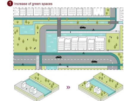
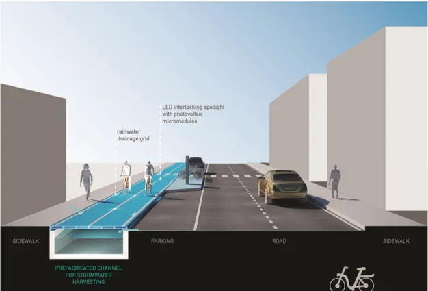
Figure 1. COPENHAGEN: The Copenhagenize Current - Stormwater Management and Cycle Tracks is the strategy used for the rainwater collection. This strategy is composed of three principal actions. Here the first one: Increase of green spaces
31
Near green spaces only permeable materials should be used in order to obtain two positive results: allow a rapid outflow of water and not contributing to the waterproofing of the soil. Good practices are not lacking. Approved in2012, the Climate Adaptation Plan aims to make Copenhagen the first carbon neutral capital by 2025. Within the plan are provided a variety of actions, including integrated measures on mobility and on the collection of first rainwater on public and private land. One of the strategies is called The Copenhagenize Current – Stormwater Management and Cycle
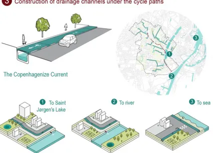
Tracks which consists in creating, below a part of the cycle network, water drain tanks
of meteoric waters in order to collect them from the most exposed areas to floods and convey them to the river. These are concrete channels prefabricated with a cover composed of lightweight modular panels in order to allow both a fast installation and a quick maintenance. Along with these measures, there are also grids of drainage both from the side of the sidewalk and from that of the road to allow the drainage of the water, blocking, at the same time, the passage of debris. Another action considered by the plan defines a new way to integrate urban water in relation to hydraulic aspects, biological and social. The idea is to create green areas for water storage holding rain water in order to channel it outwards of the city or to use it, thanks to underground reservoirs for irrigation.
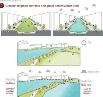
Figure 2. COPENHAGEN: The Copenhagenize Current - Stormwater Management and Cycle Tracks. Here the second strategy: creation of green corridors and green accumulation area
32
Figure 3. COPENHAGEN: The Copenhagenize Current - Stormwater Management and Cycle Tracks. Here the third strategy: Construction of drainage channels under the cycle paths
3.Cycle mobility for sustainable urban development
Lewis Munford in 1938 warned of the consequences of the uncontrolled development of the city: “in the new economy biotech hygiene occupies a dominant position, it implies not only public defense against disease; it also means positive steps to make whole the environment conducive to health, animal joy, long life”.
The eighty years' observation is that the environment is no longer able to guarantee acceptable “minimum hygienic conditions”, so much so that the vital cycles in the ecosystem are compromised and any equilibrium in the territory is precarious: territory is not only identified in the natural earth-water-air-fauna-flora system, but necessarily involves built habitat, especially when the transformations produced by human activity in the environment are not previously evaluated and appropriately controlled.
All this, with the relative differentiations, is placed at the territorial scale for the interventions that can have an important environmental impact both on the urban scale both for any intervention that in any case produces alterations in its environmental system.
“The redevelopment concept implies an integrated approach to the problems of the territory and presupposes a demand for quality (environmental quality, quality of human relations, quality of urban life) that can only be satisfied by targeted interventions and prudent policies, especially in the more high index of urban pollution. In this sense, redevelopment has become above all a completely new way of understanding urban transformations and their government, a process of coordinated planning, of concerted action between the different public and private interests, of mediation between the
33
major objectives of interest general and particular interests, of conception of the overall urban planning of urban mobility, from the renewal of the relationship between population and territory” (Musso and Marcucci, 2011)9. With these initial
considerations, talking about urban development today means imposing policies for the economic, social and cultural development of a city with a view to protecting the environment: it means, therefore, to talk about sustainable urban development. Sustainable development places mobility at the center of the problem. From here, talking about mobility with a view to urban development, means talking about sustainable mobility. Nowadays there are many strategies to deal with the mobility within a sustainable city: incentives for public transport, vehicle sharing, the spread of electric motors, city cars, expansion of intermodal solutions and social activities that promote the movement on foot but, among all, the strategy that is surely redesigning the urban infrastructural network is that of slow mobility, especially cycling.
Cycling in Italy today is finally reconsidering its transport function, abandoning its tourist meaning that it had taken in recent years: for this reason, as it enters the city, the cycle path must lose its landscape vocation and become an urban mobility infrastructure which holds together a series of issues typical of the territory in addition to the ordinary and more specifically technical themes of cycling infrastructures.
4. Consideration in the margins of a research on the territory of
Montesilvano (Pescara).
Working on a consolidated urban fabric like that of Montesilvano means knowing in depth the territory that generated it and its historical change in the last decades to imagine the future scenario in which the cycle network will have its maximum use. From the urban reading of the city of Montesilvano you can see how this presents the characteristics of the “Adriatic City”: a compact fabric included and compressed by the Riviera, the State Road and Railway that cross the river system and the hilly one.
For years Montesilvano has been a city of passage, a fast North-South crossing without its own urban identity, almost a dormitory city of Pescara. This can be read from the driveway and cycle infrastructure network: two parallel connection lines.
But at a careful reading and descending scale we realize how in reality the urban fabric presents the potentialities and transversality worthy of interest as well as urban voids and residual spaces retrained or to be redeveloped. This is the case of widespread commerceon Corso Umberto I and on the beginning of Vestina; the pedestrian cross that is generated from the park San Giovanni Paolo II and reaches the sea through Palazzo Baldoni, the Town Hall and the railway station; of the large hotels that with the Palacongressi and the “Porto Allegro” shopping center, create a great attraction; or it is the case of all those specific polarities that spread throughout the territory: the area of the Palaroma which, in addition to the building itself functioning perfectly, presents an
34
excellent parking area due to its position; Stella Maris and Villa Delfico, both standing on Via Marinelli, create a single unfortunately abandoned system; the stadium and the sports facilities in general.
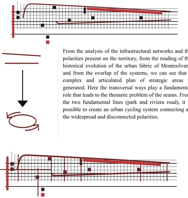
From the analysis of the infrastructural networks and the polarities present on the territory, from the reading of the historical evolution of the urban fabric of Montesilvano and from the overlap of the systems, we can see that a complex and articulated plan of strategic areas is generated. Here the transversal ways play a fundamental role that leads to the thematic problem of the seams. From the two fundamental lines (park and riviera road), it is possible to create an urban cycling system connecting all the widespread and disconnected polarities.
Figure 4. From the actual state to the creation of the system
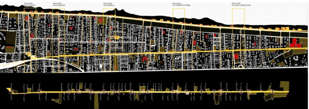
The closing of the cycle network thus becomes the opportunity for a widespread redevelopment of the territory; it affects not only paths but urban spaces creating a slow, attentive and participated process of regeneration for the quality and safety of the city. In the specific case of the city of Montesilvano, five strategic areas have been identified (pilot projects); each area has a main vocation and together constitute the great network of cycling for the sustainable urban development of the city itself.
35
Figure5. The strategic areas
1 SCOPE Grandi Alberghi – Palacongressi
FEATURES accommodation and tourist facilities VOCATION exchange parking
2 SCOPE Via Roma - Via Strasburgo
FEATURES presence of equipment and services
VOCATION crossing, re-stitching, redevelopment and exchange parking 3 SCOPE Via Marinelli
FEATURES presence of a series of abandoned polarities VOCATION re-stitching and redevelopment
4 SCOPE Via Torrente Piomba
FEATURES central position with respect to the longitudinal axis of the park road and discreet traffic load.
VOCATION crossing, connection and experimentation. 5 SCOPE Palaroma
FEATURES
presence of a large vehicular infrastructure (Circonvallazione) and the presence of parking spaces currently at the exclusive service of the sports hall.
VOCATION exchange parking
36
5. (Un)expected opportunities offered by slow mobility networks.
The pilot project of Torrente Piombastreet in Montesilvano
Slow-mobility is receiving greater and greater attention as a low impact sustainable transport system. Less attention, however, is reserved for the potential of slow-mobility for urban renewal and as an opportunity to update the technological networks in a sustainable key. Is the cycle lane network able to trigger redevelopment and renewal processes in the crossed spaces? The research agreement between the Department of Architecture of Pescara University and the Municipality of Montesilvano aims at answering this question.
The challenge is to restore public spaces to people, putting the plurality of open spaces available in the city into a system. The goal is to allow all those who live in the areas concerned to use these spaces, triggering both physical and cultural redevelopment. “Identity is generated by that quality of a certain space which, through the natural or anthropogenic configuration it has, makes the individual aware of the place where he lives, giving him a sense of belonging…” (Kevin Lynch, 1964)10. Another objective is
the possibility of improving technological networks in a sustainable way. This objective is pursued through the use of rainwater harvest and storage systems and by the use of sustainable and innovative materials.
The aim of this research, through slow mobility, is to re-open dialogue between the city and its inhabitants, paying particular attention to the demands dictated by the contexts and its users. The aim is to make cities truly sustainable.
Montesilvano is characterised by the urban structure typical of “Adriatic cities and towns”. A compact fabric compressed between the coast line and the hills, crossing several transversal river systems. Montesilvano has too often been conceived as a town connecting the north and the south without a real urban identity.However, in such a compact context, which does not seem to offer particular quality occasions, a closer look can identify a plurality of places, open spaces, noteworthy urban areas which, indeed, are typical of a town that offers many opportunities.
The current cycle network in the municipality of Montesilvano mainly includes two paths parallel to the coast, which, however, seem to have different specificities. The first path is that of the seafront cycle path that is part of the “bike to coast” project, a project that involves the construction of a cycle path running along the Adriatic coast from Lecce to Venice. The second is the bike path on the “park road” currently connecting Montesilvano and Pescara, which is planned to be extended northwards to the nearby Città of Sant'Angelo.
Since both routes are important but separate, they must be reconnected transversely to create an efficient cycle network at the municipal level, connected to the national network (bike to coast).
37
and, in this regard, analyses were conducted in order to understand what could be the best solution for each connection. The criteria that led to the definition of the most suitable paths for closing the network were mainly selected based on the possibility to involve the main interchange points of mobility, such as the railway station but also a series of car parks located in strategic areas of the town.
In addition to transport and intermodal considerations, the closure of the network also puts the attention on that plurality of public spaces, equipment and open areas that break up the compactness of the Adriatic town by putting them in the network. These spaces include: public car parks, equipped parks, neighbourhood sports facilities, schools, places of worship, hotels, commercial spaces, and some large strategic areas, not properly exploited or totally unused: Villa Delfico, the former Stella Maris, Pala Roma sports centre, Naiadi sports centre, Porto Allegro shopping centre. The study conducted, therefore, shows some opposite poles, but also a sort ofporosity of the urban fabric made of minor equipment and spaces that citizens could use daily as places of social life, opportunities for urban regeneration.
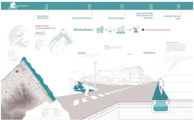
Figure 6.System of public spaces and connectionsbetween “park road” and “bike to coast”
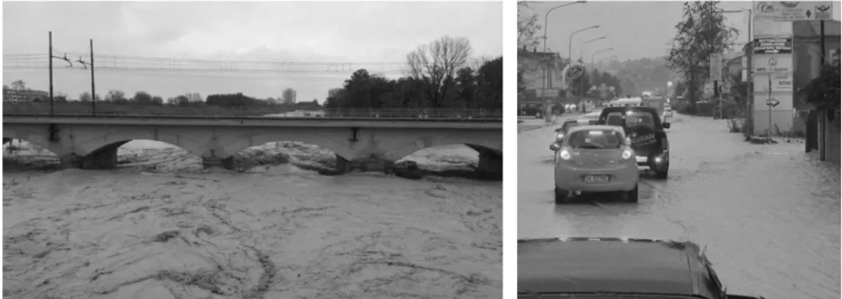
Another very important criterion of which is kept in mind in choosing the transverse layouts of reconnection binds to the concept of sustainability through the water collection system. The municipality of Montesilvano more and more often presents flooding phenomena due to heavy rainfall. Heavy rainfall occurring more and more frequently creates problems to entire portions of towns near the coast, and the northern part of the town is under constant threat from the floods of the Saline river. The most significant events in recent years are as follows:
1992 flooding of the Saline river affecting the Montesilvano Marina area; 2012 collapse of the embankment of the Saline river;
2015 flooding of the Saline river with damages to the industrial area; 2016 traffic closure of the seafront area due to heavy rains;
38
Figure 7. Images of the floods occurred on the municipal territory. Images taken from: Panorama.it, cityrumors.it
The chronology of the events confirms that floods are more and more frequent, that is why the solution to this problem is urgent. The cycle layouts have been assembled mainly in the sensitive areas and in the areas that have ample green portions. This is because the cycle net is bearer of new technological nets able to collect and to store the rainwater. So the collected waters can be reused to irrigate the green areas in the summer season. While in the cases in which the rains provoke flood events, the system for collecting will becomes another element of outflow of the waters.
To understand which are the potentialities of this approach various pilot projects on different transversal aces of reconnection have been developed.
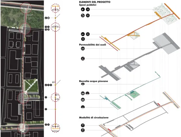
Pilot projects provide the methodological directions to the cycle path. The pilot projects in question were born with the aim of identifying and selecting contexts that were particularly significant with regard to different aspects and that provide satisfactory answers to the problems in place. The solutions found with a pilot project can be transferable and repeatable even in other similar contexts. In particular, the case of Torrente Piomba street is emblematic because it allows us to tackle all issues put in place by research.
The case of Torrente Piomba street forces us to reflect on three main themes: the reconnection and use of open spaces, environmental sustainability and safety. We have already specified how the slow mobility networks provide the opportunity to live the contexts crossed. Nowadays, along Torrente Piomba street there are many public spaces not properly considered.
Here there are the Dean Martin park, the coastal pinewood, a small refreshment area near the pinewood and a series of free spaces unused or used as a parking space. The aim of the research is to regenerate these spaces by reconstruction and resurfacing. For this reason, complementary equipment was provided for the slow mobility system and for a physical and functional rethinking of some areas. In particular a rest area has been proposed next to the park road at the top of the transverse axis and as a focal point for the identification of the route. For the Dean Martin park it was proposed to upgrade the already existing function, increasing its usability.
39
The park is easily reachable through the bike path and the pedestrian path, there are parking areas for bikes near the park and a new access to it. For the refreshment area, it is planned to upgrade it by rethinking the parking areas. It is planned to increase service facilities and to expand them outside in suitably planned areas. The expansion of the facilities for services will be realized by the interventions planned in the area of the coastal pinewood that, if implemented, will increase the load of possible users.
For the area of coastal pinewood different possible scenarios have been planned, by adding a series of features compatible with its natural heritage.
One solution include a series of sports equipment, such as cyclocross paths connected to cycle paths, with a series of equipment for outdoor training, racing circuits, minor sports facilities.
A second solution aims at integrating bike paths with parking areas for bikes and seats to recreate leisure and socialization areas, with a series of restaurants facilities or equipment for the maintenance of bicycles, bike rental facilities or other sports facilities that, especially during the summer season, attract many tourists. A final solution is to equip the pinewood with parking areas for bikes and seats serving play areas for children.
The slow mobility is the object of growing attention about the environmental sustainability, because it is a low-impact transport system.
It is immediately possible find a sustainable nature inherent in the very concept of slow mobility or sustainable mobility because the movement is operated by the human muscular strength.
Another diffused aspect of the sustainability linked to the slow mobility, is the possibility to give up gradually the car transport to replace it with the cycle mobility, with the use of other forms of sustainable mobility as train, bus, trolley bus, etc.
However there are further declinations of the concept of sustainability feasible through the establishment of a cycling network.
One of the most successful experiments, since this research takes borrowing north European models, is the possibility of integrating the rainwater collection system to cycle paths. This system results particularly suitable to the case of Montesilvano, given the deep problem due to the frequent floods already mentioned.
The rainwater collection system, integrated in the cycle paths, can solve many problems. In the case of Torrente Piomba street the insertion of the cycle path on existing roadway has been anticipated. In this case it would be enough to insert a curb of separation to distinguish the two layouts. This element of separation has been dilated to accommodate a rain garden. The system allows to collect and to purify the waters of before rain from roads, while those arising from the bike path don’t have oil and polluting particles, as we find on the streets instead. The water collected and purified are conveyed by a tube draining and accumulated to be reused to irrigate green areas.
The tubs are located near Dean Martin Park and at the warhead on the “park road”. During periods of heavy rainfall, the collection system become an additional element of
40
runoff, and the collection takes place through expansion boxes. In this way a sustainable water management process is triggered, that allows to reduce the maintenance cost of the green areas and to resolve problems of flooding. It seems clear that a system of this type can produce huge benefits against a small cost.
The research tries to answer to another issue linked to the phenomenon of flooding, that is the permeability of the soil. In urban areas the hydrogeological troubles are directly related to the lack of permeable soil, that are able to dispose the water load to which they are submitted. For this reason it is fundamental not to subsequently water proof the soil. For this layer in totally permeable cement has been studied, an highly innovative material that allows to leave the permeability of the soil unchanged and it furnishes a comfortable and sure surface at the same time for cyclists. To create road signs it is also expected the use of non-toxic water-based paint. These materials have been used in the line in which the cycle path crosses the pinewood, to leave the permeability of the grounds unchanged. Obviously could be used for the whole cycle layout that crosses the Torrente Piomba street increasing the actual general permeability of this street line. The system of management of the water, the attention to the care of green areas and the use of sustainable materials, are the themes that bring the concept of sustainability to a further level of specialization.
41
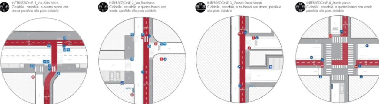
Ultimately, the via Torrente Piomba pilot project offers the opportunity to reflect on the safety element.
All the points of potential danger have been analyzed, that is the intersections between the different mobility systems: a spatial resolution has been proposed, also providing indications on the vertical and horizontal road signs and on the protection devices.
Figure 9. Resolution of intersections among the different mobility systems
The case of Torrente Piomba street provides us an useful tool to understand what might be the actual developments and potentialities linked to the cycle mobility. The most and innovative aspect is the will of contextualize the interventions, from time to time adapting the system of mobility to the different needs dictated by the crossed contexts. Contextualizing means to gather the potentialities of the urban fabric and to exploit the slow mobility for the creation of a net of public spaces. The slow fruition of the territory attributes to the slow mobility the power to retrain the crossed space, for that you have to pay particular attention to the context, to the places that the path crosses, to the possible public spaces or the equipments to reconnect, to the possible relationship that are created. Contextualizing also means to accept the requests of the city and to provide concrete solutions. As well as the necessity to resolve the problems of flood that, trough the integrated system of harvest of the waters, find a particularly careful solution to the concept of sustainability.
The attention to the context and the demands of the city invites to reflect on what the real opportunities offered by slow mobility networks are.
6. Conclusions
To understand the potential of Slow Mobility it is necessary to change the point of view. More specifically, it is important to underline how the cycle network is not a small highway that, by its nature, “proposes an effect of extraterritoriality” in which “the monofunctionality (linking a place to the other), the specialization (space reserved for the movement of vehicles) and speed exclude functional relations with the surrounding territory)”11. Slow mobility feeds on the contexts it traverses: it is not a policy of sector.
42
remaining alongside something, does not care to activate any link with it; or a gallery that, passing below, does not create any relationship with the territory; or, again, a viaduct that, crossing the landscape at altitude, does not open up any possibility of dialogue. In other words, technical functionality, safety of the route and intermodality between different systems of transport (cycle-pedestrian, public and private driveway, railway), must have the same importance of the relationship that the cycle network can establish with the contexts crossed.
And this is precisely the reason why it is necessary that the cycle network becomes the presupposition of a soil project that knows how to take responsibility for glimpsing some possible answers to great topics such as, for example, better management of the first rain waters. Addressing a topic of such importance does not mean to simply evoke it but to imagine architectural devices that are able to become, in the first instance, project hypothesis and, subsequently, realizations. This is the responsibility that the research must take. Hence the decision to provide evaluation tools and planning guidelines for the municipal administration, both to guarantee adequate performance levels of cycling networks and to guide the morphological quality of interventions, taking into account the multiple relational and topological values expressed by the territory.
43
Figure 11. Concept with the technological innovations and dimensional morphological features of the new cycling network
Acknowledgement
In this paper the paragraphs 1-2-6 are by Antonio Alberto Clemente; paragraphs 3-4 are by Giulio Girasante; paragraph 5 is by Paolo Chiavaroli.
Endnotes
1 The inter-institutional collaboration between the Department of Architecture of Pescara and the
Municipality of Montesilvano, in line with the Protocol of Understanding, provides a two-year duration (2017/2018). Research group: Scientific responsible - Prof. Paolo Fusero; Scientific coordination - Prof. Antonio Alberto Clemente; Fellows - Arch.tti GiulioGirasante, Paolo Chiavaroli. Collaborators: Arch. ParideTaurino, Eng. Francesco Rossi, Eng. Cristina Affatato, Eng. Angelica Nanni, Giuseppe Leone, PierluigiPetaccia, Giuseppe D'Abbraccio.
2 It is impossible to give an exhaustive account of the Guidelines in this area. It is however considered
useful to mention some of the most relevant: AA.VV.,The city by bicycle. Designing cycle paths to
improve the environment, ARPAV and FIAB, 2007 http://www.arpa.veneto.it/; Carlo Socco, Chiara
Montaldo (edited by), Guidelines ZONE 30. The network of cycle paths, publication of the Sustainable Cities Observatory of the Politecnico di Torino, 2007 http://www.regione.piemonte.it/; AA.VV.,Guidelines PRESTO Promote the bicycle as a means of daily transport for everyone, publication of the European Community, 2010 http://www.rupprecht-consult.eu/; AA.VV., Guidelines.
Developing and Implementing a Sustainable Urban Mobility Plan, Co-funded by the Intelligent Energy
Europe. Program of the European Union, 2014 www.eltis.org/
3 The Directives are issued by Min. LL.PP. (G.U. No. 146 - 24 June 1995), according to the Art.36 of the
legislative decree of April 30th 1992, n. 285. New highway code.
4 Law n.366 of October 19th 1998.
5 Ministerial Decree n.557 of November 30th 1999. 6 Abruzzo Region Law n.8 of March 25th 2013.
7 Marco Castrignanò, Matteo Colleoni, Cristina Pronello (edited by), Muoversi in città. Accessibilità e
44
8ibidem
9 Edoardo Marcucci, Enrico Musso, (a cura di), Sostenibilità, qualità e sicurezza nei sistemi di trasporto e
logistica, Franco Angeli, Milano 2011
10 Kevin Lynch, L’immagine della città, Marsilio, Venezia 1964
COPYRIGHT © 2014 All rights reserved
Editore: Accademia Piceno - Aprutina dei Velati in Teramo (APAV) Via del Concilio n. 24, Pescara, Italy
Codice Fiscale: 92036140678 Partita IVA: 02184450688 Codice destinatario per fatturazione elettronica: M5UXCR1
IBAN: IT 73 E 02008 15413 000104232062 – BIC Swift: UNICRITM1RM4 Banca Unicredit (succ. Pescara Umberto)
Periodicità: semestrale
Siti web: www.apav.it ; www.eiris.it
Email: [email protected], [email protected]
Autorizzazione n. 16 del 17/12/2013 del Tribunale di Pescara ISSN: 2385-1031 (testo stampato)
ISSN: 2385-0671 (online)
Stampato a Pescara il 14 agosto 2019