UNIVERSITÀ DEGLI STUDI DI CATANIA
Facoltà di Scienze Matematiche, Fisiche e Naturali
Dipartimento di Scienze Geologiche
DOTTORATO DI RICERCA in
“Evoluzione geologica di orogeni di tipo mediterraneo”
XXIII CICLO
“
Paleoseismological off- fault analyses in eastern Sicily: a contribute to
Tesi di dottorato in “Evoluzione geologica di orogeni di tipo
PALEOSEISMOLOGICAL OFF- FAULT ANALYSES IN EASTERN SICILY: A CONTRIBUTE TO THE CHARACTERIZATION OF SEISMIC SOURCES
Riassunto……….……...i
Abstact ………...i
Chapter 1 1- Geological and seismological features of Sicily………..…...1
1.1- Geological and structural setting of eastern Sicily………...………...2
1.2- Eastern Sicily historical earthquakes and related seismogenic sources ……..…………7
Chapter 2 2- Earthquake Geology………...………..18
2.1- Primary effects………...20
2. 2- Secondary effects ………...……..22
2.2.1- Landslides and rock-falls ………...…....23
2.2.2- Ground deformations ………..……...26
2.2.3- Liquefactions: soft sediment deformations ……….…...30
2.2.4- Hydrological anomalies ………...……..34
2.2.5- Tsunami deposits ………..…… 35
Chapter 3 3- Paleoseismology ………..39
3.1- Paleoseismological investigations.……….……..……….40
3.1.1- Historical data analysis ………..….…...41
3.1.2- On-fault Paleoseismology ……….………...…...43
3.1.3- Off-fault Paleoseismology ………...…...45
3.1.3.1- Near fault geomorphological investigation ……….………..…...46
3.1.3.2- Stratigraphic record analysis ……….….. ……….………..….…...47
Chapter 4
4- Historical databases of seismogeological effects in Sicily and empirical relationships
between source parameters vs epicentral distances..………....….53
4.1-Historical records of seismogeological effects in Sicily: analysis and classification….53 4.1.1- A-class: landslides. ………....55
4.1.2- B-class: ground deformations………...56
4.1.3- C-class: liquefactions………...57
4.1.4- D-class: hydrological anomalies ………....…58
4.2- Databases of the seismogeological effects………..…...…59
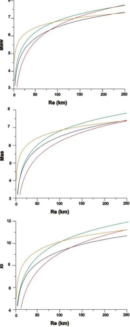
4.3- Empirical relationships between magnitude/ intensity versus epicentral distance (Re)………61
4.4- Data analysis………..…61
Chapter 5 5.Study of the deformative structures ………..…72
5.1-Method………...…72
5.2- Minissale site………...…..74
5.2.1-Minissale trench study………...…….76
5.3- Agnone site. ………..………...…….80
5.3.1-Agnone trench study………..……….……82
5.4- Vendicari site………..………..……….……88
5.4.1- Analysis of the deformation structures ……….………..….………..91
5.4.1.1-Brittle deformation analysis………..………...…93
5.4.1.1.1-Microscopic thin section analysis………..…..………..…...97
5.4.1.2-Soft sediment deformation structure analysis……….…..……..98
Tesi di dottorato in “Evoluzione geologica di orogeni di tipo
5.5.3.2-Soft deformations……….…..………..………...……..…….107
5.5.3.3-Chronology of the deformative events………...………...…….109
Chapter 6 6- Study of tsunami deposits ……….………….110
6.1- Analysis of sandy deposits ………..111
6.1.1- Method ………...………111
6.1.2- Study sites ………...……….112
6.1.2.1- The Augusta Bay………..….112
6.1.2.1.1- On shore study ………...……113
6.1.2.1.2- Off shore study………..….….116
6.1.2.2- Pantano Morghella………..….…..121
6.2- Study of boulders ……….…...123
6.2.1- Method ……….…....123
6.2.2- Study sites……….127
6.2.2.1- Capo Campolato site……….…….127
6.2.2.2- Vendicari site………...131
6.2.2.3- S. Lorenzo site……….……….………….133
6.3- Data Analysis……….……….….134
6.3.1- Study of sandy deposits………..………….….135
6.3.2- Boulder study….………...……..…...…….135
Chapter 7 7- Discussions and conclusions………..137
Appendix A………....141
Appendix B …………..………….………170
Appendix C………...……….179
References…………...………...182
Riassunto
La ricerca effettuata consiste in uno studio paleosismologico off-fault, ovvero nell’ analisi e datazione di effetti sismogeologici innescati in Sicilia dai terremoti storici e paleo terremoti della Sicilia e della Calabria meridionale. La scelta del tipo di effetto studiato è dettata dalle problematiche sismogeologiche di questa regione. Infatti in Sicilia sono avvenuti eventi tra i più disastrosi della storia sismica Italiana, ma la reale definizione e collocazione delle sorgenti sismogenetiche è un argomento tutt’oggi aperto e fortemente dibattuto, poiché questi eventi sono avvenuti in epoca pre- strumentale e non hanno lasciato evidenze geologiche di fagliazione superficiale. Al contrario, questi terremoti hanno innescato numerosi effetti sismogeologici nell’area epicentrale, ben descritti dalle fonti storiche. Pertanto, considerando anche il suo ricco e antico patrimonio storico, la Sicilia rappresenta un ottimo laboratorio dove testare diverse metodologie di studio paleosismologico off fault.
Gli scopi della ricerca svolta sono molteplici ed in particolare consistono da un lato nella possibilità di fornire nuovi e utili dati per meglio comprendere la sismicità della Sicilia, dall’altro lato di testare studi innovativi in una regione dove questo tipo di indagine è stata scarsamente applicata.
La ricerca effettuata segue due principali linee. In una prima fase è stata analizzata la sismicità regionale della Sicilia ed è stata effettuata la raccolta e l’analisi delle fonti storiche originali e del patrimonio documentario esistente, successivamente è stato realizzato uno studio di campagna al fine di trovare ed analizzare direttamente in sito le strutture sismogeologiche.
I dati storici raccolti, che consistono in descrizioni di effetti sismogeologici, quali frane, liquefazioni, deformazioni del terreno e anomalie idrogeologiche, sono stati criticamente analizzati e classificati. A questo scopo è stata effettuata la caratterizzazione litologica e
Tesi di dottorato in “Evoluzione geologica di orogeni di tipo ii suscettibilità del territorio al loro verificarsi, mediante l’utilizzo di software GIS. Inoltre, i dati sono stati utilizzati per l’estrapolazione di relazioni empiriche tra i parametri di sorgente (Maw, Mas e Io) e le distanze epicentrali del sito (Re) per ogni effetto sismogeologico, mediante il metodo dell’ upper bound-curve che indica la soglia massima di innesco dell’effetto.
Questa prima fase di ricerca ha messo in luce che la Sicilia è una regione altamente suscettibile allo sviluppo degli effetti sismogeologici. In particolare frane e deformazioni del terreno rappresentano gli effetti più frequenti, che si verificano per i più bassi valori di energia e sono maggiormente concentrati nel fianco orientale del Monte Etna, che risulta caratterizzato sia da fatturazione cosismica che asismica, e nel settore settentrionale della cintura Orogenica (Catena Appenninico Maghrebide e Catena Kabilo Calabride), caratterizzato da complesse formazioni strutturali in stato di persistente instabilità. Liquefazioni e anomalie idrologiche sono risultate meno frequenti, si generano per più alte soglie di energia, ed i settori maggiormente suscettibili sono la valle del Belice e la Piana di Catania, caratterizzate da depositi olocenici, non consolidati e generalmente saturi d’acqua. Inoltre, l’utilizzo delle upper- bound curves ha messo in luce possibili errori nella definizione dei parametri focali di alcuni terremoti ottenuti dal campo macrosismico. Per esempio il terremoto del 5 Marzo 1823 della Sicilia settentrionale, che è stato localizzato nei cataloghi vicino Cefalù, potrebbe essere localizzato a mare e avere una magnitudo maggiore di quella stimata. Infine possibili effetti di amplificazioni di sito e di eccezionale risposta di sito sono stati messi in luce nei grafici delle upper bound curves, da punti ricadenti a distanza superiore da quella prevista, come dimostrato dagli effetti osservati a Messina durante il terremoto del 1783 (M= 4.20) e a Calatafimi (Trapani) durante l’evento del 1693.
I risultati ottenuti durante la prima fase di studio sono stati anche utilizzati come punto di partenza per indirizzare l’analisi in sito delle strutture deformative sismoindotte. Infatti questa ricerca è stata focalizzata in settori, lungo la costa orientale della Sicilia, dove le fonti storiche descrivono il verificarsi di effetti sismogeologici e che, grazie alla definizione delle upper-bound curves, risultano suscettibili al loro sviluppo. In particolare sono state
ricercate strutture da liquefazione e depositi di tsunami poiché, per le loro caratteristiche, questi effetti risultano logisticamente più facili da trovare ed analizzare.
Lo studio in sito delle strutture sismoindotte consiste in una fase preliminare focalizzata alla definizione dei settori dove le deformazioni potrebbero essersi sviluppate durante passati eventi, mediante l’analisi di foto aeree e di immagini satellitari, e di una successiva fase di rilevamento geologico e geomorfologico delle aree selezionate. Quando possibile, la sequenza stratigrafica locale è stata studiata mediante sondaggi effettuati con carotiere a mano e sono stati prelevati campioni di terreno per ulteriori analisi sedimentologiche. Questi dati sono stati usati per la ricostruzione paleoambientale del sito, cui è seguita l’analisi delle strutture deformative individuate. La datazione di queste ultime, con il metodo del radiocarbonio, ha inoltre permesso di realizzare correlazioni con alcuni dei terremoti storici e con paleo-eventi.
Lo studio in sito è stato effettuato in tre aree della Sicilia orientale: Minissale (fianco orientale del Monte Etna), Agnone (Piana di Catania) e Vendicari (Sicilia sud orientale). Nei primi due siti le strutture deformative (lateral spreading, dikes, faults, drag folds, recumbent folds, sheet slumps, warped top levels e boudinage) sono state individuate su due pareti artificiali che sono state analizzate mediante il metodo della divisione in quadranti. A seguito di un’attenta analisi queste strutture sono risultate riconducibili a due distinti eventi sismici e la loro datazione, combinata con le upper bound curves, ha permesso di ricollegarle ai terremoti del 1169 e del 1693 per il sito di Minissale, ed a quelli del 1542 e del 1693 per il sito di Agnone.
A Vendicari sono state individuate strutture deformative che hanno coinvolto depositi di età compresa tra il Pliocene ed il Quaternario. Queste strutture consistono sia in soft sediment deformations (autoclastic breccias, diapyr-like injections e thyxotropic wedges), probabilmente legate a effetti di liquefazione, che in fratture, generalmente aperte e riempite da sedimenti (sedimentary dykes). Le fratture sono state studiate mediante
Tesi di dottorato in “Evoluzione geologica di orogeni di tipo iv maggiore di 5 e intensità superiore a IX, che sono i valori soglia per cui queste deformazioni possono innescarsi in un sito. L’assenza di materiale databile non ha permesso di ottenere informazioni circa il momento in cui queste deformazioni sono avvenute. Comunque, i rapporti tra le strutture de formative hanno permesso di ipotizzare che i primi due eventi sono avvenuti dopo il Pliocene e prima del Tirreniano, mentre gli ultimi due sarebbero successivi al Tirreniano. Dal momento che gli ultimi due terremoti sembrano aver causato lo sviluppo di neptunyan dykes, ancora in buono stato di conservazione nonostante l’alto grado di erosione carsica che caratterizza l’area, questi sembrerebbero essere di recente età.
Lo studio delle tsunamiti, rappresentate sia da depositi sabbiosi che da accumuli di megaclasti, è stato intrapreso a terra e a mare, lungo le costa della Sicilia sud- orientale. Questa ricerca ha richiesto la combinazione di diverse indagini quali analisi geologiche, geomorfologiche, paleontologiche, petrografiche, morfoscopiche e magnetiche. Una campagna di indagine geofisica a mare, mediante sismica chirp, è stata inoltre effettuata in uno dei siti studiati (Augusta Bay, Sicilia sud-orientale), al fine di mettere in luce possibili depositi di tsunami nella sequenza sedimentaria. Infine, equazioni idrodinamiche, relative all’attenuazione dell’altezza di onde sulla costa, insieme ad analisi statistiche, hanno permesso di determinare gli eventi estremi responsabili del trasporto e della deposizione di massi a Capo Campolao, Vendicari e San Lorenzo (Sicilia sud-orientale).
Il sito di Augusta ha registrato tre probabili eventi a terra. Le datazioni con il radiocarbonio hanno permesso di ricondurre l’ultimo evento allo tsunami del 365 AD, mentre gli altri due risultano più vecchi e pertanto non riconducibili ad eventi storici. A seguito di una campagna di indagine geofisica e dell’analisi dei profili sismici chirp ottenuti, è stato effettuato un sondaggio a mare nel porto di Augusta. In questo sono stati trovati 11 possibili livelli di tsunamiti in una sequenza sedimentaria di circa 4500 anni. Le datazioni hanno rivelato che gli ultimi quattro livelli potrebbero essere collegati ad alcuni eventi storici della Sicilia orientale come il 1169, il 1693 ed il 1908 e ad altri eventi provenienti dal Mediterraneo orientale come quello di Santorini (circa 3600 BP) e di Creta (365 AD).
A Pantano Morghella (Sicilia sud orientale) tre livelli di sabbia dello spessore di circa 10 cm, sono stati trovati intorno a 30 cm, 1 m e 4 m di profondità all’interno di una sequenza sedimentaria prettamente lagunare. Le analisi sedimentologiche, micro paleontologiche e l’uso di raggi X, hanno permesso di ricondurre il livello trovato a 1m di profondità ad un deposito di tsunami. Le datazioni con il metodo del radiocarbonio consentono di ipotizzare che questo evento sia relativo allo tsunami del 365 AD (terremoto di Creta). Ulteriori indagini sugli altri due livelli sono in corso per mettere in luce la loro possibile tsunamigenica origine e la loro eventuale età.
Accumuli di massi sono stati ritrovati in tre aree della Sicilia orientale (Capo Campolato, Vendicari and San Lorenzo) e sono stati studiati con lo scopo di distinguere il tipo di onda che li ha depositati lungo la fascia costiera, se tsunami o onda di tempesta. L’analisi effettuata ha permesso di dimostrare che le forti tempeste che avvengono nel Mediterraneo, producono onde in grado di trasportare sulla costa massi anche di grandi dimensioni e fino a notevole distanza. Tuttavia, alcuni massi che si trovano ad eccezionale distanza dalla costa, necessitano di un’onda più energetica, con un periodo più lungo delle onde di tempesta, per essere trasportati nella loro posizione. Quest’onda potrebbe essere uno tsunami o un’onda relativa ad una tempesta straordinaria mai registrata nel Mediterraneo in tempi strumentali. Le datazioni effettuate su due massi che si trovano ad una distanza maggiore dell’ambito delle tempeste, hanno messo in luce che almeno due eventi estremi sono avvenuti e questi possono essere ricondotti ad alcuni degli tsunami storici della Sicilia orientale (1169, 1542, 1693 e 1908).
La ricerca effettuata ha permesso di trovare evidenze di terremoti e tsunami sia storici che paleo- eventi, direttamente in sito, offrendo la possibilità di implementare e migliorare le tecniche paleosismologiche off- fault e di arricchire la casistica di questo tipo di effetti sismogeologici. Questo lavoro ha particolare rilevanza dal momento che la paleosismologia off- fault rappresenta una disciplina nuova della geologia dei terremoti inoltre poco testata
Tesi di dottorato in “Evoluzione geologica di orogeni di tipo i Abstract
In this thesis a paleoseismological off-fault research, consisting in the analysis and dating of seismogeological effects triggered by both historical and paleo- earthquakes (seismites), was performed.
Off-fault paleoseismology results particularly useful in areas, like Sicily, where the seismogenic sources are scantly defined and so they can’t be directly investigated by on- fault researches. Indeed, even if this study does not provide precise and direct information on the seismogenic fault and the earthquake parameters (magnitude, intensity, fault length and elapsed time), however, it can supply useful information on the epicentral distance of the site where the effects developed, the earthquake magnitude threshold and the intensity reached at the site. Moreover, the finding of structures dated before the historical records can be useful to extend the seismic catalogues back in time.
Sicily was affected by strong earthquakes among the most disastrous of the seismic Italian history, with intensity Io up to XI (MCS) and equivalent moment magnitude Mw up to 7 (CPTI04, Working Group 2004). The northeastern sector was destroyed by the 1908 Messina Strait earthquake and also suffered for seismic events located in southern Calabria, such as the 1783 seismic sequence. The southeastern sector was hit by the 1169 and the January 11th 1693 earthquakes and by other minor, however damaging, events such as the 1542 one. Western Sicily suffered a destructive seismic sequence started on January 13th 1968. Nevertheless, the seismogenic sources of these earthquakes are not well constrained because they occurred in pre-instrumental time and without clear evidence of surface faulting. Recently, different seismogenic source models have been proposed on the basis of geological and geomorphological evidences, historical and instrumental seismicity data and macroseismic intensity analyses, but the debate is still opened.
However, these strong earthquakes triggered several geological effects described by the historical accounts, such as landslides, liquefactions, ground deformations and fracturing, hydrological anomalies and tsunamis characterized by waves that damaged the cities along the eastern coast of Sicily.
Then, given its critic seismicity and its millenary historical memory, Sicily is an optimal laboratory to test different paleoseimological off fault methods.
This work was undertaken with the main aim on a side of providing new and useful data to better define the eastern Sicily seismicity, on the other side to test original multidisciplinary approaches in a region where this kind of investigations are scarce. Indeed, off-fault paleoseismology is a young and yet few tested discipline of Earthquake Geology. For this reason there is not a unique technique of investigation, instead methods need severe testing and systematization and every study case requires a specific approach related to the site conditions and to the seismite typology.
The performed research follows two different main lines: first the examination of the regional seismicity and of the historical accounts has been performed; then a multi-theme research was carried out in field to investigate directly the seismites.
The Italian historical bibliography reporting seismogeological effects in Sicily (original sources and previous seismic catalogues) has been analyzed. Descriptions of effects such as landslides, ground deformations, liquefactions, hydrological anomalies have been collected in a georeferenziated database embodying all the information about the causative event, as well. Interactive maps of effects distribution have been realized by the use of Gis software. These data have been also used to define empirical relationships between earthquake parameters (intensity and magnitude) and epicentral distance of the sites where the effects occurred. Then, upper bound-curves, at regional scale, have been realized.
This step of the research highlighted that Sicily is a region highly prone to the seismogeological effect development, especially as it regards landslides and ground deformations, mainly clustered in the eastern flank of Mt. Etna and in the northern sector of the region characterized by critical geological and structural setting. Whereas, liquefactions and hydrological anomalies occurred more numerous in areas with specific geological and
Tesi di dottorato in “Evoluzione geologica di orogeni di tipo iii indicated the happening of possible site amplifications and/or exceptional site response during some events as showed by effects occurred at unexpected long epicentral distance at Messina during the 1783 earthquake and at Calatafimi (Trapani) for the 1693 event.
Off-fault paleoseimological field study was focused to the finding and examination of liquefaction- induced deformations and tsunami deposits, because their investigation in field results easier than other effects. Indeed, liquefaction structures and tsunamiites remain in the sedimentary sequence as marker of seismicity and tsunami inundations; they have well defined features and take place in areas with specific characteristics, easily recognizable after geological and geomorphological surveys. On the contrary, for instance, hydrological anomalies are transitory phenomena and seismic landslides are not well differentiable from no seismic ones.
Hence, after a critical examination of the historical data indicating the localities where these effects occurred during past earthquakes, fluvial and coastal areas of eastern Sicily have been chosen. A further selection was performed using satellite imagines and aerial photos and by geological and geomorphological field surveys, aimed to define the most prone areas. In three sites (Minissale, Agnone and Vendicari) field study allowed to investigate deformational patterns linked to liquefaction mechanism. In other sites (Augusta, Pantano Morghella, Capo Campolato, Vendicari and San Lorenzo) probable tsunami deposits, both sand and boulder accumulations, were found.
As it regards the examination of deformational pattern, the detailed investigation of their features and a paleo-environmental reconstruction have been performed to exclude other possible causative mechanisms different from the seismic one. In general, the method for distinguishing subsequent events is based on stratigraphic criteria and cross-cutting relationships. When possible radiocarbon dating has been carried out, on charcoals and bulks, to constrain the age of the structures and to associate them with historical or paleo-earthquakes.
At Minissale (eastern flank of Mt. Etna, central eastern Sicily) and Agnone (Catania Plain, central eastern Sicily) liquefaction structures have been detected on two artificial trench walls. In these sites a preliminary hand-auger coring campaign was also performed
to characterize the stratigraphic sequence and to qualitatively evaluate the terrain liquefaction susceptibility. Then, the deformational patterns, consisting of lateral spreading, dikes, faults, drag folds, recumbent folds, sheet slumps, warped top levels and boudinage, have been studied by the square division method. Terrain samples have been collected for sedimentological and micro-paleontological investigations. Paleo-environmental reconstruction allowed to exclude other causative mechanisms and to associate these deformations to seismic shaking. Radiocarbon dating, combined with the upper bound curves, allowed to associate the seismites detected at Minissale site with the 1169 and 1693 earthquakes and those of the Agnone site with the 1542 and 1693 earthquakes.
At Vendicari (southeastern Sicily) a singular association of structures, affecting terrains since Pliocene up to Quaternary age, has been detected. Besides soft sediment deformations (autoclastic breccias, diapyr-like injections and thyxotropic wedges), probably linked to liquefaction mechanisms, brittle deformations, consisting of fractures generally opened and filled by sediments (sedimentary dykes) have been found. Fractures have been examined by a mesostructural investigation and the detailed observation under the microscope of filling material thin sections, as well, to highlight possible relationships with the regional stress field. After a critical analysis of the forms and the paleo-environmental reconstruction, seismic shaking was proposed as the most probable cause of the deformation development. Fractures could be also linked to the regional tectonics characterized by an almost NW-SE trending σ1. The overall investigation of seismites at Vendicari highlighted at least four triggering seismic events, whose age is not precisely constrained given the lack of datable material. However, their finding mark that these events had magnitude greater than 5.0 and intensity greater than IX, that are the threshold values for which this pattern can trigger in the epicentral area.
Tesi di dottorato in “Evoluzione geologica di orogeni di tipo v instrument to find deposits off-shore. In some cases wave transport equations were used jointly with statistical analysis in order to determine the extreme events– geological or meteorological– responsible for the deposition.
At Augusta and Pantano Morghella (southeastern Sicily) anomalous sandy layers, whose analysis highlighted a tsunamigenic origin, were found into a fine sedimentary sequence. Augusta site probably recorded tree events inland but, given their old interval age, no correlation can be made with the historical record. Only the more recent level could be tentatively related to the 365 AD Crete tsunami. Eleven anomalous layers have been also found off-shore thanks to the geophysical investigation of sonar chirp profiles. The age of some of these layers well matches with some disastrous tsunamis that hit eastern Sicily in historical time (such as the 1169, the 1693 and the 1908 events) and with that coming from Eastern Mediterranean such as the 365 AD Crete tsunami and the event of Santorini (about 3600 BP). At Pantano Morghella three anomalous levels were found. Deep investigations on one of the layers highlighted that it can be ascribed to a tsunami and in particular to the 365 AD Crete one. Further investigations and dating are in progress to understand the tsunamigenic origin and to constrain the age of the further two levels.
Boulder accumulations at Capo Campolato, Vendicari and San Lorenzo, were studied with the aim to distinguish if they were deposited by storm waves or tsunamis. This analysis showed that strong storms occurring in the Ionian Sea are capable to emplace large boulders on the coast but up to a given distance from the shoreline. Indeed, boulders very far from the shore seem to require more energetic waves, with periods longer than that of known storms, to be deposited. These waves could be extraordinary unknown storm waves or tsunamis. Dating on some very far boulders highlighted the occurrence of at least two different probable tsunami inundations. The first event could correspond to the 1169, the 1542 or the 1693 tsunami, the second inundation can be ascribed to the 1693 or the 1908 tsunami.
The following research allowed to find evidences of both historical and paleo- earthquakes and tsunamis in field. Results confirm the potentiality and usefulness of the
paleoseismological off- fault methods and their integration with further information, provided by ulterior studies, should help to better define the seismicity of Sicily.
This thesis is divided in seven chapters. First a general definition of the geologic and tectonic setting of Sicily and of the seismic source models, proposed for the strongest earthquakes, are exposed (Chapter 1). Then, a brief treatise on paleoseismology and the investigation methods is provided (Chapters 2 and 3). Performed researches are discussed separately for each different approach, exposing methods and results in the Chapters 4, 5 and 6. Finally, in the Chapter 7 a summary and a discussion on the main matters of this thesis, the applicability and usefulness of this kind of researches are exposed, arguing on how they can contribute to the improving of the knowledge of the eastern Sicily seismicity.
1. Geological and seismological features of Sicily
Tesi di dottorato in “Evoluzione geologica di orogeni di tipo mediterraneo” di Claudia Pirrotta
1
1.GEOLOGICAL AND SEISMOLOGICAL FEATURES OF SICILY
Sicily lies in a sector of the Central Mediterranean region, whose tectonics and seismicity are the product of a complex geodynamics determined by the interaction of several crustal components (Ben-Avraham and Grasso, 1991; Lentini et al., 1996; Lentini et al., 2006). The present day geological setting of this region developed in consequence of an almost N-S convergence process between the Africa and the Eurasia plates that lead to the crustal collision, active since 65 Ma (Dercourt et al., 1986; Dewey et al., 1989; Patacca et al., 1990).
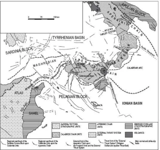
The geodynamic frame encloses the following structural domains: the foreland, the orogenic, and the hinterland domains (Ben Avraham et al., 1990; Lentini et al., 1996; Finetti et al., 1996). The foreland domain is represented by the Apulian and Pelagian Blocks, characterized by continental crust and by the Ionian Basin (Fig. 1.1), whose old oceanic crust has been partially consumed under the orogenic arc. The orogenic domain is composed of three superimposed tectonic belts: the External Thrust System that is the lowermost tectonic element, on which the Apenninic-Maghrebian chain overrode, and finally the Calabride chain lying at the top (Fig. 1.2). Finally, the hinterland domain is represented by the Tyrrhenian Basin, whose abyssal plane is made of new oceanic crust (Fig.1.1) (Ben Avraham et al., 1990; Lentini et al., 1996; Finetti et al., 1996).
Lentini et al. (2002) recognized two tectonic phases responsible of the orogenic domain building, characterized by compressive deformation tied to a thin-skinned tectonic context and that lead to the formation of two tectonic wedges. The first orogenic phase caused the development of the more ancient accretionary wedge, the origin of the Liguride- Sicilide nappes (late Oligocene–early Miocene), due to the subduction of the Tethyan Ionian oceanic crust and to the collision between the European margin and the “Maghrebian” continental crust, originally located between the Tethys and the Ionian oceanic crusts. The second orogenic phase occurred from middle Miocene times with the opening of the present-day back-arc Tyrrhenian basin and, at the end of Pliocene, the consumption of part of the Paleo-Ionian oceanic crust and the collision of the “Maghrebian” continental crust with the Africa and Adria ones (Finetti et al., 2005a).
1. Geological and seismological features of Sicily
Fig: 1.1: Regional distribution of the structural domains in the central Mediterranean (after Lentini
et al., 1996).
1.1Geological and structural setting of eastern Sicily
In the eastern sector of Sicily, the foreland domain includes the currently undeformed continental areas of the Pelagian Block and, more at east, the Ionian basin. The Pelagian
1. Geological and seismological features of Sicily
Tesi di dottorato in “Evoluzione geologica di orogeni di tipo mediterraneo” di Claudia Pirrotta
3 Mesozoic–Cenozoic shallow-water to basinal carbonatic sedimentary succession, with repeated intercalations of volcanites (Fig. 1.3). The Pelagian Block is separated to the east from the Ionian Basin by a north-south-trending tectonic discontinuity, the Hyblean- Maltese escarpment that partially affected the original margin of the Block and was responsible for the progressive collapse of its eastern margin facing the Ionian basin (Carbone et al., 1982a; Grasso and Lentini, 1982). The Hyblean- Maltese system, characterized by prevalently normal faults, was active during the Pliocene and the Quaternary (Scandone et al., 1981; Fabbri et al., 1982; Casero et al., 1984) and it also involved the eastern slope of Mount Etna volcano and seems to plays an important role in the seismotectonic evolution of the area (Carbone et al., 1982; Monaco et al., 2005). The Pelagian Block is divided into an uplifted element, the Hyblean plateau (Fig. 1.3) and a sector flexured north-westward below the tectonic units of the orogenic domain. The two sectors are separated by a system of northeast-southwest-oriented normal faults that delimit the Gela foredeep, which is fully occupied by the allochthonous units of the front of the chain, the Gela nappe (Bianchi et al., 1987; Grasso et al., 1990). The Hyblean plateau has been characterized by intermittent volcanic activity from the Triassic up to the early Pleistocene. The late Pliocene activity was marked by a drastic compositional change from mafic alkaline to tholeiitic and by the eruption of large volumes of lava.
Figure: 1.2: Southwest-northeast-oriented schematic cross section of the southern Apennines showing the
structural domains of the Apenninic-Maghrebian orogen (after Lentini et al., 1996).
This activity occurred when the north-western sector of the Hyblean foreland collapsed and the normal fault system developed, originating the foredeep (Behncke, 2001). The
1. Geological and seismological features of Sicily
younger volcanic units of the northern margin of the Hyblean foreland indicate a shift of the volcanic activity toward the Etna area.
The peculiarity of the orogenic belt mainly lies in a general duplex geometry, where the roof thrust system, some thousand meters thick, is composed of the allochthonous units of the Apenninic- Maghrebian chain, while the floor thrust is represented by the External Thrust System (Fig. 1.2). This latter has been generated by the detachment of the more or less rooted carbonate, representing the internal sedimentary covers of the flexured sector of the continental foreland. In Sicily it formed at the expense of the Africa plate covers and is represented by the Pelagian-Sicilian thrust belt, exposed in western Sicily (Pelagian-Sicilian thrust belt) where it consists of shallow-water (Triassic–Liassic) and pelagic carbonates (Middle Jurassic to early Oligocene) and of continental shelf to slope syntectonic terrigenous deposits (late Oligocene to early Tortonian). In the eastern sector of Sicily it is buried below the unrooted nappes of the Apenninic-Maghrebian chain and has been detected at high depth only in seismic lines.
The Sicilian Apenninic-Maghrebian chain widely overthrust the Pelagian-Sicilian thrust belt and in some cases tectonically overlies the margin of the foreland with the Gela nappe. This chain, forming an imbricated thrust system, originated in the late Oligocene, first at the expense of the sedimentary sequences that floored the oceanic crust of Tethys, the Alpine Tethys basinal sequences (Sicilide Units). Successively, since the middle Miocene, it formed through tectonic denudation of continental crust sectors due to the orogenic transport of the allochthonous carbonatic covers (the Panormide-Apenninic carbonate platforms) onto the Ionian basinal successions (the Ionides), interpreted as the original deposits of branches of the Paleo-Ionian basin (Lentini et al., 2002; Finetti et al., 1996).
The Calabride chain is constituted by the European margin delamination products and partially from those of the Austroalpine belt (Fig.1.3).
1. Geological and seismological features of Sicily
Tesi di dottorato in “Evoluzione geologica di orogeni di tipo mediterraneo” di Claudia Pirrotta
5 the coastline of Sicily, Calabria and of the southern Apennine, corresponds to a paleoforearc basin developed since the late Miocene above the back-stop of the chain and the accretionary wedge (the Calabrian arc) (Guarnieri, 2005; Lentini et al., 2006).
Fig. 1.3: Geological map of Eastern Sicily (after Lentini et al, 1996).
Present day geological setting of eastern Sicily is linked to the migration of the Apenninic-Maghrebian Chain front toward the Hyblean Plateaux, the collision between the orogenic back-stop and the Africa continental crust, the retreat of the Ionian subduction hinge (Malinverno and Ryan, 1986; Patacca and Scandone, 1989), and the roll-back of the African and Adriatic plates (Doglioni et al., 1994; Guarnieri et al., 2002). The collision continental, that results diachronous from west to east, began in late Tortonian times and has given rise to a transpressive tectonics with dextral movements (Ben Avraham et al.,
1. Geological and seismological features of Sicily
1990). In northern Sicily and its off shore, transpressive and transtensive tectonics is accommodate by a complex structural systems acting at different crustal levels (Finetti et al., 1996; Del Ben and Guarnieri, 2000). The superficial expression of the present collisional stage is the northwest-southeast right transcurrent fault system, named South Tyrrhenian System (Finetti et al., 1996). These structures caused differential shortening in the collisional margin, accompanied by the southeast-ward migration of the orogenetic front of the Calabrian Arc toward the Ionian basin (Lentini at al., 1996).
The retreat of the Ionian subduction hinge and the roll-back of the African and Adriatic crusts caused, in the sector containing the forearc basin, the collapse and the development, from the late Pliocene onward, of the present peri-Tyrrhenian margin (Guarnieri, 2005). Since late Pliocene– early Pleistocene times, an early southeast-ward migration of the subduction hinge has been accompanied by the development of NW-SE -trending tear faults and northeast-southwest-trending extensional systems. During middle–late Pleistocene times new NNW-SSE -trending tear faults (the Volcano and Catanzaro lines) (Fig. 1.1) and N70°E-trending collapse systems developed probably as a consequence of a second SSE-ward retreat of the subduction hinge that led to the structural reorganization of a new back-stop and a corresponding collapse behind it.
The remains of a Paleo-Ionian slab, probably deactivated, are detected by north-south-oriented offshore seismic lines close to the Palermo coastline; moving progressively toward eastern Sicily, the same old slab is recognizable in onshore seismic lines (Lentini et al., 2006). To the east of the Vulcano line, in north-eastern Sicily and southern Calabria, where the foreland is represented not by a continental crust but by the Ionian oceanic crust, the seismic imaging shows the subducted upper Ionian slab and highlights that no collisional setting occurs here. Deep seismicity of the Tyrrhenian Sea also confirm the presence of a north-westward subduction slab (Giardini and Velonà, 1991), while the absence of earthquakes up to 200 km below northern Calabria implies the presence of Tyrrhenian
1. Geological and seismological features of Sicily
Tesi di dottorato in “Evoluzione geologica di orogeni di tipo mediterraneo” di Claudia Pirrotta
7 most recent evolution phase of eastern Sicily and southern Calabria. According to this model an incipient Rift Zone affects this area and it manifests by a normal fault belt that runs from the Crati Valley (southern Calabria) to the Hyblean Plateau (south-eastern Sicily) for a length of about 370 km. The rift process developed since about 500 kyr, following the end of the subduction of Ionian lithosphere beneath the Calabrian arc (Wortel and Spackman, 1993; Westaway, 1993), in response to the large scale motion (Ward, 1994) characterizing the two blocks dissected by the rift zone.
The faults border the main Plio- Pleistocene basins of the region (Crati basin, Mesima-Gioia Tauro basin, Messina Strait) and they also control the eastern Sicily coastline, bordering wedge-shaped extensional basins in the Ionian offshore (Scandone et al., 1981; Casero et al., 1984; Monaco et al., 1995; Hirn et al., 1997; Bianca et al., 1999). On shore, the faults deform Upper Pleistocene-Holocene sediments and exhibit steep linear escarpments and typical geomorphologial features such as triangular and/or trapezoidal facets. This tectonics also seems to have reactivated pre-existing structures, as the northernmost portion of the Malta Escarpment Fault System as shown by the distribution of the crustal seismicity. Most of the events that have occurred in this area are located in the hanging walls of the main Quaternary normal faults thus suggesting a strong relationship between seismic activity and the growth of extensional structures (Monaco and Tortorici, 2000). Furthermore, these faults are considered to be responsible for the middle Pleistocene-Holocene volcanism of the eastern sector of the Aeolian archipelago (Stromboli, Salina, Lipari and Vulcano) and of the Mt. Etna (Mazzuoli et al., 1995; Tortorici et al., 1995; Monaco et al., 1995, 1997).
1.2Eastern Sicily historical earthquakes and related seismogenic sources
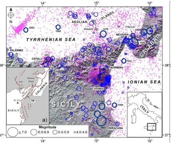
Eastern Sicily falls on an almost continuous seismogenic belt capable of producing M ~ 7 earthquakes and that extends from the Calabrian Arc through the Messina Straits, as far as south-eastern Sicily (Fig. 1.4). According to the Italian earthquake catalogue (CPTI04 Working Group, 2004) some of the last millennium’s most destructive earthquakes (Io > X
1. Geological and seismological features of Sicily
MCS) are located along the southernmost part of the Calabro–Peloritan Arc (1783, 1894 and 1908 earthquakes) and in south-eastern Sicily (1169, 1542 and 1693 earthquakes) (Fig. 1.4).
Fig. 1.4: Southern Tyrrhenian Sea and eastern Sicily epicentral map showing the location of historical
earthquakes, blue circles (data from CPTI Working Group 2004) and the instrumental seismicity (2.2 ≤ ML≤ 4.0) from 1983 to 2002, full dots (data from Castello et al. 2005) (after Azzaro et al., 2007, modified).
Sources parameters for most of these events were assessed on the basis of historical macroseismic data and some Authors tried to realize source models combining macroseismic data with geological and geomorphological evidences (Fig. 1.5, 1.6)
1. Geological and seismological features of Sicily
Tesi di dottorato in “Evoluzione geologica di orogeni di tipo mediterraneo” di Claudia Pirrotta
9 location. This uncertainty is mainly due to the fact that the majority of the earthquakes occurred before the seismic instruments development and without clear and unquestionable surface faulting evidences.
Fig. 1.5: Relationship between Quaternary faults and earthquakes (M ≥ 4); epicentres from
CPTI04 (Working Group, 2004) (modified from Monaco and Tortorici, 2000).
Meletti (2008), reviewing existing models available for Italy and Europe countries, recently presented a new seismogenic model, termed ZS9, based on historical earthquakes data, instrumental seismicity, active fault models and seismotectonic evidence from recent earthquakes (Fig. 1.7). In this model Sicily encloses five seismic source zones (Fig. 1.7a).
The DISS database 2009 (Working Group, 2009) brought together a large amount of published and original data along with geographic, seismological, geological and tectonic
1. Geological and seismological features of Sicily
information defines the seismogenic sources, having a potential for a M > 5.5, for the whole Italian country and for Sicily (Fig. 1.7).
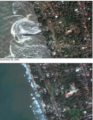
North-eastern Sicily was hit by the strong December 28th 1908 earthquake (Mw = 7.2, Boschi et al., 2004) that was one of the most disastrous event never occurred in the Italian history. It caused the complete disruption of the Messina and Reggio Calabria cities and widespread damage in several localities of Sicily and southern Calabria. Moreover 40 feet (12 m) high tsunami struck nearby coasts causing even more devastation (Baratta, 1909).
Models proposed for this event generally locate the source in the Messina Strait (Fig. 1.5, 1.6 and M1 and M2 in Fig. 1.7 b). Proposed faults are all normal one, but they differentiate for the strike and dipping (Fig. 1.6). However, the most accepted model is that of a crustal blind E-dipping, low-angle, normal fault, with a minor strike-slip component (Pino et al. 2000). Bottari et al. (1986), on the basis of macroseismic data, considered a northeast-southwest striking fault with west dipping directions. On the basis of levelling data inversion Capuano et al. (1988), Boschi et al. (1989) and De Natale and Pingue (1991) performed source models involving east-dipping faults characterized by low dipping angles (30-40°), differing mainly for the strike direction and fault dimensions. Valensise and Pantosti (1992) hypothesize a source dipping mainly toward east that would be responsible of the 125-ka marine terrace deformation and uplift on both the side of the Messina Strait. On the basis of geological and morphological data Monaco and Tortorici (2000) consider a north-south to northeast-southwest striking fault with west-northwest dipping directions as responsible of this event (fig. 1.5). A further model proposed by Jacques et al. (2001) considers a southwest dipping normal fault (M1 in Fig. 1.7b).
1. Geological and seismological features of Sicily
Tesi di dottorato in “Evoluzione geologica di orogeni di tipo mediterraneo” di Claudia Pirrotta
11 Fig. 1.6: Source models proposed for the 1908 earthquake (after Pantosti and Valensise, 1992).
The 1783 Calabrian seismic sequence (5.9 ≤ Mw≤ 6.9) caused very strong earthquakes occurred in a short span time (February-March) and it was able to damage several places of north-eastern Sicily. The second event of this sequence, occurred on February 6th, caused a big landslide-induced tsunami. A possible source proposed for this earthquake is the Scilla fault (SF in Fig. 1.7b) (Jacques et al., 2001). A further strong Calabrian event causing damage in Sicily was the 1894 earthquake (Mw = 6.0).
Meletti (2008) included the earthquakes of southern Calabria and northeastern Sicily into the 929 zone, characterized by a seismically active set of approximately NNE-SSW trending extensional faults (Tortorici et al., 1995, Monaco and Tortorici, 2000, Monaco et al., 1997) (Fig. 1.7b). This zone involves the Crati, Savuto areas, the Mesima basins and the Messina Straits.
Moreover, the faults of southern Calabria and northeastern Sicily have also been associated with the DISS09 (Working Group, 2009) source zone named ITCS069-Southern
1. Geological and seismological features of Sicily
Calabria (A in Fig. 1.7a) enclosing the source of the February 6th 1783 and 1908 earthquakes (SF and M1 respectively, in Fig. 1.7b).
Fig. 1.7: a) Google Earth Map and
some seismogenic sources proposed in literature: white dashed lines delimitate the seismogenic zones by Meletti el al. (2008); orange areas are seismogenic zones by DISS09 (Working Group, 2009); rectangle is the location of figure b; b) seimogenic source models compared with epicentre location of some of the strongest historical earthquakes, marked by circles: unfilled circles from the CPTI4 catalogue (Working Group, 2004) and filled circles from the NT4.1 catalogue (Camassi and Stucchi, 1997). Possible source proposed for the February 6th 1783 earthquake is the SF = Scilla fault (Jacques et al., 2001); for the December 28th 1908 earthquake the M1 = Straits of Messina fault (Jacques et al., 2001) and M2 = Straits of Messina fault (DISS Working Group, 2009 and references therein). For south-eastern Sicily red circles indicate two different source models for the February 4th 1169 event, yellow circles indicate that proposed for the January 11th 1693 event; green circle indicates the location of the
1. Geological and seismological features of Sicily
Tesi di dottorato in “Evoluzione geologica di orogeni di tipo mediterraneo” di Claudia Pirrotta
13 The north-eastern sector of Sicily, between Messina and Cefalù, suffered some comparatively minor earthquakes such as that of the 1786 (Mw = 6.0), the 1823 (Mw = 5.8) and the 1978 Patti Gulf earthquake (Mw=6.1) (Fig. 1.4). Some of these events was considered in the 932 source zone of Meletti (2008) (Fig. 1.7a), enclosing the transfer faults that accompany the slab retreat beneath the Calabrian Arc plus the faults responsible for the segmentation of the E–W Cefalù basin and Patti Gulf. Some of these faults are also enclosed into the ITCS042- Patti Eolie zone of the DISS09 (B in Fig. 1.7a).
Zone 933 (Fig. 1.7a) partially overlaps with the Mt. Kumeta–Alcantara fault system, a large and presumably active corridor that extends between Mt. Etna and Palermo. This relatively low-seismicity zone, originally proposed by Ghisetti and Vezzani (1984), is characterised by extensional and strike-slip kinematics, but its geometry is not very well defined from the point of view of active tectonics. This zone collects a number of historical earthquakes, e.g. the September 1st 1726 (Mw 5.6), the March 5th 1823 (Mw 5.9) and the January 15th
1940 (Mw 5.3).
The southernmost sector of the Tyrrhenian sea is characterized by a seismogenic belt named F zone by Meletti (2008) and ITSA014 Southern Tyrrhenian according to the DISS09 (C in Fig. 1.7a). This zone, that also comprises part of the western Aeolian seismicity, includes some events of the instrumental era such as the September 6th 2002 earthquake (Mw 5.9), that caused minor damage to Palermo (Azzaro et al., 2003), and other relatively large events (Pondrelli et al., 2004; Vannucci et al., 2004).
Moreover, this zone could include some significant historical earthquakes whose sources are currently located inland, in the Zone 933, but with high uncertainty. Indeed location of these events is based on the modelling of intensity pattern (Gasperini et al., 1999), but unfortunately the computer code used for this reconstruction has a known tendency to place on the coastline earthquakes that occurred offshore. As showed by the case of the 2002 earthquake, the lack of intensity points offshore causes the shift onshore of the epicentre (Azzaro et al., 2004). Even if there aren’t strong enough historical evidence to relocate offshore the strongest earthquakes occurred in this area in the past centuries, several Authors considers that these events may be ascribed to offshore seismic sources as strongly supported by the distribution of the instrumental seismicity of the last two decades,
1. Geological and seismological features of Sicily
that defines a cluster of earthquakes along an E-W trending strip, developing north of the Sicilian coast (Azzaro et al., 2004).
The March 5th 1823 earthquake (Mw 5.9) heavily afflicted Palermo and it also damaged sites further east in a large area along the Tyrrhenian coast (Imax = 8–9 MCS) and was felt almost throughout the whole of Sicily (Boschi et al., 1995). The macroseismic epicentre of this event proves to be inland near Cefalù and was hardly related to the activation of inland structures on the basis of the elongation and asymmetry of its intensity pattern. Recently the hypothesis that the epicentre of this event could be located off shore on the Tyrrhenian Sea and that its parameters could have been underestimated was advanced (Azzaro et al., 2004; Meletti, 2008). According to Meletti (2008) if this earthquake occurred in zone F, its magnitude would has been underestimated and should hence be reassessed. For instance on the basis of scaling relationships derived for the 2002 earthquake (observed Mw 5.9; intensity-based Mw 5.1) the 1823 earthquake would have magnitude reaching 6.7.
In western Sicily the almost W-E seismogenic zone of DISS09 named ITSA021 Marsala Belice (D in Fig. 1.7a) partially corresponds with the about NNE-SSW-trending, 934 zone, by Meletti (2008) (Fig. 1.7a). In this zone only one destructive sequence occurred: the Belice seismic period that started on January 13th 1968 (Mw 6.1). However different seismotectonic hypotheses have been performed on the basis of geological investigations (Michetti et al., 1995; Monaco et al., 1996). Some Authors consider that this seismogenic area represents a portion of foreland affected by large strike-slip faults and that the source of these events is part of a “flower” structure belonging to this system. Another hypothesis considers the source as a S-verging blind thrust having an E–W direction (Valensise and Pantosti, 2001). However, no conclusive evidence on the location and geometry of the causative source has been given.
The southernmost belt of Sicily encloses the ITSA006 Castelvetrano-Gela seismogenic area (DISS09, Workink Group, 2009) (E in Fig. 1.7) linked to the Apenninic Maghrebian
1. Geological and seismological features of Sicily
Tesi di dottorato in “Evoluzione geologica di orogeni di tipo mediterraneo” di Claudia Pirrotta
15 and raised terraces, some Authors observe evidence of abrupt vertical movements and propose them as consequence of repeated coseismic displacements due to the motion of seismogenic faults belonging to the Siculo Calabro Rift Zone (Stewart et al., 1997; De Guidi et al., 2003). These faults would be responsible of three events in the past 5 ka, the strongest of which (M ~ 7) was dated at about 3.2 ka (De Guidi et al., 2003). However, the seismicity of this sector was recently revaluated. Indeed, the location of March 28 th 1780 event, originally established near Messina, was reconsidered by Azzaro et al. (2007) after a systematic analysis of the 18th century journalistic sources (gazettes). According to the new model this event was considered as the main shock of a seismic sequence located on the Ionian coast of north-eastern Sicily. Therefore, different epicentral parameters and a higher macroseismic magnitude (Io = VII–VIII MCS, Mw = 5.6) were considered for this event.
More at south, the Etna region represents one of the most active volcanic areas worldwide, characterized by moderate (2,9< M< 4.8) shallow (H < 5 km) earthquakes (Fig. 1.4) producing macroseismic intensities reaching even the IX-X grade (MSK) an occurring with short recurrence time (tens of years) (Azzaro, 1999). According to Meletti et al. (2008) the source zone surrounding Mt. Etna volcano (936 in Fig. 1.7) includes seismogenic features completely different from the rest of Sicily linked to the volcanic activity. Recent studies have been devoted to the clarification of the relationships between tectonics and shallow sesmicity in this area (Lo Giudice and Rasà, 1992; Gresta et al., 1997; Monaco et al., 1997) but at the present these relationships are not well defined. However, the earthquake occurred on February 20th 1818 in this area has been considered a tectonic event, that could be related to a segment of the Maghrebide thrust system as already hypothesized by Lavecchia et al. (2007).
In south-eastern Sicily, nearly 60% of the accumulated strain has been released by only few large earthquakes during the last millennium, the February 4th 1169 (Mw = 6.6, Working Group CPTI, 2004), the January 9th 1693 (M= 6.2) and the January 11th 1693 (M= 7.4, Io up to XI MCS, Working Group CPTI04, 2004) earthquakes.
The large 1169 earthquake (Fig. 1.4; 1.5; 1.7b) was one of the strongest events, it is among the better described by the historical reports and hit with high intensity
south-1. Geological and seismological features of Sicily
eastern Sicily causing large damage. This strong earthquake was also followed by a disastrous tsunami.
The January 11th 1693 earthquake and its large January 9th 1693 foreshock (Fig. 1.4; 1.5; 1.7b) belong to a long seismic period that destroyed several localities of Eastern Sicily. Numerous descriptions of damage and ruins are reported by the historical sources for these events that were felt in the whole Sicilian country and also caused a damaging tsunami.
The December 10th 1542 earthquake (Mw = 6.6) (Working Group CPTI, 2004) was less strong but however damaging and was also followed by a strong tsunami. It represents the main shock of a seismic period that started in the last day of November and lasted 40-days (Chronaca Siciliana, 16th century). Damage related to this event, run from the Ionian coast up to Caltagirone in the central part of Sicily.
Given the lack of surface faulting evidence, the sources of the previously described earthquakes have been approximately located in the southern sector of eastern Sicily and tentatively associated to some active faults observed by geological- structural and geomorphologic approaches or modelled by processing levelling data and macroseismic data analyses (Fig. 1.5 and 1.7b).
The 935 zone proposed by Meletti et al. (2008) (Fig. 1.7a), enclosing the Hyblean Plateau area and whose eastern boundary coincides with the Malta Escarpment, hosts some destructive events of south-eastern Sicily such as the previously described January 9th 1693 and January 11th 1693.
The DISS09 associated the 1169, 1693 and 1818 events to the ITCS029 Gela –Catania Seismogenic source (F in Fig. 1.7a), located along the NE-SW trending outermost front of the Maghrebian thrust belt and running along the inner margin of the Gela- Catania foredeep. Moreover, the January 11th 1693 quake is also associated to the ITIS036 source named Monte Lauro (I in Fig. 1.7). However, according to DISS09 the Hyblean Plateaux is characterized by other seismic areas that could enclose the important events occurred in
1. Geological and seismological features of Sicily
Tesi di dottorato in “Evoluzione geologica di orogeni di tipo mediterraneo” di Claudia Pirrotta
17 Several authors proposed source models for the January 11th 1693 earthquake, associated both with inland active faults and with the off-shore fault system of the Malta Escarpment. On the basis of geologic, geomorphic or macroseismic intensity analysis D’Addezio and Valensise (1991) consider an on-land normal fault within the Scordia-Lentini graben as the seismogenic fault (L1 and L2 in Fig. 1.7b). Valensise and Pantosti (2001) suggested that this earthquake was caused by a splay of the NNE-SSW Scicli– Ragusa fault system (SR in Fig. 1.7b). This hypothesis had already been put forward by Sirovich and Pettenati (1999)that associate this event to a blind strike slip fault, parallel to the Scicli line (SL in Fig. 1.7b) and was also backed by the work by Barbano and Rigano (2001). Current seismic activity of the inner Hyblean Plateau is also supported by large-scale tectonic reconstructions (Bousquet and Lanzafame, 2004) and seismological data (Musumeci et al., 2005), while the left-lateral reactivation of the southern portion of the Scicli–Ragusa fault is the object of ongoing field investigations (Catalano et al., 2006). A further recent interpretation considers the likelihood of two main shocks during the January 11th 1693 associated to two different compressive seismogenetic sources at south and at north of the Catania Plain. The southernmost one is the NNE-SSW trending, left-lateral strike-slip fault running through the Hyblean region, partially coinciding with the Mt. Lauro Fault (ITIS074 according to the DISS08; Basili et al., 2008); the northernmost proposed source is the Gravina di Catania Fault (ITIS106 according to the DISS08; Basili et al., 2008), a northeast southwest trending, low-angle thrust recognised at the front of the Maghrebian Thrust Belt. This thrust probably represents the superficial expression of a major seismogenic source located on the north of the Catania Plain (Sleiko and Valensise, 2007).
The off-shore models for the 1693 earthquake are based on tectonic and seismic prospecting data analysis and suggest the rupture of a segment of the Hyblean-Malta escarpment (ME in Fig. 1.7b) (Azzaro and Barbano, 2000; Jacques et al., 2001) or of a locked subduction zone fault, part of the Ionian slab, more at south-east (Gutsher et al., 2006).
2. Earthquake Geology
2.EARTHQUAKEGEOLOGY
“Enormous landslides fall on farms; entire towns come down for soil downfall; scary sea waves take away builds, people and everything that they meet along the way; large potholes opened getting down carts, farmers and animals; glows lighted up the nocturnal sky transforming the night to day, the water became red in colour and the air became unhealthy” (Bonito, 1691; Mongitore, 1743; Longo, 1908; Baratta, 1909). All these phenomena are described, since old time, by witnesses during strong earthquakes worldwide and they frightened people also fomenting beliefs and superstitions. Today these effects are better known and carefully studied by the scientific community also because they can represent the first cause of damage during the earthquakes.
Indeed, strong earthquakes, generally with M>5, are capable to produce effects on the geology and geomorphology, like ground fracturing and opening, dislocation and tilting, landslides, tsunamis and effects on the rivers and aquifers. Many of these geologic structures can rest recorded as fossil marker of seismicity, testifying the occurrence of past earthquakes. These fossils are generally defined by the international scientific community seismites (Seilacher, 1969; Vittori et al., 1991) and are investigated by means of Paleoseismological studies.
Since Paleoseismology is a young discipline of Earthquake Geology, more than a classification has been given by the literature for the seismites. However, an absolute distinction in classes is not always easy also because the seismites often occur contemporary and the relationships with the seismogenic source can be not clear. Nevertheless, a division in category is necessary because the paleoseismological approaches change on the basis of the seismite typology.
Vittori et al. (1991) define as seismites any geologic effects produced by earthquakes.
2. Earthquake Geology
fault, and “secondary effects” that are indirectly linked to the fault activity, because they are not trigger by the fault movement but by the seismic shaking and the seismic wave propagation in the sediments. Both the effects can have consequences on the geomorphology and the stratigraphy (Tab. I) (McCalpin and Nelson, 1996).
Tab. I Hierarchical classification of seismogeological effects according to McCalpin and Nelson (1996)
modified and simplified; letters at the apex refer to the Michetti’s (1991) classification.
On fault Off fault
Primary Geomorphic effects Fault scarpC FissuresC FoldB MoletracksB Pressure ridgesB Stratigraphic effects Faulted strataC Folded (tilted) strataB Colluvial wedge Fissure fillsA/C
Geomorphic effects Tilted surfacesB Uplifted shorelinesB Drowned shorelinesB Stratigraphic effects Tsunami deposits Secondary Geomorphic effects
Sand blows (liquefaction) A LandslidesA
Stratigraphic effects
Sand dykesA
Rapidly deposited lake or estuarine sediment
Geomorphic effects
Sand blows (liquefaction)A LandslidesA
FissuresA
Stratigraphic effects
Sand dykesA TurbiditesA
Seismites can also be divided in those developing on the fault (on-fault seismites) and those developing at some distance from it widespread in the epicentral area (off-fault seismites) (Tab.I).
Another distinction can be performed on the basis of the time when the effects develop. Primary effects can be defined “short term primary effects” because they occur contemporary to earthquake happening; these effects can be surface faulting, including permanent displacement (uplift and subsidence). Secondary effects can be “short term” effects if they occur suddenly and like contemporary or short time after the quake occurrence. These effects include liquefaction, landslides, tsunamis and floods. Secondary effects, linked to the tectonic processes for which the earthquake occurred and that develop slowly during the time, are defined “long term secondary effects”. These include deformation developing at regional scale, linked to subsidence or uplift of
2. Earthquake Geology
landmasses and regional change in groundwater levels, or modification of the fluvial network (Keller and Pinter, 1996).
2.1 Primary effects
Fault movement during the earthquakes can produce geomorphologic modifications in proximity of the fault itself or far from it. Scarp development, fissures, fold occur as on-fault geomorphologic structures. Vertical deformation, including both uplift or subsidence and ground surface tilting can occur no many far from the fault as off-fault geomorphic effects. The slip along the fault can also perturb the equilibrium of geomorphologic elements and produce anomaly of the geological processes causing their acceleration or modification in the tentative to restore equilibrium. Fluvial network, fluvial or marine terraces or lakes are particularly prone to these modifications (Tab. I). Indeed, river systems are the most sensitive elements capable of quick adjusting both over periods of decades and of centuries (Keller and Pinter, 1996).
Fault movement and dislocation cause on the stratigraphic sequence effects like faulted, folded or tilted strata; fissure fills; colluvial wedges due to the acceleration of erosional/depositional processes in effort to restore equilibrium (on-fault stratigraphic structures). Moreover, off shore fault displacement can produce a tsunami that can left a particular deposit in the stratigraphic sequence named tsunamiite (off-fault stratigraphic structures) (Tab. I).
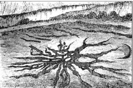
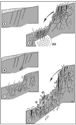
Surface fault rupture is the manifestation of the displacement where the fault slip extends up to the ground surface. In the international literature the term “surface faulting”, or “earthquake fault”, corresponds to the whole of tectonic dislocation (scarps, fractures, downwarping and upwarping) that generally form on the ground surface as a consequence of strong crustal earthquakes (Fig. 2.1) (Michetti, 1994).
2. Earthquake Geology
IAEA 1991, 2002). This fault can also be an active fault if it moved during the past 10ky and if it is capable to move with potentially damage effects in a span of time of social interesting. Moreover, a capable and active fault can also be a seismogenic fault if it has produced at least an earthquake in historical time and in a span of time of social interest, detectable on instrumental bases or of macroseismic data (analysing the historical data on damage and on the effects at the surface which allow to define the macroseismic epicentral area). However, capable and active faults can be non seismogenic if they are only physically linked to the seismogenic one and moves during an earthquake with it, but their fault plane doesn’t embody the quake focus.
Surface faulting is the most relevant among primary earthquake effects, because the detection and successive study of the seismogenic source, and/or other faults physically linked to it, allow obtaining information on the seismic history of that source useful to know future earthquake occurrence (paleoseimological on-fault study, see chapter 3).
Generally, fault rupture reaches the surface only during moderate- to large-magnitude earthquakes with a hypocentre depth of less than 15-20 km and large-magnitudes greater than 6.5 (Bonilla and Buchanan, 1970). Surface faulting length may range from a fraction of an inch to 80 km (in some cases over 200 km) (Fig. 2.1) and offsets up to several meters (about 4-7 m) (Fig. 2.2) in a narrow zone along the main fault trace, depending on the earthquake magnitude, steepness of the fault plane, type of movement and so on. These same factors, as well as the nature of the geologic materials, also influence how wide the zone of surface rupture is likely to be (Pantosti and Yeats, 1993).
Fig. 2.1: Surface faulting of the 1915 Pleasant Valley Earthquake, Nevada (M= 7.5)
2. Earthquake Geology
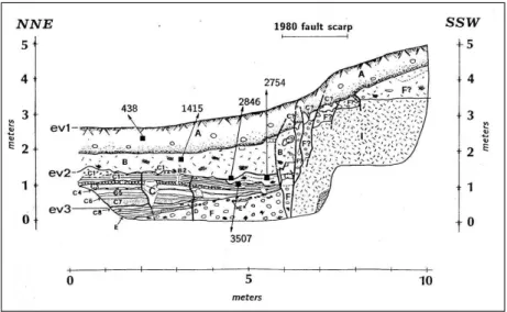
Fig: 2.2: Fault scarp of the Irpinia 1980 earthquake (from
Pantosti et al, 1993).
In particular areas, such as volcanic zones (e.g. Mt. Etna) surface faulting occurs for low magnitude threshold, even less than 4, due to local unusual tectonic conditions (Buchanan-Banks, 1987; Rasà et al, 1996; Smith et al., 1996). These areas are also characterized by very shallow seismic sources (h < 2 km) and low stress-drops.
Not all moderate-to large-magnitude earthquakes produce fault slip at the ground surface. In some cases, the fault displacement may occur entirely at depth, with little or no apparent permanent surface deformation (e.g., 1989 Loma Prieta, California earthquake of Mw 7.0) or with more subdued or diffuse surface warping and fracturing (as the 1994 Northridge, California earthquake of Mw 6.7). However, these earthquakes can produce at the surface other effects on geology and geomorphology (see also Paragraph 2.2).