V
V
o
o
l
l
.
.
1
1
5
5
,
,
N
N
o
o
.
.
4
4
2
2
2
0
0
2
2
0
0
_________________________________________________________________________________
Table of Contents A. Guarducci, G. Tarchi
The first geodetic map of the Grand Duchy of Tuscany georeferencing and applicated studies, 168-182
A. Sen
Comparison of Past and Present Maps of Istanbul Historic Peninsula in GIS, Based on the Insurance Maps of Jacques Pervititch, 183-198
E. Livieratos, C. Boutoura
The Ing. Raseau manuscript large-scale maps of Cyclades, a case of French military thematic cartography of late seventeenth century with remarkable aesthetic value, 199-212
Á. Bachiller, C. Soteres, J. Sánchez, A. Sánchez, P. Abad, G. Cano, G. Andrés, C. Ruiz, E. López
Web Map Services publishing Ancient Maps. Merging past and new technologies, 213-225
__________________________________________________________________________________
Editorial Board
Editors: P. Falchetta (Venice); E. Livieratos (Thessaloniki); C. Monti (Milan); G. Tolias (Athens) Consulting Editors: P. Gautier Dalché (Paris); F. Guerra (Venice); C. van den Heuvel (Amsterdam); C. Montaner (Barcelona); C. Boutoura (Thessaloniki); C. Balletti (Venice); C. Tonini (Venice), A. Koussoulakou (Thessaloniki)
[168]
Anna Guarducci , Giulio Tarchi
The first geodetic map of the Grand Duchy of Tuscany georeferencing and
applicated studies
Keywords: Grand Duchy of Tuscany, XIX century, first geodetic map, georeferencing
Summary: In the 1830s and 1840s Giovanni Inghirami created a map with a 1:100,000 scale, using and
updating the maps of the geometric cadastre of land parcels; there are two manuscript versions of this map preserved respectivtly in the IGM - Geographic Military Institute of Florence and the National Archives in Prague.
The Lorraine government, only after the 1848 revolution, however, accepted this project, when the Military Topographic Office was founded. This Office was only able to begin the operation for a portion of the north-western territory of the Grand Duchy.
After making the Chorography map of Tuscany, in the scale of 1:200,000 (1830-1831), the astronomer, surveyor and cartographer Inghirami invented a larger scale topographic map; he based his invention on the French Cassini model because the map could be better applied to the needs of city-planning and territorial policies. This is an extraordinary cartography (representation), able to provide useful documentation to anyone (geographer, historian, architect, urban planner etc.) who wants to study the territory with geo-historical purposes.
The georeferencing of this map was made with use of the Carta d’Italia produced by the Geographic Military Institute of Florence, during the preparation of the Tuscany Regional Government Landscape Plan, has revealed extraordinary potential applications. In fact, the georeferencing allows one to identify the landscape-territorial organization and specific historical themes (settlements, roads, river basin planning, municipal administrative boundaries, toponymy, etc.) that developed during this extensive period, almost until the national unification. Such content can be used to prepare government plans for territorial management in order to preserve and enhance cultural and landscape heritage.
Introduction
The manuscript representation presented here comes from the first geometric map of the Grand Duchy of Tuscany to the topographic scale (1:200,000) manufactured and printed in 1830-31 by the Florentine astronomer, surveyor and cartographer Giovanni Inghirami.1 This important
representation - in spite of the strong will of the Lorraine Grand Dukes to own an authentic map of the State for political, administrative as well as scientific and cultural purposes, and despite the efforts of the most talented scientists and cartographers that from the 40s of the eighteenth century were challenged to its completion - came to fruition only after the first general geometric-particle land registry. Until then, in fact, that undertaking had been hindered by the insufficient level of knowledge of the absolute measurements of the geographical coordinates and the numerous
Both authors at the Dipartimento di Scienze Storiche e Beni Culturali, University of Siena [[email protected]]
1 Carta Geometrica della Toscana ricavata dal vero nella proporzione di 1:200000 e dedicata a S.A.I. e R.
Leopoldo II Principe Imper.le d’Austria [...], dal suo ossequiosissimo servo, [...], Giovanni Inghirami delle Scuole Pie Fiorentine (Florence, Biblioteca dell’Istituto Geografico Militare), Copper engraving, in 4 sheets mounted on canvas, size 70x54 cm each. The design was made by a colleague of Inghirami, Father Numa Pompilius Tanzini, Ximenian astronomer at the Observatory of Florence and by other students of the Pious Schools.
[169]
attempts, promoted and financed by the government, that all resulted unsatisfactory (Rombai, 1993: 111-129).
Only in the first three decades of the nineteenth century, under the direction of Inghirami, were all of those astronomical, geodetic and trigonometric measurements carried out and completed, which enabled them to obtain the correct values (longitude, latitude, altitude); These served as the indispensable foundation for Land registration (ordered in 1817 but in fact already begun by the French in 1808-10) and “opened the era of scientific cartography also in Tuscany” (Rombai, 1993:112). Over the course of about a decade, all land registry materials (map sheets, transparencies and map frameworks at scales between 1: 625 and 1:60,000) - along with numerous maps from bordering states and from some of the island maps produced in France2 -
were used, with their adaptation and reducing the scale of 1:200,000, to finally create the Charter
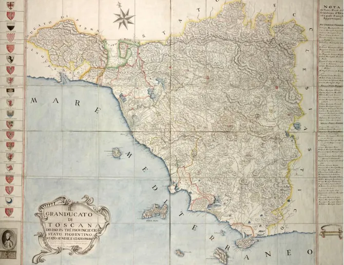
of Tuscany, which was completed in 1830, and printed in Florence in 1831.
Figure 1. The Grand Duchy of Tuscany in a pre-geodetic representation, Francesco Giachi, 1780.
The projection system that was used was by Bonne, already adopted by French cartographers and later also widespread in Italy, because it was considered the most suitable for representations of regions located at an average latitude; the average parallel assumed was the one passing at 43° north latitude and the meridian was the one at 8°30'30 '' east of Paris; for the geographical
2 The Carte de l'Archipel toscan pour servir de modèle topographie, was used, which was made by Dépot de la
Guerre of Paris and the surveyor Louis Puissant at the scale of 1: 50,000 in 1821, based on the well-known triangulation carried out by Napoleonic trigonometrists between the eighteenth and nineteenth centuries, linking Corsica with the Tuscan archipelago and the promontory of Piombino.
[170]
locations and to track the geographical grid, an average value of the Earth's flattening of 1/310 was taken into account. Inghirami was the creator of the local reference system on which the whole operation is based, which originates from a triangulation network built from a base measured in the Pisa region between S. Piero a Grado and Pisa (Rombai, 1993: 159).
The Charter immediately had a large commercial diffusion, qualifying it as a product of great scientific and cultural value, and therefore at a higher level with respect to other contemporary figures at the regional scale, for its precision, for the abundance of data and for the subtlety of this representation (Rombai, 1993: 156-159).
Nevertheless, this representation was not sufficient to meet the multiple needs of the urban and territorial policies of the Lorraine government, engaged in those years in a magnificent modernization project of the Grand Duchy through: reclamation and renovations of marsh areas, building an efficient and widespread road network, modernization and development of agriculture, production and trade activities, etc. Fully aware of this, the same Inghirami, clearly decided to design a topographic map to a larger scale, along the lines of the French one of Cassini. He himself wrote:“La mia carta costruita nella ristretta proporzione dell'uno a duecentomila,
non deve considerarsi che come un oggetto di puro comodo ed ornamento civile: ma se voglia elevarsi al rango di oggetto scientifico, dovrebbe per lo meno ridursi alla proporzione di 1 al ventottomila, corrispondente a quella che il gran Cassini stabilì per la Francia, ed è poi stata adottata presso molti ufizi geografici d’Europa” (Inghirami, 1931: 83).
[171]
Figure 2. The first geometric and geodetic paper of Grand Duchy of Tuscany in scale 1:200,000, Giovanni Inghirami, 1830-1831.
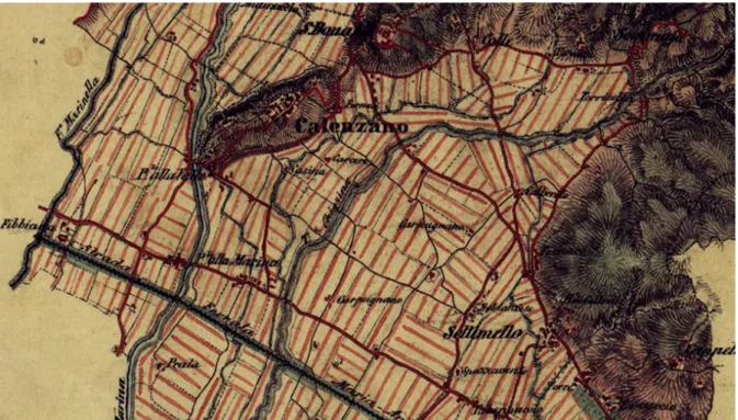
The Lorraine government until after the revolution of 1848, when the l’Uffizio Topografico Militare directed by Celeste Mirandoli, was founded, however, did not welcome this project. The Uffizio brought to completion the Carta topografica del Compartimento Lucchese at scale 1: 28,800, which was launched in 1826 under the Bourbons and then outlined based on a design by Adolfo Zuccagni Orlandini (Rombai, 2013: 134). Subsequently, the survey was extended to the entire central and northern Tuscany, but remained incomplete: in April 1859, when Leopold II had to leave Florence, only 25 sheets were completed.3
3 The sheets cover the territories between Pietrasanta-Pistoia and Florence to the north and Livorno and lower
[172]
Figure 3. One of the sheets of paper in 1: 28,000 scale remained incomplete (particularly in Calenzano Community), 1858.
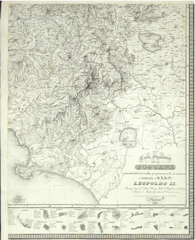
In any case, during the period when the engraving and printing of the Chorography was proceeding to 200,000 and in the years immediately following, Inghirami and his students and collaborators of the Ximenian Observatory proceeded to create the Charter of the Grand Duchy in 1:100,000, which - as recalls the same astronomer and surveyor in 1831, in his speech about the geography of Tuscany held at the Florentine Tuscany Society of Geography, “Statistics and Natural History Patria”, where the product had been “mostly done” - could be reduced into a handy portable atlas of 96 sheets (Inghirami, 1831: 83; Rombai, 1989: 124; Cantile, 2008: 100-104).
Already in 1831, Inghirami was relatively satisfied about the detail achieved with this map. The doubling of the scale, with respect to the printing, with the widespread use of land registry maps and especially of the municipal map frameworks, made “sì che non solo le città e i borghi e in
generale tutti i fabbricati riuniti, possono venir per tal via rappresentati nella loro totalità, ed anche con la configurazione dei loro perimetri, ma di più tutte quante le case isolate campestri potrebbero avervi il loro luogo, senza nocumento alcuno della chiarezza, e con effetto non dispiacente per l'occhio”. Thanks to this content, the author was fully aware that the product
would satisfy the expectations that could have “the statesman, or the swordsman, or the civil engineer, or even the traveller or Geologist” (Rombai, 1989: 124).
Unfortunately, the original was not found again and is considered lost. However, there are two manuscript versions, respectively preserved in Florence at the Military Geographical Institute and at the National Archives in Prague, to help analyze this unique representation and to fully understand the role that this geopolitical instrument had to perform and certainly did perform. Especially in the years immediately preceding the railway revolution, the map clearly highlights the structure of the road system (hierarchically and indicating the roads, for carriages, for vehicles without wheels and for pedestrians), the presence of important structures for the control of commercial traffic and for military control such as: the posts for horses and the taverns, customs, coastal towers and the first installations for the telegraph. It is certain that the representation was
[173]
also designed to accurately portray the continental hydrography and especially the marshes that dotted the Tuscan plains during the years of colossal reclamation work launched by the government of Leopold II (1924-1859).
Even today, the Charter, in the two known versions, is capable of providing an extraordinary documentation to anyone - geographer, historian, architect, urban planner etc. – who studies the area with historical purposes. In particular, it can serve to study landscape-territorial organization of the overall Tuscany of the Grand Duchy, in the '30s and' 40s of the nineteenth century, and even individual topics, such as: settlement, road systems, river basin and local administrative organization and toponymy. In addition, the map is particularly useful for the recognition of these issues in the organization's current geographic Tuscany, including for the preparation of plans for territorial management experienced in the preservation of the landscape and cultural heritage. Not surprisingly, the map preserved in Prague - which will be discussed below - was georeferenced right in the course of the work that led to the drafting of the current Territorial Address Plan having the equivalent effect of the Landscape Plan, approved in 2015 by the Tuscany Region.
The 1:100,000 map preserved in Prague and the comparison with the Florentine map of the Istituto Geografico Militare
The two colour manuscript versions are not directly referable to Giovanni Inghirami, but everything leads one to believe that they are closely derived from the original of the Piarist scientist and designed, separately from one another, between the mid 30s and the beginning of the 40's, by state engineers.4 Obviously, the figures have been updated to represent an area
undergoing rapid transformation, thanks to large public works then in progress, dedicated particularly to hydrography, roads, and to some cities (especially Livorno).
The first version of the Charter, preserved in Florence, IGM - Istituto Geografico Militare,5 first
even chronologically speaking, is produced on glossy paper with the title Carta Geometrica della
Toscana nella proporzione di 1 a 100,000 copiata dall'originale compilato dall'astronomo Padre Giovanni Inghirami anno 1846, and it was thought – erroneously – a copy of the Prague version
described below; also the date (of another hand and then added later) is, according to our study, wrong, since postponed by about 10 years, as we will try to prove on the basis of topographic content.
The second version (preserved in Prague),6 is called Carta geometrica della Toscana nella
proporzione di 1 a 100,000 and consists of 60 sections of 33,7x20 cm each, numbered
consecutively starting from the northwest (Lunigiana), like the version of Florence. Even here the numbering is broken into sections that cover territories outside the Grand Duchy, which is also
4 This is probably the group of technicians of Alessandro Manetti, active in the first cartography office of the
Grand Ducal State, the Imperial and Royal Laboratory, founded in 1828 and producer of countless maps on land reclamation areas.
5 The Charter consists of 92 sheets of 34x21 cm, contained in an envelope along with the map framework and
the cover page with the title and scale, with each sheet properly oriented with north at the top, lying on thick paper and designed with the single planimetry, thus without topographical forms. The villages and roads are drawn in red, the hydrography in blue, borders with foreign states are indicated by a succession of crosses in black and the location names are also written in black; It lacks the internal administrative division in the community and provincial compartments.
[174]
framed in a rectangle divided into 92 sheets.7 The 60 tables actually drawn are complemented by
its the overall printed picture (scale of 20 Tuscan miles = 55 mm, with graduated frame), in two sections, with the title and legend, however, that refer to the printed version of the 200,000; and a table with the precise title, the graphic and metric scale and the legend relative only to the roads.
Figure 4. The Inghirami’s paper in version 1:100,000 preserved in Prague, 1840-1841.
The tables are divided into: postal routes, provincial and royal roads, municipal roads (all represented with two lines or one line), and in provincial roads not for any vehicles but for pedestrians (shown with dashed lines, respectively, with dashes and dots and dashes only). Compared to the IGM Charter, the one in Prague has used colour to represent international boundaries and, in addition, - always with various colours - even the internal administrative boundaries, for the communities are outlined: an innovative content of great interest, that is also missing from the print at 200,000.
The Prague Charter is not dated, however - on the basis of the content represented- can be referred, with a good probability, a few years after the IGM version, namely in the late '30s and early' 40s, with preference for the years 1840-41.
Let's see now the elements that can enable us to date the map IGM to 1835-36: first of all - in the two sheets that frame Florence and its surroundings - the two new iron suspension bridges on the Arno are missing (San Fernando and San Leopoldo), built between 1836 and 1838. What does appears, however, is the new Livorno customs wall together with the first Barrier built, the Florentine one (with the walls that began construction in 1835 and the Barrier built in 1836-37). In addition, there are: the Montebamboli Carbon Fossil Mine in Massa Marittima, explored in 1835-36, with the enthusiasm of the Grand Duke Leopold II, who thought to use it to power the
7 The sheets not numbered go from 4-13, 24-27, 37-39, 48-49, 51, 61-62, 72-74, 77, 83-87, 89 and 93-96, with
[175]
new and large state-owned smelting furnaces of Follonica;8 the Follonica-Strut-Scarlino carriage
road, built in 1836; and the great Casone Franceschi, built at the edges of the Scarlino marshes in 1835-36. The map also features: the fence embankment created by the filling in of the small marshes of Cassarello di Follonica, divided by the larger marsh of Scarlino in 1835-36; and there is only a part of the Grand Canal of Allacciante Macchiascandona-port of the Castiglione della Pescaia channel, which will be finished at the end of the '30s. In contrast to what has been claimed above, it is inexplicable that the Prata-gole road of Boccheggiano-San Galgano-Frosini-Montarrenti is defined as a carriage road, because, from the archival records and the memories of Leopold II, is to be opened to carriage traffic only starting from 1842. The Prague map, however, represents it only for certain traits, which are shown still as pedestrian roads and not carriage roads.
Even other missing items – with respect to the map of Prague - confirm that it was made in the years 1835-36, for example: the hydraulic structures (channels with various functions, embankments and filled enclosures) made for the drainage of the marshes of Piombino Maremma, Scarlino Castiglione della Pescaia from the late '20s; agricultural structures of the grand ducal estate of Alberese (the nondescript building of Vacchereccia appears but not those of the graneries and warehouses, which are instead present in the Prague map, along with the tavern and the farm headquarters); and even those of the Vada and Cecina estates. Finally, there are many roads still referred to as pedestrian (such as Puntone-Castiglione della Pescaia) that were turned into carriage roads, in fact, in the second half of the 30s and beginning of the next decade.
Let us now see the reasons that lead us to date however the Prague version to 1840-41: first of all there are no records on the construction of the first railway between Florence and Pisa-Livorno and not even on the construction of the great dam with an aqueduct and carriage road between Argentario and Orbetello (work begun right in 1841). Among the most significant presences we have: the two Florentine suspension bridges mentioned above and the city of Livorno, which is designed with the entire new customs boundary, with its barriers and doors (Fiorentina, San Leopoldo, Maremma and San Marco) and the Guard Corps; all work undertaken since 1835 and terminated in 1842. Then we find: the Villaggio di Vada, a small planned town built around the ancient tower from the second half of the '30s and the beginning of the next decade; and the
Casone della Cinquantina, the grand ducal estate of Cecina, in the same period. Other structures
present in the Prague map but missing in the IGM map are related precisely to the operations of hydraulic reclamation and agrarian colonization undertaken directly by the Grand Duke or by the large estates, especially in Maremma. For example: the Casone of Franceschi near the marshes of Scarlino; the chapel of San Guido and the straight avenue of Bolgheri; the close-by Casoni of the Gherardesca in the territory between Bibbona and Castagneto; the so-called Venturina in the Campiglia plan, along the new via Emilia-Aurelia; the large groups of buildings of the Alberese farm.
In addition, the Prague map also documents, with assistance from the previous decade, the work done or in progress in the late '30s and early' 40s to the swamps of Piombino, Scarlino and Castiglione della Pescaia. In addition, the map of Prague also shows the wells and other facilities linked to the start (from 1839) of the exploitation of the new lignite mine in Montebamboli Massetano;9 and even a census was taken of the roads rendered for carriages - or at least with
8 Such enthusiasm disappeared in 1839, when the mineral proved to be much poorer lignite, and therefore the
mine was left to the management of private entrepreneurs.
9 Specifically, the map shows: Pozzo I S. Cecilia, Pozzo II Sposa di Pitiot, Pozzo III, P. abbandonato, Gallerie
[176]
ongoing initiatives to make them such - between the late '30s and the beginning of the next decade, like for example the Paganico-Montalcino.
Andrea Cantile had already found that the two versions of the map to 100,000 diverge “by various differences, particularly evident in the toponymy and in the road network.” Actually the differences are numerous and include: municipal boundaries (absent in the IGM version and present in the Prague version);10 the towns; the manner of representation of the wetlands; and also
the decomposition of the Charter in the many numbered sheets of rectangular shape (63 in the IGM version and 60 in the Prague version). The remaining sheets of the map framework - those that do not cover the Luxembourg territory or contain the Tyrrhenian Sea - are not numbered nor, obviously, drawn. In the IGM map, the 63 sheets are reduced to 60 for the loss - longstanding – of numbers 38 (Gorgona Island), 39 (Scoglio della Meloria) and 49 (Capraia Island).11
10 The map also shows the IGM sheets 8, 10, 27, 38-39 and 49 not present in the Prague map, except the last one,
that in the Prague map is numbered 50. Note that in sheet 8 the corner with Piancaldoli customs and Giuncola sul Sillaro is included; in sheet 10 is the tiny corner of Patrignone (today Romagnolo) with the Via dell’Adriatico between Imola and Faenza, microscopic areas, the first contained in sheet 20 and the second absent in Prague map; in sheet 27 the edge with the coastline of the Bocca di Serchio and the Bocca d’Arno that, at least in part, are included in sheet 28.
11 To add that in the volume of Cantile (2008) - without any explanations given about it - the sheets 81
(Pitigliano) and 82 (Sorano) are not published; Furthermore, the comparison with the Prague version shows that the publication is also devoid of the two microscopic Luxembourg territory strips placed on the eastern border with the Papal States, respectively, in the town of Cortona along the Nicone creek and in the territories of Cetona and San Casciano dei Bagni (areas that, in the Prague version, are shown in the sheets 60 and 71).
[177]
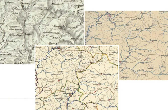
Figure 5. The detail Inghirami’s map 1:100,000 compared with the 1:200,000 version.
Overall, the map of Prague has much richer topographic contents related to populated locations and with the representation of wetlands and, more generally speaking, to placing names of rivers and mountain reliefs. In the latter regard, a quick comparison made on some sheets covering Tuscany sharecropping reveals that the names present in the Prague version are between two and three times that of IGM; for all of the Apennines area and the large Maremma estates, the gap is significantly or greatly reduced, even though the Prague version always records a higher number of names.
In any case it should be noted that the less rich IGM map presents, sometimes in contrast, positive surprises, outlining some items (mostly isolated agricultural settlements lacking names) and also some names of places that are not present in the Prague map. All this confirms the assumption made above: these are two maps entirely independent of each other, made in 5-6 years, and derived both - with countless updates of topographic content – from the original Inghirami document of 1831.
[178]
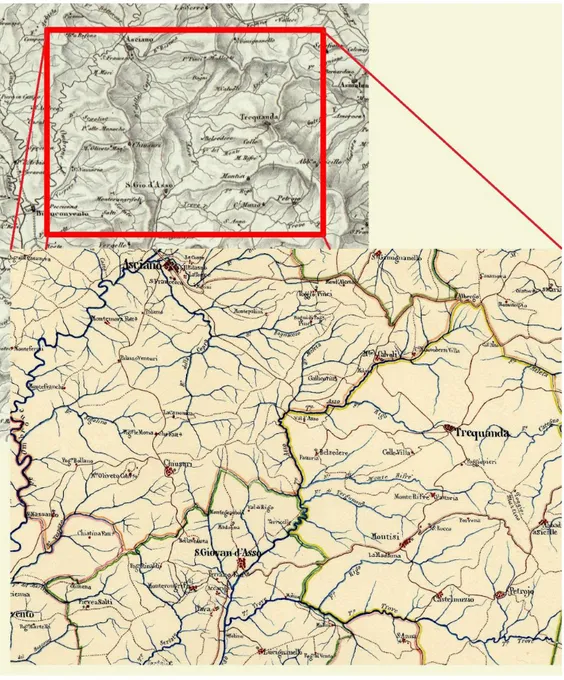
Figure 6. The area of Asciano, Trequanda and San Giovanni d'Asso in the details of the following representations, from top: printed paper at 200,000 (Inghirami, sheet 3), manuscript paper to 100,000 (Military Geographical Institute, sheet 57),
manuscript paper to 100,000 (Prague National Archives, sheet 57).
Georeferencing of the Charter to 100,000 preserved in Prague
The georeferencing of the document to 100,000, stored in Prague, performed on the IGM map of Italy, right in the course of preparation of the Landscape Plan of the Region of Tuscany, has revealed the exceptional nature of the representation considered and the extraordinary application possibilities of geographic data that it preserves; it can thus be the basis for planning and land management.
As already mentioned, this is a completely innovative representation that originates from the first cartographic product of the entire Grand Duchy of Tuscany,12 the general Land Registry,
comparable to contemporary cartography and therefore also suitable to be processed through GIS applications; of course, this applies to all other representations that are derived from the land register, which (as is known), however, present a smaller scale. Our map at 1:100,000 is an “optimal” representation, because it is placed in an interim reduction scale of the detail of the particle geometric land registry (usually 1:2,500/1:5,000 but with municipal map framework up to 1:60,000) and the famous Giovanni Inghirami 1831 printed chart to 1:200,000.
The reference scale of the figure we georeferenced is of considerable importance as it allows you to view directly, and to easily utilize, a lot of data that would otherwise have to be extracted from over 11,000 sheets of cadastral maps that make up the Gran Ducal territory. It is precisely this advantage that has permitted us to use the information on the graph of the road infrastructure to
12 The area covered by the General Land Registry refers to the extension of the Grand Duchy of Tuscany of the
Restoration period. This therefore excludes the territories that were part of the Duchy of Massa, the State of Lucca and also the Tuscan Archipelago that were detected in the 40's.
[179]
support the studies that led to the drafting of the current Tuscan Territorial Address Plan having the equivalent effect of the Landscape Plan of 2015. The result achieved is to be considered extremely satisfactory, even for the geometric properties of the vector data collected.
Figure 7. The georeferencing process in sheet n.31 Inghirami’s Charter.
As we know, the choice of the document to be georeferenced is dictated by some basic requirements, such as: the quality and completeness of the information; the possibility of their “spatialization” and mapping; the significance of the reference period. The Prague chart contains all of these aspects, making it a sort of photograph of the early nineteenth century in Tuscany and possessing all of the geometric properties needed to apply the transformation algorithms. In addition, the conservation status of the document is to be considered excellent, and this particular element is not a factor to be underestimated. In fact, having been designed to be divided into blocks (we could define it today as “travel size”, like the modern road maps, and this document has travelled many roads... first in Tuscany and then to Prague, in the wake of the Grand Duke and his family), it was not a given that it would be found in such good shape: this consideration implies the positive value to minimize the metric errors that may arise from the nature of the cartographic support.13
Regarding the images used and their processing, it is emphasized that the digital format in which we have received the images was that of uncompressed TIFF at 300 dpi; After a first evaluation of the costs / benefits, however, it was decided that all stages of the process would have benefited by
13 If anything, it must be taken into consideration that the scanning of the original was not achieved at a very
high resolution and not with a flatbed scanner; therefore, although the scanned images are still a good resolution, there is an obvious error of a latent background that, however, has not invalidated or altered the good final result of the georeferencing operation.
[180]
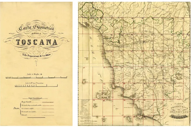
a conversion to JPEG format. Therefore, all 60 tablets that are used (96 of which cover the entire geographical space in the North-South / East-West limits of Tuscany, only 60 are those that contain at least a portion of the regional ground and thus were actually made of paper),14 were
converted to this format, maintaining the original resolution of 300 dpi in both the horizontal as well as the vertical scale, maintaining the depth of 24 bits and the colour representation in the RGB mode to 16.8 million shades.
Subsequently, the cut-out method of the images was compared in order to have an overlap with a transparency effect between the georeferenced cartography and the historical one yet to locate, and also to obtain a satisfactory final mosaicking between the various sheets that make up the whole Charter: so we proceeded, first, to the cutout of the original maps along the edge of the individual sheets; therefore, the maps were georeferenced with the aim of creating a continuous mosaic; and, finally, the digitalization of the various layers of information was made. In conclusion, our paper allows you to identify - in the territorial structure of the landscape-territorial organization today as a whole but also specific themes (settlements, roads, river basin planning, municipal administrative boundaries, toponymy) - the structures that were defined in the long historical period and almost until the national unification, being the document dated to around 1840.
As stated, until now the focus has been directed exclusively to the road network, but we intend to expand the operation to the georeferencing of all of the other territorial content: namely, the hydrographic network, the settlements and the toponymy, that in our chart looks much larger than the 200,000 printed and with respect to other contemporary figures. In addition, perhaps the most important content - as mentioned above - is represented by the municipal boundaries, which do not appear in any of the other maps derived from the Land Registry.
The georeferencing process has taken into consideration two methods to reach the definition of a correct and efficient methodologically process,15 that is, to choose the most appropriate procedure,
from the matching metric point of view, with modern geographic systems and the most advantageous from the timing point of view. Both methods have foreseen ArcGis as a georeference software, but two different approaches to homogenize the original cartographic material were needed.
The digital reproductions of individual maps were, at first, cropped, and combined with a photo-editing software, until reaching an extension similar to cartographic productions with a smaller reference scale; the nature and quality of the reproductions, however, have determined the intrinsic errors, even more “exasperated” in the next spatial positioning. Next, a geo-referencing “ad mappam” was performed, which was more regular and precise: each map, of the 60 that make up the entire territory of the Grand Duchy of Tuscany (in “portrait” format), has been positioned by reference to the cartography IGM 1:100,000 and the maps of the General Union of the Land Registry of Tuscany in the '20s and' 30s of the nineteenth century (which occur at different reference scales, a maximum of 1:50,000-1:60,000).
Despite having taken into account in the georeferencing, different processing algorithms (for each map various control points were “placed”), almost always, the application of a linear
14 In reality, as can be seen in figure XXX, not all of the territory is "covered" by the cartographic work: in fact,
the territory north of the town of Firenzuola, a mountainous area on the border with the Papal States, and almost uninhabited, was not reproduced with an appropriate tablet, but is reproduced only in the map framework of the individual maps.
15 Concerning the issues related to the georeferencing of historical maps in particular we see: Azzari et al., 2002;
[181]
transformation was chosen (with a first degree algorithm), but in some circumstances we also opted for the second-degree polynomial. In recent cases, however, we have found that the extreme deformations of the maps have made their placement in certain points not very precise; therefore, adopting a “sub-cadastral map” positioning has been considered, placing in a satisfactory manner the areas of each single sheet “in pieces”. In doing so, we have obtained a result that approximates with very low metric error (no more than 50 meters), although in the “peripheral” areas some very substantial errors (250-300 meters) result. To further reduce the positioning error, if necessary, the cartography of the General Land Registry of Tuscany (where the maps of the municipal areas were available) was also used, in an attempt to conduct georeferencing through contemporary spatial data.
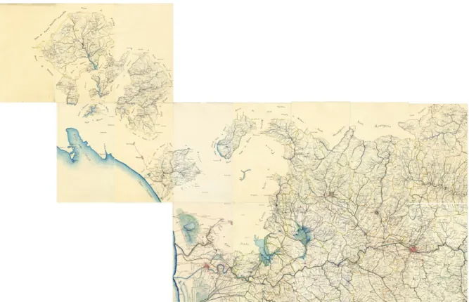
Figure 8. The northwest Tuscany in the georeferenced mosaic of 15 sheets Inghirami’s Charter.
In fact, in addition to the difficulty of positioning due to the technical system of cartographic material preparation, in some cases many deformities were also found in the “forms”, which cannot be derived exclusively from an actual evolutionary change of the territory. In these cases, we can also trace these problems to the digital reproduction of the original product. For example, in map no. 18 there are strong discrepancies in the north eastern part of the map: we are in correspondence with the political boundaries of the Grand Duchy, on the border with the Papal States, but in the Orsigna Creek area there are metric errors that may result in part from a different, more attentive preparation of the map; in part, especially on the right side of the Reno River, the errors may also result from the reproduction in digital format of the representation itself.
In conclusion, such spatial content can then be used not only for historical-territorial and geographical-historical studies, but also for the preparation of plans for experienced territorial management and for the preservation and enhancement of landscape and cultural heritage.
[182]
References
Azzari M., De Silva M., Pizziolo G., 2002. Cartografie del passato e GIS per l’analisi delle trasformazioni del paesaggio, in Beni ambientali e culturali e Geographical Information Systems, Firenze, Firenze University Press.
Baiocchi L., 2002. Georeferenziazione di cartografie storiche in ambiente GIS e loro verifica mediante rilievi GPS, in Atti del VI Convegno Nazionale ASITA, Milano.
Barsanti D., Rombai L., 1986. La guerra delle acque in Toscana. Storia delle bonifiche dai
Medici alla Riforma Agraria, Firenze, Edizioni Medicea.
Campana S., 2003. Catasto Leopoldino e Gis technology: metodologie, limiti e potenzialità, in trame spaziali, in “Quaderni di Geografia Storica del Dipartimento di Storia dell’Università di Siena”, Siena.
Cantile A., 2008. La carta geometrica della Toscana: affrancamento dalla “disonorante indolenza” e primato cartografico europeo, in Andrea Cantile (a cura di), Toscana geometrica. La prima corografia geodetica regionale e il contributo dell'Osservatorio Ximeniano, Firenze, Istituto Geografico Militare, 2008, 85-161; 100-161.
Guarducci A. (a cura di), 2006. Mappe e potere. Pubbliche istituzioni e cartografia nella Toscana moderna e contemporanea (secoli XVI-XIX), “Trame nello spazio. Quaderni di Geografia storica e quantitativa”/2, Laboratorio Informatico di Geografia/Dipartimento di Storia dell’Università degli Studi di Siena. Firenze: All’Insegna del Giglio.
Inghirami G., 1831. Discorso intorno alla geografia della Toscana e illustrazione della carta geometrica della Toscana edita nel 1829, in Antologia, XLII, 69-88.
Rombai L., 1989. P. Giovanni Inghirami, astronomo, geodeta e cartografo. “L’illustrazione geografica della Toscana”, Firenze, Osservatorio Ximeniano.
––––– 1989. Strade e comunicazioni nella Toscana lorenese, in Vie e mezzi di comunicazione nella Toscana dei Lorena, Fiesole, Tip. Comunale, 12-31.
––––– 1993. Imago et descriptio Tusciae. La Toscana nella geo-cartografia dal XV al XIX
secolo, Venezia:, Marsilio.
––––– 2013. Toscana e Italia tra Risorgimento e Unità. Le innovazioni cartografiche del XIX
secolo nelle conservatorie dell'Istituto Geografico Militare, Firenze: Istituto Geografico Militare.
Rumsey D., Williams M., Historical maps in GIS, in “Past time, past place. GIS for history”, a cura di A.K.Knowles, Redlands, ESRI Press, 2002.
Tarchi G., 2003. Quando a San Rossore passeggiavano i cammelli. L’evoluzione del paesaggio in un’area umida costiera, in “Carte al quadrato. Premio GIS-Toscana. Segnali e segni per terra”, Firenze, Regione Toscana.