1
POLITECNICO DI MILANO
Scuola di Ingegneria dell’Informazione
Master of Science in Computer Engineering
A MODEL DRIVEN APPROACH TO THE
DESIGN AND IMPLEMENTATION OF SMART
CITY BASED APPLICATION USING IFML
Supervisor: Prof. Marco Brambilla
Tesina by: Burak Unutmaz
Student ID: 833126
2
Abstract
Nowadays, with the huge jump in technological developments and growth of population in urban areas, the need of connectivity and reaching out to information that is useful and needed gained a huge significance. With this requirement, emergence of the term “smart” started to be used for cities to provide better connectivity and thus better services to increase life-quality. Smart city initiatives, allow governments to identify daily life problems of both citizens and visitors of the city, and gave them a chance to create solutions for those problems with the implementation of smart city ideas in various domains. One of the important domains of smart solutions started to be adopted more and more by the governments and private sector providers is “Smart Tourism”. Undeniable importance to country’s economy and its openness to technological innovations makes tourism a perfect field to apply smart ideas. It aims at creating a unique experience for tourists by applying smart solutions in the domain of tourism and fulfilling the needs of tourists throughout the time they spend in the city. This paper takes advantage of the latest developments and investments on smart tourism ideas and aims to enhance the experience for tourists by applying a model driven approach in that domain with the help of “Interaction Flow Modeling Language”.
3
Table of Contents
Abstract ... 2 List of Figures ... 4 Chapter 1: Introduction ... 6 Chapter 2: Background ... 9Definition of Smart City ... 9
3Cixty Platform ... 10
IFML: Interaction Flow Modeling Language ... 15
Web Ratio ... 18
How the background technologies were used in the application? ... 20
Chapter 3: Related Work ... 21
Chapter 4: Main idea behind the project and use cases ... 25
Use Cases ... 27
1. Finding Events Near to User Location ... 28
2. Finding Events in Specific City ... 34
3. Finding Places Near to User Location ... 36
4. Finding Places in Specific City ... 42
Chapter 5: Implementation Experience ... 44
Domain Model of the Application ... 44
Connection with 3Cixty Platform ... 47
Interaction with the User Interface using IFML and Web Ratio ... 48
Chapter 6: Conclusion and Future Work ... 56
4
List of Figures
Figure 1. Architecture of 3Cixty Platform (https://www.3cixty.com/fr/3cixty/) ... 10
Figure 2. 3Cxity APIs for both mobile and web applications ... 12
Figure 3. 3Cixry Mobile “Nearby Events” API ... 13
Figure 4. Sample 3Cixty API result for “Nearby Events” ... 14
Figure 5. IFML Essentials ... 16
Figure 6. Sample IFML Model Example ... 17
Figure 7. Web Ratio Tool ... 18
Figure 8. Sample example of usage of Web Ratio Components ... 19
Figure 9. Agile Development Cycle ... 19
Figure 10. Extending the components and templates ... 20
Figure 11. Events Near User’s Location Use Case ... 30
Figure 12.Social Login Screen ... 30
Figure 13. Search for Events and Events Near Your Location ... 31
Figure 14.Events configuration options ... 31
Figure 15.Event charts to visualize events in the following week ... 32
Figure 16.Selected Event Date ... 32
Figure 17.List of addresses to set destination point ... 32
Figure 18.Event list based on the set destination ... 33
Figure 19.Google Maps to set destination and bike platforms icons ... 33
Figure 20.Bike Platform information ... 33
Figure 21.Events in Specific city Use Case ... 35
Figure 22.Event city selection ... 35
Figure 23. Event list for specific city ... 35
Figure 24. Page Number and Page Size parameters to modify result item list ... 35
Figure 25.Places Near User's Location Use Case ... 38
Figure 26. Options to retrieve places... 38
Figure 27. Set destination address manually ... 39
Figure 28. Place list ... 39
Figure 29. Google Maps showing place icons around user location ... 40
Figure 30. Info for new events around place icon ... 40
Figure 31. Event icons around place ... 40
Figure 32.Event icon with info provided around places ... 41
Figure 33.Places in Specific city Use Case ... 42
Figure 34. Places list ... 43
Figure 35. Event and Place domain models ... 44
Figure 36. Geolocation and Bike Platform domain model ... 45
Figure 37.Event and Place categories domain model ... 46
Figure 38.User Account domain model ... 46
Figure 39. How to query 3Cixty endpoint with unit inputs ... 47
Figure 40. Sample View Container with View Components inside ... 48
Figure 41. Action Definitions defined in the application ... 49
5
Figure 43.Get Address and Bike Platform Info Action Definition ... 50
Figure 44.Get Events Action Definition ... 50
Figure 45.Get Places Action Definition ... 51
Figure 46.Get Address Action Definition ... 51
Figure 47. Get Events-2 Action Definition ... 51
Figure 48.Get Events-3 Action Definition ... 52
Figure 49.Get Events Categories Action Definition ... 52
Figure 50.Place Categories Action Definition ... 52
Figure 51.Sample Navigation flow with the parameter binding ... 53
Figure 52.Sample Data flow ... 54
6
Chapter 1: Introduction
Each city in the world that has considerable amount of population, or touristic value and attracts lots of people in a year, tries to improve their infrastructure so that it provides better services to its inhabitants and to the people who want to visit the city for touristic purposes in order to make their lives easier. In that sense, the idea of smart city is growing day by day. Smart cities provide better opportunities by utilizing the cutting edge technology in the market in a way that people get the most benefit out of it in their daily lives.
“Cities are the centers of innovation and the people living in them want to be connected. Most cultures around the world are at a point where they cannot live without the Internet.” (J.F. Rossetti, 2015). Besides from the article of “Internet of Things and Smart Cities” by Rosaldo J. F. Rossetti, the idea of creating and investing on smart cities by governments and private sector are at the top of priority lists nowadays due to the fact that cities are not just places anymore where we like to visit or we like to call home but also complex infrastructures that deliver living spaces to more and more people each day with the growth in population and connect those people to each other acting like a living organism waiting to be improved.
With the importance of communication in cities around the world and people want to be connected, smart city ideas are also improving and growing each day. These ideas are crucial for sustainable global growth because they focus on six main sectors for better life quality. Based on the article of “Smart Water: A Key Building Block of the Smart City of the Future” by Leinmiller and O'Mara in WaterWorld Magazine, these six sectors are smart energy, smart integration, smart public services, smart mobility, smart buildings, and smart water. In the light of these information, various projects and solutions have been proposed already to solve the most significant problems of cities such as traffic management in the sense of congestion and road safety by Cisco and AGT, smart parking systems, smart water systems by Schneider Electric which is working on more than 200 smart city projects according to Leinmiller and O'Mara in WaterWorld Magazine and many more are on the way to deliver high-quality life standards. As of now, this utopic idea of having a “smart” city will become more realistic and vital for our lives even more than we thought of.
As mentioned above, governments and private sector are leaning towards and giving more importance to idea of implementing smart city not only to provide better life opportunities to their residents, but also try to make the cities more attractive to those who have an equal
7
value as much as inhabitants of the city called tourists. Rightfully so, they have a great value in the eyes of governments and private sector because they bring considerable amount of income to the country’s economy each year, and they promote the city in a way that more people will be attracted and interested in visiting. The importance of touristic value of a city has been one of the top priorities for governments throughout years.
Being a stranger in a city and not knowing the opportunities that it provides to you while you are visiting that city is something that should be addressed, especially in tourism. So, it is crucial to address these issues that may prevent tourists from discovering cities in an efficient way. If you have ever visited a city, you know that one of first things to do is to check where to visit, or look for possibly intriguing events, and discover ways of transportation so that you can travel the city without having too much trouble. Imagine that, you want to visit a place or attend an event you have been tracking for months. First, it is required to know the location, then if it is a place, you need to check for working hours. If it is an event, then you need to know in which time period that event is active. If you are lucky enough to learn these information in a short period of time and everything is done, you have to find a way to reach that point of interest. As you can see, it seems like a small task, but it includes many little subtasks inside of it, and it becomes hard to achieve especially for those who are a stranger to the city or unless they have a guide.
Having all of those provided to you is almost impossible without thinking about the idea of smart city because it requires to integrate different information collected from various sources. There are some guides recommended for tourists to follow in order to achieve those tasks but they are not provided in a compact way and are not as efficient as having all in one. In this era, with the fast development of Internet, the information is shared and used for integration. Bringing and more importantly integrating all these information together and providing a “smart” solution should be the task to be accomplished.
As a result of these requirements, a platform called 3Cixty were built in order to live up to expectations in the area of tourism and cultural integration by entrepreneurial education organization called EIT Digital. It is a platform that gives you instant access to the cities’ most desired information. It is also an efficient solution and provides tools to create web and mobile apps in the sense that it allows those apps to use its knowledge base and therefore it’s rich APIs. With the use of 3Cixty platform, it is possible to retrieve, compare and integrate information about various events, places, and transportation options in a city. Developing and implementing feature-rich, tailor-made apps for the need of specific user targets is possible in an efficient
8
way. 3Cixty platform also allows to plan trips and prioritize specific points of interest based on the choices that users make. Therefore, it is a useful platform for achieving smart city ideas in the context of tourism and cultural information.
By using the knowledge-base of 3Cixty platform, it is aimed to help citizens and tourists to be aware of the opportunities and help them to know about the important aspects of the city mainly by finding events and places. To explain briefly about the project, as mentioned before, the app utilizes valuable information coming from 3Cixty APIs, integrating those with event and place information, provides guidance to the users throughout the city in a safer way with paths to follow along with the suggestion of transportation options.
The rest of the paper is structured as follows:
Relevant Technologies used at the background: An explanation of background technologies used and how they affected the project.
Related work: Brief explanation of related researches or similar types of projects in the same domain.
Main idea of the project: The theoretical idea behind the project and the detailed explanation of use cases.
Implementation Experience: The architecture behind the system that is implemented with the help of IFML and Web Ratio and implementation with the explanation of each feature provided.
Conclusion: Short summary of work done, possible future work to extend the project and limitations.
9
Chapter 2: Background
Definition of Smart City
The term smartness is an indication of intelligence however being a smart means more user-friendly compare to being an intelligent (Nam and Pardo 2011), and this smartness can be achieved with the aid of technology in the concept of “smart city”. When we use the term “smart” for a city, what we want to tell is how well connected and integrated the city is with the technology, i.e. the more integration provides the city with the technological enhancements, the smarter it gets. Besides, the city gets smart in order to serve well to its residents as much as it could.
Moreover, not only the integration with the technology, but also providing high quality life, being self-sustainable, and investments done by the government to enhance the infrastructure categorize the city as “smart” (Caragliu et al. 2009). The citizens also acknowledge the benefits and consequences of living in a smart city. Thus, being connected to the resources that city provides, and utilizing them efficiently are one of the important choices that they make (Bakıcı et al. 2013). Development and tracking the progress of smart cities are well analyzed in the tool called “Smart City Wheel” by Boyd Cohen and he divides these indications of smartness into the six main items (Cohen (2012)).
1) Smart Governance: which indicates the public involvement and openness of data through the governance mechanisms.
2) Smart Environment: which is related with the efficient use of energy and therefore creation a sustainable management of available resources.
3) Smart Mobility: which explains the reachability to modernized transportation systems and connectivity inside and outside of the city.
4) Smart Economy: which suggests to shape or modify the economic strategies around technological developments.
5) Smart People: which sets the standard for the sufficiency and quality of citizens 6) Smart Living: which simply includes the quality of life in terms of tourist attraction,
healthy environment etc. (Baudouin 2012).
Therefore, combining and implementing all those attributes with the human behavior and development helps to increase the number of smart cities around the world.
10
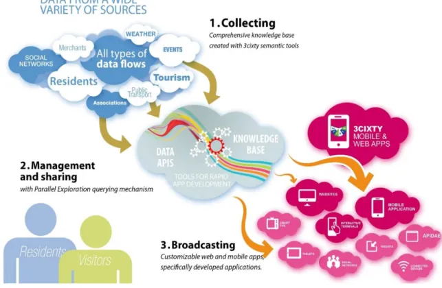
3Cixty Platform
With the huge gain in popularity and importance of smart city projects, the resources that are available and capabilities that they accomplish are growing incrementally day by day. One of the latest examples of this projects is 3Cixty Platform. It is a platform that aims to help combining tourism and mobility with the information provided by its knowledge-base.
Specifically it provides information about events, places and transportation options to visitors, citizens, tourists and event participants. The main feature of the platform is the knowledge-base that have been integrated for the cities such as Milan, or that are under construction such as Nice and London. It integrates all kinds of data from various resources to use. With this huge amount of information, it allows developers to create their own apps and customize them however they like. Since it allows reuse of its knowledge-base for different type of apps, it is divided to two main categories as mobile and web applications. The APIs for each categories are different and provide rich features in terms of usability. The following figure shows you the architecture of 3Cixty Platform (Figure 1).
11
The features of 3Cixty platform can be explained like the following:
Rapidly create a knowledge base: enables the creation of a city knowledge base, in which heterogeneous data from various sources are integrated and semantics of the data is made explicit.
Querying the knowledge base: provides access to the knowledge base via easy to use REST API.
Parallel Exploration of events and places: an easy to use Graphical User Interface to search and combine information about a city such as events and places.
Query Augmentation Service: enables users to augment queries automatically based on data provided by others (e.g., reviews by friends or users).
A “Wish List” Service: allowing users to create a wish list of events and places.
A Mobility Profiling service: enables tracking user movements within the city, including their use of modes of transportation.
Generic Crowdsourcing Platform: enables users to contribute real-time information to the platform to help others (crowdsourcing).
A Social Network Mining Service: enables users to know what people are talking about in the city on social media.
Rapid app development environment: provides developers with support to quickly develop 3cixty apps.
As mentioned above, the platform provides APIs that are REST and are easy to use. In the next figure, the APIs are listed based on two categories namely for the mobile and for the standard (web) application usages (Figure 2).
12
Figure 2. 3Cxity APIs for both mobile and web applications
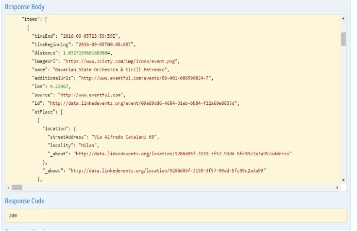
As it can be clearly seen from the figure, the APIs are listed to find events and places around a specific city. Some examples of the provided APIs are finding events and places near to given location, finding events/places in a city, finding events/places with a given category in a city etc. The platform also gives an opportunity to test the APIs on this website (Figure 3). Simply developer needs to enter required parameters of which the explanation to each parameter is given, and can query the result right away from the website. Also the model schema which shows how the result will look like in each supported format is integrated to the website
13
so that developer will understand what to expect. The result body will show the query result from the knowledge-base and gives developers an opportunity to explore items to be used in the apps (Figure 4).
14
15
IFML: Interaction Flow Modeling Language
It is a modeling language based on controlling user interaction, expressing the content for the front-end software applications. Following domains are described by the IFML’s user interaction and control behavior:
HTML+HTTP based Web applications.
Rich Internet Applications, as supported by the HTML 5 standard. Mobile applications.
Client-server applications. Desktop applications.
Embedded Human Machine Interfaces for control applications. Multichannel and context-aware applications.
Covered aspects of IFML can be described as follows: Provides multiple views for the same application It can be used for mobile and multi-device applications Visualization of data and production of events are possible
Components are independent of concrete widgets and presentation.
Interaction (Navigation and Data) can be triggered by the user or external events User input validation and constraints
IFML is designed and inspired from the WebML and Web Ratio. “It has been adopted as a standard by OMG in March 2013. In February 2014, OMG issued the Beta2 version of the standard, which is candidate to become the official IFML 1.0.” (Marco Brambilla 2015). It supports platform independent descriptions of graphical user interfaces for the applications deployed on desktop, laptop computers, mobile phones etc. Some essentials of IFML are like the following (Figure 5):
16
Figure 5. IFML Essentials
Based on that figure, there are seven elements that describe the IFML behavior. These are namely;
Container: An interface element that includes other elements such as View Components, events, actions etc. For example, window in desktop applications or page templates in web applications
View Component: Displays content or accepts input and can be associated with events. For instance, HTML list, an input form etc.
Event: Represents the user interaction with the application or triggered by the system. For instance selecting an item from the list, submitting inputs from a form etc.
Action: Can be triggered by an event and change the state of the user interface. For example, inserting an item to a database.
Navigation Flow: Describes the input-output dependency. The output of source has some association with the input of the target. For example, sending parameters in HTPP requests.
Data Flow: Allows to pass data between view components or actions.
Parameter Binding Group: Set of parameter bindings associated to either navigation flow or data flow.
17
A small example of IFML with essential elements is like the following (Figure 6)
18
Web Ratio
Web Ratio is open and extensible platform and is an eclipse-based IDE which shares the same workspace as all the tools and extensions already available in Eclipse for developing J2EE applications (Figure 7). The tool utilizes the intensive use of IFML standard to define the interaction flow between the user and the application with the help of IFML elements (Figure 8). It combines the simplicity with the power of expression. It also provides quick and agile development cycles (Figure 9) and 100% code generation of standard JEE applications. It adds/extends generation rules such as defining new components and presentation styles (Figure 10). It also supports fully model driven development. Web Ratio allows developers to design prototype-based web and mobile apps thanks to IFML, and saves times since it removes the need for mockups.
19
Figure 8. Sample example of usage of Web Ratio Components
20
Figure 10. Extending the components and templates
How the background technologies were used in the application?
First of all, a model driven approach was decided to use due to its efficiency, decoupling that makes it possible to separates presentation from the business logic, easy to use structure and other benefits that puts forward this approach into other methodologies. Secondly, as a modeling language, IFML was chosen due to its success and being relatively more efficient, more modern language and due to reasons that were explained in IFML section. Also, as a tool to combine all of them, Web Ratio was used. There are two different versions of Web Ratio namely for Web and for Mobile development. In this paper, the application was aimed to be developed and function as a web application. However, in a technical sense, thanks to model driven approach and specifically IFML for making it possible, easier and efficient to utilize same visualization and structure (with the same type of elements) among other platforms, developing the mobile version of the application is just a matter of changing the business logic from Java to JavaScript since the front-end part will not change. And finally, as the knowledge base and the heart of the application, 3Cixty platform was utilized in different use cases that will be explained in later sections.
21
Chapter 3: Related Work
In this section, similar types of researches with the project conducted around the same domain will be explained. Each paper either discusses the theoretical approach to the subject and highlights the benefits or the necessity of applying smart tourism ideas or puts forward an implementation of an idea.
A paper from La Rocca, R.A. 2013, discusses the undeniable contribution of tourism to the economy of countries and explains how the cities should take actions to meet the demands of tourists. She highlights the fact that in order to make the cities more attractive and dynamic to changes, keeping up with the technological developments, governments and companies from private sector started to lean towards smart tourism ideas to get ahead of other cities because based on the research done in Italy, tourism makes a contribution of 130 billion euros to the national gross product and indicates that it is the main investment field among others also for the political campaigns and strategies. Because of this irresistible effect of tourism, she believes that cities need to provide better structures and services in order to compensate the deficiency that can happen from the growth of technological enhancements and people started to utilize those more and more in their daily lives. According to her study, the so called “experiential component” that represent latest evolutions in the domain of tourism adds value to the supply system in order to make the experience unique for the tourists. So trying out new and innovative approaches generates positive results on tourist experience. In the light of these seamless experiences, she states that the transition from traditional approach to “smart destination” has already begun. Also the interest towards this new approach is adopted by the tourists and market operators easily due to the fact that it changes the way tourists use cities and their resources and brings huge gains to the market operators. Therefore, the idea of smart tourism not only enhances the way how the governments use city resources, but also opens new opportunities and gives visitors to be part of this unique experience.
Another paper from Gretzel, U. et.al 2015, explains the reasons of why one cannot avoid using the term “smart” also in tourism just like in any other field. According to them, tourism is a phenomenon that brings social, cultural and economic factors together and causes people to move from their usual environment to somewhere that they are not used to breathe for different reasons. They divided the term “smart tourism” into multiple components and layers. The first component from the their system is defined as “Smart Destination” which are special
22
use cases applied to the cities in the domain of tourism to improve the quality and service infrastructure in urban areas both for its citizens and tourists. They gave the example of Barcelona with a reference to Lopez de Avila (2015, n.p.) saying that the city of Barcelona offers its visitors smart bus terminals that provides features such as touristic info, bus arrival times, and USB ports for charging their smartphones. Also bicycle sharing platforms all around the city gives visitors a chance to experience environmental friendly way of transportation and they can check their location all the time via smartphone app. Another component is called “Smart Experience” which focuses more on the personalization of technological improvements in the area and tries to create context-awareness and real-time monitoring (Buhalis and Amaranggana 2015). This component foresees tourists to be active most of the time, and create and enhance the data that is the core of the experience. The final component is “Smart Business” which describes the creation of complex business ecosystems that enables to exchange touristic resources. It encourages public and private collaboration as a result of governments being more open to technological changes and give more emphasis to apply those changes to certain areas as they are the main suppliers of infrastructure and data being used. Those three components are built along with three layers to compliment and complete the architecture they describe. The three layers are “Smart Information” which describes the collection of data, “Smart Exchange” that encourages and supports interconnectivity, and “Smart Processing” which controls the visualization, integration, analysis and smart way of using data. They believe that the smart tourism with the above definition, will provide huge benefits to tourism and accelerate the initiation of new era with the smart cities sits on top of Internet of Things. They also discuss the idea of changing the business models for tourism firms since with the implementation of smart tourism, new opportunities and market areas will be available for them. With the possible huge jump of smart tourism in the next couple of years, the amount of data needed will be exponentially high, so the trust factor between the user and providers occupies a big space. That is why they also want to gather attentions along with all the benefits on smart tourism being harmful and dangerous since it can create privacy issues if it is not used with a care.
By giving the similar importance to the emerge of smart tourism, Kaur, K., Kaur, R. 2016 draw the attention on why smart city and smart tourism should be a priority. Various technologies and services play a role on the creation and popularity of smart tourism such as web, mobile, cloud computing, Internet of Things (IoT), Big Data analysis etc. With the huge potential on such services in terms of collecting data, they claim that in order to build a smart
23
living in general, all the complimentary services makes the living possible such as education, health-care, tourism etc. should be smart as well. They exemplified a use case of Taiwan’s “In-Joy-Life Smart Tourism” with a reference to (Chih-Kung Lee et.al) as a government’s initiative of attracting people and make efficient usage of resources for both citizens and tourists especially during the peak seasons. Virtual tours are organized via their smartphones and touch screens at different locations. Based on the reference to (Gretzel et. al), they explain the idea of creating a smart tourism ecosystem from tourism suppliers to tourism consumers, or to other services such as telecom operators banks and raise the attention on how well they collaborate to each other because the interaction between those parts bring all together the smart tourism, and helps making it efficient and useful. They also shares the same concerns about privacy and keeping the data inside the domain of tourism issues just like Gretzel, U. 2015, and considering the amount of data shared among these services, they also agree on the topic that in order to handle such a huge infrastructure change, business models should be revolutionized.
A good example of an implementation for smart tourism is explained in the paper of Cacho, A. et.al 2015 in the case of 2014 FIFA World Cup in Brazil. According to statistics taken from FIFA in the paper, World Cup (WC) had a record attendance with 3.4 million tickets allocated, and around 1 million tourists arrived from 202 various countries. In order to use the opportunity, an initiative called “Find Natal” was created with the collaboration of city of Natal in Brazil to create smart tourism destination. With this project, it was going to be clear to understand how the city of Natal transformed itself into a smart destination by adopting the technological changes. Natal hosted around 173.000 tourists during the WC. Based on the above facts, it was decided to focus on the smart tourism destination initiative as a first step of defining a smart city. Therefore, considering the increase in the number of smartphone usage, it was decided to create an application called “Find Natal" to improve the quality of travel experience. The app simply collects data from smartphone about user trajectories around the city and generates a heat map showing all the points with density. This map clearly shows the parts of Natal which were interested by the tourists during WC and this information is very valuable to tourism firms to know more about tourists’ behavior. The application also gives additional information such as the duration of each visit, timing of each visit, number of visits to the location etc. It can also show trajectory outliers to understand the unexpected behaviors and their reasons. Therefore, with the “Find Natal” project, a real-time smart tourism idea brought to life in order to enrich touristic experience.
24
Another example of implementation on the domain of smart tourism is given by Harshita et.al 2015. They pointed out the fact that with the help of smart tourism concept, tourists will be able to reach information without any time and place restrictions. In that sense, a mobile application was designed and created to help tourists on searching information and get a result instantly. The system provides the result via text, pictures or other guidance information. It is composed of Google Maps API, image search mechanism through the camera of their smartphones, and calculation of the distance between two different locations. When users encounter any unknown item or place, they simply need to point out their camera and take a photo of that object, place, a landmark, a QR code etc. to search it on Google. Then, Google returns results about the object, and users can calculate the distance between this objects location and their initial location that was defined in the system based on latitude and longitude information. If they want, they can upload their location to their favorite spot in the database. The location will be added and becomes a new touristic place for others.
25
Chapter 4: Main idea behind the project and use cases
After giving an introduction and explaining the technologies at the background, in this section, it is time to propose a solution in a more detailed way. The problem statement as indicated in the introduction of this paper, is to lack of a smart city solution and application in the domain of tourism and cultural integration. With the growing population of cities around the world, and huge development of the Internet in recent years, people started to be connected or at least want to be connected most of their daily lives in order to get more benefits from the living and active world. In that sense, this is the reason why smart city initiatives and projects made a huge jump and got more popularity among governments and private sector companies. ‘‘Smart’’ is often used in the terms to indicate the intelligence, self-sustainability, autonomy and connectivity of an object or a system, as in smart phone or smart card (Gretzel, U. et. Al 2015). So, with the increase of smartness in the number of items that we use every day, people who are citizens or being in a city for different reasons started to acknowledge the importance of having such objects, using such systems or in general living in a smarter city. The term smart city represents a place or an environment where the city is a living organism together with the technology and provides opportunities to its inhabitants (Buhalis, D., Amaranggana, A. 2014). Smart city solutions have been applied and are being applied to different domains. One of the most significant domains among the others is the tourism or “smart tourism” as how we call it these days. It is a crucial subject to be addressed in order to make the city more attractive and it also aims at increasing the quality of city infrastructure as these intelligent tourism systems be more and more autonomous and self-sustainable each day. “The development of Smart City also facilitates seamless access to value-added services both for its citizens and tourists as city visitors” (Buhalis, D., Amaranggana, A. 2014). So, the idea of “smart tourism” or intelligent tourism occupies a vital place in the plans of government agencies. Obviously, these systems should be thought through and built with a lot of care. Because “an intelligent tourism system is built on trust, scalability, and openness with respect to participants and services” (Gretzel, U. et. al 2015).
26
In the light of these information, a collaboration with the 3Cixty platform was made to provide easy to use, user-friendly smart tourism ideas and the project was designed in a way that people will be connected all the time in this interactive and dynamic environment. The aim was mainly to design and develop an application for the people who are usually visitors, tourists and have an intention to utilize smart city solutions. Thanks to the dynamic structure of the project, people will be aware of the latest activities around the city and begin to discover them without losing any time. The idea provides access to 3Cxity platform and its APIs to discover and participate different points of interest around the city. With this project, it was aimed to improve the touristic values of cities and to contribute tourism and as a result of that helping to develop economy. Even if it might not be a huge contribution, it strengthens the governments’ hands in a way that they have a great chance to keep up with the changing and dynamic world and encourage other smart city solutions in the same domain.
The project focuses on two main points of interests. One of them is to discover and participate events happening around the city within the indicated time period. In a city, throughout the year, lot of events are happening. It is quite an important factor to know what kind of events are there in a city for the visitors and tourists because they will realize how dynamic the city is and have a chance to participate them with the citizens. So, the cultural integration will be achieved and people will have opportunities to demonstrate their cultural inheritance to the ones who would like to learn. Another point of interest is to present places that might be interesting to visit or have a memory. In every city, as all of us know, there are cultural and touristic well-known places that are suggested to visitors to visit. If you are visiting a city that has lots of cultural or authentic places, then you probably do not want to miss any of them especially if you have limited time to be around. Knowing the exact location, information about the place and how to reach to that location, ways of transportation to use, and the distance from where you are to the place is often tiresome to learn. In order to shorten that time and give all the necessary information in a compact way to the person whenever he/she needs it, a feature to discover places was included and aimed to solve the highlighted issue above.
Speaking of the transportation, especially in Europe, the places are very near to each other, and as a tourist you might not want to get involved into city traffic because it might steal some time from your daily plan. So, as a safe, time-saving and environmental friendly way, the application offers a way of transportation as showing all the bike stations around the city with the useful information attached to them.
27
Use Cases
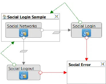
In the project, there are four main uses cases. These are related with both discovering events and places as indicated in the previous sections. As an initial unit, social login was implemented to protect user data, and provide secure access. Users can access to the application using one of their social accounts. Currently, the social accounts that are supported by the application are Google+, Facebook, and Twitter.
For the events, there are two use cases present in the application to provide the easiest way to the user to learn about the events happening around the city. First use case aims at finding the events near user’s current location. This use case, as it can be understood from its name highlights events near to user’s current point with a previously decided range. The default range from the user’s current location to the events is 2.5 km. So, within that indicated range, all of the events will be shown to the user with other useful information that will be explained in detail. Second use case is to find all the events around the specific city. Currently, Milan is fully supported by the 3Cxity platform with all the information needed. The city of Nice and London are under construction to fully support the same features as in Milan. So, there might be some missing information currently in the platform about some attributes of events found, however, they will be completed and provided in the future. This use case simply shows events around the city without having any distance range set by the application.
Similarly, for the places there are two use cases just like in the events. The first one helps users to find intriguing places near to user’s current location inside the predefined range with other useful information. The second use case helps finding places around the city without having any restrictions.
There are also two more APIs developed in the project, but were not utilized as use cases. For the initial implementation, above use cases were found enough and sufficient. These two additional units may be used as a future work in the later implementations. They simply help to find specific events and places based on the category indicated by the user. So, for example, if the user wants to find a place in the category of “hotel” or “food”, the application is capable of retrieving those places only, and visualize the other necessary information. Similarly, for the events, if the user wants to see or attend events in the certain category, it is possible to show the details of these type of events by the application.
28
Therefore, in the next subsection, each main use case mentioned above will be explained in detail to understand the capabilities and the features that the application provides.
1. Finding Events Near to User Location
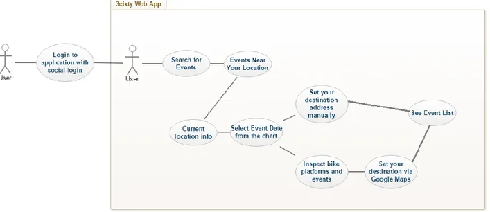
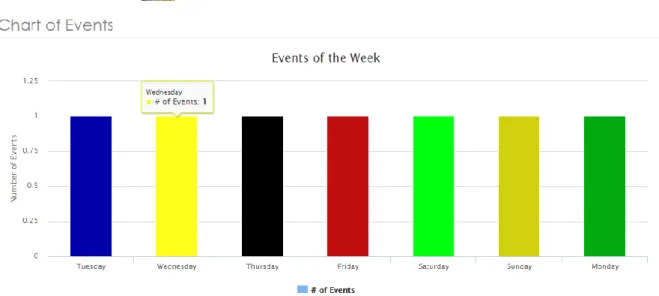
Detailed Description of Use Case: This use case (Figure 11) aims to find events near to user’s current location. First, users are asked to login the application by one of their social accounts (Figure 12). Then with the selection of “Search for Events” and “Events Near Your Location” options (Figure13) they will be asked to enter their current address to locate them on the map (Figure 14). Once the users indicate their address, the application searches through the 3Cixty knowledge-base and finds event that will happen in the next week. It will visualize all the events in the following week in a chart for better understanding (Figure 15). So, in this way, users can see in a weekly period how many events will occur. The application expects user to select a date in the chart, and proceed with the next page (Figure 16). In the next page, users have two options. In the first option, it was assumed that users might know the address of the destination you want to go to. So, the application offers users to enter the explicit address info. Then, in the next page, they can select the address information they provided (Figure 17) and immediately see the list of events happening in the selected day and 2.5 km around that address (Figure 18). The reason for showing the list of address they provided in the previous section is to show other alternative addresses with the same name but with different coordinates around the city if there is any. With this way, selection of a wrong address is avoided. In the final page, users can inspect the events along with the other information such as the distance of each event from the current user’s location, category of events, starting and ending date of events with the time information, and links to additional info page about events. Second option to find the destination is by using Google Maps feature. Once the users enter the current address information, a marker showing the same location will appear on the map along with the bike stations around that location (Figure 19). The bike station icons will appear within the range of 500 meters to that same address. The users can click on the bike station icons to see dynamic info provided by the app such as available bikes, number of empty slots etc. (Figure 20). Along with the bike station icons, event icons showing the exact location of the events happening on selected day will appear within the range of 2.5 km. The
29
users, if they want to, select a destination point and look for event details by clicking “Get Event Details” link. This link directs user to the same result list with the first option. As a side note, the number of result items and result page return from the knowledge-base can be modified through the development tool which is Web Ratio. Primary Role: User. The application allows users to select date in the following week only.
Pre-Conditions: - The users should be logged in to the application
- The users should enter a current address to the application - The users should select a possible event date to proceed
- For the first option to get events, the users should set a destination address to reach to the event list
Triggering Condition: After log-in, the users should select “Events Near Your Location” option.
Main tasks: - Social login: Allows users to log-in to the application - Retrieve events based on the selected date
- Visualize number of events based on each day in the following week
- Display Google Maps with user current location, bike platforms around that address within the range of 500 meters and with events within the range of 2.5 km.
- Retrieve destination address from the user - Show list of events with additional information
30
Figure 11. Events Near User’s Location Use Case
31
Figure 13. Search for Events and Events Near Your Location
32
Figure 15.Event charts to visualize events in the following week
Figure 16.Selected Event Date
33
Figure 18.Event list based on the set destination
Figure 19.Google Maps to set destination and bike platforms icons
34
2. Finding Events in Specific City
Detailed Description of Use Case: This use case (Figure 21) aims to find events around a specific city. The cities supported by the application are Milan, Nice and London (Figure 22). Once the user selects a city, the complete event list that is retrieved from the knowledge-base will be shown to the user (Figure 23). Since there is no date selection in this use case, the listed events are retrieved based on current day and beyond. So, users might also see the events that will occur days/months from the current day. The reason for that is to give a chance to users to plan their trip accordingly since there is no chart here to show events in the following week. As a side note, the number of result items and result page return from the knowledge-base can be modified through the development tool which is Web Ratio (Figure 24). In the event list, users will be able to see similar information to the first use case about each event.
Primary Role: User. The application offers only three city options to choose from.
Pre-Conditions: - The users should be logged in to the application - The users should select a city to list the events
Triggering Condition: After log-in, the users should select “Events in Specific City” option.
Main Tasks: - Social login: Allows users to log-in to the application - Retrieve events based on the selected city
- Show events starting from the current date and beyond - Show list of events with additional information
35
Figure 21.Events in Specific city Use Case
Figure 22.Event city selection
Figure 23. Event list for specific city
36
3. Finding Places Near to User Location
Detailed Description of Use Case: This use case (Figure 25) aims to find places near to users’ current location. After a successful login, users need to select “Search for Places” option to proceed with the use cases related to finding places around the cities. Similar to use cases with events, users will have two options to look for places namely, “Places Near Your Location” and “Places in Specific city” (Figure 26). After the selection of first option and entering the current address information, users do not have to set a specific date as in the events case, and will be directed to page where they can set their destination. In this page, there are two options just like in the event use cases. First option is to set destination point by entering the address information (Figure 27). After the selecting the address in the next page, they will be directed to the page where they can see list of places (Figure 28) with useful information such as name and address of the place, the distance from the users’ location, the category in which the place belongs to, telephone number of the place, additional info as link etc. As a second option, users can see the places around their location with the related icons attached to each place (Figure 29). Again, just like in the event use case, the user marker will be placed on the map with the initial coordinates. Around that marker, places within the range of 2.5 km will be located and shown to the users. Similarly, in order to provide a way of transportation, bike platforms are also placed within the range of 500 meters from users’ location. The bike platforms will provide useful information when the user will click to them. Apart from the event use case, when the place icons are clicked, users will get an info (Figure 30) about events near to that place icon within the range of 1km. And they will appear on the map (Figure 31). The events are retrieved based on the date of current day and beyond due to inform users about upcoming events. Besides from having event icons on the map, users can interact with them to see related information about each event (Figure 32). When the user clicks to each event near to that place icon, it will provide info such as event name, the starting and ending date of each event and a link to a web page where users can find additional info about the event. With this way, dynamic structure of application was preserved and integration of events and places was achieved. So, users will not miss any upcoming or current events around the city. Finally, the users, if they want to, select a destination point on the map and look for place details at the new point by clicking “Get Place Details” link besides from the
37
places shown on the map. This link directs user to the same result list with the first option. As a side note, the number of result items and result page return from the knowledge-base can be modified through the development tool which is Web Ratio.
Primary Role: User. The application does not restrict user in anyway. Pre-Conditions: - The users should be logged in to the application
- The users should enter a current address to the application - For the first option to get places, the users should set a destination
address to reach to the place list
Triggering Condition: After log-in, the users should select “Places Near Your Location” option.
Main tasks: - Social login: Allows users to log-in to the application - Retrieve places from the knowledge-base
- Retrieve events based on the current date and beyond. Also the event icons will appear based on the distance between event and place icon clicked
- Display Google Maps with user current location, bike platforms around that address within the range of 500 meters and with places within the range of 2.5 km.
- Retrieve destination address from the user - Show list of places with additional information
38
Figure 25.Places Near User's Location Use Case
39
Figure 27. Set destination address manually
40
Figure 29. Google Maps showing place icons around user location
Figure 30. Info for new events around place icon
41
42
4. Finding Places in Specific City
Detailed Description of Use Case: This use case (Figure 33) aims to find places around a specific city. The cities supported by the application are Milan, Nice and London. Once the user selects a city, the complete place list that is retrieved from the knowledge-base will be shown to the user (Figure 34). As a side note, the number of result items and result page return from the knowledge-base can be modified through the development tool which is Web Ratio In the place list, users will be able to see similar information to the first use case about each place.
Primary Role: User. The application offers only three city options to choose from.
Pre-Conditions: - The users should be logged in to the application - The users should select a city to list the places
Triggering Condition: After log-in, the users should select “Places in Specific City” option.
Main Tasks: - Social login: Allows users to log-in to the application - Retrieve places based on the selected city
- Show list of places with additional information
43
44
Chapter 5: Implementation Experience
Domain Model of the Application
After explaining the theoretic idea behind the project with the reasons and describe the four main use cases in detail that bring the project together as a single unit, it is now time to discuss the core architecture behind those use cases and understand how things work, i.e. how the domain model was designed, how was the interaction with the 3Cixty platform, the creation of custom units that were used in the application with the Web Ratio tools etc. will be topics of this section.
To begin with, it is needed to talk about the domain model objects and how data that is seen in the interface was designed. Since the application utilizes events and places heavily in its use cases, it is clear that event and place objects should be created first. Both objects were designed based on the information that is going to be visualized in the interface. What this means is that, both the event and place objects include properties that carry useful information for the users such as event name, event starting and ending date or place address, distance of both the events and place objects to the users’ location etc. In the following figure, both objects can be clearly seen and these are the core objects to be built on (Figure 35).
45
Secondly, there are two other important objects in the application that are not functioning on the foreground as the events and places objects, but they are as significant as those. These two objects are called geolocation and bike platform objects. Geolocation object is utilized to find the address information of a given location, therefore it includes properties to return address related parameters such as latitude and longitude, or the open address of the location as a string, e.g. Via Castelnuovo 7, 22100. Bike platform object, as it can be understood from its name, decides what type of information will be carried and shown to the user about each bike station around the city. Both those objects and their properties can be seen in the following figure (Figure 36).
As mentioned in the use case section, there are two other components that were designed but not used in the application which are called “event categories” and “place categories”. These objects are very similar to events and places in terms of attributes that they include because they basically return same type of information with them. For example, event categories returns events only in the category that is indicated by the user. So, even though they are not utilized in the project, they can be included in the later versions of the application. Similarly, the objects and their related properties can be seen from the following figure (Figure 37)
46
As a last object used in the domain model, application holds user account model in order to manage social login feature (Figure 38). This object simply holds properties such as the username, id, and access token etc. It is very similar to regular user account object that might be used in login pages.
With this last object the domain model objects are fully covered. Next, it is required to talk about the connection between the application and 3Cixty Platform and how the custom components were created.
Figure 37.Event and Place categories domain model
47
Connection with 3Cixty Platform
Custom units are the heart and soul of this application, and Web Ratio as a tool, allows developers to create custom operations (units) to manage specific business logics. The tool also uses Java programming language as the main language in the web platform to create those custom units besides from IFML in the front-end. In that sense, creating a connection between the application and 3Cixty platform is as easy as creating a connection with other services in Java thanks to utilization of REST APIs in the platform. Each domain object that was described above are used in custom units, and these units helped completing use cases in the application. Necessary inputs of the each component are gathered with the help of java beans and the each unit queries the related 3Cixty endpoints with those inputs as the endpoint parameters (Figure 39). Therefore results that are retrieved from the 3Cixty platform using the APIs were put it into bean components and the outputs of each component were generated. These bean components are then stored in the domain objects with the help of “create” unit that was defined in the Web Ratio tool.
48
Interaction with the User Interface using IFML and Web Ratio
Interaction among user interface components are done thanks to IFML and Web Ratio tool. As mentioned in the IFML section, there are seven main elements used to describe IFML. The first of those elements is “View Container” which was used as pages in the web application. This element simply contains all other “View Components” inside a single page such as forms, social login units, lists, messages etc. These pages serve for different purposes such as login, retrieving address information, get events/places etc. with the help of “View Components” (Figure 40).
Moreover, when the users land a single page, there are “Events” waiting for them to interact. These events trigger “Actions” to perform a task. Each action is defined by the so called “Action Definition”. The list of “Action Definitions” can be seen from the following figures (Figure 41) with the internals of each “Action Definition” attached to them. These “Action Definitions” are used to perform use cases in the application with the aid of “Custom Units” or “Custom Components”. Each unit serves different purposes such as retrieving events/places or retrieving the user’s address etc. and these units were created in Java as business logic of the application to work with the front-end.
49
Figure 42.Get Bike Platform Info Action Definition Figure 41. Action Definitions defined in the application
50
Figure 43.Get Address and Bike Platform Info Action Definition
51
Figure 45.Get Places Action Definition
Figure 46.Get Address Action Definition
52
Figure 48.Get Events-3 Action Definition
Figure 49.Get Events Categories Action Definition
53
The other important element to connect those “View components” to each other and enables data exchange or direct the flow of the application is called “Interaction Flows”. Interaction flows can be in two types namely, “Navigation Flows” to be used to navigate the user from page to page while carrying data (Figure 51), and “Data Flows” to be used to carry data only from one component to another which is called “parameter binding” in the Web Ratio terminology (Figure 52). Each “Data Flow” was utilized to receive or send data from or to “Custom Units” or to other “View Components” such as forms.
Therefore, with the given information, the interaction covering the uses cases are shown in the following figures with the whole interaction model of the application at the end (Figure 53).
54
55
56
Chapter 6: Conclusion and Future Work
Smart city initiatives and projects in the domain of tourism increases and improves day by day. With the growing amount of investments made by governments and private sector companies, tourism will become smarter in the sense that it will become our new life standard. Moreover these developments in the area will lead us towards a future where everyone will be connected to anywhere around the world and cities will become even smarter not only in the domain of tourism but also in various different domains.
Smart city solutions create great obstacles for the providers who are willing to try new approaches because of necessity to have complex infrastructures and huge network structures that encapsulates the whole city. However, thanks to revolutionary enhancements in the in Internet of Things field, a huge breakthrough will happen and we will see more creative projects in terms of resource usage that gives us unique experiences.
With this project, it was aimed to encourage other initiatives such as this one and with the great support of 3cixty Platform, IFML, and Web Ratio tool, it became possible to create such a diverse application. The domain model was designed and generated based on the use cases and these covered use cases in the project were carefully thought through in the way that it will be as much beneficial as possible to guide visitors who want to quickly access information and be connected to it all the time. Giving the opportunity to discover events and places updated periodically around the city with an eco-friendly transportation option allows users to understand the benefits and need of smart city/tourism solutions. Also, this project was designed to be built upon, i.e. new features or integration with different services will be possible in the future to extend its capabilities even more thanks to platform independent modeling feature of IFML.
Currently, the biggest limitation of the project is to have limited amount of cities that are supported because the complexity of building a smart solution requires to use the resources of cities. Once the efficient usage of resources is achieved with the governments understanding and investing more on smart city/tourism initiatives, this project and many others will reach out to more people and the impact area will become larger. Moreover, considering the amount of data processed each and every day, privacy and trust issues might rise up, however it is the job of providers to establish this mutual trust and make sure that these solutions will only be used for the people and not against them.
57
We live in a world that is responsive and dynamic. In order to keep up with the changes, and increase our life-quality, it is required to give enough emphasis to the subjects that make our lives easier. Therefore, utmost importance should be given and necessary investments should be made to live in a smarter and well connected world, especially in this era.
58
Bibliography
[1] - n.d. EIT Digital - http://www.eitdigital.eu/conference/exhibition/3cixty/ [2] - n.d. IFML: The Interaction Flow Modeling Language. http://www.ifml.org/.
2015. "Interaction Flow Modeling Language Version 1.0." http://www.omg.org/spec/IFML/1.0/PDF/.
[3] - n.d. 3Cixty - https://www.3cixty.com/smart-city/ , https://www.3cixty.com/fr/3cixty/ [4] - n.d. Smau - http://www.smau.it/milano14/success_stories/3cixty-una-piattaforma-di-app-e-servizi-per-unofferta-turistica-e-culturale-integrata/
[5] - n.d. WebRatio - https://www.webratio.com/site/content/en/why-webratio
[6] – Bakıcı, T., Almirall, E., Wareham, J., 2013 – Smart City Initiative: The Case of Barcelona, Journal of the Knowledge Economy, Volume 4, Issue 2, 135-148
[7] - Baudouin, P. (2012, October 2). Smart cities. Retrieved September 6, 2013, from Digiworld:
http://blog.idate.fr/smart-cities/
[8] - Buhalis, D., Amaranggana, A., 2014 - Information and Communication Technologies in Tourism
[9] – Cacho, A., Esterague, D., Figueredo, M., et. al, 2014 - A Smart Destination Initiative: the Case of a 2014: FIFA World Cup Host City
[10] - Caragliu, A., Del Bo, C., Nijkamp, P. 2009 – Smart Cities in Europe
[11] – Cisco, 2014 - AGT and Cisco Traffic Incident Management Solution: Improving Traffic Safety and Efficiency
[12] - Cohen, B. (2012). Smart cities hub. Retrieved July 22, 2013, from
http://smartcitieshub.com/2012/11/11/smart-cities-ranking-methodology/
[13] - Gretzel, U., Wethner, H., Koo, C., Lamsfus, C., 2015 - Computers in Human Behavior 50 (2015) 558–563
[14]- Gretzel, U., Sigana, M., Xiang, Z., Koo, C., 2015 - Smart Tourism: Foundations and Developments, Electron Markets (2015) 25:179–188
59
[15] – Harshitha, Ashwitha, Manisha, Vaishnavi, 2015 – Smart Tourist Guide, International Journal
of Innovative Research in Computer and Communication Engineering, Volume 3, Special Issue 7
[16] – Kaur, K., Kaur, R., 2016 - Internet of Things to promote Tourism: An insight into Smart
Tourism, International Journal of Recent Trends in Engineering & Research, Volume 2, Issue 4
[17] - La Rocca, R.A., 2013 - Tourism and City. Reflections about tourist dimension of smart city, TeMA Journal of Land Use Mobility and Environment 2 (201-213)
[18] - Marco Brambilla, Piero Fraternali, 2015 - Interaction Flow Modeling Language Model-Driven UI Engineering of Web and Mobile Apps with IFML,
http://www.slideshare.net/mbrambil/ifml-interaction-flow-modeling-language-tutorial-ui-ux-modeling-design-icwe-2014-object-management-group-by-marco-brambilla
[19] – Nam, T., Pardo, T.A., 2011 - Conceptualizing Smart City with Dimensions of Technology, People, and Institutions
[20] - O’Mara M., Leinmiller M., Smart Water: A Key Building Block of the Smart City of the Future, WaterWorld Volume 29, Issue 12
[21] - Rosaldo J. F. Rossetti, 2015 – Internet of Things (IoT) and Smart Cities, [IEEE Xplore] Readings on Smart Cities – [Editorial] Volume 1, Issue 7, August