TUSCIA UNIVERSITY OF VITERBO
-ITALY-
DEPARTMENT OF TECHNOLOGY, ENGINEERING AND
ENVIRONMENT AND FOREST SCIENCES (DAF)
PHD IN SCIENCES AND TECHNOLOGIES FOR THE FOREST
AND ENVIRONMENTAL MANAGEMENT- XXII CYCLE
SCIENTIFIC SECTOR- DISCIPLINARY AGR/10
RURAL CONSTRUCTION AND FORESTRY LAND
PhD Thesis
Presented by
Aziz Abouabdillah
HYDROLOGICAL MODELING IN A DATA-POOR
MEDITERRANEAN CATCHMENT (MERGUELLIL, TUNISIA).
ASSESSING SCENARIOS OF LAND MANAGEMENT AND
CLIMATE CHANGE.
Coordinator Supervisors
Prof. Gianluca Piovesan Dr. Antonio Lo Porto
Prof. Nicoletta Ripa
2006-2009
This thesis is submitted in fulfillment of the requirements for the Degree
of Doctor of Philosophy.
UNIVERSITÀ DEGLI STUDI DELLA TUSCIA
-VITERBO-
DIPARTIMENTO DI TECNOLOGIE, INGENERIA E SCIENZE
DELL‘AMBIENTE E DELLE FORESTE
CORSO DI DOTTORATO DI RICERCA IN SCIENZE E
TECNOLOGIE PER LA GESTIONE FORESTALE ED
AMBIENTALE-XXII CICLO
SETTORE SCIENTIFICO-DISCIPLINARE AGR/10
COSTRUZIONE RURALI E TERRITORIO AGROFORESTALE
Tesi di Dottorato di Ricerca
Dottorando
Aziz Abouabdillah
HYDROLOGICAL MODELING IN A DATA-POOR
MEDITERRANEAN CATCHMENT (MERGUELLIL, TUNISIA).
ASSESSING SCENARIOS OF LAND MANAGEMENT AND
CLIMATE CHANGE.
Cordinatore Tutors
Prof. Gianluca Piovesan Dr. Antonio Lo Porto
Prof. Nicoletta Ripa
i
ACKNOWLEDGEMENTS
I am greatly indebted to the Water Research Institute (CNR-IRSA) for their financial support
through a grant from the European project “Aquastress”
I would like to express my profound gratitude to Dr. Antonio Lo Porto for his invaluable
contribution through supervision of this PhD research. He had a Paramount input into this research through his guidance from initial proposition to its completion and brought out the best
of me. Thank you.
There is a person I need to mentioned especially, Dr. Anna Maria De Girolamo, I owe her my
sincere gratitude for her kindness, her useful contributions and support at various stages of this work.
Thanks also go to Prof. Nicoletta Ripa for her supervision, help and assistance particularly
during my stay in Viterbo.
To those in the Water Research Institute (IRSA-Bari), I would like to thank with all my heart for
making my study so memorable and pleasurable. Thanks also to the Tuscia University of Viterbo (Italy) for the opportunity provided to me to achieve this academic goal.
I’d like to convey my heartfelt thanks to Dr. Jeff Arnold, Dr. Mike white and Professor Raghavan
Srinivasan for their efforts and assistance, during my PhD training in the Texas A & M University and the ARS-USDA in Temple.
I wish also to thank Prof. Wesley Wess Wallender for his scientific support, as well as his kind
help and assistance during my PhD training in the University of California Davis.
I wish to express my sincere gratitude to the INAT (Institute National Agronomique de Tunis),
and in particular to Prof. Lili Zohra Chaabana and Mr. Aymen Lazrek for their significance help and data providing; the IRD (Institut de Recherche et de Development) in particular Dr.
Christian Leduc as well as to all other data providers not explicitly mentioned above.
I would like to express my most sincere gratitude to Prof. Ahmen Bamouh and Prof, Benasser
Alaoui from my home Institute (IAV-Hassan II) for their significant help and encouragement.
Thanks also to the examiners who provided valuable feedback, Prof. Roberto Mercurio, Prof.
Enrico Marchi, and Prof. Carmelo Riccardo Fichera.
I would also like to express my sincere thanks to the numerous colleagues who have supported
ii
DEDICATION
This thesis is dedicated toMy Father who has raised me to be the person I am today. You have been with me every step of the
way, through good times and bad. Thank you for all the unconditional love, guidance, and support that you have always given me, and helping me to succeed. Thank you for everything. I love you.
My mother, who has been a source of inspiration to me throughout my life. Thanks for your support
encouragement, and constant love that have sustained me throughout my life. I love you.
My sister Chadia, for her never ending moral support and prayers. Thanks for your love and
encouragement, I give my deepest expression of love and appreciation for the encouragement to you and your husband Si'Mohammed.
My brother Moulay Ahmed, thanks for your advices and support. I m very proud of your success. I
wish to express my sincere gratitude to you and your wife Zineb.
My sister Siham, who proffered me unconditional love and support. Thanks to be my friend and my
confidant, you have been a great source of inspiration and motivation throughout the years. Thanks Sima.
My lovely nephews Ali, Omar, Mehdi and Ghali. The happiness of the family. Thanks for giving me
your love and support, and most importantly were often the source of much loved distraction.
The Memory of my dear grandmother who passed away during the first months of this thesis. May
God bless you Oumi.
Ons, for always being here for me. Thank you for your continual love, support, and patience. I could
not have made it through without you by my side.
Loving thanks to my childhood friends Charif, Hatim, Younes, Noureddine and Mehdi who
knowingly and unknowingly- led me to an understanding of some of the more subtle challenges to our ability to thrive important roles.
My friends, Yassine, Soufinae, Otman, Meryem,Houda,Taha, Mounia, Hamid, Hind, Youssef,
Radhouan, Nadia, Farachichou, Moez, Khaoula. They played such important roles along the journey, as we mutually engaged in making sense of the various challenges we faced and in providing encouragement to each other at those times when it seemed impossible to continue. Thanks
for always being there for me.
My most sincere appreciation goes to all my friends, at IRSA, without whom these three years would
have been insufferable. I especially want to show my gratitude to Rita, Manola, Ramona, Gerardina, Daria, Delia, Valeria, Emanuele, Giuseppe, Domenico, Lorenzo, Carlo, Angelo and Vito. You have
all made it a memorable time of my life.
Yours sincerely
iii
ABSTRACT
Title: Hydrological modeling in a data-poor Mediterranean catchment (Merguellil, Tunisia). Assessing scenarios of land management and climate change.
In the Mediterranean regions, hydrologic processes are quite specific due to the temporal variability of precipitation characterized by a succession of drought and flash-flood periods. These processes may also have changed due to a range of human activities such as land use changes, dams building, soil and water conservations works. The Merguellil catchment (Central Tunisia) is a typical Mediterranean semi-arid basin which suffers regular water shortage aggravated by current drought. It extends on an area of about 1200 km² upstream of the El Houareb dam which presents its outlet. This semi-arid zone is exposed to a high variability of rainfall in time and space. Annual means vary between 300 mm in the plain and 500 mm in the highest parts. During the recent decades the continuous construction of small and large dams and Soil and Water Conservation Works (SWCW) (ie. Counter ridges) has taken place within the watershed. These practices, that currently cover nearly ¼ of the basin surface, are classified in two categories: the practices on basin slopes constituted essentially by contour ridges (200 Km²) and the practices on the hydrographical network by implantation of small hilly dams draining about 170 Km. These water harvesting systems may intercept runoff at the upstream part of the catchment, thus depriving potential downstream users of their share of the resources. However, little is known about the effect of these water harvesting systems on the water balance components of arid watersheds.
In such a vulnerable situation of water resources availability, it can be expected that the impact of climate change will further worsen the situation.
The work presented here attempts to simulate the actual water and nutrient balance using the
integrated hydrological model ―Soil and Water Assessment Tool‖ (SWAT 2005). The simulation
results revealed that evapotranspiration is the major component of the hydrological balance. Hydrological Calibration (1992-1994) and validation (1998) have been carried out referring to daily flow data at the Hafouz and Skhira flow-gauges. The model performance was satisfactory and the Nash-Sutcliffe Efficiency coefficient ranges from 0.6 to 0.7.
The model was rather successful in reproducing water flow. However the low sampling frequency and the lack of detailed water quality measurement data did not allow an in-depth
iv
evaluation of the SWAT performance in predicting nutrient and sediment. Some scenarios were further generated. The first one regards the removal of contour ridges to assess their impact to water and sediment load. The results show that the contour ridges contribute to the retention of high quantity of sediment. These regulations reduce the surface runoff by 32 %. Planting the olive trees between contours could improve its yield. The second scenario consists in the reduction of the applied fertilizers. By reducing 20% in the applied fertilizers no change was detected in the olive yield, while a small change was noted for durum wheat yield‘s (-2%). Whereas a net decrease in nutrient load was observed at the outlet. This reduction ranges, from 3 to 10% for nitrates, from 2.5 to 8% for total nitrogen and from 13 to 16.5 % for total phosphorus.
Finally, the SWAT model was used to study the impact of future climate on water resources of this Mediterranean catchment. Future climate scenarios for periods of 2010-2039 and 2070-2099 were generated from the Canadian Global Coupled model (CGCM 3.1) for scenarios A1B, B1, and A2. These CGCMs data were then statistically downscaled to generate future possible local meteorological data of precipitation and temperature in the study area. SWAT model was run first under current climate (1986-2005) and then for the future climate period to analyze the potential impact of climate change on flow, evapotranspiration, and soil moisture across this catchment. Finally, Richter et al.‘s Indicators of Hydrologic Alteration (IHA) were used to analyze the flow regime alterations under changing climate. The main results indicate that this catchment would suffer a combination of increased temperature and reduced rainfall that will reduce water resources in this area. Consequently, summer droughts would be intensified. Different spatial responses to climate change were observed in the catchment for near future simulations. Higher altitude regions would experience an increase of the total water yield, while a reduction is foreseen for lower parts. For far future, a noticeable decrease would affect water resources in all part of the catchment.
v
RIASSUNTO
Titolo: Applicazione di un modello idrologico ad un bacino Mediterraneo (Merguellil, Tunisia) in condizione di scarsezza di dati. Valutazione degli scenari connessi all‘uso del suolo e ai
cambiamenti climatici.
Nelle regioni del Mediterraneo, i processi idrologici sono caratterizzati dalla variabilità temporale delle precipitazioni che si manifesta attraverso la successione di periodi di siccità e allagamenti.
L‘alterazione dei processi idrologici nell‘area del Mediterraneo è attribuibile, oltre che alle alterazioni climatiche globali, anche alla pressione antropica sul territorio attraverso la modificazione dell‘uso del suolo, la costruzione di sbarramenti fluviali e le opere di protezione idraulica e del suolo.
Il bacino idrografico di Merguellil (nella Tunisia centrale) è un tipico bacino semi arido del Mediterraneo caratterizzato da un deficit idrico aggravato dagli attuali eventi siccitosi. L‘area è contraddistinta da un‘elevata variabilità delle precipitazioni nello spazio e nel tempo. In particolare, la media annuale di precipitazione varia tra 300 mm nelle aree di pianura e 500 mm in quelle più alte. Nel corso degli ultimi decenni il bacino è stato interessato dalla costruzione di dighe e le opere di protezione idraulica e del suolo. Queste pratiche, che attualmente ricoprono il 25% della superficie del bacino, si distinguono in due categorie di interventi: quelle che interessano i versanti del bacino, essenzialmente fossi di guardia e terrazzamenti (200 km2), e quelle che insistono sul reticolo idrografico attraverso la costruzione di sbarramenti (170 km). Questi sistemi di raccolta dell‘acqua intercettano il ruscellamento superficiale della parte più elevata del bacino, privando la parte bassa di una cospicua aliquota d‘acqua. Tuttavia, l‘effetto di questi interventi di sistemazione idraulica sulle componenti del bilancio idrico dei bacino aridi è poco conosciuto.
In tale situazione di vulnerabilità delle risorse idriche, ci si attende che l‘impatto dei cambiamenti climatici peggiori la situazione. Il presente lavoro ha lo scopo di modellare le risorse idriche attuali e il bilancio dei nutrienti nel bacino di Merguellil utilizzando il modello idrologico integrato ―Soil and Water Assessment Tool‖ (SWAT, 2005). I risultati delle simulazioni rivelano che l‘evapotraspirazione è la principale componente del bilancio idrologico.
vi
La calibrazione idrologica (1992-1994) e la validazione (1998) è stata condotta riferendosi ai dati giornalieri di portata delle stazioni idrolometriche di Hafouz e Skhira.
La performance del modello è stata soddisfacente ottenendo un coefficiente di efficienza di Nash-Sutcliffe che varia tra 0.6 e 0.7. Il modello ha riprodotto correttamente le portate. Tuttavia la bassa frequenza di campionamento e la carenza di misure dettagliate di qualità dell‘acqua non hanno permesso di valutare approfonditamente le performance di SWAT nel simulare il carico di nutrienti e sedimenti.
Sono stati generati alcuni scenari. Il primo scenario riguarda la rimozione dei fossi di guardi per valutare il loro impatto sul carico idraulico e dei sedimenti. Queste regolazioni riducono il ruscellamento superficiale del 32%. La piantumazione di alberi di ulivo tra i fossi di guardia potrebbe migliorare la resa.. Il secondo scenario consiste nella riduzione dei fertilizzanti utilizzati. Attraverso la riduzione del 20% del quantitativo dei fertilizzanti nessun cambiamento della resa degli ulivi è stato osservato, mentre un ridotto cambiamento è stato osservato nella resa del grano duro (-2%). Invece una netta diminuzione nel carico di nutrienti è stata osservata all‘uscita. Questa riduzione varia dal 3% al 10% per i nitrati, dal 2.5% all‘8% per l‘azoto e dal 13% al 16.5% per il fosforo totale.
Infine, il modello SWAT è stato utilizzato per lo studio di impatto del clima futuro sulle risorse idriche del bacino idrografico. Gli scenari climatici futuri per il periodo 2010-2039 e 2070-2099 sono stati generati dal modello accoppiato globale canadese CGCM 3.1 per gli scenari di emissione A1B, B1, e A2. I dati del modello climatico CGCM sono stati sottoposti ad una procedura di downscaling statistico per generare scenari locali di precipitazione e temperatura dell‘area di studio. Il modello SWAT è stato fatto girare prima in condizioni climatiche attuali (1986-2005) e poi in condizioni di cambiamento climatico futuro per analizzare l‘impatto potenziale dei cambiamenti climatici sulla portata, evapotraspirazione ed umidità del suolo del bacino in esame. Infine, per analizzare le alterazioni del regime di portata sono stati utilizzati gli indicatori dell‘alterazione idrologica (Indicators of Hydrologic Alteration –IHA) di Richter et al. I risultati principali indicano che nel bacino studiato, l‘azione combinata dell‘ incremento di temperatura e riduzione della precipitazione, porterà alla riduzione delle risorse idriche. Gli effetti del cambiamento climatico sulle risorse idriche del bacino non sono univoci per tutta l‘area, ma si differenziano in base alle caratteristiche topologiche del territorio. Le regioni ad
vii
alte altitudine subiscono un incremento del tasso totale d‘acqua, mentre per le parti basse si prospetta una riduzione. Per l‘ultimo trentennio del secolo, invece una pesante diminuzione delle risorse idriche influenzerà tutte le parti del bacino.
viii
RESUMÉ
Titre: Modélisation hydrologique au niveau d‘un bassin versant Méditerranéen (Merguellil, Tunisie) pauvre en données. Evaluation des scenarios de gestion des terres et du changement
climatique
Dans les régions méditerranéennes les processus hydrologiques sont assez particuliers à cause de la variabilité temporaire des précipitations qui sont caractérisées par une succession de périodes sèches et humides. Ces processus sont aussi susceptibles à des changements de type anthropique à l‘exemple du changement de l‘occupation du sol, de la construction des barrages et des travaux de conservation des eaux et des sols. Le bassin versant de Merguellil (Tunisie centrale) est un bassin Méditerranéen, semi-aride qui souffre fréquemment de la rareté de la ressource eau aggravé par les sécheresses actuelles. Au niveau du barrage El Houareb, il draine une aire de 1200 km². Comme tous les milieux méditerranéens et semi-arides, le bassin de Merguellil est caractérisé par une très forte variabilité spatiale et temporelle des précipitations. Les moyennes annuelles varient entre 300 mm sur les plaines et 500 mm sur sa partie amont relativement montagneuse. Au cours des dernières décennies, le bassin du Merguellil a été l'objet de nombreux aménagements hydro-agricoles tel que la construction des petits et grands barrages collinaires, et les travaux de conservation des eaux et des sols (CES) (ex. Banquettes). Ces aménagements, qui s‘étendent actuellement sur ¼ de la surface du bassin, peuvent être classifiés en deux catégories. La première concerne les aménagements des versants par la construction des banquettes. Ces derniers couvrent une surface de 200 Km². La deuxième consiste à la construction des petits barrages collinaires sur le réseau hydrographique. La surface drainée par ces derniers est estimée à 170 Km2. Ces aménagements qui interceptent le ruissellement à l‘amont du bassin, privent par conséquent les usagers à l‘aval de partager la ressource en eau. Par ailleurs, l‘impact de ces systèmes de collecte d‘eau sur les composantes du bilan hydrologique dans les bassins versant arides est encore peu étudié. D‘autre part, dans ce cadre où les ressources en eau sont très vulnérables, il a été prédit que les changements climatiques vont aggraver de plus la situation. Le travail présenté ici tend à simuler le bilan hydrique et des nutriments en utilisant un model hydrologique intégré ―Soil and Water Assessment Tool‖
(SWAT 2005). Les résultats de simulation montrent que l‘evapotranspiration est une composante majeure du bilan hydrologique. La calibration (1992-1994) et la validation (1998) du modèle
ix
sont effectuées en utilisant les séries journalières de débit au niveau des stations hydrométriques de Hafouz et Skhira. La performance du modèle est satisfaisante et le coefficient d‘efficience de Nash- Sutcliffe varie entre 0.6 et 0.7. Le modèle était assez réussi dans la simulation de l‘écoulement. Par contre, la faible fréquence échantillonnage et le manque de mesures détaillées de qualité de l‘eau n‘a pas permis une évaluation plus profonde de la performance du modèle SWAT dans la simulation des nutriments et des sédiments. Quelques scénarios d‘aménagement ont été aussi générés. Le premier concerne l‘enlèvement des banquettes pour évaluer leur impact sur les écoulements et les sédiments arrivants à l‘exutoire. Les résultats montrent que les banquettes contribuent à la rétention d‘une grande quantité de sédiment et à la réduction du ruissèlement de 32%. Par ailleurs la plantation des oliviers dans l‘espace entre-banquettes pourrait augmenter le rendement. Le deuxième scénario consiste en la réduction des fertilisants de 20%. Le résultat de ce scénario montre qu‘il n‘y a pas eu de changement dans le rendement de l‘olive alors qu‘une faible diminution (-2%) a été notée dans le rendement du blé dur. L‘impact le plus net de la réduction des fertilisants consiste dans la diminution de la concentration des nutriments à l‘exutoire. Cette diminution varie entre 3 et 10% pour les nitrates, entre 2.5 et 8% pour le nitrogène total et entre 13 et 16.5% pour le phosphore total.
Finalement, le modèle SWAT a été utilisé pour étudier l‘impact du changement climatique sur les ressources en eau au niveau de ce bassin Méditerranéen. Les futures scénarios climatiques pour la période 2010-2039 et 2070-2099 ont été générés à partir du model ‗Canadian Global
Coupled model (CGCM 3.1)‘ pour les scénarios A1B, B1, and A2.
Ces dernières données dérivées à partir des CGCM ont subis par la suite une réduction statistique d‘échelle en utilisant la technique de ‗statistical downscalling‘ pour prédire à la fin les variables météorologiques de température et de précipitation à l‘échelle locale de la zone d‘étude. Pour analyser les éventuels impacts du changement climatique sur l‘écoulement, l‘évapotranspiration et l‘humidité du sol, le modèle SWAT a été appliqué en deux temps : le premier considérant le climat actuel (1986-2005) et le second considérant le futur climat. Finalement, les indicateurs d‘altération hydrologique de Richter et al. (IHA) ont été calculé pour les deux périodes (actuelle et future) pour évaluer l‘altération du régime hydrologique causé par le changement climatique. Il a été noté que dans le futur le bassin sera sujet d‘une augmentation de température et diminution de précipitation qui vont réduire les ressources en eaux. Par conséquent les sécheresses estivales seront intensifiées. D‘autre part une nette différence spatiale a été observée
x
quand à l‘impact du changement climatique sur le bassin versant et ce pour le proche future. En effet durant cette période les régions à haute altitude pourraient subir une augmentation des ressources en eau alors qu‘au contraire une diminution a été prédite au niveau de plaines. Pour le loin future, une nette diminution des ressources en eau affecterait toutes les régions du bassin versant.
xi
TABLE OF CONTENTS
ACKNOWLEDGEMENTS ... i DEDICATION ... ii ABSTRACT ... iii RIASSUNTO ... v RESUMÉ ... viii TABLE OF CONTENTS ... xiLIST OF FIGURES ... xvi
LIST OF TABLES ... xix
LIST OF PHOTOS ... xx
LIST OF APPENDICES ... xx
ABBREVIATIONS AND ACRONYMS ... xxi
LIST OF SYMBOLS ... xxiii
CHAPTER 1. INTRODUCTION ... 1
1.1 PROBLEM STATEMENT ... 1
1.2 PROJECT HOLDER ... 3
1.3 RESEARCH OBJECTIVES ... 4
1.4 SCHEMATIC PRESENTATION OF THE THESIS ... 4
CHAPTER 2. LITERATURE REVIEW ... 7
2.1 MEDITERRANEAN CONTEXT ... 7
2.2 WATER RESOURCES IN THE MEDITERRANEAN: MAJOR PROBLEM FACETS . 11 2.3 WATER RESOURCES IN TUNISIA ... 13
2.3.1 RAINFALL AND SURFACE WATER POTENTIAL ... 13
2.3.2 GROUNDWATER POTENTIAL ... 14
2.3.3 TOTAL WATER RESOURCES POTENTIAL ... 15
2.3.4 WATER BALANCE ... 15
2.4 HYDROLOGY OVERVIEW ... 16
2.4.1 THE HYDROLOGIC CYCLE ... 16
2.4.1.1 RESERVOIRS ... 18
xii
2.4.1.2.1 PRECIPITATION ... 18
2.4.1.2.2 EVAPOTRANSPIRATION ... 19
2.4.1.2.3 RUNOFF ... 19
2.4.1.2.4 GROUNDWATER ... 21
2.4.2 THE WATER BALANCE: GLOBAL TO CATCHMENT SCALE ... 21
2.5 HYDROLOGIC MODELING ... 22
2.5.1 RAINFALL-RUNOFF MODELING ... 23
2.5.1.1 METRIC MODELS ... 24
2.5.1.2 CONCEPTUAL MODELS ... 25
2.5.1.3 PHYSICS-BASED MODELING ... 26
2.5.2 LOCAL MODELING PROCEDURES ... 27
2.5.2.1 MODEL STRUCTURE SELECTION ... 28
2.5.2.2 SENSITIVITY ANALYSIS ... 28
2.5.2.3 CALIBRATION ... 29
2.5.2.4 VALIDATION ... 33
2.5.2.5 PREDICTION - INCLUDING UNCERTAINTY ... 34
2.6 HYDROLOGICAL PROCESSES IN ARID AREAS ... 35
2.6.1 DATA SCARCITY IN ARID AND SEMI ARID AREAS ... 35
2.6.2 HYDROLOGICAL REGIME IN ARID AND SEMI ARID-AREA ... 36
2.6.3 PRESSURE IN ARID AND SEMI-ARID ENVIRONMENT ... 36
2.7 CLIMATE CHANGE ... 37
2.7.1 CLIMATE CHANGE AND ITS IMPACTS ON MEDITERRANEAN WATER RESOURCES ... 38
CHAPTER 3: METHODOLOGY ... 40
3.1 PREAMBLE ... 40
3.2 STUDY AREA ... 40
3.2.1 MERGUELLIL ENVIRONMENT ... 43
3.2.2 IMPACT OF HUMAN ACTIVITIES ... 43
3.2.3 PEDOLOGY ... 44
3.2.4 LAND USE ... 46
xiii
3.2.5.1 SPATIAL DISTRIBUTION OF PRECIPITATION IN THE MERGUELLIL
CATCHEMENT ... 47
3.2.6 TEMPERATURE ... 49
3.2.7 HUMIDITY ... 49
3.2.8 EVAPOTRANSPIRATION ... 50
3.2.8 SOIL AND WATER CONSERVATION WORKS ... 52
3.2.8.1 SMALL AND LARGE DAMS ... 53
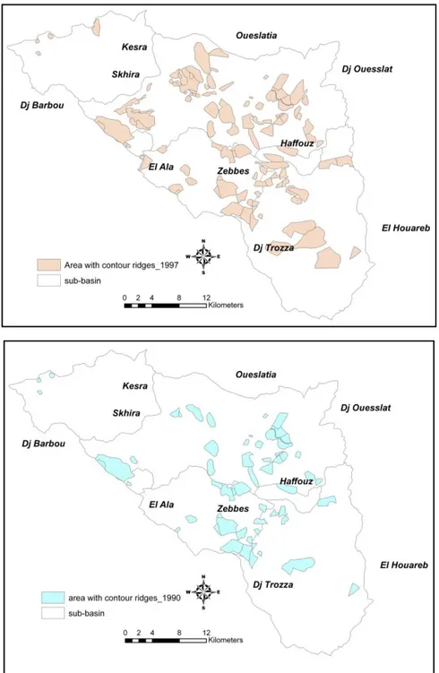
3.2.8.2 CONTOUR RIDGES ... 54
3.3 THE HYDROLOGIC SIMULATOR (SWAT) ... 58
3.3.1 MODELING APPROACH AND STRUCTURE ... 59
3.3.2 PLANT GROWTH ... 62
3.3.3 EROSION AND SEDIMENT TRANSPORT ... 65
3.4 SWAT SETUP ... 67
3.4.1 MODEL INPUT ... 67
3.4.1.1 DIGITAL ELEVATION MODEL ... 68
3.4.1.2 HYDROGRAPHIC NETWORK ... 69
3.4.1.3 LAND USE AND SOIL MAPS ... 70
3.4.1.3.1 LAND USE MAP... 70
3.4.1.3.2 SOIL MAP ... 71
3.4.1.3.2.1 ADJUSTMENTS TO SOILS PARAMETERS ... 72
3.4.1.3.2.2 SOIL HYDROLOGIC GROUPS ... 73
3.4.1.4 CLIMATIC DATA ... 74 3.4.1.4.1 RAINFALL GAGE ... 74 3.4.1.4.2 TEMPERATURE GAGE ... 77 3.4.1.5 RESERVOIRS ... 77 3.4.1.6 PONDS ... 79 3.4.1.7 POTHOLES ... 81
3.4.1.8 CROP MANAGEMENT OPERATIONS ... 83
3.4.2 MODEL SETUP ... 83
3.4.2.1 SUBBASIN DELINEATION ... 83
xiv
3.4.2.3 HYDROLOGICAL RESPONSE UNITS ... 86
3.4.2.3 WEATHER DATA AND SIMULATION ... 88
CHAPTER 4 RESULT AND DISCUSSION ... 90
4.1 SWAT SIMULATION ... 90
4.1.1 SENSITIVITY ANALYSIS ... 90
4.1.2 CALIBRATION AND VALIDATION ... 92
4.2 WATER BALANCE ... 98
4.3 WATER QUALITY SIMULATION ... 99
4.3.1 EVALUATION OF ANNUAL SEDIMENT ... 101
4.3.2 EVALUATION OF MONTHLY SEDIMENT ... 102
4.3.3 EVALUATION OF ANNUAL ORGANIC NITRATE AND ORGANIC PHOSPHORUS ... 104
4.3.4 EVALUATION OF ANNUAL MINERAL NITRATE AND PHOSPHORUS ... 105
4.5 MEASURED VIRUS SIMULATED NUTRIENTS ... 107
4.6 IMPACT OF SOILS ... 109
4.7 IMPACT OF LAND-USE/LAND-COVER ... 109
CHAPTER 5 ALTERNATIVE SCENARIOS ... 111
5.1 SCENARIO 1: REMOVING CONTOUR RIDGES ... 111
5.1. 1 IMPACT OF SWCW ON WATER BALANCE AND SEDIMENT LOADING .... 111
5.1.2 IMPACT OF CONTOUR RIDGES ON SEDIMENT RETENTION IN THE RESERVOIRS ... 117
5.1.3 IMPACT OF CONTOUR RIDGES ON CROP YIELD ... 118
CONCLUSION 1 ... 121
5.2 SCENARIO 2: REDUCTION OF THE FERTILIZER AMOUNT ... 122
CONCLUSION 2 ... 123
5.3 SCENARIO 3: CLIMATE CHANGE SCENARIO ... 124
5.3.1 FUTURE CLIMATE DATA AND MODEL SCENARIOS ... 124
5.1.2 DOWNSCALING CLIMATE VARIABLE ... 126
5.1.3 IMPACT OF CLIMATE CHANGE ON TEMPERATURE AND PRECIPITATION DISTRIBUTION ... 131
xv
5.3.5 IMPACT OF CLIMATE CHANGE ON THE YIELD PRODUCTION ... 137
5.3.6 IMPACT OF CLIMATE CHANGE ON FLOW REGIME ... 138
5.3.6.1 INDICATORS OF HYDROLOGIC ALTERATION (IHA) ... 138
5.3.6.2 FLOW REGIME ALTERATIONS UNDER CHANGING CLIMATE ... 139
CONCLUSION 3 ... 143
CONCLUSION ... 146
REFERENCES ... 148 APPENDICES ... 1-A
xvi
LIST OF FIGURES
Figure 2.1 The catchment of the Mediterranean Basin (Source: Reproduced in Grenon and
Batisse (1989)). ... 8
Figure 2.2 Köppen climate classification... 9
Figure 2.3 Annual course of precipitation at some stations in Tunisia after WMO (1999) ... 11
Figure 2.4 Schematic representation of the hydrologic cycle. (USGS) ... 17
Figure 2.5 Tank model of soil hydrology ... 20
Figure 2.6 Conventional (simplified) procedure for local rainfall-runoff modeling ... 28
Figure 2.7 The concept of model calibration as an optimization problem ... 31
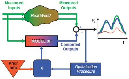
Figure 2.8 Linkage of data, model and parameter estimation (calibration) (Sorooshian et al. 2008) ... 33
Figure 3.1 Location of the study area ... 42
Figure 3.2 Soil map of the Merguellil catchment ... 45
Figure 3.3 Land use map of the Merguellil catchment (Direction Générale des Forêts, 1996) .... 46
Figure 3.4 Spatial distribution of precipitation in the Merguellil catchment ... 48
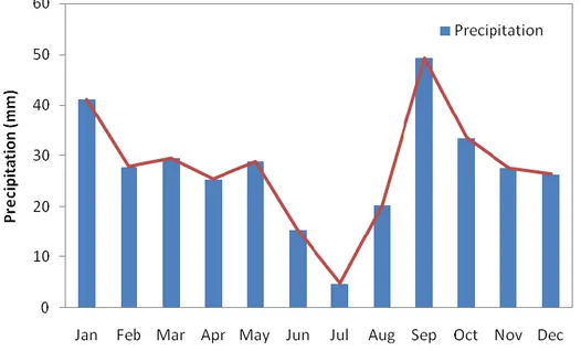
Figure 3.5 Mean monthly precipitations in the Merguellil catchment based on measured data in all rain-gages from 1990 to 2005 ... 48
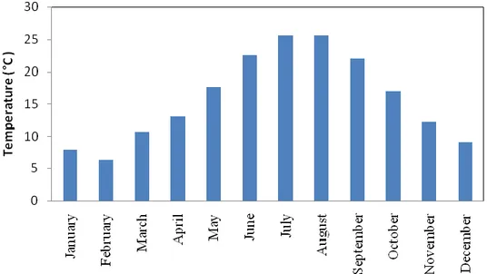
Figure 3.6 Mean monthly temperatures in the Merguellil catchment based on measured data in Sbiba, Makther and kairouan stations from 1972 to1982 ... 49
Figure 3.7 Trends in R-B Index at the Skhira basin (De Giorlamo et al., 2008) ... 52
Figure 3.8 Large and small dams (hill pond and hill reservoir) in the Merguellil catchment ... 54
Figure 3.9 Evolution of the area converted to contour ridges in the Merguellil catchment ... 58
Figure 3.10 Schematic representation of a HRU hydrologic cycle (Source: Neitsch et al., 2001)62 Figure 3.11 SWAT model Input ... 67
Figure 3.12 Digital Elevation Model of the Merguellil catchment ... 68
Figure 3.13 Hydrographic network of the Merguellil catchment (Monat, 2000) ... 69
Figure 3.14 Updated land use map of the Merguellil catchment ... 70
Figure 3.15 Updated Soil map of the Merguellil catchment ... 71
Figure 3.16 Soil texture in the Merguellil catchment ... 72
Figure 3.17 Percent area of soils in the Merguellil catchment. Soils are divided into groupings according to clay content, by percent weight ... 74
Figure 3.18 Discontinuities in daily rainfall ... 76
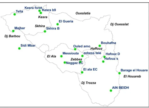
Figure 3.19 Location of the rain-gages in the Merguellil catchment ... 76
Figure 3.20 Components of a reservoir with flood water detention features (After Ward and .... 78
Elliot, 1995). ... 78
Figure 3.21 Location of pothole and hydrologic response Unit in the landscape (Du et al., 2005) ... 82
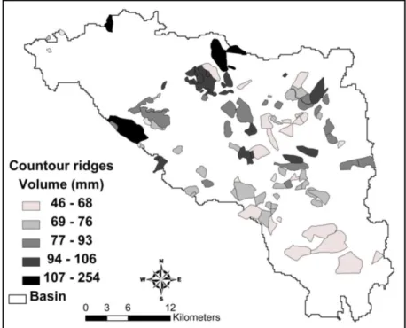
Figure 3.22 Spatial repartition of water storage capacity (mm) of the contour ridges in the Merguellil catchment ... 82
Figure 3.23 Main stream Network with the added outlet ... 84
Figure 3.24 Subbasins delineation in the Merguellil catchment ... 85
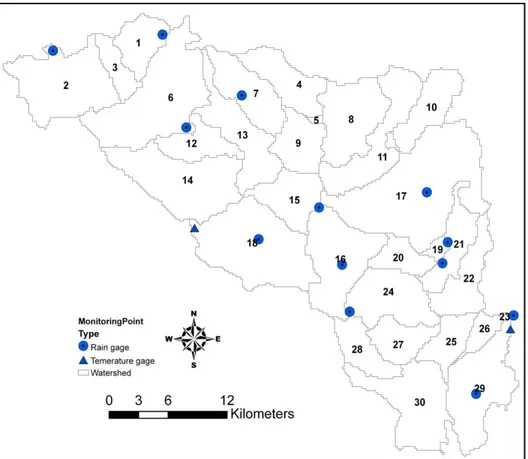
Figure 3.25 land use distribution within the Merguellil catchment after classification in SWAT 88 Figure 3.26 Selected Rain-gages and temperature gages that cover the 30 subbasins ... 89 Figure 4.1Modeled (thick line) and observed (dashed line) stream-flow (m3/s) during the
xvii
calibration (a) and validation (b) periods at Skhira Kef Labiodh flow-gauge. ... 95
Figure 4.2 Modeled (thick line) and observed (dashed line) stream-flow (m3/s) during the calibration (a) and validation (b) periods at Haffouz telepherique flow-gauge ... 96
Figure 4.3 Correlation between measured and simulated stream flow at Skhira and Haffouz flow-gauges during the calibration and validation period. ... 97
Figure 4.4 Water balance in the Merguellil catchment ... 99
Figure 4.5 Average monthly loads simulated at the outlet for the period (1990-2005) ... 101
Figure 4.6 Annual variations of sediment load and concentration simulated at the outlet of the Merguellil catchment ... 102
Figure 4.7 Annual variation of sediment load and flow simulated at the outlet of the Merguellil catchment ... 102
Figure 4.8 Monthly variation of sediment load and concentration simulated at the outlet of the Merguellil catchment ... 103
Figure 4.9 Monthly variation of sediment load and flow simulated at the outlet of the Merguellil catchment ... 104
Figure 4.10 Annual variation of Organic nitrate load and flow simulated at the outlet of the Merguellil catchment ... 105
Figure 4.11 Annual variation of Organic Phosphorus load and flow simulated at the outlet of the Merguellil catchment ... 105
Figure 4.12 Annual variation of mineral nitrate load and flow simulated at the outlet of the Merguellil catchment ... 106
Figure 4.13 Annual variation of Mineral phosphorus load and flow simulated at the outlet of the Merguellil catchment ... 107
Figure 4.14 Annual variation of mineral nitrate load and concentration simulated at the outlet of the Merguellil catchment ... 107
Figure 4.15 Measured virus simulated nutrients (mineral phosphorus, Ammonium and Nitrate) at the Skhira station... 108
Figure 4.16 Measured virus simulated nutrients (Ammonium NH4 and mineral phosphorus MNP) at the Kissra station. ... 108
Figure 4.17 Average annual yields of the various components of the water balance according to clay content of soils. ... 109
Figure 4.18 The portion contributed to the total annual yields by different land-cover ... 110
Figure 5.1 Impact of potholes on surface runoff... 112
Figure 5.2 Impact of potholes on total water yield ... 113
Figure 5.3 Impact of potholes Water volume at the outlet ... 113
Figure 5.4 Impact of pothole on surface runoff reduction ... 114
Figure 5.5 Impact of pothole on surface groundwater ... 115
Figure 5.6 Impact of pothole on Total Water Yield... 115
Figure 5.7 Impact of pothole on Sediment load ... 116
Figure 5.8 Impact of pothole on Organic Nitrate ... 116
Figure 5.9 Impact of pothole on Organic Phosphorus ... 117
Figure 5.10 Impact of potholes on sediment retention in the five reservoirs within the watershed ... 117
Figure 5.11 Impact of pothole on Durum wheat‘s yield ... 120
Figure5.12 Impact of pothole on Olive‘s yield ... 120 Figure 5.13 Impact of pothole on the olive yield in one of the potholes (Pot_HRU 151 Sb 20) 121
xviii
Figure 5.14. Tmax calibration on Decmber (a) and Tmin validation on February (b) ... 127 Figure 5.15 25% quantile (a), 75 % quantile (b), maximum temperature (c) and median
temperature and (d) calculated for the minimum temperature at station 1 during the calibration period (1990-2000) ... 129 Figure 5.16 Calibration (a) of PCP downscaled on January (1990-2000) and validation (b) of PCP downscaled for September (1986-1989) ... 130 Figure 5.17 Mean monthly Tmax (°c) of the Merguellil catchment under current climate and downscaled GCM-generated Temperature for station 1 (a-near future and b-far future) and for station 2 (c- near future and d- far future) ... 132 Figure 5.18 Mean monthly precipitations (mm day-1) of the Merguellil catchment at El Houareb barrage station under current climate and downscaled GCM-generated precipitation for different scenarios (a-near future and b- far future). ... 133 Figure 5.19 Seasonal changes in precipitation and temperature under future climate scenarios during the period (2070-2099). [a) SON = September October and November. b) DJF= December, January and February. c) MAM= March, April and May. d) JJA = June, July and August.] ... 134 Figure 5.20 Average total water yield (mm/year) during the simulation period (1986-1990) (a) and the anomaly graphs for A1B, A2 and B1 scenarios for periods 2014-2039 and 2074-2099. ... 137 Figure 5.21 Mean monthly flow of the Merguellil River using simulated flows under current climate and downscaled GCM-generated stream flow. ... 140 Figure 5.22 Timing of the 1-day minimum for the Merguellil River, using simulated flows under current climate and downscaled GCM-predicted stream flows. ... 141 Figure 5.23 Timing of the 1-day maximum for the Merguellil River, using simulated flows under current climate and downscaled GCM-predicted stream flows. ... 141 Figure 5.24 One-, 3-, 7-, 30- and 90-day maxima flows (A) and minimum flows (B) for the Merguellil River, using simulated flows under current climate and downscaled GCM-predicted stream flows. ... 142 Figure 5.25 Coefficient of variation for mean monthly flow of the Merguellil River using
xix
LIST OF TABLES
Table 2.1 Mean surface air temperature and precipitation regime of the Mediterranean basin
according to the European Climate Support Network (1995). Reference period 1960-1990 ... 10
Table 3.1 Summary of streamflow gauging stations ... 50
Table 3.2 Overview of Indices results and some characteristics of the Merguellil catchment on the Skhira Kef labiodh flow-gauge (De Girolamo et al., 2008)... 51
Table 3.3 Surface area converted to contour ridges in the Merguellil catchment from 1970 to 1998... 56
Table 3.4 Soil hydrological group ... 74
Table 3.5 Rain-gages name and coordinate ... 75
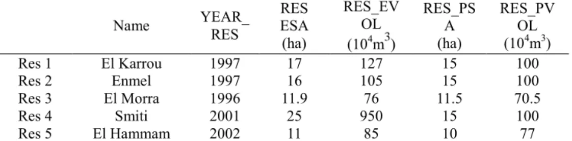
Table 3.6 Characteristics of 5 large reservoirs included in the SWAT model ... 79
Table 3.7 Outlets coordinates ... 84
Table 3.8 Corresponding name and code in SWAT for each land use type in the Merguellil catchment ... 86
Table 3.9 SWAT Distribution of soil and land use classes in the Merguellil catchment ... 87
Table 4.1 Ranking of the six most sensitive parameters (1= most sensitive) ... 91
Table 4.2 Best parameter values ... 94
Table 4.3 Annual values of NSE and R2 for the two flow gauges. ... 98
Table 4.4 Predicted water balance from 1990 to 2005 (SURF Q= surface runoff, ET= actual evapotranspiration, ETP= potential evapotranspiration) ... 99
Table 4.5 Land use contribution to water and nutrient balance ... 110
Table 5.1 Impact of potholes on water balance and sediment loading ... 112
Table 5.2 Impact of potholes on crop yield ... 118
Table 5.3 Estimated effects of reduction fertilizer application (20%) on the crop yield. ... 123
Table 5.4 Nutrient loads (T/year) at the outlet for the baseline and scenario 1 and the reduction percentage ... 123
Table 5.5 Seasonal average precipitation (mm month-1) and temperature (°C) during the historical period (1986-2005) at catchment scale ... 134
Table 5.6 Water balance component based on historical data of (1986-2005) and future climate scenarios. ... 135
xx
LIST OF PHOTOS
Photo 3.1 El Houareb Dam on May 2007 (left) and on May 2008 (right) ... 42 Photo 3.2 Siltation of El Maiz pond Photo 3.3 El Morra reservoir ... 54 Photo 3.4 Contour ridges in the Merguellil catchment Photo 3.5 water retention by contour ridges ... 56
LIST OF APPENDICES
Appendix 1 Soil profiles (Direction des sols 1963-1982) ... 1-A Appendix 2a Point Analysis for soil samples (Dridi, 2000) ... 12-A Appendix 2b Analysis result for soil characteristics (Dridi 2000) ... 12-A Appendix 3 Soil profiles characteristics in the Merguellil catchment ... 13-A Appendix 4 Textural triangle ... 28-A Appendix 5 Ponds characteristics ... 29-A Appendix 6 Potholes characteristics ... 29-A Appendix 7 Land management practice data procured from interviews. ... 31-A Appendix 8 Crop management operations ... 34-A Appendix 9 Database for the Olive tree plant growth ... 35-A Appendix 10 Runoff curve number for cultivated agriculture lands. ... 36-A Appendix 11 Linear and non linear regression. ... 37-A Appendix 12 Calibration and validation of downscaled CGCM ... 40-A
xxi
ABBREVIATIONS AND ACRONYMS
AI Aridity Index
AIM Mediterranean Isoclimatic Area ARS Agricultural Research Service EEA European Environment Agency BD Bulk Density
BF Baseflow Index,
CES Conservation Des Eaux Et Du Sol.
CGCM Generation Of The Canadian Global Coupled Model CO2 Carbon Dioxide
DCV Daily Variation Coefficient DEM Digital Elevation Model DGF Direction Générale Des Forêts
DGRE Direction Générale Des Ressources En Eaux ET Evapotranspiration
GIS Geographic Information System
GLUE Generalised Likelihood Uncertainty Estimation GTZ Technische Zusammenarbeit Gmbh
HEC1 Hydrologic Engineering Center HOF Hortonian Overland Flow HU Heat Unit
HRUS Hydrologic Response Units
IHA Indicators Of Hydrologic Alteration
IPCC Intergovernmental Panel On Climate Change NERC Natural Environment Research Council PPM. Parts Per Million
PRMS Precipitation-Runoff Modeling System R-B Index Richards-Baker Flashiness Index R-R Rainfall Runoff
RSA Regional Sensitivity Analysis SCS Soil Conservation Service SOF Saturated Overland Flow
SWAT Soil And Water Assessment Tool UK United Kingdom
USA United State Of America
USDA United States Department Of Agriculture USEPA United State Environmental Protection Agency USGS United States Geological Survey
WMO World Meteorological Organization WSCW Water And Soil Conservation Works LAI Leaf Area Index
PHU Plant Heat Units
PET Potential EvapoTranspiration
MUSLE Modified Universal Soil Loss Equation ESRI Environmental Systems Research Institute
xxii RUE Radiation-Use Efficiency
SCS-CN Soil Conservation Service-Curve Number IGNF Institut Géographique National Français IRD Institut De Recherche Pour Le Développement TP Total Porosity
FC Field Capacity WP Wilting Point
AWC Available Water Capacity
INM Natural Resource Conservation Service NRCS Institut National De Météorologie UTM Universal Transverse Mercator
MARS Monitoring Of Agriculture With Remote Sensing, AVFA Agence De Vulgarisation Et Formation Agricole NSE Nash-Sutcliffe Model Efficiency
R2 Coefficient Of Determination FAO Food And Agriculture Organization NWP Numerical Weather Prediction LM Linear Model
NLM Non Linear Models AET Actual Evapotranspiration
xxiii
LIST OF SYMBOLS
% Percentage
mm/day Millimeter per day
°C Degree Celsius
Mkm2 Million square kilometer
m Meter
°N North
Mm Millimeter
°E East
m3/cm yr Cubic meter per centimeter per year bm3 Billion cubic meter
Mm3 Million cubic meter g/l Gramm per liter ΔS Changes in storage
Q Streamflow
km² Square kilometer
km Kilometer
m3/s Cubic meter per second
mm Millimeter
< Less than > Greater than
mm m-1 Millimeter per meter M3 Cubic meter
mm/year Millimeter per year
Tmax Maximum daily temperature Tmin Minimum daily temperature
Δbio Potential increase in total plant biomass on a given day kg/ha Kilogram per hectare
MJ/m2 Mega joule per meter square
MJ Mega joule
Hphosyn Intercepted photosynthetically active radiation mm/ha Millimeter per hectare
P Precipitation
T Temperature
Sr Solar radiation
Ws Wind speed
T/day Tons per day kg/day Kilogram per day Mg/l Milligram per liter
NO3 Nitrate
NH4 Ammonium
MNP Mineral phosphorus TWY Total water yield
xxiv AQR Aquifer recharge
GWQ Groundwater flow
RES Reservoir
PCP Precipitation
SON September October November DJF December January February MAM March April may
JJA June July august .
1
CHAPTER 1. INTRODUCTION
1.1 PROBLEM STATEMENT
There is a growing consensus in Earth systems sciences that global temperatures are increasing and will continue to increase during the next century, leading to changes in global climate patterns (IPCC, 2002). Different regions of the globe are expected to respond differently to global warming; the Mediterranean region has been identified as one of the Earth‘s primary ‗hot-spot‘ for climate change, due to the magnitude of expected changes to temperature and rainfall patterns (Giorgi, 2006).
Surprisingly, the issue of climatic change in the Mediterranean region has rather sparsely been addressed in studies performed more than 5–10 years ago. The region has recently received increasing scientific interest. In fact, the Mediterranean has some particular characteristics that demand to put it high on the research agenda. There is a high confidence that many semi-arid and arid areas (e.g., the Mediterranean Basin, western USA, southern Africa and northeastern Brazil) are particularly exposed to the impacts of climate due to climate change (IPCC, 2007). These changes in the climate regime can influence natural processes of a watershed ecosystem (Band et al. 1996; IPCC, 2001; Stone et al. 2001) and have long-term implications on economic and ecological processes (USEPA, 2004).
In the Mediterranean climatic zone, also labeled as semi-arid or sub-humid (Piñol et al., 1991), hydrological processes are largely variable both in time and space due to the high variability of rainfall regime, in addition to the influence of topography and the spatial distribution of geology, soil and land-use (Kosmas et al., 1997; Pilgrim et al., 1988; Thornes et al., 1996). The arid and semi-arid regions of the world are experiencing the most intense water scarcity. In North Africa water scarcity is intensified with populations grow and economies develop. Like the most countries in this region, Tunisia exemplifies the general water scarcity problem.
Water management is the most critical issue in dry areas as it impacts the livelihood of people and the productivity of the land and the society in general. For thousands of years, inhabitants of
2
the dry areas have constructed water-harvesting systems that helped them to cope with water scarcity (El Amami, 1984; Boers, 1994; Oweis et al., 2004). These systems were built to capture surface runoff from sparsely covered, rocky mountain slopes or to divert occasional wadi flow to fields for crop production. Despite the long and successful history of these systems, little is known about their effect on the hydrological processes in these dry areas.
The Tunisian government has put considerable efforts into Water and Soil Conservation Works (WSCW) through physical, institutional, and legislative measures for the past three decades. The Ministry of Agriculture enacted a national strategy for soil and water conservation for the decade 1991–2000, based on managing slope stability, gradients and shapes, and transferring surface water for agricultural development. A program was then initiated to construct 1000 hill dams, 4000 structures for flood control and groundwater recharge, to protect 600000 hectares by implementing conservation measures. The implementation of these actions was coupled with regional planning covering a number of governorates.
Generally, Water and Soil Conservation Works (WSCW) are built in uplands to face erosion and water scarcity problems. They consist of hill slope works reducing surface runoff and increasing local infiltration, and of small dams collecting headwater flow and providing supplemental water for irrigation. With the fast growth of WSCW-equipped areas, it becomes necessary to investigate hydrological impacts and manage resources at larger scales, especially where conflicts between upstream and downstream water users increase. In fact, water harvesting systems may intercept runoff at the upstream part of the catchment, thus depriving potential downstream users of their share of the resources (Oweis et al., 1999). An example is the wadi bed system in the Matruh area in northwest Egypt, where the introduction of water harvesting techniques negatively affected water users downstream of the system (Moustafa, 1994). Nasri (2007) demonstrates that a cascade of bench terraces built on a 14.48 ha hill slope do significantly reduce sediment transport on the Ousseltia region of central Tunisia. Nasri et al. (2006) studied the hydrological impact of contour ridges in an 18.1 km2 catchment and on 0.11km2 hill slopes respectively. In both cases, introduction of contour ridges resulted in a runoff decrease varying between 50% and 90% for rainfall below 60-70 mm/day.
3
scarcity increase with catchment size. Despite the critical importance of water in arid and semi-arid areas, hydrological data have historically been severely limited. It has been widely stated that the major limitation of the development of arid-zone hydrology is the lack of high quality observations (McMahon, 1979; Nemec and Rodier, 1979; Pilgrim et al., 1988). Many reasons are behind this data limitation. Populations are usually sparse and economic resources limited; in addition, the climate is harsh and hydrological events infrequent, but damaging (Wheater et al., 2007).
Since limited hydrological information is available in semi arid watersheds, adequate hydrological assessment tools should be flexible to deal with poor quantity and quality input data (Lange and Singh, 2003). One approach to assisting sustainable water resource development and management within river basins is the use of mathematical modeling of watershed hydrology (Singh and Woolhiser 2002). Numerical models of groundwater and surface water resources systems have been used to simulate the behavior of catchment systems since the 1960s (Zoppou, 2001). However, increasing computer speed and the development of new mathematical representations of physical processes has allowed the science of computer simulation to pass from being of academic interest only to a practical engineering procedure (Viessman & Lewis, 2003). The use of hydrological modeling tools to address a wide spectrum of environmental and water resources problems is now commonplace.
1.2 PROJECT HOLDER
This research work is part of a European project ―Aquastress project‖ (6th EU framework
program) about Mitigation of Water Stress through new Approaches to Integrating Management,
Technical, Economic and Institutional Instruments.
The overall goal of this project is to improve the availability of high quality water at catchment scale by assessing different schemes of land use pattern and management. The task has the objective to define a modeling framework to assess sustainability of land uses in water limited environments and to allow the selection of a list of suitable Best Management Practices (both based on non-structural/management and structural approach) that allow that water quality goals discussed and decided with stakeholders are met.
4
1.3 RESEARCH OBJECTIVES
In this thesis, a study on the Merguellil catchment, a Mediterranean semi-arid area with a limited data set in central Tunisia, is presented. Soil and Water Assessment Tool (SWAT) model was used to simulate the water balance and nutrient balance and to assess the impact of land use and land cover activities on the hydrology. Some scenarios were further generated. The first one regards the removal of contour ridges to assess their impact to water and sediment load and crop yield. The second scenario consists in the reduction of the applied fertilizers in order to increase the availability of a god quality of the water in the downstream area.
In such a vulnerable situation of water resources availability, it can be expected that the impact of climate change will further worsen the situation.
In this study we report therefore on the result of investigating the impact of climate change on water resources in the Merguellil catchment (central Tunisia) for the near (2010-2049) and far (2050-2099) future. We used the Soil and Water Assessment Tool Model (SWAT 2005) to study the effect of climate change at subbasin level. We used the output of the third Generation of the Canadian Global Coupled Model (CGCM 3.1) version T63. We specifically looked at the changes in various components of the water balance including precipitation, evapotranspiration, total water yield, soil moisture and river discharge. In addition the impact of climate change on olive and wheat yield was also investigated. Finally, we analyze the flow regime alterations under changing climate using the Richter et al.‘s (1996) Indicators of Hydrologic Alteration (IHA).
1.4 SCHEMATIC PRESENTATION OF THE THESIS
This work is presented in five chapters. In the first one, after a brief introduction of the problem statement, the research objectives were presented. In the second one, the literature review presents the Mediterranean climate, Problems of water resources in this region with special focus on Tunisia. In addition, Water balance Components are explained as well as the hydrologic modeling approaches. Another part points out the problem of data scarcity in semi-arid areas. Finally, the last part of this chapter highlights the impact of climate change on Mediterranean water resources.
5
In the Third chapter, the study area was presented, as well as the available data base such as the DEM, soils, land uses, climatic characteristics, and Water and Soil Conservation Works (WSCW). In addition, we carried out a study on the temporal and spatial repartition of precipitation in the catchment. We report also some results about the hydrologic regime in the study area. In a second part, we describe the SWAT model and the required input data indicating the different equations used and the different procedure of the simulation. Another part is devoted to the preparation and the adjustment of the input data and how we model the different WSCW presented in the catchment. In the last part of this chapter, we describe the different steps of the SWAT model setup.
A Summary of the results obtained from the SWAT model simulation is the subject of chapter 4. These results include the sensitivity analysis conducted, the calibration and validation of the model comparing the measured and simulated flow in different flow gauges. Afterward, the water balance in the Merguellil catchment is presented as well as the nutrient quality simulation. The evaluation of sediment and nutrient was also outlined. Finally the impact of soils and land use on hydrologic and nutrient balances are highlighted in the end of this chapter.
In the firths and last chapter, we try to take into account all the stresses (climatic and anthropogenic) that the Merguellil catchment is facing. In view of this, some scenarios were generated. First one consists on in the removal of contour ridges from the upstream area the in order to assess the impact of these regulation on the on the hydrological regime, sediment retention and crop yield. Second one consists on the reduction of the applied fertilizers in order to improve water quality.
In the Last part of this study, we report on the result of the investigation of the impact of climate change on water resource of the Merguellil catchment. We used the output of the third Generation of the Canadian Global Coupled Model (CGCM 3.1) version T63.
In addition the impact of climate change on olive and wheat yield was also investigated. Finally, we analyze the flow regime alterations under changing climate using the Richter et al.‘s (1996) Indicators of Hydrologic Alteration (IHA).
6
The application of the SWAT model for the Merguellil catchment confirms that SWAT is a useful tool that can already be used to make preliminary assessment of the water and land management of the basin.
7
CHAPTER 2. LITERATURE REVIEW
2.1 MEDITERRANEAN CONTEXT
The Mediterranean basin is a transition area covering the Mediterranean Sea as such and land encompassing it, limited by deserts to the south and temperate areas to the north (Figure 2.1). The Mediterranean type of climate spread not only on the Mediterranean basin but cover also areas in South Africa, Chile, Mexico, USA, and South Australia. The connotation of ‗‗Mediterranean climate‘‘ is included in the qualitative classification of the different types of climate on Earth (e.g. Köppen, 1936) and it has been used to define the climate of other (generally smaller) regions besides that of the Mediterranean basin itself. It includes a range from arid, through semi-arid to sub-humid conditions. According to the Köppen scheme (Figure 2.2) most areas of the Mediterranean fit into the dry or warm, temperate climate zones. However, it has been demonstrated that the boundaries produced by the Köppen scheme are highly sensitive to the data set used to define it. Emberger proposed simple boundaries to the climate region using an index calculated by dividing the summer rainfall in mm by the average maximum temperature of the warmest month in degrees Celsius. A value of five delimited the Mediterranean climate zone, with seven being the boundary of the sub-Mediterranean zone. Although this scheme works well for the northern part of the basin, it is completely inappropriate for the south, delimiting the limits of the Mediterranean zone in the middle of the Sahara. Daget (1980) defined a compromise based on the ratio of warm-season to cold-season precipitation and the summer concentration of temperatures. The ‗Mediterranean Isoclimatic Area‘ (AIM in French) is thus defined, providing better fit to the region as a whole, including the semi-arid zones of North Africa. However, although this is probably the best definition of the Mediterranean climate, there is still a feeling that it is derived empirically, rather than being based on any good a priori reasons. A typical‘ Mediterranean vegetation is often used as a definition of the Mediterranean region. The olive is very commonly used as an indicator species, but, its distribution is also very strongly controlled by human activity in the past and present. Other authors have chosen to use country boundaries or other political or administrative boundaries. Such a definition is also somewhat artificial. If the smallest administrative level is
8
chosen, large areas of the hinterland that are vital to Mediterranean socioeconomic systems are cut off. These levels also differ from country to country. If the country level is chosen, then clearly some areas are included that clearly do not share Mediterranean characteristics of any sort – northern France and the south of Libya and Egypt being the clearest examples here. The administrative units also differ vastly according to the country chosen (reflecting in part the different population densities and their spatial distributions).
In summary, none of these simple definitions of the region are really satisfactory. All include important elements and exclude others. None so far has included Portugal, for example, despite the fact that it shares a number of common traits with the rest of Iberia and the region. The Mediterranean has been a cross-roads, both physically and socially. It has marked a place where plate boundaries have met, air masses mixed, plants combined from different regions and evolved into endemic species, and people have developed new ways of life and spread them to Europe and beyond. Subsequently, the interactions with the wider world have had significant impacts on the peoples and environments of the region. As noted above, it is partly because of this rich and varied heritage that the Mediterranean is an interesting and useful environment to study.
Figure 2.1 The catchment of the Mediterranean Basin (Source: Reproduced in Grenon and Batisse (1989)).
9
Figure 2.2 Köppen climate classification
The Mediterranean type of climate is characterized by contrasting variations in temperature and precipitation between winter and summer, and prone to extremes. Winters are cool and relatively wet. While summers are warm and dry with a strong soil water deficit. The average temperature of the hottest month can be >22 °C. In the Mediterranean region the strong difference between the wet winters and the dry summers is caused by the seasonal alternation of the dominance of cyclonic storms in winter and subtropical high pressure cells over the adjacent ocean in summer with subsiding maritime tropical air causing dry conditions in summer. The Mediterranean climate in most regions is confined to narrow coastal belts. Only in the European/African/Near East area, because of the Mediterranean Sea, it covers about 10 Mkm2 reaching from Portugal to south of the Caspian Sea with a core area that stretches over 46 degrees longitude and covers about 6 Mkm2. Of this area 2.496 * 106 km2 belong to the Mediterranean Sea surface. If the
10
Black and Marmara Seas are counted as well, the sea surface covers 3.1 *106 km2. The general temperature and precipitation distribution in the European/African Mediterranean basin is presented in Table 2.1.
Table 2.1 Mean surface air temperature and precipitation regime of the Mediterranean basin according to the European Climate Support Network (1995). Reference period 1960-1990
Quantity
Season European lowlands European highlands North African coastal zone Sea winter 7.5 ± 2.5 2.5 ± 2.5 12.5±2.5 15 ±5 Temperature spring 12.5 ±2.5 7.5 ± 2.5 17.5 ±5 15 ±5 (°C) summer 22.5 ± 2.5 15 ±5 32.5 ± 10 22.5 ± 5 autumn 17.5 ±2.5 10 ±5 20 ±5 20 ±5 winter 1-3 3-10 0.25 - 2 2 - 10 Precipitation spring 1 -3 3 - 10 0-2 0-2 (mm/day) summer 0- 1 1 -3 0 - 0.5 0-1 autumn 1 - 5 2-10 0-2 0.5 - 5
The climate gradient across the Mediterranean basin is extreme. It ranges from the cold mountainous areas of the Alps with annual mean temperatures below zero (-2 °C at 2500 m elevation) to the hot plains of Africa with annual mean temperatures up to about 22 °C even near the coast and 32.5 °C inland (25.5 °N) (Bolle, 2003). Inland the annual maximum temperatures are reached in July while at the coast it is delayed to August which indicates the effect of the sea on the climate (Bolle, 2003).
The amplitude of the temperature wave is larger at the dry inland stations as compared to Mediterranean coastal sites and the differences between the stations are larger in summer than in winter. The Mediterranean basin also contains the sites with highest European annual precipitation of much above 1000 mm at the eastern Adriatic coast and its hinterland (4600 mm near 42.8 °N, 22.3 °E) and less than 100 mm in North Africa at 32 °N (Bolle, 2003 ).
In Figure 2.3, the annual course of average rainfall across Tunisia is presented. It shows the gradient from the highest winter precipitation at the northwestern coast to the eastern coast and the inland. Remarkable is that at the more southern stations often the winter precipitation maximum is not in December or January but in October and March. The spatial variability of the
11
Mediterranean climate is high even at relatively small spatial scales.
Figure 2.3 Annual course of precipitation at some stations in Tunisia after WMO (1999)
2.2 WATER RESOURCES IN THE MEDITERRANEAN: MAJOR
PROBLEM FACETS
Water resources are a huge topic and a very important one, because water impinges on virtually every aspect of daily life. Most of the Mediterranean regions are water poor and prone to water shortages. The Mediterranean climate is considered the main source of water scarcity in these regions. In fact, with long periods of hydrologic deficit and high levels of inter-annual variability in rainfall, in addition to long periods of over-exploitation, the issue of water shortage is exacerbated. During the last decades, fresh water is becoming scarcer and more unequally distributed in the Mediterranean basin countries (Wainwright and Thornes, 2004).
Climate change, the growing demand for water in agricultural and urban development, as well as the expanding tourism industry, have further increased the pressure on water resources and hence aggravated the water stress on the region. Population growth in many southern Mediterranean countries is the major factor affecting water resources, reducing the water availability per capita. Urbanization increases urban demands, which are of high-priority and intensifies conflicts
12
among users. Tourist population in the Mediterranean is very significant, and tourist water consumption is about three times higher than local demands (EEA, 2000).
These rapid social and environmental changes will have negative implications towards current and future sustainability. Pressures and impacts of water scarcity often result in conflicts among users and with an apparent lack of policy response towards sustainable management, due to the complex institutional structure and legislation (Garrote et al. 2005; Iglesias and Moneo 2005; Garrido and Llamas 2006). UN projections (UN Population Division, 1994) show that four Mediterranean countries already have less than the minimum required water availability to sustain their own food production (295 m3/cm yr). By 2025, eight countries will be in virtually the same situation. These countries are essentially all on the Southern rim of the Mediterranean basin.
In the Mediterranean region, agriculture is considered to be the sector where the largest volume of water can be saved. Agriculture accounts for some 80 % of total demand and large amounts of water are poorly used. In many areas, agriculture is impossible without irrigation (Papadopoulos, 1995). Consequently the conventional water resources will be insufficient to even meet the domestic water demand at the beginning of the next century and the need for alternative water resources such as reuse of waste water is unavoidable.
Towards acute water shortage in the Mediterranean basin, water experts and politicians agreed that water management problems must be addressed immediately and they not an exclusive matter of water quantity but also of water quality. In recent years water pollution has become a high priority issue for the protection of the quantity and the quality of the surface water and groundwater resources. Degradation of the groundwater quality is a common problem in the Mediterranean region due to multiple pressures on the aquifers: excessive pumping in relation to average natural recharge, return flow from irrigation water with intense use of agrochemicals, leakage from urban areas, landfills, septic tanks, sewers, mine tailings, among others (Barraque 1998; Fornes et al. 2005). Also irrigated agriculture in semi-arid regions, although increases crop productivity and economic stability, however, it is one of the major diffuse source contributors to the contamination of surface and groundwater bodies, mainly from pesticides and fertilizers.
13
Control of pesticides and optimization of fertilization with crop uptake are essential management strategies for better control of irrigated agriculture. Drought episodes also contribute to the degradation of groundwater quality (Iglesias and Moneo 2005) as a result of the overuse of aquifers. An important number of Mediterranean wetlands are affected by irrigation activities since their ecosystems depend to a significant degree on the sustainability of agro-ecosystems. Habitats‘ conservation and agriculture have in many cases irreconcilable interests (Hellegers and van Ierland 2003). Many aquifer systems that naturally contain vast quantities of brackish water, have limited possibilities for exploitation for human or agricultural uses, imposing so, additional demand stress to neighboring aquifers with higher water quality. Also saline intrusion is an important concern in aquifers, especially in the Mediterranean region, where as a result of the high seasonal water demand, mainly for tourism, they have been over pumped.
2.3 WATER RESOURCES IN TUNISIA
2.3.1 RAINFALL AND SURFACE WATER POTENTIAL
Surface water resources in Tunisia are characterized by problems of quantity and quality. These resources are limited because of the semi-arid to arid climate found in most of the country, with episodic droughts, and a natural deterioration of water quality because of the salty types of rocks found within the country (Benabdellah, 2007).
Tunisia receives on average 230 mm/year of rainfall; that is 36 billion cubic meters (bm3) of rainfall. However, this volume varies between 11bm3 during a drought year and 90 bm3 during a very wet year.
The variability of the climate under the Mediterranean influence in the north and under the Saharan influence in the south makes rainfall at the same time scarce and unequally distributed in space and time. The annual precipitation is on average 594 mm in the north, 289 mm in the center and only about 150 mm in the south. The ratio between the highest observed values and the lowest observed values of precipitation vary from 4.4 in the north to 15.8 in the south, illustrating the temporal irregularity and variability of rainfall. The decade beginning in 1990 had 4 dry years, one very wet year (1995-96), three relatively wet years and two average rainy years. In the southern part of the country, this decade was rather a dry one. Rainfall information has