See discussions, stats, and author profiles for this publication at: https://www.researchgate.net/publication/290445236
2008–2011 snow cover area (SCA) variability
over 18 watersheds of the central Chile through
MODIS data
ARTICLE in GEOGRAFIA FISICA E DINAMICCA QUATERNARIA · JANUARY 2015 Impact Factor: 0.63 · DOI: 10.4461/GFDQ.2015.38.15 READS3
8 AUTHORS, INCLUDING: Umberto Minora University of Milan 6 PUBLICATIONS 10 CITATIONS SEE PROFILE Daniele Bocchiola Politecnico di Milano 90 PUBLICATIONS 817 CITATIONS SEE PROFILE Claudio Smiraglia University of Milan 145 PUBLICATIONS 1,384 CITATIONS SEE PROFILE Guglielmina Adele Diolaiuti University of Milan 102 PUBLICATIONS 1,070 CITATIONS SEE PROFILEAbstrAct: Minora U., Godone d., Lorenzini S., d’aGata C., BoC -ChioLa d., BarCaza G.S., SMiraGLia C. & dioLaiUti G.A., 2008–2011
snow cover area (SCA) variability over 18 watersheds of the central Chile through MODIS data. (IT ISSN 0391 – 9838, 2015)
Snowmelt contributes largely to water budget of several Chilean mountain watersheds. To describe snow covered area (SCA) variability within 18 watersheds in Central Chile during 2008–2011 we used MODIS data (i.e. MOD10A2-V5 maximum snow cover extent in eight-day peri-ods). The study area was divided into three different zones (Northern, Central, and Southern), due to its large extent (~205,000 km2), and
ac-cording to former studies performed by the Direccíon General de Aguas (DGA) of the Chilean Government covering the time window 2000–2007. After georeferencing our data to the WGS84 Datum (UTM Projection, zone 19S), the scenes were cropped to fit the study area. We selected and set a threshold for cloud coverage (<30%) in order to discard the images with too cloud cover, so losing only 2% of the sample. Hypsographic and aspect analyses were performed using the SRTM3 elevation model. We found largest values of SCA during 2008–2011 in the Central Zone, while the topographic and climatic features (i.e. lower altitudes in the South, and a drier climate in the North) limit snow deposition elsewhere. Simi-larly, snow line is higher in the Northern zone (due to the presence of the plateau), and lower moving southwards. In the North the minimum SCA
is reached sooner than elsewhere, lasting for a longer period (November to March). West side showed the maximum of SCA in all zones through-out the study period. The present work extends in time the dataset of SCA in the Central Chile, adding information for statistic assessment, and trend analysis of snow cover in this area.
Key WordS: Snow covered area (SCA), Remote sensing, MODIS,
Central Chile.
resumen: MINORA U., GODONE D., LORENZINI S., D’AGATA C., BOCCHIOLA D., BARCAZA G.S., SMIRAGLIA C. & DIOLAIUTI G.A., Estudio de la cubierta nival sobre 18 cuencas hidrograficas Chilenas nel periodo 2008-2011 con análisis de datos MODIS. (IT ISSN 0391 – 9838, 2015)
La fusión nival contribuye en manera importante en el balance hi-drologico en muchas cuencas de montaña Chilenas. Para describir la va-riabilidad de cubierta nival (SCA, o sea snow covered area) y aumentár el conocimiento de esta variable en 18 cuencas Chilenas, se análisaron datos MODIS (o sea MOD10A2-V5, la maxima cubierta nival en 8 dias). El area de estudio (ca. 205 000 km2) se dividió en tres zonas (Norte, Sur,
Centro), come se hize en un estudio anterior, publicado por la Dirección General de Aguas (DGA) del gobierno Chileno, que ha analizado recien-temente las mismas cuencas en el periodo 2000-2007. Los datos MODIS fueron geo-referenciados en el sistema WGS84 (UTM Projection, zona 19S). Se ha aplicado un umbral por la cubierta nuvolosa (30%) para des-cartar las imágenes demasiado cubiertas, con reducción de la muestra utilizable de 2% sólo. Para analizar la cubierta nival encuentra de la topo-grafía y de la exposición se usarón datos de levantación por el Modelo de Elevación Digital (DEM) SRTM3. Los resultados indican que los maxi-mos valores de SCA por el 2008-2011 se vieron en el centro, mientras que factores topografícos y climaticos (o sea levantación en medio mas bajas en el Sur y precipitaciónes mas reducidas en el Norte) límitan la cubierta nival en otros sectores. La línea de la nieve es mas alta llendo hacia el Sur. En el Norte el SCA minimo se encuentra primero que en los sectores Sur y Centro, además durand mas tiempo. Exposición hacia el Oeste mues-tran el maximo de la cubierta nival en todas las zonas estudiadas y para todo el periodo analizado. Este estudio ha permitido de ampliar el banco de datos sobre la cubierta nival en 18 cuencas hidrograficas Chilenas y de ayudar el conocimiento de la variabilidad recente de un parámetro hidrológico fundamental.
PaLaBraS CLaveS: Area cubierta de nieve (SCA), Teledetección,
MO-DIS, Chile.
Geogr. Fis. Dinam. Quat. DOI 10.4461/GFDQ.2015.38.15
38 (2015), 169-174, 4 figg., 1 tab.
U
MBertoMINORA (*,**,***), d
aniLoGODONE
(*,****), S
andraLORENZINI (*),
C
arLoD’AGATA (*,**), d
anieLeBOCCHIOLA (*,***), G
onzaLoSEPULVEDA BARCAZA
(*****), C
LaUdioSMIRAGLIA (*,**) & G
UGLieLMinaa
deLeDIOLAIUTI (*,**)
2008–2011 SNOW COVERED AREA (SCA) VARIABILITY
OVER 18 WATERSHEDS OF THE CENTRAL CHILE
THROUGH MODIS DATA
————————
(*) Comitato EvK2CNR, Bergamo, Italy.
(**) Dipartimento di Scienze della Terra, Università degli Studi di Mila-no, Italy ([email protected])
(***) Politecnico di Milano, Italy.
(****) Research Centre on Natural Risks in Mountain and Hilly Envi-ronments (NatRisk), Università di Torino, Italy.
(*****) Dirección General de Aguas, Ministerio de Obras Pùblicas, San-tiago, Chile.
corresponding author: [email protected]
The presented results were carried out under the umbrella of a scientific collaboration project named “Plan de Acciòn para la conservacion de glaciares ante el cambio climatico”. This project was supported by an international an-nouncement of Inter-American Development Bank. Principal investigators: G. Diolaiuti (Glaciology) and D. Bocchiola (Hydrology). Project manage-ment was performed by the Association Ev-K2-CNR (Italy). The scientific and technical collaboration was provided by the Dirección General de Aguas (Ministerio de Obras Pùblicas, Santiago, Chile).
INTRODUCTION
In mountainous basins with temperate or mediterranean climate, large volumes of snow can be stored at higher el-evations, and subsequently be released during Spring and Summer snowmelt events (Verbunt & alii, 2003). This natu-ral process is critical for sustaining agricultunatu-ral activities, hydropower production, urban water supplies and wildlife habitats. However, in the case of the Chilean Andes there is a lack of both meteorological input and hydrological valida-tion data, which complicates the analysis of those hydrologi-cal processes (Sther & alii, 2009).
Here we try to fill this gap using the Moderate Reso-lution Imaging Spectroradiometer (MODIS) sensor to es-timate the snow cover variability during 2008–2011 within 18 catchments in Central Chile. This study furthers a previ-ous work performed by the Direccíon General de Aguas of the Chilean Government (DGA, 2008), which analyzed the same watersheds in the previous 2000–2007 time window with daily MODIS snow data. The use of MODIS imagery can provide a reasonable estimate of snow cover extent, es-pecially in those areas where little ground-observed snow cover information is available (Ghanbarpour & alii, 2007). Godone & alii (2011) have shown that there is good agree-ment between snow cover extent and duration derived from
MODIS, and from in-situ measurements in the northwest-ern Alps. The snow covered area (SCA) is analyzed for tem-poral (with monthly and annual resolutions), and spatial variability (snow cover surface, snow hypsography and as-pects, in altitude belts of 200, and 1000 m).
STUDY SITE
The study area stretches from North-to-South from the Copiapó River (in the Atacama Region), to the Petrohué River (Los Lagos Region), covering to 205,000 km2 (fig.
1), and ca. 15° of latitude in the Southern Hemisphere (26°S–41°S). It includes 18 watersheds (fig. 1). Due to its shape, topography, and location, Chile presents contrast-ing climatic patterns. Mid-latitude Chile is characterized by a semiarid– mediterranean type climate controlled by the seasonal influence of the Southern Westerlies. Precipi-tation values at 33°S range between 400 mm/yr at the coast (Valparaiso) and 1000 mm/yr in the high Andes. To the north precipitation declines whereas southwards signifi-cantly higher values, and lower seasonality, occur in both coastal and mountain areas (Miller, 1976). Snow settles on the Chilean Andes, covering the eastern boundaries of the country.
FiG. 1 - A map of Chile and the study area. The three zones
are shown in dark blue (Northern), orange (Central), and light blue (Southern). Numbers represent the various water-sheds (as in tab. 1). The hypsograpic curve of the surface of the three zones is also represented in 200 meters altitude
MATERIALS AND METHODS
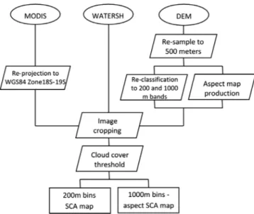
Given the study area size and the study period, a mas-sive amount of data needed to be analyzed. Therefore we divided the area into three zones (i.e. Northern, Central, and Southern, see fig. 1 and tab. 1), to better show our findings. This choice is based on the previous DGA re-port (DGA, 2008), where the same zones were used. We used MODIS data , in particular the MOD10A2-V5 snow product (Hall & alii, 2006), already used in other studies concerning SCA in Chile (e.g. Favier & alii, 2009; Sther & alii, 2009). Data can be downloaded from the National Snow and Ice Data Center website (NSIDC, nsidc.org). The dataset contains information of maximum snow cov-er extent in an eight-day pcov-eriod (bundle), with 500 metcov-ers of resolution. We also used the DEM from the Shuttle Radar Topography Mission (SRTM90, see www2.jpl.nasa. gov/srtm), which features a resolution of 90 meters, to depict topography. The same MODIS sensor and DEM were used in the previous DGA report (DGA, 2008).
The MODIS scenes were first re-projected from the original sinusoidal format to the WGS84 Datum (Zones 19S and 18S). Then, the DEM was resampled to match the MODIS resolution. The MODIS images and the DEM were subsequently cropped to fit the area of the watersheds studied here. In this phase, we used the catchments’ template provided by the Dirección General de Aguas (DGA) in the form of polygonal shapefiles as a basis for clipping.
A pre-processing phase consisted in the selection of the images with low cloud coverage, necessary to attain unbi-ased SCA analysis. A threshold of 30% was set for cloud cover, to ensure the best tradeoff between image quality and number of scenes available for the analysis. So do-ing, only 2% of the data was discarded. The choice of this threshold was largely influenced by the high presence of cloud cover over the Bueno basin, where clouds were more frequent than all the other watersheds. Other studies (e.g. Gafurov & Bàrdossy, 2009; Paudel & Andersen, 2011), developed an algorithm to remove cloud noise from the MODIS products. This was not necessary here because, being the MOD10A2 product a bundle of eight-day, the cloud coverage is much lower compared to the daily prod-uct, as a pixel needs to be cloud obscured for 8 days to be flagged as cloud. This makes this product preferable to the MOD10A1 daily product (Wang & alii, 2007), and does not require additional cloud correction to be used.
Further on, the DEM was reclassified into altitude belts of 200 meters to analyze SCA hypsography. As-signment of snow data to each watershed in the altitude belts was performed combining a script written in Py-thon (pyPy-thon.org), and a Geographic Information System (GIS). Altitudes below 400 meters were excluded from the analysis, because no solid precipitation is expected here (DGA, 2008).
Finally, the study of the SCA divided per aspect and 1000 m altitude bins was performed by means of another reclassification of the DEM, and the aspect map derived from it. The workflow is summarized in figure 2.
RESULTS AND DISCUSSIONS
Figure 3 shows the summary results of the SCA analy-sis for all the three zones. Snow ablation starts in Septem-ber, then SCA minima are reached in December in all the zones, while the maximum values are reached in July (i.e. at the end of the austral winter).
The Central zone has much higher values of SCA than the other zones. On the one hand, this is because the Central zone is the largest one (tab. 1). On the other hand, the low topography of the Southern zone and the drier climate towards the north are two major causes of this difference.
In figure 4 we report the SCA distribution per aspect (45° bins) and altitude (1000 m bins). Most of the snow cover shows prevalently westward aspects in all zones, both in Winter and Summer. The reason of such distribu-tion is not straightforward. On the one hand, the North-ern zone shows the most heterogeneous distribution of snow per aspect. Here the presence of glaciers and the plateau makes the recognition of a predominant orien-tation of snow difficult to be interpreted. In the Elqui and Choapa watersheds snow accumulates and persists more westwards due to the presence of transverse ridges (DGA, 2008). On the other hand, the other zones show much smaller variation of the distribution of snow per aspect, especially during winter. In summer, when snow melts, it tends to persist more on south aspects, due to the minor solar radiation received in the austral hemisphere.
Most of the snow of the Central and Southern zones is found in the 2000–3000 m a.s.l. belt in Winter (when SCA is at its maximum). In the same season, in the Northern zone the belt where most of the snow is found is 3000–4000 m a.s.l., higher than in the other zones, due to the presence of the plateau.
NORTHERN ZONE
The Northern zone shows highest variability of month-ly SCA amongst the considered years. Snow cover ranges from the maxima of the winter season, up to 18,244 km2
(in 2007–2008 hydrological year), to as little as 25 km2 in
Summer 2009. The percentage of snow cover over the en-tire zone at maximum snow extent is the lowest of the three considered zones (<30%). In general, SCA decreased dur-ing the four years here considered, and the maximum is always reached in July.
In the southernmost watersheds of this zone (i.e. Lima-rí, Choapa, Petorca, and Ligua basins), no snow is found in our analysis since the end of November until the begin-ning of the next hydrological year (in April). DGA (2008) depicts the same situation during 2000–2007. This is prob-ably due to the less frequent precipitation than the other zones, and because the altitude is lower than the other wa-tersheds of the same zone, thus consisting in the melt of all the snow accumulated during Winter.
CENTRAL ZONE
SCA variability is almost constant in the Central zone during 2008–2011. Maximum values are much higher than the other zones (up to 29,106 km2 in 2010 July), because i)
this is the widest zone (tab. 1), ii) precipitation are higher than the Northern zone, and iii) maximum elevations are on average much higher than the Southern zone, thus facilitat-ing snow accumulation. Glaciers are abundant in this zone. Ablation rates are less evident than the Northern zone, and the accumulation season extends to mid-September. This is in accordance with the previous DGA report (DGA, 2008). In general, SCA decreases through years during the study period, with the hydrological year 2010–2011 showing 10% less SCA than in 2008–2009. A decrease in precipitation (al-though not significant), was observed during 1970–2004 by Pellicciotti & alii. (2007) in the Aconcagua region and this might have caused a decrease in the snow cover in the same decades. Nevertheless, SCA values during 2008–2011 are higher than 2000–2007 on average (data from DGA, 2008).
Northern Zone
(26°S–33°S) Central Zone(33°S–38°S) Southern Zone(38°S–41°S) 1. Copiapó [18704] 8. Aconcagua [7334] 14. Bío Bío [24371] 2. Huasco [9814] 9. Maipo [15274] 15. Imperial [12669] 3. Elqui [9826] 10. Rapel [13767] 16. Toltén [8449] 4. Limarí [11696] 11. Mataquito [6332] 17. Valdivia [10245] 5. Choapa [7654] 12. Maule [21054] 18. Bueno [15367] 6. Petorca [1988] 13. Itata [11327]
7. Ligua [1980]
TOT zone [61662] [75088] [71100]
TOT [207851]
taBLe 1 - The three zones we analyzed, and the respective watersheds (name of the rivers are provided, the numbers are referred to the watershed id
code we assigned in fig. 1). Latitudes (in degrees) and surfaces (in km2, square brackets) are also provide
FiG. 3 - Monthly snow cover
In particular, the maximum value found during 2000–2007 is 5,000 km2, lower than the values found in Winter in our
study period. Finally, maxima are observed between 2200 and 2600 m a.s.l. in July, while snow is still found even in the warmer season at the highest altitudes (>4000 m a.s.l., with the maximum represented by the Aconcagua, the highest peak of the Southern Hemisphere with its 6960 m a.s.l.). Note that only the Aconcagua, Maipo, and Rapel water-sheds are higher than 4000 m a.s.l..
SOUTHERN ZONE
The annual variability of SCA during 2008–2011 is very high in the Southern zone. Maximum values are found since June to August, depending on the hydrological year. Also, SCA decreases on average during 2008-2010, only to in-crease in 2011. Thaw season begins in September as also reported in the previous DGA report (DGA, 2008), for
the period 2000–2007, with high rates leading to minimum cover already in November. The observed maximum value is 21,843 km2 in August 2007. In general, the relatively low
elevations limit snow accumulation here (elevation is often lower than 3000 m a.s.l.). However, precipitation is abun-dant (especially towards the coasts), and snow is found even below 3000 m. Unfortunately, we could not make a compar-ison with the previous DGA report, because the SCA analy-sis during 2000–2007 was made impossible by the massive presence of clouds in this zone. The use of the bundled (8-days) MODIS product against the daily product used in the previous report (MOD10A2 versus MOD10A1), allowed us to have a good dataset for this zone where precipitation (and thus clouds) is frequent throughout the year. As our study period is too short for assessing if SCA variation was significant, we refer to Bown & Rivera (2007), who stud-ied the climate changes during the second half of the 20th century in the Chilean Lake District (38°S–42°S, about the same latitudinal range of the Southern zone). The regional
FiG. 4 - Aspect frequency distribution. It is reported
the percentage of SCA as per aspect (45° bins) and 1000 m altitude belts averaged on 2008–2011 in Win-ter (July, left), and Summer (November, right) in the
rainfall data they collected from 1961 to 2000 showed an overall decrease with a maximum rate of −15 mm/year at Valdivia station (39°38′S/73°05′W). They speculated that this reduction in precipitation might be related to El Niño– Southern Oscillation (ENSO) phenomena which have been more frequent after 1976.
CONCLUSIONS
The present contribution aimed at showing SCA vari-ability during 2008–2011 in the Central Chile, over 18 mountainous watersheds (205,000 km2). MODIS snow
products from the NDSIC were used for the analysis. The dataset (consisting of eight-day bundles of maximum snow cover) was processed combining GIS tools and the Python programming language to automate the production of snow cover maps. We showed that SCA decreased during the four considered years. This is true also looking at a longer time window (i.e. since 2000), according to the previous DGA re-port (DGA, 2008), except for the Central zone, where SCA was higher in 2008–2011. The maximum SCA was found in the Central Zone, while the topographic and climatic fea-tures (i.e. lower altitudes in the South, and a drier climate in the North) limited snow deposition elsewhere. The snow line is higher in the Northern zone due to the presence of the plateau, and it decreases southwards. In the Northern Zone the minimum SCA is reached sooner than elsewhere, and lasts for a longer period (November to March), proba-bly because the drier climate. West apects showed the maxi-mum of SCA in all zones throughout the study period. In the present work we showed how the MOD10A2 product can be used for studying snow covered areas over an ex-tended domain. The spatial (500 m) and temporal (weekly) resolution of the MODIS sensor, its many bands (36 chan-nels), and the availability of the data at no cost, makes it a reliable product to study SCA where few in-situ measure-ments are available.
REFERENCES
BoWn F. & rivera a. (2007) - Climate changes and recent glacier
behav-iour in the Chilean lake District. Global and Planetary Change, 59, 79–86.
dGa, direCCión GeneraL de aGUaS (2008) - Dinámica de la cobertura
nival entre las cuencas de los ríos Copiapó y Petrohue utilizando imá-genes satelitales. Dirección General de Aguas, Unidad de Glaciología y Nieves, Santiago de Chile.
Favier v., FaLvey M., raBateL a., Praderio e. & LòPez d. (2009) -
In-terpreting discrepancies between discharge and precipitation in high-altitude area of Chile’s Norte Chico region (26–32°S). Water Resources Research, 45, W0242, doi: 10.1029/2008WR006802.
GaFUrov a. & BárdoSSy a. (2009) - Cloud removal methodology from
MODIS snow cover product. Hydrology of Earth System Sciences, 13, 1361–1373.
GhanBarPoUr M. r., SaGhaFian B., Saravi M. M. & aBBaSPoUr K. C.
(2007) - Evaluation of spatial and temporal variability of snow cover in a large mountainous basin in Iran. Nordic Hydrology, 38(1), 45–58. Godone d., FiLiPPa G., terzaGo S., riveLLa e., SaLandin a., BarBero
S., Garnero G. & FrePPaz M. (2011) - Snow cover Extent and
Dura-tion in MODIS Time Series: A Comparison with in-sity Measurements (Provincia Verbano Cusio Ossola, NW Italy). International Journal of Environmental Protection, 1 (4), 7-11.
haLL d. K., SaLoMonSon v. v. & riGGS G. a. (2006) - MODIS/Terra Snow
Cover 8-Day L3 Global 500m Grid. Version 5. [Jan-Dec, 2001-2010]. Boulder, Colorado USA: National Snow and Ice Data Center.
MiLLer a. (1976) - The climate of Chile. In: W. Schwerdtfeger (Ed.)“World
Survey of Climatology”, Vol. 12”, 113–145. Elsevier, Amsterdam. PaUdeL K. P. & anderSon P. (2011) - Monitoring snow cover variability
in an agropastoral area in the Trans Himalayan region of Nepal using MODIS data with improved cloud removal methodology. Remote Sens-ing of Environment, 115, 1234–1246.
PeLLiCCiotti F., BUrLando P., & vLiet K. v. (2007) - Recent trends in
pre-cipitation and streamflow in the Aconcagua River Basin, central Chile. IAHS Publ. 318.
Sther a., deBeLS P., arUMi J. L., roMero F. & aLCayaGa h. (2009) -
Com-bining the Soil and Water Assessment Tool (SWAT) and MODIS im-agery to estimate monthly flows in a data-scarce Chilean Andean basin. Hydrological Sciences, 54(6).
verBUnt M., GUrtz J., JaSPer K., LanG h., WarMerdaM P. & zaPPa M.
(2003) - The hydrological role of snow and glaciers in alpine river basins and their distributed modeling. Journal of Hydrology, 282, 36–55.