eum
Studies on the Value of Cultural Heritage
JOURNAL OF THE SECTION OF CULTURAL HERITAGE
University of Macerata
201
5
12
IL CAPITALE CULTURALE
Vol. 12, 2015
ISSN 2039-2362 (online)
© 2015 eum edizioni università di macerata Registrazione al Roc n. 735551 del 14/12/2010
Direttore Massimo Montella Coordinatore editoriale Mara Cerquetti Coordinatore tecnico Pierluigi Feliciati Comitato editoriale
Alessio Cavicchi, Mara Cerquetti, Francesca Coltrinari, Pierluigi Feliciati, Valeria Merola, Umberto Moscatelli, Enrico Nicosia, Francesco Pirani, Mauro Saracco
Comitato scientifi co – Sezione di beni culturali
Giuseppe Capriotti, Mara Cerquetti, Francesca Coltrinari, Patrizia Dragoni, Pierluigi Feliciati, Maria Teresa Gigliozzi, Valeria Merola, Susanne Adina Meyer, Massimo Montella, Umberto Moscatelli, Sabina Pavone, Francesco Pirani, Mauro Saracco, Michela Scolaro, Emanuela Stortoni, Federico Valacchi, Carmen Vitale
Comitato scientifi co
Michela Addis, Tommy D. Andersson, Alberto Mario Banti, Carla Barbati, Sergio Barile, Nadia Barrella, Marisa Borraccini, Rossella Caffo, Ileana Chirassi Colombo, Rosanna Cioffi , Caterina Cirelli, Alan Clarke, Claudine Cohen, Lucia Corrain, Giuseppe Cruciani, Girolamo Cusimano, Fiorella Dallari, Stefano Della Torre, Maria del Mar Gonzalez Chacon, Maurizio De Vita, Michela Di Macco, Fabio Donato, Rolando Dondarini, Andrea Emiliani, Gaetano Maria Golinelli, Xavier Greffe, Alberto Grohmann, Susan Hazan, Joel Heuillon, Emanuele Invernizzi, Lutz Klinkhammer, Federico Marazzi, Fabio Mariano, Aldo M. Morace, Raffaella Morselli, Olena Motuzenko,
Angelo R. Pupino, Bernardino Quattrociocchi, Mauro Renna, Orietta Rossi Pinelli, Roberto Sani, Girolamo Sciullo, Mislav Simunic, Simonetta Stopponi, Michele Tamma, Frank Vermeulen, Stefano Vitali
Web
http://riviste.unimc.it/index.php/cap-cult
Editore
eum edizioni università di macerata, Centro direzionale, via Carducci 63/a – 62100 Macerata tel (39) 733 258 6081 fax (39) 733 258 6086 http://eum.unimc.it [email protected] Layout editor Cinzia De Santis Progetto grafi co
+crocevia / studio grafi co
Rivista riconosciuta CUNSTA Rivista accreditata AIDEA Rivista riconosciuta SISMED
Archeologia delle aree montane
europee: metodi, problemi e casi di
studio
Archaeology of Europe’s mountain
areas: methods, problems and case
studies
565
http://riviste.unimc.it/index.php/cap-cult © 2015 eum
Basque Cultural Landscapes of the
Western French Pyrenees
* Ted L Gragson, Professor of Anthropology, University of Georgia & IdEx Chair, Laboratoire
TRACES – Université de Toulouse – Jean Jaurès 250A Baldwin Hall 355 S Jackson Street, Athens, GA 30602-5003, e-mail: [email protected].
** David S. Leigh, Professor of Geography, University of Georgia Geography-Geology Bldg.
210 Field Street, Athens, GA 30602-5026, e-mail: [email protected].
*** Michael R. Coughlan, Postdoctoral Fellow, University of Georgia 250A Baldwin Hall 355
S Jackson Street, Athens, GA 30602-5003, e-mail: [email protected].
Ted L Gragson*, David S. Leigh**,
Michael R. Coughlan***
Abstract
Results are presented on the co-evolution of agropastoralism and soils in the western Pyrenees Mountains (>800 masl) over the course of the Holocene conducted in the ethnically Basque commune of Larrau, France. Larrau presents a unique opportunity to examine the structural legacies and biotic factor in soil evolution across millennia. Multi-proxy evidence from geoarchives, archaeology, history and ethnography is analyzed to evaluate the relation between land management practices, soil characteristics and chronostratigraphy in the study
area. Research indicates that the landscape of Larrau has been subject to intense human transformation through agropastoral use since at least the early Bronze age, yet there are no signs of signifi cant degradation of the soil mantle. The place-based approach followed in this research provides the means for evaluating modal human behaviors and decision-making within a complex adaptive system. It details how the present is connected to the past and how contemporary land systems can contribute to a sustainable future.
Nel corso della ricerca effettuata nel comune etnicamente basco di Larrau (Francia) abbiamo indagato tracce multi-proxy per esaminare le forme di domesticazione dei paesaggi montani (> 800 m slm) dei Pirenei occidentali, nel corso dell’Olocene. I nostri dati suggeriscono che in quest’area le foreste originarie sono state trasformate in pascoli diverse migliaia di anni fa, senza che questo abbia comportato un degrado signifi cativo del paesaggio e dei suoli. Il patrimonio dei paesaggi agropastorali di Larrau offre una rara opportunità per esaminare un doppio sistema in lento cambiamento, nel quale, attraverso millenni, le attività di gestione umana hanno strutturato un paesaggio scenografi co, creando un sistema di produzione agropastorale resiliente e durevole, e hanno reindirizzato i sottostanti percorsi e meccanismi di pedogenesi. Se i sistemi terrestri contemporanei mirano a raggiungere un desiderabile futuro sostenibile, la situazione attuale deve essere continuamente e fortemente collegata al suo passato.
Introduction
The prime-mover explanations once favored for the expansion of domestication in Europe1 are yielding to evidence that the Neolithic transition
involved elements of demic diffusion, local adoption, and independent domestication2. The change in viewpoint stems from new methods for
determining plant and animal domestication, systematic examination of high-resolution post-depositional environments, and extensive use of chronometric dating3. Such research was initially concentrated in highly evolved,
low-gradient riverine environments4, but the procedures are increasingly used in
high-gradient mountain settings including the Pyrenees5. At the human scale,
agropastoralism subsumes numerous activities that in combination contribute to shaping mountain landscapes over time. Interpreting the human capacity to transform earth processes over the Holocene by reference to a single activity such as grazing using a single fossil archive such as pollen can lead to simplistic
1 Ammerman, Cavalli-Sforza 1984; Dearing 2008. 2 Crubézy et al. 2006; Rowley-Conwy 2011; Zeder 2008.
3 Berger 2011; Dotterweich 2008; Galop et al. 2013; Rowley-Conwy 2011; van Mourik,
Jansen 2013; Zeder 2008.
4 Berger 2011; Dotterweich 2008; Hoffmann et al. 2008; Holliday 1985. 5 Cunill et al. 2012; Ejarque et al. 2010; Kaal et al. 2008.
and deterministic accounts that are no different than earlier prime-mover explanations6.
Agropastoralism is the primary means by which humans modifi ed European mountain landscapes over the course of the Holocene7, but the geomorphic,
topographic, climatic and vegetative heterogeneity of these landscapes means that results obtained in one region may not be valid for interpreting mountain landscapes elsewhere8. More importantly, land degradation may not be the
inevitable consequence of agropastoral practices. Whether such practices set in motion a degradation cycle can only be evaluated by ensuring the resolution of proxy indicators matches the human scale of land use activities9. The scale
most suitable for analyzing human-environment interactions, particularly in mountain areas, is the local10. Accumulating evidence furthermore indicates
that human land use over the Holocene in mountain landscapes was largely decoupled from climatic/temperature gradients11. Therefore adding additional
weight to the need for avoiding simplistic and deterministic physical explanations of human land use in mountain settings12.
Numerous studies confi rm that mountain landscapes are the result of climatic and anthropic pressures exerted and interrelated in a variable manner over the course of the Holocene13. Examining the dynamics of this long-time
series is key to identifying the existence of thresholds, alternative steady states, adaptation, contingency, and feedback in the anthropization of European mountain landscapes. It is equally important to explaining their contemporary biodiversity, landscape fragmentation, and habitat fragility14. Not only is
environmental history relevant to an understanding of the past, it may be equally important to the future protection, management and promotion of the natural and cultural heritage of mountain landscapes.
In light of these observations, we are examining the co-evolution of agropastoralism and soils in the ethnically Basque commune of Larrau (Départment de Pyrénées Atlantiques, France) using multi-proxy evidence from geoarchives, archaeology, history and ethnography. While it complements previous work in the western Pyrenees15 on the agropastoral transformation
of mid-elevation (800-2000 masl) mountain landscapes, our approach is place-based and premised on the idea that factors of change cannot be separated from
6 Cunill et al. 2013; Ejarque et al. 2011; Moe et al. 2007.
7 Bal et al. 2015; Cunill et al. 2013; Ejarque et al. 2011; Moe et al. 2007. 8 Ejarque et al. 2011; Mazier et al. 2009; Brun 2011.
9 McGovern et al. 2007; Sandweiss, Kelley 2012. 10 Davis, Stevenson 2007; Dearing et al. 2010.
11 Cunill et al. 2013; Ejarque et al. 2011; Ejarque et al. 2010. 12 Cunill et al. 2013; Ejarque et al. 2011; Ejarque et al. 2010.
13 Bal et al. 2011; Ejarque et al. 2010; Pelachs et al. 2011; Vannière et al. 2001. 14 Bal et al. 2015.
factors of location, duration and intensity16. Cultural landscapes such as those
in Larrau provide a rare opportunity to examine the origin of structural legacies and isolate the biotic factor in soil evolution over the course of the Holocene17.
Our results are organized to address 1) cultural management practices linked to soil fertility; 2) persistent conversion of forests to pastures leading to distinct chemical and physical soil profi les; and, 3) chronostratigraphy of small watersheds in relation to land clearing, pasture maintenance and reforestation across time. The conjunction of structural (long-cycle) and signal (short-cycle) processes in Larrau links the past to the present and provides the basis for evaluating modal human behaviors that transform earth processes. It also makes it possible to examine the response diversity of human decision-making about desired environmental end-states within a complex adaptive system18. As such,
it clarifi es how the present must be continuously and strongly connected to its past if contemporary land systems are to achieve a desirable and sustainable future.
Background
Methodological, theoretical and conceptual advances are leading to a reassessment of the relation between human land use and pedogenesis. Soils are complex open process-response systems that are continually adjusting by various degrees, scales and rates to changing external and internal forces – all soils have a polygenic origin19. Human agropastoral land use, however, has
often been examined as disrupting the ‘natural equilibrium’ of the soil system by accelerating erosion and degrading soil potential, ultimately leading to the extinction of the society dependent on the soil20. While agropastoral landscapes
are constantly evolving over time and across geographical scales in response to both physical forces as well as human activities, notorious cases such as Easter Island21 are not proof of the inevitable collapse of all human land systems.
There have been numerous expansions and regressions of agricultural activity in Europe over the course of the Holocene22, and the path from onset to the
present is far from linear or deterministic.
From an evolutionary standpoint, the mere endurance of Basque agropastoralism across millennia hints at the existence of positive, not only
16 Russell 1998.
17 Bain et al. 2012; Yaalon 1975; Jenny 1958.
18 Antrop 2005; Leslie, McCabe 2013; Valsecchi et al. 2010; Willis, Birks 2006. 19 Beckman 1984; Johnson, Watson-Stegner 1987.
20 Harris 2012; van Andel et al. 1990. 21 Dearing et al. 2010; Harris 2012. 22 Dotterweich 2013.
negative feedback mechanisms. Slow processes that unfold over decades or centuries such as the evolution of low-country Plaggen soil by manuring to increase nutrient supply and water retention23 or the evolution of stem
families to manage household labor and landesque (i.e., permanent landscape modifi cations through the construction of terraces, lynchets, headlands and fi eld boundaries)24 lie beyond the reach of observational and instrumental data.
The challenge is to understand the options and constraints the world presents people, the choices people make, and how their choices alter the world25. In
effect, there is a need to ground concepts in observations and analyses that are place-based, comparative, and long-duration26.
Our research problem centers on how long-term Basque agropastoralism in the western north-facing Pyrenees redirects pedogenic pathways and products detectable over centennial to millennial timescales. This problem includes factors and processes that interact across geographic space and give rise to a variable soilscape that can be characterized in time yet preserves signatures from its transformation over time as illustrated in the conceptual framework for our research (fi g. 1). Jenny’s27 factorial pedogenic model can explain the
geographical variation of soils in Larrau, Alfi sols (Typic Hapludalfs) under forest and mollic Alfi sols (Mollic Hapludalfs) under pasture. However, our evidence and that of others in the Pyrenees28 indicates that human
forest-to-pasture conversion and manipulation of the organic factor over the Holocene represents human action distinct from the other factors within Jenny’s model (e.g., climate, topography, parent material).
Beyond Jenny’s factors, pedogenesis is also understood as a function of additions, removals, translocations and transformations of materials within soil horizons29. In Larrau, for example, pastured soil profi les lack an eluvial (E)
horizon that many of the forested soils contain. There is thus evidence of both progressive (i.e., up-building of the pastured A horizon) versus regressive (i.e., obliterating original forest A, AB and B horizons) pathways in the soilscape, not merely changes within a soil horizon30. In Larrau, the build-up of organics and
structural improvement in pastured soils exemplify a “progressive pathway” while the loss of forest-soil horizonation exemplifi es a “regressive pathway”. At the scale of a landscape, agropastoral land use involves specifi c activities restricted to particular types of sites, but examined at a moment in time. A resulting problem is disentangling whether certain vegetative species primarily
23 Chiti et al. 2009; Dercon et al. 2005; van Mourik et al. 2011. 24 Arrizabalaga 1997; Kirch 2007; Olsson et al. 2000; Sabean 1990. 25 Smith 2012.
26 Carpenter et al. 2009; Collins et al. 2011; Dearing et al. 2010. 27 Jenny 1941; Jenny 1958.
28 e.g., Ejarque et al. 2011. 29 Simonson 1959.
occur in areas because of their contemporary environmental conditions, because of the activities that humans carry out at these locations in the present, or because of the legacy of past human and non-human disturbances at these locations31.
The agropastoral transformation of the north-facing, western Pyrenees remains poorly documented and has not been subject to the same level of research carried out in the south-facing western Pyrenees or the eastern Pyrenees, north- or south-facing32 Few sites have been excavated, and even fewer have been
published33. There has also been a tendency to focus on monumental remains
(tumuli, stone circles)34 so that little is known about the use of habitat or
resources. Most of what is known about the anthropization and neolithization of the north-facing western Pyrenees is due to the research by Galop and his associates35. The composite Holocene history of the western Pyrenees
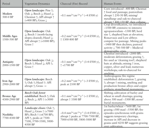
that emerges from their research provides ample evidence that the “natural” vegetation of this region results from the coupling of edaphic conditions in response to climatic oscillations and human agropastoral activities (tab. 1).
The fi rst pollen evidence for agro-pastoral activities in the Basque country dates to the Early Neolithic (7500-7200 cal yr BP)36. Since its occurrence at
elevation predates its appearance in the Lourdes Basin (6800-6500 cal yr BP)37
it has been inferred that domesticates arrived in the Basque country from the Mediterranean basin via the Ebro valley38. Grazing activities extend to the
western Pyrenees during the Middle-to-Late Neolithic (6500-4300 cal yr BP)39
simultaneous with increasing signs of agriculture and human occupation in the piedmont40 and the south-facing slopes of the western Pyrenees41. Fire episodes
are synchronous with the occurrence of Cerealia-type pollen suggesting large, but temporary impacts from burning42.
Although Cerealia-type pollen increases ca. 4100 BP suggesting the growing importance of agriculture, clearings remain small as inferred from the low fi re frequency during the Bronze Age (4300-2300 BP). Increased deforestation is inferred from an increase in API (Anthropogenic Pollen Indicators:
31 Dambrine et al. 2007; Dupouey et al. 2002; Foster, Aber 2004; Hooke 1985; Lemon 1974. 32 e.g., Bal et al. 2011; Bal et al. 2010; Cunill et al. 2012; Ejarque et al. 2011; Lopez Saez et al.
2008; Pérez-Díaz et al. 2015; Vannière et al. 2001.
33 Marticorena 2014. 34 Blot 2014.
35 Carozza et al. 2005; Cugny et al. 2010; Mazier et al. 2009; Monna et al. 2004. 36 Galop 2006.
37 Rielle, Andrieu 1995; Rius et al. 2012.
38 Berger, Guilaine 2009; Peña-Chocarro et al. 2005. 39 Galop 2006.
40 Rius et al. 2009. 41 Pérez-Díaz et al. 2015. 42 Rius et al. 2012.
Plantago, Artemisisa, Asteroideae, Brassicaceae, Centaurea, Chenopodiaceae, Cichoriodeae, Polygonum, Rubiaceae, Rumex, Trifolium, Urtica) ca. 3300
BP, although the use of several of these apophytes for determining human disturbance is increasingly questioned43. The absence of fi re has been interpreted
as the transition from an agro-sylvo pastoral system (e.g., slash-&-burn with forest fallows) to an agropastoral system44 coincident with increased grazing
activity above 500 m.
Regular and frequent fi res characterize the Iron Age (2300-2000 cal yr BP). Along with the increased percentages of Poaceae-type pollen, an abrupt increase in API, and a decrease in arboreal pollen leads to the inference that grazing dominates during this period. There is also a rapid development of mining and smelting activities assumed to be associated with increased deforestation45.
These trends continue into Antiquity (2000-1500 cal yr BP), with Roman and Basque mining activities expanding to include exploitation of iron, copper, silver further driving deforestation46. The low counts of arboreal pollen and
high counts of API, Poacea-type, and nitrophilous taxa suggest relatively open vegetation dominated by herb communities with grasses. It has been suggested that fi res are used as a “cleaning tool”47 during this period.
API remain high and arboreal pollen low during the Middle Ages (1500-500 cal yr BP), with an abrupt drop off in beech (Fagus) after 700 BP. Fire occurrence is regular and high. There is diversifi cation in crops with the addition of rye (Secale) between 1500-1300 cal yr BP48, followed by expansion of cropping
activity between 1300-1100 cal yr BP49. There is further intensifi cation of
agropastoral and mining activities between 1000-800 cal yr BP corresponding to the medieval population boom50. Land intensifi cation have been inferred
from the abrupt drop in arboreal pollen leading to the assumption that the area was extensively deforested between 1500-1000 BP, including the most sheltered north-facing slopes51. Similar patterns have been recorded in the
eastern Pyrenees and elsewhere in Europe52. This was followed by a decrease
in agro-pastoral activities during the Medieval Crisis (700-600 cal yr BP) associated with human demographic collapse53.
Modern (500-0 cal yr BP) is characterized by progressive economic and demographic recovery, with an increase in fi re occurrence (ca. 3.5+ fi res/500
43 e.g., Ejarque et al. 2011. 44 Galop 2006.
45 Monna et al. 2004. 46 Ibidem; Rius et al. 2009. 47 Rius et al. 2009. 48 Galop 2000. 49 Rius et al. 2012. 50 i.e., Bonnassie 1989.
51 Cugny et al. 2010; Mazier et al. 2009; Monna et al. 2004; Rius et al. 2012. 52 Cunill et al. 2013; Valsecchi et al. 2010; Vanniere et al. 2011.
yr). There is a noticeable slump in forest taxa used for charcoal production associated with the intense metalwork production in the 17-18th centuries54
that collapses in the 19th century. Grazing pressure increases AD 1900-2000, but the increasing rural exodus of the 20th century leads to land abandonment and reforestation55.
Socio-Ecological Dynamics in the Western Pyrenees
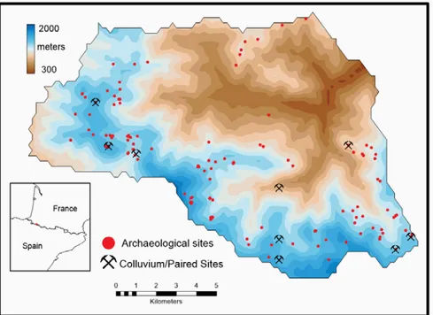
The commune of Larrau is part of Soule, the smallest of the seven Basque Provinces centered on the Saison River in the French department of Pyrénées-Atlantiques. The commune (a town and surrounding land with recognized political and economic authority) of Larrau abuts the Spanish border (fi g. 2) and covers 12,680 ha. During the 1860s, there were over 100 households in Larrau engaged in agropastoralism and a population of ca.1600. Today, the commune has about 25 farming households and a population of ca. 200 residing either in the town of Larrau or one of six low-density neighborhoods (FR: quartier). Agropastoralism remains important economically as well as for reasons of identity.
Larrau residents self-identify as Souletin Basque and speak Souletin which is one of several dialects of Basque, a non-Indo-European language56. While
multiple genetic sources point to the Basque as having locally differentiated within their present territory ca. 18,000 years ago57, much of our understanding
of the Basque and the valleys perpendicular to the axis of the Pyrenees Mountains as oligarchic republics58, including the Soule, post-dates AD 1000. Cohesion in
these republics was achieved by complementary and seasonal use of highland and lowland grazing areas by villages along the length of a valley. Market exchanges took place in a central valley town (i.e., Tardets in Soule), yet were tied to a macroregional exchange network that included piedmont towns north (e.g., Pau) and south (e.g., Pamplona) of the Pyrenees59.
The climate is humid oceanic (i.e., Atlantic) on the north-facing Pyrenees where Larrau is located, with a long-term (AD 1956-2010) mean annual precipitation of ca. 1700 mm and a mean annual temperature ca. 13°C (range: 7-20°C). The area lies fl oristically within the Basque-Cantabrian district of the Cantabrian-Pyrenean sector60, which is a transitional ecotone between the
54 Galop 2001. 55 Galop et al. 2011.
56 Gómez-Ibáñez 1975; Vyerin 2011. 57 Bauduer et al. 2005.
58 Cursent 1998; Gómez-Ibáñez 1975; Lefebvre 1963. 59 Lefèbvre 1933; Zink 1997.
Eurosiberian and the Mediterranean biogeographic regions61. Flora in Soule
at present includes the Pyrenean oak (Quercus pyrenaica) dominates between 300-800 masl and is often associated with pedunculate (Q. robur L.) and sessil oak (Q. sessilifl ora) traditionally pollarded to obtain fi rewood and animal bedding62. These species punctuate the intermediate zone used for rough grazing
that is otherwise characterized by heath (Erica vagans, E. ciliaris, E. cinerea), gorse (Ulex europaeus and U. minor – both tend to diminish above 500 m), bracken (Pteris aquilina), ling (Calluna vulgaris), and broom (Sarothamnus
scoparius).
Between 800-1100 masl, pedunculate oak gives way to beech (Fagus
silvatica) often intermingled with fi r (Abies pectinata) and chestnut (Castanea sp.) fi rst introduced to the area ca. 2000 BP based on pollen and other records63.
Through the middle of the 20th century, nuts from beech and chestnut were used as wild-forage for livestock and to produce fl our for making fl at cakes, while the wood was used to make diverse farm implements. Beech and fi r disappear ca.1550 masl giving way to a “grazing-climax” of grasses that begin to appear ca. 1285 masl64. The most common species in this complex are bentgrass
(Agrostis spp.), fescue (Festuca spp.), nard (Nardus stricta), and bluegrass (Poa
spp.) intermingled with various sedges (Family Cyperaceas) and legumes (e.g., Trifolium alpinum). No trees currently grow above ca. 1700 masl; the natural
treeline, however, would be around 2200-2300 masl and ranged to ca. 2400 masl during portions of the Holocene65.
Methods & Materials
In partnership with French colleagues we have carried out ethnographic, historic and most recently archaeological and geomorphic investigations detailing many aspects of agropastoralism in the upper Soul66. In parallel
with these investigations we developed a database of fi scal land records for the commune from 1830 to the present that contains 1) parcel profi les (e.g., taxable use – plowed fi eld, pasture, etc., taxable value produced by the use, and owner) linked to 2) an ESRI GeoDatabase with polygon and topology values for each parcel and the structural footprints of houses, barns, cabins, mills, canals, roads, etc. We have used Bayesian Weights of Evidence and
61 Nogués-Bravo, Martínez 2004. 62 Fenley 1951; Lefèbvre 1933.
63 Conedera et al. 2004; Huntley et al. 1989; Lindbladh et al. 2008; Pérez-Díaz et al. 2015. 64 Morellón et al. 2012; Ninot et al. 2007.
65 Cunill et al. 2012.
Event History procedures67 to assess parcel use and management by individual
households, predict the location and occurrence of fi re events given spatially explicit evidence layers, as well as the processes of parcel extensifi cation and household abandonment68.
We combined results with aerial photography, contour maps and a preliminary archaeological inventory to guide a systematic pedestrian survey of the commune in 2012, 2013 and 2014. We have so far located and fully described over 100 prehistoric/early historic sites69. The survey has allowed
us to verify and validate ethnographic and archival evidence on parcel-level settlement in addition to locating historic and prehistoric places previously only recorded by lieu-dit (a small geographic area with a traditional name) and in several instances never recorded. Eleven sites were selected to carry out a ground penetrating radar survey, limited subsurface testing using a 10 cm diameter bucket auger and recover datable material to establish the correspondence between surface and buried features70. Two of these sites were excavated in
2014 by French colleagues71.
During the survey we identifi ed four hillslope sites where large pastures occur immediately adjacent to forests with similar bedrock, aspect, and morphology. We excavated fi ve paired soil pits at each site (n=40 profi les) well into the B horizon and in several cases to the contact with bedrock. Genetic soil horizons were described and soil horizons were sampled according to their boundary lines72. Also during the survey we identifi ed colluvial depositional sites on small
fl ats, benches, toeslopes or depressions immediately beneath zero-order hollows located on pastured hillslopes with known histories draining <10 hectares. Sites were selected to maximize the likelihood of spatially uniform and temporally steady slopewash sedimentation. A 7.6 cm diameter bucket auger was used to retrieve a complete stratigraphic column of unconsolidated colluvial sediment in contiguous 10 cm sample increments that were bagged in the fi eld for subsequent laboratory analyses73.
Particle size analysis of all samples followed the hydrometer and sieve method74
using a known volume of soil extracted from the uppermost 7.5 cm of each A horizon. Subsamples were dried, weighed, and weight fractions of gravel, sand, silt, and clay were quantifi ed with respective size breaks at 2000, 63, and 2 μm. Hydrogen icon concentration (pH) of a 1:2 soil-water paste was measured with a Corning® pH meter 443i; plant-available nutrients were determined by the
67 Blossfeld et al. 2007; Link, Barker 2010. 68 Coughlan, Gragson n.d; Coughlan 2013a.
69 Champagne, Le Couédic 2012; Le Couédic, Champagne 2013; Champagne et al. 2015. 70 Gaffney, Gater 2003; Stein 1986; Thompson et al. 2011.
71 Champagne et al. 2015. 72 Soil Survey 1993.
73 Leigh et al. 2015a; Leigh et al. 2015b. 74 Gee, Bauder 1986.
double-acid technique; and dry bulk density was based on the weight of mineral topsoil excluding the O horizon75. Macro-charcoal fragments recovered from
the auger cuttings in the colluvial samples were cleaned and leached of possible carbonates with an acid-alkali-acid pretreatment76 then radiocarbon (14C)
dated by the accelerator mass spectrometry (AMS) method at the University of Georgia’s Center for Applied Isotope Studies. Bulk sediment material was dated following ultrasonic dispersion and sieving through 125 µm mesh then cleaned with 1N HCl to remove possible carbonates. Calendar year calibrations were calculated using CLAM77 based on the IntCal09 calibration curve78; calendar
years before present (cal BP) reference A.D. 1950 as “present”.
Colluvial subsamples were crushed to pass a 1 mm mesh. The resulting material was then placed in 2 cm3 cylindrical plastic containers and their mass-specifi c magnetic susceptibility (χfd) was measured using the low frequency setting on a dual-frequency Bartington™ MS3 magnetic susceptibility meter. Fires with soil temperatures >400 °C can produce signifi cant amounts of secondary magnetic minerals that allow the ascription of sediment to past forest fi res79. In addition,
subsamples of 10-15 g of the <8 mm fraction were gently dispersed in a 100 g/L solution of sodium hexametasphosphate, then wet-sieved to pass a 125 µm mesh. The >125 µm residue (sand + organic matter) was bathed in a 5 percent solution of hydrogen peroxide (to destroy/bleach non-charcoal organics), oven-dried at 105 °C then gently salted into a plastic vial containing liquid sodium polytungstate with a density of 1.75 g cm-3. The fl oating fraction containing charcoal was removed by freezing the sample then rinsing the fl oated surface material on to Whatman #1 fi lter paper using a vacuum fi ltration funnel and fl ask. The residue on the fi lter was photographed at 10 µm pixel resolution, and the area of uniquely black charcoal fragments quantifi ed using Sigma Scan Pro 5. The area of charcoal is normalized to a cubic centimeter based on an average dry bulk density of 1.5 g cm-3. It has been demonstrated80 that charcoal >125
µm derives from local fi res, while charcoal recovered in colluvium from small hollows produces a reliable record of past fi res.
We explored the utility of n-alkane hydrocarbon chains as biomarkers to evaluate the forest-to-pasture conversion81. We used two sample pairs
from the hillslope forest-pasture soil profi les, and one sample each from a presumed forested colluvium and a presumed grassland colluvium. We only considered the shift in the ratio of C31/C27 carbon chains known as suitable
75 Klute 1986; Singer, Janitzky 1986; Soil Survey Laboratory 1992. 76 Kurth et al. 2006.
77 Blaauw 2010. 78 Reimer et al. 2009.
79 Blake et al. 2006; Gedye et al. 2000; Oldfi eld, Crowther 2007. 80 Higuera et al. 2005; Clark, Royall 1995.
for reconstructing shifts in vegetation groups82. A toluene extract of each soil
sample was subjected to analysis by gas chromatography coupled with mass spectrometry. The abundance of the straight chain aliphatic hydrocarbons having 31 and 27 carbon atoms (i.e. C31 and C27) were measured using the selected ion monitoring mode (SIM) of the mass spectrometer, with the C31/ C27 ratio represents the ratio of measured abundance of the two masses.
The detailed presentation on the soil profi les and the correlation with proxy curves and radiocarbon dates are contained in another publication83. It
should be clarifi ed that the dates reported here and originally presented in this other paper84 were obtained using a curve published in 200985, since the 2013
calibration curve86 had not yet been published. While we have not re-run the
dates presented here, we have re-run other dates from comparable sites that we are investigating in the Larrau area that are contained in an article published on line87. We have determined the difference in the dates using the 2009 vs. the
2013 curves are on the order of 0-5 years for the 2-sigma range over the course of the Holocene. This has absolutely no impact on the interpretation of results as presented here. Furthermore, as with any point date, the actual value can vary in function of the number of dates used to calculate the calibration curve so as more dates are used individual pin-point dates are likely to vary as the accuracy of the curve increases.
Results
Management Practices
Private lands are located in fl at, low-lying alluvial plains and used intensively for crop cultivation. Intermediate slopes are a mosaic of private and communal fi elds, woodlands, and grazing pastures from which kindling and timber are harvested. Communal lands are above the intermediate zone (>800 masl) to the high drainage divide with Spain and include the zero-order basins where much of the reported research has taken place. Cadastral and other records indicate that the landscape of Larrau has been organized into private-communal lands across the three noted physiographic zones since at least ca. AD 1200. The organization is furthermore relatively stable – less than 12% of the commune
82 van Mourik, Jansen 2013; Zech et al. 2009. 83 Leigh et al. 2015a.
84 Ibidem.
85 Reimer et al. 2009. 86 Reimer et al. 2013. 87 Leigh et al. 2015b.
surface area changed in use between 1830-200388. During certain periods
(notably the 12th-13th and 17th-18th centuries), disinherited sons left their natal farm, enclosed a piece of the common in the intermediate zone to grow crops, and turned the family barn into a house thus establishing a new farmstead. Many farms in the intermediate zone today include as part of their name the word “borda” attesting to this infi lling of the landscape.
Herders traditionally occupied the communal lands above 800 masl from mid-May to mid-August residing in dry-stone huts (olha) keeping their sheep in a corral next to the cabin at night89. Communal lands are not open access,
but subdivided into 50 to 500 ha districts with grazing areas, forestland, building ensembles, and use rights for groups of 1 to 12 herders. This place-based institution – called an olhatia in Basque, a contraction of olha (‘cabin’) and altia (‘surroundings’) – typically goes back several hundred years. Each building ensemble within the olhatia has a proper name and minimally contains a cabin and a corral, sheltered hollow or bench for keeping the sheep at night. Building ensembles are located along the elevation gradient and designated the ‘lower’ (BA: pekoa) and the ‘upper’ (BA: gagne) olha. Users traditionally based themselves out of the lower olha at the beginning of the herding season and out of the upper olha later in the season90. The lower olha are often associated with
1 to 2 artifi cial mounds (ca. 12 m3 each) called tertres (FR), while upper olha
are associated with 3 to 20+ such mounds. While many olha are not associated with mounds, our pedestrian survey indicates that when mounds do occur they are geographically linked to olha and olhatia. Their internal structure as revealed by our GPR survey along with evidence collected in the surrounding area indicates they were probably built during a single construction event, but we have not yet carried out a thorough evaluation of them.
Private and communal lands across the commune of Lar rau (and the Pyrenees in general91) have been maintained by fi re for centuries. North-facing slopes
are typically forested below 1285 masl while south-facing slopes and nearly all slopes above 1400 masl have been cleared of forest and serve as summer grazing lands. While most pastureland is communally owned, households carry the responsibility to appropriately manage the lands they use and this includes pasture burning. Olhatia members burn their olha territory by dividing the territory amongst them to more effi ciently place ignitions across the landscape. Observation, interview, and survey results92 indicate that pastures are burned
annually, although herders recognize that altitude, aspect, exposure, vegetation type, and grazing pressure contribute to variability in fi re frequency. Most respondents state that pastures would become unsuitable for grazing after
88 Coughlan 2013b.
89 Lassure 2006 [1993]; Ott 1993.
90 Lassure 2006 [1993]; Ott 1993; Welch-Devine 2008. 91 Métailié 1981.
three to fi ve years without fi re due to the encroachment of woody vegetation, and that a fi re free interval between 20 to 100 years would be problematic for grazing. For this reason, most pastures are regularly burned at present even if not currently in use. Fire return intervals for burned parcels vary by location, but below 1400 masl they are effectively <5 years.
Fires are set between the months of January and May. While winter weather in the western Pyrenees is typically cool and humid with frequent fog, light rain, and snow at higher elevations dry, southerly, downslope winds periodically bring clear, sunny skies with low humidity. Three to 10 days of such low-humidity days are ideal for setting a fi re as long as low wind speeds prevail. Herders understand fuel moisture thresholds to contain their fi res in pastures, and time the burn so that fi res do not spread to hay meadows, hedgerows, or forests. Informants furthermore state that after 10 days of drying, fi res could burn too hot or escape. Fire management thus consists of constraining fi re by relying on higher fuel moistures in non-pasture vegetation, allowing streams, ridgelines, and livestock trails to function as fi rebreaks, and when necessary setting additional ignitions to both back-burn as well as facilitate spread of fi re to additional pastureland.
Soil Profi le Evolution
The uppermost colluvial stratigraphic unit at all sites is a yellowish-brown (10YR 5/5) to light olive-brown (2.5Y 5/4) non-calcareous silt loam to silty clay loam that can reach a depth of ca. 3 m. Slight pedogenic alteration features are apparent throughout the upper unit, but there is no evidence of buried topsoils or other indicators of episodic sedimentation93. The most signifi cant difference
observed between the pastured versus forested soil is the bulk density of the mineral soil surface, with a mean value of 0.66 g cm-3 for pastures versus 0.93 g cm-3 for forests (bulk density of pastures was less than forests in 19 out of 20 cases). Organic matter and total carbon content are not signifi cantly different indicating that structural differences likely explain the contrasts in bulk density. The A horizons in pastures consistently exhibit strong medium to fi ne granular structure, whereas those in forests exhibit moderate medium to coarse subangular blocky structure. Grass rootlets are much fi ner and more abundant than coarse roots in the forested sites.
The average thickness of the whole A horizon (A1+A2+AB) is more than three times in pastures versus forests soils (18.4 vs. 4.7 cm). Even when the E and EB horizons from the forested epipedons are included, the pastured sites still have epipedons that are more than twice as thick as those in the forests (19.5 vs. 9.3 cm). The uppermost A horizon (A1) is also more than twice as
thick in pasture vs. forest soils (12.2 vs. 4.7 cm). It appears that the A horizons of pastures are building up through time due to decreases in bulk density and by melanization of the once forested E and B horizons (pastures no longer exhibit an E horizon). Thus, the forest to pasture conversion results in signifi cant pedogenic reorganization of the soil profi le, which is largely expressed by reduction of bulk density, melanization, and build-up of the A horizons94.
Chronostratigraphy of Landscape Change
Colluvial cores all exhibit distinct zones of charcoal macrofossils in their middle portions that we used to establish a paleoenvironmental chronology. The counts of >125 µm charcoal and magnetic susceptibility from our two best-dated stratigraphic sections to date (Sakia and Vallon Mulhedoy) indicate that limited burning occurred as early as 10,000 cal yr BP, a situation also recorded in the east-central Pyrenees95. Although some authors96 have suggested
such fi res may indicate human activity in the mountains during the earliest Holocene, we have discovered no archaeological remains in the area from this period and other evidence97 indicates environmental and edaphic conditions at
the beginning of the Holocene may have favored more natural fi res than during the late Pleistocene.
Our magnetic susceptibility and charcoal volume (mm3/kg) results further indicate that the forest-to-pasture transition occurred ca. 4000 to 3200 cal yr BP. There is considerable evidence this period was characterized by relatively wet conditions poorly suited to natural fi res at least in central Europe98 a condition
that is locally indicated by the infl ux of beech (Fagus)99. While we have not yet
identifi ed any habitation sites from this period, the concentration of tumuli and stone circles in saddles and overlooks in Larrau exhaustively inventoried by Blot100 indicates human activity in the zone. The dates for these sites lie between
3200-2000 BP, with the greatest number (92%) dating between ca. 3000-2500 BP. We furthermore determined that the sedimentation rates from sampled colluvial hollows at least doubled after the onset of widespread burning at these sites. Four of our fi ve post-4k BP rates fall within a 0.01 to 1.00 mm/yr range, and our highest rate is 1.01 mm/yr. Finally, the n-alkane C31/C27 ratio for the A horizon of the two modern forest samples was 0.14 and 0.19, while that of two modern pasture samples was 0.05 and 0.04. A sample from above the
94 Ibidem.
95 Cunill et al. 2013. 96 Riera, Turu 2011. 97 Cunill et al. 2013. 98 Dotterweich 2008.
99 Pérez-Díaz et al. 2015; Rius et al. 2009. 100 Blot 2014.
fi rst incidence of intense burning (40-50 cm) presumed to be grassland yielded a C31/C27 ratio of 0.11, while the sample from below the fi rst incidence of intense burning yielded a C31/C27 ratio of 0.68 (130-140 cm)101.
Discussion
The stem family (BA: etxe, FR: famille souche) household has been the fundamental decision-making unit in the Pyrenees Mountains for farm-level production since at least the medieval period102. Individual households were
structurally linked to other houses through institutionalized commodity and non-commodity relations103. The boundaries between households were
permeable and continually changing as people and property were redistributed between them104. However, the household also involved the day-to-day
ordering of power relations within the family – oligarchy was the organizing principal for valleys in the western Pyrenees as well as households. The eldest child (male or female) inherited the entire estate along with the right to form a family, while younger siblings who remained with the house were subject to the decisions and labor demands of the inheritor105. The land estate of individual
houses consisted of numerous private parcels widely distributed across low and intermediate zones of the commune. For example, the Arbide neighborhood in Larrau contained 40 households that in 1830 owned a total of 769 land parcels or an estate of ca. 19 parcels/household106.
The stem family grew out of the need to maintain the integrity across time (i.e., impartibility) of a family’s estate, most notably land and buildings107.
Membership in a household was not only the basis for management practices on private lands it was also the basis for usufruct rights to communal lands and the management practices occurring on them, e.g., the olhatia108. The parcel
is a persistent atomic unit of analysis discernible in historic documents and detectable from physical evidence on the ground that provides a fundamental behavioral unit for managing scale in this coupled human-natural system. The division of the Larrau landscape into private and communal lands is thus the nexus between the scalar organization of society into households, neighborhoods and commune, and the discrete management practices at particular kinds of
101 Leigh et al. 2015a.
102 Cursent 1998; Lefèbvre 1933; Zink 1997; Le Play 1871. 103 Fauve-Chamoux 1984; Ott 1993; Sabean 1990. 104 Cursent 1998; Jenkins 2010; Sabean 1990. 105 Arrizabalaga 2005; Gómez-Ibáñez 1975. 106 Coughlan 2013b.
107 Arrizabalaga 1997; Olsson et al. 2000; Sabean 1990. 108 Cavaillès 1931; Gómez-Ibáñez 1975; Ott 1993.
sites capable of infl uencing and directing pedogenic processes.
It is currently unknown when this characteristic organization of valleys across the Pyrenees into oligarchic republics was established, although some authors109 argue for an ancestry far beyond any records to substantiate its
existence. The earliest historic record for Larrau110 describes how in June 1174
Arnaud de Laginge, his wife Marie Bertrande, his sons Guillaume Arnaud and Raimond gifted to Gerar, Abbot of Sauvelade, the place of Saint Jean Baptiste de Larrau to serve as a monastic church (prieuré). Signifi cantly, the gift included the right to graze (paître) animals on the surrounding lands. In addition to the value of the territory for pasturage, it had strategic value in giving the Abbey of Sauvelade control over the crossing of the Pyrenees at the Port of Larrau, as well as access to routes into Navarra and various destinations (i.e., Pamplona, Isaba, Jaca, Huesca and Saragosa) for sale of merchandise. Saint Jean Baptiste de Larrau also served as a monastic guesthouse (prieuré-hôpital) for pilgrims111.
Our results clearly indicate that the pastured soil profi les have been building up organic matter and enhancing the structural quality of their epipedons for at least hundreds of years. The net effect is creation of a new soil profi le that has signifi cantly better hydraulic properties, and is able to infi ltrate and store more water than native forest soils. This has important implications for certain aspects of watershed hydrology, such as maintaining basefl ow, resisting droughts, and reducing fl ooding. We cannot yet make a direct link between post-AD 1000 practices in Larrau and processes over the last several millennial, but we can state that the human-induced landscape transformation in Larrau from native forest to pasture appear to be benign and in some cases environmentally benefi cial. This contrasts sharply with the stereotypical view that degradation of landscapes is the inevitable outcome of human use, pastoral or otherwise112.
While sedimentation rates double in colluvial hollows after the onset of widespread burning, they remain modest by comparison to Holocene background erosion and sedimentation levels in forested environments. Terminal Pleistocene and early Holocene sedimentation rates calculated from a forested zero-order hollow in southwestern Germany range between 0.30 and 0.60 mm/ yr113. Prehistoric sedimentation rates calculated in zero-order hollows in the
humid-temperate Southern Blue Ridge Mountains (southeastern U.S.A) average 0.23 mm/yr and range from 0.06 to 0.70 mm/yr114, while colluvial footslope
sedimentation rates range from 0.02 to 1.14 mm/yr, and average 0.41 mm/yr115.
For comparison, historic (beginning ca. AD 1820) colluvial sedimentation rates
109 Vyerin 2011. 110 Besse 1910; Steunou 2008. 111 Urrutibéhéty 1982. 112 Otterman 1974; Goudie 2013. 113 Dotterweich 2013. 114 Hales et al. 2012 115 Leigh, Webb 2006.
in the same region range from 2.0 to 2.7 mm/yr and directly attributable to timber harvesting and road construction. It is thus reasonable to conclude that rates measured in Larrau fall within the two-order-of-magnitude range of 0.01 to 1.00 mm/yr recorded for “natural” rates of forested hillslope sedimentation without signifi cant human impact. This slight increase in erosion rates may nevertheless represent the earliest recorded “legacy sediment”116.
Conclusion
The pedosphere has been suggested as the “golden spike” for determining the onset of when human impact on the total environment surpassed natural forces117. Smith and Zeder118 specifi cally suggest that the introduction of
agriculture marks the beginning of the Anthropocene epoch119. The singular
focus on the onset of agropastoralism, however, cannot match the insight into causal processes afforded by a place-based approach to the study of humans in relation to their biophysical environment. How systems progress and regress, how feedbacks link fast and slow processes, and how alternate steady states can co-exist are key elements to the sustainable management of human-dominated ecosystems. They are also central to understanding how agropastoralism in the north-facing western Pyrenees Mountains has shaped the present landscape and soils.
Mountains are increasingly viewed as the “backbone of Europe”120 because
they provision essential ecosystem goods and services to both mountain dwellers and those people living beyond them. The capacity of mountain ecosystems to provide these goods and services, however, is at risk from several sources and in particular the marginalization of agropastoral activities121. The visible
expression of marginalization across Europe, including the north- and south-facing Pyrenees, is the emigration of economically active segments of society and the aging of the local population. This demographic shift has been abetted over the last two centuries by increasingly specialized land-use policies and sectoral regulations122. For example, pastoral fi re use in France is interpreted
by governing bodies and the general public as irresponsible land stewardship that inevitably leads to land degradation.
Our fi ndings demonstrate that use of mountain pastures in Larrau over
116 James 2013.
117 Certini, Scalenghe 2011. 118 Smith, Zeder 2013.
119 Autin, Holbrook 2012; Zalasiewicz et al. 2010. 120 Hazeu et al. 2010.
121 Huber et al. 2013; Rounsevell et al. 2006; Welch-Devine 2008. 122 Cash et al. 2006; Eichhorn et al. 2006; MacDonald et al. 2000.
millennia including the regular application of fi re has not resulted in obvious signs of land degradation. Indirect human agency in Larrau have altered pedogenic processes over the course of millennia, and the transformative processes are not limited to mechanical alterations and direct additions to soil. They include redirecting the pedogenic pathways and processes that sustain soil evolution123.
Pasture-woodlands across Europe are highly valued landscapes – socially, economically, and biotically – although evidence increasingly indicates these “human-made” or cultural landscapes rapidly degrade once agropastoral use and management cease124. Research into the co-evolution of agropastoralism
and soils in the western Pyrenees connects the present continuously and strongly to its past, and this information is necessary if we are to engage contemporary land systems and leverage knowledge and practice across multiple scales to achieve a more desirable and sustainable future125.
References / Riferimenti bibliografi ci
Ammerman A.J., Cavalli-Sforza L.L. (1984), The Neolithic Transition and
the Genetics of Populations in Europe, Princeton, NJ: Princeton University
Press.
Antrop M. (2005), Why landscapes of the past are important for the future, «Landscape and Urban Planning», 70, pp. 21-34.
Arrizabalaga M.-P. (1997), The stem family in the French Basque country: Sare
in the nineteenth century, «Journal of Family History», 22, pp. 50-69.
Arrizabalaga M.-P. (2005), Succession strategies in the Pyrenees in the 19th
century: The Basque case, «The History of the Family», 10, pp. 271-292.
Autin W.J., Holbrook J.M. (2012), Is the Anthropocene an issue of stratigraphy
or Pop Culture?, «GSA Today», 22, pp. 60-61.
Bain D.J., Green M.B., Campbell J.l., Chamblee J.F., Chaoka S., Fraterrigo J.M., Kausahl S.S., Martin S.I., Jordan T.E., Parolari A.J., Sobczak W.V., Weller D.E., Wolheim W.M., Boose E.R., Duncan J.M., Gettel G.M., Hall B.R., Kumar P., Thompson J.M., Vose J.M., Elliott E.M., Leigh D.S. (2012),
Legacy Effects in Material Flux: Structural Catchment Changes Predate Long-Term Studies, «BioScience», 62, n. 6, pp. 575-584.
Bal M.-C., Allée P., Liard M. (2015), The origins of a Nardus stricta grassland
through soil charcoal analyses: Reconstructing the history of a mountain cultural landscape (Mont Lozère, France) since the Neolithic, «Quaternary
International», 366, pp. 3-14.
123 Johnson, Watson-Stegner 1987; Runge 1973; Simonson 1959. 124 Eichhorn et al. 2006; Mottet et al. 2006; Rounsevell et al. 2006. 125 Antrop 2005; Brand et al. 2013; Cash et al. 2006; Dearing et al. 2010.
Bal M.-C., Pelachs A., Pé rez-Obiol R., Julià R.n., Cunill R. (2011), Fire
history and human activities during the last 3300 cal yr BP in Spain’s Central Pyrenees: The case of the Estany de Burg, «Palaeogeography,
Palaeoclimatology, Palaeoecology», 300, n. 1-4, pp. 179-190.
Bal M.-C., Rendu C., Ruas M.-P., Campmajo P. (2010), Paleosol charcoal:
Reconstructing vegetation history in relation to agro-pastoral activities since the Neolithic. A case study in the Eastern French Pyrenees, «Journal of
Archaeological Science», 37, n. 8, pp. 1785-1797.
Bauduer F., Feingold J., Lacombe D. (2005), The Basques: Review of population
genetics and Mendelian disorders, «Human Biology», 77, n. 5, pp. 619-637.
Beckman G.G. (1984), The place of “genesis” in the classifi cation of soils, « Australian Journal of Soil Research», 22, pp. 1-14.
Berger J.-F. (2011), Hydrological and post-depositional impacts on the
distribution of Holocene archaeological sites: The case of the Holocene middle Rhône River basin, France, «Geomorphology», 129, n. 3-4, pp.
167-182.
Berger J.-F., Guilaine J. (2009), The 8200 cal BP abrupt environmental change
and the Neolithic transition: A Mediterranean perspective, «Quaternary
International», 200, n. 1-2, pp. 31-49.
Berthe M. (1984), Famine et épidemie dans les campagnes navaraisses à la fi n
du Moyen Age, Paris: SFIED.
Besse J.-M. (1910), Provinces ecclésiastiques d’Auch et de Bordeaux, Paris: Librairie V Ch. Poussielgue.
Blaauw M. (2010), Methods and code for ‘classical’ age-modelling of radiocarbon
sequences, «Quarternary Geochronology», 5, n. 5, pp. 512-518.
Blake W.H., Wallbringk P.J., Doerr S.H., Shakesby R.A., Humphreys G.S. (2006), Magnetic enhancement in wildfi re-affected soil and its potential for
sediment-source ascription, «Earth Surface Processes and Landforms», 31,
pp. 249–264.
Blossfeld H.-P., Golch K., Rohwer G. (2007), Event History Analysis with
Stata, New York: Psychology Press.
Blot J. (2014), Les tumulus-cromlechs de Millagate (Miragarate) IV et V a
larrau (Pyré né es-Atlantiques),
<http://jacquesblot.over-blog.com/article-les-tumulus-cromlechs-de-millagate-119060021.html>.
Bonnassie P. (1989), La croissance agricole du haut Moyen Âge dans la Gaule
du midi et le nord-est de la péninsule ibérique, in La croissance agricole du Haut Moyen Âge. Chronologie, modalités, géographie, sous la direction du
R. Viader, S. Lavaud, Toulouse: Presses Universitaires du Midi (Flaran 10), pp. 13-35.
Brand F.S., Seidl R., Balo Le Q., Brändle J.M., Werner Scholz R. (2013),
Constructing consistent multi scale scenarios by transdisciplinary processes: The case of mountain regions facing global change, «Ecology and Society»,
Brun C. (2011), Anthropogenic indicators in pollen diagrams in eastern France:
A critical review, «Vegetation History & Archaeobotany», 20, pp. 135-142.
Carozza L., Galop D., Marembert F., Monna F. (2005), Quel statut pour
les espaces de montagne durant l’â ge du Bronze? Regards croisé s sur les approches socié té -environnement dans les Pyré né es occidentales,
«Documents d’Arché ologie mé ridionale», 28, pp. 7-23.
Carpenter S.R., Mooney H.A., Agard J., Capistrano D., DeFries R.S., Díaz S., Dietz T., Duraiappah A.K., Oteng-Yeboah A., Pereira H.M., Perrings C., Reid W.V., Sarukhan J., Scholes R.J., Whyte A. (2009), Science for managing
ecosystem services: Beyond the Millennium Ecosystem Assessment, «
PNAS», 106, n. 5, pp. 1305-1312.
Cash D.W., Adger W.N., Berkes F., Garden P., Lebel L., Olsson P., Pritchard L., Young O. (2006), Scale and cross scale dynamics: governance and
information in a multilevel world, «Ecology and Society», 11, pp. 8.
Cavaillès H. (1931), La transhumance pyrénéenne et la circulation des
troupeaux dans les plaines de Gascogne, Paris: Armand Colin.
Certini G., Scalenghe R. (2011), Anthropogenic soils are the golden spikes for
the Anthropocene, «The Holocene», 21, pp. 1269-1274.
Champagne A., Contamine T., Coughlan M., Gragosn T., Haley B.S., Le Couédic M., 2015, Rapport de prospection et sondages Larrau,
Pyrénées-Atlantiques campagne 2014, Université de Pau et des Pays de l’Adour.
Champagne A., Le Couédic M., 2012, Rapport fi nal de prospection. Larrau
(Pyrénées-Atlantiques), Université de Pau et des Pays de l’Adour.
Chiti T., Neubert R.E.M., Janssens I.A., Certini G., Curiel Yuste J., Sirignano C. (2009), Radiocarbon dating reveals different past managements of adjacent
forest soils in the Campine region, Belgium, « Geoderma», n. 149, pp.
137-142.
Clark J.S., Royall P.D. (1995), Particle-size evidence for source areas of charcoal
accumulation in late Holocene sediments of eastern North American lakes,
«Quarternary Research», 43, pp. 80-89.
Collins S.L., Carpenter S.R., Swinton S.M., Orenstein D.E., Childers D.L., Gragson T.L., Grimm N.B., Grove J.M., Harlan S.L., Kaye J.P., Knapp A.K., Kofi nas G.P., Magnuson J.J., McDowell W.H., Melack J.M., Ogden L.A., Robertson G.P., Smith M.D., Whitmer A.C. (2011), An integrated
conceptual framework for long-term social–ecological research, «Frontiers
in Ecology and the Environment», 9, pp. 351-357.
Conedera M., Krebs P., Tinner W., Pradella M., Torriani D. (2004), The
cultivation of Castanea sativa (Mill.) in Europe, from its origin to its diffusion on a continental scale, «Vegetation History and Archaeobotany»,
13, n. 3, pp. 161-179.
Coughlan M. (2013a), Errakina: Pastoral fi re use and landscape memory in the
Basque region of the French Western Pyrenees, «Journal of Ethnobiology»,
Coughlan M.R. (2013b), Fire use, Landscape Transition, and the Socioecological
Strategies of Households in the French Western Pyrenees, [PhD: University
of Georgia.
Coughlan M.R., Gragson T.L. (n.d.), Household abandonment and landscape
transition in the French Pyrenees, Pays Basque, 1830-1958: A parcel level Event-History Analysis, «(under review)».
Crubézy E., Ludes B., Guilaine J. (2006), Génétique et peuplements néolithiques, in Populations Néolithiques et Environnements, sous la direction du J. Guilaine. Paris: Editions Errance, pp. 43-62.
Cugny C., Mazier F., Galop D. (2010), Modern and fossil non-pollen
palynomorphs from the Basque mountains (western Pyrenees, France): the use of coprophilous fungi to reconstruct pastoral activity, «Vegetation
History and Archaeobotany», 19, n. 5-6, pp. 391-408.
Cunill R., Soriano J.-M., Bal M.-C., Pèlachs A., Pérez-Obiol R. (2012), Holocene
treeline changes on the south slope of the Pyrenees: a pedoanthracological analysis, «Vegetation History and Archaeobotany», 21, n. 4-5, pp. 373-384.
Cunill R., Soriano J.M., Bal M.C., Pèlachs A., Rodriguez J.M., Pérez-Obiol R. (2013), Holocene high-altitude vegetation dynamics in the Pyrenees:
A pedoanthracology contribution to an interdisciplinary approach,
«Quaternary International», 289, pp. 60-70.
Cursent B. (1998), Des maisons et des hommes: La Gascogne médiévale (XIe –
XVe siècle, Toulouse: Presses Universitaires du Mirail.
Dambrine E., Dupouey J.L., Laüt L., Humbert L., Thinon M., Beaufi ls T., Richard H. (2007), Present forest biodiversity patterns in France related to
former Roman agriculture, «Ecology», 88, n. 6, pp. 1430-1439.
Davis B.A.S., Stevenson A.C. (2007), The 8.2ka event and Early–Mid Holocene
forests, fi res and fl ooding in the Central Ebro Desert, NE Spain, «Quaternary
Science Reviews», 26, n. 13-14, pp. 1695-1712.
de Bortoli D., Cunchinabe D., Hautefeuille F., Heiniger-Casteret P., Lavergne M.-P., Palu P., 2004, Patrimoine «materiel» et «immateriel»: la famille,
facteur de stabilite et d’evolution des milieu naturels en pays de Soule (Pyrénées-Atlantiques), Université de Pau et des Pays de l’Adour, <https://
halshs.archives-ouvertes.fr/halshs-00785856/document>.
Dearing J.A. (2008), Landscape change and resilience theory: A
palaeoenvironmental assessment from Yunnan, SW China, «The Holocene»,
18, pp. 117-127.
Dearing J.A., Braimoh A.K., Reenberg A., Turner B.L., van der Leeuw S. (2010), Complex land systems: The need for long time perspectives to assess
their future, «Ecology and Society», 15, pp. 21.
Dercon G., Davidson D.A., Dalsgaard K., Simpson I.A., Spek T., Thomas J. (2005), Formation of sandy anthropogenic soils in NW Europe: Identifi cation
Dotterweich M. (2008), The history of soil erosion and fl uvial deposits in
small catchments of central Europe: Deciphering the long-term interaction between humans and the environment – A review, «Geomorphology», 101,
n. 1-2, pp. 192-208.
Dotterweich M. (2013), The history of human-induced soil erosion:
Geomorphic legacies, early descriptions and research, and the development of soil conservation – A global synopsis, «Geomorphology», 201, pp. 1-34.
Dupouey J.L., Dambrine E., Laffi te J.D., Moares C. (2002), Irreversible impact
of past land use on forest soils and biodiversity, «Ecology», 83, n. 11,
pp. 2978-2984.
Eichhorn M.P., Paris P., Herzog F., Incoll L.D., Liagre F., Mantzanas K., Mayus M., Moreno G., Papanastasis V.P., Pilbeam D.J., Pisanelli A., Dupraz C. (2006), Silvoarable systems in Europe: past, present and future prospects, «Agroforestry Systems», 67, pp. 29-50.
Ejarque A., Miras Y., Riera S. (2011), Pollen and non-pollen palynomorph
indicators of vegetation and highland grazing activities obtained from modern surface and dung datasets in the eastern Pyrenees, «Review of
Palaeobotany and Palynology», 167, n. 1-2, pp. 123-139.
Ejarque A., Miras Y., Riera S., Palet J.M., Orengo H.A. (2010), Testing
micro-regional variability in the Holocene shaping of high mountain cultural landscapes: a palaeoenvironmental case-study in the eastern Pyrenees,
«Journal of Archaeological Science», 37, n. 7, pp. 1468-1479.
Fauve-Chamoux A. (1984), Les structures familiales au royaume des
familles-souches: Esparros, «Annales, Histoire, Sciences Sociales», 39, n. 3, pp.
513-528.
Fenley J.M. (1951), Pollarding: Age-old practice permits grazing in Pays Basque
Forests, «Journal of Range Management», 3, n. 4, pp. 316-318.
Foster D.R., Aber J.D. (2004), Forests in Time: The environmental consequences
of 1,000 year of change in New England, New Haven: Yale University Press.
Gaffney C., Gater J. (2003), Revealing the Buried Past: Geophysics for
archaeologists, Stroud UK: Tempus Publishing Ltd.
Galop D. (2000), La croissance médiévale sur le versant nord des Pyrénées à
partir des données palynologiques, in Villages Pyrénéens Morphogenèse d’un habitat de montagne, sous la direction du M. Berthe, B. Cursente. Toulouse:
CNRS/Université de Toulouse-Le Mirail.
Galop D. (2001), Les apports de la palynologie à l’histoire rurale: L’exemple de
la longue durée des activités agro-pastorales pyrénéennes, «Etudes Rurales»,
153-154, pp. 127-138.
Galop D. (2006), La conquête de la montage pyrénéenne au néolithique:
Chronologie, rythmes et transformations des paysages à partir des données polliniques, in Populations Néolithiques et Environnements, sous la direction
du J. Guilaine, Editions Errance: Paris, pp. 279-295.
and biodiversity in the Pyrenees: new insight on high altitude ecosystems in the framework of a Human–Environment Observatory, «PAGES News»,
19, pp. 53-55.
Galop D., Rius D., Cugny C., Mazier F. (2013), A history of long-term
human-environment interactions in the French Pyrenees inferred from the pollen data, in Continuity and Change in Cultural Adaptation to Mountain Environments: From prehistory to contemporary threats, edited by L.R.
Lozny. New York: Springer, pp. 19-30.
Gedye S.J., Jones R.T., Tinner W., Amman B., Oldfi eld F. (2000), The use
of mineral magnetism in the reconstruction of fi re history: a case study from Lago di Origlio, Swiss Alps, «Paleogeography, Paleoclimatology,
Paleoecology», 164, pp. 101-110.
Gee G.W., Bauder J.W. (1986), Particle size analysis, Madison, WI: American Society of Agronomy/The Soil Science Society of America.
Gocke Y., Kuzyakov Y., Wiesenberg G.L.B.W. (2013), Differentiation of
plant derived organic matter in soil, loess and rhizoliths based on n-alkane molecular proxies, «Biogeochemistry», 112, pp. 23-40.
Gómez-Ibáñez D.A. (1975), The Western Pyrenees: Differential evolution of
the French and Spanish borderland, Oxford: Clarendon Press.
Goudie A.S. (2013), The human impact on the natural environment: past,
present and future, Hoboken, NJ: Wiley & Sons.
Hales T.C., Scharer K.M., Wooten R.M. (2012), Southern Appalachian hill
slope erosion rates measured by soil and detrital radiocarbon in hollows,
«Geomorphology», 138, pp. 121-129.
Harris S.E. (2012), Cyprus as a degraded landscape or resilient environment in
the wake of colonial intrusion, « PNAS», 109, pp. 3670-3675.
Hazeu G.W., Roupioz L.F.S., Perez-Soba M., 2010, Europe’s ecological
backbone: Recognizing the true value of our mountains, European
Environmental Agency (EAA Report 6), <http://www.eea.europa.eu/ publications/europes-ecological-backbone>.
Higuera P.E., Sprugel D.G., Brubaker L.B. (2005), Reconstructing fi re regimes
with charcoal from small-hollow sediments: A calibration with tree-ring records of fi re, «The Holocene», 15, n. 2, pp. 238-251.
Hoffmann T., Lang A., Dikau R. (2008), Holocene river activity: Analyzing 14
C-dated fl uvial and colluvial sediments from Germany, «Quaternary Science
Reviews», 27, pp. 2031-2040.
Holliday V.T. (1985), Morphology of late Holocene soils in the Lubbock late
archaeological, Texas. Madison, USA, «Soil Science Society of America
Journal», 49, pp. 938-946.
Hooke D. (1985), The Anglo-Saxon landscape: The kingdom of the Hwicce, Manchester UK: Manchester University Press.
Huber R., Rigling A., Bebi P., Brand F.S., Briner S., Buttler A., Elkin C., Gillet F., Grêt-Regamey A., Hirschi C., Lischke H., Werner Scholz R., Seidl