I
SEZIONE: GEOLOGIA DELL’AMBIENTE E GEODINAMICA - XXVII
CICLO-“Cenozoic tectonic evolution and paleomagnetic
rotation in Iran”
PhD Candidate
Hamideh Rashid
Advisors: Prof. Massimo Mattei
Prof. Mohammad Mohajjel Kafshduz
Co-advisor:Dr. Francesca Cifelli
Head of the Doctoral School: Prof. Claudio Faccenna
III
Iran, I present new paleomagnetic, anisotropy of magnetic susceptibility (AMS) and structural data from the Upper Jurassic Bidou and Garedu Formation of Central Iran and the Miocene Upper Red Formation (URF) of Central Iran and Alborz Mountain, which we used in conjunction with published paleomagnetic data.
Palemagnetic results demonstrate two main episodes of counter-clockwise (CCW) vertical axis rotations that occurred in Central Iran in the Late Jurassic–Early Cretaceous and after the Middle– Late Miocene. Paleomagnetic inclination values indicate that, during the Late Jurassic, the Central-East-Iranian Microcontinent (CEIM), consisting of the Yazd, Tabas, and Lut continental blocks, was located at low latitudes close to the Eurasian margin and the CEIM was oriented WSW–ENE, with the Lut Block bordered to the south by the Neo-Tethys Ocean and to the southeast by the Neo-Sistan oceanic seaway. Subsequently, the CEIM underwent the first significant counter-clockwise (CCW) rotation during the Early Cretaceous with an average amount of ~30°. This rotation may have resulted from the northward propagation of the Sistan rifting-spreading axis during Late Jurassic–Early Cretaceous, or to the subsequent (late Early Cretaceous?) eastward subduction and closure of the Sistan oceanic seaway underneath the continental margin of the Afghan Block. The second episode of counter-clockwise (CCW) vertical axis rotations in Central Iran, occurred after the Middle–Late Miocene with an average amount of ~20°. Paleomagnetic results show that crustal blocks bounded by sets of N-S right lateral strike slip faults are rotated CCW to accommodate NNE-SSW shortening related the convergence between Arabia-Eurasia during the Cenozoic.
The paleomagnetic results of URF sediments in the Northern sector of Arabia-Eurasia collision zone (Alborz Mountain) document clockwise, counter-clockwise and clockwise rotations along vertical axis for the western, central and eastern arms of the Alborz thrust-fault system, respectively. My results suggest orocline bending mechanism for the origin of the curved Alborz Mountains, which acquired most of its curvature in the last 8 Myr. Most likely, the bending processes caused by relative motion between the stable and rigid blocks (Caspian Sea and Central
IV
out along the Northern and Southern parts of Shahdad thrust-fold system which may due to an orocline bending mechanism acquired most of its curvature after deposition of Upper Red Formation in the Late Miocene.
I used the integration of AMS and structural data for understanding the continental deformation in collision zone of Arabia-Eurasia. At the tectonic boundary between the Lut and the Tabas blocks of Central Iran, the results of Garedu Red Beds, outcropping in the core of a NNE–SSW oriented syncline in the northern Shotori Range, confirm that the Garedu Red Beds syncline is a transected fold which formed as a consequence of right-lateral transpressional tectonics. It may have related to the shortening phase which caused the closure of the small oceanic basins around Central Iran, as a result of the motion of the Arabian Plate and the closure of the Neotethys oceanic basin.
My results in the Ferdows Thrust-fold system (Lut block), show two sets of the magnetic fabrics. In most cases magnetic fabric, acquired when the bedding were still horizontal, is related to different degrees of LPS shortening and in some cases magnetic fabric has been developed as a consequence of later shortening related to the activity of the thrust system responsible of the recent earthquakes in the area. These results appears in agreement with the overall tectonic history of the Ferdows thrust–fold system which is characterized by two distinct phases of fold growing, marked by a sharp angular unconformity between the middle-upper Miocene URF and the overlying alluvial and fluvial Quaternary deposits.
V
I would like to thank many people who contributed to make this work possible. First of all, I am very grateful to my supervisor Prof. Mssimo Mattei for giving me the chance to do this PhD and for sharing his knowledge and experience with me. Thank you for teaching me self-confidence. I wish to thank my Iranian supervisor Prof. Mohammad Mohajjel for his guidance and supervision throughout my PhD. Many thanks to my co-supervisor Dr. Francesca Cifelli for her guidance in the field work and paleomagnetic laboratory. I learned many things through her comments and corrections of my manuscript. I am very grateful to Prof. Leonardo Sagnotti and the other members of the paleomagnetic laboratory at the National Institute of Geophysics and Volcanology of Italy (INGV).
During my PhD, I have had the opportunity to be a part of the Geodynamic Group which I have benefited from the interesting discussion and seminars. Thanks to all of them.
For this dissertation I would like to thank my reading committee members: Prof. Leonardo Sagnotti and Eugenio Carminati for their time, interest, and helpful comments.
My special thanks to Dr. Mohammad Reza Ghassemi and Manuchehr Ghorashi who encouraged me to make research in the paleomagnetic field in Italy. I would like to appreciate to deputy of geology of the Geological Survey of Iran (GSI), Dr. Jalil Ghalamghash who helped and supported me very much and also Dr. Habib Alimohamadian who helped me in field.
Many thanks to my Iranian friends Benyamin and Meysam for their nice friendship and continuous presence.
I thank Mrs. Ghanipour and her Colleagues for all their help in this period. I also thank my friends in Iran and Italy (too many to list here but you know who you are!) for providing support and friendship that I needed Lastly, I would like to thank my family for all their love and encouragement. For my parents who are the most important people in my world and I dedicate this thesis to them.
VII
Chapter I- Introduction
1.
General overview
... 12.
Study Area
... 32.1. Alborz Range ... 3
2.2. Central – East Iranian Microcontinent (CEIM) ... 10
3.
Overviews of previous Paleomagnetic studies in Iran
... 144.
Remaining problems and aims
... 175.
Outline of the thesis
... 18Chapter II- Post-Cimerian paleogeography
Abstract
... 211.
Introduction
... 222.
Previous paleomagnetic results
... 242.1. Jurassic paleomagnetic data ... 24
2.1.1. CEIM... 24
2.2 Cretaceous paleomagnetic data ... 26
2.2.1 CEIM... 26
2.2.2 Alborz... 27
2.3 Paleogene paleomagnetic data... 27
2.3.1 CEIM... 27
2.3.2 Alborz... 28
VIII
3.
PALEOMAGNETIC SAMPLING AND RESULTS
... 294.
CHOICE OF REFERENCE PALEOMAGNETIC POLES
... 325.
VERTICAL AXIS ROTATIONS OF THE CEIM AND ALBORZ RANGE
... 336.
PALEOGEOGRAPHIC EVOLUTION OF THE CEIM AND ALBORZ RANGE
... 356.1 CEIM ... 36
6.2 Alborz ... 38
7.
CONCLUSIONS
... 39Chapter III- Oroclines in the Alborz and Central Iran
1.Introduction
... 412.
Alborz Mountan
... 412. 1. Samling ... 41
2.2. Methods and results ... 42
2.2.1. Western Alborz... 45
2.2.2. Central Alborz ... 47
2.2.3. Eastern Alborz... 49
2.3. Analysis of Paleomagnetic rotations in Alborz... 52
3.
Shahdad Thrust- fold belt
... 55Chapter IV- Right-lateral transpressional tectonics
Abstract:
... 591.
Introduction
... 602.
Geological setting
... 623.
Methods and sampling
... 66IX
5.
Discussion
... 735.1. The origin of magnetic fabric ... 73
5.2. Fold kinematics... 75
5.3. Age of deformation and tectonic evolution of the area ... 76
6.
Conclusions
... 78Chapter V- Late folding-related magnetic foliation
Abstract:
... 811.
Introduction
... 822.
Geological setting
... 833.
Methods and sampling
... 864.
Results
... 875.
Discussion
... 916.
Conclusions
... 97Chapter VI- Discussion and conclusion
1.Paleogeographic evolution of the CEIM during the Mesozoic
... 992.
Tertiary tectonic evolution: block-rotation and oroclines
... 1002.1. Oroclines in Alborz Range and Shahdad thrust- fold belt... 100
2. 2. Block Rotations in Central Iran... 101
3.
Anisotropy of Magnetic Susceptibility
... 1023.1. Magnetic fabric of the Garedu red beds across the tectonic boundary of Yazd and Tabas Blocks and URF of Ferdows thrust-fold system (Lut Block) ... 102
Chapter I
1. General overview
This thesis deals with the determination of the late Mesozoic and Cenozoic tectonic evolution of Central Iran and Alborz Mts. through paleomagnetic and AMS studies. Structural data, magnetic fabrics and paleomagnetic results from Oligocene-Miocene sedimentary units in Alborz range and central Iran are used to reconstruct the history of Neogene tectonic deformation of this region.
Fig. 1. Topographic map (SRTM data) of Iran in Alpine-Himalayan orogenic bet.
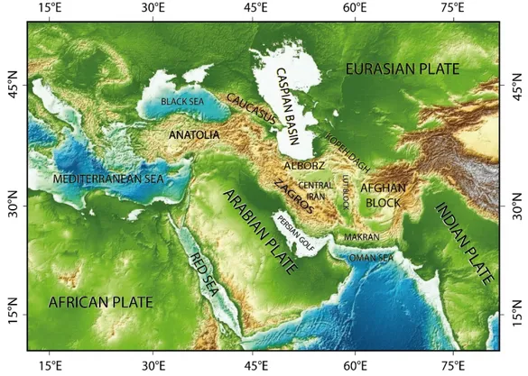
Iran is situated in the Alpine–Himalayan orogenic belt and has a complex tectonic history in late Mesozoic and Cenozoic which results from the convergence and collision of the Arabian Plate towards Eurasia (Fig. 1). The onset age of Arabia-Eurasia continent-continent collision matter of discussion (e.g., McQuarrie et al., 2003; Guest et al., 2006b). Timing estimates for the inception of the collision include Late Cretaceous (Stocklin, 1974; Berberian and Berberian, 1981; Alavi, 1994), Eocene (Hempton, 1987), latest Eocene–Early Oligocene (Jolivet and Faccenna, 2000; Hessami et al., 2001; Robertson et al., 2006; Allen and Armstrong, 2008; McQuarrie and van Hinsbergen, 2013, Neill et all., 2015), Oligocene (Yilmaz, 1993), Oligocene–Miocene (Berberian
et al., 1982), Early to Middle Miocene (Robertson, 2000), Middle Miocene (Dewey and Sengör, 1979; Sengör and Kidd, 1979, Guest et al., 2006b), Middle to Late Miocene (Homke et al., 2004), Late Miocene (Stoneley, 1981).
Fig. 2. Teleseismically recorded earthquakes of Iran in a period 1964–2004 (pink dots), from Tartar et al, (2007), with GPS velocities of points in Iran relative to stable Eurasia from Vernant et al., (2004) shown by red arrows.
Maximum deformation related to Arabia-Eurasia convergence in the Cenozoic has been-and is at present day- accommodated mainly by displacement in the active fold-and-thrust belts of the Zagros, Alborz and Kopeh Dagh (e.g., Berberian and King, 1981; Allen et al., 2004, Mattei et al., 2012), whereas, the fault-bounded crustal blocks of central Iran (Yazd, Tabas, and Lut blocks), show little internal deformation (Vernant et al., 2004, Mattei et al., 2012, 2015). This deformation model is in agreement with the distribution of seismic and geodetic data (Fig. 2) and shows that at longitude 55°E, the ~22 ± 2 mm/yr of Arabia-Eurasia convergence rate is mostly accommodated in the Zagros fold-and-thrust belt (~9 ± 2 mm/yr) and in the Alborz and KopehDagh Mountains (~8 ± 2 mm/yr), whereas only ~4 ± 2 mm/yr is taken up in central Iran (Vernant et al., 2004). Since initial collision along the Bitlis-Zagros suture, the Arabian plate has shifted ~300–500 km toward the north with respect to stable Eurasia (Allen et al., 2004).
2. Study Area
2.1. Alborz Range
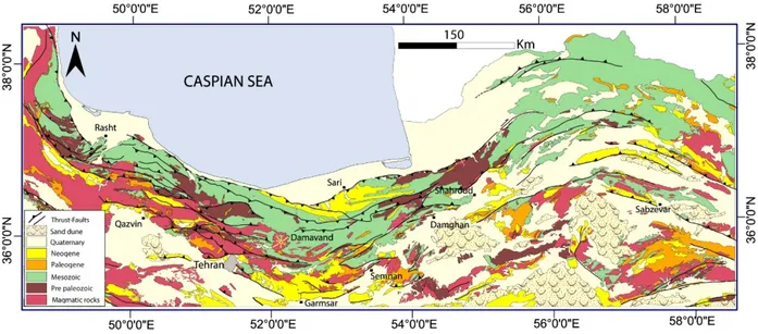
The Alborz (also written as Alburz, Elburz or Elborz) Mountains system is located along the northern margin of Arabia-Eurasia collision zone (Fig. 1) and forms a gently curved east-west range (Fig.3) in northern Iran (Stöcklin, 1974). It extends in a sinuous shape for ca. 1200 km from the Talesh in north-west to the Parapamisus Mountains of northern Afghanistan, to the east, and could be divided into three main parts including: Western Alborz, Central Alborz and Eastern Alborz respectively. Mount Damavand (Fig. 3), a dormant volcano and the highest peak in Iran and the Middle East with ~5671 m elevation, is situated in the Central Alborz range.
Fig. 3. Generalized geological-structural map of the Alborz. Geological unites modified from geological maps of Iran published by Geological Survey of Iran, and the faults modified from Tectonic Map of Iran. Nogole Sadat et al, (1993).
The Alborz range is the result of several tectonic events (e.g., Alavi, 1996) from the early Mesozoic, Cimmerian orogeny, to the present-day stage of intracontinental deformation related to the convergence between Arabian and Eurasian plates (Allen et al., 2003; Zanchi et al., 2006; Guest et al., 2007; Ballato et al., 2008; Zanchi et al., 2009).
During Permian to earliest Triassic times, the Neotethys ocean opened (Fig. 4) between the Arabian and Central Iranian blocks (Wilmsen et al., 2009) and in the Late Permian–Middle Triassic Neotethys spreading rates~20 cm/a) rapidly decreased to about 6cm/ a (Stampfli and Borel, 2002; Muttoni et al., 2009). Primary collision between Iranian microplate and southern margin
of Eurasia occurred in Late Permian – Early Triassic (260 – 249 Ma) (Sengör, 1984; Zanchi et al., 2006; Zanchi et al., 2009; Muttoni et al., 2009; Wilmsen et al., 2009).
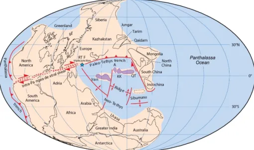
Fig. 4. Paleogeographic reconstruction of Pangea A for the Late Permian – Early Triassic based on paleomagnetic poles modified from Muttoni et al, (2009a). The star to the northeast of Adria indicates the hypothetical location of a ridge-trench-fault (RTF) triple junction adjoining the Gondwana, Laurasia, and Paleo-Tethys plates.
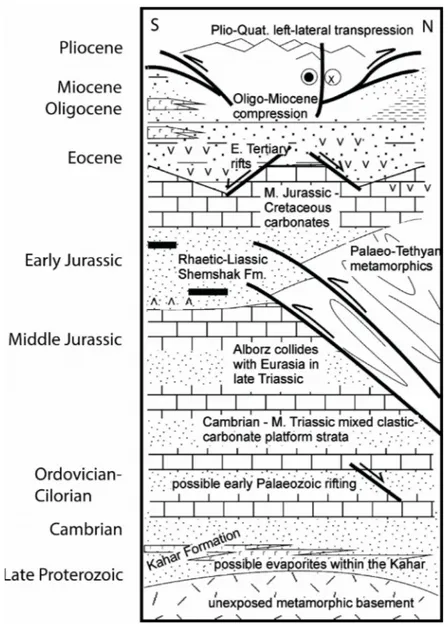
The Cimmerian orogeny is related to the Middle-Late Triassic collision of Iran (Fig. 4), a microplate of Gondwanan affinity, with Eurasia and to the closure of the Palaeotethys (Stöcklin, 1974; Davoudzadeh and Schmidt, 1984; Sengör, 1984; Stampfli et al., 1991; Stampfli and Borel, 2002). Most researchers suppose that the collision occurred in the Late Triassic (Fig. 5a) along a north dipping subduction zone (Stöclin, 1974; Alavi, 1991; Ruttner, 1993; Ricou, 1996; Alavi et al., 1997; Stampfli et al., 2001; Allen et al., 2003) which is now located at the latitude of the southern Caspian coast (Berberian & King, 1981; Alavi, 1991; Ruttner, 1993). Remnants of Paleo-Tethys suture are recognized as the Aghdarband suture in the Binnalud Mauntain NE Iran and eastward (Stöcklin, 1968; Baud and Stampfli, 1991; Alavi, 1991; Ruttner, 1993; Sheikholeslami & Kouhpeyma, 2012). The continuation of the suture zone to the west, was introduced by Alavi (1996) along the Central and Western Alborz (Talesh Mountain) is debatable (Zanchi et al., 2009b).The collision is distinguished by an angular unconformity between the Upper Precambrian to Middle Triassic sequences of North Iran and the Upper Triassic to Lower Jurassic
Shemshak Formation (Seyed-Emami, 2003; Fursich et al., 2005; Zanchi et al., 2009a, Wilmsen et al., 2009).
Long lived subduction of the Neo-Tethys Ocean beneath the south Eurasian margin led to opening of the Great Caucasus-Caspian back arc rifting (Fig. 5b)(Brunet et al., 2003; Kaz’min and Verzhbitskii., 2011) which reached its maximum extent during the late Cretaceous–early Paleogene. (Golonka, 2000; Golonka et al., 2006, 2007; Kaz’min and Tikhonova, 2006). Some researchers proposed that this Ocean was connected to the Sistan Ocean, which separated Lut
Fig. 5. Orthographic projection with Europe fixed in its present-day position from Stampfly and Borel, (2002). a) ̴180, b) ̴155 Ma. Paleopolesof Baltica are used as reference for the paleolatitudes.
from Afghanistan and Kopet-Dagh area (Golonka et al., 2006, 2007; Kaz’min and Tikhonova, 2006). The closure of this ocean is marked by ophiolites in northern Iran (Ricou, 1996; Sengör and Natalin, 1996). From the Early Cretaceous to Paleogene (Fig. 6a, b, c), the Turan platform was characterized by a tectonic quiescence (Golonka et al., 2007). In contrast, various pre-existing rock units (from Cambrian to Upper Cretaceous in age) in the southern Alborz and over the greater part of central Iran underwent a regional phase of shortening, uplift, and erosion (Stöcklin, 1968; Berberian and King, 1981, Guest et al., 2006) during the closure of some small oceanic basins further south in Iran, now preserved as Late Cretaceous ophiolite complexes. In the Alborz Mountains, this uplift and folding was associated with the deposition of Paleocene Fajan conglomerate (Allen et al., 2003; Zanchi et al., 2006, 2009, Ballato et al., 2013).
Before the Arabia–Eurasia collision, the Eurasian continental margin experienced arc magmatism as the result of the northwards subduction of Neo-Tethyan oceanic crust (Allen and Armestrong, 2008). A highly generative magmatic arc/back arc system (e.g., Kazmin et al., 1986; Verdel et al., 2011; Allen and Armestrong, 2008) was dominated across most part of Iran and Turkey between ~50 and ~35 Ma (Allen and Armestrong, 2008). Volcanism happened in an extensional setting during the Eocene along the southern margin of the Eurasian plate which was coincident with the renewal of northern motion of Africa–Arabia with respect to Eurasia and subduction of Neotethyan oceanic crust (e.g., Dewey et al., 1973, 1989). The pick of these volcanic activities was during the middle Eocene (Allen and Armestrong, 2008). In the southern margin of the Alborz, this volcanic arc was specified by the accumulation of a thick (up to 5 km) andesitic volcanics and volcanoclastics of the Karaj Formation (Stöcklin, 1974; Alavi, 1996). The volcanic activities decreased in the late Eocene and was little in the Oligocene time, although minor and scattered volcanism is maintained to the present day at the most part of collision zone (Pearce et al., 1990; Allen and Armestrong, 2008). Eocene normal faults in the Alborz Mountains (Guest et al., 2006a), stratigraphic evidence of Eocene subsidence in the Alborz Mountains and central Iran (Brunet et al., 2003; Hassanzadeh et al., 2004; Vincent et al., 2005; Guest et al., 2007b; Morley et al., 2009), geochemical and geochronological data (Verdel et al., 2011) and an Eocene metamorphic core complex in central and eastern Iran (Moritz et al., 2006; Verdel et al., 2007) indicate that this magmatic episode occurred during regional extension.
Fig. 6. Paleogeographic reconstructions of the Neotethyan region at (a) 145.5, (b) 100 Ma, (c) 50 Ma, (d) 15 Ma, modified from Richards, (2015). Abbreviations: A: Afghan block; C: Carpathians; CI: Central Iranian block; K =Kirsehir block; L: Lut block; M: Moesian Platform; P: Pontides; R: Rhodopes; SA: South Armenian block; SSZ: Sanandaj–Sirjan Zone; TAB: Tauride–Anatolide block.
During the late Eocene–early Oligocene, a regional phase of shortening developed in Alborz Mountains (Stöcklin, 1968; Berberian and King, 1981). The volcanic and volcanoclastic rocks of the Karaj Formation and marine evaporates of Kond Formation are unconformably overlain by terrestrial clastic and evaporite deposits (Fig. 7) of the Oligocene Lower Red Formation (e.g., Jackson et al., 1990; Amini, 1997; Davoudzadeh et al., 1997). Change in kinematics from an extensional to a compressional tectonic regime and ending of arc magmatism is concordant with the initiation of continental collision with the subduction of stretched continental Arabian lithosphere (“soft” collision) beneath Eurasia (Ballato et al., 2011). Reduction of convergence rate by 20 Ma was associated with the “hard”collision of unstretched and buoyant Arabian lithosphere, which ultimately caused widespread upper-plate deformation (Ballato et al., 2011; McQuarrie et al., 2013).
During the late Oligocene–early Miocene a shallow-water carbonate shelf (Qom Formation) developed over the central and northern Iran more than 1 km in thickness (Stöcklin and Setudehnia, 1977; Reuter et al., 2009). Acceleration of shortening rates, the development of higher topography and rapid exhumation in Southern Alborz must have been started from ~20 Ma (Fig. 7) (Allen et al., 2003; Ballato et al., 2008, 2010, 2011; Rezaeian et al., 2012, Ballato et al., 2013) which has been interpreted as a hard stage of collision by Ballato et al., (2011). Stratigraphic data confirm extension and subsidence during deposition of the Qom Formation (e.g., Hassanzadeh and Fakhari, 1997). In the Middle Miocene shallow marine deposits of the Qom Formation have been covered by basal conglomerates of the Middle-Late Miocene Upper Red Formation extended in the southern Alborz (Reuter et al., 2009; Ballato et al., 2011). The deposition of the Upper Red Formation occurred between 17.5-7.5 Ma. (Ballato et al., 2008). Thermo chronological data illustrate a significant tectonic event which is characterized by acceleration of exhumation and sedimentation rates in the Alborz Mountains (Ballato et al., 2011; Rezaeian et al., 2012).
Finally, in the latest Miocene (Fig. 7) the regional stratigraphy shows an erosional unconformity (or facies change from fine to coarse clastics) (Rezaeian et al., 2012) and tectonic tilting (Ballato et al., 2008) above the Upper Red Formation along the Southern flank of Alborz Mountains. The Upper Rea Formation has been overlain by thick conglomerates and sandstones of the
Hezardarreh and Kahrizak formations which were formed into an alluvial fan system in Southern Alborz. (Rieben, 1955). Rezaeian et al., (2012) suggest an exhumation from 6 to 4 Ma, which could be as a result of a regional re-organization of the Arabia-Eurasia collision (Allen et al., 2004) or to climate change, or both in conjunction.
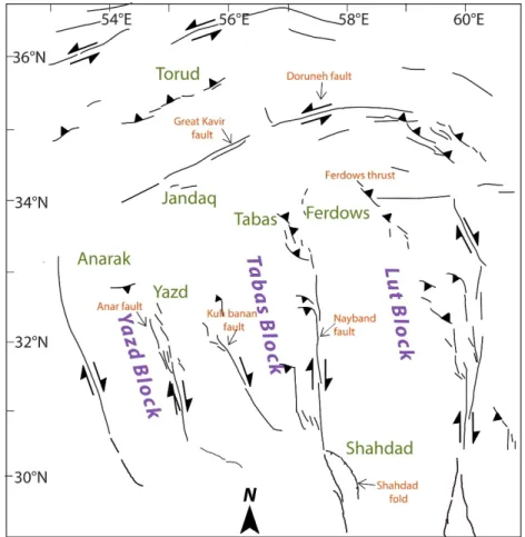
2.2. Central – East Iranian Microcontinent (CEIM)
Central Iran is a complex mosaic of several microcontinental blocks (Berberian 2014) with moderate relief surrounded by fold-and-thrust belts, within the Alpine-Himalayan orogenic system (Ramezani and Tucker, 2003) bounded by Alborz and Kopeh Dagh mountains to the North, the east Iranian ranges to the East and Zagros Chain and Makran to the West and South enclose the Central Iranian Plateau (Fig. 1). The microplate of Central Iran contains of three major tectonic blocks (Fig. 8) of the Lut Block, Tabas Block and the Yazd Block from East to West respectively (Davoudzadeh et al., 1981; Berberian and King 1981; Alavi, 1991) that are separated by mostly N-S right lateral strike slip major faults (e.g., the Nayband right lateral strike slip fault), and are separated from the Alborz belt by NE-SW left-lateral strike-slip and thrust faults (e.g., The Doruneh left lateral strike slip Fault),which have their individual stratigraphy, deformation style, and pattern of recent seismicity (Berberian and King, 1981; Berberian, 2014).
The Central and East Iranian Microcontinent (CEIM) (Takin, 1972), as an element of the Cimmerian microplate assemblage, has a complex history of geodynamic events. During the Cimmerian orogeny, the Iranian microplates detached from Northern Gondwana (Sengör, 1979; Berberian and King, 1981; Stampfli et al., 1991; Stampfli and Borel, 2002; Brunet et al., 2003; Angiolini et al., 2007; Zanchi et al., 2009a, 2015) in the Early Permian, during the opening of the Neotethys Ocean (Fig. 4), and collided with the Turan block (Eurasian) at the Early-Late Triassic or Early Jurassic (Fig.5. a) after the final consumption of the Palaeotethys ocean along a northward subduction zone (Stöcklin, 1974; Alavi, 1991; Ruttner, 1993; Alavi et al., 1997; besse et al., 1998; Allen et al., 2003; Muttoni et al., 2009; Mirnejad et al., 2013a). Paleomagnetic studies by Soffel et al., (1975); Wensink (1979, 1981, 1982); Wensink and Varekamp, (1980); Soffel and Förster, (1980); Soffel et al, (1995, 1996), Besse et al, (1998), Muttoni et al, (2009a), Mattei et al, (2014, 2015) is confirmed this scenario. The final collision happened during the late Triassic and is marked by deep erosion of the Eo-Cimmerian orogen and deposition of the Nayband and Shemshak molassic formations south of the orogenic belt (Bagheri and Stampfli, 2008; Fürsich et al., 2009; Zanchi et al., 2009). Since that time, the evolution of Central Iran was controlled by a sequence of back arc extentional and compressional events that were related to the
north-dipping Neo-Tethyan subduction zone (Berberian and King, 1981; Dercourt et al., 1986; Bagheri and Stampfli, 2008; Rossetti et al., 2010).
Fig. 8. Schematic fault map of central. The major tectonic domains and the study areas are shown.
These events caused the emplacement of the ophiolite melange belts around the Central East Iranian Microcontinent (Bagheri et al., 2008; Rossetti et al., 2010; shafaei moghaddam, 2014) (Fig.6.b). These ophiolites are the remnants of the branches of Neotethys oceanic basins (Sistan Ocean in the east, Sabzevar Ocean in the north, Nain–Baft Ocean in the west (Lindenberg et al., 1983; Tirrul et al., 1983; Dercourt et al., 1986; Stamfly and Borel, 2002; Philip and Floquet, 2000; Barrier and Vrielynck, 2008) that opened during the Early Cretaceous (Neocomian; e.g., Seyed-Emami et al.,1972) and closed during the late part of the Cretaceous (Dercourt et al., 1986; McCall, 1997, Bagheri and Stampfli, 2008, Shafaii Moghadam et al., 2009; 2014; 2015) and and document a polyphase tectonic evolution its Mesozoic–Cenozoic consumption along the Sanandaj–Sirjan Zone (Stöcklin, 1974; Sengör et al., 1988; Rossetti et al., 2010).
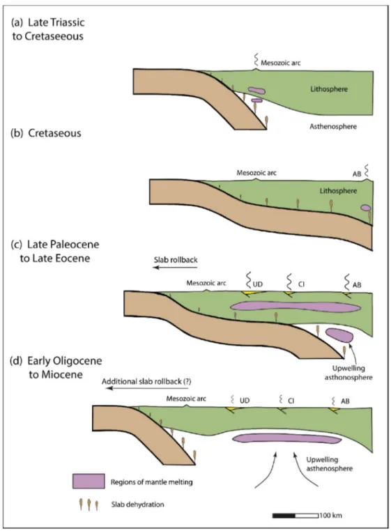
Figure 9. Summary of the development of the Iranian Eocene flare-up and subsequent asthenosphere-derived Oligocene magmatism in stages (a)-(d), modified from Verdel et al., (2011). Abbreviations: UD, Urumieh-Dokhtar magmatic belt; AB, Alborz Mountains; CI, central Iranian Eocene volcanics between Urumieh-Dokhtar and the Alborz Mountains.
Tertiary volcanic rocks are distributed over a large area in Iran, the Urumieh-Dokhtar belt (e.g., Omrani et al., 2008; Verdel et al., 2011), the Alborz Mountains (e.g., Brunet et al., 2003), northern
parts of Lut Block (e.g., Jung et al., 1984) and many relatively small locations in central Iran (e.g., Amidi et al., 1984). The Paleogene in Central Iran has begun with a basal conglomerate and sandstone which rests unconformably on older rocks, followed by an extensive volcanogenic unit consisting mainly of submarine and continental lava flows (from rhyolite to basalt) and dacitic tuffs (Berberian and King, 1981). The extensive and severe Eocene volcanic activity of Central Iran was explained as a result of the subduction of Neotethyan oceanic crust beneath Iran along the Main Zagros reverse fault (e.g., Jung et al., 1976; Verdel et al., 2011).
Several Eocene age metamorphic core complexes in central and eastern Iran (Moritz et al., 2006a; Kargaran et al., 2006; Verdel et al., 2007), Syndepositional Eocene normal faults in the Alborz and Central Iran (Guest et al., 2006a; Kargaran et al., 2011) and stratigraphic evidences of Eocene subsidence in Alborz and Central Iran(Brunet et al., 2003; Hassanzadeh et al., 2004; Morley et al., 2009), indicate that this magmatic stage occurred in a back arc extensional basin related to the rollback of the Neotethys slab(Fig. 9c) (e.g., Brunet et al., 2003; Vincent et al.,2005;Verdel, 2008; Verdel et al., 2011). A regional phase of shortening happened during the late Eocene–early Oligocene (Stöcklin, 1968; Berberian and King, 1981) represented by a regional unconformity at the base of the terrestrial clastic and evaporitic deposits of the Oligocene Lower Red Formation (e.g., Jackson et al., 1990; Amini, 1997). During this phase, the Lut Block experienced uplift (major Lut uplift) and no Oligocene-Miocene sediments were obviously deposited (e.g., Berberian, 1974; Berberian and King, 1981). The Lower Red Formation is overlain conformably by marine limestones and marls of Rupelian–Burdigalian age of the Qom Formation (Daneshian and Ramezani Dana, 2007). Bottrill et al. (2012) proposed that the Late Oligocene-Early Miocene marine carbonates were deposited as a result of roll-back of the southern Neo-Tethys slab shortly before breakoff. Although it is not clear when extension-related subsidence terminated (e.g., Guest et al., 2007), but the transition from marine to terrestrial clastics of Upper Red Formation during the Burdigalian (Amini, 1991, 1997) recommends a major shift in subsidence scheme at this time (Guest et al.,2007). The Qom Formation is conformably replaced by gypsum-bearing red beds of the Miocene Upper Red Formation which has been dated between 17.5 and 7.5 Ma (Ballato et al., 2008). The Upper Red Formation is overlain by the Pliocene conglomerate, has been dated ~6.2 Ma by Ballato et al. (2008), which has been correlated with the Hezardarreh and
Bakhtiyari Formations of the Alborz basin and the Zagros mountains respectively (e.g., Rieben, 1955).
3. Overviews of previous Paleomagnetic studies in Iran
The paleomagnetic investigations of Iran have been done to clarify three main issues: - Affinity of Iran to Gondwana during the Paleozoic.
- The reconstruction of the late Paleozoic–early Mesozoic northward drift of the Cimmerian blocks
- Large counterclockwise Rotation of Central East Iranian Microplate (CEIM) respect to the Eurasia from Triassic.
The first paleomagnetic studies in Iran, have been done to reconstruct the pre-Cimmerian tectonic evolution of Iran. Becker et al. (1973) reported paleomagnetic results of late Precambrian to Lower Cambrian rocks and iron ores of Bafq area and suggested that, like India, Central Iran was previously part of Gondwanaland. Soffel et al. (1975) published the paleomaganetic data of Infracambrian, Ordovician and Permian rocks of Central Iran which support the similarity of polar wander paths of India and Central Iran. Paleomagnetic results of Basaltic rocks of Late Devonian Early Carboniferous Geirud Formation of the Alborz Mountain confirm that during the Paleozoic, the Alborz range was part of former Gondwanaland (Wensink et al., 1978). Wensink, (1983) used the Paleomagnetic results of Lower Devonian Red beds of Central Iran to show a Gonadwana position for the Iranian- Afghan microcontinent in Paleozoic time. Besse et al. (1998) compiled a selection of paleopoles of the Carboniferous to present and revealed the Central Iran and Alborz were part of Gondwana during the Palaeozoic and rifted away by the end of the Permian. Investigation of the palaeomagnetic poles of Late Ordovician-earliest Carboniferous red bioclastic sediments of Shirgesht Formation in Anarak area by Muttoni et al., (2009), supported the affinity of Iran with Arabia (Gondwana) during this period of time. Wensink (1979) studied the paleomagnetic properties of the upper Permian Ruteh Lavas in the Alborz Range and believed that in Paleozoic and Mesozoic times these areas were placed the
coast of Arabia. This study was confirmed by Beese et al., (1998) in the same area and suggested a southern hemisphere of deposition during a reversed-polarity period.
The paleomagnetic results from Central Iran reported by Soffel and Forster, (1980) indicated that the reference point of Central Iran was in an intermediate latitude position between Eurasia and the Gondwanaland since the Late Paleozoic. After a slight tendency towards the south during the Permian, Central Iran moved again northward between the Permian and the Triassic. Besse et al. (1998) reported the paleomagnetic results of the Permo-Triassic boundary in the Upper Permian Hambast Formation close to city of Shahreza and from the Early Triassic Elika Formation close to city of Abadeh which sampled units were located at subequatorial paleolatitudes north of Arabian margin of West Gondwana as well reported by Gallet et al. (2000) in Hambast- Elika Formations of Abadeh section. Paleomagnetic data of Aruh laterite suggest equatorial paleolatitudes of c. 1°S to 1°N ± 5° for the Alborz area of northern Iran in the Late Permian (Muttoni et al., 2009). Wensink, (1982) discussed that the Early Jurassic Sorkh Shale Formation of Tabas region placed at 11°S, close to the coast of Arabia. Soffel et al. (1995, 1996) investigated the Triassic basalts in the Sirjan area and the Early Triassic Abyaneh Formation of Natanz area. They concluded that the Triassic pole is situated in the vicinity of other Late Palaeozoic-Early Mesozoic poles of the CEIM and is far away from the Triassic pole position for the Turan Plate. They argued that the Triassic pole position from the Natanz area (outside the CEIM) is in good agreement with the mean Triassic pole of the Turan plate indicating that the area to the west of the CEIM was close to the Turan Plate during the Triassic. Besse et al. (1998) suggested that the poles from the Early Triassic Sorkh Shales (Wensink, 1982) and Natanz (Soffel et al., 1995, 1996), both from central Iran, are situated at the same angular distance from their sampling sites as the Sirjan poles (Soffel et al., 1995, 1996), which are from the southernmost continental sliver of Iran. Muttoni et al. (2009) reported paleomagnetic results in the same area with Wensink, (1982) in the Early Triassic (Brönnimann et al., 1973) Sorkh Shale Formation in the Shotori Range near the town of Tabas. Interpretation of the inclination data from sampled sites indicate a palaeolatitude of approximately 9°±2.5°which is similar to Wensink, (1982) palaeolatitude (c.11°±8°) for Sorkh
Shale sites from the same general area of this study. Despite of Wensink, (1982), Muttoni et al. (2009) chose a northern hemisphere palaeolatitude, as suggested by Besse et al., (1998). Soffel
et al. (1996) sampled broadly in Nakhlak, Natanz, Saghand and Sirjan areas of the Early, Middle and Late Triassic ages and suggested that the Iranian Plate (without the CEIM, which is considered
Fig. 11. Most reliable Paleomagnetic rotations from the Central Iran-East Iranian Microcontinent (CEIM) and the Alborz Mauntain. For more details see chapter 2.
as a separate unit) was located close to the southern margin of the Turan Plate, whereas the CEIM was in a more southeast position.
Late Triassic reddish limestones have been sampled by Besse et al., (1998) in the Abadeh area, close to the town of Waliabad which confirm a period of rapid northward motion of Iran. Muttoni et al. (2009) sampled the sedimentary sequence of the late Early–late Middle Triassic Alam Formation in the Nakhlak area and the sedimentary sequence of the lower part of the Ashin Formation of late Middle Triassic of Central Iran. The paleomagnetic results suggest considerable European affinity of the sampled units and local vertical-axis tectonic rotations of the eastern
part of the Nakhlak structure. The calculated palaeolatitude for tow combined sites of Alam Formation is approximately 21°N ± 4° which shows the sampled locality is close to the European margin in late Early Triassic times.
The lower to middle Jurassic have been much less studied than the other sequences. Besse et al., (1998) worked on Shemshak Formation of Alborz Range but they could isolate only a low-temperature component of single polarity. A comprehensive history of the paleomagnetic investigations of Late Mesozoic-Cenozoic is given in chapter 2.
4. Remaining problems and aims
As previously mentioned, the paleomagnetic researches in Iran have mainly been focused on the reconstruction of the late Paleozoic early Mesozoic northward drift of the Cimmerian blocks (Besse et al., 1998; Muttoni et al., 2009a, 2009b) and the hypothesis of Soffel et al., (1996) that implies a 135° counterclockwise block rotation which has occurred between the internal part of central Iran and Europe since the Middle Triassic, an hypothesis that is based on sparse data from the Triassic sequence of Nakhlak ( Muttoni et al., 2009a). In contrast, several open issues regarding the tectonic and stratigraphic evolution of Iran have not been targeted by paleomagnetic researches. These include discrepant views on the Mesozoic paleogeography of the CEIM in Central Iran (compare Stampfli and Borel, 2002; Barrier and Vrielynck, 2008; Wilmsen et al., 2009), lack of paleomagnetic data to determine the exact time of drifting away Iran from Gondwana, the latitudinal drift of Iran and its relationships with the Turan plate after the Cimmerian collision (see Mattei et al., 2014 for a discussion), the debated origin of the curved shape of the Alborz and Kopeh Dagh ranges (Hollingsworth et al., 2010; Cifelli et al., 2015), lack of paleomagnetic data from Jurassic to Cenozoic units (Wensink , 1982; Bina et al., 1986; Soffel et al., 1996; Ballato et al., 2008), leaving the post-Cimmerian history of central Iran poorly constrained (Mattei et al., 2012).
The main objectives of this study are:
- To define the amount of paleomagnetic rotations in Central Iran since Oligocene time, and the relationship between these rotations and the major strike-slip faults kinematics.
- To reconstruct the paleogeographic evolution of the CEIM and Alborz range.
- To give constraints on the origin of the curved shape of the Alborz and Kopeh-Dagh orogens.
5. Outline of the thesis
In chapter two, I revise previously published paleomagnetic data from CEIM and Alborz Mts. and present new paleomagnetic data from the Upper Jurassic Bidou Formation (Fig. 12) from Central Iran (CEIM). I anticipate that these paleomagnetic data are suitable to identify two main episodes of counter-clockwise (CCW) vertical axis rotations that occurred in Central Iran in the Late Jurassic–Early Cretaceous and after the Middle–Late Miocene, and to constrain the timing of Neogene oroclinal bending in the Alborz range. This chapter has been published in Journal of Asian Earth Sciences, vol. 102, 15 April 2015, Pages 92–101 by Massimo Mattei, Francesca Cifelli, Giovanni Muttoni and Hamideh Rashid.
In chapter three, I present preliminary results of paleomagnetic study from Upper Red Formation of eastern Alborz (Jajarm), central Alborz (Semnan) and western Alborz (Alamut nd Manjil) and Shahdad thrust-fold belt (Fig. 12) to constrain the tectonic and kinematic evolution of these curvature belts during the Neogene. The primary results, confirm the orocline bending as an effective mechanism to curvature shape of these to tectonic systems.
In chapter four, to characterize the main intracontinental fault of the Arabia–Eurasia collision zone and to define the deformation style across this tectonic boundary, I combined magnetic fabrics (AMS) and structural data from the Upper Jurassic Garedu Red Beds Fmormation at the western boundary of the northern Shotori Range (Fig. 12). The geometrical relationships are typical of a transected fold and suggest that the Late Cretaceous and Tertiary shortening events of Central Iran were accommodated by a dextral transpressional tectonics along the tectonic boundary between Tabas and Lut blocks. Results from this study underline the importance of the re activation of pre-existing tectonic structures and emphasize the role of the right-lateral transpressional deformation along this main tectonic boundary of Central Iran. This chapter has been published in Geophysical Journal International, vol. 193, pages 1153-1165 by Francesca Cifelli, Massimo Mattei, Hamideh Rashid and Jalil Ghalamghash.
In chapter five, I present new AMS and structural results from the Ferdows active fold–thrust system in the Lut block, Central Iran (Fig. 12), that establish a relationships between the recent tectonics of the area and the evolution of the magnetic fabric. I show that a well-developed magnetic fabric of pure tectonic origin can form also in poorly deformed rocks, which lack evidence of pervasive internal deformation. In particular, I show that the different types of magnetic fabric observed at Ferdows fold–thrust system cannot be explained simply using different degrees of LPS, and that late folding internal strain has to be considered. The implication for the tectonic evolution of the Ferdows fold and thrust system are also discussed. This chapter has been published in Journal of Asian Earth Sciences, vol. 108, 15 August 2015, Pages 48–57 by Hamideh Rashid, Francesca Cifelli and Massimo Mattei.
Chapter six, I present a synthesis of the work, summarizes conclusions reached in each chapter and develop a comprehensive evolutionary paleogeographic map of Iran since Upper Jurassic.
Fig. 12. Tectonic map of Iran showing the main tectonic provinces and the main active faults. The red squares with white numbers inside represents the location of the paleomagnetic sites of this study.
Post-Cimmerian (Jurassic–Cenozoic) paleogeography and vertical axis
tectonic rotations of Central Iran and the Alborz Mountains
Massimo Mattei, Francesca Cifelli, Giovanni Muttoni and Hamideh Rashid This chapter has been published in 2015:
Journal of Asian Earth Sciences, vol. 102, Pages 92–101
http://dx.doi.org/10.1016/j.jseaes.2014.09.038
Keywords: Jurassic, Central Iran, Alborz, Paleomagnetism
Abstract:
According to previous paleomagnetic analyses, the northward latitudinal drift of Iran related to the closure of the Paleo-Tethys Ocean resulted in the Late Triassic collision of Iran with the Eurasian plate and Cimmerian orogeny. The post-Cimmerian paleogeographic and tectonic evolution of Iran is instead less well known. Here we present new paleomagnetic data from the Upper Jurassic Bidou Formation of Central Iran, which we used in conjunction with published paleomagnetic data to reconstruct the history of paleomagnetic rotations and latitudinal drift of Iran during the Mesozoic and Cenozoic. Paleomagnetic inclination values indicate that, during the Late Jurassic, the Central-East-Iranian Microcontinent (CEIM), consisting of the Yazd, Tabas, and Lut continental blocks, was located at low latitudes close to the Eurasian margin, in agreement with the position expected from apparent polar wander paths (APWP) incorporating the so-called Jurassic massive polar shift, a major event of plate motion occurring in the Late Jurassic from 160 Ma to 145–140 Ma. At these times, the CEIM was oriented WSW–ENE, with the Lut Block bordered to the south by the Neo-Tethys Ocean and to the southeast by the Neo-Sistan oceanic seaway. Subsequently, the CEIM underwent significant counter-clockwise (CCW) rotation during the Early Cretaceous. This rotation may have resulted from the northward propagation of the Sistan rifting-spreading axis during Late Jurassic–Early Cretaceous, or to the subsequent (late Early Cretaceous?) eastward subduction and closure of the Sistan oceanic seaway underneath the continental margin of the Afghan Block. No rotations of, or within, the
CEIM occurred during the Late Cretaceous–Oligocene, whereas a second phase of CCW rotation occurred after the Middle-Late Miocene. Both the Late Jurassic–Early Cretaceous and post Miocene CCW rotations are confined to the CEIM and do not seem to extend to other tectonic regions of Iran. Finally, an oroclinal bending mechanism is proposed for the origin of the curved Alborz Mountains, which acquired most of its curvature in the last 8 Myr.
1. Introduction
The present-day structural configuration of Iran (Fig. 1) is the result of a complex history of geodynamic events. These include the collision of the Central-East-Iranian Microcontinent (CEIM sensu Takin, 1972), comprised of the Yazd, Tabas, and Lut blocks, with the southern margin of Eurasia during the Late Triassic Cimmerian orogeny (Sengör, 1984; Zanchi et al., 2006, 2009a,b; Muttoni et al., 2009a), the Late Jurassic–Cretaceous opening of small oceanic basins around the CEIM, and the closure of these basins during Late Cretaceous, in connection with the northward motion of the Arabian Plate and closure of the Neo-Tethys Ocean (Stöcklin, 1974; Dercourt et al., 1986; Sengör et al., 1988; McCall, 1997; Stampfli and Borel, 2002; Bagheri and Stampfli, 2008; Rossetti et al., 2010). Since the Cenozoic, shortening related to the Arabia–Eurasia convergence has been taken up mainly by tectonic displacements in the Zagros, Alborz, and Kopeh Dagh thrust-andfold belts, whereas the intervening, fault-bounded crustal blocks of the CEIM seem to show little internal deformation (Fig. 1).
The Alborz and Kopeh Dagh Mountains in north Iran constitute a system of strongly curved, mostly double-verging orogens (Fig. 1). In particular, the Alborz range is a ca. 100-km-wide, sinuous orogenic belt that stretches E–W for ca. 600 km (e.g., Allen et al., 2003; Guest et al., 2006), and comprises Late Triassic Cimmerian structures (Zanchi et al., 2006) reactivated during the Late Cenozoic Arabia–Eurasia convergence and associated relative motion between the stable and rigid South Caspian Basin in the north and the CEIM in the south (e.g., Jackson et al., 2002; Allen et al., 2003).
The most peculiar feature of the CEIM (to the south of the Alborz–Kopeh Dagh range) is the occurrence of an Upper Mesozoic ophiolitic ‘ring’, the so-called ‘Coloured Mélange’, which
bounds its most internal part (Fig. 1). This ophiolitic ring is a remnant of Mesozoic peri-Tethyan oceanic basins that formed in the upper plate of the Neo-Tethyan subduction, and document a polyphase tectonic evolution during its Mesozoic–Cenozoic consumption along the Sanandaj– Sirjan Zone (Stöcklin, 1974; Sengör et al., 1988). The CEIM is affected by a complex system of N– S-trending dextral faults, which separate the Yazd, Tabas and Lut blocks causing intensive N–S dextral shearing in the whole area (Walker and Jackson, 2004)(Fig. 1). The left-lateral Great Kavir– Doruneh fault system, crossing the northern part of the CEIM, currently bounds this deformational system to the north.
Fig. 1. Tectonic map of Iran showing the main tectonic provinces and the main active faults. Numbers represent sampling localities from the literature discussed in the text (see also Table 1). The red square represents the location of the paleomagnetic sites of this study from the siliciclastic member of the Bidou Formation from the Kerman area.
Despite this complex tectonic history, paleomagnetic data from Iran are very sparse and have been mainly used to unravel its preCimmerian tectonic evolution (Muttoni et al., 2009a, b; see
also Besse et al., 1998). These data show that the Iranian block(s) was (were) located close to the Arabian margin of Gondwana in the Paleozoic, drifted off this margin attaining subequatorial palaeolatitudes in the Late Permian-early Early Triassic, and approached the Eurasian margin by the late Early Triassic. In contrast, several open issues regarding the tectonic and stratigraphic evolution of Iran have not been targeted by paleomagnetic research. These include discrepant views on the Mesozoic paleogeography of the CEIM in Central Iran (compare Stampfli and Borel, 2002; Barrier and Vrielynck, 2008; Wilmsen et al., 2009), the debated origin of the curved shape of the Alborz and Kopeh Dagh ranges (Hollingsworth et al., 2010; Alimohammadian et al., 2013), and the latitudinal drift of Iran and its relationships with the Turan plate after the Cimmerian collision (see Mattei et al., 2014 for a discussion).
In this paper, we revise previously published paleomagnetic data from CEIM (Conrad et al., 1981; Wensink, 1982; Bina et al., 1986; Soffel et al., 1989, 1996; Mattei et al., 2014) and Alborz Mts. (Wensink and Varenkamp, 1980; Cifelli et al., submitted to Tectonics) and present new paleomagnetic data from the Upper Jurassic Bidou Formation from Central Iran (CEIM). We anticipate that these paleomagnetic data are suitable to identify two main episodes of counter-clockwise (CCW) vertical axis rotations that occurred in Central Iran in the Late Jurassic–Early Cretaceous and after the Middle–Late Miocene, and to constrain the timing of Neogene oroclinal bending in the Alborz range. A brief summary of previous results (Muttoni et al., 2009a, b; Mattei et al., 2014) is also provided on the post Cimmerian latitudinal drift of Iran and the long-term evolution of climate-sensitive sedimentary facies deposition during the Late Paleozoic–Mesozoic.
2. Previous paleomagnetic results
2.1. Jurassic paleomagnetic data
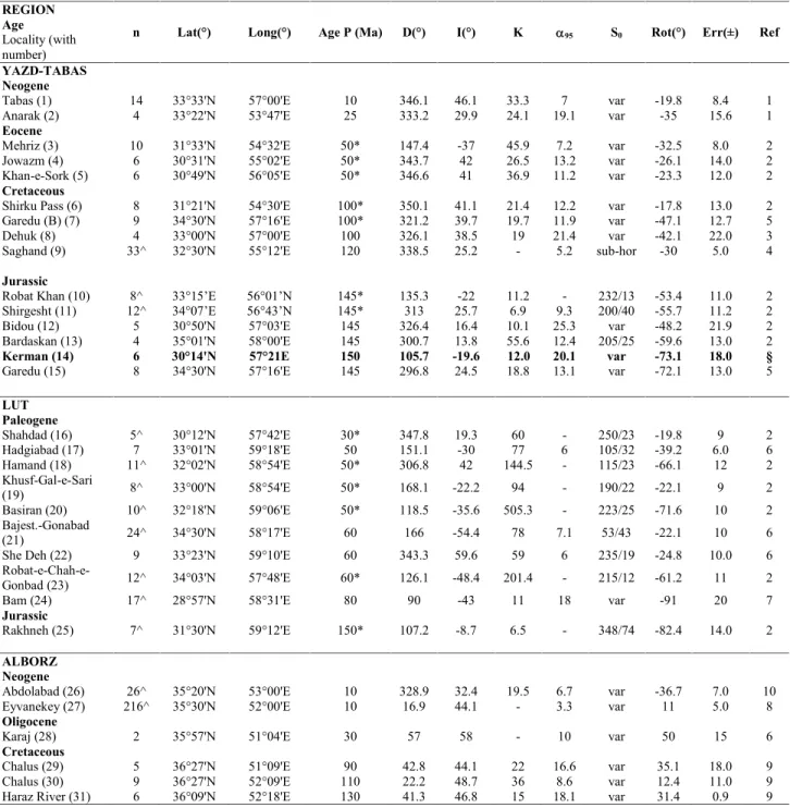
2.1.1. CEIMTable 1 – Paleomagnetic directions from CEIM and Alborz Mts.
REGION Age
Locality (with number)
n Lat(°) Long(°) Age P (Ma) D(°) I(°) K 95 S0 Rot(°) Err(±) Ref
YAZD-TABAS Neogene
Tabas (1) 14 33°33'N 57°00'E 10 346.1 46.1 33.3 7 var -19.8 8.4 1 Anarak (2) 4 33°22'N 53°47'E 25 333.2 29.9 24.1 19.1 var -35 15.6 1
Eocene
Mehriz (3) 10 31°33'N 54°32'E 50* 147.4 -37 45.9 7.2 var -32.5 8.0 2 Jowazm (4) 6 30°31'N 55°02'E 50* 343.7 42 26.5 13.2 var -26.1 14.0 2 Khan-e-Sork (5) 6 30°49'N 56°05'E 50* 346.6 41 36.9 11.2 var -23.3 12.0 2
Cretaceous
Shirku Pass (6) 8 31°21'N 54°30'E 100* 350.1 41.1 21.4 12.2 var -17.8 13.0 2 Garedu (B) (7) 9 34°30'N 57°16'E 100* 321.2 39.7 19.7 11.9 var -47.1 12.7 5 Dehuk (8) 4 33°00'N 57°00'E 100 326.1 38.5 19 21.4 var -42.1 22.0 3 Saghand (9) 33^ 32°30'N 55°12'E 120 338.5 25.2 - 5.2 sub-hor -30 5.0 4
Jurassic
Robat Khan (10) 8^ 33°15’E 56°01’N 145* 135.3 -22 11.2 - 232/13 -53.4 11.0 2 Shirgesht (11) 12^ 34°07’E 56°43’N 145* 313 25.7 6.9 9.3 200/40 -55.7 11.2 2 Bidou (12) 5 30°50'N 57°03'E 145 326.4 16.4 10.1 25.3 var -48.2 21.9 2 Bardaskan (13) 4 35°01'N 58°00'E 145 300.7 13.8 55.6 12.4 205/25 -59.6 13.0 2
Kerman (14) 6 30°14'N 57°21E 150 105.7 -19.6 12.0 20.1 var -73.1 18.0 §
Garedu (15) 8 34°30'N 57°16'E 145 296.8 24.5 18.8 13.1 var -72.1 13.0 5
LUT Paleogene Shahdad (16) 5^ 30°12'N 57°42'E 30* 347.8 19.3 60 - 250/23 -19.8 9 2 Hadgiabad (17) 7 33°01'N 59°18'E 50 151.1 -30 77 6 105/32 -39.2 6.0 6 Hamand (18) 11^ 32°02'N 58°54'E 50* 306.8 42 144.5 - 115/23 -66.1 12 2 Khusf-Gal-e-Sari (19) 8^ 33°00'N 58°54'E 50* 168.1 -22.2 94 - 190/22 -22.1 9 2 Basiran (20) 10^ 32°18'N 59°06'E 50* 118.5 -35.6 505.3 - 223/25 -71.6 10 2 Bajest.-Gonabad (21) 24^ 34°30'N 58°17'E 60 166 -54.4 78 7.1 53/43 -22.1 10 6
She Deh (22) 9 33°23'N 59°10'E 60 343.3 59.6 59 6 235/19 -24.8 10.0 6
Robat-e-Chah-e-Gonbad (23) 12^ 34°03'N 57°48'E 60* 126.1 -48.4 201.4 - 215/12 -61.2 11 2
Bam (24) 17^ 28°57'N 58°31'E 80 90 -43 11 18 var -91 20 7
Jurassic
Rakhneh (25) 7^ 31°30'N 59°12'E 150* 107.2 -8.7 6.5 - 348/74 -82.4 14.0 2
ALBORZ Neogene
Abdolabad (26) 26^ 35°20'N 53°00'E 10 328.9 32.4 19.5 6.7 var -36.7 7.0 10 Eyvanekey (27) 216^ 35°30'N 52°00'E 10 16.9 44.1 - 3.3 var 11 5.0 8
Oligocene
Karaj (28) 2 35°57'N 51°04'E 30 57 58 - 10 var 50 15 6
Cretaceous
Chalus (29) 5 36°27'N 51°09'E 90 42.8 44.1 22 16.6 var 35.1 18.0 9 Chalus (30) 9 36°27'N 52°09'E 110 22.2 48.7 36 8.6 var 12.4 11.0 9 Haraz River (31) 6 36°09'N 52°18'E 130 41.3 46.8 15 18.1 var 31.4 0.9 9 n = number of sites (or specimens when ^ is added). D, I = site mean declinations and inclinations calculated after tectonic correction. K and 95= statistical parameters after Fisher [1953]. S0= bedding attitude. Err (±): error for rotations values. Age P = Age of Paleopole (when the age is not certain * is added). Ref. numbers are: § = unpublished data; 1 = Mattei et al., 2012; 2 = Soffel et al. (1989); 3 = Wensink (1982); 4 = Soffel et al. (1996); 5 = Mattei et al. (2014); 6 = Bina et al. (1986); 7 = Conrad et al. (1981); 8 = Ballato et al. (2008); 9 = Wensink & Varekamp (1980); 10 = Cifelli et al., (in press). Reference Eurasia paleopoles are from Besse and Courtillot (2002) for 80-10 Ma and from Irving and Kent (2010) rotated to European coordinates by Mattei et al. (2014) for 200-90 Ma. N = reference number in figure 5.
The ages of paleomagnetic sites have been defined using stratigraphic constraints; reliable ages are available for the Jurassic Garedu (Kimmeridgian–Tithonian) and Bidou (Kimmeridgian–Berriasian) formations, the Cretaceous Dehuk Formation (Albian–Cenomanian) and Alborz volcanics (age) (Wensink and Varenkamp, 1980), and the Miocene Upper Red Formation (Ballato et al., 2008; Mattei et al., 2012; Cifelli et al., submitted). Radiometric ages have been reported for the Paleogene volcanic rocks (Conrad et al., 1981; Bina et al. 1986). For all the other sites, the stratigraphic ages has been calculated on the base of the stratigraphic age suggested in the original papers (Soffel et al., 1989; 1996).
Mattei et al. (2014) report paleomagnetic results from Kimmeridgian–Tithonian red beds of the Garedu Red Bed Formation cropping out in the Garedu syncline of the western Shotori Mountains (#15 in Fig. 1 and Table 1) (see also Cifelli et al., 2013). A welldefined ChRM component direction, stable at temperatures from 580–620 °C to ~670 °C, was isolated, and based on the presence of normal and reversed magnetic polarities and a positive fold test, it was considered primary in origin and acquired during (or shortly after) the deposition of the Garedu Red Bed Formation (Mattei et al., 2014). Soffel et al. (1989) isolated, at sites located near Bardeskan, ChRM directions of dual polarity that are similar to the pre-folding, low inclination ChRM directions of Mattei et al. (2014) (#13 in Fig. 1 and Table 1). In contrast, the ChRM directions of high inclination obtained by Wensink (1982), interpreted as prefolding in age (albeit with inconclusive fold test; Wensink, 1982), most probably represent a record of the post-folding, high inclination B component directions as isolated by Mattei et al. (2014). Soffel et al. (1989) reported paleomagnetic directions from 5 sites sampled from Jurassic sandstones and red sandstones from the Bidou area north of Kerman. Results show ChRM component directions of normal and reverse polarities that, after correction for bedding tilt, cluster either to the northwest or southeast with shallow inclination (#12 in Fig. 1 and Table 1), and are similar to the ChRM directions of the Garedu Red Bed Formation (Mattei et al., 2014). In the Tabas Block, Soffel et al. (1989) report results from two sites of Jurassic age that have ChRM directions oriented to the northwest and down or southeast and up (#10,11 in Fig. 1 and Table 1). In the Lut Block, one site of Jurassic age reported by Soffel et al. (1989) shows ChRM directions oriented southwest and up (#25 in Fig. 1 and Table 1).
2.2 Cretaceous paleomagnetic data
2.2.1 CEIMPaleomagnetic directions from Cretaceous units of the CEIM are very few and limited to the Tabas and Yazd blocks. Wensink (1982) sampled 6 sites from middle Cretaceous red sandstones and red limestone from the Dehuk village, to the east of the Shotori Range in the Tabas block (#8 in Fig. 1; Table 1). The mean ChRM direction for the analysed sites is oriented northwest and up, and is better grouped after than before tectonic correction, suggesting that the ChRM has a pre-folding origin. Soffel et al. (1989) reported results from Cretaceous volcanic and sedimentary rocks from
the Shirkuh Pass area with a mean ChRM direction, calculated from 8 sites, oriented northwest and down (#6 in Fig. 1; Table 1). Soffel et al. (1996, also reported in Besse et al., 1998) sampled Cretaceous limestone from the Saghand area in the eastern Yazd block. The ChRM mean direction, calculated from 33 specimens, is oriented northwest and down (#9 in Fig. 1; Table 1). Mattei et al. (2014) observed an intermediate B component direction oriented northwest and down in in situ coordinates in the Late Jurassic Garedu Red Bed Formation of the Shotori Mountains area (#7 in Fig. 1; Table 1). Site mean B component directions are clustered in in situ coordinates, while after correction for bedding tilt, they become sensibly more scattered, suggesting that they originated from a post-folding magnetic overprinting event of normal polarity, possibly associated with the Cretaceous deformation phase described by Ruttner et al. (1968).
2.2.2 Alborz
Wensink and Varekamp (1980) obtained ChRM directions oriented to northwest and down from 20 sites distributed in 3 different localities from several Cretaceous lava flows from the Chalus and Haraz valleys in the Western Alborz Mountains (#29,30,31 in Fig. 1; Table 1).
2.3 Paleogene paleomagnetic data
2.3.1 CEIMConrad et al. (1981) first reported paleomagnetic results from Paleogene volcanics from the southern part of the Lut Block of the CEIM. ChRM directions isolated in 17 samples from different localities are oriented to the east and up (#24 in Fig. 1; Table 1), and are better grouped after than before correction for bedding tilt (Conrad et al., 1981). Bina et al. (1986) reported paleomagnetic directions from Paleocene and Eocene volcanics from 3 different localities of the Lut Block. After correction for bedding tilt, the site-mean ChRM directions cluster either to the northwest and down or to the southeast and up (#17, 21, 22 in Fig. 1; Table 1). Soffel et al. (1989) reported results from a large number of sites sampled from 3 different localities in the Yazd Block (#3, 4, 5 in Fig. 1; Table 1) as well as from 5 localities in the Lut Block (#16, 18, 19, 20, 23 in Fig. 1;
Table 1). The ChRM directions isolated in these sites are oriented either to the northwest and down or southeast and up.
2.3.2 Alborz
Bina et al., (1986) reported data from volcanics from the Karaj area in the Western Alborz. Reliable results have been obtained for 15 samples, which show a mean ChRM direction oriented northeast and down (#28 in Fig. 1; Table 1).
2.4 Neogene paleomagnetic data
2.4.1 CEIMMattei et al. (2012) published paleomagnetic results from red marls and siltstones of the Upper Red Formation sampled in 2 localities of the CEIM (Tabas and Anarak, #1 and #2 in Fig. 1, respectively). In these localities, ChRM component directions were isolated and considered as primary in origin on the base of the positive reversal and fold tests. In tilt corrected coordinates, these component directions are oriented either to the northwest and down or southeast and up (#1 and #2 in Fig. 1; Table 1).
2.4.2 Alborz
Ballato et al. (2008) and Cifelli et al. (in press) reported paleomagnetic results from red marls and siltstones of the Upper Red Formation from two localities from the western and eastern sides of the southern Central Alborz. Ballato et al. (2008) isolated ChRM component directions from 216 samples from the Eyvaneikey magnetostratigraphic section, which are oriented either to the northeast and down or southwest and up (#27 in Fig. 1; Table 1). Cifelli et al. (in press) isolated ChRM component directions from 26 samples from the Abdolabad section, which are oriented either to the northwest and down or southeast and up (#26 in Fig. 1; Table 1).
3. PALEOMAGNETIC SAMPLING AND RESULTS
In the Kerman area of Central Iran (as part of the CEIM), we sampled 9 sites in the red marls and siltstones of the Upper Siliciclastic Member (Late Jurassic-Early Cretaceous) of the Bidou Formation (Zamani-Pedram, 2011), a lateral equivalent of the Magu Gypsum Formation and Garedu Red Beds Formation cropping out in the northern Tabas block (Wilmsen et al., 2009; Zamani-Pedram, 2011) (Fig.1). Sampling was carried out along the different flanks of the N–S-oriented Bolbulieh and Hossienabad fold systems, located to the southeast and east of Kerman, respectively (Azizan et al., 2009). The magnetic mineralogy of the sampled sediments was investigated on representative specimens using standard rock magnetic techniques. The stepwise acquisition of an isothermal remanent magnetization (IRM) was imparted using a pulse magnetizer up to 2.0 T fields. A three component IRM was imparted at 2.7 T, 0.6 T, and 0.12 T fields along samples orthogonal axes and thermally demagnetized according to the procedure of Lowrie (1990).
Fig. 2. Isothermal remanent magnetization (IRM) acquisition curves (a) and thermal demagnetization of a three-component IRM (b) from representative hematite-rich samples of the Bidou Formation red beds.
All samples show a progressive increase of IRM that does not reach saturation up to 2.0 T, suggesting the presence of a dominant high coercivity ferromagnetic mineral (Fig. 2a). Thermal demagnetization of a three component IRM confirms these results and helps defining the nature of the magnetic mineral. High-coercivity magnetic phases are prevalent and show maximum unblocking temperatures of about 680°C, which can be attributed to hematite (Fig. 2b).
A total of 84 cylindrical core specimens were subjected to progressive stepwise thermal demagnetization and the natural remanent magnetization (NRM) was measured after each demagnetization step with a 2G Enterprises DC-SQUID cryogenic magnetometer. The low-field magnetic susceptibility was measured after each heating step to monitor thermally induced alterations of the magnetic mineralogy. Heating steps of 100°C, reduced to 15-20 °C close to critical unblocking temperatures, were carried out from room temperature to a maximum of 670°C. The least-square analysis (Kirschvink, 1980) was applied to determine magnetic component directions. The maximum angular deviation (MAD) of the isolated magnetic components was generally <10°. Site-mean paleomagnetic directions were calculated using Fisher (1953) statistics.
Fig. 3. Vector component diagrams for the progressive demagnetization of representative samples from Bidou Formation red beds. Open and solid symbols represent projections on the vertical and horizontal planes, respectively.
Most of the samples show the presence of an initial A component isolated between room temperature and 180-240 °C, occasionally up to 400 °C (Fig. 3). This A component is generally oriented north and steeply down in in situ coordinates (Fig. 3), whereas upon correction for bedding tilt, it becomes more scattered. The A component, with an in situ overall mean direction of Dec. = 356.0° E, Inc. = 40.3° (α95 = 24.2°), is within error range aligned along a recent geocentric axial dipole field direction (GAD inclination = 54°), and is therefore interpreted as a recent viscous overprint.
After removal of the low-temperature A component, a well-defined characteristic remanent magnetization (ChRM) component is observed in 40% (34/84) of the samples at higher
temperatures between average values of c. 580–620°C or occasionally up to 670°C (Fig. 3). Demagnetization diagrams indicate stable behavior with demagnetization vectors aligned along linear paths directed toward the origin of vector component diagrams. Reliable site mean directions have been obtained from seven out of nine sampled sites (Table 2). Site mean directions are scattered in in situ coordinates, while after correction for bedding tilt, they cluster east and southeast and up (sites GA12, GA14, GA15, GA18) or southeast with a subhorizontal inclination (sites GA10-11) (Table 2; Figure 4). Site GA16 shows ChRM component directions broadly aligned along the present-day GAD magnetic field in in situ coordinates or oriented northeast and up in tilt-corrected coordinates; these component directions have been excluded from further analysis as possibly overprinted during recent times.
The overall mean ChRM component direction based on 6 site-mean directions is Dec. = 111.7°E, Inc. = -21.1° (k = 6, α95 = 29.6°) in in situ coordinates, whereas in tilt corrected coordinates, it becomes Dec. = 105.7°E, Inc. = -19.6° (k = 12, α95 = 20.1°) (Fig. 4; Table 1).
Table 2 – Paleomagnetic directions from Bidou Formation
Site Location Fm Lithology n/N S0 BTC ATC
Lat (°N) Lon(°E) D° I° K 95 D° I° K 95
GA10 30°08’49’’ 57°23’48’’ GA siltstones 3/10 variable 115.3 -9.9 12.5 36.4 110.5 2.5 13.7 34.6
GA11 30°11’35’’ 57°26’16’’ GA marls 4/9 variable 142.1 -43.6 13.8 25.6 117.8 -3.6 14.4 25.1
GA12 30°10’30’’ 57°24’46’’ GA siltstones 3/10 218,55 146.4 -16.2 46.8 18.2 127.1 -22.7 47.1 18.2 GA14 30°15’58’’ 57°17’47’’ GA siltstones 6/9 256,22 93.6 -40.4 18.6 15.9 90.1 -19.2 18.6 15.9 GA15 30°16’12’’ 57°16’44’’ GA marls 5/10 60,48 71.6 11.1 45.8 11.4 74.1 -35.8 45.8 11.4 GA16* 30°21’58’’ 57°17’58’’ GA siltstones 7/9 94,70 38.1 35.9 6.2 26.3 50.5 -13.1 6.2 26.3 GA18 30°17’17’’ 57°18’14’’ GA siltstones 6/8 85,20 105.5 -15.3 39.1 10.8 109.0 -33.9 39.1 10.8 Mean (6 sites) 111.7 -21.1 6.1 29.6 105.7 -19.6 12.0 20.1
Notes: Abbreviations: n/N—total number of stable directions at a site/number of demagnetized samples; S0—bedding attitude (azimuth of the dip and dip values). D°, I°— site mean declinations and inclinations calculated before tectonic correction (BTC) and after tectonic correction (ATC); K—precision parameter; α95—confident limit (statistical parameters after Fisher, 1953). Site-mean directions show declination scattering that persists after tectonic correction (from 74.1° E at site GA15 to 127.1° E at site GA12), and that is possibly related to local tectonic rotations. A tilt-corrected overall mean inclination of -19.6° (±17.2°, k = 16), calculated using the inclination-only statistics of McFadden and Reid (1982), confirms the result obtained with the Fisher statistics (see above). Acknowledging these complexities, and based on a fold test that is positive at 99% level of confidence (McFadden, 1990), we consider this high-temperature ChRM component as primary in origin and acquired during (or shortly after) deposition of the Bidou
Formation.
Paleomagnetic directions obtained from the Bidou Formation sites are similar to those obtained from the coeval Garedu Red Beds Formations from northern Tabas Block (Mattei et al., 2014), reinforcing the finding of a low-latitude position of Central Iran during Late Jurassic and the large amount of CCW rotation experienced by Central Iran since that time.
4. CHOICE OF REFERENCE PALEOMAGNETIC POLES
Previous paleomagnetic analyses indicate that the CEIM was located close to the Arabian margin of Gondwana in the Paleozoic, drifted off this margin attaining subequatorial palaeolatitudes in the Late Permian-Earliest Triassic, and approached the Eurasian margin by the late Early Triassic, to then maintain Eurasian affinity as deduced from Late Triassic and Cretaceous data (Muttoni et al., 2009a,b and references therein; see also Besse et al., 1998). Mattei et al. (2014) reported a low paleolatitude (~12° N ± ~5°) for the deposition of the Kimmeridgian–Tithonian (Late Jurassic) Garedu Red Bed Formation from the northern Tabas Block, which was found to be in good agreement with the low paleolatitudes predicted for Eurasia by the apparent polar wander paths (APWPs) of Kent et al. (2010) and Muttoni et al. (2013). These APWPs show the occurrence of a major and rapid shift in pole position of major plates (referred to as Jurassic massive polar shift;
Mattei et al., 2014) during the Middle to Late Jurassic that alternative curves from the literature tend to underestimate, and, for our purposes here, confirm an Eurasian affinity of Iran during the Jurassic (see Mattei et al., 2014 for a discussion). Therefore, Jurassic-Cenozoic paleomagnetic data from the CEIM and the Alborz Mountains have been compared to the Eurasian reference APWP curves to determine the amount of vertical axis rotations for each locality. In particular, we use the Kent and Irving (2010) North America APWP migrated into Eurasian coordinates for the time interval comprised between 200 and 90 Ma (Mattei et al., 2014), whereas for ages comprised between 80 and 10 Ma, we use the Besse and Courtillot (2002) Eurasian APWP.
5. VERTICAL AXIS ROTATIONS OF THE CEIM AND ALBORZ RANGE
Rotation values and associated 95% confidence limits, calculated according to the method of Demarest (1983), are reported in Table 1. In Figure 5, paleomagnetic rotations are displayed according to age of sampled rocks.
Jurassic paleomagnetic directions have been obtained for the CEIM at six localities in the Tabas and Yazd blocks (Fig. 5, #10-15) and one locality in the Lut block (Fig. 5, #25). All Jurassic sites from the CEIM show significant amounts of counter-clockwise (CCW) rotations, ranging between 45° (± 11°) and 82° (± 14°), with a mean value of 66° (± 13°).
Cretaceous paleomagnetic directions have been obtained at four localities in the CEIM (Fig. 5, #6-9) and three localities in the Western Alborz (#29-31). Paleomagnetic directions from the CEIM show CCW rotations comprised between 18° (± 13°) and 47° (± 13°), with a mean value of 34° (± 15°). In the Western Alborz, three paleomagnetic site-mean directions indicate CW rotation, comprised between 12° (± 11°) and 35° (± 18°), with a mean value of 28° (± 15°).
Paleogene paleomagnetic directions have been obtained at twelve localities in the CEIM (Fig. 5, #3-5 and #16-24) and one locality in the Western Alborz (#28). Paleomagnetic directions from the CEIM show CCW rotations ranging between 91° (± 20°) and 20° (± 9°), with a mean value of
43° (± 14°), whereas the single locality from the Western Alborz (# 28) is rotated CW by 50° (± 15°).
Fig. 5. Paleomagnetic rotation from the Central-East Iranian Microcontinent (CEIM) and the Alborz Mountains, calculated relative to the Kent et al., 2010 North America Apparent Polar Wonder Path (APWP) migrated into Eurasian coordinates for the time interval comprised between 200 and 90 Ma, and the Besse and Courtillot (2002) Eurasian APWP for the time interval comprised between 80 and 10 Ma. Numbers refer to data listed in Table 1.
Neogene results have been obtained from the Upper Red Formation of the CEIM (Fig. 5, #1-2) and in southern Central Alborz (#26-27). In the CEIM, paleomagnetic directions are rotated CCW (#1–2), whereas in southern Central Alborz, paleomagnetic directions from the Eyaneykey and Abdolabad sections (#26-27) indicate CW and CCW rotations, respectively.