INTEGRATING EXPERTISES AND AMBITIONS FOR DATA-DRIVEN DIGITAL
BUILDING PERMITS – THE EUNET4DBP
F. Noardo 1*. G. Malacarne2, S. Mastrolembo Ventura 3, L.C.Tagliabue 3, A.L.C. Ciribini3, C. Ellul4, D. Guler 5, L. Harrie6, L. Senger7, A. Waha8, J. Stoter 1
1 3D Geoinformation group, Delft University of Technology, Delft, The Netherlands – (f.noardo, j.e.stoter)@tudelft.nl 2Fraunhofer Italia Research, Bolzano-Bozen, Italy - [email protected]
3 Dept. of Civil, Environmental, Architectural Engineering and Mathematics, University of Brescia, Brescia, Italy - (silvia.mastrolemboventura, lavinia.tagliabue, angelo.ciribini)@unibs.it
4 Dept. of Geomatic Engineering, University College London, London, UK – [email protected]
5 Department of Geomatics Engineering, Istanbul Technical University, Istanbul, Turkey - [email protected] 6 Department of Physical Geography and Ecosystem Science, Lund University, Lund, Sweden - [email protected]
7 Institute of Construction Management and Digital Engineering, Leibniz Universität Hannover, Hannover, Germany - [email protected]
8 Cogital Ltd, London/Dusseldorf, UK/Germany – [email protected]
KEY WORDS: Digital Building Permits, 3D city models, BIM, Interoperability, Procedures, Regulations
ABSTRACT:
The digitalization of the process for building permit (involving the use of 3D information systems) is seen as a priority in a wide part of the world. Since it is a very multidisciplinary use case, involving a variety of stakeholders tackling complex issues and topics, some of them joined their efforts and skills in the European Network for Digital Building Permit. The initial activity of the network, after a review of on-going experiences, was a workshop to share knowledge about the topics involved and to identify the main ambitions of the network with respect to three pillars (i.e. Process – Rules and Requirements – Technology) and the related requirements. It was achieved through a collective brainstorming activity guided by digital tools, whose results were further analysed in a post-processing phase. Such results are presented in this paper and will be the base for planning the future network activity.
* Corresponding author
1. INTRODUCTION
From recent years a worldwide digitalisation process is ongoing in the AEC (Architecture, Engineering, Construction) industry. The building permit process is considered as a promising use case for automation via digital data about buildings and the built environment (Eastman et al., 2009; Lee et al., 2016).
A building permit is the final authorisation, granted by public authorities, that gives permission to start the construction phase of a building project. The permit is part of a process of town planning with the aim of guaranteeing a sustainable and controlled development, benefiting communities, environment and economy (Siew et al., 2013; DCLG, 2015).
However, the currently still manual building permit process is a subjective, error-prone, and time-consuming activity that may lead to ambiguity, inconsistency in assessments and delays over the entire construction process (Malsane et al., 2015). The process of issuing a building permit consists of several steps, where a great number of stakeholders are involved, using many pieces of information. In many countries this information is still handled in analogue formats (or, at best, PDF documents) and in 2D. Moreover, in practice, the involved procedures and data are very heterogeneous and, in most cases, they are not digital and can also be relatively informal – e.g. decisions depend on the local knowledge and expertise of individuals.
Recently, in fact, there has been an increasing interest in how the use of 3D information systems could be relevant for improving both the efficiency and the consistency of the planning permit processes, forming a core element of a move to fully digital planning and permitting. Furthermore, in Europe,
the digitalisation of the building permit process was especially pushed by the Directive 2014/24/EU of the European Parliament and of the Council on public procurement.
1.1 Preliminary investigations
The digital innovation of the building permit process can be expected to be more time and cost saving than manual processing. Most of the available studies started from the investigation of the state of practice and workflows, by sending questionnaires, interviewing involved stakeholders and analysing current processes with related required resources (i.e. time and money).
Some investigations could quantify such advantages in terms of economic savings and efficiency increase. Plazza et al. (2019) analysed the process in Italy, while Samasoni and Rotimi (2014) studied the New Zealand case, calculating economic benefits due to the use of such a system of approximately $67.3 million per annum, taking into account time saved by applicants and Building and Construction Authorities, and benefits to contractors. From the Estonian final report of the project introducing digital building permit in the country (Future Insight Group, 2019), a cost/benefit analysis revealed a potential saving of more than 500,000 euro per year, without considering the advantages and savings given by the improvement in rules clarity and interpretations, which are pointed out as source of time and effort savings also from the designers’ side. The related report by PwC (2019) also highlights a possible saving of 45 FTEs (full time equivalent) workforce per year, with an increase in efficiency of about 8-10% in workload. Such saved resources could be instead dedicated to a more careful check of the incompliances, the most complex cases and more advanced The International Archives of the Photogrammetry, Remote Sensing and Spatial Information Sciences, Volume XLIV-4/W1-2020, 2020
analysis that could help solving issues currently reported (e.g., exceptions, specific cases, high number of requests, specific plan needs), with a general increase of the quality of the built environment and of the job task. In addition, the proceedings burden would be reduced. In the UK, the Centre for Digital Built Britain report (CDBB, 2019) concluded that “the concept of automated checking can bring tangible advantages including increased efficiency and a reduction in the costs of compliance checking” and further recommended that there is an opportunity of “transformation of the regulatory compliance system”. According to the same report, digitalising and automating the system could enable a new level of transparency, and inherently build in the “Golden Thread”. Although these numbers are presented outside their context and come from different cases, they all demonstrate a positive impact deriving from the introduction of a digital building permit system.
1.2 Representation and data management technologies Different technologies are nowadays mature enough to be realistically considered for their systematic adoption in such a system supporting automation. They have in common the aim of representing and effectively managing data (in particular spatial, 3D, data), which are central to this change of approach for building permit issuing.
First is Building Information Modelling (BIM), development of Computer-Aided Drawing (CAD) tools, originally intended to mainly support the design phase of buildings and construction works in the AEC field, and later enriched with powerful project, asset and facility management functionalities. It is a 3D information system modelling from the smallest elements of a building (e.g., bolts) to the construction site, following consequent semantic structures (Eastman et al., 2011). A parametrically modelled solid geometry is usually stored. Reference standards for BIM-based data exchange and interoperability are the Industry Foundation Classes (IFC) by buildingSMART.1
Geoinformation, managed by Geographical Information Systems (GIS), and its 3D version, in 3D city models, are the other critical components for the representation and analysis of the city and the landscape, which are the context of the planned construction (Biljecki et al., 2015). They have an essential role in assessing their reciprocal impacts. The scope of representation of geoinformation, and related semantics, goes approximately from the building (possibly segmented in generalised representations of its parts, such as walls and roofs) to wider pieces of lands (e.g., region, country or wider). In this case, geometry is usually an explicit boundary representation. Georeferencing is mandatory in this case, while unusual for BIM. Reference standard, among others such as the INSPIRE2 data model, is CityGML by Open Geospatial Consortium (OGC)3, which has to be also considered in its CityJSON4 implementation.
The integration of geoinformation with BIM (contracted GeoBIM) is increasingly studied and discussed (Liu et al., 2017; Fosu et al., 2015; Arroyo Ohori et al., 2018; Kang et al., 2015; Sun et al., 2019; Isikdag et al., 2009; Noardo et al., 2020b); moreover it is essential for the digitalisation of the building
1
https://www.buildingsmart.org/standards/bsi-standards/industry-foundation-classes/ (accessed 07/07/2020)
2European Directive establishing an Infrastructure for spatial information in
Europe. https://inspire.ec.europa.eu/data-specifications/2892 (accessed 07/07/2020).
3http://www.citygmlwiki.org (accessed 07/07/2020) 4https://www.cityjson.org (accessed 07/07/2020)
permit use case. Finally, linked-data technology born in the context of semantic web can be relevant. It allows the structuring of data in shared knowledge graphs in order to be easily exchanged, interpreted and enriched through inference or enhanced data retrieval functionalities. Linked data technology can help in integrating the data and verify some constraints (e.g., Hbeich, 2019).
1.3 The need for a network
As a result of initial investigations, it was acknowledged that a complex multidisciplinary, multi-stakeholders and international strategy is necessary to achieve relevant results in reasonable times, by sharing outcomes, experiences and efforts. With this spirit, the European Network for Digital Building Permits (EUnet4DBP)5 was born at the beginning of 2020, bringing together members from several countries and including expertise in BIM, 3D City Modelling, building regulation, urban planning and software development.
This paper firstly reviews the studies and tools supporting and developing digital planning and building permitting (Section 2). In addition, the EUnet4DBP is presented (Section 3). In particular, the results of a problem framing workshop, which was held on the 29th of May 2020 and aimed at understanding, defining and prioritising DBP-related ambitions and requirements as a reference for a future joint research agenda, are discussed (Section 4).
2. CURRENT STATE OF THE ART
Some pilot projects, supported by public authorities and strictly connected to research are being developed, as well as some software suppliers are releasing tools to support the digitally-enabled regulation checks, as summarised in this Section. 2.1 Pilot projects
In late 2000 the CORENET6 ePlanCheck was developed by the
Building Construction Authority of Singapore, which adopted the early version of the Industry Foundation Classes (IFC) as an open standard to exchange design information (Swaddiwudhipong & Kog, 2000). Recently, Singapore government agencies awarded the BIM Checking System project by the Public Utility Board7and the Intelligent Code Checking
System project by the Urban Redevelopment Authority8, based on FORNAX ePlanCheck technology and the IFC standards (Solihin et al., 2020).
A big Korean project (approximately 28.2m USD) started in 2013, named Development of Open-BIM based Design Environment for Improving Design Productivity and funded by the Korean Ministry of Land, Infrastructure and Transport, towards an automated building code checking, in collaboration with buildingSMART, (Choi, Kim, 2015; Kim et al., 2016). In New Zealand, the GeoBuild strategy9 investigates the topic with three main interoperable programmes, the largest of which is the national online development consent system analyses the information embedded in building information models and gives the consent to build through an online system (Samasoni
5https://3d.bk.tudelft.nl/projects/eunet4dbp/ (accessed 0707/2020) 6 https://www.corenet.gov.sg/general/building-information-modeling-(bim)-e-submission.aspx 7 https://www.nova-hub.com/novanews/nova-awarded-rm15-million-contract-by-public-utilities-board-in-singapore/ 8 http://www.nova-hub.com/novanews/nova-bags-another-government-contract-in-singapore/ 9https://www.opengovpartnership.nz/suggest-an-action/geobuild
The International Archives of the Photogrammetry, Remote Sensing and Spatial Information Sciences, Volume XLIV-4/W1-2020, 2020 3rd BIM/GIS Integration Workshop and 15th 3D GeoInfo Conference, 7–11 September 2020, London, UK
& Rotimi, 2014). Complementary to this, two other programmes are foreseen: the acceleration of the use of BIM and the use of an upgraded GIS. Similar attempts are done in Dubai10.
In Europe, pilots and larger projects are being also developed in several countries. In Finland11,the Engineering and Construction Project Information Platform (ECPIP) project started investigating the topic years ago (Hirvensalo et al., 2009). The KIRA-digi services12 (KIRA-digi, AEC-business, 2018) and the Sova3D software13 are now used, with some more advanced specific cases (e.g. the Municipality of Vantaa). In Norway the eByggeSak14 project is developed15 and produced also a tool to validate BIM16. In Sweden there have been a national project on defining GeoBIM data delivery specifications (Olsson et al. 2019) and also linkages to automatic rule checking (Olsson et al. 2018) as part of the wider ‘SmartBuiltEnvironment’17 project. In Estonia18 a national-level project is promoted by the Ministry (Future Insight Group, 2019). In Germany several projects are developed on state level. Open data exchange is executed on national level through XPlanung and XBau standards.19 In the Netherlands some initial experiments began some years ago (Van Berlo et al., 2013) and the interest is now raising within several municipalities and institutions, with some pilots being developed, e.g. in the Rotterdam municipality20 (Noardo et al. 2020a). In the United Kingdom the Centre for Digital Built Britain (CDBB)21 is promoting and developing the topic22. In France CSTB23 is developing projects on the topic (Hbeich et
al., 2019) and the Kroqui24 system is available. In Slovenia the
ministerial programs e-prostor25 (e-construction and e-plan) are on-going. In Italy public administrations have started to look at the BIM-based code checking topic since 2013, when a first pilot project was launched by the public works authority of Lombardia and Emilia Romagna (Ciribini et al., 2016) Other examples have been developed later involving public administrations at region, province and city level. At present, the Italian standards organisation (UNI) is about to launch a standard table on the digital building permit topic within the UNI 11337 series, which represents the national annex of the ISO 19650.
Moreover, some standardisation and network organisations are addressing the issue: the buildingSMART Regulatory Room26, the EU-BIM task group27 as part of its scope; the OGC in its Future City Pilot, the D-COM Research Network within the CDBB2829 and the EuroSDR within the GeoBIM project30, which
10https://www.uaebimassociation.org/post/a-new-bim-strategy-for-dubai 11https://kirahub.org/en/home/ and
https://aec-business.com/how-bim-is-revolutionizing-building-control-in-finland/ 12 http://www.kiradigi.fi/en/experiments/ongoing-projects/bims-in-building-control-inspections.html 13http://www.sova3d.fi/wp/ 14https://www.ks.no/ebyggesak 15https://dibk.atlassian.net/wiki/spaces/FB/pages/52007820/BIM+i+byggesak 16https://test-bimvalbygg.dibk.no 17https://www.smartbuilt.se/in-english/ 18 https://aec-business.com/digital-transformation-of-the-estonian-construction-sector-an-interview-with-jaan-saar/ 19https://www.bauministerkonferenz.de/verzeichnis.aspx?id=19967&o=759O1996 7 20https://3d.bk.tudelft.nl/projects/rotterdamgeobim_bp/ 21https://www.cdbb.cam.ac.uk 22 https://www.repository.cam.ac.uk/bitstream/handle/1810/293297/Final-Report-Anon.pdf?sequence=1 23https://www.cstb.fr/en/ 24https://www.kroqi.fr 25https://www.projekt.e-prostor.gov.si 26https://www.buildingsmart.org/standards/rooms/regulatory/ 27http://www.eubim.eu 28http://dcom.org.uk
investigated the state of implementation of the use case in the 12 participating countries and proposed a reference workflow31 by harmonising the current ones (Noardo et al., 2020b). 2.2 Off-the shelf tools supporting building permit checks Some tools exist, dealing with automatic code checking of information models for releasing building permits (Ciribini et al., 2016). One is SMARTreview APR32 for Autodesk Revit
models (Clayton et al., 2013) that checks compliance with the International Building Code; it is a (not open) building regulation shared by 50 United States of America, Columbia, Guam, Northern Marianas Islands, US Virgin Islands, Puerto Rico, Caribbean Community, Jamaica, Georgia, and basis of some other building codes (e.g., Mexico, Abu Dhabi, Haiti)33 and SMARTcodes by the US International CodeCouncil. However, the possibility to customise the code is essential for the adoption of a regulation-checking tool in other parts of the world, where specific building features and needs can change even from one city to the other.Solibri Model Checker (SMC) by the Finnish software house Solibri Inc. counts on several extensions to support checks in different countries and cases; moreover, it allows user to customise pre-defined rulesets (Marzabal Galano, 2014; Belliard & Shantalle, 2016). Other examples are Softech BIMDCR, to automatically scrutiny BIMs to check building regulations; FORNAX by novaCITYNETS, EXPRESS Data Manager (EDM) by the Norwegian Jotne EDM Technology; AutoCodes by Fiatech; REScheck and COMcheck by the US Department of Energy; Bentley Design++ by Bentley Systems; Avolve ProjectDox by Avolve Software and AEC3 RASE tools by the consulting company AEC3. A longer list of the tools available is proposed in CDBB D-COM (2018). However, Solihin et al. (2020) report that “despite several significant efforts to develop a practical application of automated rule-checking systems, the industry has seen little progress towards a workable solution to date”.
2.3 Current studies hindrances and remaining challenges As a consequence of many of the listed experiments, DBP’s challenges were more clearly pointed out. A first group of challenges regards the necessary changes in the process, which is still mostly paper-based, document-centred or semi-digitalised, most of the time following practices typical of non-digital information, without using the potential of a semi-automatic analysis enabled by digital tools. A related one regards a human dimension: the acceptance and training to such a difference system by the users (technicians of public entities). As experimented, their direct involvement in the development would be essential. Finally, the technology-related challenges will have to be tackled (e.g., the integration of geoinformation with BIM, the consistent use of standards), which, however, should need the guidance and requirements formulated from the initial two ones.
Although all those efforts are very valuable individually, their focus and point of view is always necessarily characterised by a strong disciplinary and/or national stamp. Consequently, the information considered, methods and tools are usually closely
29https://docs.ogc.org/per/16-097.html 30https://3d.bk.tudelft.nl/projects/eurosdr-geobim/ 31https://3d.bk.tudelft.nl/projects/eurosdrgeobim/WorkflowDescription.pdf http://doi.org/10.5281/zenodo.3948493 32https://smartreview.biz/apr_learn_more 33https://blog.ansi.org/2017/11/2018-international-building-code-icc-ibc/#gref
The International Archives of the Photogrammetry, Remote Sensing and Spatial Information Sciences, Volume XLIV-4/W1-2020, 2020 3rd BIM/GIS Integration Workshop and 15th 3D GeoInfo Conference, 7–11 September 2020, London, UK
connected to a certain discipline practise and forma mentis as well.
A second limitation is that the experiences and studies are usually connected to specific cases within municipalities or relating to specific regulations, which, while being the necessary starting points, may lead to a rather limited result that cannot be widely and internationally applied.
In addition, it is important to note that there is a need for an integrated building permit framework that encompasses the use of digital building models in the context of enabling a smart built environment. A broader perspective is therefore needed for feasible implementations in practice.
3. THE EUNET4DBP
In order to overcome these obstacles and push towards interoperability and integration of data and methods, a number of researchers, stakeholders and organisations recently acknowledged the need to form a wider and more articulated international network. Therefore, the EUnet4DBP34 was initiated.
The objective of the network is the definition of a strategy to develop digital building permits tools and methods in a common effort, to be largely implemented and that support interoperable environment for advantage of each part of the workflow (from the provision of information supporting a suitable building design, to the validation of the informative content by the municipality).
The exchange within the network is supposed to foster flexible, scalable and re-usable solutions to be shared among the partners and outside the network mainly within open science framework. After an initial phase of sharing experiences, including found solutions and challenges, the main pillars of the network were defined (Section 3.2). The member of the network, in fact, were asked to formulate their own vision of the related DBP ambitions and requirements in a workshop that was held in a virtual mode on the 29th of May 2020; based on the results of the workshop, a consequent road map for the activities of the network was drafted (Sections 3.3-3.5).
3.1 The network: crossing disciplines, institution types and countries
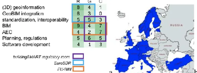
Figure 1a describes the field of expertise covered by the participants to the network so far, associated to the kind of represented institution or stakeholder. A good distribution would mean having the necessary skills and points of view covered. The scope of main activities of the participants to the network is also there reflected. Within the ‘Research’ field (R), both universities and other kinds of research centres are intended; ‘Government’ (G) includes Ministries, Municipalities and other public organisations, such as many National Mapping and Cadastral Agencies (NMCAs); ‘Companies’ (C) regards the world of private enterprises. In addition, the scope of the three international organisations supporting the network: EuroSDR, buildingSMART regulatory room and the EU-BIM task group, are mapped, showing how their interests intersect with the network ones. Moreover, the European countries represented in the network are mapped in Figure 1b.
34https://3d.bk.tudelft.nl/projects/eunet4dbp/
a b
Figure 1. a. Occurrences and distribution of EUnet4DBP skills and scope of the involved associations. b. Countries of origin of
network participants. 3.2 The three pillars
Considering the matured experiences, it has been decided to define three main pillars to group the existing issues, formulate related objectives and plan actions for the EUnet4DBP. Other studies defined them previously as, for example:
• Technology – Commercial – Political (CDBB, 2019); • Technology – Process – Competence, having Capabilities
as a centre (Hirvensalo, 2009);
• Technology and applications – information structure and information flow – mentality and culture (people) - organisation and management (Van Berlo et al., 2012). Considering those previous groupings and the outcomes of the developed pilots, three pillars for the EUnet4DBP have been defined as:
• Process – including human practices and bureaucratical workflows to be taken into account and likely changed to adopt the new digital approach;
• Rules and requirements – as formulation of criteria and guidelines to be followed for the successful achievement of the objectives in all the steps and aspects of the use case, including rule interpretation and model preparation; • Technology – regarding any aspect related and allowing
the implementation of the previous ones. 4. THE WORKSHOP
The three pillars were defined in more detail in the EUnet4BDP workshop, where they were used as the base for reasoning about the goals and future action plan of the network.
4.1 Methodology
The EUnet4DBP workshop was an online event hosted by the open source video conference tool Jitzi (https://meet.jit.si/). 24 people coming from 13 European countries participated at the event. The background provided by the participants was various: the 53% of the participants came from Academia, the 18% from Geodata Agency, 12% from Public Authorities, 12% from the Industry and 6% from Standardisation Bodies. The scope of the workshop was to build the vision of the EUnet4DBP. The vision is described by:
• the EUnet4DBP ambitions in a 10 years' time frame; • the EUnet4DBP requirements, needed to achieve the
EUnet4DBP ambitions.
The workshop consisted in three parts. During the first part, lasting from 09:00 am to 12:00 am, selected participants introduced specific aspects related with the digitalisation of the building permit process, BIM and 3D City Models with the aim of providing a common background knowledge to all the The International Archives of the Photogrammetry, Remote Sensing and Spatial Information Sciences, Volume XLIV-4/W1-2020, 2020
participants, in order to start overcoming that discipline-centred view cited in Section 2.3.
The second part of the workshop (12:00 – 13:00) was structured as round tables. The scope of this section of the workshop was to brainstorm a list of ambitions by all the participants for each of the EUnet4DBP pillars (i.e., process, rules and requirements, technology) and the related requirements necessary to reach them. Participants were divided into three groups based on their background in order to have heterogeneous points of view into each group. Each group met separately in a new video conference in Jitzi as a sort of separate room and a moderator was assigned to each group.
For each group, the activity lasted 45 minutes divided into three sessions of 15 minutes each, organized in form of a very structured brainstorming. The moderators guided the activity using the web tool Mentimeter, a web tool which supports the interaction of remote teams with live polls, Q&A and word clouds. session 1 focused on the Technology pillar, for the definition of the ambitions and requirements from the technology point of view; session 2 focused on the Process pillar; session 3 focused on Rules and requirements.
For each session/pillar, the participants were asked to answer to two questions:
• What are your ambitions with respect to this pillar? • What do you think it is currently missing to achieve them? Participants had 1 minute to answer to the question and then, in turn, they had 30 seconds each to present their own answer to the others. During the lunch break (13:00 – 14:00), the moderators met virtually together to elaborate the results of the groups work activity. The elaboration consisted in grouping similar answers and, consequently, coding them in order to define clusters of answers. Back to one single virtual room, the third part the workshop (14:00 – 15:00) was focused on sharing the results of the previous activity in a structured discussion, whose aim was to lead to the definition of the EUnet4DBP roadmap and of the EUnet4DBP action plan. One of the moderators presented the list of the Ambitions and of the Requirements for each pillar, as a result of the previous activity. The results from the groups work activities were, in fact, used as the basis to start another data collection session with the aims to (1) prioritize ambitions and requirements; (2) evaluate the benefit-effort ratio for each ambition and requirement according to opinion and experiences of the members of the network participating to the workshop. With the support of Mentimeter, the moderator asked the participants:
• to express their opinion about the amount of years (from a minimum of 1 to a maximum of 10 years) needed to achieve each ambition;
• to express their opinion about the amount of effort (from a minimum of 1 to a maximum of 10) required to have each requirement satisfied, together with the amount of benefit (from a minimum of 1 to a maximum of 10) produced by the satisfaction of each requirement.
Finally, the workshop concluded asking the participants to describe, via Mentimeter, each pillar in three keywords. The scope was to sum up all the discussions held during the event in a word cloud visualization, which will represent the principles driving the EUnet4DBP activities in the next future.
The workshop was followed by a post processing phase of the data collected during the workshop. In particular, all the data
exported from Mentimeter were uploaded in an excel sheet, to allow further analysis and to synthetise the results.
Firstly, the post processing phase focused on classifying the ambitions in: short-term, medium-term and long-term. The short-term ambitions as those achievable in a time frame of 1 to 3 years, the medium-term ambitions in 4 to 6 years and the long-term ambitions in 7 to 10 years. Then, the post processing of the effort-benefit analysis for the requirements led to a prioritization of the requirements. Results of the workshop are visualized in a X(=effort)-(benefit) graph. The graph is divided in 4 four quadrants: the requirements located in the low effort – high benefit quadrant are considered as the ones with the highest priority followed by the requirements located in the low low benefit quadrant, the ones located in the high effort-high benefit quadrant and the ones located in the effort-high effort-low benefit quadrant.
The last step of the post processing phase consisted in a qualitative analysis of the word clouds: the results obtained using Mentimeter were imported in NVivo, a tool for the analysis of qualitative data. A word frequency query was run for each pillar of the network based on the results obtained in the last part of the workshop in order to post-process the word clouds developed in real time during the meeting. Word frequency queries are usually adopted to identify meaningful patterns and they are run on one or more text files after setting some criteria. Words have been grouped in families of similar words and terms (e.g., communicate, communication). Finally, the results of the queries can be interpreted and visualised in the form of word clouds, a representation that can be used to obtain an immediate view of some trends.
4.2 The workshop outcomes
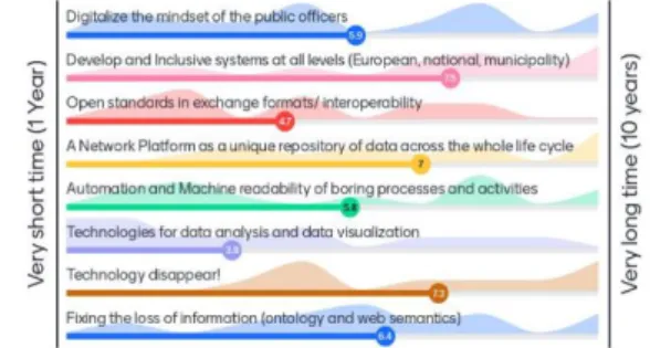
This section shows the outcomes of the workshop as represented in Mentimeter. Figures 2-4 show an example of the obtained outcomes regarding the Technology pillar, full results are available in the website35.
Figure 2. Ambitions for Technology in a 10 years' time frame.
Figure 3. Effort-Benefit of Requirements for Technology.
35https://3d.bk.tudelft.nl/projects/eunet4dbp/img/2-Digital-29-05-2020/Results.pdf
The International Archives of the Photogrammetry, Remote Sensing and Spatial Information Sciences, Volume XLIV-4/W1-2020, 2020 3rd BIM/GIS Integration Workshop and 15th 3D GeoInfo Conference, 7–11 September 2020, London, UK
Figure 4. Word cloud for Technology. 4.3 Post processing results
The main results of the post processing analysis are: • the Principles guiding EUnet4DBP activities and plans. • the Ambitions that the EUnet4DBP intends to achieve and
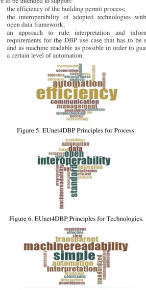
the Requirements needed to achieve those Ambitions. 4.3.1 The principles guiding the EUnet4DBP pillars. Based on the interpretation of the resulting word cloud, it is possible to say that all the EUnet4DBP actions and deliverables have to be intended to support:
• the efficiency of the building permit process;
• the interoperability of adopted technologies within an open data framework;
• an approach to rule interpretation and information requirements for the DBP use case that has to be simple and as machine readable as possible in order to guarantee a certain level of automation.
Figure 5. EUnet4DBP Principles for Process.
Figure 6. EUnet4DBP Principles for Technologies.
Figure 7. EUnet4DBP Principles for Rules and Regulations. 4.3.2 The EUnet4DBP Ambitions. Short-term Ambitions are:
• Create use cases and good practice – Process, Rules and requirements;
• Develop technologies for data analysis and data visualization – Technology;
• Calculate the % of rules that can be automated – Rules and requirements;
• Develop a regulatory framework: how to organize information and requirements – Rules and requirements. Medium-term Ambitions are:
• Capture and manage process definitions in a visual mode – Process;
• The process steps should contain different spatial and semantic data – Process;
• Simplify the building permit process as much as possible – Process;
• Align the process at EU level – Process;
• Automated and Machine-readable process – Process, Technology, Rules and Requirements;
• Open standards in exchange formats – Technology; • Digitalize mindset of the public officers – Technology; • Fix the loss of information – Technology;
• A network platform as a unique repository of data across the whole life cycle – Technology;
• Empower public officers – Rules and requirements; • Simple and clear rules, clear specification of the
requirements – Rules and requirements;
• Fix the LOD / LOIN / LOG issue – Rules and requirements.
Long-term Ambitions are:
• Very high technology readiness level – Technology; • Develop an inclusive system at all level (European,
national, municipality) – Technology;
• Everything is machine readable – Rules and requirements. It emerges that most of the short-term ambitions are related to the Rules and requirements pillar, while Technology cover most of the long-term ambitions (Figure 8).
Figure 8. Classification of the EUnet4DBP Ambitions. 4.3.3 The EUnet4DBP Requirements. In this section the authors report the list of the requirements with the highest priority, which means the ones located in the low effort - high benefit quadrant of the X-Y graph. These represent the essential conditions to reach the ambitions listed above. Moreover, requirements are listed without a reference to the three pillars (as for the Ambitions) since it emerged that many of them are valid for more than one pillar.
Requirements with the highest priority:
• Understanding the necessary process steps; • Create motivation towards open data. Requirements with a high priority:
The International Archives of the Photogrammetry, Remote Sensing and Spatial Information Sciences, Volume XLIV-4/W1-2020, 2020 3rd BIM/GIS Integration Workshop and 15th 3D GeoInfo Conference, 7–11 September 2020, London, UK
• Collaboration between software, companies, SMEs and research;
• Exploitation of the existing technologies within the European Recovery Plan;
• Dedication of all players involved;
• Communication about the existing experiences;
• Quantification of the time and costs savings due to a digital process;
• A Roadmap and a change framework towards a fully digital building permit process;
• A consolidated vision where every industry can win; • Fighting the fear;
• Provide recommendation to the EU commission; • Define the problem statement;
• A holistic approach.
• Involvement of computer scientists/gaming and software developers;
• Building business case for technology investments. 5. DISCUSSION AND CONCLUSION
Within the context of the international research related to digital building permit and rule checking procedures, the paper describes the preliminary activities developed by the EUnet4DBP, which is a network of European stakeholders interested in the digital innovation of the building permit process.
Preliminary activities allowed the network to map existing experiences within the network itself in order to evaluate the panel of expertise that can be put on the table to work towards the achievement of ambitions and requirements.
A workshop was organized to specifically define such ambitions and requirements by means of active collaboration. Brainstorming activities and quantitative data collection methods have been organized for such a purpose. A minor note regards the completely digital means that were used in the workshop, as was required by the world emergency status of the first half of 2020, but that revealed to be very effective and will be adopted in following occasions as well, with advantage to amount of participation, time and resource need, and environment.
From the brainstorming session, organized in form of round tables, a list of ambitions and requirements was defined. After the rough data were grouped, the most important topics for the network (and for the digital building permit itself) could emerge. Quantitative data collection methods allowed the prioritization of the ambitions and a preliminary determination of the benefit-effort ratio for each of them, with short-term ambitions to be mainly related to Rules and requirements, followed by Process-related issues and Technological aspects. This result represents an important indication for drafting the roadmap for next research and implementation activities of the network. The 25% of technology-related ambitions are classified as long-term: a deep knowledge, analysis and change in processes and underlying rules and requirements seems to be mandatory before moving towards such an achievement. While such results clearly identify the most relevant points to be put in the agenda, as coming from the fast brainstorming session, the same short time in which they were proposed make them be possibly inaccurate in their formulation; for example, some of them are stated more as actions than ambitions. Therefore, a further improvement could critically re-classify the
obtained answers according to an updated set of categories including actions besides ambitions and requirements. A further refinement and discussion of them will be the next step of the EUnet4DBP.
Other future work could include: analysis according to the type of stakeholder; engagement of a wider panel of stakeholders as well as the analysis of ambitions and requirements from the perspective of each type of expertise (i.e., research, government, companies) in order to compare priorities and effort-benefits previsions based on that.
6. ACKNOWLEDGEMENTS
The authors would like to thank Ordnance Survey GB (www.ordnancesurvey.co.uk) and 1Spatial (www.1spatial.com/) for sponsoring the publication of this paper.
7. REFERENCES
Arroyo Ohori, K., Diakité, A., Krijnen, T., Ledoux, H., Stoter, J., 2018. Processing BIM and GIS Models in Practice: Experiences and Recommendations from a GeoBIM Project in The Netherlands. ISPRS International Journal of Geo-Information,7.
Belliard, R., Shantalle, L., 2016. Implementation of BIM in the Municipal Plan Review Process. Brigham Young University, all
theses and dissertations. 6069.
https://scholarsarchive.byu.edu/etd/6069 Accessed 07/07/2020. Biljecki, F., Stoter, J., Ledoux, H., Zlatanova, S., Çöltekin, A., 2015. Applications of 3D city models: State of the art review. ISPRS International Journal of Geo-Information, 4(4), 2842-2889.
CDBB - Centre for Digital Built Britain, 2019, D-COM: Final Report Digitisation of Requirements, Regulations and Compliance Checking Processes in the Built Environment. Choi, J., Kim, I., 2015. Development of an open BIM-based legality system for building administration permission services. Journal of Asian Architecture and Building Engineering, 14(3), 577-584.
Ciribini, A.L.C., Mastrolembo Ventura, S., Paneroni, M., 2016. Implementation of an interoperable process to optimise design and construction phases of a residential building: A BIM Pilot Project. Automation in Construction, 71, 62-73.
Clayton, M., Fudge, P., Thompson, J., 2013. Automated plan review for building code compliance using BIM. EG-ICE 2013 Workshop, Vienna, Austria.
DCLG - Department for Communities and Local Government, 2015. Plain English Guide to the Planning System.
Eastman, J., Lee, Y., Jeong, L. Lee, 2009. Automatic rule-based checking of building designs, Autom. Constr., 18(8),1011–1033. Fosu, R.; Suprabhas, K.; Rathore, Z.; Cory, C., 2015. Integration of Building Information Modeling (BIM) and Geographic Information Systems (GIS) – a literature review and future needs. Proceedings of the 32nd CIB W78 Conference, Eindhoven, The Netherlands, 27–29.
The International Archives of the Photogrammetry, Remote Sensing and Spatial Information Sciences, Volume XLIV-4/W1-2020, 2020 3rd BIM/GIS Integration Workshop and 15th 3D GeoInfo Conference, 7–11 September 2020, London, UK
Future Insight Group, 2019. Technical report for contract SRSS/C2019/024 -Introducing a Building Information Model (BIM)-based process for building permits in Estonia. https://eehitus.ee/wp-content/uploads/2019/11/2019-07-19-BIM-based-building-permits-Technical-Report.pdf.
Hbeich, E., Roxin, A., Bus, N., 2019. Applying PLU Rules on Different BIM/GIS Interoperability Approaches. Informatica Economică, 23(3/2019), 26-38.
Hirvensalo, A., Kaste, K., Maunula, A., 2009. ECPIP Finland final report: Technology enabled process development in project networks'. Helsinki University of Technology Simlab Publications, Report Series, 24.
Isikdag, U., Zlatanova, S., 2009. A SWOT analysis on the implementation of Building Information Models within the Geospatial Environment. Urban and Regional Data Management, CRC Press, The Netherlands, pp. 15–30
Kang, T.W.; Hong, C.H., 2015. A study on software architecture for effective BIM/GIS-based facility management data integration. Automation in construction, 54, 25–38. Kim, I., Jang, J. and Choi, J., 2016. Development of pre-specification for BIM-based automated building code checking. Korean Journal of Computational Design and Engineering 21(1), pp. 31–41.
Lee, H., Lee, J.K., Park, S., Kim, I., 2016. Translating building legislation into a computer-executable format for evaluating building permit requirements, Automation in Construction. 71, 49–61. https://doi.org/10.1016/j.autcon.2016.04.008.
Liu, X.; Wang, X.; Wright, G.; Cheng, J.C.; Li, X.; Liu, R., 2017. A state-of-the-art review on the integration of Building Information Modeling (BIM) and Geographic Information System (GIS). ISPRS International Journal of Geo-Information, 6, 53.
Malsane, S., Matthews, J., Lockley, S., Love, P.E.D., Greenwood, D., 2015. Development of an object model for automated compliance checking, Automation in Construction, vol. 49, pp. 51-58.
Marzabal Galano, M., 2014. WeBoubesluit. MSc thesis, Inholland University of Applied Sciences - Building Management & Real Estate, Haarlem, The Netherlands. Noardo, F., Ellul, C., Arroyo Ohori, K., Biljecki, F., Harrie, L., Krijnen, T., Stoter, J., 2020a. The ISPRS-EuroSDR GeoBIM benchmark 2019. ISPRS- Int. Arch. Photogramm. Remote Sens. Spatial Inf. Sci.- Proceedings of XXIV ISPRS Congress. ISPRS. Noardo, F., Wu, T., Arroyo Ohori, K., Krijnen, T., Tezerdi, H., Stoter, J., 2020a. GeoBIM for digital building permit process: learning from a case study in Rotterdam. ISPRS- Int. Arch. Photogramm. Remote Sens. Spatial Inf. Sci. - Proceedings of the 15th 3DGeoinfo Conference 2020, London.
Noardo, F., C. Ellul, C., Harrie, L., Overland, I., Shariat, M., Arroyo Ohori, K., and Stoter, J., 2020b. Opportunities and challenges for GeoBIM in Europe: developing a building permits use-case to raise awareness and examine technical interoperability challenges. Journal of Spatial Science. 65(2), 209-233. doi:10.1080/14498596.2019.1627253.8207.
Olsson, P.O., Axelsson, J., Hooper, M., Harrie, L., 2018. Automation of Building Permission by Integration of BIM and Geospatial Data. ISPRS International Journal of Geo-Information, 7, 307.
Olsson, P. O., Johansson, T., Eriksson, H., Lithén, T., Bengtsson, L.-H., Axelsson, J., Roos, U., Neland, K., Rydén, B., and Harrie, L., 2019. Unbroken digital data flow in the built environment process – a case study in Sweden, Int. Arch. Photogramm. Remote Sens. Spatial Inf. Sci., XLII-2/W13, 1347–1352, https://doi.org/10.5194/isprs-archives-XLII-2-W13-1347-2019.
Plazza, D., Röck, M., Malacarne, G., Passer, A., Marcher, C.and Matt, D., 2019. BIM for public authorities: Basic research for the standardized implementation of BIM in the building permit process. IOP Conference Series: Earth and Environmental Science. 323(1), IOP Publishing, p. 012102.
PricewaterhouseCoopers Advisors – PwC, 2019. Mapping, optimizing and adjusting for the introduction of e-construction of the procedures of the Register of Buildings – Final report
https://eehitus.ee/wp-content/uploads/2019/07/MKM_PwC_EHR_optimizing_Regist er_of_Buildings_final_report_ENG.pdf (Access on 07/07/2020) Samasoni, J., Rotimi, J., 2014. An exploratory evaluation of a new national online consenting system in New Zealand. 14th International Conference on Construction Applications of Virtual Reality in Construction Conference on Islamic Architecture held at Sharjah, UAE, 2014-11-16 to 2014-11-18. http://hdl.handle.net/10292/9746 (Accessed on 07/07/2020). Siew, R. Y., Balatbat, M. C., Carmichael, D. G., 2013. A review of building/infrastructure sustainability reporting tools (SRTs). Environment, 2(2), 106-139.
Solihin, W., Eastman C., 2015. Classification of rules for automated BIM rule checking development. Autom. Constr., 53, pp. 69-82 http://doi.org/10.1016/j.autcon.2015.03.003
Solihin, W., Dimyadi, J., Lee, Y., Eastman, C., Amor, R., to be published in September 2020. Simplified schema queries for supporting BIM-based rule-checking applications, Automation in Construction, Vol. 117, 2020.
Sun, J., Mi, S., Olsson, P., Paulsson, J., Harrie, L., 2019. Utilizing BIM and GIS for Representation and Visualization of 3D Cadastre. ISPRS International Journal of Geo-Information, 8, 503.
Swaddiwudhipong, S., Kog Y.C., 2000. IT strategy of the Singapore construction sector. Computing in Civil and Building Engineering, pp. 635-642, doi: 10.1061/40513(279)83.
Van Berlo, L. A. H. M., Dijkmans, T., Hendriks, H., Spekkink, D., Pel, W., 2012. BIM QuickScan: benchmark of BIM performance in the Netherlands. In Proceedings of the CIB W78 2012.
Van Berlo, L. A. H. M., Dijkmans, T., Stoter, J. E. 2013. Experiment for integrating Dutch 3D spatial planning and BIM for checking building permits. ISPRS- Int. Arch. Photogramm. Remote Sens. Spatial Inf. Sci. - 8th 3DGeoInfo Conference & WG II/2 Workshop, Istanbul, Turkey, 27–29 November 2013, II-2/W1.
The International Archives of the Photogrammetry, Remote Sensing and Spatial Information Sciences, Volume XLIV-4/W1-2020, 2020 3rd BIM/GIS Integration Workshop and 15th 3D GeoInfo Conference, 7–11 September 2020, London, UK