L
ucaMilanesi
(*), M
arcoPilotti
(*), a
LbertoCleriCi
(*)& Z
oranGavriloviC
(**) (*)Università degli Studi di Brescia - DICATAM - Via Branze, 43 - 25123 Brescia, ItalyE-mail: [email protected] - [email protected] - [email protected]
(**)Institute for the Development of Water Resources “Jaroslav Černi” - Jaroslava Černog, 80 - 11226 Beograd, Serbia - E-mail: [email protected]
APPLICATION OF AN IMPROVED VERSION
OF THE EROSION POTENTIAL METHOD IN ALPINE AREAS
la valutazione dei processi erosivi e delle loro conseguenze riveste un ruolo fondamentale nella corretta gestione del territorio; gli ambiti d’interesse sono relativi alla fruibilità del suolo, inteso come risorsa ambientale ed economica, all’assetto idrogeologico e, non da ultimo, alle interazioni con numerose opere di ingegneria tra cui spiccano gli invasi ed i manufatti di derivazione. Per queste ragioni si rivelano di grande interesse applicativo le metodologie per la stima del contributo solido di un bacino idrografico ad oppor-tune scale spaziali e temporali.
nel presente contributo si considera un modello empirico, il Metodo dell’erosione Potenziale (GavriLovic, 1988), che fornisce indi-cazioni a scala annua sul volume di suolo eroso e trasportato alla sezione di chiusura di un bacino. si propone una revisione organica di alcuni dei suoi criteri di parametrizzazione e delle modalità di implementazione. in particolare, al fine di garantire maggiore semplicità ed oggettività alla fase di stima dei valori dei parametri sul bacino, si è inteso riconsiderare le modalità di classificazione dell’uso del suolo e delle caratteristiche geomeccaniche dei terreni e delle rocce tramite schemi largamente diffusi nella comunità scientifica (e.g., Corine 2000 per la descrizione degli usi del suolo). si propone inoltre di limitare il periodo d’applicazione, originariamente a scala annua, ai soli periodi in cui le temperature, le caratteristiche delle precipitazioni e le portate sono tali da garantire l’effettivo innesco dei processi di erosione ed il trasporto del materiale nei corsi d’acqua. Questo approccio permette quindi di superare alcune difficoltà legate alla soluzione delle equazioni che compongono il modello estendendone quindi l’applicabilità anche a zone con temperatura media an-nua negativa, che caratterizzano ad esempio i bacini alpini d’alta quota. applicando il modello sia secondo la metodologia originaria che implementando le modifiche proposte, sì è potuto osservare che queste non alterano le stime di produzione di sedimento ma aumentano significativamente l’oggettività dei risultati e la semplicità di applicazione dello schema.
si propone inoltre una analisi statistica sull’opportunità dell’applicazione del modello in forma distribuita piuttosto che a parametri concentrati. sebbene l’applicazione a parametri concentrati risulti generalmente più semplice, l’implementazione distribuita del mo-dello tramite opportuni codici di calcolo permette di cogliere maggiormente le specificità locali del bacino; le differenze conseguenti ai due diversi approcci metodologici possono raggiungere il 14%. si è infine testata l’effettiva applicabilità del modello e delle modifiche proposte in ambiente alpino, per il quale esso non era stato originariamente derivato. il modello è stato applicato in forma distribuita a 31 bacini in alta valtellina (sondrio - italia) le cui acque sono convogliate per lo sfruttamento idroelettrico negli invasi di san Giacomo di Fraele, Cancano e val Grosina. sulla base delle informazioni fornite dal gestore degli impianti, è stato possibile ricostruire il volume di sedimento, quasi esclusivamente composto da limo glaciale, attualmente raccolto negli invasi dopo circa 50 anni di esercizio. al fine di rendere omogenee le stime del modello, che comprendono l’intero spettro granulometrico, e le informazioni di interrimento dei baci-ni, che invece riguardano la sola frazione fine, si è provveduto ad eseguire una serie di campionamenti dei terreni dei bacini studiati ed effettuare analisi granulometriche volte a definire la percentuale di materiale fine che costituisce i sedimenti. tramite questa procedura è stato quindi possibile stimare il volume di materiale fine che annualmente viene eroso in ciascun bacino e convogliato in sospensione nei corsi d’acqua fino agli invasi e confrontare positivamente le informazioni di interrimento con i risultati del modello.
in conclusione, questo studio propone modifiche sostanziali nelle tabelle e nelle modalità di implementazione del modello senza influire tuttavia sulle relazioni, sulle ipotesi di base e sui risultati. la fase applicativa mostra che le stime fornite dal metodo, sebbene affette da significative soglie di incertezza peraltro insite in questo tipo di fenomeni, sono sostanzialmente in buon accordo con le os-servazioni di lungo periodo sull’interrimento dei serbatoi.
AbSTRACT
the assessment of erosive processes is of great importance in environmental engineering, resource management and land planning. in this paper the empirical approach known as erosion Potential Method (EPM) was improved to simplify the identifi-cation of the involved parameters. in addition, EPM suitability for alpine watersheds, where the average yearly temperature may be below 0°C, was discussed. the advantages of distributed ap-proaches rather than lumped methodologies were tested. EPM was then implemented in a distributed form for a set of 31 catch-ments located in alta valtellina (northern italy) in order to cap-ture the spatial variability of the parameters and the intensity of the erosion processes. the results obtained for these catchments were positively compared to long-term sedimentation data from three reservoirs and from a turbidimetric station.
Keywords: erosion potential method, soil erosion, Alpine reservoirs se-dimentation
INTRODuCTION
sediment supply of rivers is a consequence of a wide set of distributed erosion phenomena acting in a watershed. the evolu-tion of such processes might be slow (e.g., freeze-thaw acevolu-tion and growth of plant root system in rock joints, chemical weath-ering processes like hydrolysis and oxidation) or characterized by a greater velocity (e.g., soil creep, rill and gully erosion) and even by a very high velocity (e.g., some kind of landslides, debris flows). as a result, the volume of involved materials might be relevant and the effects are usually of primary importance both in the field of environmental engineering and of agriculture. it has been reckoned that almost 1.2 kg/m2 of soil per years are lost in intensive agriculture areas in the Usa as a consequence of wa-ter and wind erosive capacity (u.S. DepartMentof aGricuLture, 2009). in addition, sediments are an important source of pollu-tion for water bodies both in terms of turbidity and of nutrients. Finally, the settling of sediments in reservoir may cause important related problems, such as the reduction of their storage capacity (vanoni, 1975), damages to electromechanical machinery (pipes and turbines) and potential impairment of the properties of drink-ing water. For instance, about 30% of the original italian storage volume is now occupied by sediments (itColD, 2009) and this fraction is about 35% worldwide (baSSon, 2010).
the importance of the consequences of soil erosion prompts continuous research for effective methodologies to quantify soil loss in catchments. to this purpose, different approaches might be identified in the literature. Hydraulic modelling focuses on the transport capacity of the river through the calibration of sedi-ment transport formulae at the local level. these relations are generally obtained through laboratory experiments under the hy-pothesis of infinite sediment availability, steady,
two-dimension-al and uniform flow (e.g., Graf, 1971; YaLin, 1977; rauDkivi & tan, 1984; SiMonS & Sentürk, 1992). the distribution of the suspended fraction is usually computed through additional con-siderations about turbulence and sediment concentration along the vertical direction. From this point of view, the estimate of the mean annual sediment transport volume may be performed by time integration using the flow duration curve of the studied stream. a possible criticism to this approach regards the inter-mittency of the actual sediment transport, which, also in steady flow conditions, is controlled by the sediment availability and is triggered by intense hydrologic events. this is particularly true in mountain areas, where most of the sediment production occurs during few strong events because of the strengthened carrying capacity of the flow and the increased availability of sediments into the streambed (e.g. pitLick & thorne, 1987). accordingly, conceptualized approaches to assess the overall relevance of sediment production at the basin scale are justified.
the catchment-wide soil erosion models available in the lit-erature can be classified according to their conceptual features and different space and time scales of application (e.g., De vente & poeSen, 2005). Moreover, some of these models were devised to estimate soil loss for specific purposes only (e.g., agricultural conservation) while others have a wider scope, with possible applications in land planning, river restoration and reservoir management. the choice of the most suitable model depends on the goal of the application, on the reliability of the model for the specific morpho-climatic environment (e.g., arid/semi arid landscapes, mountainous regions, agricultural lands) and finally on the available data. Physically based, conceptual and empiri-cal methodologies can be found in the literature (e.g. Merritt
et alii, 2003). Physically based models provide a mechanistic
description of erosive processes through fundamental conserva-tion principles and constitutive equaconserva-tions. these methods assess the interaction of each element and return the variation of sedi-ment production in space and time, usually requiring a consider-able amount of input data and of computational effort (ranZi
et alii, 2012). among others, the widespread models CreaMs,
Kineros, eUroseM, liseM and WePP might be cited (e.g., nearinG et alii, 1989; De roo et alii, 1995; SMith et alii, 1995; braZier et alii, 2000). Conceptual models may be regarded as a compromise between empirical and physically based models because they link conservation equations to empirical relation-ships. Finally, empirical formulae describe the phenomena in a simplified way through regressive relations of experimental data that link together the most statistically relevant parameters. Due to their simplicity, the use of empirical methodologies is widely documented in the literature. indeed, despite a simple formal structure, they usually provide a valuable engineering approach to soil erosion estimate if used into the same geomorphological environment where they were calibrated. among others the
fol-lowing models might be cited: Usle and further revisions for agricultural areas (WiSchMeier & SMith, 1978); PsiaC for arid and semi arid regions; denudation index based on geomorphic parameters for badlands (e.g., DeLLa Seta et alii, 2009).
among empirical methodologies, the erosion Potential Method (GavriLovic, 1988), in the following also indicated as “EPM”, is a semi-distributed model for the estimation of the mean annual soil erosion and sediment yield at the basin scale. Despite its original formulation, applications at a smaller time step can be found in the literature (e.g., beMporaD et alii, 1997) as well as space-distributed implementations that better account for the local variability of the involved parameters (De ceSare et
alii, 1998; eMManouLouDiS et alii, 2003; GLobevnik et alii, 2003; tanGeStani, 2006; boZorGZaDeh & kaMani, 2012; baGherZaDeh & DaneShvar, 2010). these improvements take advantage of the development of digital cartography and Gis technologies.
although EPM was calibrated using laboratory and field data for the Dinaric alps, several literature contributions test the applicability of EPM in different climatic areas. For instance, several researches assess the suitability of EPM to semiarid Mediterranean regions (e.g., eMManouLouDiS et alii, 2003; eM -ManouLouDiS & kaikiS, 2006; tanGeStani, 2006; SoLaiMani et
alii, 2009; boZorGZaDeh & kaMani, 2012) and to the alpine and appenninic area (e.g., poZZi et alii, 1990; Mikoš et alii, 2006; fanetti & veZZoLi, 2007; taZioLi, 2009; Zorn & koMac, 2009). anyway, the original form of EPM cannot be applied in areas characterized by mean annual temperature below -1°C because of the definition of the temperature coefficient.
another major stumbling block that hinders the widespread application of EPM arises from its parameterization tables, whose original definitions are sometimes of difficult interpre-tation and generalization. Hence, the reliability of the results might be significantly affected by the user’s experience. to limit these effects, improving the reliability of the results and reduc-ing the influence of users’ know-how, many authors suggested modifications to the EPM tables (Stefanović et alii, 2010; bo -ZorGZaDeh & kaMani, 2012; toSic & DraGicevic, 2012). How-ever these efforts have not delivered a complete and easy-to-use revision of the original classification.
this paper deals with these limitations of EPM: the model was applied to a cold alpine environment by suggesting a modification of the original temperature parameter and the classification tables were revised on the basis of widespread classification methodolo-gies (e.g. Corine land Cover for land use factor). this greatly sim-plifies the application of the model by increasing the objectivity of parameters definition. Moreover, a procedure for the distributed ap-plication of the methodology is presented and its actual advantages are briefly discussed. the model was applied to 31 alpine catch-ments in alta valtellina (northern italy) and the results were posi-tively compared to measured sedimentation and turbidimetric data.
THE EROSION POTENTIAL METHOD
EPM is an empirical formula that supplies the mean annual
vol-ume of sediments eroded and the fraction yielded to the outlet of a river basin. erosive phenomena arise from the interaction of litho-logical, topographic, climatic and land use quantities (e.g., fournier, 1960; MorGan, 1979) that in this model are linked by the relation:
where Wsp (m3/km2) is the specific mean annual production of sediment and P (mm) represents the mean annual cumulative rainfall. With reference to the latter, Zorn & koMac (2009) high-lighted some modifications introducing the maximum daily rain-fall in order to make the model able to account also for extreme events which otherwise would not be considered (e.g., Mikoš et
alii, 2006). the temperature coefficient t (-) is calculated as:
where t (°C) represents the mean annual temperature. the param-eter Z (-) is defined as:
where X (-) describes the protection by vegetal or artificial cover-age against erosive factors and is a function of land use; Y (-) rep-resents soil resistance against water erosive capacity and is a func-tion of the basin lithological and pedologic features; φ (-) indicates the intensity of the active erosion processes; i (m/m) is the mean slope of the investigated area, that can be calculated through an area-weighted average. the mean annual sediment yield G (m3/y) at the outlet accounts for the actual transport capacity of the flow:
G= W · R = W
sp · F · R
where the retention coefficient R (-) represents the percentage of sediments that reaches the outlet, W (m3/y) is the volume of erod-ed serod-ediment and F (km2) the area of the river-basin. accordingly, eq. (4) reflects the possible reduction of transported sediments along the watercourse due to the local decrease of bed shear stress. GavriLovic (1988) suggested to compute R as:
where O (km) is the perimeter of the catchment, ΔĤ (km) the mean geodetic relief and L (km) the linear dimension of the catch-ment along the main channel. on the basis of further studies in al-pine areas, ZeMLjic (1971) observed that eq. (5) tends to overrate the effective ratio between eroded and yielded sediments. some-times it may even return unphysical values larger than 1. Hence, ZeMLjic (1971) suggested the following relation:
where Ĥ (km) indicates the mean altitude of the basin and Li (km)
represents the length of ith order channels. equation (6) was used
in this paper. (1) (2) (3) (4) (5) (6)
IMPROVEMENTS TO EPM
in this section some modifications to EPM are proposed in order to cope with the problems arising in the identification of its parameters and in the application in cold mountain areas. the application of eq. (2) in alpine areas with mean annual tempera-ture below -1 °C, is not possible because of the negative value of the radical. However, in these areas, erosion processes are mostly concentrated in the period from spring to fall, (e.g., De ceSare et alii, 1998), because in winter period both the soil and
the streams are usually frozen and the snow precipitations have no erosive power. indeed, although freeze-thawing cycles gen-erate sediments and snow avalanches might convey significant amount of sediments only if the sliding plane coincide with the soil layer, in average terms the most effective sediment trans-port processes are related to rainfall and stream waters. accord-ingly, it seems reasonable to apply EPM during the active ero-sion period only, computing the averaged temperature and the cumulative rainfall on such temporal window instead of using
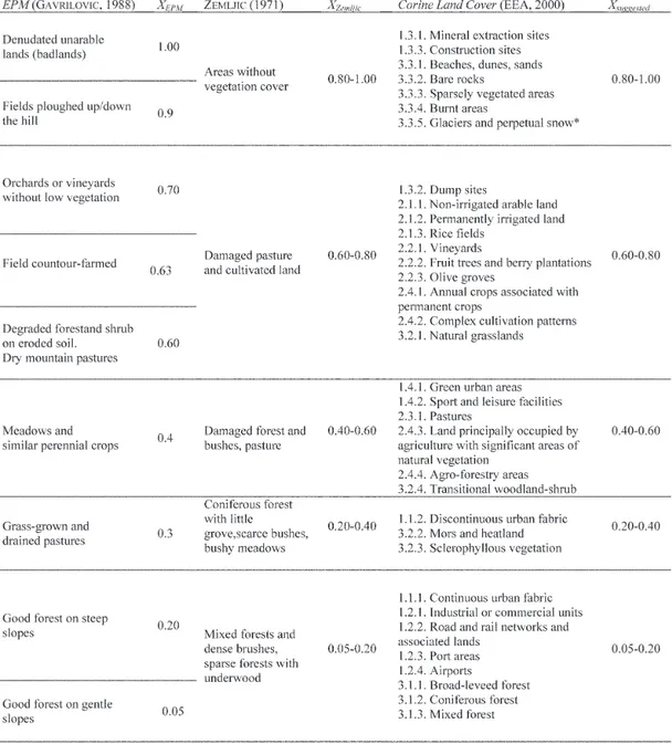
Tab. 1 - Values of the land cover parameter X
* Glaciers and perpetual snow, although protecting soil against rainfall erosivity, exert a relevant erosive action due to meltwaters. Accordingly, in order to cope with this ambiguity, these elements are associated to the maximum value of X, that would mean the lowest protection against erosion
the mean annual values. in this way it is possible to apply EPM also in regions characterized by periods with average tempera-ture below zero.
in order to simplify the assessment of EPM coefficients in eq. (3), reducing ambiguities in the parametric description of the catchment, we propose a systematic correspondence between the original classification tables and some widespread classification systems of land use, geology and active erosion processes. this task was already attempted to a more limited extent by other re-searchers (e.g., eMManouLouDiS et alii, 2003; GLobevnik et alii, 2003; fanetti & veZZoLi, 2007), who related the original EPM classification table of the parameter X to the Corine Land Cover classes (eea, 2000). the Corine Land Cover system represents a reference point at the european level and its maps are freely available in digital format on the web, fostering space-distributed
GIS applications.
the analysis of the analogies between the elements of the original parameterization by GavriLovic (1988) and ZeMLjic (1971) and the categories of the Corine Land Cover system sug-gests the correspondence proposed in tab. 1.
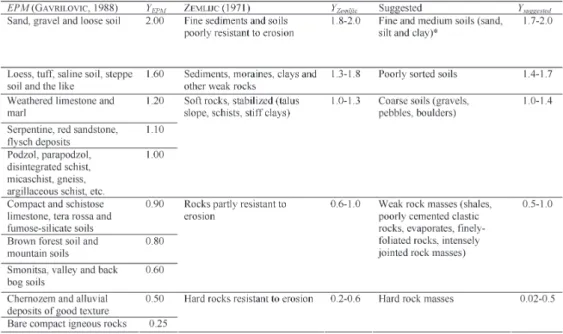
the coefficient Y describes soil erodibility as a function of rock and soil properties (tab. 2). the main goal of the re-classifi-cation of this parameter is to substitute the original classifire-classifi-cation, where geological and geomorphological characteristics of the de-posits were mixed together, with a more systematic one where soils and rocks are divided in two distinct categories. soils are classified on the basis of the particles size and rocks are subdi-vided according to their mean mechanical characteristics.
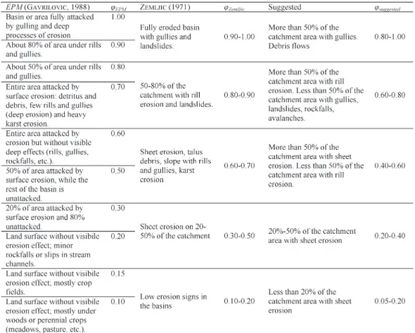
the parameter φ, describing the intensity of the active erosion processes, can be calculated by two distinct procedures. the first approach is based on the general overview of the study area and returns a measurement of the intensity of erosion processes at the river basin scale. this study provides a simplified subdivision and includes some intensive erosion landforms not comprised in the original classification tables (tab. 3).
alternately, a more detailed approach for the assessment of φ goes through the V/F ratio, where V is defined as:
where Fi% (-) represents the percent area covered by the ith
ero-sion landform and Fi (km2) indicates the surface covered by the
ith erosion landform. the weight of each erosive type, P i (-), is
given in tab. 4. the parameter φ is finally provided by tab. 5 as a function of the ratio V/F.
VALIDATION OF THE MODIFIED VERSION OF EPM
in order to compare the improved and the original EPM for-mulations, they were both tested in two small alpine catchments in alta valtellina (northern italy) using a lumped approach. al-though the most effective comparison would have been with re-spect to the same environment of calibration of EPM, the model was partly calibrated using laboratory tests and experimental plots, so that the original data are not relevant for implementation at the basin scale. Moreover, tests in the Dinaric alps would not allow to verify the effect of the modifications provided to cope with negative temperatures.
Tab. 2 - Values of the erodibility parameter Y
* In order to avoid excessive refinement of the classification, fine soils are grouped in a single class although it is well known that clayey soils are less erodible than sandy ones. Accordingly higher values of Y are associated to sand and prevailing sandy soils
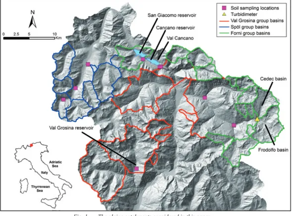
the first test case regards val Cancano, a small catchment (3.8 km2) on the left side of the Cancano reservoir (Fig. 1). the input data and the results provided by the original methodology, based on ZeMLjic (1971) tables, were obtained by QuintavaLLe (2004). it is important to remark that the study by QuintavaLLe (2004) used a parameterization based on yearly averaged quanti-ties, while the current study is based on the modified formulation, that makes use of the cumulative precipitation and of the aver-age temperature for the period (from May to october) when the average temperature is positive. as shown in tab. 6, the results obtained from the two different formulations of EPM are in good agreement. accordingly, it is possible to state that the new param-eterization and the introduced variations on thermal and rainfall coefficients have no relevant effects on the results but simplify the applicability of the model, widening its scope to cold regions. the relevant difference on the active erosion coefficient might be partly explained by considering that we applied the procedure based on eq. (7), while QuintavaLLe (2004) used tab. 3.
the second test case regards the Cedec creek basin (Fig. 1) and focuses only on the effect of the introduced variations to the parameterization tables. this watershed has an area of 17.3 km2 and a mean slope of 42.5%. the results obtained with the
modi-Tab. 4 - Values of the parameter Pi describing the active erosive proc-esses in the catchment
Tab. 5 - Values of the parameter φ describing the active erosion proc-esses in the basin
fied EPM were compared with those by baSSi (2000), obtained on the basis of ZeMLjic (1971) tables, in order to test the influence of the modified tables only. in order to obtain fully comparable results independent from the extent of the simulation period, we used the same average yearly temperature and cumulative pre-cipitation (1145 mm) introduced by Bassi. in order to cope with the negative value of the radical in eq. (2) in a situation where the actual average yearly temperature of the basin would be -1.3°C, baSSi set this value to 0°C. Moreover, he considered X equal to 0 for the glacier area, a low value that would reflect the protec-tion exerted by ice to soil and rocks. although the erosive effect
usually exerted by glacial meltwaters could lead to much higher values of X (see also tab. 1), in this test case we assumed a ficti-tiously low value of X for glaciers as done by baSSi, in order to keep constant this term of the problem and obtain directly com-parable results. Finally, one could observe that this assumption lead to an underestimation of the sediment volume since the role of glaciers is completely neglected. tab. 7 shows that the results provided by the modified version of EPM approximate properly the ones based on the original classification tables. indeed, in this kind of complex problem covering a large basin, a 20% error in the evaluation of sediment volume might be regarded as a good
Fig. 1 - The alpine catchments considered in this paper
Tab. 6 - Parameters and results for the Val Cancano test case, according to the original and the modified EPM versions
result, although the lack of literature data (e.g., boarDMan, 2006) does not allow statistical analyses and confirmations. Hence, the modified parameterization tables do not affect significantly the results of the original procedure and simplify the application of the model, fostering its automated implementation.
COMPARISON bETwEEN LuMPED AND DISTRI-buTED MODELLING OF EPM
the spatial scale of application of erosion models is a rel-evant aspect that controls the physical meaning of the input data and, accordingly, the quality of the results. in particular, there is often the need to preserve the original spatial distribution of the parameters at the slope (parcel) scale (in the order of 103 m2), while providing results at the basin scale (in the order of 106 m2). in a strongly non-linear process like sediment erosion, there is no guarantee that the use of space-averaged parameters leads to an outcome similar to that provided by the space averaging of the re-sults obtained at the local scale. in addition, the averaged param-eters at the basin scale may lose their original physical meaning. the EPM parameters were defined through parcel observa-tions (GavriLovic, 1988), but its practical application is often for large catchments (e.g., GavriLovic, 1988; eMManouLouDiS et
alii, 2003; taZioLi, 2009). in order to find a compromise between these two scales, EPM is usually applied in a semi-distributed fashion, according to which the catchment is subdivided into geo-morphologically and climatologically homogeneous units. in this direction, the use of automated computational procedures, along with geomorphological surveys, is mandatory and in the follow-ing we shall make use of the geomorphological information
con-tained within the space filling drainage network of a basin to deal with EPM computation.
Considering the control exerted by the topography on the movement of water within a catchment, it is not surprising that over the last decades a great effort has been done to couple quantitative geomorphology and hydrology. in this perspective the use of Digital terrain Models (DTM) has become a well es-tablished practice for the extraction of topologic and geomor-phological information. typically, DTM have been used for the computerized extraction of the connected space filling drainage network (SFDN) and of the channel network (CN). the first one is the set of all local flow directions for the physically based simulation of runoff processes and the second one is the sub-set of SFDN where free surface flow takes place, to be used for flood routing within a river basin. Considering that both bedload and washload depend on water erosive and transport capacity, which are a function of local properties (e.g., the local slope) but also of integrative properties of the locally drained catchment, as already proposed by ciccacci et alii (1986), piLotti & bacchi (1997) computed the sediment yield from a catchment exploiting the informative content of SFDN and CN.
the scale gap between parcel and basin information can be filled by taking advantage of the powerful reorganization of the
DTM informative content accomplished by the SFDN and the CN
as described by piLotti et alii (1996). to this purpose, an exten-sive automatic DTM pre-processing can be used, in order to filter depressions and flat areas that would prevent the identification of the drainage network. then, using this enhanced information, the steepest directions can be identified and the SFDN derived. By filtering the SFDN on the basis either of a fixed threshold contrib-uting area principle (o’caLLaGhan & Mark, 1984; banD, 1986, 1993) or of a slope dependent critical support area (MontGoMerY & Dietrich, 1992; MontGoMerY & foufuLa-GeorGiou, 1993), the
CN can be extracted (Fig. 2). Finally, the hillslope drainage
net-work is obtained by logical subtraction of the CN from the SFDN. the networks allow a complete reorganization of the infor-mation contained within the DTM, using non-binary logical tree structures that can be effectively explored by so-called “visiting” recursive algorithms. the use of such procedures allows to com-pute locally eq. (1), moving from link to link within the SFDN and following the same order that would be followed by runoff on the terrain. at each cell, these algorithms operate on data com-puted locally from the DTM (e.g., local slope and temperature) and on raster data made available by the user (e.g., soil properties and land use). at the same time, they take memory of the integra-tive properties that are a function of the upstream explored cells (e.g., the local discharge or the overall drained area).
in order to test the advantages of distributed versus lumped approaches in this problem, a set of seven basins, with area F ranging from 1 to 110 km2 and described by a DTM of constant
Fig. 2 - The cumulative EPM sedimentogram, computed in a distrib-uted fashion along the drainage network, is represented on the DTM and then superimposed to the Space Filling Drain-age Network (SFDN; thin solid lines) and Channel Network (CN; thick solid lines)
cell size of 20 m, were studied. the parameters X, Y, φ and i were assumed to be randomly distributed in space according to a normal distribution law. after computing the average param-eter values, EPM was applied in both lumped and distributed forms. the percentage variations Δ between the results obtained from the two approaches were computed, progressively increas-ing the variation coefficients CV of the parameter distributions. the analysis were repeated for each parameter keeping the oth-ers constant to their mean value μ. since the variation of these parameters (except the local slope i) is set by EPM tables in lim-ited ranges (e.g. 0-1 or 0-2), the mean value and the maximum standard deviation of the distributions were limited to keep at least 96% of the values within these ranges. in case of param-eters generated outside of their definition range, their value was reset to the closest acceptable value.
tab. 8 and Fig. 3 show the tested CV ranges and the aver-age computed variation Δ for the seven cases. the results high-lighted a substantial independency of Δ with respect to the area of the catchment. in real applications all the parameters change simultaneously so that, in this case, the value of Δ might in-crease up to 14%.
although in the following we applied EPM will be applied in a distributed fashion, the small difference between the results obtained operating in a distributed and lumped way shows that
the EPM is sufficiently robust to provide fairly reliable results also in lumped applications. the advantages of a distributed ap-plication mostly lie in the possibility to preserve the physical meaning of the parameters and in the possibility to identify the most productive areas within the catchment, as shown in Fig. 2 where the cumulative sediment production along the drainage network is shown.
APPLICATION TO ALPINE CATCHMENTS AND RESuLTS
in order to test the reliability of EPM estimates, the results of a distributed application on 31 catchments in alta valtellina, northern italy (tab. 9 and Fig. 1), were compared to the meas-ured data of long term reservoir sedimentation and turbidity.
the study area, located in the retic alps, is drained by the adda river and is a part of the austro-alpine geological domain which is constituted by a complex series of allochthonous units (overthrusts and nappes) which overlapped each other’s during the alpine orogenesis. Within such units, both crystalline (phyl-lite and gneiss) and sedimentary (triassic and Jurassic lime-stones) formations are present. From a geomorphological per-spective, periglacial and glacial landforms are combined with gravitative and water erosional elements. the mean cumulative precipitation of this area is about 880 mm/y, mainly concen-trated during the period from May to october (590 mm). Most of the catchments surface is covered by natural vegetation with different levels of protection (e.g., forests, pastures, etc.) whilst 35% of the surface is characterized by bare rocks and sediments. only 4% of the whole area in the east side of the investigated region is occupied by glaciers.
in order to perform a distributed application of EPM, the al-gorithm proposed by piLotti & bacchi (1997) was modified to compute locally eq. (1), through a recursive visiting algorithm that explores the SFDN (Fig. 2). the cumulative sediment yield
G was finally obtained by multiplying the sediment production at
the outlet W by the retention coefficient R from eq. (6). the local slope maps were automatically calculated during the identifica-tion of the steepest descent direcidentifica-tions from the DTM with cell size 20 m. the raster input data files of erodibility, land use and precipitation were automatically associated by the software to the corresponding cells of the SFDN. the input data were derived both from the literature (e.g., poZZi et alii, 1990) and from digital information made available by regione lombardia: on the basis
Tab. 8 - Average variation Δ of sedi-ment production between distributed and lumped ap-plications of EPM
Fig. 3 - Average variation Δ of sediment production between distrib-uted and lumped approaches as a function of the variation co-efficient CV
of these data, the values of the EPM parameters were selected using the modified tables proposed in section 3. the hydro-mete-orological quantities referred to the period from May to october were calculated using a 15 years dataset of daily recorded tem-perature and precipitation in 14 stations located within the study area. the local temperature in each cell was calculated as a linear function of the cell elevation, considering an altitude gradient of -0.004 °C/m. on the contrary, precipitation was assumed constant on the basin (see also De ceSare et alii, 1998). according to the approach based on eq. (7), the active erosion processes parameter was assumed constant at the basin scale (see also De ceSare et
alii, 1998). indeed, although erosive processes are diffused on the
basin and their influence should be compute in a distribute form, no procedures that allow to consider the distributed influence of active erosion processes is available in EPM.
the 31 catchments are linked for hydropower purposes to the san Giacomo, Cancano and val Grosina reservoirs (Fig. 1) and can be subdivided into 3 main groups: “Forni”, “spöl” and “val Grosina” (Fig. 4). the “Forni” and “spöl” groups are connected through a diversion canal to the san Giacomo reservoir; the “val Grosina” group delivers its water to the dam of val Grosina by a different diversion canal. the reservoir of san Giacomo is just upstream of the Cancano reservoir, so that water and suspended sediments flow from the san Giacomo to the Cancano reservoir. Finally, the Cancano reservoir is connected for daily regulation purposes to the val Grosina reservoir.
the computed mean sediment yield of each group of catch-ments (tabs. 9 and 10) was compared to the sedimentation meas-urements of their reference reservoirs. in particular, the results of the “Forni” and “spöl” groups were related to the amount of sediment estimated by bathymetric surveys in the san Giacomo and Cancano reservoirs. as a matter of fact, these two reservoirs are set in series and, according to the reservoirs manager, most of the sediment that settles down in Cancano comes from suspended load from the san Giacomo reservoir, because the watershed di-rectly drained by Cancano is negligible. the val Grosina reser-voir is periodically emptied and the mean annual sediment yield is estimated by the observed variations of the bathymetry.
the amount of sediment settled down within these reser-voirs is mostly representative of the fine sediment fraction: ac-tually, the tyrolean intakes used at most of the barrages prevent the coarse fraction of sediments from entering into the diversion canals, where this fraction is further intercepted within settling basins. However, EPM estimates include the full spectrum of particle sizes and, accordingly, they are not directly comparable with the measured data. in order to evaluate the relative impor-tance of the volume of fine sediments with respect to the overall sediment production estimated by EPM, a soil sampling cam-paign, aimed at measuring the granulometric curves, was ac-complished in nine watersheds within the investigated area (see
filled squares in Fig. 1). the sites are mostly located on acces-sible slopes rather than in streams and they were selected in or-der to obtain a sufficiently complete coverage of the study area. since the studied basins are in most cases small and charac-terized by high energy geological processes, the granulometric distribution of sediments might be considered scarcely affected from the sampling location and, accordingly, it was assumed representative of the entire basin. Fig. 5 shows the averaged granulometric curves for each group of catchments.
the percent of fine particles (Φ<0.15 mm) of each soil sam-ple was computed using the granulometric curves. although this percentage showed a remarkable variability, within each group of basins the samples were consistent. the “spöl” group basins have a mean percentage of fine materials below 5%. For the catch-ments of the “val Grosina” group and of the “Forni” group, this percentage is respectively 10% and 12%. Furthermore, other
ag-Fig. 5 - Averaged granulometric curves of the sampled soils Fig. 4 - The connections between the studied groups of basins and the
ment was measured within san Giacomo and Cancano reser-voirs. this volume, that would correspond to an average input of 16000 m3/y, is related to the fine sediment fraction from the “Forni” and “spöl” groups and to the overall sediment yield from the basin that is directly drained by the san Giacomo res-ervoir. the fine sediment yield from the “Forni” and “spöl” groups can be derived by the overall EPM computation by ap-plying the percentages of tab. 9 and amounts to 31000 m3/y. the contribution from the basin directly drained by the san Gi-acomo reservoir increases this value up to 43500 m3/y. accord-ingly, for these two groups of basin EPM provides an estimate that is three times the measured values.
the application of EPM to the “val Grosina” group of ba-sins provided an overall sediment yield of about 168000 m3/y, of which 17400 m3/y are related to the fine sediment fraction. this value, increased to 35200 m3/y by the sediment contribu-gregate granulometric data (baSSi, 2000) were measured for the
Cedec and Frodolfo catchments (Fig. 1), where a fine sediment percentage of about 45% was measured.
in order to extrapolate the volume of fine sediments from the overall EPM estimates, the percentage of fine materials was assigned to each basin on the basis of the most representative granulometric curve, considering geographical proximity and ge-ological criteria based on lithge-ological and morphge-ological charac-teristics of the basins. Finally, the amount of fine sediment yield from each group was computed by multiplying the total volume of sediment yield of each basin for the related percentage. the basins that are directly drained by the reservoirs contribute to the sediment yield with their whole sediment production.
a mean sediment yield of about 165000 m3/y was calcu-lated by EPM for the “Forni” and “spöl” group of catchments. after 50 years of activity, a volume of about 800000 m3 of
sedi-Tab. 9 - Main morphological and meteorological features of the considered basins, divided in three groups. The parameters t1 and t2 represent the average yearly temperature and the mean temperature of the period from May to October, both calculated at the mean altitude of the basin. hmin and hmax represent respectively the minimum and the maximum altitude of each basin
mainly concentrated in the thawing period and often related to intense rainfall events, we proposed to calculate the averaged hydro-meteorological parameters for this temporal window only. this modification to the original methodology allows to remove the operational difficulties for the assessment of the temperature coefficient in basins with negative mean annual temperature. Both these changes widen the application scope of the model and substitute the original classification with easy-to-use and more clear tables, without changing the global meth-odology. some tests on two small alpine basins showed good agreement between the results obtained by the application of the modified version of EPM and of the original methodology.
a simple statistical analysis was performed to compare dis-tributed and lumped applications of EPM. the results obtained with a set of synthetic watersheds showed maximum variations in sediment production up to 14% between the two approaches. accordingly, the greatest advantage of distributed approaches is the possibility to preserve the physical meaning of the param-eters and to represent the prevailing mechanics of soil erosion processes. Moreover, it allows to locate easily the sediment pro-duction areas within the catchment and to quantify their specific contribution to the overall sediment yield.
Finally, EPM was applied to a set of 31 alpine catchments in northern italy. in order to test the reliability of the results, they were compared to the sedimentation data of three reservoirs and to turbidimetric measurements. the model was applied for the period from May to october and it was implemented using a software specifically designed for a spatially distributed ap-plication along the drainage network. a mean overall sediment production of 165000 m3/y and 168000 m3/y was calculated for the catchments drained by the san Giacomo-Cancano and val Grosina reservoirs respectively. in order to make comparable the calculated values with the measured siltation data (respec-tively, 16000 m3/y and 17500 m3/y) soil sampling and granu-lometric analysis were performed, reducing the above values to 43500 m3/y and 35200 m3/y. Considering the complexity of the involved processes and the high level of uncertainties (e.g., braZier et alii, 2000), these results are in fair agreement with the measurements and the discrepancies can be partly explained by several considerations on reservoir management. this con-clusion is supported by the results obtained for the Cedec and Frodolfo catchments, where the computed values of fine sedi-ment yield (16000 m3/y) are in good agreement with the inte-tion from the directly drained basin, can be compared to about
17500 m3/y of sediments measured in the reservoir by bathy-metric comparison.
in conclusion, as shown in tab. 10, in both cases EPM overestimates the measured values of sediment yield, with a multiplicative factor that ranges from 1.5 to 3. Considering the range of uncertainty that affects this type of problems (e.g., braZier et alii, 2006), the results obtained by the application of EPM are encouraging since they are of the same order of magnitude of the sedimentation data. a possible reason to ex-plain the observed difference, in addition to the potential errors deriving from the application of the model into an environment different from the calibration one, is provided by the fact that during flood events, when relevant sediment transport occurs, the plants manager does not divert water to the reservoirs. this conclusion is supported also by the measurements accomplished at the confluence of the Frodolfo and Cedec streams (Fig. 1), where a turbidimeter was installed since 2009, so that informa-tion on the overall suspended load from these basins is avail-able. this dataset provides a mean annual volume of suspended sediments of about 18000 m3/y, to be compared with 16000 m3/y of fine sediment yield provided by EPM for these two basins (tab. 10). since the turbidimeter registrations are not affected by the diversion regime, the measured mean annual volume of suspended sediments is directly comparable to the computed value. the match between the measured and the computed val-ues of suspended sediment is very good and supports the reli-ability of the overall procedure.
CONCLuSIONS
in this paper we considered some simple improvements to stumbling blocks of the original EPM methodology, whose ap-plication entails ambiguities and operational difficulties that are mainly a consequence of the unclear parameters classification tables. Moreover, when applied in areas where the annual aver-age temperature drops below -1 °C, a second difficulty arises, that is tied to the mathematical definition of the temperature co-efficient (eq. 2).
in this contribution we introduced some “physically based” changes to the classification system to increase the objectivity and the applicability of the model, making use, among others, of the widespread Corine Land Cover methodology. Moreo-ver, since the most relevant erosion processes in cold areas are
Tab. 10 - Averaged results of the application of EPM to the studied basins. The Frodolfo and Cedec basin is a subset of the “Forni” group
ACkNOwLEDGEMENTS
We wish to thank a2a staff, especially Dr. Michele De Censi, eng. Ferdinando Bondiolotti and eng. sergio De Campo, for their valuable suggestions and help in data collection activities. We are also grateful to eng. stefano Barontini, precious partner in labo-ratory activities. this work was partially developed within the eU Project KUltUrisk FP7, Grant agreement n. 265280.
gral of the turbidimetric measurements (18000 m3/y). these two volumes are directly comparable since both account for fine sediment only and include sediment load carried during flood events. accordingly, the link with widespread classification sys-tems and the extension to alpine glacial and periglacial regions makes EPM a valuable and easy-to-use instrument for soil ero-sion mapping also in alpine areas.
REFERENCES
baGherZaDeh a. & DaneShvar M.r.M. (2010) - Estimating and mapping sediment production at Kardeh watershed by using GIS. Proceedings of the 1st international applied Geology Congress. islamic azad University, Mashad Branch, iran.
banD l.e. (1986) - Topographic partitions of watersheds with digital elevation models. Water resources res. 22: 15-24.
banD l.e. (1993) - Extraction of channel networks and topographic parameters from digital elevation data. in: beven k. & kirkbY, M. (eDS). Channel network hydrology. John Wiley and sons.
baSSi F. (2000) - Valutazioni di trasporto solido in un bacino alpino (Zona dei Forni, Valfurva, SO). Master thesis in Civil engineering, Università degli studi di Brescia, italy.
baSSon G. (2010) - Tackling a growing problem. Addressing the issue of sedimentation. international Water Power and Dam Construction, 62 (07). beMporaD G.a., aLterach j., aMiGhetti f.f., peviani M. & SaccarDo i. (1997) - A distributed approach for sediment yield evaluation in Alpine regions. J.
Hydrol., 197: 370-392.
boarDMan J. (2006) - Soil erosion science: reflections on the limitations of current approaches. Catena, 68: 73-86.
boZorGZaDeh e. & kaMani n. (2012) - A geographic information system (GIS)-based modified erosion potential method (EPM) model for evaluation of sediment production. Journal of Geology and Mining research, 4 (6): 130-141.
braZier r.e., beven k.j., freer j. & roWan j.S. (2000) - Equifinality and uncertainty in physically based soil erosion models: application of the GLUE methodology to WEPP-the Water Erosion Prediction Project-for sites in the UK and USA. earth surface Processes and landforms, 25: 825-845. doi:
10.1002/1096-9837(200008)25:8<825::aiD-esP101>3.0.Co;2-3
ciccacci S., freDi p., Lupia paLMieri e. & puGLieSe f. (1986) - Indirect evaluation of erosion entity in drainage basins through geomorphic, climatic and hydrological parameters. in: GarDiner v. (eD.). International Geomorphology Part II. Wiley, Chichester, 33-48.
DeLLa Seta M., DeL Monte M., freDi p. & Lupia paLMieri e. (2009) - Space-time variability of denudation rates at the catchment and hillslope scales on the Tyrrhenian side of Central Italy. Geomorphology, 107: 161-177.
De roo a.p.j., WeSSeLinG c.G. & ritSeMa c.j. (1996) - LISEM: a single-event physically based hydrological and soil erosion model for drainage basins. I: theory, input and output. Hydrological Processes, 10: 1107-1117.
De ceSare G., beYer portner n.a., boiLLat j.L. & SchLeiSS a. (1998) - Modelling of erosion and sedimentation based on field investigations in Alpine reservoirs of hydropower schemes. 3rd international Conference on Hydroscience and engineering; Cottbus, Berlin; 3.
De vente j. & poeSen J. (2005) - Predicting soil erosion and sediment yield at the basin scale: Scale issues and semi-quantitative models. earth-science reviews, 71: 95-125.
eea (2000) - CORINE Land Cover Technical Guide - Addendum 2000. technical report n. 40. Copenhagen.
eMManouLouDiS D.a., chriStou o.p. & fiLippiDiS e. (2003) - Quantitative estimation of degradation in the Alikamon river basin using GIS. in: De boer D., froehLich W., MiZuYaMa t. & pietroniro a. (eDS.). Erosion prediction in Ungauged Basins: Integrating methods and techniques. iaHs Publication
279: sapporo; 234-240.
eMManouLouDiS D. & kaikiS M. (2006) - Modified quantitative estimation model of erosion and degradation in three mountanious watersheds. evolution, Monitoring, simulation, Management and remediation of the Geological environment and landscape. Wit transaction on ecology and the environment, 89: 253-262.
fanetti D. & veZZoLi L. (2007) - Sediment input evolution of lacustrine deltas: The Breggia and Greggio rivers case study (Lake Como, Italy). Quaternary international, 173-174: 113-124.
fournier F. (1960) - Climat et érosion: la relation entre l’érosion du sol par l’eau et les précipitations atmosphériques. Presses Universitaires de France, Paris.
GavriLovic Z. (1988) - The use of an empirical method (Erosion Potential Method) for calculating sediment production and transportation in unstudied or torrential streams. international Conference on river regime, england: Wallingford; 411-422.
GLobevnik L., hoLjevik D., petkovSek G. & rubinic j. (2003) - Applicability of the Gavrilovic method in erosion calculation using spatial data manipulation techniques. in: De boer D., froehLich W., MiZuYaMa t. & pietroniro a. (eDS.). Erosion prediction in ungauged basins: integrating methods and
Received November 2014 - Accepted March 2015 techniques. iaHs Publication 279: sapporo; 234-240.
Graf W.H. (1971) - Hydraulics of Sediment Transport. McGraw-Hill, new York. itColD (2009) - Il problema dell’interrimento dei serbatoi italiani. l’acqua, 3: 47-54.
Merritt W.S., Letcher r.a. & jakeMan a.j. (2003) - A review of erosion and sediment transport models. environmental Modelling and software, 18: 761-799. Mikoš M., faZarinc r. & ribičič M. (2006) - Sediment production and delivery from recent large landslides and earthquake-induced rock falls in the Upper
Soča River Valley, Solvenia. engineering Geology, 86: 198-210.
MontGoMerY D.r. & Dietrich W. e. (1992) - Channel initiation and the problem of landscape scale. science, 255: 826-830.
MontGoMerY D.r. & foufouLa-GeorGiou e. (1993) - Channel network representation using digital elevation models. Water resour. res., 29 (12): 3925-3934. MorGan r.P.C. (1979) - Topics in applied geography: Soil erosion. longman, singapore.
nearinG M.a., foSter G.r., Lane L.j. & finkner S.c. (1989) - A process-based soil erosion model for USDA - water erosion prediction project technology. transaction of the american society of agricultural engineers, 32: 1587-1593.
o’caLLaGhan j.f. & Mark D.M. (1984) - The extraction of drainage networks from digital elevation data. Comput. vision, Graphics image Process. 28: 323-344. piLotti M., GanDoLfi c. & biSchetti G.b. (1996) - Identification and analysis of natural channel networks from Digital Elevation Models. earth surface
Processes and landforms, 21: 1007-1020.
piLotti M. & bacchi b. (1997) - Distributed evaluation of the contribution of soil erosion to the sediment yield from a watershed. earth surface Processes and landforms, 22: 1239-1251.
pitLick j.c. & thorne c.r. (1987) - Sediment supply, movement and storage in an unstable gravel-bed river. in: thorne c.r., bathurSt j.c. & heY r.D. (eDS.). Sediment Transport in Gravel Bed Rivers. John Wiley and sons, new York.
poZZi r., boLLettinari G. & cLerici a. (1990) - Studio geomorfologico e geologico applicato dell’Alta Valtellina. Alto Bacino dell’Adda con chiusura a Tirano. Con carta in scala 1:5.000. Quaderni aeM Milano. Collana di monografie tecnico-scientifiche.
QuintavaLLe F. (2004) - Previsione dell’interrimento del bacino di San Giacomo di Fraele (Sondrio) con il metodo di Gavrilovic-Zemljic. Master thesis in Geological sciences. University of Milan, italy.
ranZi r., hunG Le t. & ruLLi M.c. (2012) - A RUSLE approach to model suspended sediment load into the Lo river (Vietnam): effects of reservoirs and land use changes. Journal of Hydrology, 422-423: 17-29.
rauDkivi a.j. & tan S.k. (1984) - Erosion of Cohesive Soils. Journal of the Hydraulics Division, asCe, 22: 217-233.
SiMonS D.b. & Sentürk f. (1992) - Sediment Transport Technology. Water and Sediment Dynamics. Water resources Publications: littleton.
SMith r.e., GooDrich D.c. & Quinton j.n. (1995) - Dynamic, distributed simulation of watershed erosion: the KINEROS2 and EUROSEM models. Journal of soil and Water Conservation, 50: 517-520.
SoLaiMani k., MoDaLLaLDouSt S. & Lofti S. (2009) - Soil erosion prediction based on land use changes (a case in Neka watershed). american Journal of agricultural and Biological sciences, 4 (2): 97-104.
Stefanović M., GavriLović Z. & MiLovanović i. (2010) - Risks of Application of Modified Models for Erosion and Sediment Processes. special edition: Global Change, Challenges for soil Management, advances in Geoecology, 41: 208-217.
tanGeStani M.H. (2006) - Comparison of EPM and PSIAC model in GIS for erosion and sediment yield assessment in a semi-arid environment: Afzar catchment, Fars Province, Iran. Journal of asian earth sciences, 27: 585-597.
taZioLi a. (2009) - Evaluation of erosion in equipped basins, preliminary results of a comparison between the Gavrilovic model and direct measurements of sediment transport. environmental Geology, 56: 825-831.
toSic r. & DraGicevic S. (2012) - Methodology update for the determination of the erosion coefficient (Z). Bullettin of the serbian Geographical society,
92 (1): 21-26.
u.S. DepartMentof aGricuLture (2009) - Summary Report: 2007 National Resources Inventory, Natural Resources Conservation Service, Washington, DC, and Center for Survey Statistics and Methodology. iowa state University: ames; 123.
vanoni v.a. (1975) - Sedimentation Engineering. ASCE Manuals and Reports on Engineering Practice. no. 54. new York.
WiSchMeier W.h. & SMith D.D. (1978) - Predicting rainfall erosion losses - A guide to conservation planning. U.s. Department of agriculture, agriculture Handbook n° 537.
YaLin M.s. (1977) - Mechanics of sediment transport. Pergamon Press.
ZeMLjic M. (1971) - Calcul du debit solide - Evaluation de la vegetation comme un des facteurs antierosifs. international symposium interpraevent. villach, austria. Zorn M. & koMac b. (2009) - Response of soil erosion to land use change with particular reference to the last 200 years (Julian Alps, Western Slovenia).