UNIVERSIT ´A DI BOLOGNA Dipartimento di Scienze della Terra
e Geologico-Ambientali
DOTTORATO DI RICERCA IN SCIENZE DELLA TERRA XXII CICLO
Coordinatore: Prof. Roberto Barbieri
Settori scientifico disciplinari di afferenza: GEO04/GEO03/GEO02
Tesi di Dottorato
TECTONIC GEOMORPHOLOGY AND ACTIVE STRAIN OF
THE NORTHERN APENNINES MOUNTAIN FRONT
Presentata da: Supervisori:
Dott. Alessio Ponza Dott. Vincenzo Picotti
Prof. Frank J. Pazzaglia
TECTONIC GEOMORPHOLOGY AND ACTIVE STRAIN OF THE NORTHERN APENNINES MOUNTAIN FRONT
ABSTRACT
INTRODUCTION
PAPER 1
Topographic expression of active faults in the foothills of the Northern Apennines Vincenzo Picotti, Alessio Ponza and Frank J. Pazzaglia, (2009). Tectonophysics 474, 285-294.
PAPER 2
Thrust-fold growth history at the mountain front of the Northern Apennines from quantitative landscape analysis
Alessio Ponza, Frank J. Pazzaglia and Vincenzo Picotti. Submitted to Geomorphology 9 November 2009
PAPER 3
The active deep mountain front of the Northern Apennines: seismicity and geomorphology Alessio Ponza, Vincenzo Picotti, Silvia Pondrelli, Frank J. Pazzaglia, Claudio Berti. Submitted to Tectonics 9 November 2009.
DISCUSSION AND CONCLUSIONS
Abstract
The Northern Apennines (NA) chain is the expression of the active plate margin between Europe and Adria. Given the low convergence rates and the moderate seismic activity, ambiguities still occur in defining a seismotectonic framework and many different scenarios have been proposed for the mountain front evolution. Differently from older models that indicate the mountain front as an active thrust at the surface, a recently proposed scenario describes the latter as the frontal limb of a long-wavelength fold (> 150 km) formed by a thrust fault tipped around 17 km at depth, and considered as the active subduction boundary. East of Bologna, this frontal limb is remarkably very straight and its surface is riddled with small, but pervasive high-angle normal faults. However, west of Bologna, some recesses are visible along strike of the mountain front: these perturbations seem due to the presence of shorter wavelength (15 to 25 km along strike) structures showing both NE and NW-vergence. The Pleistocene activity of these structures was already suggested, but not quantitative reconstructions are available in literature.
This research investigates the tectonic geomorphology of the NA mountain front with the specific aim to quantify active deformations and infer possible deep causes of both short- and long-wavelength structures.
This study documents the presence of a network of active extensional faults, in the foothills south and east of Bologna. For these structures, the strain rate has been measured to find a constant throw-to-length relationship and the slip rates have been compared with measured rates of erosion.
Fluvial geomorphology and quantitative analysis of the topography document in detail the active tectonics of two growing domal structures (Castelvetro - Vignola foothills and the Ghiardo plateau) embedded in the mountain front west of Bologna. Here, tilting and river incision rates (interpreted as that long-term uplift rates) have been measured respectively at the mountain front and in the Enza and Panaro valleys, using a well defined stratigraphy of Pleistocene to Holocene river terraces and alluvial fan deposits as growth strata, and seismic reflection profiles relationships. The geometry and uplift rates of the anticlines constrain a simple trishear fault propagation folding model that inverts for blind thrust ramp depth, dip, and slip.
Topographic swath profiles and the steepness index of river longitudinal profiles that traverse the anti-clines are consistent with stratigraphy, structures, aquifer geometry, and seismic reflection profiles.
Available focal mechanisms of earthquakes with magnitude between Mw 4.1 to 5.4, obtained from a dataset of the instrumental seismicity for the last 30 years, evidence a clear vertical separation at around
adjacent foothills.
In summary, the studied anticlines appear to grow at rates slower than the growing rate of the longer-wavelength structure that defines the mountain front of the NA. The domal structures show evidences of NW-verging deformation and reactivations of older (late Neogene) thrusts.
The reconstructed river incision rates together with rates coming from several other rivers along a 250 km wide stretch of the NA mountain front and recently available in the literature, all indicate a general increase from Middle to Late Pleistocene. This suggests focusing of deformation along a deep structure, as confirmed by the deep compressional seismicity. The maximum rate is however not constant along the mountain front, but varies from 0.2 mm/yr in the west to more than 2.2 mm/yr in the eastern sector, suggesting a similar (eastward-increasing) trend of the apenninic subduction.
Abstract
La catena dell’Appennino settentrionale ´e l’espressione dell’attivit´a del margine di placca tra Europa ed Adria. Dati i moderati tassi di convergenza e la moderata attivit´a sismica, permangono delle ambiguit´a nel definire un chiaro quadro sismotettonico, nonostante numerosi modelli evolutivi siano stati proposti per il fronte montano. Diversamente da alcuni modelli precedenti, i quali indicano il fronte montano come un thrust attivo in superficie, una recente proposta interpretativa descrive quest’ultimo come il lembo frontale di una piega and ampia lunghezza d’onda (> 150 km), prodotta da un sovrascorrimento che termina circa a 17 km di profondit´a e che ´e considerato come il fronte di subduzione attiva. ´E importante notare che, ad Est di Bologna, questo lembo frontale ha andamento lineare e che la sua superficie ´e interessata da faglie ad alto angolo di estensione limitata, ma pervasive. Tuttavia, ad Ovest di Bologna, sono visibili alcune interruzioni lungo strike del fronte montano: questi perturbazioni sembrano dovute alla presenza strutture a lunghezza d’onda pi´u limitata (da 15 a 25 km lungo strike) che mostrano vergenze orientate sia verso NE che verso NW. L’attivi´a di queste di strutture ´e stata gi´a evidenziata, ma sue quantificazioni non sono presenti in letteratura.
Questo progetto di ricerca si occupa della geomorfologia tettonica del fronte montano dell’Appennino Settentrionale, con l’obiettivo specifico di quantificare e ipotizzare in profondit´a le possibili cause delle strutture sia a breve che ad ampia lunghezza d’onda.
e ad Est di Bologna. Di queste strutture ´e stato misurato il tasso di deformazione per determinare una relazione costante tra rigetto e lunghezza ed inoltre si sono comparati i loro tassi di scorrimento con tassi di erosione precedentemente misurati e presenti in letteratura.
La geomorfologia fluviale e l’analisi quantitativa della topografia documentano in dettaglio l’attivit´a tet-tonica di due strutture a domo (la zona al piede delle catena presso Castelvetro e Vignola e l’altipiano del Ghiardo) incassate nel fronte montano ad Ovest di Bologna. Qui, sono stati misurati i tassi di basculamento e di incisione fluviale (interpretati come rappresentativi dei tassi di sollevamento di lungo termine) rispet-tivamente al fronte montano e nelle valli dei fiumi Enza e Panaro. Queste misurazioni sono state compiute grazie all’utilizzo di una stratigrafia di dettaglio dei terrazzi fluviali pleistocenici ed olocenici e dei depositi di conoide e grazie al loro confronto con profili sismici a riflessione. La geometria ed i tassi di sollevamento ottenuti per queste anticlinali vengono inserti come vincoli in un semplice modello di propagazione di faglia trishear che restituisce la profondit´a, l’immersione ed il rigetto del thrust cieco.
I profili topografici di swath (inviluppo medio della topografia) e gli indici di pendenza dei profili lon-gitudinali dei fiumi che incidono la topografia, in corrispondenza delle anticlinali, risultano coerenti con la stratigrafia, le strutture, la geometria degli acquiferi ed i profili sismici a riflessione.
Sono stati analizzati i meccanismi focali dei terremoti con magnitudo Mw compresa tra 4.1 e 5.1, prove-nienti da una banca dati della sismicit´a strumentale degli ultimi 30 anni. Tali tensori evidenziano, a circa 15 km di profondit´a, una netta separazione verticale tra gli ipocentri estensionali localizzati pi´u in superficie e quelli compressivi pi´ut profondi, distribuiti omogeneamente lungo il fronte montano e la zona adiacente al piede della catena.
In sostanza, le anticlinali studiate sembrano crescere con un tasso pi´u lento di quello della struttura a pi´u ampia lunghezza d’onda che definisce il fronte montano dell’Appennino Settentrionale. Le strutture a domo sono caratterizzate da deformazioni con vergenza Nord-Ovest e dalla riattivazione di sovrascorrimenti pi´u antichi (tardo neogenici).
Il tassi di incisione fluviale che sono stati ottenuti in questo studio, insieme ai tassi provenienti da al-cuni altri fiumi recentemente studiati nell’ Appennino Settentrionale lungo un fronte di 250 km, indicano in modo coerente un generale incremento dal Medio al Tardo Pleistocene. Tale dato lascia supporre che vi sia una concentrazione della deformazione lungo la struttura profonda, come documentato dalla sismicit´a di tipo compressivo. I valori massimi di incisione non sono comunque costanti lungo il fronte montano, ma aumentano regolarmente dai 2 mm/anno nella zona ad Ovest fino a circa 2.2 mm/anno nel settore
ori-entale: questo andamento che aumenta muovendo verso Est risulta simile al trend di subduzione appenninica.
Introduction
1.1 Background
Landscape in tectonically active areas results from a complex integration of vertical and horizontal motions of crustal rocks and erosion by surface processes (Burbank and Anderson, 2001). Many landscapes can be thought of as the result of the competition between processes acting to grow the topography and those that tend to lower it. Tectonic geomorphology focuses on the study of this competition and on the interpretation of the geodynamic and geomorphic implication of such landscapes (Burbank and Anderson, 2001). In tectonic geomorphology, a key model currently adopted for reading landscape evolution was proposed by J. Hack (1960). According to this model, when rates of deformation and rates of erosion are sustained for long intervals, landscapes will evolve into a sort of long-term balance or dynamic equilibrium. Thus, variations through time of tectonic and/or erosion rates tend to shift this balance out of equilibrium. In the real landscape, to discern whether a geomorphic system is in a nearly-steady or unsteady state of equilibrium,it is useful to compare (time scales of deformation and of geomorphic processes) the scaling of the elements that characterize the system, the response time or inertia of those elements with respect to imposed changes, and the rates, magnitude and duration of the tectonic forcing (Burbank and Anderson 2001). For example, because of the different of erosion efficiency, fluvial channel processes equilibrate a fault rupture, generated by tectonic impulse of an earthquake, faster than the hillslope processes. In the hillslopes, the fault scarp will persist as a feature in the topography for a longer time. At short time scales, tectonic forcing is commonly unsteady (such as in the example mentioned above), since it results from discrete events as the earthquakes. Increasing the time scale of the analysis to over 10000 years, can smooth out the unsteadiness of the tectonic forcing and average the rates of deformation (Burbank and Anderson 2001). Features such as moraines, marine or river terraces are important geomorphic markers in the field of tectonic geomorphology, because they are created and persist on the landscape at time scales tipical of a single glacial-interglacial cycle (e.g. Bull, 1991; Meyer et al., 1995; Pazzaglia et al., 1998), providing the ideal interval within which document and average past rates of tectonic forcing. Moreover river terraces
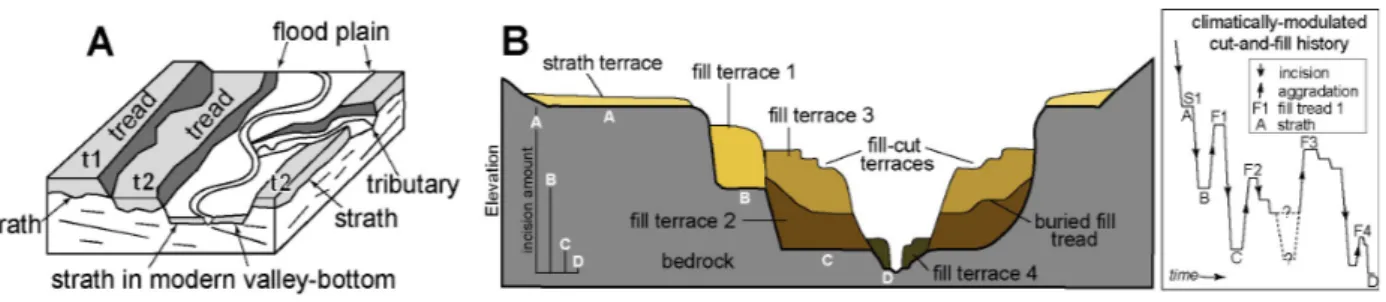
commonly used to measure the rate of vertical stream incision, typically interpreted as the rate of base level fall, inclusive of rock uplift and associated crustal deformation (Wegmann and Pazzaglia, 2009). Terrace deposits are unconsolidated allostratigraphic units with a basal unconformity called a ”strath”, typically cut across bedrock, and a constructional bench-like top called a ”tread” (see Fig. 1) The formation of the landform called ”strath terrace” (Bull, 1991) corresponds to a time of erosion and widening of the valley caused by the thin mobile alluvial cover of a bedrock channel (Pazzaglia and Brandon, 2001).
Figure 1: Cartoon and photographic relationships between terraces, terrace deposits and incisionaggradation history as used in this study, modified from Burbank and Anderson, 2001.
The formation of thick alluvial deposits called ”fill terraces” (Bull, 1991) corresponds to the time of valley aggradation when the channel is vertically raised above its strath. The passage from aggradation to downcutting, in response to a decrease in sediment supply and/or greater effective discharge (Schumm, 1969; Hancock and Anderson, 2002), leaves the aggradational surface abandoned as a terrace in the valley (Burbank and Anderson, 2001). The initial gradient of the strath is the gradient of the channel that cuts it, approximated in most cases by the modern channel gradient so long as the modern channel has a thin mobile alluvial bed in contact with the bedrock (Wegmann and Pazzaglia, 2009). Where a strath lies in the landscape, when it was carved, and when it was abandoned by incision are predominant considerations leading to a useful terrace genesis model, particularly one that is portable to tectonic problems. The longitudinal profile of correlated strath surfaces and the vertical separation between those surfaces and modern channel bedrock allows to constrain rates of tectonic deformation.
A river that is neither aggrading nor degrading can be considered to be in equilibrium (Bull, 1991). In such a river the formation of terraces is the geomorphic and sedimentologic expression of unsteady vertical channel incision (e.g. Schumm et al., 1987; Bridgland, 2000) that may occur over short-time scales in response to transient changes in sediment and water input to channels, or due to changes in base-level as an
rate of rock uplift with the built-in assumption that strath formation is a shorter-term transient phenomenon embedded in a long-term quasi-equilibrium channel profile (Mackin, 1948) more or less represented by the gradient of the modern river profile (Knox, 1975; Bull and Knuepfer, 1987; Merritts et al., 1994; Personius, 1995; Burbank et al., 1996; Lave and Avouac, 2000; Pazzaglia and Brandon, 2001; Wegmann and Pazzaglia, 2002). Finally, the use of fluvial terraces to constrain rock deformation is based on the premise that vertical channel incision is primarily a response to rock uplift, and that other contributions to downcutting, such as distal base-level fall and climatically modulated changes in watershed hydrology can be independently determined (e.g., Rockwell et al., 1984; Lav´e and Avouac, 2000). Within these settings, kinematic scenarios resulting in different uplift patterns at the surface should be distinguished using the geometry of fluvial terraces (Wilson et al., 2009). In order to use this terraces geometry and calculate tectonic rates, the formation age of the strath must be constrained.
Nevertheless, the absence of well-documented age for these surfaces is the most typical difficulty in extracting tectonic informations (Burbank and Anderson, 2001). Radiocarbon dating is used for the Holocene and Upper Pleistocene deposits, sampling where possible directly above the strath. As support to the difficulty in finding datable material, the creation of soil chronosequences, based on soil characters related to age and climate has been proved useful. Particularly for Holocene to uppermost Pleistocene soils (Eppes et al., 2008), this method serves as a descriptive methodology for correlating alluvial bodies and their topping soils, and for recognizing alluvial bodies on top of which soils develop.
Observations from tectonically active settings demonstrate that straths lie at variable distances above the modern valley bottom, but their ages tend to cluster around periods coincident with known climatic changes, leading geomorphologists to claim for climate change as the main driver of the periodic incision necessary for terrace genesis (Bull, 1991; Merritts et al., 1994; Meyer et al., 1995; Burbank et al., 1996; Pazzaglia et al., 1998; Lav and Avouac, 2001; Pazzaglia and Brandon, 2001).
In absence of numeric ages, particularly for deposits older than the radiocarbon method can detect, the best approximation for terrace strath age is the chronology of the marine oxygen isotope record as a long-term framework for identifying likely times of strath cutting and channel aggradation or incision (e.g. Bridgland and westaway, 2008).
In contrast to efforts aimed at directly measuring tectonic geomorphic processes, the interactions be-tween deformation and surface processes can also be studied theoretically. Complex models for landscape evolution in different tectonic environments have recently been formulated. In particular simple models (for
both detachment and transport-limited systems) predict power-law relations between channel gradient and drainage area in the form of equation (e.g. Whipple and Tucker, 1999; Willgoose et al., 1991).
Given the complexity of the Northern Apennines and the different scenarios proposed for the evolution of the mountain front, we choose to study this area using tectonic geomorphology.
1.2 Geological setting
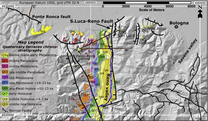
The Northern Apennines are a fold and thrust belt developed as the pro-wedge of the subducting Adria plate since the Oligocene. They are a known worldwide as an example of a retreating boundary (sensu Royden 1993), for their coeval character of compression at the front and extension at the hinterland (Elter et al., 1975). The main mountain front of the Northern Apennines is commonly interpreted as a continuous thrust structure (also known as Pede-Apenninic Thrust Front PTF, Boccaletti et al., 1985) that offsets Quaternary deposits and locally may be emergent (e.g. Boccaletti et al., 2004; Lavecchia et al., 2003; 2004; Picotti and Pazzaglia, 2008), as an out-of-sequence thrust rooted deep in the wedge. In contrast, the buried front of the Northern Apennines, i.e. the outermost thrust, is sometimes viewed as the true active front of the Northern Apennines (Scrocca, 2006), but this view cannot explain the rapid Quaternary growth of the main geomor-phic feature, i.e. the mountain front, since the thrust front creates almost no relief. Near Bologna, the PTF or its attendant splays do not appear to be emergent. Here the PTF is a deep, steep, blind structure asso-ciated with the frontal limb of an antiform that defines the mountain front (Picotti and Pazzaglia, 2008). Progressively deformed alluvial fan and river terrace growth strata (Picotti and Pazzaglia, 2008) clearly document this large-wavelength foreland-dipping flexure, in which however, small, but pervasive high-angle normal faults (Picotti et al., 2007) are embedded. However, locally west of Bologna, in the Emilia foothills and adjacent Po Plain, shallow splays of the PTF remain active in the Miocene - Pliocene thrust belt (e.g. Scrocca et al., 2007). The geometry of the Quaternary activity is complex. Since the middle Pleistocene, deformation appears to be concentrated in building the mountain front and defining the southern boundary of the Po basin (Picotti and Pazzaglia, 2008), however, geomorphic and stratigraphic features suggest as well shortening to the northwest, oblique to the pre-Quaternary direction (Gasperi et al., 1999; Picotti et al., 2007), having a clear topographic expression moving west of Bologna, where the shape of the mountain front is more irregular and affected by local dome and swell interference short- wavelength structures (see Fig. 2).
cinematic continuity of the deep thrust west of Bologna? In which term are the short-wavelength structures connected with the deep structure? How this tectonic data frame matches with the seismicity of the area? To answer these scientific problem, the Northern Apennines mountain front has been analyzed with in three different papers published or submitted to scientific reviews.
1.3 Aim and outline of the thesis
In order to respond to the previous questions, aim of this research is to use the tectonic geomorphology to analyze and quantify the active deformations of the Northern Apennines mountain front, in places where tectonic activity has been suggested (Bernini and Papani, 1987; Gasperi et al., 1999) but no quantitative reconstruction are available in literature. The resulting tectonic dataframe is to be integrated and validated by the comparison with subsurface, seismic, geomorphic and geodetic independent datasets. As already mentioned, three scientific papers form the core of this research.
In paper 1, Topographic expression of active faults in the foothills of the Northern Apennines, the imprint that active faults leave in the earth ˜Os surface is identified, using a combination of geomorphic and geologic metrics including triangular facets, the shape of mountain front, the drainage network, and incised river valleys with inset terraces. The goal is to provide a representative view of high angle, mostly normal faults in the foothills of the Northern Apennines in the lower Reno valley and east of Bologna, includ-ing documentation of their throw, strike lengths, and slip rates. These data are further explored to discuss the role of high angle faulting in shaping the Apennine landscape and the broader, formative underlying tectonic/geodynamic processes.
Paper 2, titled Thrust-fold growth history at the mountain front of the Northern Apennines from quantitative landscape analysis, focus on the analysis of fluvial channels, Quaternary deposits, and swath topographic profiles. Two areas of study are located ∼ 40 km and ∼ 80 km west of Bologna, respectively in the Castelvetro - Vignola foothills and the Ghiardo plateau near San Polo d’Enza (see Fig. 2 and 3 in Paper 2). In particular, at Castelvetro (Mo), two distinct anticlines show evidence of interaction of two deformation trends: the so-called Apenninic WNW and the anti-Apenninic NE, with a final dome-and-swell geometry. The Ghiardo plateau is an east-west-elongated hill that sits several kilometers north of the mountain front. This area attracted our interest because here the mountain front is defined by
to-Figure 2: The foothills of the Northern Apennines: the boxes represent the areas investigated in the three papers presented in this thesis.
pographically striking flatirons underlain by middle Pleistocene conglomerates, that led Bernini and Papani (1987) and Boccaletti et al. (2004) to argue for emergence of the PTF. The main goal is to extract the signal of channel response to active tectonics by stream channel steepness analysis and test the sensitivity of the method in an area of low-noise background of climate change and lithologic variation. The behavior of steepness index of river longitudinal profiles has been analyzed for channels that have comparable discharge in the reaches where they traverse across the culmination of the anticlines. Topographic swath profiles and the steepness index have been compared with field stratigraphic, structural mapping, aquifer geometry, and seismic reflection profiles relationships.
Paper 3, The active deep mountain front of the Northern Apennines: seismicity and geo-morphology, improves the previous study in the Castelvetro - Vignola foothills and in the Ghiardo Plateau, with the aim to quantify and determine the style of the deformation of the local short-wavelength anticlines. The two domal structures have been studied in detail, using Pleistocene river terraces as growth strata, and reflection seismic profiles. River incision and uplift rates for the Enza and Panaro valleys have been measures, as well as the tilting rate of the mountain front, using a terrace and alluvial fan stratigraphy that produced a unified inter-basin chronostratigraphy across the Northern Apennines (Eppes at al., 2008, Picotti and Pazzaglia 2008, Wegmann and Pazzaglia 2009, Wilson et al., 2009).
The connection of these surficial compressional structures with the deep structure building the mountain front have been investigated, and a simple trishear fault propagation folding model has been constrained with the geometry and uplift rates of the anticlines.
In conclusion, the activity and structural characteristics of the different wave-length structures have been compared, at regional scale, with moment tensors available for the seismicity with magnitude between Mw 4.1 to 5.4 for the last 30 years, the velocity field for Africa-Europe convergence reconstructed from GPS data (D’Agostino et al. 2008), the Late Pleistocene to Holocene Apenninic trend of river incision obtained from rates measured in the Enza and the Panaro valleys by this study, in the Reno valley by Picotti and Pazzaglia (2008), in the the Bidente valley by Wegmann and Pazzaglia (2009) and finally by Wilson et al., (2009) in the Stirone valley. On the basis of this comparison, a seismotectonic interpretation of the evolution of the mountain front has been proposed.
Author's personal copy
Topographic expression of active faults in the foothills of the Northern Apennines
Vincenzo Picottia, Alessio Ponzaa,⁎, Frank J. Pazzagliaba
Università di Bologna, Dipartimento di Scienze della Terra e Geologico Ambientali, Via Zamboni 67, 40127 Bologna, Italy bDepartment of Earth and Environmental Science, Lehigh University, 31 Williams, Bethlehem, PA 18015, USA
a b s t r a c t
a r t i c l e i n f o
Article history: Received 6 March 2008
Received in revised form 16 September 2008 Accepted 2 January 2009
Available online 19 January 2009 Keywords: Active faults Topography Surface processes Foothills Northern Apennines
Active faults that rupture the earth's surface leave an imprint on the topography that is recognized using a combination of geomorphic and geologic metrics including triangular facets, the shape of mountain fronts, the drainage network, and incised river valleys with inset terraces. We document the presence of a network of active, high-angle extensional faults, collectively embedded in the actively shortening mountain front of the Northern Apennines, that possess unique geomorphic expressions. We measure the strain rate for these structures andfind that they have a constant throw-to-length ratio. We demonstrate the necessary and sufficient conditions for triangular facet development in the footwalls of these faults and argue that rock-type exerts the strongest control. The slip rates of these faults range from 0.1 to 0.3 mm/yr, which is similar to the average rate of river incision and mountain front unroofing determined by corollary studies. The faults are a near-surface manifestation of deeper crustal processes that are actively uplifting rocks and growing topography at a rate commensurate with surface processes that are eroding the mountain front to base level. © 2009 Elsevier B.V. All rights reserved.
1. Introduction
Fault distribution may strongly influence landscape evolution in actively deforming areas and are of particular interest for seismic hazard assessment and especially when characterized by high slip rates (McCalpin and Nelson, 1996; Keller and Pinter, 1996). Along tectonically active mountain fronts, high angle normal faults are commonly easily recognized by their sharp relief caused by uplift of the footwall and enhanced subsidence of the hangingwall basin, causing development of exposed escarpments. In contrast, normal faults distal to the active mountain front may less distinct because of burial by sediments washed into the subsiding hangingwall basin, or concealment by surficial processes, such as large-scale mass move-ments in the footwall block. Nevertheless, high angle normal faults embedded in the hinterland of mountain ranges have clear geody-namic implications for the processes that uplift and deform rocks to make mountains despite their variable slip rates. How those faults interact with surface processes to make topography remains a topic of vigorous discussion (e.g.Roberts and Michetti, 2004).
In this paper, we investigate the foothills of the Northern Apennines, a mountain range characterized by rapid Pliocene and Pleistocene uplift and exhumation (Balestrieri et al., 2003; Bartolini, 2003). The Apennines mountain front and its adjoining foothills are riddled with geologic and geomorphic evidence of active tectonics such as growing folds and faults that collectively represent the near-surface structural response of ongoing Adria-Europe convergence
(Bertotti et al., 1997; Capozzi and Picotti, 2002; Simoni et al., 2003; Picotti and Pazzaglia, 2008). This mountain front is commonly described as an out-of sequence structure that is backstepping with respect to the tip of the northern Apennines deformed wedge, presently buried below the plain of the Po river (Fig. 1;Picotti and Pazzaglia, 2008, with references). The northeast verging accretion-ary wedge of the Northern Apennines is considered inactive because it is sealed by almost undeformed alluvial deposits of Middle Pleistocene to Holocene (seeFig. 1b). Locally, in the Emilia foothills and adjacent Po Plain, however, some thrusts appear reactivating the thrust belt in various ways (e.g. Scrocca et al., 2007), but with remarkable differences, such as a northwest vergence (Picotti et al., 2007). Furthermore, the mountain front of the Northern Apeninnes is thought to be the emergence of a thrust cutting through the Quaternary (e.g.Boccaletti et al., 2004). In a recent paper,Picotti and Pazzaglia (2008) documented that the structure, also known as Pede-Apenninic Thrust Front, does not exist as continuous feature in the upper crust, whereas the present-day compression is accounted by a steep blind ramp, located at around 15 to 18 km of depth. In this frame of ongoing subduction and active compression in the middle crust, the normal faults we intend to describe are active in the upper crust only (Fig. 1b) and have been related to two different processes (see Picotti and Pazzaglia, 2008). In the south, toward the water divide, the stretching, documented also by geodetic strain measure-ments (e.g. GPS data inSerpelloni et al., 2005), is thought to be associate to the retreat of the upper (Tyrrhenian) plate, a process prograding from the Tyrrhenian back-arc basin toward the northeast since the Pliocene time (Elter et al., 1975). To the north, at the foothills close to the mountain front, the normal faults appear associated to the growing ramp anticline as upper crustal expression
Tectonophysics 474 (2009) 285–294
⁎ Corresponding author. Tel.: +39 051 2094574; fax: +39 051 2094522. E-mail address:[email protected](A. Ponza).
0040-1951/$– see front matter © 2009 Elsevier B.V. All rights reserved. doi:10.1016/j.tecto.2009.01.009
Contents lists available atScienceDirect
Tectonophysics
Author's personal copy
of the middle crustal thrust. The association of normal faulting on the crest of the anticlines is common (e.g.Morley, 2007) and it is due to the inversion of the local stressfield in the outer arch of the fold. Our goal is to provide a representative view of high angle, mostly normal faults in the foothills of the Northern Apennines around Bologna including documentation of their throw, strike lengths, and slip rates. These data are further explored to discuss the role of high angle faulting in shaping the Apennine landscape and the broader, formative underlying tectonic/geodynamic processes.
The most important data applied for our analysis is a geologic map synthesized from our observations and key published maps and reports (seePicotti and Pazzaglia, 2008and reference therein), supplied with balanced cross sections, regional DEM-based topo-graphic and river course analyses, aerial photography and satellite imagery. Also, offsets of surface of sedimentary recent deposits such as alluvial terraces have been utilized in identifying recent faults. We present a dataset of faults, some of which already known in
literature, and discuss the data in terms of their structural development, their interaction with the other landscape-shaping processes such as rock-type resistance to erosion, and some of their implications for seismic hazards. Our data argue for the predomi-nance of high angle normal faults embedded in the carapace of an actively shortening mountain range. Furthermore, we find that footwall blocks tend to have higher rates of watershed-averaged cosmogenically-measured erosion (Cyr and Granger, 2008) than directly adjacent hangingwall blocks.
2. Data
2.1. The S. Luca–Reno fault
The surface trace of the S. Luca–Reno fault develops 7 km with north–south trend. It is a normal fault that dips to the west and defines the easternflank of the lower reach of the Reno River valley (Figs. 2
Fig. 1. a) Location of the studied area in the foothills of the Northern Apennines at the boundary between the extensional and the compressional realms. Note the track of the cross section PP′, and the location ofFig. 2(white box). b) Cross section across the front of the Northern Apennines, showing the structural style of the frontal accretion, already inactive. The red faults represent the active features, normal faults at the surface and compressional structures in the middle crust (modified afterPicotti and Pazzaglia, 2008). (For interpretation of the references to colour in thisfigure legend, the reader is referred to the web version of this article.)
Author's personal copy
and 3). The fault runs along the markedly linear easternflank of the Reno valley and is characterized by west-facing mountain-front facets, already reported byBoccaletti et al. (2004). Virtually all of the terraces of the river deposits are preserved on the west side of this part of the Reno valley with the Reno channel restricted to the east side of its markedly asymmetric valley. Evidence for west to east shifting of the mouth of the Reno during the Pleistocene is also mirrored by coarse fluvial deposits of Reno provenance interbedded with the littoral Sabbie di Imola toward the Lavino valley which is west of current river location. The S. Luca–Reno fault terminates in the north at the Bologna mountain front escarpment whereas its southern tip steps eastward and is developed as an ENE-striking fault (Fig. 3). The bedrock of the footwall consists of Lower Miocene limestones and marly limestones. At the mountain front, the youngest geological unit cut by this fault is the Middle Pleistocene Sabbie di Imola (about 700 kyr), as any offset of younger Pleistocene terraces or hillslope deposits is ambiguous. Offset of the Sabbie di Imola indicates ~ 150 m of throw (seeFig. 4a and b), for a mean slip rate of ~0.2 mm/yr (profile AA′ inFig. 4a). In the middle of the fault, the footwall lithology transitions to mudstones and scaly argillites and the throw increases to 230 m (Fig. 4b) with a slip rate of ~0.3 mm/yr (profile BB′ inFig. 4b). In spite of this major fault activity, the footwall does not show facets and its topographic crest is shifted to the east. The displacement–length ratio (Dmax/L) for this structure is around 0.03 and falls on the line defining normal faults proposed byKim and Sanderson (2005).
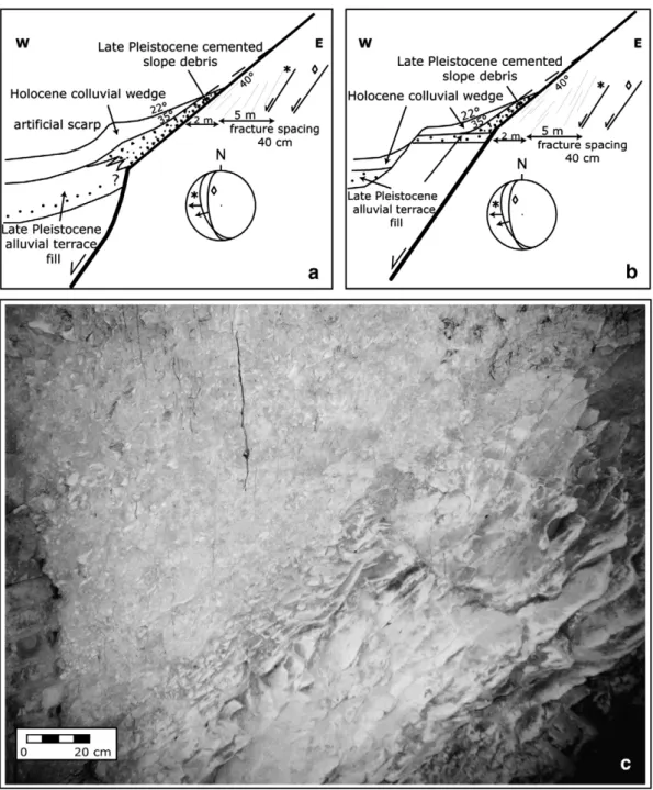
The triangular facets, generally considered valid indicators of mountain fronts bound by active faults, rarely represent the original, exhumed fault plane but rather its degradational scarp (e.g.Bull and Fadden, 1977). Thus, the facet slope reflects a balance between the rate of fault slip, soil development, and hillslope erosion (Menges, 1990). Rock resistance strongly controls the latter for faults, so that faceted surfaces are not preserved in exposure, where the footwall is dominated by mudstones and argillites, as in the southern reach of the S. Luca–Reno fault. In the northern reach of the fault, the calcareous nature of the bedrock allows development of triangular facets. Here a 15 m long tunnel (excavated during the WW II as
bomb shelter) offers a cross section through the footslope, with its surficial deposits and structural features for study (Fig. 5). The exposure is characterized by a colluvial ~ 1 m thick, consisting of bedrock clasts embeddedfloating in a brownish soil matrix. This colluvium unconformably overlies a wedge of slope debris, dipping 35° toward west, consisting of a stratified sedimentary breccia, mostly cemented and matrix supported, with local clast-supported layers (see picture inFig. 5). The breccia unconformably overlies a smooth surface of bedrock, dipping 40°, representing the buried triangular facet (see picture inFig. 5).
No absolute determination is available for the surficial units, but their texture, stratigraphy, and soil development of the colluviums is very similar to Holocene colluviums described for the Reno valley (Eppes et al., 2008), whereas the breccia is a late Pleistocene periglacial deposit.
Two possible alternatives are provided, both supported by available data (see Fig. 5). Fig. 5a illustrates both slope deposits covering the Qt5 alluvium ofPicotti and Pazzaglia (2008)that is well dated to the onset of deglaciation at around 19 ky.Fig. 5b shows the units burying the Qt4 alluvium that is believed to be ~35 ky old (Wegmann and Pazzaglia, in review). Both interpretations support a latest Pleistocene age for the slope breccia (19–11 ky) and a Holocene age for the colluvium (see Fig. 6 ofPicotti and Pazzaglia, 2008). Similar colluvial units commonly bury the treads of terraces Qt4, Qt5, and Qt6 in the Reno valley and these colluvial wedges have yielded primarily middle Holocene radiocarbon ages (Amorosi et al., 1996; Eppes et al., 2008).
The bedrock exposures for thefirst 2 m down-tunnel show a tight (around 10 cm) spacing of anastomising fractures that dip 45–50° to the west, whereas the next 5 m show a frequency decrease (about 40 cm of spacing) of similarly dipping fractures. These fractures do not show evidence of slip, disappear toward the interior of the tunnel, and clearly control the dip of the external slope and are believed to belong to the damage zone (sensuChester and Logan, 1986; Billi et al., 2003; Kim et al., 2004) associated with the master fault. This must have been located a few meters to the west of the slope and now mostly eroded.
Fig. 2. The foothills of the Northern Apennines around Bologna and the faults described in this paper. The normal faults are represented with barbs on the downthrown limb. The dots represent the location of historical events (last 700 years) after the Italian catalog CPTI (fromhttp://emidius.mi.ingv.it/DOM/).
287 V. Picotti et al. / Tectonophysics 474 (2009) 285–294
Author's personal copy
Two additional fault planes (Fig. 5), showing millimetric normal movement with top to the west parallel to the master fault, are exposed several meters further into the tunnel interior.
2.2. The Riolo Terme fault
The Riolo Terme fault strikes WNW and its surface trace can be followed for approximately 12 km. Its terminations are poorly defined due to small displacement and lack of stratigraphic correlation points, because it affects homogeneous bedrock. Furthermore, the fault cuts across Pliocene and Pleistocene mudstones (Argille Azzurre Fm), which makes it difficult to identify its exact location, except where distinct biozones are recognized and correlated in the hangingwall and footwall (Fig. 6). We studied this fault through two profiles across the interfluves where biostratigraphic data are available from two
unpublished thesis works (Viaggi, 1991; Sami, 1992, Fig. 6). The profiles show a general dip to the northeast, with a decrease of the dip from south to north. The southwest dipping normal fault creates an asymmetric hogback with steeper southern slopes. Given this lithology and the present-day climatic conditions, the gradient of the southern slopes are determined by weathering, whereas the northern slopes are soil-mantled and transport-limited. As an example of the role of rock resistance in weathering-limited southern slopes, the highest hill visible in the profiles of Fig. 6 consists of bedded gypsum of Messinian age, particularly resistant also because of the effective infiltration associated to karst evolution.
The Riolo Terme fault in the Santerno–Senio interfluves (Fig. 6b, profile C–C′) displaces the Upper Pliocene sequence of the Argille Azzurre by about 260 m, whereas another smaller normal fault about 2 km to the north is associated with around 100 m of
Fig. 3. DEM map of the lower intramontane reach of the Reno valley, showing the position of the active faults and the Pleistocene to Holocene continental deposits (modified afterPicotti and Pazzaglia 2008). AA′ and BB′ are the traces of cross sections in this figure, EE′ is the trace of the seismic profile shown inFig. 6.
Fig. 4. Cross sections across the S. Luca–Reno fault. In a), note the stratigraphic separation of the Middle Pleistocene Sabbie Gialle. In b), the vertical throw is measured using the separation of the Messinian evaporites.
Author's personal copy
stratigraphic normal throw. Some 9 km to the east toward the Lamone valley, the Riolo Terme fault shows ~ 250 m of total separation, while cutting the Lower Pleistocene Argille Azzurre. This area (Fig. 6c, profile D–D′) displays a third fault situated to the south of the Riolo Terme fault. This latter is a south-dipping normal fault cutting through the Messinian succession. This fault disrupts the continuity of the gypsum hogback, offsetting the northern structural slope with some 100 m, which corresponds to the height of the present-day topographic escarpment.
The slip rate of the main Riolo Terme fault is 0.35 mm/yr, if we infer the onset of slip to be Middle Pleistocene, as is the case for the S. Luca– Reno fault, for example. A lower estimate of ~ 0.18 mm/yr is calculated if the onset of faulting is Lower Pleistocene rather than Middle Pleistocene. The Dmax/L of the Riolo fault is ~0.02–0.03 if we consider the other smaller faults as linked to the same fault system. This value
falls below the normal fault line ofKim and Sanderson (2005). Either this fault has abnormally small amounts of slip for its length or we are underestimating the slip due to lack of definitive offset stratigraphic horizons.
The Riolo Terme fault effectively intercepts the subsurfacefluid circulation and allows natural seepage of both formation and meteoric waters. These seeps have been used since the Middle Age for their positive effects on health and/or as a source of salt (seeFig. 6c). Similarly, there is a source of sulfur-rich water located at the most depressed point where the fault intercepts the topography, i.e. the Senio valley bottom. The formation waters, supplied by deeper Tertiary reservoirs, on the contrary, form seeps at several points along the fault, seemingly independently of the topography. The positions of these seeps suggest that the fault zone, here cutting across mudstones, acts an effective conduit to deep aquifers.
Fig. 5. A section across a triangular facet. a) and b) show two possible interpretations of the geological situation observed in the tunnel entering the base of slope of the facet. Two meso-scale faults are projected in the stereonet. Interpretation a) is that of a blind fault, where the deformation of the latest Pleistocene and Holocene is accommodated by folding of the surface units. Interpretation b) suggests that the fault cuts almost to the surface and a configuration of the alluvial terraces different than that of interpretation a). c) displays the bedrock contact of the bedded slope debris. Note the smooth surface and the tight spacing of the fracturing in the bedrock.
289 V. Picotti et al. / Tectonophysics 474 (2009) 285–294
Author's personal copy
2.3. The Ponte Ronca fault
The surface trace of the Ponte Ronca fault strikes WNW and is detectable for a distance of approximately 4 km along the mountain front. This feature has been recently identified in a high resolution high-angle reflection seismic profile, acquired during the NSF project RETREAT (REtreating TRench, Extension, and Accretion Tectonics) (see Picotti and Pazzaglia, 2008). This southwest dipping fault has a measured maximum throw of 120 m (Fig. 7; applying for a Dmax/L of 0.03) and offsets middle Pleistocene to Holocene deposits. In the seismic line, it is seen that the hangingwall of the Ponte Ronca fault is subsequently cut by several other minor faults (Fig. 7). The reflectors corresponding to the interval from the Sabbie di Imola to recent colluvium, display growth configuration in the hangingwall of the Ponte Ronca fault. Still, its middle Pleistocene activity cannot be determined, due to the absence of the Synthem Emiliano Inferiore (deposited between 600 and 400 ky,Fig. 7) that pinches out a few hundreds of meters to the north of the fault. The calculated mean long-term slip rate is ~ 0.13 mm/yr, with a possible increase in the slip rate during latest Pleistocene to Holocene, depending on the precise age of the undated surficial colluviums.
2.4. The Scascoli fault
The Scascoli fault (Bertotti et al., 1997) is the southernmost and the longest of the studied faults of the foothills of the Northern Apennines
(Figs. 2 and 7). It has recently been crossed by the High Velocity Railway tunnel that allows for a detailed investigation of its configuration and to determine its offset that locally reaches more than 1000 m (seeFigs. 2 and 8). The total fault system length is around 32 km, beginning on the west side of the Reno Valley, where it cuts the middle Pleistocene alluvial terrace Qt1 (~600 ka) (Picotti and Pazzaglia, 2008). It can be followed to the east towards the Santerno valley, traversing the Setta, Savena, Zena, Idice and Sillaro valleys with a clear topographic expression (seeFig. 2).
The Scascoli fault has Dmax/L ratio of 0.031, a value similar to the other faults, suggesting self-similarity of the deformation matrix in the northern Apennine foothills. Given a similar Dmax/L ratio, the larger displacement and length of the Scascoli fault can be interpreted to have either a rapid slip rate (~ 1.4 mm/yr) on a young fault initiated in the middle Pleistocene, or a slower slip rate, similar to other foothills normal faults, on a much older fault system of late Pliocene– early Pleistocene age. The slow slip is our preferred interpretation, owing that the growth rate of each fault is strongly controlled by the rheology of the upper crust. Moreover, a late Pliocene age of the Scascoli fault is in agreement with the onset of exhumation of this side of the Northern Apennines (Zattin et al., 2002) and the observation that, south of the water divide, the onset of the normal faults are late Pliocene–earliest Pleistocene, as documented by the clastic infill of the Mugello graben (seeFig. 2,Benvenuti, 1997).
The High Velocity Railway tunnel unexpectedly broke through the fault plane during construction and immediately experienced a seepage
Fig. 6. The Riolo Terme fault and two cross sections showing the structures and the stratigraphic separations, documented through biostratigraphic data. Note the presence of secondary faults and of an active subsurface water circulation, effectively interrupted by the faults. The Riolo Terme fault drains essentially meteoric waters, whereas connate waters are seeping along the secondary fault.
Author's personal copy
of oil and gas. Diffuse seepage of condensate was described first by Bertotti et al. (1997) along this fault, documenting its effective capability of this fault to tap deep hydrocarbon reservoirs, likely located in the Tertiary flysch below alloctonous less permeable units, as documented some tens of km to the west byCapozzi and Picotti (2002). 2.5. A general picture of the active faults around Bologna
The four active faults of the Bologna area described above are representative members of a much larger system of high angle normal
faults of the foothills of the Northern Apennines (Fig. 2). Most of these faults do not offset Pleistocene deposits, so their strike lengths and cumulative throw are poorly known (as an example, seeCapozzi and Picotti, 2006). Cumulatively, these faults represent a component of penetrative brittle shear accompanied by modest amounts of crustal stretching. One example is provided by the four active N-striking faults that traverse the lower reach of the Reno Valley (see Figs. 2 and 7 ofPicotti and Pazzaglia, 2008). The cumulative displacement rate of these structures is ~ 0.77 mm/yr. Assuming a mean fault dip of 60°, the total horizontal stretching rate is 0.25 mm/yr, for a total net extension of 200 m since the Middle Pleistocene. The origin of this extension is partitioned among hangingwall ramp folding atop a deep buried thrust (Picotti and Pazzaglia, 2008), prevalent at the mountain front (Ponte Ronca fault), and retreating of the upper plate, i.e. the well documented extension of the Apennine crest (Scascoli fault), a process started earlier and acting at rates of several mm/yr of total stretching according to geodetic GPS measurements (Serpelloni et al., 2005, see alsoPicotti and Pazzaglia, 2008, for further discussion). 3. Discussion
3.1. Topographic expression of active faults (Local tectonic uplift vs local erosion
Exhumation of the Northern Apennines started at around 3 Ma and has proceeded at an average rate of about 0.7 mm/yr based largely on an apatitefission track (AFT) data base (Zattin et al., 2002; Balestrieri et al., 2003). This exhumation temporally overlaps with the widely accepted notion that surface uplift and relief in the Apennines was greatly enhanced since the Middle Pleistocene (Bartolini, 2003). Data from disparate erosion rate studies either corroborate the AFT results, such as reconstructed sediment volumes (Bartolini, 2003), or suggest slightly lower rates of ~ 0.2–0.4 mm/yr for methods that integrate across Holocene time scales, such as measuring river suspended sediments (Simoni et al., 2003) or from basin-wide cosmogenic nuclides inventories of sand bedload in river channels (Cyr and Granger, 2008). It is interesting to note that the highest rates of erosion reported in theCyr and Granger (2008) study come from watersheds we report to be in the uplifted footwall of active normal faults.Cyr and Granger (2008)did not consider active normal faults in
Fig. 8. A cross section through the Scascoli fault along a new tunnel of the railway (a) and minor extensional features at the Scascoli gorge (b and c), describing the deformational style of the Miocene epi-Ligurian rocks in between the two main faults.
Fig. 7. A seismic profile across the Ponte Ronca fault and associated features (modified afterPicotti and Pazzaglia, 2008). SeeFig. 2for location.
291 V. Picotti et al. / Tectonophysics 474 (2009) 285–294
Author's personal copy
their sampling strategy so it remains a testable hypothesis to determine if the range of cosmogenically-measured erosion rates reflects uncertainties with the data, natural variations due to transients in the rate of landscape change, or a strong base level fall forcing because of the active normal faults. It is in this context of large scale uplift of the Apennines and its balance with erosional processes that the active normal faults imprint a unique signature upon the landscape.
A general observation is that there is little net subsidence of the hangingwall blocks. Also there is a non-uniform topographic expression of uplifted footwall blocks, especially where the footwall is underlain by rock type less resistant to erosion. Exceptions to this are faults affecting resistant rock types, such as limestone or the gypsum evaporites, with the latter allowing for fast karst development, therefore lowering the capability of hillslope erosion. We found triangular facets developed in limestone only, whereas fault scarps in mudstone are consequently characterized by badlands (calanchi) enhanced presumably because of continuous local base-level lowering at the footwall block escarpment. The general message, therefore, is that active faults, such as those found in the foothills of the Northern Apennines, are not uniformly obvious from a simple geomorphic analysis.
The key topographic fingerprints of the Apennine high angle normal faults include offset of late Pleistocene and Holocene terraces, facets in resistant rocks, and depressionsfilled with colluvium. The fault indicators, which provide best results even in the absence of visible traces, are the perturbations of the drainages, such as documented for the drainage density (Simoni et al., 2003). The faults in the study case interact with the catchments in several ways. The N–S faults, like the S. Luca–Reno fault, are associated with tilt of the hangingwall so that it tends to deflect the Reno channel, shifting it eastward against the footwall scarp. A similar tilt has also been described for the Lamone catchment, located some 30 km to the southeast of the S. Luca–Reno fault bySimoni et al. (2003). It appears as a widespread feature in the valley reaches developed along the N-oriented faults.
In contrast, south-dipping normal faults, such as the Riolo Terme fault, tend to uplift a footwall block as seen in the lower reach of the Senio river course. The long-term result is the progressive defection of the river along the damage zone, until the capture executed by the adjacent trunk channel (the Sintria River). The footwall block bears the record of the progressive abandoning of valley reaches, leaving prominent wind gaps (seeFig. 9). In particular, considering net uplift
Fig. 9. The interaction offluvial erosion and footwall uplift for the Riolo Terme fault. Prominent wind gaps are visible on the interfluve, documenting the abandonment of the previous valleys (t1 and t2 wind gaps are discussed in the text).
Author's personal copy
of the footwall and using the calculated slip rate in estimation of this uplift, it is possible to calibrate the timing of valley abandonment and the formation of the two wind gaps at 145 m (t1) and 85 m (t2) above the present Senio river. Given a constant slip rate of 0.35 mm/ yr, ages of the wind gaps are ~ 400 ky for t1 and ~ 240 ky for t2. These values may be younger if it is considered the river incision into the hangingwall. Regional considerations (seePicotti and Pazzaglia, 2008; Cyr and Granger, 2008) suggest a local incision rate of about 0.2 mm/ yr. Therefore, a possible corrected age for the Senio wind gaps is ~260 and ~150 ky, respectively.
For north-dipping faults, such as the Scascoli fault, there is a long slip history that brought about the juxtaposition of different rock types along strike. This led to the development of different landscape features along the fault. The most striking feature is the western defection of the Setta river and its final capture into the Reno valley. This latter is also deflected to the west when approaching the footwall uplift of the Scascoli fault (seeFig. 2), that shows pronounced obsequent tributaries due to northward tilting. The Setta river is deflected along the fault plane, possibly following the damage zone and because the hangingwall rocks are more resistant. Given the vicinity of the Setta and the Savena valleys at the capture elbow it is likely that the Setta was discharging into the Savena prior to the capture, which probably occurred early during the Pleistocene.
A classic problem in the active fault studies is the localization of slip at surface in the cases of absent seismogenic rupture (De Martini et al., 2003). Frequently, the slip is claimed along the faceted spur at the slope deposit–bedrock interface, (e.g. the Magnola fault in the central Apennines,Palumbo et al., 2004; the Avion fault in central Greece, Ganas et al., 2005, see also Roberts and Michetti, 2004). In other cases, such as the northern Apennines at Colfiorito (September, 1997 earthquake) however, geologic and geodetic studies document that the surface deformation associated to the coseismic slip occurred several km within the hangingwall (Basili et al., 1998; De Martini et al., 2003). Similarly, observations of the Gubbio normal fault revealed pronounced faceting of the spurs cut by the main fault, but virtually no evidence of activity at the bedrock–surface deposit interface (Pucci et al., 2003). These studies suggest that many of the so-called reactivation belts at the bedrock– slope deposit interface are likely erosional and the result of mass-wastage processes, therefore masking the real surface deformation associated to tectonic movements.
In the case of the S. Luca–Reno fault, there is no evidence of slip between the surficial units and the bedrock. This fact could be interpreted in two ways: the fault is no longer active, or the fault is active and the slip is not localized at the bedrock–slope deposit interface. Taking as working hypothesis the mean constant slip rate of 0.2 mm/yr, the Holocene offset should be in the order of 2 m. We have not been able to document such throw, but, in our preferred interpretation of the footslope deposits and the distribution of the alluvial units (Figs. 4a and 3), a blind fault is likely present (Fig. 5a), and the Holocene accumulated slip may be accounted for by folding of the hangingwall over a buried fault tip of unknown depth (Fig. 5a). In this interpretation, the triangular facets are mostly an erosional feature, where the footwall escarpment is high, steep, and swept clear of footslope sediments by the location of the Reno trunk channel.
3.2. Seismotectonic bearing of the studied faults
There are published contrasting views on the seismogenic nature of the high angle normal faults at the entire Bologna mountain front in general (Pondrelli et al., 2006). The recently published seismotectonic map of the Region (Boccaletti et al., 2004) represents a comprehen-sive synthesis. Unfortunately, however, the location of historical and instrumental events is too inaccurate to allow for a certain correlation
between seismological events and the (assumed) active faults. In any event, some historical events with equivalent moment magnitudes of 5 to 5.5 (report of the last 850 years) are located to zones at or close to the S. Luca–Reno fault, as well as the Ponte Ronca and the Scascoli faults, (seeFig. 2). The expected surface rupture for similar events is zero or negligible and might be utilized to confirm our interpretation that most of recent deformation is not expressed at surface. These faults are capable of generating earthquakes every ~ 1000 years (Wells and Coppersmith, 1994; Keller and Pinter, 1996). This recurrence time is in agreement with the events recorded by the seismotectonic map ofBoccaletti et al. (2004), where the time window of the list is almost sufficient to record seismic activity.
A different case is presented by the Riolo Terme fault that is associated to a larger and more precisely located event (1781 A.D. MN5.5). In the cited map ofBoccaletti et al. (2004), the authors provided a reconstruction of the geometry of the inferred seismo-genic source, in agreement with the orientation of the fault investigated here. The literature, however, do not report any surface rupture, that should be expected with events of such magnitudes. We can therefore only infer that the coseismic movement of the Riolo Terme fault likely did not affect the fault along its entire length, but rather in a segment located near its eastern tip in the Lamone valley, where the epicenter is also located. In case of surface rupture of the entire fault of 12 km, in fact, the equivalent magnitude, according to the available literature data (e.g.Pavlides and Caputo, 2004) would have been M 6.5, a highly destructive event for the Italian standard. No such event has been recorded.Boccaletti et al. (2004)document for magnitudes M 5.5 to M 6 the rupture of a 3 to 4 km segment of the fault, which maybe in accordance with the present observation. In conclusion, new paleoseismic data would be necessary to better assess the seismic hazard of the study area, which is densely populated. The preliminary consideration is that the seismic risk would be high, even taking into account the low seismogenic depth of the described normal faults.
4. Conclusions
The normal faults in the foothills of the Northern Apennines documented in this paper, partially known in literature (Bertotti et al., 1997), are described in their geometry, length and displacement, and slip rate. The latter is averaged for the last 700–800 ky for most faults, whereas locally the slip rate history is reconstructed through the stratigraphic separation of dated late Pleistocene to Holocene units. The results consistently indicate that the faults have a moderate activity with slip rates ranging 0.1 to 0.3 mm/yr.
The geodynamic scenario of the Northern Apennines allows interpreting the origin of the observed faults as twofold: related to the retreat of the upper plate, at least the faults closer to the watershed, such as the Scascoli fault, characterized by kilometric throw and a likely pre-Quaternary onset of its activity. The faults located closer to the foothills represent stretching of the carapace that is folding at the mountain front, due to a deep blind reverse structure (Picotti and Pazzaglia, 2008). The topographic signature of these faults is very scarce, owing the average erosion rates are systematically higher than the slip rates. The classical indicators (such as the faceted spurs) are preserved only for the resistant lithologies, not common in this part of the Apenninic belt. This fact makes it difficult to recognize active faulting in this sector, when compared with the abundant data for the carbonate-rich central Apennines. Anyway, the deformation of the drainage, such as density variations or river piracy, can reveal the long-term record of slip along the fault. This survey of the normal fault active close to a major urban area (i.e. Bologna and surroundings) can help in assessing the seismic hazard of the area. For a better knowledge, however, a paleoseismological analysis is needed, together with some micro-seismic experiments along the faults.
293 V. Picotti et al. / Tectonophysics 474 (2009) 285–294
Author's personal copy
Acknowledgments
The authors are grateful to F. Roure and anonymous, whose thoughtful revisions greatly improved the manuscript. Grants R.F.O. (University of Bologna) are acknowledged. This work has been partly funded by GEO-EAR-0207980 (Project RETREAT) to support the collaboration between Pazzaglia and Picotti.
References
Amorosi, A., Farina, M., Severi, P., Preti, D., Caporale, L., Dio, G.D., 1996. Genetically related alluvial deposits across active fault zones: an example of alluvial fan-terrace correlation from the upper Quaternary of the southern Po Basin, Italy. Sedimentary Geology 102, 275–295.
Balestrieri, M.L., Bernet, M., Brandon, M.T., Picotti, V., Reiners, P., Zattin, M., 2003. Pliocene and Pleistocene exhumation and uplift of two key areas of the northern Apennines. In: Bartolini, C., Piccini, L., Catto, N.R. (Eds.), Uplift and Erosion; Driving Processes and Resulting Landforms; Dynamic Relations Between Crustal and Surficial Processes. Quaternary International, 101–102, 67–73.
Bartolini, C., 2003. When did the Northern Apennine become a mountain chain? In: Bartolini, C., Piccini, L., Catto, N.R. (Eds.), Uplift and Erosion; Driving Processes and Resulting Landforms; Dynamic Relations Between Crustal and Surficial Processes. Quaternary International, 101–102, 75–80.
Basili, R., Bosi, V., Galadini, F., Galli, P., Meghraoui, M., Messina, P., Moro, M., Sposato, A., 1998. The Colfiorito Earthquake sequence of September October 1997: surface breaks and seismotectonic implications for the Central Apennines (Italy). Journal of Earthquake Engineering 2 (2), 291–302.
Benvenuti, M., 1997. Physical stratigraphy of thefluvio-lacustrine Mugello Basin (Plio-Pleistocene, Northern Apennines, Italy. Giornale di Geologia 59, 91–111. Bertotti, G., Capozzi, R., Picotti, V., 1997. Extension controls Quaternary tectonics,
geomorphology, and sedimentation of the N-Apennines foothills and adjacent Po plain (Italy). Tectonophysics 282, 291–301.
Billi, A., Salvini, F., Storti, F., 2003. The damage zone-fault core transition in carbonate rocks: implication for fault growth structure and permeability. Journal of Structural Geology 25, 1777–1794.
Boccaletti, M., Bonini, M., Corti, G., Gasperini, P., Martelli, L., Piccardi, L., Tanini, C., Vannucci, G., 2004. Seismotectonic Map of the Emilia-Romagna Region, 1:250000. Regione Emilia-Romagna CNR. SELCA, Firenze.
Bull, W.B., Fadden, L.M., 1977. Tectonic geomorphology north and south of the Garlock Fault, California. In: Doehring, D.O. (Ed.), Geomorphology in Arid Regions: Binghamton, N.Y. State University of New York, Binghamton, pp. 115–138. Capozzi, R., Picotti, V., 2002. Fluid migration and origin of a mud volcano in the
Northern Apennines (Italy); the role of deeply rooted normal faults. Terra Nova 14, 363–370.
Capozzi, R., Picotti, V., 2006. Genesis of cold seeps and mud volcanoes in the Northern Apennines foothills. CIESM Workshop Monograph, Int. Comm. Sci. 25 Explor. Mediterranean Sea, Monaco, 26–29, 59–64.
Chester, F.M., Logan, J.M., 1986. Composite planar fabric of gouge from the Punchbowl Fault, California. Journal of Structural Geology 9, 621–634.
Cyr, A.J., Granger, D.G., 2008. Dynamic equilibrium among erosion, river incision, and coastal uplift in the northern Apennines, Italy. Geology 36, 2, 103–106. De Martini, P.M., Pino, N.A., Valensise, G., Mazza, S., 2003. Geodetic and seismologic
evidence for slip variability along a blind normal fault in the Umbria-Marche 1997– 1998 earthquakes (central Italy). Geophysical Journal International 155, 819–829. Elter, P., Giglia, G., Tongiorgi, M., Trevisan, L., 1975. Tensional and compressional areas in the recent (Tortonian to present) evolution of the Northern Apennines. Bollettino di Geofisica Teorica ed Applicata 17, 3–18.
Eppes, M.C., Bierma, R., Vinson, D., Pazzaglia, F.J., 2008. A soil chronosequence study of the Reno valley, Italy. Geoderma 147 (3–4), 97–104.
Ganas, A., Pavlides, S., Karastathis, V., 2005. DEM-based morphometry of range-front escarpments in Attica, central Greece, and its relation to fault slip rates. Geomorphology 65, 301–319.
Keller, E.A., Pinter, N., 1996. Active tectonics. Earthquakes, Uplift and Landscape. Prentice Hall, pp. 1–338.
Kim, Y.S., Sanderson, D.J., 2005. The relationships between displacement and length of faults: a review. Earth-Science Reviews 68, 317–334.
Kim, Y.S., Peacock, D.C.P., Sanderson, D.J., 2004. Fault damage zones. Journal of Structural Geology 26, 503–517.
McCalpin, J., Nelson, A., 1996. Introduction to paleoseismology. In: McCalpin, J.P. (Ed.), Paleoseismology. Academic Press, San Diego, California. 131pp.
Menges, C.M., 1990. Soil and geomorphic evolution of bedrock facets on a tectonically active mountain front, western Sangre de Cristo Mountains, New Mexico. Geomorphology 3, 301–332.
Morley, C.K., 2007. Development of crustal normal faults associated with deepwater fold growth. Journal of Structural Geology 29, 1148–1163.
Palumbo, L., Benedetti, L., Bourles, D., Cinque, A., Finkel, R., 2004. Slip history of the Magnola fault (Apennines, Central Italy) from 36Cl surface exposure dating: evidence for strong earthquakes over the Holocene. Earth and Planetary Science Letters 225, 163–176.
Pavlides, S., Caputo, R., 2004. Magnitude versus faults surface parameters: quantitative relationships from the Aegean Region. Tectonophysics 380, 159–188.
Picotti, V., Pazzaglia, F.J., 2008. A new active tectonic model for the construction of the Northern Apennines mountain front near Bologna (Italy). Journal of Geophysical Research 113, B08412.doi:10.1029/2007JB005307.
Picotti, V., Capozzi, R., Bertozzi, G., Mosca, F., Sitta, A., Tornaghi, M., 2007. The Miocene petroleum system of the Northern Apennines in the central Po Plain (Italy). In: Lacombe, O., Lavé, J., Roure, F., Vergés, J. (Eds.), Thrust Belts and Foreland Basins, from Fold Kinematics to Hydrocarbon System. Springer Verlag, pp. 117–131. Pondrelli, S., Salimbeni, S., Ekstrom, G., Morelli, A., Gasperini, P., Vannucci, G., 2006. The
Italian CMT dataset from 1977 to present. Physics of the Earth and Planetary Interiors 159, 286–303.
Pucci, S., Martini, P.M.D., Pantosti, D., Valensise, G., 2003. Geomorphology of the Gubbio Basin (Central Italy): understanding the active tectonics and earthquake potential. Annals of Geophysics 46 (5), 837–864.
Roberts, G.P., Michetti, A.M., 2004. Spatial and temporal variations in growth rates along active normal fault systems: an example from the Lazio-Abruzzo Apennines, central Italy. Journal of Structural Geology 26, 339–376.
Sami, M., 1992. Rilevamento geologico e biostratigrafico nella bassa valle del Lamone: dalla Fm. a Colombacci ai depositi terrazzati. Implicazioni cronologiche e paleoecologiche. Unpublished graduate thesis work, University of Bologna. Scrocca, D., Carminati, E., Doglioni, C., Marcantoni, D., 2007. Slab retreat and active
shortening along the Central-Northern Apennines. In: Lacombe, O., Roure, F., Verges, J. (Eds.), Thrust Belts and Foreland Basins, from Fold Kinematics to Hydrocarbon System. Springer Verlag, pp. 471–487.
Serpelloni, E., Anzidei, M., Baldi, P., Casula, G., Galvini, A., 2005. Crustal velocity and strain-ratefields in Italy and surrounding regions: new results from the analysis of 22 permanent and non-permanent GPS networks. Geophysical Journal International 161, 861–880.
Simoni, A., Elmi, C., Picotti, V., 2003. Late Quaternary uplift and valley evolution in the Northern Apennines; Lamone catchment. In: Bartolini, C., Piccini, L., Catto, N.R. (Eds.), Uplift and Erosion; Driving Processes and Resulting Landforms; Dynamic Relations Between Crustal and Surficial Processes. Quaternary International, 101–102, 253–267.
Viaggi, P., 1991. Biostratigrafia e Paleoclimatologia del Pliocene della sezione del Santerno. Unpublished graduate thesis work, University of Bologna, 158 pp. Wegmann, K.W. and Pazzaglia, F.J., in review, Fluvial terrace straths as growth strata
markers of late Quaternary tectonic deformation in the Emilia-Romagna and Marche Apennines, Basin Research, submitted.
Wells, D., Coppersmith, K., 1994. New empirical relationships among magnitude, rupture length, rupture width, rupture area, and surface displacement. Bulletin of the Seismological Society of America 84, 974–1002.
Zattin, M., Picotti, V., Zuffa, G., 2002. Fission-track reconstruction of the front of the northern Apennine thrust wedge and overlying Ligurian unit. American Journal of Sciences 302, 346–379.
Thrust-fold growth history at the mountain front of the Northern Apennines (Italy) from
1
quantitative landscape analysis
2
3
Alessio Ponza ([email protected]) a,*
4
Frank J. Pazzaglia ([email protected]) b
5
Vincenzo Picotti ([email protected]) a
6
7
a Università di Bologna, Dipartimento di Scienze del la Terra e Geologico Ambientali, Via
8
Zamboni 67, 40126 Bologna, Italy
9
b Department of Earth and Environmental Science, Lehigh University, 31 Williams, Bethlehem, PA
10
18015, USA
11
* Corresponding author
12
Dr. Alessio Ponza
13
Dipartimento di Scienze della Terra e Geologico-Ambientali
14
University of Bologna
15
Via Zamboni, 67
16
40126 Bologna - Italy
17
Tel. +39 051 2094546; Fax +39 051 2094522
18
Email: [email protected]
19
20
21
Abstract
22
We document the active tectonics of growing anticlines embedded in the Northern Apennine
23
Mountain front using a quantitative analysis of the topography. We infer rates of rock uplift for
24
these structures using stream channel steepness and incision. Individual structures appear to be
25
Manuscript