XXVII CICLO
TITOLO TESI
LANDSCAPE CHANGE AND FOREST DYNAMICS:
MULTI-SCALE PATTERN ANALYSIS AND BIODIVERSITY ISSUES
SSD BIO07/AGR05
TUTOR: COORDINATORE:
Prof. M.L. Carranza Prof. M. Marchetti
CANDIDATO:
Ludovico Frate
CORSO DI DOTTORATO IN “SCIENZE AGRO-FORESTALI, DELLE
TECNOLOGIE AGRO-INDUSTRIALI E DEL TERRITORIO RURALE. I
iii
ABSTRACT
The first section of the thesis focuses on the development of new methods in order to (i) provide the statistical significance of the observed differences when comparing different landscapes or their changes over time and (ii) analyze the scale dependence of the spatial pattern change. To properly handle the first issue, a new method to test the statistical significance of pattern metric values between two maps was proposed. In particular, the method was based on the use of Neutral Landscape Models (NLMs) able to reproduce a set of real-like (in terms of composition and configuration) simulated landscapes. For each simulated landscape, pattern metrics can be computed and can used to produce null empirical distributions for each metric. These empirical distributions can be used to determine if, the observed differences in terms of pattern metrics are significant for a given confidence interval. The second goal was achieved by extending the NLMs approach into the spatial domain to analyze the scale-dependence of landscape changes. Both methods were demonstrated in temperate forest landscapes.
The second section deals with the analysis of forest fragmentation in subtropical ecosystems. Also in this case new methods to quantify the spatial pattern of forests over time were proposed. First, the analysis of the spatial pattern change by means of sample-based techniques. By randomly sampling forest cover multi-temporal maps it was possible to statistically quantify and distinguish changes in forest cover from changes in the spatial pattern of forest. Second, the process of forest fragmentation was studied according to the “landscape context analysis” that is, each forest location was described by its context, using indices derived from the landscape that surrounds it, across a range of scales (from local to regional).
These methods each have their own set of advantages and limitations, and yet may work in a complementary manner. Moreover, in this work the usefulness of the proposed techniques was demonstrated in different environments such as temperate and subtropical forests. However, they can be easily extended to other landscapes such as urban landscapes and, in this respect, they could be an interesting field of further researches.
This thesis was conceived as a contribution to the increasingly urgent need to have sound scientific basis and effective tools to understand, monitor and manage the landscape in order to preserve the biological diversity that characterize landscapes. In this work, concepts, theories, methodologies and tested hypothesis, are proper of Landscape Ecology. Landscape Ecology is a young branch of modern ecology that deals with interrelationship between the spatial pattern and ecological processes in a given land mosaic. In particular, this thesis work offers a double contribution: First, it provides new methodologies for the multi-temporal and multi-scale analysis of the landscape and its changes and; second, it applies Landscape Ecology theories and methods to the conservation and the management of landscape biodiversity issues. The thesis work is organized into three sections, which are in turn subdivided into different chapters. The first section attempts to answer the following question: (1) When Are Two Landscapes Significantly Different? Applications in Temperate Forest Lanscapes (Chapters 1, 2). The second section focuses on the analysis of forest fragmentation over time in subtropical forests landscapes: Measuring Forest Fragmentation Over Time: Applications Subtropical Forest Landscapes (Chapters 3-5). Finally, the third section deals with some implementations of Landscape Ecology in biological conservation: Applying Landscape Ecology in Biological Conservation (Chapters 6-10).
iv
The third section presents a series of study cases where landscape ecology was applied to biodiversity conservation. In particular, five works were presented: the first deals with the relationship between landscape structure and biodiversity in temperate forest landscapes. The second focuses on the impact of windfarms on the foraging habitat of two bat species at landscape level. The third was aimed to the study of the habitat selection by terrestrial tortoise in high conservation value protected areas. The fourth work analyzes short-term variations of high vegetation summit to the global warming. Finally, the fifth study case deals with the spatial estimation of forest age structure on the basis of remote sensing images and yield models.
All the presented contributions deal with landscape ecology. Landscape change is one of the most important drivers of the biodiversity crisis worldwide. In this respect, the present thesis attempted to give an important contribution to the quantification of the landscape spatial pattern and thus to the relationship between spatial pattern and ecological processes (e.g., fragmentation, habitat selection, etc.). Moreover, these findings potentially addressed the urgent need to have useful tools in order to define conservation measures and management plans, which are essential for the protection of natural and semi-natural habitats and their threatened species in a changing world.
v
PREFAZIONE
La presente tesi è stata ideata come contributo al crescente bisogno di avere solide basi scientifiche e strumenti efficaci per la comprensione, il monitoraggio e la gestione del paesaggio mirati alla conservazione della sua biodiversità. I concetti, le teorie, le metodologie e le ipotesi testate nel presente lavoro, poggiano le loro basi scientifiche nella disciplina dell'Ecologia del Paesaggio (Landscape Ecology).
Alcuni di questi argomenti chiave sono stati approfonditi durante il presente progetto di ricerca che si propone di fornire un doppio contributo: uno nell'ambito delle metodologie per l'analisi multitemporale e multiscalare del paesaggio e l'altro nell'ambito dell'applicazione dell'Ecologia del Paesaggio alla conservazione e gestione della biodiversità.
Differenti tipologie di paesaggio sono state utilizzate come “laboratorio” per testare teorie, ipotesi e approcci. Particolare enfasi è stata data ai paesaggi forestali poiché, le foreste, hanno avuto un ruolo fondamentale nella storia dello sviluppo della società umana (FAO 2012). Rudel et al. (2005) hanno coniato il termine "Forest Transitions" per indicare il cambiamento dell'estensione delle foreste a seguito dello sviluppo economico, industrializzazione ed urbanizzazione. Questi cambiamenti possono avere effetti importanti sulla fornitura di servizi ecosistemici da parte delle foreste (p.es. servizi di fornitura, regolazione, supporto e culturali) (Rudel et al. 2005). Nel presente contributo, Il presente lavoro di tesi è organizzato in tre sezioni a loro volta articolate in capitoli. La prima sezione risponde alla domanda: (I) When Are Two Landscapes Significantly Different? Applications in Temperate Forest Landscapes (Capitoli 1-2). La seconda sezione focalizza sull’analisi della frammentazione nel tempo e presenta dei casi studio in paesaggi subtropicali: (II) Measuring Forest Fragmentation Over Time: Applications Subtropical Forest Landscapes (Capitoli 3-5). La terza sezione contiene numerose applicazioni dell’ecologia del paesaggio alla conservazione della natura: (III) Applying Landscape Ecology in Biological Conservation (Capitoli 6-10).
L'Ecologia del Paesaggio è una branca dell'ecologia, che ha come obiettivo lo studio delle interazioni che intercorrono tra il pattern spaziale ed i processi ecologici in un mosaico territoriale. Possiamo considerare il paesaggio una porzione eterogenea di territorio composta da insiemi di ecosistemi interagenti e che si ripete con struttura riconoscibile, inquadrata in una determinata zona climatica e geomorfologica e con un determinato regime di disturbi (naturale e antropico) (Forman e Godron 1986). L'Ecologia del Paesaggio studia le cause e le conseguenze dell'eterogeneità spaziale del mosaico di ecosistemi presenti in un territorio a diverse scale spaziali e temporali (Turner et al. 2001). Due importanti aspetti distinguono l'Ecologia del Paesaggio dalle altre discipline ecologiche. Primo, l'Ecologia del Paesaggio enfatizza l'importanza della configurazione spaziale sui processi ecologici. In particolare tiene conto sia della abbondanza dei diversi ecosistemi in un mosaico territoriale (ad esempio la copertura delle foreste in un'area), sia della loro distribuzione nello spazio (spatial pattern). Secondo, l'Ecologia del Paesaggio si focalizza su estensioni spaziali che sono più estese di quelle tradizionalmente studiate in ecologia. Vale a dire studia i rapporti tra il pattern spaziale degli ecosistemi ed i processi ecologici in aree vaste. Recentemente Wu (2013) ha presentato lo stato dell’arte dell’Ecologia del Paesaggio individuando 10 argomenti chiave, ovvero: (1) Pattern–process– scale relationships of landscapes; (2) Landscape connectivity and fragmentation; (3) Scale and scaling; (4) Spatial analysis and landscape modeling; (5) Land use and land cover change; (6) Landscape history and legacy effects; (7) Landscape and climate change interactions; (8) Ecosystem services in changing landscapes; (9) Landscape sustainability; and (10) Accuracy assessment and uncertainty analysis.
vi
sono stati presi in considerazione due paesaggi forestali profondamente differenti: foreste temperate dell'Appennino centrale (Sezione I) e foreste subtropicali localizzate nel nord dell'Argentina (foreste del Chaco arido) (Sezione II). Nel corso dei secoli, questi due ecosistemi, hanno subito cambiamenti differenti che ne hanno determinato l'attuale struttura spaziale. In particolare, mentre per le foreste temperate è in atto un processo di aumento della copertura totale (ricolonizzazione), nelle foreste subtropicali è in atto un severo processo di frammentazione.
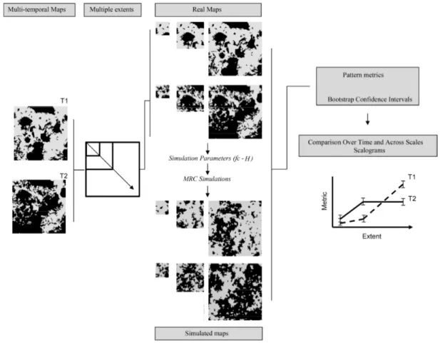
Per fornire un contesto statisticamente robusto all'interno del quale confrontare due paesaggi, sono necessarie delle repliche, dalle quali derivare stime, valori medi, intervalli di confidenza (Li e Wu 2007). In particolare, nella LPA, repliche del pattern spaziale considerato sono spesso non disponibili. Un strada percorribile per ottenere le suddette repliche (Capitolo 1), è quella di utilizzare modelli di simulazione del paesaggio (e.g. Neutral Landscape Models - Gardner et al. 1987; Saura e Martínez-Millán 2000). In particolare, i modelli, permettono di simulare un set di paesaggi i cui pattern spaziali hanno proprietà statistiche in comune (composizione e configurazione) con i paesaggi reali. Una volta simulate un numero sufficiente di repliche, sulle quali calcolare i diversi indici di pattern, è possibile ottenere distribuzioni empiriche per ogni indice. Tali distribuzioni vengono utilizzate per confrontare due o più paesaggi e determinare se, le differenze osservate in termini di indici di paesaggio, sono significative ad un determinato livello di confidenza. Nel Capitolo 2 viene adoperato un approccio simile al fine di determinare l'esistenza di scale spaziali significative (Wu et al. 2002), alle quali emergono determinati processi ecologici (p.es. ricolonizzazione naturale dei boschi sensu Sitzia et al. 2010). I risultati hanno messo in evidenza che i diversi processi di trasformazione del paesaggio (naturali o antropiche) si manifestano a scale spaziali specifiche.
Nelle prime due sezioni vengono proposti ed implementati nuovi approcci per quantificare ed analizzare il pattern spaziale del paesaggio. Il pattern spaziale o eterogeneità del paesaggio è costituito da due aspetti principali: la composizione e la configurazione (Turner et al. 2001). La composizione del paesaggio è data dal numero e dall’abbondanza relativa delle diverse tipologie di uso e copertura del suolo, mentre, la configurazione, rispecchia la loro struttura spaziale. La quantificazione del pattern spaziale è un aspetto fondamentale dell'ecologia del paesaggio in quanto permette di (i) monitorare e prevedere i cambiamenti temporali in un determinato paesaggio; (ii) confrontare paesaggi diversi e; (iii) analizzare il rapporto tra struttura e processi ecologici (p.es. distribuzione e movimento degli organismi, flusso di materia ed energia, propagazione del disturbo, etc. - Turner et al. 2001; Wu 2013). Uno degli approcci più diffusi per quantificare il pattern spaziale del mosaico consiste nel calcolo di metriche di paesaggio (landscape metrics) su cartografie tematiche (McGarigal 2013). Tuttavia l'applicazione efficace di tale approccio richiede una solida conoscenza dei principali limiti della Landscape Pattern Analysis (LPA) (Li e Wu 2007): (i) difficoltà nell'interpretazione di alcune metriche fortemente correlate o caratterizzate da relazioni non-lineari (p.es. Remmel e Csillag 2003; Neel et al. 2004; Long et al. 2010; Wang et al. 2014); (ii) complessità nell'analisi di alcune metriche caratterizzate da una consistente risposta multiscalare (Saura e Martinez-Millan 2001; Wu et al. 2002; Wu 2004); e (iii) incapacità di descrivere efficacemente la relazione tra pattern spaziale e processi ecologici (Turner et al. 2001); (iv) assenza di un contesto statisticamente robusto all'interno del quale confrontare il pattern spaziale di due paesaggi diversi oppure dei loro cambiamenti nel tempo (Remmel e Csillag 2003; Remmel e Fortin 2013). In particolare nel primo e secondo capitolo della prima sezione si propone lo sviluppo di metodi in grado di (i) fornire un contesto statisticamente robusto all'interno del quale confrontare il pattern spaziale di due paesaggi diversi oppure dei loro cambiamenti nel tempo (Remmel e Csillag 2003; Remmel e Fortin 2013) (Capitoli 1 – 2) e (ii) analizzare la dipendenza scalare del cambiamento del pattern (Saura e Martinez-Millan 2001; Wu et al. 2002; Wu 2004; Gergel 2007) (Capitolo 2).
vii
Per approfondimenti vedere:
Capitolo 1
FRATE L., CARRANZA M.L. 2013. Quantifying landscape-scale patterns of temperate forests over time by means of Neutral Simulation Models. ISPRS International Journal of Geo-Information 2 (1): 94-109. doi:10.3390/ijgi2010094.
Capitolo 2
FRATE L., SAURA S., MINOTTI M., DI MARTINO P., GIANCOLA G., CARRANZA M.L. 2014. Quantifying forest spatial pattern trends at multiple extents: an approach to detect significant changes at different scales. Remote Sensing 6: 9298-9315. doi:10.3390/rs6109298
Un’altra possibilità per svolgere confronti tra paesaggi in un contesto statisticamente robusto, consiste nell’impiego di un approccio di tipo campionario, grazie al quale derivare stimatori dei parametri di composizione e configurazione e i relativi intervalli fiduciari (Hassett et al. 2012; Stehman 2013). Nella seconda sezione, si adopera un approccio di tipo campionario per analizzare la frammentazione dei boschi nel tempo. La frammentazione è un processo che avviene a scala di paesaggio e consta di due componenti principali: la perdita di habitat (diminuzione della copertura) ed il cambiamento nella configurazione spaziale (pattern spaziale) (McGarigal et al. 2005). Esiste una vasta gamma di metriche di paesaggio in grado di quantificare la dimensione, la forma e l’isolamento delle patches di habitat in un paesaggio (p.es. McGarigal e Marks 1995), ma molte di esse sono fortemente correlate con la copertura dell’habitat (Neel et al. 2004). Confondere il cambiamento nel pattern spaziale con la predita di habitat può portare a conclusioni erronee e rende impossibile capire quale dei due aspetti è coinvolto nel processo di trasformazione di un paesaggio (Long et al. 2010; Wang et al. 2014). Per rispondere a tale quesito, nei capitoli 3 e 4 è stato proposto un metodo per lo studio della frammentazione delle foreste subtropicali che si basa sulla stima della copertura e configurazione spaziale delle foreste attraverso campionamento di cartografie derivate da immagini satellitari. Tramite tale applicazione è possibile ottenere una valutazione statistica sul contributo relativo della perdita delle foreste (forest loss) e del cambiamento della loro struttura spaziale (spatial pattern change) nel processo di frammentazione. In particolare, è stato adottato l’approccio proposto da Long et al. (2010), che prevede la costruzione di specifici spazi di relazione (relationship space) all’interno dei quali è possibile valutare in che misura la trasformazione del paesaggio è dovuto alla predita del bosco oppure al cambiamento del pattern spaziale. Inoltre, nel capitolo 4, le possibili ricadute di queste trasformazioni sulla biodiversità degli ecosistemi subtropicali è stata particolarmente enfatizzata.
Per approfondimenti vedere:
Capitolo 3:
CARRANZA M.L., FRATE L., ACOSTA A.T.R., HOYOS L., RICOTTA C., CABIDO M. 2014. Measuring forest fragmentation using multitemporal remotely sensed data: three decades of change in the dry Chaco European Journal of Remote Sensing 47. doi: 0.572/EuJRS2044746
viii
Per approfondimenti vedere:
Capitolo 5
FRATE L., CARRANZA M.L., HOYOS L.., ACOSTA A.T.R , CABIDO M. Temporal changes in I capitoli sinora presentati considerano il paesaggio secondo il paradigma Patch-Mosaic (Forman 1985) nel quale il paesaggio è un mosaico formato da elementi discreti (patches, matrici, corridoi). Nel capitolo 5, si è scelto di svolgere delle indagini in base ad un approccio complementare al precedente che tiene conto del contesto territoriale nel quale ogni elemento del paesaggio si trova (Landscape Context – e.g McGarigal and Cushman 2005). In particolare, si è scelto di estendere l'approccio della "context analisi multiscalare" (Riitters et al. 2000) all'analisi della frammentazione delle foreste nel tempo. Secondo questo approccio la qualità, la funzionalità e la persistenza degli elementi del paesaggio (p.es., pixel di bosco nel caso di cartografia raster, ecc.) sono fortemente condizionate dalle caratteristiche del mosaico territoriale che li circonda. In altre parole, ogni località classificata come bosco, viene definita sulla base del tipo di frammentazione che caratterizza il paesaggio circostante (p.es copertura e connettività). Quindi la frammentazione non è più vista come una proprietà stessa del bosco (p.es. dimensione e forma delle patches) ma come una proprietà del paesaggio che contiene bosco. Nella "context analysis" la scelta dell’estensione dell'area indagata ricopre un ruolo essenziale perchè i valori che le metriche di "context" assumono, dipendono dall’estensione del paesaggio indagato (extent). In questo capitolo, vengono analizzate le trasformazioni temporali in termini di copertura e connettività delle foreste subtropicali, a scale multiple (context di dimensioni diverse) che variano da scale locali (~ 5 ha) a scale regionali (~ 8000 ha) (sensu Riitters and Wickham 2012). I risultati mettono in evidenza la presenza di processi di frammentazione sia a scala locale che a scala regionale. Di conseguenza grandi distese di foresta sono diventate molto rare oppure completamente scomparse probabilmente come risposta ai cambiamenti nelle modalità di sfruttamento delle risorse imposti negli ultimi 30 anni da differenti livelli di organizzazione antropica (dallo sfruttamento locale dell'ambiente fino alla conversione completa di intere foreste che avviene a scale regionale e nazionale).
CARRANZA M.L., HOYOS L., FRATE L., ACOSTA A.T.R, CABIDO M. Measuring forest fragmentation using multitemporal forest cover maps: forest loss and spatial pattern analysis in the Gran Chaco, Central Argentina. Landscape and Urban Planning, under review.
forest spatial pattern at multiple extents: Patch, perforated, edge and interior forests in the Gran Chaco, Central Argentina. Ecosystems, submitted.
Da quanto descritto finora emerge che il paesaggio è un elemento dinamico in quanto soggetto a cambiamenti nello spazio e nel tempo e questi cambiamenti si verificano a scale differenti. I cambiamenti nella composizione e struttura del paesaggio hanno serie conseguenze sulla diversità biologica degli ecosistemi naturali e semi-naturali (Wiens 2002) ed, in particolare, il cambiamento della copertura e uso del suolo costituisce la più grande minaccia alla perdita della biodiversità a livello globale (Foley et al. 2005). Alterazioni nella struttura, composizione e funzione del paesaggio possono influenzare notevolmente la dimensione della popolazione (e popolamento), la loro distribuzione, le loro dinamiche (dispersione, movimento per la ricerca di cibo) e la loro persistenza (Gutzwiller 2002). In questo senso, L'Ecologia del Paesaggio, offre le basi teoriche, i concetti e gli strumenti necessari per studiare, monitorare e pianificare il territorio in relazione alle problematiche di conservazione della biodiversità (Wiens 2002). Proprio sulla base di queste considerazioni e di quelle effettuate nelle sezioni precedenti, la terza sezione è stata costruita come una raccolta di casi
ix
studio in cui, gli strumenti dell'Ecologia del Paesaggio, vengono applicati alla studio e conservazione di habitat e specie particolarmente minacciati. Nel Capitolo 6 vengono studiati gli effetti della frammentazione sulla biodiversità di flora vascolare in foreste temperate. In particolare vengono analizzate le relazioni tra il pattern spaziale (dimensione, geometria e grado di isolamento delle patches) di un habitat forestale tipico dei paesaggi appenninici italiani (Faggeti degli Appennini con
Taxus e Ilex – EU cod. 9210*) e le caratteristiche di tali formazioni, in termini di biodiversità
(composizione di flora vascolare e ricchezza di specie), struttura (Forme biologiche), strategie adattative (specie ruderali, di margine e specie di bosco - interior specialists) ed ecologia (bioindicatori di Ellenberg). I risultati confermano l'esistenza di un rapporto tra frammentazione e biodiversità dei boschi. In particolare le macchie grandi e ben connesse tendono ad ospitare un maggior numero di specie diagnostiche dell'habitat d'interesse comunitario (EU cod. 9210*) mentre nei boschi di piccola estensione sono presenti un numero elevato di specie di margine. Inoltre, gli indicatori strutturali ed ecologici hanno messo in evidenza una qualità ambientale superiore nelle macchie di foresta estese.
Per approfondimenti vedere:
Capitolo 6
CARRANZA M.L., FRATE L., PAURA B. 2012. Structure, ecology and plant richness patterns in beech forests. Plant Ecology and Diversity 5: 541-551. doi: 10.1080/17550874.2012.740509
Nel capitolo 7, si affronta la problematica della conservazione di specie volatrici in relazione alla presenza di impianti eolici sul territorio. Attraverso la costruzione di modelli di distribuzione (SDM – p.es., Franklin 2013) per due specie di chirotteri (Nycatlus leisleri e Pipistrellus pipistrellus) sono state costruite delle cartografie dell'habitat di foraggiamento ottimale delle specie. L'analisi della distribuzione degli impianti eolici in relazione all'habitat delle specie ha messo in evidenza l'esistenza di aree critiche per la loro conservazione. La presenza di fattorie eoliche costituisce un'importante minaccia per le specie indagate in quanto porta ad un processo di frammentazione (incisione, dissezione e perforazione) del loro habitat.
Per approfondimenti vedere:
Capitolo 7
ROSCIONI F., RUSSO D., DI FEBBRARO M., FRATE L., CARRANZA M.L., LOY A. 2013. Regional-scale modeling of the cumulative impact of wind farms on bats. Biodiversity and Conservation, 22 (8): 1821-1835. doi: 10.1007/s10531-013-0515-3.
Il Capitolo 8, indaga sulla conservazione e la gestione degli habitat di duna costiera tenendo conto delle loro valenze sia in termini di biodiversità floristica che di fauna. Nello specifico vengono analizzate cartografia digitale di dettaglio relativa agli habitat d’interesse conservazionistico (Direttiva Habitat 92/437CEE) con dati radiotelemetrici di Testudo hermanni come esempio di specie di fauna minacciata (EN IUCN 2014) e caratteristica di questi habitat. L'analisi dell’”habitat preference" (Manly et al. 2002) ha messo in evidenza una stagionalità nella scelta delle tipologia di vegetazione da parte della Testudo di Hermann che risponde alle diverse esigenze trofiche, di termoregolazione e riproduttive durante l'anno.
Per approfondimenti vedere:
x
Nel capitolo 9, si analizza la riposta del paesaggio vegetale di alta quota al riscaldamento climatico globale. Vengono studiate la trasformazioni della vegetazione sommitale avvenuta durante gli ultimi 10 anni sulle vette italiane (Appennino centrale e Alpi Sudorientali - rete LTER). I risultati mostrano che i paesaggi di alta quota tendono ad arricchirsi di specie provenienti da piani vegetazionali inferiori (termofilizzazione) e caratterizzate da strategie di riproduzione vegetativa (emicriptofite e camefite).
Per approfondimenti vedere:
Capitolo 9
STANISCI A., FRATE L., MORRA DI CELLA U., PELINO G., PETEY M., SINISCALCO C., CARRANZA M.L. 2014. Short-term signals of climate change in Italian summit vegetation: observations at two GLORIA sites. Plant Biosystems. doi: 10.1080/11263504.2014.968232
Nel capitolo 10 viene proposta e testata una procedura per la cartografia dell’età dei boschi in base a immagini telerilevate e modelli alsometrici. Nella regione Molise, i boschi si presentano come un mosaico dinamico composto da patches riferibili a diversi stadi di successione ecologica (Gustafson e Diaz 2002). Alcune tipologie forestali, come i boschi di roverella presentano valori di età piuttosto bassi (meno di 30 anni), mentre i boschi di faggio e cerro presentano una distribuzione per classi di età più ampia e generalmente sono caratterizzate da stadi seriali più maturi (dai 10 a >120 anni).
Per approfondimenti vedere:
Capitolo 10
FRATE L., CARRANZA M.L., DI FEBBRARO M., GARFI V., TONTI D., MARCHETTI M., BERARDO F., CARRANZA M.L., FRATE L., STANISCI A., LOY A. Seasonal habitat preference by the flagship species Testudo hermanni and implications for the conservation of coastal dune EU habitats. Journal for Nature Conservation, submitted.
OTTAVIANO M., CHIRICI G. Spatially explicit estimation of forest age integrating remotely sensed data and inverse yield modeling techniques. iForest, submitted.
xi
Nella presente ricerca, sono state affrontate numerose problematiche relative all’analisi delle trasformazioni del pattern spaziale nel tempo e alla conservazione della biodiversità di differenti habitat e specie particolarmente minacciati da fattori ambientali ed antropici.
Per l'analisi delle trasformazioni nel tempo sono state proposte delle procedure e delle nuove metodologie che permettono il confronto tra paesaggi in un contesto statisticamente robusto. Per il confronto statistico sia fatto ricorso sia a repliche derivate da paesaggi simulati sia da campionamento di paesaggi reali. In queste analisi il paesaggio è rappresentato da un mosaico di elementi discreti (Patches, corridoi, matrici, ecc.) secondo il paradigma Patch-Mosaic il quale offre una rappresentazione efficace, relativamente semplice e molto utile per l’analisi di diversi processi ecologici come la ricolonizzazione naturale, la frammentazione e per il monitoraggio dei cambiamenti del pattern nel tempo.
Come prima proposta, è stata presentata una nuova procedura adatta a confrontare statisticamente il pattern spaziale del paesaggio nel tempo che si basa sull’utilizzo di paesaggi simulati attraverso modelli di simulazione neutrale (Neutral Landscape Moodels). L’approccio proposto si è dimostrato particolarmente efficace in quanto ha permesso di: (i) ottenere un set di paesaggi che simulano in maniera adeguata il pattern spaziale delle foreste e il suo cambiamento nel tempo, direttamente confrontabili con paesaggi reali; (ii) rappresentare le informazioni più rilevanti del processo indagato; (iii) ottenere repliche che sono statisticamente simili ai paesaggi reali e quindi permettendo il loro confronto statistico. Inoltre, l’estensione di tale approccio alla dimensione multiscalare ha: (iv) fornito una più accurata comprensione della relazione esistente tra pattern e processi; e (v) permesso di evitare gli errori potenzialmente introducibili nelle analisi a scale singole che ignorano le informazioni sulla distribuzione e la variabilità delle metriche di pattern.
Tuttavia questo tipo di approccio può presentare dei limiti legati essenzialmente a: (i) la correlazione tra i parametri di pattern (metriche) e la composizione del paesaggio (abbondanza); e (ii) la difficoltà dei modelli di simulazione (NLMs) nel riprodurre alcuni paesaggi dove i fattori ambientali ed antropici generano mosaici con strutture complesse (es. forme lineari e allungate). Per quanto riguarda la prima limitazione, al fine di indagare la relazione tra pattern spaziale e composizione e le rispettive trasformazioni nel tempo, è stata proposta una nuova metodologia che prevede la costruzione di appositi "spazi di relazione". Gli spazi di relazione mettono in confronto i valori che assumono le metriche di pattern e i rispettivi valori di copertura (composizione). La costruzione degli “spazi di relazione” si è rilevata una strumento efficace per valutare il contributo relativo di composizione e configurazione, al processo di frammentazione nel tempo, specialmente per quelle metriche che presentano relazioni non monotoniche.
Come possibile alternativa per superare le eventuali limitazioni proprie dei NLMs, durante il presente progetto di ricerca è stata testata la possibilità di svolgere il confronto statistico, non più basato su simulazioni di paesaggi ma attraverso stimatori (media, deviazione standard) derivati dal campionamento di paesaggi reali. Il campionamento di serie temporali di cartografia telerilevata ha permesso di (i) ottenere stime non distorte delle metriche di pattern spaziale e del relativo cambiamento nel tempo; (ii) fornire le basi per il monitoraggio costante nel tempo del processo di frammentazione; (iii) valutare le trasformazioni (traiettorie) in uno spazio di relazione che descrive le caratteristiche spaziali (pattern e composizione) specifiche dei territori indagati.
Durante la ricerca si è anche tentato di testare dei metodi di analisi spaziale che tengono conto della gradualità caratteristica di molti processi ecologici e delle sfumature e transizioni che caratterizzano
xii
i paesaggi reali. Tra questi metodi la "context analysis", capace di descrivere la composizione e la connettività del contesto territoriale nel quale si trova ogni elemento di paesaggio, costituisce una valida alternativa al Patch-Mosaic model per l’analisi della frammentazione. In particolare, la context analysis (i) offre una rappresentazione realistica della natura sfumata di numerosi processi ecologici; e (ii) fornisce una misura diretta della scala spaziale alla quale i processi ecologici avvengono (connettività e composizione variano in funzione del paesaggio circostante o extent incluso nell’analisi).
Infine, le ricerche svolte nell'ambito della conservazione della biodiversità di habitat e di specie hanno confermato le grandi potenzialità dell’Ecologia del paesaggio nell’orientare ed ottimizzare le misure necessarie per una gestione sostenibile dei diversi ecosistemi. L’Ecologia del Paesaggio continua ad offrire strumenti efficaci per lo studio e il monitoraggio dell’eterogeneità spaziale, per lo studio della relazione tra pattern e processi e per la conservazione della biodiversità. Si tratta di una disciplina in continua evoluzione. Il presente lavoro di tesi ha confermato le potenzialità dell’Ecologia del Paesaggio ed ha fornito nuovi elementi che contribuiscono a rispondere ad alcune delle sue grandi sfide per il futuro. Ad esempio il contributo alle conoscenze sulle relazioni che intercorrono tra il mosaico spaziale (e quindi la sua quantificazione) e i processi ecologici (p.es. frammentazione, dispersione e movimento di organismi) risponde alla necessità di avere strumenti adeguati per definire misure di conservazione e piani di gestione capaci di migliorare il destino degli habitat naturali e semi-naturali e delle specie che ospitano.
Bibliografia
FAO. 2012. State of the World's Forests 2012. Food and Agricultural Organization of the United Nations, Rome, Italy. http://www.fao.org/docrep/016/i3010e/i3010e00.htm (Retrieved 05/12/2014).
Foley J.A., Defries R., Asner G.P., Barford C., Bonan G., Carpenter S.R., Chapin F.S., Coe M.T., Daily G.C., Gibbs H.K., et al. 2005. Global consequences of land use. Science 309:570-574.
Forman R.T.T. 1985. Land Mosaics: The Ecology of Landscapes and Regions. Cambridge University Press, Cambridge, United Kingdom.
Forman R.T.T., Godron M. 1986. Landscape Ecology. Wiley.
Frankiln J. 2013. Species distribution models in conservation biogeography: developments and challenges. Diversity and Distribution 19: 1217-1223.
Gardner R.H., Milne B.T., Turner M.G., O'Neill R.V. 1987. Neutral models for the analysis of broad-scale landscape patterns. Landscape Ecology 1: 19-28.
Gergel S.E. 2007. New direction in landscape pattern analysis and linkages with remote sensing. In: Wulder M.A., Franklin S.E. (Eds.) Understanding Forest Disturbance and Spatial Pattern: Remote Sensing and GIS Approaches. Taylor and Francis: Boca Raton, FL, USA: pp. 173-208.
Gustafson E.J., Diaz N. 2002. Landscape Pattern, Timber Extraction, and Biological Conservation. In: Gutzwiller K.J. (Ed.) Applying Landscape Ecology in Biological Conservation. Springer-Verlag, New York (USA): pp 244-265.
Gutzwiller K.J. 2002. Conservation in Human-altered Landscapes: Introduction to Section III. In: Gutzwiller K.J. (Ed.) Applying Landscape Ecology in Biological Conservation. Springer-Verlag, New York (USA): pp 195-197.
xiii
Hassett E.M., Stehman S.V., Wickham J.D. 2012. Estimating landscape pattern metrics from a sample of land cover. Landscape Ecology 27: 133-149.
Li H., Wu J. 2007. Landscape pattern analysis: key issues and challenges. In: Wu J., Hobbs R.J. (Eds.) Key Topics in Landscape Ecology. Cambridge University Press, Cambridge (UK): pp39-61.
Long J.A., Nelson T.A., Wulder M.A. 2010. Characterizing forest fragmentation: Distinguishing change in composition from configuration. Applied Geography, 30: 426-435.
Manly B.F.J, McDonald L.L., Thomas D.L., McDonald R.L., Erickson W.P. 2002. Resource selection by animals: statistical design and analysis for field studies. Kluwer Academic Publisher, Dordrecht, Netherlands.
McGarigal K. 2013. Landscape pattern metrics. In: El-Shaarawi A.H., Piegorsch W. (Eds.). Encyclopedia of Environmetrics, Second Edition. John Wiley & Sons Ltd, Chichester (UK): pp. 1441-1451.
McGarigal K., Cushman S., Reagan C. 2005. Quantifying Terrestrial Habitat Loss and Fragmentation: A Protocol. USDA General Technical Report; USDA, Rocky Mountain Region: Golden, CO, USA.
McGarigal K., Cushman S.A. 2005. The Gradient Concept of Landscape Structure. In: Wiens J., Moss M. (Eds.) Issues and Perspectives in Landscape Ecology. Cambridge University Press: Cambridge (UK): pp. 112-119.
McGarigal K., Marks B.J. 1995. FRAGSTATS: Spatial Pattern Analysis Program for Quantifying Landscape Structure. General Technical Report PNW-GTR-351, USDA, Forest Service, Pacific Northwest Research Station: Portland, OR, USA.
Neel M.C., McGarigal K., Cushman S.A. 2004. Behavior of class level landscape metrics across gradients of class aggregation and area. Landscape Ecology 19: 435–455.
Remmel T.K., Fortin M-J. 2013. Categorical, class-focused map patterns: Characterization and comparison. Landscape Ecology 28: 1587-1599.
Remmel TK, Csillag F. 2003. When are two landscape pattern indices significantly different? Journal of Geographical Systems 5: 331-351.
Riitters K.H., Wickham J. 2012. Decline of forest interior conditions in the conterminous United States. Scientific Report 2, 653.
Riitters K.H., Wickham J., O'Neill R., Jones B., Smith E. 2000. Global-Scale Patterns of Forest Fragmentation. Ecology and Society 4(2): 3.
Rudel TK, Coomes O.T., Moran E., Achard F., Angelsen A., Xu J., Lambin E. 2005. Forest transitions: towards a global understanding of land use change. Global Environmental Change 15:23-31.
Saura S., Martínez-Millán J. 2000. Landscape patterns simulation with a modified random clusters method. Landscape Ecology15: 661-678.
Saura S., Martínez-Millán J. 2001. Sensitivity of lanscape pattern metrics to map spatial extent. Photogrammetric Engineering & Remote Sensing 67: 1027-1036.
Sitzia T., Semenzato P., Trentanovi G. 2010. Natural reforestation is changing spatial patterns of rural mountain and hill landscapes: A global overview. Forest Ecology and Management 259: 1354-1362.
xiv
Stehamn S.V. 2013. Sampling strategy for forest monitoring from global to national levels. In: Achard F., Hansen M.C. (Eds.) Global Forest Monitoring From Earth Observations. CRC Press, Boca Raton, Florida, USA: pp.65-92
Turner M.G., Gardner R.H., O'Neill R.V. 2001. Landscape Ecology in Theory and Practice. Springer-Verlag, New York.
Wang X., Blanchet F.G., Koper N. 2014. Measuring habitat fragmentation: An evaluation of landscape pattern metrics. Methods in Ecology and Evolution. doi:10.1111/2041-210X.12198.
Wiens J.A. 2002. Central concepts and issues of landscape ecology. In: Gutzwiller K.J. (Ed.) Applying Landscape Ecology in Biological Conservation. Springer-Verlag, New York (USA): pp 1-34.
Wu J. 2004. Effects of changing scale on landscape pattern analysis: scaling relations. Landscape Ecology 19: 125-138.
Wu J. 2013. Key concepts and research topics in landscape ecology revisited: 30 years after the Allerton Park workshop. Landscape Ecology 28:1-11.
Wu J., Shen W., Sun W., Tueller P.T. 2002. Empirical patterns of the effects of changing scale on landscape metrics. Landscape Ecology 17: 761-782.
xv
RINGRAZIAMENTI
Molte persone hanno contribuito alla presente tesi e, senza il loro appoggio, questo lavoro non sarebbe stato possibile. Innanzitutto vorrei ringraziare Maria Laura Carranza per la curiosità e la passione che mi ha trasmesso verso la ricerca, per le sue critiche e suggerimenti, per il nostro continuo confrontarci. È soprattutto grazie a lei che in questi tre anni sono riuscito a raggiungere gli obiettivi che mi ero prefissato e a crescere sotto il profilo professionale e anche umano.
Sono davvero tantissime le altre persone che hanno contribuito alla realizzazione dei lavori riportati in questa tesi: Alicia A.T.R. Acosta, Fabiana Berardo, Marcelo Cabido, Gherardo Chirici, Mirko Di Febbraro, Paolo Di Martino, Vittorio Garfì, Carmen Giancola, Laura Hoyos, Anna Loy, Marco Marchetti, Michele Minotti, Umberto Morra Di Cella, Bruno Paura, Giovanni Pelino, Martina Petey, Carlo Ricotta, Federica Roscioni, Giovanni Santopuoli, Santiago Saura, Consolata Siniscalco, Angela Stanisci, Danilo Russo, Daniela Tonti, ai quali va un immenso grazie.
Come non poter ringraziare tutti gli altri dottorandi e non che hanno condiviso con me questa esperienza, tutti i ragazzi dell’Envix-Lab e degli altri laboratori del Dipartimento di Bioscienze e territorio (mi scuso in anticipo se ho dimenticato qualcuno): Durante Aquino, Emanuele Conte, Evelina D’Alessandro, Giuseppina De Castro, Maria Carla De Francesco, Lorenzo De Lisio, Laura Ducci, Mita Drius, Massimiliano Foresta, Alberto Evangelista, Francesco Iannotta, Bruno Lasserre, Matteo Mura, Angela Pitassi, Lorenzo Sallustio, Angelo Vitone, Matteo Vizzarri.
Un ringraziamento speciale va alla mia famiglia e alle persone vicine a me che mi hanno supportato e “sopportato” in questi lunghi tre anni.
Infine, vorrei ringraziare l’Università Degli Studi del Molise che ha supportato finanziariamente la mia attività di ricerca nell’ambito del progetto di dottorato.
xvi
CONTENUTI
1
Capitolo 1. Quantifying Landscape-Scale Patterns of Temperate Forests Over Time by Means of Neutral Simulation Models
2
FRATE L.,CARRANZA M.L.
Capitolo 2. Quantifying Forest Spatial Pattern Trends at Multiple Extents: An Approach to Detect Significant Changes at Different Scales
19
FRATE L.,SAURA S.,MINOTTI M.,DI MARTINO P.,GIANCOLA C.,M.L.CARRANZA
38
Capitolo 3. Measuring forest fragmentation using multitemporal remotely sensed data: three decades of change in the dry Chaco
39
CARRANZA M.L.,FRATE L.,ACOSTA A.T.R.,HOYOS L., RICOTTA C.,CABIDO M.
Capitolo 4. Measuring forest fragmentation using multitemporal forest cover maps: forest loss and spatial pattern analysis in the Gran Chaco, Central Argentina
52
CARRANZA M.L.,HOYOS L.,FRATE L.,ACOSTA A.T.R., CABIDO M.
Capitolo 5. Temporal changes in the fragmentation context of forests at multiple extents: Patch, perforated, edge and interior forests in the Gran Chaco, Central Argentina
85
FRATE L.,CARRANZA M.L.,ACOSTA A.T.R.,HOYOS L., CABIDO M.
Sezione III. Applying Landscape Ecology in Biological Conservation 115
Capitolo 6. Structure, Ecology and Plant Richness Patterns in Fragmented Beech Forests
116
CARRANZA M.L.,FRATE L.,PAURA B.
Capitolo 7. Regional-Scale Modelling of the Cumulative Impact of Wind Farms on Bats.
128
ROSCIONI F.,RUSSO D.,DI FEBBRARO M.,FRATE L., CARRANZA M.L.,LOY A.
Sezione II. Measuring Forest Fragmentation Over Time: Applications in Subtropical Forest Landscapes
Abstract (iii)
Prefazione (v)
Ringraziamenti (xv)
Sezione I. When Are Two Landscapes Significantly Different? Applications in Temperate Forest Landscapes
xvii
Capitolo 8. Seasonal Habitat Preference by the Flagship Testudo hermanni. Implications for the Conservation of Coastal Dune EU Habitats
144
BERARDO F.,CARRANZA M.L.,FRATE L.,STANISCI A.,LOY A.
Capitolo 9. Short-term Signals of Climate Change in Italian Summit Vegetation: Observations at Two GLORIA Sites
167
STANISCI A.,FRATE L.,MORRA DI CELLA U.,PELINO G., PETEY M.,SINISCALCO C.,CARRANZA M.L.
Capitolo 10. Spatially Explicit Estimation of Forest Age by Integrating Remotely Sensed Data and Inverse Yield Modeling Techniques
177
FRATE L.,CARRANZA M.L.,GARFÌ V.,DI FEBBRARO M., TONTI D.,MARCHETTI M.,OTTAVIANO M.,SANTOPUOLI G., CHIRICI G.
1
When Are Two Landscapes Significantly Different?
Applications in Temperate Forest Landscapes
2
FRATE L., CARRANZA M.L. 2013. Quantifying landscape-scale patterns of
temperate forests over time by means of Neutral Simulation Models. ISPRS
International Journal of Geo-Information 2 (1): 94-109. doi:10.3390/ijgi2010094
.ISPRS International
Journal of
Geo-Information
ISSN 2220-9964 www.mdpi.com/journal/ijgi/ ArticleQuantifying Landscape-Scale Patterns of Temperate Forests
over Time by Means of Neutral Simulation Models
Ludovico Frate and Maria Laura Carranza *
EnviX-Lab, Dipartimento di Bioscienze e Territorio (BiT), Università degli studi del Molise, C.da Fonte Lappone, 86090 Pesche (IS), Italy; E-Mail: [email protected]
* Author to whom correspondence should be addressed; E-Mail: [email protected];
Tel.: +39-874-404-185; Fax: +39-874-404-123.
Received: 1 January 2013; in revised form: 19 February 2013 / Accepted: 21 February 2013 / Published: 1 March 2013
Abstract: Several studies attempt to describe changes in the spatial patterns of forests over
time, resorting to the comparison of landscape pattern indices (LPI), but new methods for quantifying landscape differences in a statistical context are necessary. In this paper, we quantified and assessed the statistical significance of the forests pattern changes, which have occurred since the end of WWII in Central Italy (Isernia). To do this; based on the proportion of forest cover (pi) and contagion (H) of three land cover maps (1954–1981–2006); we generated 100 forest maps with predictable results through the midpoint displacement algorithm. Then, for both observed and simulated maps, we computed a set of LPI (number of patches, cohesion, largest forest patch index and area weighted mean shape index) and we derived their empirical distributions; finally, we compared the empirical distributions using the non-parametric Kruskal-Wallis test. Our results show significant changes in the spatial pattern of forests and underline the process of natural forest re-growth, which, in the area, is constrained by ―remnants‖ of traditional activities. The adopted approach could be extended to a large ensemble of landscapes and spatial scales and could become a standard procedure when comparing patterns in time.
Keywords: midpoint displacement algorithm; landscape pattern index; empirical
1. Introduction
Landscapes change in both structure and function [1] and said dynamism is mainly driven by changes in management practices responding to social, political and economic forces [2]. The analysis of temporal and spatial changes represents one of the most challenging problems in landscape ecology. Describing changes in different land cover types through time may be crucial, both for preserving biological diversity and related ecosystem services, and for developing general landscape models, which are useful in ecosystem management and environmental policies [3,4]. The current state of landscape patterns in the world is mainly the result of centuries of evolution in land use [5]. For instance, temperate forests in mountain and hilly landscapes of Europe are currently distributed in a mosaic, which is derived not only from centuries of extensive forest exploitation, but also from agriculture and cattle farming [6–8], followed by a recent, spontaneous reforestation process, which occurred after the World War II rural exodus and the consequent abandonment of traditional agricultural practices [9–14].
The quantitative, spatial and temporal analysis of natural forest re-growth in abandoned farmlands has acquired increasing relevance due to the effects of forest expansion on many important ecosystem functions [11]. For example, forest expansion affects hydrological cycles and soil dynamics [15], climate [16,17] and biodiversity [11,18,19] at different scales. Several landscape metrics have been developed to quantify forest patterns in terms of space and time, most of which have been tested on grid-based thematic maps [5,20–22]. Studies aimed at quantifying forest distribution frequently employ landscape pattern indices (LPI) to measure changes in both forest cover and pattern. Changes over time are assessed by many authors simply through the comparison of LPI [23–25]. Current research suggests that the comparison of raw LPI values should be avoided [26], since they are sensitive to scale [27], land cover proportions [28], spatial resolution [29,30], spatial extent [31] and land-cover misclassification [32]. New methods for comparing LPI values may be useful in order to add statistical context to landscape pattern analysis [27,33]. As at present it is possible to clearly identify and quantify the differences between any two given dates, the statistical significance of the observed changes remains the most important and complex challenge with which to deal [28,34]. In order to enrich landscape pattern analysis with statistical significance, new methods for comparing and testing LPI values have been proposed [34–36]. In ecological research, at the landscape scale, replication cannot be considered, and consequently, distribution, expected values and variance are not available; ecologists who want to perform statistically robust comparisons of landscapes among different maps must rely upon simulations based on computer-generated models able to reproduce an expected pattern, which shares statistical properties with an empirical pattern of interest [34,35,37].
Among the spatial models developed in landscape ecology, the neutral models (NLMs) are those able to produce an expected pattern in the absence of specific landscape processes [21,38–42], providing a baseline in order to evaluate the influence of landscape heterogeneity on ecological processes and vice versa [42]. The first neutral model in landscape ecology was the simple random map developed from percolation theory [39,43] and created by randomly assigning habitats to a proportion, pi, of a grid map [39]. Subsequently, the evolution of NLMs followed the development of fractal methods applied to percolation maps [42]. The second generation of NLMs were hierarchical, random landscapes, generated by fractal curdling [44]. Both the above-mentioned NLMs assume a
complete spatial independence from the habitat (or cells in a map) throughout a landscape. Since, in real-life landscapes, habitats usually show a certain degree of spatial contagion, another fractal algorithm, specifically the ―midpoint displacement algorithm‖ [45] has been proposed, giving way to a third generation of NLMs, whose surfaces exhibit continuous environmental variability. Successively, many attempts to test their usefulness in various fields of research have been made. The NLMs based on the midpoint displacement algorithm have been used to assess the effect of landscape fragmentation on population distribution [46], dispersal success of communities [47], insect movement patterns [48] and biodiversity [49]. They were also used to model the diffusion of contamination in aquatic environments [38], the influence of correlated spatial patterns on species coexistence of plant communities [50] and the spatial pattern of disturbance [51] at different scales [52,53]. Although, initially, many NLMs were theoretically applied [54], several efforts toward modeling complex landscapes and testing their differences using neutral fractals have been made [35,55,56]; therefore, we are confident that such an approach can be applied to landscape comparison over time, while carrying out a statistical significance assessment.
Considering the aforementioned points, the present work aims to describe forest cover dynamics in the hilly landscapes of Central Italy in the last 60 years, analyzing the spatial pattern of temperate forest patches of the area surrounding a small city in a rural European setting in detail (Isernia municipality). In particular, we focus on two questions:
(1) How did the spatial pattern of temperate forests change over time (1954–1981–2006)? (2) Is the spatial pattern change of these forests significantly different over time?
To properly handle such an issue, on one hand, we used a set of landscape pattern indices to describe the forest spatial pattern dynamics and, on the other hand, we compared LPI of real and simulated landscapes to assess the statistical significance of any possible differences. In order to simulate fractal maps, we chose the midpoint displacement algorithm, because it looks very promising for modeling the natural reforestation process, which occurs in many hilly landscapes, as it is able to represent continuous autocorrelated pattern variations [40]. In particular, this fractal NLM allows, through the variation of both proportion and spatial contagion, the obtaining of different levels of habitat aggregation and patchiness [57]. In order to better understand the dynamics of forest fragments and to offer the basis for pinpointing specific conservation actions and forest management strategies for temperate forests in Europe, a multi-temporal analysis, which takes into account the statistical significance of differences in landscape, should be implemented.
2. Methods 2.1. Study Area
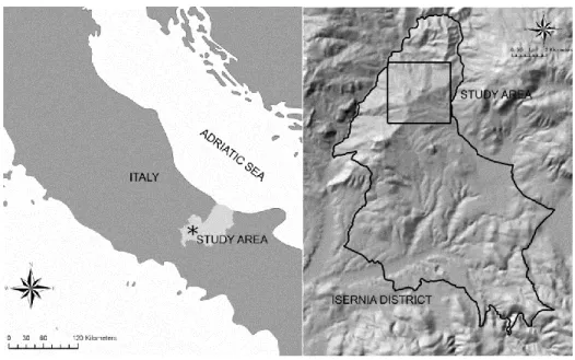
Isernia (Central Italy) was selected for our analysis (Figure 1), because the abandonment of traditional rural activities in this area, along with recent developments in infrastructure, appear to have caused changes in land cover, which are typical of small cities in many areas of Italy and other Mediterranean countries [58]. Furthermore, the municipality of Isernia represents a pilot study area of a larger project aimed at analyzing the landscape dynamics of rural areas, which have occurred since the end of World War II in Central Italy. Isernia covers ca. 68 ha and, at present, consists of a small
continuous urban area (22,000 inhabitants) surrounded by a hilly landscape with agricultural, semi-natural and natural land cover types: olive groves, crop fields, complex cultivation patterns and broad-leaved forests (mainly Quercuspubescens and Quercuscerris woodlands). Although these forests are very important from a conservation point of view (―Pannonian-Balkanic turkey oak-sessile oak forests‖ according to ―Habitat Directive‖ EEC 43/92), no protected areas exist in Isernia. Altitudes range from 291 m above mean sea level (a.m.s.l.) to 906 m a.m.s.l., and the climate is temperate [12]. During the last half century, almost 50% of the territory has changed, mainly due to an evolution in landscape management trends: agricultural intensification in the alluvial plains and abandonment of traditional land use activities on the reliefs and less accessible areas [58]. In 1955, the study area was characterized by widespread agricultural lands accompanied by natural and semi-natural vegetation patches of broadleaved forests, thickets and pastures. On the contrary, more recently, broad-leaved forest cover increased in less accessible and hilly areas, substituting shrub lands, part of pre-existing grasslands and olive groves [58].
Figure 1. Map showing the Isernia district (Italy) and the location of the study area.
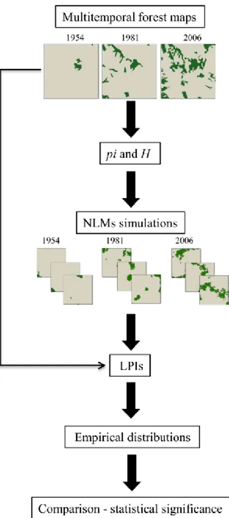
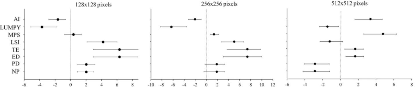
2.2. Data Analysis
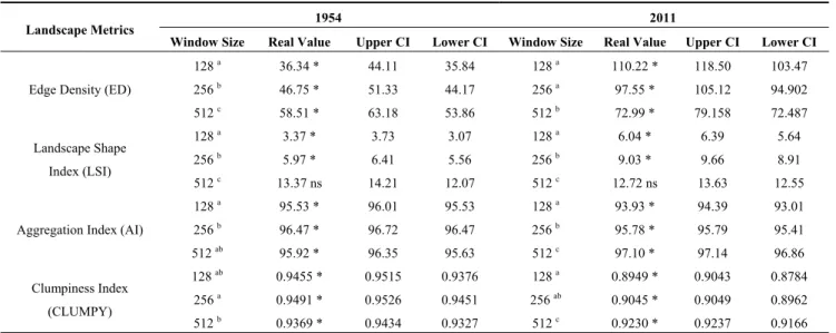
We analyzed the spatial pattern of forests and assessed the significance of the observed differences over time, following the general framework proposed by Remmel and Csillag [35], as described in Figure 2.
2.2.1. Data Preparation
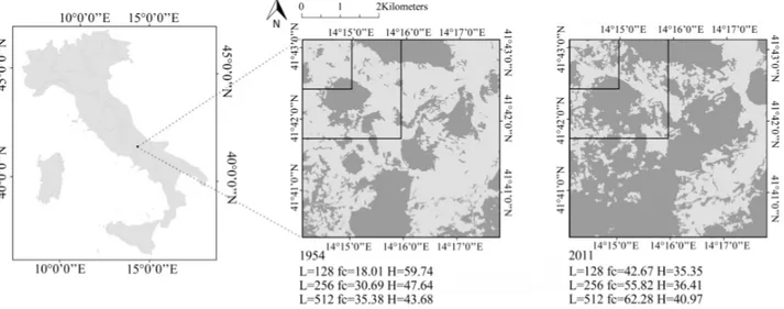
Three land cover maps, relative to the years 1954, 1981 [58] and 2006 (1:25,000), derived from aerial photographs, were used to perform the landscape pattern analysis at the regional scale (see Acosta et al. [58]).
Due to the fact that the midpoint displacement algorithms can generate only square maps [55], we delineated a representative (approximately 20% of hilly sectors of Isernia) 256 × 256 pixel square area, which was used to extract the same geographical window from each map to be compared in time
(Figure 3). Next, land cover maps were rasterized with a spatial resolution of 10 m and reclassified in two categories: broadleaved oak forests and other cover types (arable land, permanent crops, pastures, shrub and herbaceous vegetation).
Figure 2. Proposed framework for comparing and testing differences of forest pattern
over time.
Figure 3. Three forest cover maps extracted from a multitemporal dataset of Isernia, Italy.
Each image is 256 × 256 pixels, with a spatial resolution of 10 m. The binary classification separates oak forest (dark green) from other cover types (arable land, permanent crops, pastures, shrub and herbaceous vegetation—soft grey). pi indicates the proportion of forest cover; H is the autocorrelation of the map. (a) = 1954; (b) = 1981; (c) = 2006.
2.2.2. NLM
Firstly, two parameters necessary for running the NLM simulations were calculated for each date (1954, 1981 and 2006): proportion of forest cover (pi) and contagion (H). pi is given by the number of forested cells in relation with the total number of cells present in the landscape and ranges between 0 (no forest cover) and 1 (whole landscape covered by forests). H, or contagion [59], describes the adjacencies of forest ―cells‖ and ranges from 0, when forest distribution is maximally disaggregated (no adjacencies among cells of the same class), to 100, when landscape is totally covered by forests (only forest-to-forest adjacencies). Next, for each above mentioned map, we generated 100 maps using the public domain software Qrule [57], freely available on-line (http://www.al.umces.edu/ faculty/bobgardner.html). Fractal landscapes were generated using the midpoint displacement algorithm [45], as described in With [60] and With et al. [46]. In short, for each simulation, a three-dimensional fractal surface with roughness controlled by H was created by the midpoint displacement algorithm; then, every fractal surface was sectioned at the appropriate elevation to create a two-dimensional landscape map with the requisite amount of forest given by pi. Finally, in order to avoid the ―salt and pepper‖ artifact commonly present in fractal maps [55] and to make simulated maps comparable with real landscapes [56], we deleted all the patches smaller than the minimum mapping unit of the original maps [61]. The removal of small patches didn’t significantly affect the proportion of forest cover (pi reduction < 0.5%).
2.2.3. LPI Calculation
To analyze the spatial pattern of forests through time, a set of landscape pattern indices on both real and simulated maps was calculated by using FRAGSTATS 4.0 [62]. After recording the total number of patches of forest (NP), we focused on the other three class landscape metrics, which had been previously reported as ecologically meaningful [22,63] and have been proven to be useful in describing patch spatial structure in a forested landscape context [64–69]: largest forest patch index (LFP), area weighted mean shape index (AWMSI) and patch cohesion index (COHESION). NP and LFP were selected, because they are related to forest fragmentation [33,66,67,70], defined as the breaking up of one large forest area into many smaller patches [71]. The largest forest patch index (LFP) quantifies the percentage of total landscape area comprised by the largest forest patch. As the diminution of LFP over time is one of the most effective metrics for measuring forest fragmentation [67], its increment could be an effective indicator for describing the reverse process [72,73]. AWMSI [74] measures the complexity of patch shape compared to a standard shape that, in raster format, attains its minimum value (AWMSI = 1) for squares. AWMSI values increase for more irregular and elongated shapes. We chose AWMSI, because of its capacity to distinguish between big, round-shaped patches, characteristic of well-preserved forests, and small, irregular patches, which often dominate in disturbed landscapes (for a review, see Haines-Young and Chopping [64]). COHESION measures the physical connectedness of forests and is commonly used for describing habitat connectivity [75,76]. In conditions of natural forest re-growth, an increment in time of landscape cohesion and connectivity could be expected [69]. COHESION, which ranges between 0 and 100, is minimal when the proportion of the forested landscape decreases and becomes increasingly subdivided and less physically connected. On the other
hand, COHESION increases as the proportion of the landscape covered by forests increases (see McGarigal and Marks [74] for details).
2.2.4. Comparing Observed and Simulated LPI
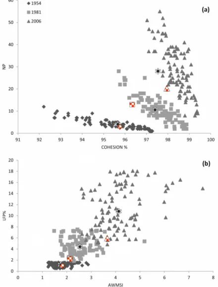
By computing the selected LPI (NP, LFP, AWSI and COHESION) on simulated landscapes, their empirical distributions (sensu Fortin et al. [77]) for each date were obtained. First, we verified the ability of the midpoint displacement algorithm to produce plausible patterns and underlying processes by generating scatterplots that include LPI derived from both real and simulated maps (Figure 4). In particular, the following LPI-based two-parameter spaces were built: NP vs. COHESION and LFP vs. AWMSI. Then, we quantified the differences of LPI among the three dates (1954, 1981 and 2006) by performing a Kruskal-Wallis test, followed by a Mann-Whitney post-hoc pairwise test.
Figure 4. Scatter plots among two paired combinations of observed landscape pattern
indices (LPI) values for simulated landscapes (N = 100; 1954, 1981 and 2006): (a) total number of patches of forest (NP) vs. COHESION and (b) LFP vs. weighted mean shape index (AWMSI). Asterisks indicate the mean values, and red symbols show the position of real landscapes within the empirical distribution derived from simulated landscapes (in grey scale).
3. Results and Discussion
The analysis of the 1954, 1986 and 2006 maps shows consistent changes on both the abundance and spatial distribution of forests (Figure 3). During the last 60 years, the proportion of forests increased from pi = 0.016 in 1954 to pi = 0.185 in 2006, as the spatial contagion decreased from H = 0.93 (1954) to H = 0.57 (2006). From the post-war until the end of the analyzed period, we observed the natural spread of forests, a phenomenon that characterizes the large scale dynamics of oak woodlands in many hilly and mountainous landscapes of the Italian peninsula [14,58,68,78]. In Mediterranean areas, the socio-economic post- World War II changes led to a decline of the number of people involved in traditional agricultural and grazing activities [78–82]. Consequently, natural re-growth of forests took place in abandoned lands [58,83].
The rate of forest spread, which in the first time span (1954–1981) was of 5.9%, increased to 11% in the second one (1982–2006) and is in contrast with previous studies, which pointed out an overall decrease in the rate change of secondary successions over time [84–86], because of the occupation of the most suitable sites during the first stages of colonization. In our case, in fact, the slow and gradual cessation of farmland practices, the persistence of agricultural activities [58] and the overexploited conditions of soil in abandoned farms slowed down the establishment and growth of woody vegetation [68,86]. Instead, the observed increment of forest expansion rate after 1981 is probably related to two main factors: (i) the consistent abandonment of agricultural practices occurring in Isernia during this period [58], which provided new areas to be colonized and; (ii) the presence of nuclei of forest regrowth, which ecologically facilitated landscape evolution towards a more natural condition.
In Figure 4, scatter plots showing both the position of real and simulated landscapes within the LPI-based two-parameter space (NP vs. COHESION and LFP vs. AWMSI) are reported. It is important to note that real landscapes (red symbols) fall inside the simulated landscapes scatter cloud (grey symbols). Despite the fact that many authors stress the limits of NLMs to capture the structure of real landscapes [87], the use of the midpoint displacement algorithm has provided a reliable set of simulated maps, which adequately describe the spatial pattern of forests through time (Figure 4). The fact that all the LPI calculated from real landscapes fall within the area of the respective distribution, obtained from simulated landscapes, contrasts with previous works, which state the merely theoretical value of such simulations [42,54]. It is important to note that the midpoint displacement algorithm constitutes the starting point for modeling more realistic and complicated scenarios of landscape change [38,40,60]. In our case, we obtained landscapes with several degrees of patchiness and spatial aggregation, by tuning the parameters that control landscape simulations (pi = proportion of forest cover and H = forest spatial autocorrelation), of the values observed in the different maps. A significant change in all LPI values was observed when analyzing the spatial pattern of forests (Kruskal-Wallis test, p < 0.01). In particular, the number of forest patches (NP) significantly increased by about 66% (3–13) from 1954 to 1981 and by about 61% (13–20) from 1981 to 2006, resulting in an overall 87% (3–20) increase for the entire period (1954–2006). The significant rise in the number of patches, caused by the establishment of several new nuclei of young forests into abandoned farmlands [68], characterizes the former stages of natural colonization of abandoned lands in Mediterranean ecosystems [70,78–80,88,89]. Contemporarily, we also detected a significant increment in the percentage of landscape occupied by the largest forest patch: in 1954, the percentage of landscape
occupied by the largest forest patch was 1.17% (S.E. ± 0.034), while it significantly increased both in 1981 (4.47%, S.E. ± 0.16) and 2006 (11.26%, S.E. ± 0.39). This is mainly due to the enlargement, over time, of existing vast nuclei and their coalescence with contiguous ones [14,68,78–80,88–90]. During the advanced phases of spontaneous regeneration in Mediterranean areas, forest cover tends to evolve into a more homogeneous distribution, with a general decrease in the number of patches [14,68,90] derived from the expansion and coalescence of the numerous small pioneering forest patches into a few larger ones. In contrast with the general trend observed inside a natural reserve in Tuscany, where the protection regime allowed for a complete regeneration of forests [68], in the analyzed territory (where no conservation or protection constraints exist), only a partial forest re-growth occurred. Indeed, as evident in other Mediterranean landscapes [83–90], many ―remnants‖ of the traditional activities in Molise hilly landscapes are still present and constrain the distribution and natural spread of forests. Over the three ―sampling dates‖, the shape of forest patches (AWMSI) significantly increased, ranging from 1.74 (S.E. ± 0.035) in 1954 to 2.48 (S.E. ± 0.052) in 1981, with a further increase in 2006 (4.13, S.E. ± 0.091). In terms of COHESION, there was a significant increase of the physical connection of forest patches. In particular, the COHESION index was 95.69% (S.E. ± 0.14) in 1954 and increased to 97.54% (S.E. ± 0.075) in 1981, reaching 97.96% (S.E. ± 0.056) in 2006. As previously described in Mediterranean landscapes, the re-colonization of oak forests in Molise occurred with an increment over time of shape complexity (AWMSI) [83,91] and connectivity (COHESION) values [78,82]. Immediately after the abandonment of traditional agricultural practices, the fine-grained pattern, which characterizes landscapes affected by long-established agriculture, formed by small regularly shaped and isolated patches, was progressively replaced by a more coarsely grained pattern, which results in large, irregularly shaped forest patches [83,91].
4. Conclusions
The observed increment in extension and the significant changes in spatial distribution of forests suggest that the analyzed area underwent an intense process of natural re-colonization, which has slowly begun after World War II and which is still in progress. The phenomenon we observed could be considered as reforestation (sensu Sitzia et al. [69]), that is, the natural reestablishment of a forested landscape on disused agricultural lands following farm abandonment [70] in regions where the potential natural vegetation (sensu Zerbe [92]) is a forest. The presence of many (NP) irregular patches (AWMSI), with increasing values of connectivity (COHESION) and patch dimension (LFP), underlines a transitional stage of forest re-growth.
Although the accurate description of the huge ecological consequences of such transformations is beyond the scope of this work, we can point out possible effects, such as an increment in true forest species [93,94], a stronger connectivity for forest vertebrates [76,95], an improvement in CO2 sink services [96], regulation of water drainage [97] and landslide prevention [98].
The NLMs effectively modeled the pattern of forests over time at a specific spatial resolution and could be also very useful for exploring future scenarios, responding in this way to the urgent need to predict natural reforestation process [86]. Simulation models could also help to better understand how natural re-growth varies in space and time and its effects on landscape function [71]. In particular, predicting the pattern of forest expansion is extremely important, because of its possible effects on