ISSN 1828-5961
Sheyla Aguilar de Santana Specialista GIS, Master in analisi e modellazione dei sistemi ambienta-li e dottorando di ricerca presso la scuola di architettura e urbanistica dell’Università Federale di Minas Ge-rais. Ha una borsa di studio CAPES ed è insegnante nei corsi di geotec-nica per la pianificazione urbana a UFMG, Belo Horizonte, Brasile.
Questo lavoro si propone di dare una breve intro-duzione sulla progettazione dello spazio urbano tenendo conto delle funzioni sociali della città, del bisogno di riqualificazioni urbane contempo-ranee e della necessità di strumenti che aiutino nel processo decisionale. Lo stato dell’arte della produzione dello spazio giustifica gli studi in cor-so di geoprocessing per lo sviluppo di strumenti, tecniche e metodologie in grado di soddisfare le esigenze di creazione di scenari interpretativi dei paesaggi urbani, al fine di facilitare il dialogo tra progettisti, amministratori e comunità. In que-sto senso, si documenta come il GIS sia utile nel contesto della pianificazione urbana, indicando le nuove sfide e i paradigmi di rappresentazione territoriale.
This paper aims to give a brief background on the production of urban space considering the social functions of the city, the needs of contemporary urban reforms and the need for tools that assist in decision making. This state of the art about the production space justifies the current stud-ies on the development of geoprocessing tools, techniques and methodologies that attempt the needs of creating interpretive portraits of urban landscapes to facilitate dialogue between urban technical, administrators and community. In this sense, it is presented how GIS has been working within the context of urban planning and appoint-ed the new challenges and paradigms of territo-rial representation.
Modellazione del paesaggio urbano: nuovi paradigmi e sfide per la rappresentanza territoriale
Modeling urban landscape: New paradigms and challenges in territorial representation
Parole chiave: pianificazione urbana; GIS; modellazione parametrica; geodesign
Keywords: urban planning; GIS; parametric
ISSN 1828-5961 Modeling urban landscape: New paradigms and challenges in territorial representation
INTRODUCTION
The process of space production, ruled on society reproduction, produces new contradictions, raised by the extension of capitalism. This, confront us with the necessity of deepen the debate about contradictions between public and private space, space of consumption-consumption of space, relative abundance of production- new rarities, fragmentation – globalization of space and instruments of urban reform. Therefore, the contradiction between the process of social production of space, and his private appropriation is in the base of comprehension of today’s space reproduction. It is understood that the contemporary reforms and urban transformations are structured starting from two possible logics. The first is moved by entrepreneurship, supported by actions of public-private interest aiming development and economic competitiveness of the city. Those are punctual transformations trough speculative constructions of territory. The second logic, in a much more slow process, is grounded in the changes relatives to the role of the urban norms. In this view, the actuation in the production of landscape is in responsibility of the public power and they have legal instruments with parameters of different scales of planning and urban management.
In this sense, one of the pillars of this work is to apply GIS techniques, which produces multiple view over the territory assisting in the management of the urban environment as well as providing tools that enable the simulation of scenarios and the interactive dissemination of acquired knowledge about reality. This paper will demonstrate the state of art of the geoprocessing in the urban planning, the models or modeling for the urban environments in order to present new concepts, challenges, paradigms, techniques and methodologies for the urban planning and management, specially, from the viewpoint of the Brazilian reality.
The geoprocessing experiences a moment of preoccupation with the transmission of geo-referenced information through systems that allow the comprehension of the GIS information
by lay people. The diffusion of the word network of computers and multimedia come to help the consolidation of the importance of the three-dimensional models in this process of minimization of difficulties of decodification of cartographic communication. It is in this context that the urbanism proceeds to strengthen relations with the geotechnologies. The three-dimensional models gain strength and become an important planning support system through the communication of the possible landscapes predicted by normative, and as a way of communication to planners and technicians that proposes urban actions. In this sense it is visible the growing demand by the set of techniques and enabling technologies for planning built environments in an integrated process, including project conceptualization, analysis, design specification, stakeholder participation and collaboration, design creation, simulation, and evaluation. What is known as “geodesign” brings a planning approach that grounds design methods and practices in temporal and spatial knowledge of human and natural geographic contexts. It is from the convergence of Geographic Information Systems and from the Building Information Modeling that we present a study with a practice answer to the concepts that carries with them new challenges and paradigms of representation of the urban space, The Parameterized Modeling of Territorial Occupation (Moura, 2012).
STATE OF ART IN THE PRODUCTION OF URBAN SPACE
The modeling of urban tissue requires the representation of the logic of capitalist reproduction of the space, where differentiated urban projects are subordinated to the logic of the city plan. In this sense, the utopia of the modern city spreads from within a complex network of territorial transformations imposed from power. In those cases, the architecture of the urban web suggests the multiplication of a repertoire, where differentiated urban projects are subordinated to two interests: capital and social. At the social interest, act regulatory functions, while politic project of modernity that according to Souza
Santos (2000), follow two principles: regulation – lined in the role of the modern state, market and civilization – and that of the emancipation – constituted by logics agreed in a rationality of the moral-practice of ethics, a cognitive-instrumental rationality of sciences and of the techniques and a rationality aesthetic expressive, bound to the principles of identity.
In the interest of capital, there is a growing importance acquired by space, as a way to promote money accumulation and reproduction of contemporary capitalist mode of production that underlies the actions of government and the private sector in the urban scope.
The capitalist way of production, to reproduce, is always expanding the scale and embracing new sectors of production, relation and spheres of life. Lefebvre (1999) emphasizes the domination of space in a capitalist process in the mid 60’s and his growing and markable importance in spheres of capitalist accumulation. The monopolistic production of space involves large amount of money applied from the real state sector, what can be seen in the constructions of mega projects, the growing participation of State to make possible these ventures, the production of spaces more segregative and with few public areas, and the predominance of private collective consumption areas.
More broadly, the production and consumption of space (so the process of urbanization) are inserted in the large process of reproduction of the capitalist production in which the territory is the result of rules imposed by private property and regulated by the need to generate surplus value. In this sense, we understand how the dominant class commands the production of urban space, where the less privileged remain prisoners in this urban space produced.
Given this relationship between capital and space, is registered the urban crises toward entrepreneurship. Facing the economic crisis, the urban planning and the urbanism acquire a new function, different from the mere regulation of private sector. It is the promotion of economic development and entrepreneurship action for
ISSN 1828-5961 Modeling urban landscape: New paradigms and challenges in territorial representation
the attraction of investments that streamline the local economy restructuring their productive chain and redefining his economic role. These cities sought, then, to produce a renewed image of themselves, according to the logic of interurban competition to attract investments. So, the reconstruction of the city, the design of new spaces or the remodeling of certain sectors, not only transformed physically the city, but also may succeed forming part of a renewed image of the city, and to convert itself in symbol of “renovation” (Benach, 2000).
David Harvey (1996) writes about this posture of municipal public powers, denominating it the passage from urban management to entrepreneurship. The public administrators, beyond act in the sense of facilitating the private investments in local ambit, they also seek more international competitiveness, exploiting local advantages, reinforcing the level of attraction of the city for the elevation of life quality (improvement of the physical, cultural, ludic, etc, medium), and, overall, diffusing and image of the city by means of publicity of city marketing. The city marketing is public-private collaboration, with emphasis in Strategic Projects, attraction of investments in services, transformation of the city in a place of consumption, in instead of place for production. These are some of the strategies that the local public power seek in order to boost the economic face to an international context, each time more unstable and competitive. By this way, in a context of generalities and under a first look, the urbanism follows the real estate market laws, regarding organization of consumption spaces, and no more necessarily of production spaces. The public space, while private space, is transformed to be a product for diffusion and a sale of a simulacrum, and the symbology of the power in the city refers, now, to the power of the great actions of private interest and their ramification. In this sense we examine a process of urban renewing, and emerges an alert to how must be the study of the new forms of production of the city space. There is a need of urban reforms to attend the interest not only for the capital, but also allowing the city to perform
its social function. Those changes affect the social organization and city configuration.
The State assumes the regulatory functions of space transformation, in one side through supporting rapid changes in spatial transformation directed by private actions, as urban surgeries; and in the other side through legal normative proposed in the regulatory plans that, although requires a more slow dynamic of transformation, gives the citizens the right to take part in the process of planning and approbation of urban politics.
Starting from this premise that the property is an instrument of development of social functions that guarantees the welfare of their inhabitants, the discussion about land use becomes an exercise of politics decisions subsidisized in the Master Plan.
The first stage of a Municipal Master Plan is the characterization of the municipal reality, through their resources and limitation factors. This stage is denominated diagnosis. To make those definitions of interesting places for the spatial transformation in the city, may be done coherently with the reality of the city, is important a faithful and careful characterization of the territory, considering all the variables the can influence and be influenced in the urban dynamic. In this sense, it is worth noting the importance of the elaboration of the Territorial Multipurpose Cadastre, because it is from it that it will be possible the collection of data, variables combination that will indicate the spatial vocations and restrictions.
The Territorial Multifinalitary Cadastre allows the structuration of a database with the spatial information, fix and flux of territorial conditions. The composition of a unique database foments the modeling of scenaries and comprehension of the phenomena related to the city, through the technics of geoprocessing. This diagnosis may be accomplished with relative facility, using appropriate computational tools and data geographically referenced. In this sense, the technological progress of informatics gains strength in the scenary of characterization, identification and intervention in the municipal
necessities.
That is in this historical context of the necessity of comprehension of the territory under different looks that the geoprocessing is presented as a support tool to the process of analysis and simulation of the proposed transformation and creation on interpretative scenerios of the city. The three-dimensional models gain strength because they are tools of visualization that decode the cartographic communication and bring the concepts of interaction, immersion, and involvement allowing the return from the azimuth to zenith viewing. The visualization of the results to be performed with the space transformation allows a more effective and eloquent planning and brings new necessities of representation of the space in agreement with a new paradigm and concept of the geoprocessing to the urban planning that will be presented in this work. GEOPROCESSING IN THE URBAN PLANNING The decisions in urban planning bump in political, operational and structural questions that unroll in so many variables and choices of difficult definition, if it is done without a systematic study. Knowing the territory is the first step to decision making in conscientious actions to promote that the objectives defined in planning may be performed. In this sense, we defend that the best way to analyses and manage the information for a good municipal management is through the application of geoprocessing techniques, because they favors the integration of information, the composition of variables in a systematic way, and proposition of possible scenario and the construction of portraits of the reality according to different optics and values.
On the importance of construction of a preview, or many previews that can demonstrate the urban complexity before initiate the process of proposition of his ordination, Niccola (1991, p. 20) defends: “Leggere il territorio prima di progettare, prima di programmare”. This thought is completed by Van Der Berg e Van Der Meer (1991, p. 41) when they state that “É passato il tempo dela pianificazione programmata. Si deve dare spazio ala flessibilità e alla creatività”.
ISSN 1828-5961 Modeling urban landscape: New paradigms and challenges in territorial representation
The information organized, correct and available with agility is a strategic resource, indispensable to adequate decision making timely. Moura (2010) states that the geoprocessing is an important management tool, because it is a set of technologies for information processing, whose geographic localization is an inherent characteristic, indispensable for analysis. It becomes possible to automate the production of cartographic documents. The utilization of techniques of geoprocessing helps the production of analysis according with the recent tendencies, overall when the objective is the production of data synthesis and mapping the information obtained. By this way, the geographic information system (GIS) is capable not only for store, cross and analyze a gamma of data from distinct sources and with differentiated formats, but also to represent the urban ambient in all his complexity. It is relevant to say that the GIS produces multiple look over the territory and allows not only to plan, in order to manage the urban ambient, but also to allow the simulation of sceneries and the large and interactive disclosure of the knowledge acquired about the reality. With the strength of the World Wide Web, the Geographic Information Systems has been made accessible to the large public through WebGis. The WebGis brought with him the necessity of dealing with languages and access form to the data and construction of information endowed with communicability and encouraged the use by non specialist public.
The rapid and growing diffusion of information allowed by the network brought with it the necessity of evaluate the quality, origin and the access to the information and to the collection of data. They soon instituted the normative that regulated the process, in order that it appeared in Europe the INSPIRE network and in Brazil, has been published the Law 6666, in 27/11/2008, from the Planning Ministry defining rules and parameters for the structuring of the National Spatial Data Infrastructure (INDE). The purposes of INDE need to divulge for the various instances of management and diffusion of spatial information, between them the state and the
municipalities. (BRASIL, 2008).
Though, the recent scenario is the application of geoprocessing through actions of interoperability, integration of systems, and integration of different sectors of users. The urbanists always held the preoccupation in anticipate the result of their propositions through tools of graphic expression, initially through sketches and actually through the enlarged reality. It is born in the graphic representation of the areas of design and projection; among them is the Architecture, a new form of digital representation of objects called “BIM” - “Building Information Modeling”. According to Moura (2012) the logic BIM is to compose for decomposing, what is the opposite of the logic of GIS, that is decompose in plans of information and alphanumeric tables in order to compose in process of synthesis or integration of information. In BIM the object is represented in three dimensional view, but can arrive to the fourth dimension (simulation and time changes), and from the existence of the object like an all it may be decomposed in their different plans, that are: plants, sections, facades, databases, and other.
As the object is represented as a system, any alteration in any of its characteristics results in alterations and actualization of visualizations in different levels of representation of the information. However, the focus of these tools remains on individual new building construction, of which the representation contains almost no information about their geographic context. Conversely, the representation to build forms with GIS remains simplistic overlay, usually consisting of 2d footprints. This makes it difficult to conduct neighborhood, city or regional scale assessments that take into account important characteristics of design proposals.
It is based on interest in more than modeling interpretative pictures, but also to generate simulations of the reality, that the Building Information Modeling took force within the context of the technologies of digital representation, and is in about to be incorporated to the geoprocessing, through the symbiosis BIM & GIS.
The BIM is still very recent, and do not have the same maturity of the GIS, but the convergence and integration of these two models, concepts and systems will bring to the geoprocessing a new way of thinking, the GIM – Geodesign Information Management.
“We were then one step closer to living a new paradigm in geotechnology, to blend the SIGs conditions and interests of BIM, with extensive investment in technology representation, so that the tools favored the proposition of projects in real time (for augmented reality) and that users can compose their landscapes by processes of parameterization. The processes of applying parameters in the composition of an urban landscape are, ultimately, the translation of laws determinations and legal rules for the construction of the possible scenarios resulting from those established limits and references.” (Moura, 2012).
This new paradigm, called Geodesign, is a design and planning method which tightly couples the creation of a design proposal with impact simulations informed by geographic context. Campagna (2012) affirm that in an ideal case, a planner or designer receives real-time guidance on performance at every phase of design from early site visit or conceptual sketch to final detail. The use of contextual geographic information means that design performance can be evaluated relatively to local conditions, and that evaluation can and should consider off-site impacts. The focus is on supporting “human in the loop” design, providing continuous feedback on multiple aspects of performance and improving designs-in-progress rather than on post-hoc evaluation. The geodesign information management is a system that allows the sketching interface within GIS to connect this directly to geoprocessing models so as to support a new mechanism for rapidly generating spatial features with attributes, a tightly coupling design and assessment of sketch in the built georeferenced landscape and a design-time feedback. These first concepts guide the softwares Placeway’s CommunityViz and Criterion Planner’s INDEX.
ISSN 1828-5961 Modeling urban landscape: New paradigms and challenges in territorial representation
Those new planning support system, that we will call GIM – Geodesign information Management, as support to the spatial questions, are based on support tools to the projects, but not only to the designs of the territory, but also to the propositions of simulation of urban landscape. The GIM can become more innovative if the modeling of data answers to the proposition of creation of parametric sceneries of the composition of territorial, what Moura (2012) has called “Parametric Modeling of Territorial Occupation”.
The new way of the Geodesing Information Management added to the Parametric Modeling of Territorial Occupation can promote a full use of geotechnologies for analysis, simulation, proposition, detailing of projects and communication with different users. For that the needs are integrated systems modeling, building of interpretative representation and simulators of the reality, investment in visualization and best involvement of the community, interoperability among systems.
The conditions that now presents allow the urban planner to simulate, in expanded reality, the resulting on landscapes of their propositions of zoning, occupation models and tables of urban parameters. This employed more largely as tool by the urban planner will allow the bridge among technical, administrative and community languages. Everybody will be able to give opinions and to make decisions, democratically, favored by the best ways of comGiacomelli (2006, in Campagna, 2006) states that the complexity of those models and the variety and volume of information need to be studied in terms of environment of processing and post-processing, related not only to GIS technology. It must be a host tool that will perform the interface of the scientific visualization system, image processing and management of data. Those planning support system are results of the composition of several elements and forms of modeling that make systems robust and heavy.
There came with the first doubts about how to store and manage these new types of products: Combining data, models, and tools into a
robust and user-friendly system is a research topic that has seen approaches ranging from tight integration. This integration deliver full functionality, interactivity, user friendliness, and speed, it also usually requires profound changes in the constituent tools. The key architectural modification concerns the use of a common data model, shared by the different tools embedded in the system, typically GIS-based visualization and data management, and model-based simulation. This is important, since it allows reducing the “overhead” associated with any operation by eliminating the need to convert data from one format to the other, reducing actual processing time and simplifying data management strategies. However, from a cost–benefit analysis perspective, the effort of attaining tight integration may result in excessive implementation time and/or costs.” (Giacomelli, 2006, p. 187)
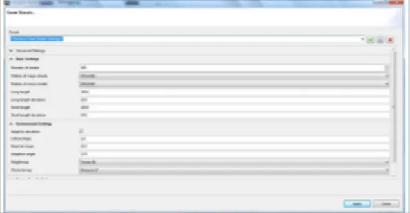
In this sense, the CityEngine, for example, presents modeling software 3D specialized in generation of models of urban environment. CityEngine has
been built in ETH Zurich, by Pascal Mueller, co-founder and CEO of the Inc Procedure. During his doctorate research in ETH Computer Vision Lab, Mueller invented a big quantity of innovative techniques of procedure modeling of content 3D for the architecture that has been compiled and nowadays results in the software CityEngine. (Figure 1)
The CityEngine has been acquired by ESRI, firm of the principal commercial GIS software on the world (ArcGis), and in function of this change the software has incorporated the logic of spatialization Geo-referenced of data, becoming a GIM.
Among the potentialities of the system, we can quote the possibility of:
• Introduction to the digital models of elevation in order the city acquires the relief representation and the insertion of maps of obstacles to inform where it wants the creation of streets and lots in the urban subdivision (Figure 2),
ISSN 1828-5961 Modeling urban landscape: New paradigms and challenges in territorial representation
• To inform size of lots blocks and widthsof streets (Figure 3),
• To define pattern of the urban road morphology (Figure 4)
• Construction of streets and lots according to parametrization of the user (Figure 5)
• Constructions of edifications according to parameters defined by rules (Figure 6)
In this sense, Cityengine becomes interesting to work toward Parametric Modeling of Territorial Occupation (PMTO).
Other consideration to favor the convergence between GIM and PMTO, are the new goals in the structuration of the cadastre and urban plants to feed the Geographic Information System and meet the new necessities of understanding the territory as a continuous and integrated system, and not more fragmented in primitive graphics that were cartographic generalizations of the reality. It is the concept of a “parcel”. Walking in this same direction, in Brazil, in 2009, the City
Ministry published the Ordinance n.511, which establishes guidelines for the implementation of Territorial Multifinalitary Cadaster, aiming to ensure the emphasis on the land regularization question, and recognizing the social function of properties. The first step is to elaborate a portrait of the territory. Second the 2º article of this ministerial ordinance, the parcel is the less unit of cadastre, defined as a contiguous terrestrial surface, and as a unique juridical ordinance. (BRASIL, 2009). (Figure 7.)
It is also worth mentioning the innovator role of the concept or “parcel” as a new referential element of the spacialization of the territorial
occupations. The municipal managers, at first, when placed before the new concept, get scared in front the complexity for its application. Mapping a territory as a mosaic where there are no gaps among its elements is not a simple task, and will require a paradigm change. Notwithstanding, this new paradigm is the perfect translation of the topology in the territory, because it is as we performed a matrix representation of the territory, in what all the cells receive, necessarily, an attribute. So is the territorial reality, and this new paradigm is a form to represent the reality how it is. (Moura, 2012).
The presence of that new territorial reference
Figure 2 - Digital Elevation Model, obstacles maps and created lot.
Figure 4 - ROAD URBAN MORPHOLOGY - CityEngine
ISSN 1828-5961 Modeling urban landscape: New paradigms and challenges in territorial representation
brings quality to topological representation. It will provide to GIMs a new territorial representation, resulting in better communication, visualization and topological quality of data, to make possible the parametric modeling of data, what means to elaborate interpretative pictures with properties and own characteristics of the real elements. The present work uses the software CityEngine to structure the goals of a GIM system, as a parameterized modeling of the territorial occupation. It is tested on the reality of Belo Horizonte, simulating the results of its Master Plan, for the evaluation of the landscape composition allowed according the urban normative. In this sense it will be possible to provide to the public administrators a system that guides the definition of areas with potential of transformation and the preferential areas for urban densification. METHODOLOGY
To develop this work, we follow the methodological steps:
1. Bibliographic review for the study
2. Tabulation of the urban parameters of Belo Horizonte
3. Development of the algorithm 4. Definition of simulation software 5. Definition of the pilot area 6. Pre-processing of the lots in arcgis
7. Entering data in cityengine 8. Creation of rules
9. Test the rules in the chosen area of study The methodological script of this study starts with the investigation of new values and concepts in the geoprocessing, lecture and reflection about the state of art from the normative of regulation of the transformation of the urban landscape, and choosing more adapted tools to the necessities of planning and management of the landscape, according to the specific interests in finding a support system to the planning that has a comprehension of the new concepts of GIM e PMTO.
The first step was to evaluate the applicative CityEngine, simulating parameters that are defined in the Brazilian urban normative. In this sense, for the building of rules, it was necessary to process information of the urban parameters of Belo Horizonte to verify which are the permissions and restrictions of each type of zoning.
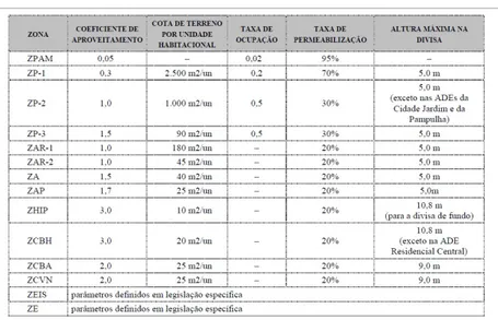
From the Master Plan of Belo Horizonte were extracted the coefficient information of use, quota of ground, occupation tax, maximum height and spacing on the border. (Figure 8). As the parameters that rule each zoning were verified, it was necessary to develop the logical rule to base the algorithm of parameterization
Figure 5 - Construction of streets by the user.
Figure 7 - Contiguity parcels
ISSN 1828-5961 Modeling urban landscape: New paradigms and challenges in territorial representation
to be insert in the system. It was defined that in this first moment the tests would consider the parameters of the coefficient of utilization, occupation tax, maximum height and spacing on the border. Those parameters had been chosen because they demonstrate bigger complexity in the input of the algorithm. This initial rule has been elaborated through the developed studies in the Laboratory of Geoprocessing of the School of Architecture and Urbanism of the Federal University of Minas Gerais, Brazil with the collaboration of Lucas Saliba. (Figure 9).
To understand what makes this first rule generated, comprehended as a base rule, it quotes an example: considering the area of a lot of 1000 m² being the extensions of 20 m in front and 50 of depth. Respected the frontal spacing (5 m), lateral (2,5 m) and of funds (2,5 m) the area that can receive occupation, removed only the spacing is of 637,5 m².
However, this area is reduced by the definition of occupation tax, because assuming that in this lot it is 0,5, it limitates the occupation in 500 m2. How 637,5 m² > (0,5*1000m²), then we must apply a factor of scale in the designs of the
possible polygon to receiving the edification. This scale factor is: 1000 m²*0,5 / 637,5 m² = 0,78. So, it will be necessary to do a reduction in the area liable of construction of 637,5 m²*0,78 = 497,25 m². Besides this, having as coefficient the use 0.5, the height of the edification will be 1000 m²*0,5/497,25 = 1 pavement. In case of the use coefficient be 1 (100%), the number of pavements is calculated like that in function of the projection area of edification: 1000 m²*1/497,25 = 2 pavements.
This rule will be applied to all zonings, changing only the variables of coefficient of utilization, occupation tax, spacing and maxim height in the border. It is important to register that in the zoning that do not possess information of the occupation tax, the utilized value is corresponding to the inverse value of the permeability tax, that means, if the permeability tax is 20% and the occupation tax is 0 in the table, we use the value of 0,8 for that last variable.
For the zonings that has the parameter of the maxim height in the border superior to five in the border superior than five, it was necessary to do
other algorithm. For this process it was:
1. Calculate the area of the lot and multiply by the use coefficient
CA*Area Lot = Total constructive added to the areas of all pavements (ATC)
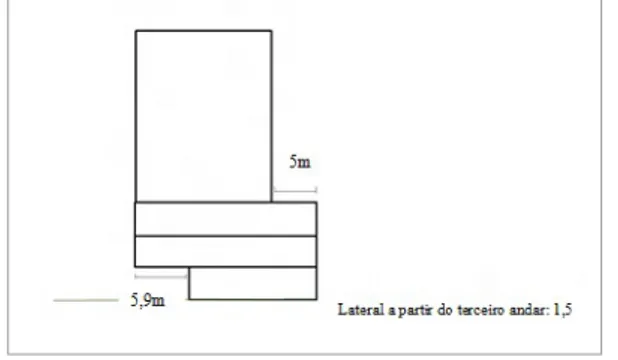
2. 1º pavement: Depart 5,9 m frontal and rise 3 m (value of height of each pavement) Calculate the area.(A1)
2 e 3º pavement: Rise 3 meters for each. Calculate area of both (A2)
Calculate the area of the three pavements: A1+A2+A2 = A3
3. The area of the total possible of construction added to the pavements less the area of the three first pavements will give the value of the possible building a = ATCp
It is necessary to do a new calculation of area
Figure 8 - Table of urban parameters
ISSN 1828-5961 Modeling urban landscape: New paradigms and challenges in territorial representation
considering the spacing that are necessary starting of the third pavement (1,5 lateral e 5 background) = A4
So ATCp/A4 = number of pavements that we can build.
The conformation of this edification, in the lateral view, corresponds to the illustration in the illustration that follows. (Figure 10).
It is defined that will be developed a rule by zoning, applying different textures for each one in order to symbolize them and, after, apply random factors in order that the landscape of the model resemble the witnessed reality. The textures are rules already done and available through the software to represent elements of facade and roof, as so the distribution and type of windows, coating material, roof material, among others. Eventually it would be possible to compose rules for new textures, but the present interest of the research is limited to use the applicative as a support to simulate the parameterization of the landscape, so it will apply rules and textures already done and available.
The zoning ZHIP e ZCBA; ZCBH e ZCVN were grouped following the rule of the maxim height of the border, once they have the same value in this item in the procedure.
In this first definition of rules and algorithms, the parameters of “quota of land by unity” and the “areas discountable” in the calculation of constructed area (elevator box, stairs, balconies, et alia) were not considerate.
Anyway, according to a brief research with two big offices of architecture in Belo Horizonte, it has been found that the average of discounts for the circulation areas vary between 25 e 35m² and the areas for balcony vary between 35 e 45m², and that the balconies are practically absent in commercial buildings and in low standard buildings, and in the edifications of entrepreneurship practically discounts are not realized. This parameter will affect the maxim height of buildings, because considering the area to be discounted the tendency is increase in the height of buildings.
In other way, the “quota of land for unit” (that controls the number of individual units that one lot can receive, according to its dimension), will be the parameter that will give a factor of reduction of the height of building, since it is the instrument that controls the level of volumetric densification in the lots. It works specifying how many square meters one lot must have for each unit.
This “quota of land for unit” and other parameters are being studied to understand how to insert them in parametric rules.
After the definition of the two first rules that will base the simulation of Belo Horizonte city, it was necessary to work the data of squares, lots and streets for the construction of a prototype for the test of the rules. In this phase of tests, it has been selected a theoretical area with twelve blocks with different zoning to validate the consistence of the rules. Those lots possess the real space conformation and have been selected in central area of Belo Horizonte. (Figure 11).
As the objective was to evaluate the CityEngine to the parameterized modeling of territorial occupation, the zoning in which those lots were inserted is fictitious. It is important to register that even the lots don’t match with the reality, because the goal was to test the application and the function of the rules according to different
zoning parameters.
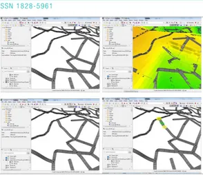
At the ArcGIS software, it has been developed the first stage in terms in the pre-processing of the information. It was necessary to manipulate the table of attributes of those twelve lots to insert the information of the zoning to each one, specifying the basic rule for each zoning and what is the “start rule”. Enter which is the “start rule” in the attribute table of the shapefile of lots allows the creation of rule files for each zoning with the respective values. When the lots are inserted in the cityengine, the reading of the parameters and values is made automatically. This work, developed in the GIS, automatized the recognition of the rules that are the base in the CityEngine. (Figure 12)
In order to succeed applying textures in the streets, it was necessary to create an archive correspondent to the access, pursuing the logic of representation of the parcels of the continuous
Figure 10. - Illustration of the buildings in the zoning whose maximal height parameter is 5m.
ISSN 1828-5961 Modeling urban landscape: New paradigms and challenges in territorial representation
territory (Figure 13). The blocs and lots must form a surface juxtaposed in order to be possible to work with the urban simulations. The CityEngine, that is an application of convergence of the BIM e GIS, works better when the cadaster is structured according the concept of parcels, as already discussed. For that is has been elaborated a tool inside ArcGIS for fill the empty space among the lots and the calculation of thicknesses.
After finishing preparing the data base of the streets, blocks and lots in GIS, started the work in the CityEngine. The first step was the elaboration of a scene for the pilot-area. The CityEngine works with a context of creation of a scene for storing the territorial information geo-referenced of the city. (Figure 14).
After that, the selected blocks to be tested were imported, with their parameters and the parameterization of the lots. (Figure 15).
All the zone parameters of Belo Horizonte have as starting point to the lateral, frontal and
background distances. To take this definition of which of the side of the lot is the front, it has been necessary to do this identification manually in the software. All this process is still manual, once the scripts for automatic definitions of these references still don’t work (Figure 16). When the automatic procedure has been used the software eliminated some important lots for analyses. Because of this, the procedure has been realized individually for each block. The reason of this care in specifying the principal front of the lot happens because the software recognizes initially only one front by lot, identified as the first two vertex of the polygon that conforms the lot, what restricts the representation of the corner lots that have two fronts and the parameters off set-back, for instance, must consider two frontal set-backs. Then it was time to initiate the elaboration of the rules (Figure 17). The rules delimitate the urban parameters according to each zones, and because of that it was a complex activity with big difficulty.
Figure 12 - Pre-processing of data in ArcGIS.
Figure 13 - Streets parcels
ISSN 1828-5961 Modeling urban landscape: New paradigms and challenges in territorial representation
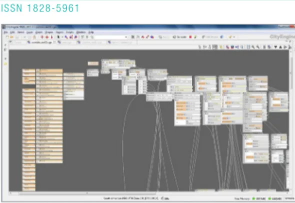
As initially it has not been identified other researchers or users questing these procedures in Brazil, the development of rules don’t count with the collaboration of a virtual community. There are researches working with virtual realities, but not so many with real problems brought by the real urban laws. The development is done in Pyton or in the adequate interface of the system. In this stage it has become clear that it could more agile to elaborate a rule for zoning, to become possible to lead with each case specifically. (Figure 18, Figure 19, Figure 20).
The algorithms implanted were the development of the first rule, but including distances, tax of occupation, and coefficient of occupation, exhibited in the beginning of the methodology, are: attr Frontal = 6 attr Lateral = 3 attr TO = 0.4 attr CA = 3 Lot --> Area(geometry.area) Area(area) --> Afast_F(area)
Afast_F(area) --> setback(Frontal) { streetSide : NIL | remainder : Afast_L(area) }
Afast_L(area) --> setback(Lateral) { noStreetSide : NIL | remainder : projecao(area) }
Figure 18 - Rules developed in Pyton and the system interface.
ISSN 1828-5961 Modeling urban landscape: New paradigms and challenges in territorial representation
projecao(area) --> case geometry.area > area * TO : Redimensiona(area, geometry.area)
else : Sobe(area, geometry.area)
Redimensiona(area, areaP) --> s(‘area*TO/ areaP, ‘area*TO/areaP, ‘1) center (xz) Sobe (area, geometry.area)
Sobe (area, areaSC ) --> extrude(3*(area*CA/ areaSC)) Shape
The reference of values that the applicative uses for specifying the height of the building is not given in number of pavements, but in meters. In order to be possible to really represent the reality in the visual proportion, it was necessary multiply the final value of numbers of pavements by 3, considering that each pavement has the average of 3 meters in height.
To the role of zoning that possesses maxim height in border superior to 5 meters, the basic rule was: attr Frontal = 5 attr Lateral = 1.5 attr FrontalR = -5 attr Background = 5.9 attr TO = 0.4 attr CA = 3 Lot --> Area(geometry.area) Area(areaT) --> Afast_F(areaT)
Afast_F(areaT) --> setback(Frontal) { streetSide : NIL | remainder : Bloco(areaT) }
Bloco (areaT) --> extrude (3) 2Andar(geometry. area)
2Andar (areaT, A1) --> Offset (FrontalR) Extrude (2*3) Edificio(areaT, A1, geometry.area)
Edificio(areaT, A1, A2) Offset (Lateral) | offset
(Fundo) Sobe (areaT, A1, A2, geometry.area) Sobe (areaT, A1, A2, A4) --> extrude(3*(((areaT-(A1+2*A2))/A4)) Predio
Those base rules contemplate the possibilities to the building as an envelope, which are entire blocks with no texture. After developing those algorithms, it suits the stage of testing to develop the textures. After the composition of all the rules, the sequent step was modeling the city with various typologies of zoning mixed, to verify the landscape composition of the entire city. For those initial rules it was choose to considerate all the potential constructive of each lot in its respective zoning. That because the first model intends to illustrate how could be the image of the city if all the lots proprietaries decided to build all that is permitted. That would be a way to
Figure 19 - Parametric rules in CityEngine
ISSN 1828-5961 Modeling urban landscape: New paradigms and challenges in territorial representation
simulate the results of the proposals of a Master Plan. (Figure 21, Figure 22, Figure 23).
After created ad tested all the rules, the next step will be the improvement of the representation of some parameters and the inclusion of others not considered yet, as the quota of the land and the area discounts; the rules to the streets; to improve some textures and, finally, modeling the city of Belo Horizonte according real data. Anyway, the result obtained indicates to be already possible to discuss the GIM with the parametric modeling of the territorial occupation. The creation of an interpretative portrait of the city, according to the permissions of urban normative shows that the GIM/PMTO can be tools of large value in decision making in urban p
DISCUSSION
We are facing new paradigms in territorial representation, especially in urban planning. This study indicates that we are in the correct way to the elaboration of one system to support planning that will improve visualization to urban propositions, with the goal to make possible a more effective and participative city plan. The simulation of the city landscape results will allow evaluating if the urban expansion is according to the logics of maintaining the social function of the city.
This study is part of the proposal of the doctorate thesis denominated “Geoprocessing in the Parameterized Modeling of Territorial Occupation: applications in the simulation of onerous grant of the building right” in development by Sheyla Aguilar de Santana under the orientation of Dra.
Figure 21 – Modelled City - Perspective 1
Figure 22 – Modelled City - Perspective 2
ISSN 1828-5961 Modeling urban landscape: New paradigms and challenges in territorial representation
Ana Clara Mourão Moura, in the Post-Graduate Program, School of Architecture and Urbanism, Federal University of Minas Gerais, Brazil. The next steps are the construction of the model of the city of Belo Horizonte according to the urban normative, the elaboration of the model of the city of Belo Horizonte according to its real state, the comparison between both for identification of areas with constructive stocks and possibilities of landscape renovation in order to help in the definitions of the probable area of urban densification and receiving of coefficients resultants of the urban regulations existing in the country.
It is important to register that, as it is a very innovative work, there has been many difficulties in the definition of the logic of the rules. And so with the compilation of those information in parametric base to be understood by the software, because modeling games and virtual reality is very different to modeling reality and its complexity. The results shown illustrate a large evolution in the modeling of scenarios, since there is nothing similar yet been developed in Brazil.
BIBLIOGRAFIA
BENACH, Nuria y TELLO, Rosa (2000). “En los interstícios de la renovación. Estartegias de transfor-mación del espacio y flujos de po-blación en Barcelona”, in Revista de Geografia, Barcelona, no prelo, 27p BRASIL – Ministério do Planejamen-to. Decreto 6.666 de 27/11/2008, que institui na esfera do Poder Ex-ecutivo federal a Infraestrutura Na-cional de Dados Espaciais – INDE. BRASIL. Portaria Ministerial no. 511, Ministério das Cidades. 07 de dez. de 2009. Institui Diretrizes para a Criação, Instituição e Atualização do Cadastro Territorial Multifinalitário (CTM) nos Municípios Brasileiros. Giacomelli, Andrea (2006) Integra-tion of GIS and SimulaIntegra-tion Models, p.181 - 192 In: Campagna, M. GIS for sustainable development. CRC Press- ISBN 0-8493-3051-3 (alk. paper), 535p.
HARVEY, David (1996) “Do gerencia-mento ao empresariagerencia-mento: a trans formação da administração urbana no capitalismo tardio”, in Espaço & Debates, Número 39, NERU, p. 48-64.
LEFEBVRE, Henry (1999). A Rev-olução Urbana (S. Martins, Trans.).
Belo Horizonte: Editora da UFMG Moura, Ana Clara M. (2012). Learn-ing topics in urban plannLearn-ing at UFMG: geoprocessing to support analysis, planning and proposal of the urban landscape at neighbor-hood scale. 5th International Semi-nar on Environmental Planning and Management - Urban Responses for Climate Change - Brasilia, Brazil - October 18 – 20, 2012. 15 p. MOURA, Ana Clara M., MOURA, Carlos Alberto, SANTANA, Sheyla Aguilar, LANNA, Lucas S., AZEVEDO, Úrsula Caroline, LOURENÇO, Paula M. (2010). Geoprocessamento nos diagnósticos e prognósticos de áreas de interesse especial ao na área de influência das linhas de transmissão da CEMIG - estudo de caso da RMBH. Anais do XXIV Con-gresso Brasileiro de Cartografia , Aracaju-SE.
NICCOLA, C. (1991) Dialettica di modelli e fattori d´incertezza nelo studio dele aree metropolitane. In.: Bolognafiere – SAIE. Il projeto met-ropolitano: la città Europea, Bolo-gna: Fiere di Bologna. p. 20. SOUSA SANTOS, Boaventura (2000) Pela mão de Alice: o social e o político na pós-modernidade. São Paulo: Cortez.
Campagna, Michele. (2012). Lecture Notes: Planning Support Systems: Models and Design principles. Spatial Data Infrastructures and Volunteering Geographic Informa-tion: advanced development on data sources for GeoDesign. NP-GAU – Núcleo de Pós-Graduação em Arquitetura e Urbanismo, UFMG, ARQ 808.