UNIVERSITA’ DEGLI STUDI DELLA TUSCIA
FACOLTA’ DI AGRARIA
DIPARTIMENTO DI TECNOLOGIE, INGEGNERIA E SCIENZE
DELL’AMBIENTE E DELLE FORESTE
H
YDROLOGICAL MODELS FOR WATERSHED PLANNING AND WATER RESOURCES MANAGEMENT:
A
D
ECISIONS
YSTEMS
UPPORT FORM
ARTAR
IVER BASIN(
CENTRAL ITALY)
Dottorando:
Federica Gobattoni
Coordinatore:
Prof. Gianulca Piovesan
Tutor:
Prof. Antonio Leone
ABSTRACT
Fresh water is a finite and vulnerable resource, essential to sustain life and with a great economic value in all its competing uses and interactions with natural ecosystems as they strictly depend on water above all. Population and economies under rising growing lead to an increase in water demand while its availability remains constant in time. So that drought is actually an insidious hazard of nature for countries experiencing medium to high water stress due to its scarcity and to changed climate conditions showing a decreased amount of precipitation and higher temperature values. Drought is a severe problem in the Mediterranean basin: international conventions and Institutions such as the World Bank and the International Water Forum all consider the area in need of special attention due to problems resulting from its vulnerability to drought and its requirements for better water management. Moreover the European Community policy is directly involved in water scarcity issues, encouraging project development and actions to mitigate the effects of drought and to investigate measures to avoid or reduce drought risk in Mediterranean regions.
The project MEDDMAN is a transnational approach in the field of drought and water management involving competent national authorities, leading research institutes and regional authorities and financed by European Union according to its Interreg III B MEDOCC policy. The DAF Department, Department of Environment and Forestry, Agrarian Faculty, University of Tuscia in Viterbo, has been involved in this project with a study area on Marta River Basin, located in the northern part of Latium region. The project's target is to develop an integrated system, capable of evaluating the state of surface water and groundwater resources in the MEDOCC regions preserving and improving the economic growth, developing efficient tools for sustainable water resources exploitation. Special attention is given to the environmental impacts of extreme meteorological and hydrological events, which affect the means of development and best interest of the locals. The focus is on the understanding of the ‘water system’ dynamics and functioning, enhancing the capability to predict its behavior in view of changes (including climate change), and underpinning its sustainable management and development. A simulation model at catchment scale, has been implemented for Marta river basin using SWAT (Soil Water Assessment Tool) code, developed in 90’s by Dr. Jeff Arnold for USDA-ARS, United States Department of Agriculture, Agricultural Research Service. Swat is a comprehensive model that requires a diversity of information and produce reliable results with a rich dataset at disposal (morphological, soil, climatic, hydrologic data). It enables water balance estimation and models the loading of water, sediments and nutrients from land areas in a watershed or to the stream network from sources not associated with a land area and referred to as point sources, such as treatment plants.
The simulation period covers the years 2006. The model was calibrated for the period 1999-2002 and then validated for the period 2003-2006. The implemented model shows a substantial reliability and accuracy in providing the watershed response in terms of discharge flowing and timing pointing out a rapid rebound on it as a consequence of heavy rainfall events. Statistical tests confirmed the truthfulness of its results.
A good correspondence between observed and simulated values can be obtained also regarding nutrients movement and processes even if the available data were not so complete and comparable in terms of nitrogen and phosphorous, and their compounds, concentrations.
Surely, the nitrate concentrations found in the monitoring campaigns carried out by the Regional Agency for Environmental Protection (ARPA Lazio) are quite well represented by model results. Such a hydrological and nutrient transport simulation model, can be certainly a powerful and reliable tool for water and natural resources planning in order to achieve a rational and prudent management of them taking into account anthropic needs (water demand, agricultural activities, wastewater treatment plants, hydroelectric power production and so on) but also ecosystems preservation (ichthyic life requirements, river Minimum Flow Requirement, biological communities and so on) and economic aspects allowing to evaluate and compare benefits, disadvantages and consequences for each suggested or hypothesized technical solution on watershed.
For the particular characteristics and past of Marta basin, the implemented SWAT model can provides an overview of its multifaceted response to climatic and human pressures and also an estimation of the future available water resources quantity and quality.
To have a general overview of the whole basin hydrologic behavior, a seawater wedge simulation model has been implemented for the coastal alluvial aquifer of Maremma Laziale applying Sharp_sar code (Santini, 2008) modified version of SHARP (Essaid, 1990).
When the width of the transition zone is small relative to the thickness of the aquifer, saltwater and freshwater can be assumed as immiscible fluids separated by a sharp interface and this approach reproduces the general position, shape and behavior of the interface. SHARP model couples the freshwater and saltwater domains through the interfacial boundary condition of continuity for flux and pressure.
With a simulation period of 10 years, Sharp_sar model was implemented on Maremma Laziale coastal aquifer and the results show that after of a pumping period of 10 years, saltwater intrusion might occur in the area between Fiora river and Arrone stream.
The initial condition was set using the Badon-Ghyben (1889) e Herzberg (1901) laws to place the initial interface between fresh and salt water so that to ensure the model results after 10 years of simulation.
The interface appears located along the coastline without showing clear signs of intrusive phenomena taking place in the middle and southern part of the coastal aquifer, while a retreat of the fresh water is clear in the northern part of it up to 1.2 km inland, in the area between Fiora river and Arrone stream and then confirming what emerged from the study for the establishment of coastal environmental state “(Chiocchini et al., 2005).
Even with several uncertainties on number of existing wells, since it’s not mandatory to declare a private well, on pumping amounts and periods the model results point out a supposed critical area with a particular vulnerability to saltwater intrusion phenomena.
Other smallest areas in southern part of the coastal aquifer seem to be interested by saltwater intrusion phenomena falling in Tarquinia municipality.
Coupling a SWAT model for hydrologic and nutrients transport simulation and investigation with a saltwater interface simulation model, such as SHARP_sar, for the coastal area of this basin, give the opportunity to take into account the several and different aspects and issues connected with the whole watershed behavior and evolution. A correct planning and management of the available natural resources involve a conscientious water bodies exploitation, with respect to habitats and local animal and plants requirements, avoiding saltwater intrusion phenomena and environmental damage, accomplishing people needs, economic, agricultural and tourist development and income, but, above all, ensuring citizens and buildings safety. In the local and actual context, regarding past and present events in the study area, an incisive and suddenly action from government is hoped in order to restore equilibrium conditions and environmental health for watershed. Going on in making information and investigation results available to all the stakeholders and people involved, directly or indirectly, in Marta river basin management, could allow an increase in awareness and consciousness and lead to quickening planning actions and works in a shared and advantageous way for all. Especially with regards to Minimum Flow Requirement, in relation with the water amount deviated for hydroelectric power generation, a rational regulation of the sluice-gates located on Marta river at the exit of lake Bolsena, is needed to ensure ichthyic life and ecosystem preservation together with simple turbines volumes required to correctly working.
A multifaceted and integrated approach could certainly be applied in such a complex problem- solving, with the help of hydrologic and nutrients transport simulation models, saltwater intrusion position and movement simulation models and building all the data and results in a GIS platform as to provide a real and concrete Decision System Support.
Key words: hydrologic model, SWAT, watershed simulation, water balance, Minimum Flow
_________________________________________________________________________Contents
CONTENTS
INTRODUCTION ……….….1
CHAPTER 1……….3
INTEGRATED NATURAL AND WATER RESOURCES MANAGEMENT………..3
1.1 SUSTAINABLE DEVELOPMENT AND NATURAL RESOURCES MANAGEMENT……..3
1.2 DESERTIFICATION AND DROUGHT HAZARD………4
1.3 SHORTENING OF COASTLINE: NATURAL AND HUMAN INDUCED PHENOMENA…5 1.4 DROUGHT IN THE MEDITERRANEAN REGION………...6
1.5 MEDDMAN PROJECT……….9
1.6 RESEARCH PURPOSES AND APPLIED METHODOLOGIES………..10
CHAPTER 2………...14
HYDROLOGIC MODELING AND PLANNING………14
2.1 A BRIEF LOOK BACK………...16
2.2 BASIC MODELING APPROACHES……….18
2.3 PARAMETER ESTIMATION………19
2.4 PARAMETER ESTIMATION CRITERIA……….20
2.4.1 PERSONAL PARAMETER ESTIMATION………21
2.4.2 LEAST SQUARES………...21
2.4.3 ABSOLUTE ERRORS………..21
2.4.4 METHOD OF MOMENTS………...21
2.4.5 MAXIMUM LIKELIHOOD……….21
2.4.6 ARBITRARY OBJECTIVE FUNCTIONS………..22
2.4.7 BAYESIAN ESTIMATION……….22
2.4.8 CONSIDERATIONS………22
2.5 EVENT MODELING………..23
2.6 CONTINUOUS SIMULATION MODELS……….25
2.7 INFORMATION SYSTEM TECHNOLOGIES-GEOGRAPHICAL INFORMATION SYSTEM………28
2.8 INTEGRATION OF GIS AND HYDROLOGIC MODELS-DSS………..31
2.17 ROLE OF HYDROLOGIC MODELS IN WATER RESOURCES MANAGEMENT AND LAND USE PLANNING………..34
2.10 WATER RESOURCE PLANNING IN THE HISTORY………..36
2.11 RIVER BASIN PLAN EVOLUTION IN ITALY AND EUROPE………..40
_________________________________________________________________________Contents
2.11.2 THE 2000/60 EUROPEAN UNION DIRECTIVES………...42
CHAPTER 3………...44
SWAT MODEL………..44
3.1 GENERAL DESCRIPTION OF SWAT MODEL………..44
3.3 OVERVIEW OF SWAT MODEL………...47
3.4 LAND PHASE OF THE HYDROLOGIC CYCLE……….48
3.4.1 CLIMATE……….49 3.4.2 HYDROLOGY………..51 3.4.3 CANOPY STORAGE………...51 3.4.4 INFILTRATION………...52 3.4.5 REDISTRIBUTION………..52 3.4.6 EVAPOTRANSPIRATION………..54
3.4.7 LATERAL SUBSURFACE FLOW………..55
3.4.8 SURFACE RUNOFF- CURVE NUMBER METHOD (SCS-CN)………..56
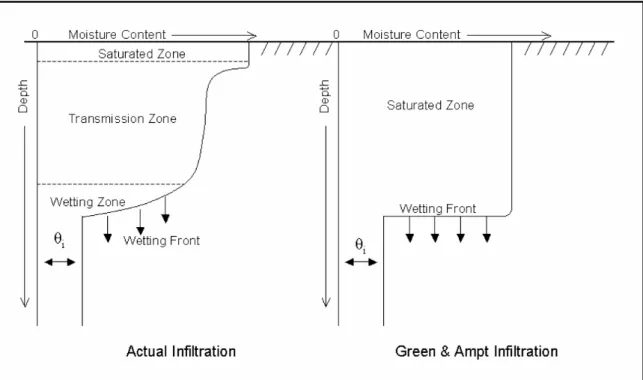
3.4.9 GREEN & AMPT INFILTRATION METHOD………...60
3.5 ROUTING PHASE OF THE HYDROLOGIC CYCLE………..63
3.5.1 LAND COVER/PLANT GROWTH………65
3.5.2 HEAT UNITS………66
3.5.3 POTENTIAL GROWTH………...67
3.5.4 EROSION………..67
3.6 MUSLE……….68
3.7 COVER AND MANAGEMENT FACTOR………69
3.8 NITROGEN CYCLE………70
3.9 PHOSPHOROUS CYCLE………...73
3.10 PESTICIDES………..75
3.11 MANAGEMENT PRACTICE………...75
3.12 PLANTING/BEGINNING OF THE GROWING SEASON……….75
3.13 HARVEST OPERATION………..76
3.14 GRAZING OPERATION………..76
3.15 HARVEST AND KILL OPERATION ……….77
3.16 KILL/END OF GROWING SEASON………..77
3.17 TILLAGE………...77
3.18 FERTILIZER APPLICATION………..77
_________________________________________________________________________Contents
CONTENTS
3.20 IRRIGATION……….78
CHAPTER 4………...80
STUDY AREA: MARTA RIVER BASIN DESCRIPTION AND INVESTIGATION………80
4.1 STUDY AREA GENERAL DESCRIPTION………..80
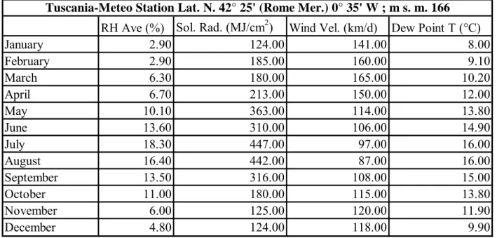
4.2 CLIMATIC CHARACTERIZATION……….85
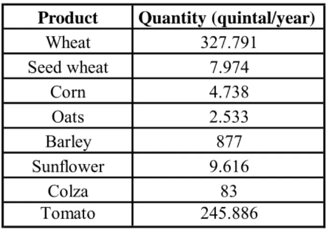
4.3 LAND USE………..91
4.3 HYDROGRAPHY………...95
4.3.1 WATER DRAWINGS………..96
4.4 WATER QUALITY AND MONITORING……….99
4.5 FLOW ANALYSIS………106
4.5.1 FLOW REGIME ANALYSIS……….106
4.5.2 FLOW DURATION CURVE……….110
4.5.3 FLUVIAL HYDROGRAPH ANALYSIS………..111
FIG. N°4.14 RECESSION LIMB OF THE HYDROGRAPH FOR TARQUINIA MEASURES………114
4.5.4 FLASHINESS INDEX ESTIMATION………..114
4.6 MINIMUM FLOW REQUIREMENTS DEFINITIONS AND METHODS……….116
4.6.1 MATTHEY’S FORMULA……….118
4.6.2 MONTANA METHOD………..118
4.6.3 METHOD………...119
4.6.4 FLOW DURATION METHOD………..121
4.6.5 BAXTER METHOD………...121
4.6.6 METHODS WITH A BIOLOGICAL RESPONSE………122
4.6.7 HQI (HABITAT QUALITY INDEX)……….123
4.6.8 MICRO-HABITAT METHODOLOGIES………..124
4.6.9 INSTREAM FLOW INCREMENTAL METHOD (IFIM)………...124
4.6.8 WETTED PERIMETER TECHNIQUE………..127
4.6.9 PHYSICAL HABITAT SIMULATION SYSTEM (PHABSIM)………...128
4.7 MINIMUM FLOW REQUIREMENT ESTIMATES FOR MARTA RIVER………...129
4.8 SALTWATER INTRUSION THREAT……….134
4.8.1 MAREMMA LAZIALE AQUIFER STRUCTURE………...134
_________________________________________________________________________Contents
A SWAT MODEL FOR MARTA RIVER BASIN……….139
5.1 INPUT DATA COLLECTION AND ELABORATION………...139
5.1.2 SOIL DATA………139
5.1.3 CLIMATIC PARAMETERS……….143
5.3 CALIBRATION AND VALIDATION……….149
5.4 RESULTS………...152
5.4.1 WATER BALANCE………...153
5.5 MINIMUM FLOW REQUIREMENT- ESTIMATED VS SIMULATED VALUES………...158
5.6 WHAT IF SCENARIO SIMULATION………160
CHAPTER 6……….162
SALTWATER INTRUSION MODELING IN THE STUDY AREA……….162
6.1 SALTWATER INTRUSION-HISTORICAL DEVELOPMENT………..162
6.2 CONCEPTUAL AND MATHEMATICAL MODELS……….164
6.3 DISPERSE INTERFACE APPROACH ………...167
6.4 SHARP INTERFACE APPROACH……….168
6.5 CONSIDERATIONS ABOUT DIFFERENT APPROACHES……….169
6.6 SALTWATER FLOW MODEL SHARP………..170
6.7 LEAKAGE TERMS………...173
6.8 NUMERICAL FORM OF THE FRESHWATER AND SALTWATER FLOW EQUATIONS………...174
6.9 SOURCES AND SINKS………175
6.10 MODIFIED VERSION OF SHARP MODEL-SHARP_SAR……….176
6.11 SHARP-SAR MODEL IMPLEMENTATION FOR MAREMMA LAZIALE AQUIFER……….177
6.12 SHARP_SAR MODEL RESULTS………..184
CHAPTER 7……….187
CONCLUSIONS AND DISCUSSION………187
______________________________________________________________________Introduction
INTRODUCTION
Water is a vital resource for human survival, health and dignity and a fundamental resource for human development but the world’s freshwater resources are under rising pressure since populations and economies growing lead to an increase in water demand while the availability of the resource remains constant.
Fresh water is a finite and vulnerable resource, essential to sustain life and has an economic value in all its competing uses and should be recognized as an economic good. Some numbers about water: the global water on the earth is made of about 97% seawater, 3% freshwater. Of the freshwater 87% not accessible, 13% accessible (0.3% of total) (Bear, 1999). Today more than 2 billion people are affected by water shortages in over 40 countries and 263 river basins are shared by two or more nations; 2 million tones per day of human waste are deposited in water courses. Half the population of the developing world are exposed to polluted sources of water that increase disease incidence. The increase in numbers of people from 6 billion to 9 billion will be the main driver of water resources management for the next 50 years.
Growth in population, increased economic activity and improved standards of living lead to increased competition for and conflicts over the limited freshwater resource. A combination of social inequity and economic marginalization forces people living in extreme poverty to overexploit soil and forestry resources, with damaging impacts on water resources.
Water research has been a major component of EU research since the late 1980s, covering a wide spectrum of water-related topics and evolving over the years in close correlation to EU water policy. Early Framework Programs mainly focused on enhancing scientific knowledge to support environmental quality standards and objectives and developing technologies for end-of-pipe treatment. They were mostly implemented through relatively small- and medium-sized projects that were then clustered to enable for integration and synthesis of results but also through large-scale integrated projects and networks of excellence that could accommodate integrated and holistic approaches and better embrace the critical mass and multi-disciplinarity needed to address the complexity of the system.
The project MEDDMAN is a transnational approach in the field of drought and water management involving competent national authorities, leading research institutes and regional authorities and financed by European Union according to its Interreg III B MEDOCC policy. The DAF Department, Department of Environment and Forestry, Agrarian Faculty, University of Tuscia in Viterbo, has been involved in this project with a study area on Marta River Basin, located in the northern part of Latium region.
______________________________________________________________________Introduction
The project's target is to develop an integrated system, capable of evaluating the state of surface water and groundwater resources in the MEDOCC regions preserving and improving the economic growth, developing efficient tools for sustainable water resources exploitation. Special attention is given to the environmental impacts of extreme meteorological and hydrological events, which affect the means of development and best interest of the locals. The focus is on the understanding of the ‘water system’ dynamics and functioning, enhancing the capability to predict its behavior in view of changes (including climate change), and underpinning its sustainable management and development.
__________________________Chapter 1-Integrated Natural And Water Resources Manangement
CHAPTER 1
INTEGRATED NATURAL AND WATER RESOURCES MANAGEMENT
1.1 Sustainable development and natural resources management
Sustainable development has been defined in many ways, but the most frequently quoted definition is from Our Common Future, also known as the Brundtland Report (1987):
"Sustainable development is development that meets the needs of the present without compromising
the ability of future generations to meet their own needs. It contains within it two key concepts: the concept of needs, in particular the essential needs of the world's poor, to which overriding priority should be given; and the idea of limitations imposed by the state of technology and social organization on the environment's ability to meet present and future needs."
All definitions of sustainable development require the vision of the world as a system connecting space and time.
Sustainable development focuses on improving the quality of life for all of the Earth's citizens without increasing the use of natural resources beyond the capacity of the environment to supply them indefinitely. It requires an understanding that inaction has consequences and that we must find innovative ways to change institutional structures and influence individual behavior. It is about taking action, changing policy and practice at all levels, from the individual to the international. Sustainable development is not a new idea. Many cultures over the course of human history have recognized the need for harmony between the environment, society and economy. What is new is an articulation of these ideas in the context of a global industrial and information society.
Progress on developing the concepts of sustainable development has been rapid since the 1980s. In 1992 leaders at the Earth Summit built upon the framework of Brundtland Report to create agreements and conventions on critical issues such as climate change, desertification and deforestation. They also drafted a broad action strategy—Agenda 21—as the work plan for environment and development issues for the coming decades.
In 1987 the World Commission on Environment and Development recommended seven critical actions needed to ensure a good quality of life for people around the world: revive growth, change the quality of growth, meet essential needs and aspirations for jobs, food, energy, water and sanitation, ensure a sustainable level of population, conserve and enhance the resource base, reorient technology and manage risk, include and combine environment and economics considerations in decision-making.
__________________________Chapter 1-Integrated Natural And Water Resources Manangement
These recommendations are as valid today as they were when first written. They are a call to change our actions and to do things differently.
Throughout the rest of the 1990s, regional and sectoral sustainability plans have been developed. A wide variety of groups—ranging from businesses to municipal governments to international organizations such as the World Bank—have adopted the concept and given it their own particular interpretations. These initiatives have increased our understanding of what sustainable development means within many different contexts. Unfortunately, as the Earth Summit +5 review process demonstrated in 1997, progress on implementing sustainable development plans has been slow. Around the world signs of severe stress on our interlocked global economic, environmental and social systems continuously appear. As the United Nations Environmental Programme's GEO-2000 report points out, the "time for a rational, well-planned transition to a sustainable system is running out fast" since full-scale emergencies through freshwater shortages, tropical forest destruction, species extinction, urban air pollution, and climate change are urgently to be faced.
1.2 Desertification and drought hazard
Water withdrawals have increased more than twice as fast as population growth and currently one third of the world's population live in countries that experience medium to high water stress and pollution is further enhancing water scarcity by reducing water usability downstream.
This situation can also engender water use conflicts, both in terms of quantity and quality and
drought is an insidious hazard of nature.
Together with the increase of water demand according to population growth and development needs, the effects of permanent features of climate in some regions of the world or the consequences of somewhat climate changes in others, make drought a reality in several countries and expose countries and people to drought risk.
Although the numerous definitions, drought originates from a deficiency of precipitation over an extended period of time, usually a season or more. This deficiency results in a water shortage for some activity, group, or environmental sector. Drought is relative to some long-term average condition of balance between precipitation and evapotranspiration (i.e., evaporation + transpiration) in a particular area, a condition often perceived as “normal”. It is also related to the timing (i.e., principal season of occurrence, delays in the start of the rainy season, occurrence of rains in relation to principal crop growth stages) and the effectiveness (i.e., rainfall intensity, number of rainfall events) of the rains. Other climatic factors such as high temperature, high wind, and low relative humidity are often associated with it in many regions of the world and can significantly aggravate its severity.
__________________________Chapter 1-Integrated Natural And Water Resources Manangement
Drought should not be viewed as merely a physical phenomenon or natural event. Its impacts on society result from the interplay between a natural event (less precipitation than expected resulting from natural climatic variability) and the demand people place on water supply. Human beings often exacerbate the impact of drought. Recent droughts in both developing and developed countries and the resulting economic and environmental impacts and personal hardships have underscored the vulnerability of all societies to this “natural” hazard.
Fig. n°1.1 Typology of water stress conditions (Vlachos, 1982)
1.3 Shortening of coastline: natural and human induced phenomena
The effects and consequences of drought may also be seen and felt in coastal areas due to freshwater scarcity and/or degradation including saltwater intrusion phenomena. As Kay and Alder (1999) suggested, within 30 years coastal areas may be occupied by more people than there are now living on the entire planet, reaching 6 billions people. This great population growth means a great water demand increase as well, and it may lead to critical and conflicting situation between nature and ecosystems on one side and human needs and economic development on the other. Freshwater scarcity should be direct consequence of increased unregulated pumping extraction, water courses deviations and man made cutoffs along rivers in coastal areas to satisfy domestic and irrigation requirements but the mentioned above pumping extraction of freshwater may also cause saltwater intrusion phenomena with further deterioration of natural systems. Wharfs and infrastructures at
__________________________Chapter 1-Integrated Natural And Water Resources Manangement
seaside, strongly alter coastal landscape and evolution processes stressing erosion and coastline shortening. Studies about coastline evolution in southern Italy, showed that a retreat of more than 250 m took place between 1938 and 1997 for the area of Gela in Sicily region (Pelorosso and Colantoni, 2008). Changes in coastal structures are quite complex since they are involved in short-term and long-short-term natural processes too. Together with anthropic pressures and impacts, long terms variations, such as tidal variations (Fuhrboter, 1989) effects on estuaries and coasts (Jonge, 1983) or the North Atlantic Oscillations (Garrad and Colebrook, 1978; Selten et al., 1999) influence on the North Sea and its fringes, may lead to shortening of coastline. Changes in meteorological conditions may reduce flow discharges in rivers and induce varying wind and temperature climate which can be responsible of significant coastline shortening as well. With the help of high resolution satellite imagines and monitoring network along the coastline, the Italian National Agency for Environmental Protection carried out studies and investigations on erosion effects on the coasts obtaining that about 63 km of coastline were loss in Italy during the last 50 years (APAT, 2006).
Shortening of coastline due to natural and human induced processes, may heavily impact on freshwater quantity and quality, with particular reference to saltwater wedge advancing that reduce groundwater availability and to river flow regime variations that threaten Minimum Flow Requirement respect. All these phenomena have to be seen as different aspects of drought, since they are linked together in cause-effect mechanism resulting in deficiency of water supply.
1.4 Drought in the Mediterranean region
Drought is a severe problem in the Mediterranean basin. International conventions and Institutions such as the World Bank and the International Water Forum all consider the area in need of special attention due to problems resulting from its vulnerability to drought and its requirements for better water management.
Drought has been defined as a natural cycle of stress and renewal inherent to those regions (Breman and Wit, 1983; Niemeijer and Mazzucato, 2002; Rasmissen et al., 2001; Tiffen and Mortimor, 2002) but increasing agricultural pressure on the land aggravates its consequences (Akhatar-Schuster et al., 2000). Drought depletes vegetative cover and may lead to human actions (suc as overgrazing) that propel dry lands rapidly towards a desert-like condition.
A major new threat is climatic change (Hillel and Rosenzweig, 2002).
Predictions on the future climatic conditions have been developed to investigate the effects of climatic changes on future availability of water and drought risk and forecasted consequences have been estimated to incisively face natural resources rational use and management issues.
__________________________Chapter 1-Integrated Natural And Water Resources Manangement
Modeling results suggest that dry areas could become hotter and drier, especially semiarid Africa and South Asia (Parry, 2002).
Scenarios covering the entire Mediterranean Region suggest up to 35% rainfall reduction by 2071-2100 reducing inland water flows and water yields (www.emwis.net/topics/WaterScarcity).
The IPCC (Intergovernmental Panel on Climate Change) projects under an A1 scenario (rapid and successful economic development, in which regional average income per capita converge - current distinctions between "poor" and "rich" countries eventually dissolve) a 4 to 27% average decrease in precipitations for the south eastern Mediterranean with significant spatial and seasonal variation. A 46% increase in “significantly drier than normal” years is expected for Mediterranean region with an exponential increase in drought probability and across the region drought is expected to reduce water availability severely, in some countries up to 60% in the coming century (Mediterranean Water Scarcity and Drought Report, Mediterranean Water Scarcity and Drought Working Group, 2006). If climatic change increases the frequency and7or intensity of droughts, it would aggravate desertification.
But all models have a “certain” uncertainty so that other outcomes are also possible: recent observations suggest that Sahel is re-greening (UNEP 2003). Although the reasons are not still understood, it’s clear that more factors than just rainfall and temperature, are involved.
The cause of water shortage may, in fact, depend not only on drought events or changed climatic conditions but more often on man-made actions like water contamination, inadequate planning or equipment, by an incorrect water resources management with huge consequences on the whole natural available resources.
Many possible solutions are being studied to improve the use of water in agriculture, which is the most important economic activity in these countries, encouraging a rational use of groundwater resources in times of drought, or invoking the construction of surface water reservoirs and economical solutions.
The European Community policy is directly involved in water scarcity issues, encouraging project development and actions to mitigate the effects of drought and to investigate measures to avoid or reduce drought risk in Mediterranean regions.
In 2006 and early 2007 the European Commission carried out an in-depth assessment of water scarcity and droughts in the European Union. Following this assessment the Commission presented an initial set of policy options to increase water efficiency and water savings in a Communication published in July 2007.
Water scarcity and drought was identified as one of the most important theme for the Mediterranean-UE Water Initiative/ Water Framework Directive Joint Process launched in 2004. A
__________________________Chapter 1-Integrated Natural And Water Resources Manangement
first draft report was produced in 2006 on the assessment of water scarcity and drought in the Mediterranean regions and then it was decided to continue the activities of the water Scarcity and Drought Working Group for a second period, 2007-2009.
Fig. n° 1.2 Sensitivity to desertification index (SDI) in the northern Mediterranean basin ( DISMED project, Desertification Information System for the Mediterranean, and EEA, 2005)
Several initiatives have been proposed by the European Commission to face drought and several projects have been financed throughout the European territories to encourage a rational and integrated natural resources management.
There is considerable variation across countries in laws and institutions related to water, and planning and project implementation ability is not uniform. Therefore The European Commission asks for cooperation between different regions and for the redaction of guidelines flexible enough and tailored to the different situations involving institutions, legal instruments, and the technical means to achieve an integrated approach to planning that considers all sources and uses of water in a given basin and all the available natural resources.
The community initiative INTERREG III is one of the Community Regional Policy tools oriented to the definition of common solutions to specific problems. The funds are mainly destined to favor a harmonious, balanced and sustainable development of the European territory recommending the
__________________________Chapter 1-Integrated Natural And Water Resources Manangement
constitutions of partnerships of beyond national borders to allow a balanced set up of multi regional territories.
Among Interreg III B projects, MEDDMAN (Gestion intégrée des ressources en eau, développeMEnt et confrontation Des méthoDologies comMunes et trAnsnatioNales pour la lutte contre la sécheresse aux régions MEDOCC) is a transnational approach just in the field of drought and water management with the aim to involve competent national authorities, leading research institutes and regional authorities. The project's target was to develop an integrated system, capable of evaluating the state of surface water and groundwater resources in the MEDOCC regions.
1.5 MEDDMAN Project
As the primary activity of the European Commission is now to encourage a comprehensive approach to water resources management activities, the integrated management of other resources in the watershed, such as soil and vegetation, has to be included in every action plan turned to water scarcity mitigation or water management plan.
The MEDDMAN project aims to develop an integrated system capable of assessing the state of surface water and groundwater resources in areas MEDOCC. In orde to preserve and improve economic growth, emphasis has been placed on the development of effective tools for sustainable water resources. Special attention has been made on the environmental effects of extreme weather events and water, affecting the livelihoods and citizens interests.
The improvement of the monitoring network was a target to be accomplished by choosing a suitable sensor system to perform a complete monitoring of meteorological, hydrological and environmental data to prevent and control drought. The leader of the project was Greece, with the National Technical University of Athens (NTUA), Department of Water Resources, Hydraulic & Maritime Engineering, Laboratory of Hydrology and Water Resources Management (www.ntua.gr, www.chi.civil.ntua.gr) and there were also involved: the Aristotle University of Thessaloniki, Department of Hydraulics, land and agricultural science (www.agro.auth.gr) from Greece too, the Prefecture of Pieria (www.pieria.gr) from Greece again, Water Research Institute (IRSA-CRN), National Research Council from Bari, Italy (www.irsa.it), University of Basilicata, Department of Environmental Engineering and Physics (DIFA), from Italy (www.unibas.it), University of Tuscia, Department of Engineering, Environmental Science & Forestry, Viterbo, Italy (www.unitus.it), Region of Latium, Department of Environment, Rome, Italy (www.regione.lazio.it), Interregional Authority of Basilicata River Basin from Potenza, Italy (www.basilicatanet.it), CEMAGREF, National Centre for Farming Mechanization, Rural Engineering, Water and Forestry, Hydraulic & Hydrology Research Unit, Lion, France (www.lyon.cemagref.fr), Polytechnic University of
__________________________Chapter 1-Integrated Natural And Water Resources Manangement
Catalonia, Department of Hydraulic, Maritime and Environmental Engineering (EHMA), Barcelona, Spain (www.upc.edu).
The association involves territories in the Mediterranean region showing severe problems of water management, a problem of allocating resources, both geographically and seasonally, land degradation and drought risk real and potential. In particular the areas concerned are: a) Greece: The metropolitan area of Athens (Attica) and the islands of the Saronic Gulf, a watershed of Pieria (region in northern Greece), b) Italy: two regions: Basilicata and Lazio c) France: Rhône - Alpes and d) In Spain: the region of Catalonia (Llobregat basin).
For DAF Department, University of Tuscia, the study area was Marta River basin, located in Latium region, mostly falling in the province of Viterbo. The Marta river (Central Italy, about 1089 km2 basin) is the emissary of Lake Bolsena (9,20 km3 volume) and its flow is regulated by a system of floodgates, on the basis of irrigations needs of more water districts. Consequent main environmental constraints are: the actual very small Marta river flow (not sustainable for water wildlife), in the whole stream, its water quality and the saline infiltration at the mouth.
1.6 Research purposes and applied methodologies
The Marta River Basin is a complex reality since several particular situations make this watershed management hard to do. The level variations in the lake Bolsena are strictly related to erosion events and to Marta River level fluctuations affecting tourism with negative implications on economics and wasting money. As the lake level grows up, there’s a decrease of available beach for tourists; on the other hand, a high level of water in the lake allows to guarantee the Minimum Flow Requirement in the Marta River and it’s basic and fundamental for wild-life. A kind of sluice directing the flow coming out of the lake and getting into Marta river, regulates the discharge according to the crops irrigations needs.
Within Fiume Marta SCI, the Tuscania Natural Reserve develops along Marta river banks but just in this area, some fluvial weirs for hydroelectric purposes, affect fish-wildlife cause they interrupt the fluvial continuity with heavy consequences on going up the river ichthyic habits. Industrial drainage and agricultural activities are threatening Marta River water quality. At the mouth of Marta River there’s also saltwater intrusion and it could be interesting a monitoring plan to take under control all the chemical parameters fluctuations as to determine the entity of saltwater intrusion.
In the last few years, following significant rainfall amounts, flood events occurred (1987, 2004, 2005 and 2008) causing huge damages to the local residential area of marina Velca.
__________________________Chapter 1-Integrated Natural And Water Resources Manangement
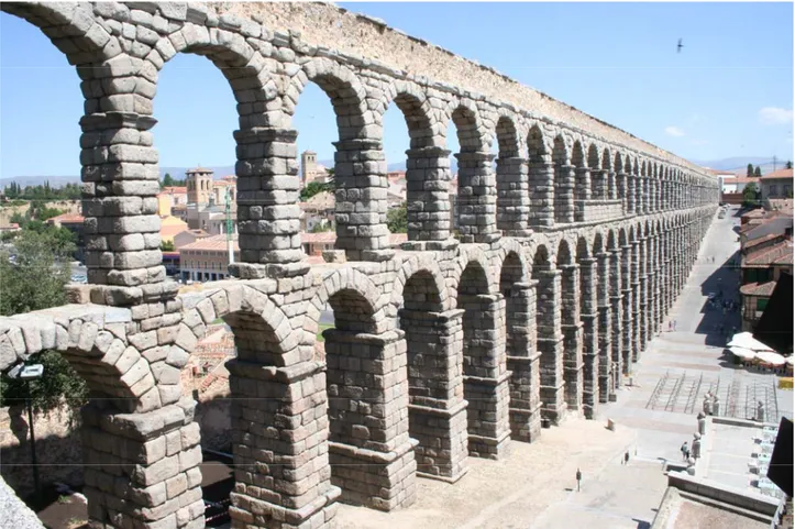
Fig. n° 1.3 Flood event of Marta River, 16th December, 2008 (photo by Filippo Salvo,
www.marinavelca.com).
So a proper basin management is needed to correctly manage flow conditions in the river, ensuring the minimum flow requirement for ichthyic life and reproduction, providing water for irrigation needs, allowing hydro-electrical energy production, making tourism industry flourishing, improving water quality and avoiding saltwater intrusion phenomena at the mouth of the stream.
All the local authorities are directly involved in facing and solving the several and different management aspects of the basin and efficient and operative planning actions are hoped to prevent and control environmental damage and to ensure citizens safety.
Since no plan or action has been set out for this basin, with the exception of a piece of artificial dyke realized along the last stretch of the river not so far from the mouth, the urge of rational and incisive intervention is more and more deeply felt among people.
Choosing Marta river basin as study area for the MEDDMAN project had the meaning of a technical contribution in hydrologic behavior investigation and planning definition in order to point
__________________________Chapter 1-Integrated Natural And Water Resources Manangement
out an integrated management scheme for a correct and rational water and natural resources exploitation taking into account not only the environmental preservation but also the anthropic impact and needs. From a cultural and society requirements point of view, it seems to be time for considering also anthropic activity as an element of the environmental system that is as a part of it in interaction with all the rest. As a consequence, the sustainable development strategy for natural systems comes out (Leone et al., 1999). Applying these general concepts to agriculture, guidelines for a concrete definition of sustainable agriculture can be obtained (Leone et al., 1997). Politic and administrative tools to face Marta River basin planning are available and these tools could be seen as a synthesis of an advanced society which is no more threaten by the spectrum of hunger and poverty and is no more looking at rural land as the means to satisfy its primary needs (Leone et al., 1996).
Coupling all these aspects and integrating information about the different forms of management and planning, a deep hydrological analysis of Marta River Basin was carried out as basis of investigation on the watershed behavior, laying the foundations for a suitable River Basin Planning and a DSS (Decision System Support) which integrates environmental aspects, both agronomic and socio-economics ones, relating to water resources quality and availability.
The aim of this research is, exactly, a deep study of the watershed characteristics and responses to meteo-climatic and anthropic constraints and the creation of a Decision System Support, DSS, based on the implementation of a physically based hydrologic model, SWAT model, and on a saltwater intrusion sharp interface model, SHARP in a recent modified version Sharp_sar to predict eventual seawater wedge movement phenomena in the coastal aquifer Maremma Laziale at the mouth of the river. The organization of all the available data in a GIS platform which was essential to the SWAT and SHARP model application.
SWAT is a three-dimensional / continuous time watershed model operating on a daily time step at the basin scale and it’s a continuation of USDA-ARS modeling experience that spans a period of roughly 30 years. Early origins of SWAT can be traced to previously developed USDA-ARS models as described by Arnold and Fohrer (2005) and Krysanova et al. (2005). The major objective of the model is to predict long term impacts of management and agricultural practices in large basins within a year (i.e., crop rotations, planting and harvest dates, irrigation, fertilizer, and pesticide application rates and timing). It can be used to simulate water and nutrient cycles in landscapes where the dominant land use is agriculture. It can also help in assessing the environmental efficiency of best management plans and alternative management policies. The chemicals considered in the model include nutrients (N-based, P-based, O-based and algae) and pesticides.
__________________________Chapter 1-Integrated Natural And Water Resources Manangement
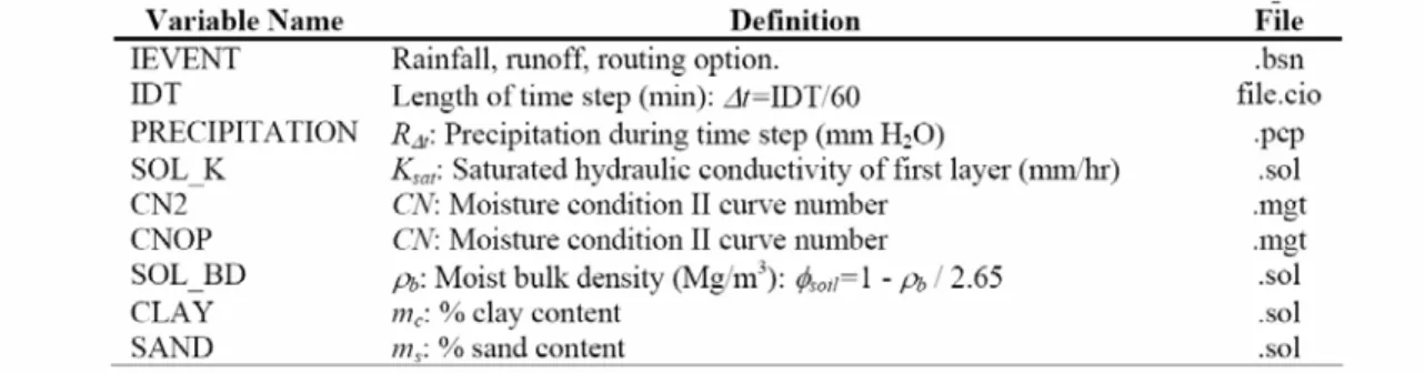
Climatic, soil classes and properties, land use and anthropic pressure data are required for SWAT model running.
SHARP simulates freshwater and saltwater flow separated by a sharp interface in layered coastal aquifers accounting for temporal variations in recharge and pumping. For the considered aquifer, the vertically integrated freshwater and saltwater flow equations are solved and coupled by the boundary condition at the interface. Morphologic and geologic characteristic but also climatic and meteo-hydrographic characteristics of the coastal area are needed in order to implement such a sharp interface model.
The results from these two models application and all the deriving considerations could be directed toward supporting water resources planning, policy making and management eventually through development of a strategy that aims to consider several issues associated with the core problem of developing multiple sources and managing multiple uses (municipal, industrial, irrigation) of water and natural resources so that, over time, more efficient environmental resources exploitation systems and use patterns emerge, while maintaining or improving ambient water quality.
__________________________________________Chapter 2-Hydrologic Modeling and Planning
CHAPTER 2
HYDROLOGIC MODELING AND PLANNING
Hydrologic modeling has become commonplace over the last 25 years and now virtually all hydrologic design is based on the results of applying a hydrologic model. The ready availability of models and computers and the “user-friendly” nature of many hydrologic models ensures continued and absolute reliance on such models. Haan et al. (1982) presented a detailed treatment of hydrologic modeling for small watersheds. The availability of very complex hydrologic models has strongly improved our ability to perform sophisticated and accurate hydrologic analysis so that many different designs can be evaluated at minimal cost once baseline data are collected. Today software not only provides hydrologic analysis but also suggests appropriate model parameters using “pop-up” screens and professional-look reports can be prepared almost automatically.
Models are used for a variety of hydrologic studies and probably the most common use is to evaluate the impact of some physical change or land use within a catchment on its hydrology. The model must contain parameters sensitive to the phenomena taking place: for example if the model has no way to reflect the modifications occurring on an internal channel, it’s obviously not able to define its hydrologic behavior. Nonpoint-source pollution concerns has led to regulatory requirements for showing how land management will mitigate adverse water quality impacts and now most of the available models are required to predict the potential effectiveness of various control efforts such as best management practices.
Once a model is operational for a single catchment then combinations of storage, channel modifications and land use changes can be modeled even tending to an economic objective that could result in considerable savings over the life of the presumed project. If a planning administration has a development plan for a particular area and a timetable for that plan, a hydrologic model can be used to determine the type and timing of various storm water control works required to meet an agreed on flow objective. It is the case of Marta river basin which is under anthropic pressure heavy modifying its hydrologic response with considerable consequences on flora and fauna and above all on human safety so that a basin plan should be hoped. To reconstruct the hydrologic behavior of this system and to better design a suitable plan, a hydrologic model should be very useful.
There is also a great tendency for planners to consider each development unit as a separate entity and design conveyance and storage facilities independently for that particular unit. But it has to be noted the great advantages of considering storm water management on regional basis and the hydrologic model makes it feasible to evaluate the impact of a structure or plan locally and its
__________________________________________Chapter 2-Hydrologic Modeling and Planning
regional impact as well. A well-conducted model study requires detailed knowledge of the system being modeled but models also allow and encourage the use of “what if” scenarios and the use of innovation.
Hydrologic models have been classified in many ways such as deterministic, parametric, statistical, stochastic, physically based, empirical, black-box, lumped, linear, non-linear, distributed, theoretical, predictive, operational, research, design, similarity, iconic, analog, numerical, regression, even, continuous simulation and conceptual (Haan , Barfield, Hayes, 1994).
Generally speaking, a mathematical model range from single prediction equations to complex computer simulation algorithms and the mathematical basis for that model may be theoretical or empirical.
A completely theoretical model would contain only relationships derived entirely from physical laws such as conservation of mass, conservation of energy, laws of thermodynamics etc. Empirical relationships are based on observations and/or experimentation such as Manning’s equation for uniform open channel flow or the Darcy’s law fro flow through a porous media. There exists no completely theoretical model in hydrology since all hydrologic models contain empirical relationships. So that a hydrologic model can be better defined as a collection of physical laws and empirical observations written in mathematical terms and combined in such a way as to produce hydrologic estimates (outputs) based on a set of known and/or assumed conditions (inputs) (Haan , Barfield, Hayes, 1994).
Regardless of how models are classified, they can generally be described as:
(
I P t)
ef
O= , , + (2.1) Where O is an n x k matrix of hydrologic responses to be modeled, f is a collection of l functional relationships, I is an n x m matrix of inputs, P is a vector of p parameters, t is time, e is an n x k matrix of errors, n is the number of data points, k is the number of responses and m is the number of inputs. Responses in O may range from a single number, such as a peak flow or a runoff volume, to a continuous record of flow, soil water content, evapotranspiration, and other quantities. Model classification refers to the nature of f. The distinction between I and P is not always clear where I generally represents inputs, some of which are time varying, such as rainfall, temperature and land use while P represents coefficients particular to a watershed that must be estimated from tables, charts, correlations, observed data, or some other means. The error term, e, represents the difference between what actually occurs, O, and what the model predicts, Op:
__________________________________________Chapter 2-Hydrologic Modeling and Planning
(
I P t f Op = , ,)
(2.2) p O O e= − (2.3) A parametric model is a model having parameters that must be estimated based on observed data (calibration), tables and/or charts (Manning’s n or Curve Number), correlation-type relations (regional analysis) of site-specific information (water-holding capacities of soils etc), experience, or by some other means. An empirical model is a model containing any empirical relationship based on observation and even Darcy’s law or Manning’s equation are empirical equations. A lumped model describes processes on a scale larger than a point. A completely distributed model would be one in which all processes are described at a point and then integrated over three-dimensional space and time taking into account variations in space and time to produce the total watershed response. Based on somewhat restrictive definitions, all hydrologic models are to some degree parametric, empirical, and lumped.2.1 A brief look back
Many of the current developments in hydrologic modeling depend more heavily on computational improvements than on improved representations of hydrologic processes when compared to models of 25-30 years ago.
The 1960’s might be thought as the golden years for hydrologic modeling since computers were becoming widely available and hydrologic researchers began taking advantage of their power. The Stanford Project in Hydrologic Simulation was initiated in 1959 and, under the general leadership of R.K. Linsley, developed approaches to hydrologic modeling that continue to play a major role in this field to this day. The most famous of the models developed at Stanford was the Stanford watershed Model, SWM (Crawford and Linsley, 1962 and 1966). In their 1966 report, Crawford and Linsley stated:
“The objective of the research is to develop a general system of quantitative analysis for hydrologic regimes. The most effective way or doing this has been to establish continuous mathematical relationships between elements of the hydrologic cycle. The operation of these mathematical relationship is observed and improved by using digital computers to carry the calculations forward time…. As mathematical relationships are developed, every attempt is made to realistically reproduce physical processes in the model. Experimental results and analytical studies are used wherever possible to assist in defining the necessary relationships.”
This statement of their researchers objective has been paraphrased and repeated by others in many locations throughout the world.
__________________________________________Chapter 2-Hydrologic Modeling and Planning
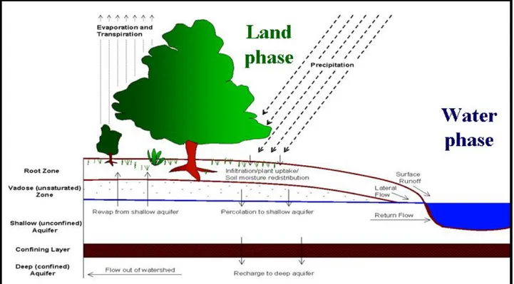
Fig. n° 2.1 A representation of the hydrologic cycle.
In 1966, Huggins and Monke (1966) presented the first developments of what has become known as ANSWERS (Beasley and Huggins, 1981). This model is representative of a class of models that breaks a watershed into a grid system, simulates the hydrology of each grid and interaction of the grids with their neighbors integrating these results over the watershed to produce the total watershed response. Generally with models of that type, the goal is to use physically based parameters, since a set of parameters must be defined for each grid within the watershed. In addition to general purpose models applicable to a wide range of watersheds, hydrologic models have been developed to address specific questions. The model developed at Iowa State University (Haan and Johnson, 1968; DeBoer and Johnson, 1971; Campbell et al., 1974) to evaluate the impact of subsurface drainage on flood flows in north central Iowa represents such a model.
Since the 1960’s there have been thousands of papers, articles and books written dealing with hydrologic modeling. In these years hydrologic modelers spent a great deal of time justifying with hydrologic models should be developed and their applicability to certain problems. Today everyone
__________________________________________Chapter 2-Hydrologic Modeling and Planning
wants to use models for every conceivable hydrologic question and their implementations are often outside the verified domain of the model being used. But many modern hydrologic investigations would not be possible without computer models.
2.2 Basic modeling approaches
One way of differentiating hydrologic models is based on time scale of importance, so that to have two main approaches: event simulation and continuous simulation. Event simulation refers to modeling the hydrologic response to a single isolated storm while continuous simulation refers to modeling the ongoing hydrology of a catchment over a long period of time (years). To design storm water control facilities for small catchment, event based models are useful while continuous models are used where long term flow volumes and storage considerations are important. Hydrologic models are constructed on the base of flow and storage processes considering not only the inflow and outflow of water to the system in a hydrologic cycle, but also other factors such as solar radiation and air masses that play an important role since they import energy to drive evaporative processes and govern vegetative growth, which in its turn, influences evapotranspiration.
Also the capacity limits in the various storage (bank storage, channel storage, flood plain storage etc., see Fig. n° 2.1, the rate of release of water from the storage and the rate of water movement in the various flow phases must be taken into account. It’s really important to define the processes in as physically based a manner as possible so that model parameters can be almost conceptually, if not actually, related to physical watershed characteristics.
For example, soil water storage might be referred to the available water-holding capacity of the soil in the root zone and soil water flow processes might related to the water-transmitting properties of the soil. In general, event-based models requires less detailed information than continuous simulation models and often subsurface flow processes and abstractions with the exception of infiltration, evapotranspiration and baseflow are neglected in event-based models based on time scale and order of magnitude arguments. An event simulation model is built combining algorithms representing flow and storage processes in a logical manner and providing a means of estimating the various parameters required as a result of the representations.
A continuous simulation model is always much more complex than an event one where the complexity is increased as the step is decreased: if a 1 day time step is used in a small catchment, detailed overland flow routing and infiltration calculations cannot be done and in this case the storage processes become dominant in the model. For an event-based model a short time increment is used and for small catchments the time increment is in minutes. For an event-based model, antecedent conditions in terms of soil storage, have to be specified or implicitly assumed by the
__________________________________________Chapter 2-Hydrologic Modeling and Planning
model. Another classification concerns the manner to represent physical processes. Processes and parameters can be defined as average representations over the entire watershed or specified at points or within cells and then integrated over the watershed to define the total basin response. The former approach is termed as lumped and the latter distributed. So that distributed models represent averages over some finite area (a hectare or so) being lumped to some extent while lumped models may be applied to very small catchments with the results combined and routed. In this way, lumped models may become distributed models. Whether the model is distributed or lumped, event-based or continuous, parameters must be correctly estimated to evaluate the flow and storage processes.
2.3 Parameter estimation
To estimate model parameters some criteria must be adopted and they may include: 1) personal judgment of goodness of fit of simulated hydrographs to observed hydrographs, 2) direct measurement of physical properties in the field or in the lab, 3) indirect measurement of physical properties through their relationship with other hydrologic processes and watershed characteristics, 4) optimization of some objective function either computationally or by trial and error, 5) satisfaction of agency requirements and 6) compliance with published tables and charts. But it is often hard to define the appropriate criteria for parameters selection, to find correlation among parameter due to the amount of computation involved in many models, to the restrictions on appropriate values for some of the parameters and to the non-uniqueness of parameters sets for certain objective functions and finally due to data errors.
Problems in parameters estimation have been investigated by Dawdy and O’Donnel (1965) foreseeing the possibility of obtaining an efficient automatic procedure for finding numerical values of the various parameters of a watershed model. Beard (1967) and DeCoursey and Snyder (1969) addressed computer procedures to estimate optimal parameters for a hydrologic model. Jackson and Aron (1971) reviewed parameter evaluation techniques in hydrology. An objective function is often a minimization of a sum of squares and search techniques were employed to find the parameter set optimizing such an objective function. Sorooshian (1983) shifted his attention from a deterministic, mathematical interpretation of parameters toward a stochastic interpretation of them.
For Klemes (1982) causal models were being viewed as “somewhat structured empirical constructs whose elements are egression coefficients with physical sounding names” and the adoption of this viewpoint led to parameter estimation in a statistical framework and focused attention on treating a parameter as a random variable with a probability density function. Troutman (1985) made an extensive investigation referring to this approach. The majority of the research was on the evaluation of parameters using a single objective function related to the prediction of peak flow or
__________________________________________Chapter 2-Hydrologic Modeling and Planning
storm runoff volumes or daily stream-flow. Diskin and Simon (1977) investigated 12 such univariate objective function while attempts to use multiple objectives have been reported by Edwards (1988) applying them to the Soil Conservation System (SCS) runoff model. If model parameters estimation is based only on the minimization of prediction error sum of squares for peak flow for example, then the resulting parameter set would be reliable in predicting peak flows but give very poor estimates of runoff volumes.
If interest is on runoff peaks, then choice of the simpler univariate objective function may be useful; however the estimated parameters may be skeptical when the poorly estimated SCS curve number parameter is compared to more conventional estimates of this parameter as commonly found in tables. So to overcome this problem, a measure of prediction errors on volumes was included in the objective function. Runoff typically accounts for only 10 to 35% of annual runoff and estimation of all models parameters based only on runoff ignores 65 to 90% of the processes due to water loss for a catchment.
There’s no clear justification on the thought that if runoff is well predicted then all model parameters must have been adequately determined and including some measure of performance in the optimization that reflects some of the flow and storage processes occurring within a watershed in addition to runoff should improve the stability (reducing variance) and accuracy (reducing the absolute error) of the evaluated parameters. Traditionally, parameter estimation criteria measured how well predicted stream flow agreed with observed stream flow but these criteria are really difficult to apply especially for continuous models.
An alternative could be the measure of performance as how well the model performs in a design situation for example selecting the parameters of a daily flow model so that the estimated capacity of a reservoir to meet some demand would be as close as possible to the capacity estimated on the basis of observed stream flow data using the same capacity estimation algorithm.
2.4 Parameter estimation criteria
Parameter estimation methodologies can be divided into two main categories: personal and objective. The first one relies on a personal judgment of the modeler while objective parameter optimization generally deals with some function of the error term, e of Eq. n° 2.3 and thus requires observed data on the quantity being modeled. A probability density function for e, as well as other properties such as independence, constant variance, and zero mean is assumed. Generally e is a function of the parameters P.
__________________________________________Chapter 2-Hydrologic Modeling and Planning
2.4.1 Personal parameter estimation
The most commonly used parameter estimation technique is the personal judgment of the modeler where parameters are initially assigned on the basis of judgment, published guides and physical properties and characteristics of the watershed and then adjusted again based on judgment as to the appropriateness of the model results. If observed data are available, the parameters may be adjusted several times in an effort to obtain a “satisfactory” fit to the observations. This method has the advantages to weight mentally the importance of various flow components such as peak flows, low flows, runoff volumes whereas most objective estimation techniques can focus only on a single objective. But it has the disadvantages of sole reliance on the judgment of the modeler and generally a poorly defined objective function in the mind of the user. Different hydrologists would arrive at different parameters assessment on the basis of the same model using the same data.
2.4.2 Least Squares
In the last squares procedure, a sum, S, is defined as the sum of squares of the ei :
∑
= = n i i e S 1 2 (2.4)Values of the p parameters minimizing the sum S are sought. For hydrologic models, numerical search techniques are generally employed in p-dimensional space.
2.4.3 Absolute Errors
To minimize the absolute errors a sum A has to be computed:
∑
= = n i i e A 1 2 (2.5)Values of parameters minimizing A in p-dimensional parameter space are sought, generally through numerical search techniques.
2.4.4 Method of Moments
This method requires equating the first p sample moments of epwith the first p population moments of the pdf (probability density function) of e. The population moments will be a function of the p model parameters so that to have p equations in p unknowns to be solved for values of the p unknown parameters.
2.4.5 Maximum Likelihood
__________________________________________Chapter 2-Hydrologic Modeling and Planning
(
e P p L i n i / 1 = ∏ =)
(2.6) Where p(ei/P) is the pdf of e given P. Values of P that maximize L are sought and for hydrologic models, numerical search techniques are generally required.2.4.6 Arbitrary Objective Functions
Any objective function or criterion function, C, can be used to find P and in general:
( )
( )
[
f O f O]
G[
f( ) ( )
O f P]
G
C = i , 2 p = 1 , 3 (2.7) Where G is the arbitrary function, f1 is a function of the observed values of O, and f2 is a function of the estimated values of Op. Using numerical search techniques, P optimizing C is sought so for example f1=ln(O), f2=ln(Op) and
[
( )
( )
]
2 2 1
∑
−= f O f Op
G and P is found minimizing G.
This would be a minimization of the sum of squares of the difference in the logarithms of the observed and predicted outputs. For all the above four estimation procedures, e is a n x 1 vector, point estimates for the parameters are obtained, and a single objective is used.
2.4.7 Bayesian Estimation
This procedure is different from the above methods cause it evolves from probabilistic considerations rather than some arbitrarily specified objective function. Bayesian estimation is concerned with the probability distribution of the parameters rather than point estimates. However point estimates may be derived as the mode of the resulting distribution.
Some references to Bayesian estimation are Box and Tiao (1973), Kuczera (1983), Vicens et al. (1975), Edwards (1988) and Edwards and Haan 81988, 1989). Bayesian estimation has the advantage that multiple objectives may be incorporated into the analysis. Box and Tiao (1973) show that the point estimates for P may be found by minimizing the determinant of S(P), |S(P)|, with respect to P, where S(P) = e’ e for the case where e is a n x k matrix of sums of squares and cross products of errors. Since |S(P)| is simply a number (the determinant of e’e), numerical search procedures can be used to find the P that minimizes |S(P)|.
2.4.8 Considerations
James and Burges (1982) present an excellent discussion of parameter estimation and estimation criteria. If a model structure is such that only a subset of parameters impact one particular aspect of model output, those parameters may be estimated on the basis of an optimization criteria related to that particular aspect of model output. While strict division of influence between parameter sets and
__________________________________________Chapter 2-Hydrologic Modeling and Planning
outputs generally does not occur, it is common for some parameters to have relatively little influence on optimization criteria and thus be poorly determined. James and Burges (1982) define sensitivity coefficients that can help identify this possibility. To include multiple objectives, a weighted criterion function could be used:
∑
∑
+ = 2 2 2 2 1 1 e w e w C (2.8) Where the subscripts refer to different objectives (i.e., peaks and volumes), w is a weight and e is the error. The selection of the weights is arbitrary and reflect the relative importance of the two objectives. In that interaction between the two objectives is not included. For the case where k=2 it’s:(
2 2 1 2 2 2 2 1∑
∑
∑
− = e e ee C)
(2.9) This equation can be generalized to any number of objectives and it is not necessary that all ei used in that equation be related to flow. For example e2 might refer to some measure of soil water content if observed data were available and the model provided estimates of soil water.2.5 Event modeling
Event based models are used to describe the response of a catchment to a single hydrologic event or rainstorm thus components of the model must deal with the characteristics of the input rainstorm, abstractions from the rainfall, routing of overland and shallow subsurface flow to the channel system and finally the routing of the channel flow to the catchment outlet. Model development becomes one of choosing algorithms for representing the various model components and combining them in a logical and functional manner to produce a runoff hydrograph. For example a SCS type II rainfall distribution can be used to define the storm input, the curve number approach to determine abstractions from rainfall, the SCS curvilinear unit hydrograph for overland and shallow subsurface flow routing and the Muskingum routing procedure for channel routing. A basin to be modeled may also be divided in subcatchments defining the physical properties of them so that to combine the responses obtained and have the total catchemnt hydrograph. In a modeling effort such as this, the manner in which catchments are defined can have a pronounced influence on the conclusion reached. It is also useful to point out the possibility to resort to lumping and the impact of lumping on results: if the effect of a small change on a large watershed is to be investigated, the lumping of the area undergoing change with the rest of the catchment will often mask any impacts so generally, catchments with widely varying characteristics should not be lumped. Basins with different land uses, soils, surface topography, stream characteristics, etc, should be identified and treated separately with the flow combined through a routing process (Haan, Barfield, Hayes, 1994).