CORSO DI DOTTORATO IN AMBIENTE E TERRITORIO
CICLO XXIV
S.S.D. BIO/07
TITOLO TESI
ASSESSMENT OF RIVER ECOSYSTEMS BY A MULTITEMPORAL AND MULTILAYERED LANDSCAPE APPROACH. THE SEMIAQUATIC OTTER (LUTRA
LUTRA L) AS A PARADIGMATIC SPECIES.
TUTOR:
Prof. Maria Laura Carranza
COORDINATORE:
Prof. Claudio Caprari
CO-TUTOR:
Prof. Anna Loy
Ph.D. Tiziana Simoniello
CANDIDATO
1 1) Preface
Among wetlands, fluvial habitats represent key ecosystems for maintaining the general equilibrium of the entire landscape (Ward et al., 2002a) since they contribute to sustain a high level of biodiversity (Naiman et al., 1993), act as environmental corridors (Knutson & Klaas, 1998), and are depurating organisms with many functional links with the surrounding territory (Brunet & Astin, 1997; He et al., 2000; Ingegnoli, 2002; Sponseller et al., 2001; Stewart et al., 2001). Nevertheless, in the last 30 years, river ecosystems have been severely menaced by many anthropogenic pressures (Tockner et al., 2010; Schinegger et al., 2011), such as channelization and bank stabilization (Ward, 1998), erosion (Montgomery, 1999), land use (Allan, 2004), pollution (Ormerod et al., 2010) and so on.
In order to maintain the crucial role of river ecosystems in keeping the equilibrium of the entire landscapes, the European Union adopted the Water Framework Directive 60/2000/CE, that aims at the recovering of a satisfactory functional level of European water bodies within the year 2015. The main environmental objectives of the Water Directive are the protection, the improvement and the restoration of water bodies. For reaching this aims, specific monitoring campaigns must be implemented and a correct management of each river basin based on those monitoring information must be drawn. For the achievement of Water Directive objectives, scientifically based strategies that take into account the multilayered structure of the river/landscape systems are mandatory. River basins, in fact, are dynamic mosaics of spatial elements and ecological processes hierarchically organised (Frissell et al., 1986; Schumm et al. 1988, Lowe et al., 2006; Huang et al., 2007).
In a stream ecosystem it is possible to recognise at least three major layers, such as stream channel, floodplain, and transitional upland areas; all these layers interact and work dynamically in the landscape basin (Ward, 2002a). The interactions between these layers are essential for preserving the natural functionality and biodiversity in the river basin: e.g. cycling nutrients, filtering possible contaminants from runoff, absorbing and gradually releasing floodwaters, supporting fish and wildlife habitats, recharging ground water, maintaining stream flows and go further. The connections between the river courses and their surrounding and upland areas have been well acknowledged in literature (Richards et al., 1996; Bis et al., 2000; Snyder et al., 2003), which define a stream and its involved landscape as a continuous and integrated hydro-system (Ward et al., 2002a). In this context a disturbed landscape influences the river ecosystem and vice-versa (Hem, 1985; Norris and Thoms, 1999; Davies et al. 2000, Miltner et al., 2004; Ahearn et al., 2005; Bunner et al., 2010).
2
In order to provide efficient scientific tools for the monitoring, management and/or restoration of a river/landscape system, a more dynamic assessment, based on the knowledge of key ecological aspects of the different layers, is needed.
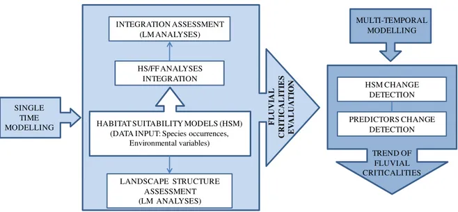
The general aim of the research work was to identify and test a kit of scientifically sound indicators of fluvial basin function and disturbance (criticalities) able to synthesize the multi-layered structure of a river/landscape system.
With this aim in mind we focused on the diverse layers of the river landscape by applying and integrating different approaches.
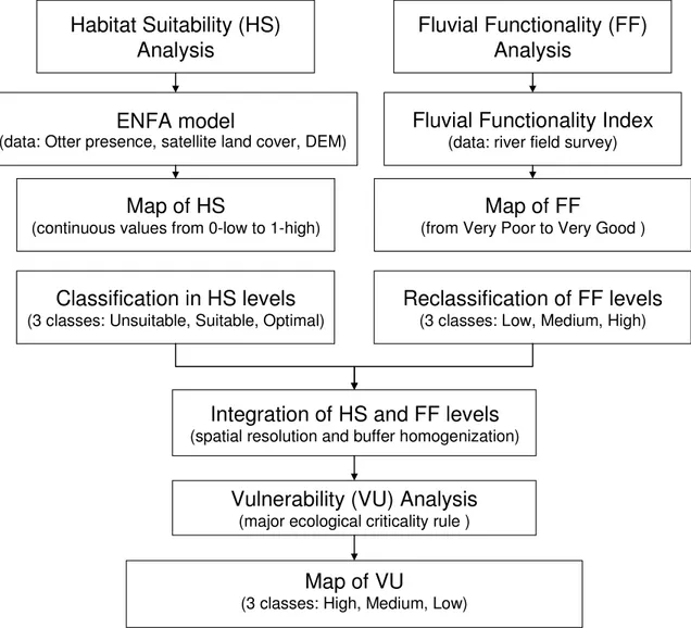
As a synthetic indicator of the entire basin environmental status we used the distribution of suitable habitats for a river key species, provided by the application of an inferential Habitat Suitability Model (Chapter 1).
Next we described the existing links between the river channel and its upland areas by measuring a fine scale index of Fluvial Functionality. Results from both Habitat Suitability model of a key species and Fluvial Functionality analyses were integrated in order to identify the main critical sector of the river basins.
Successively we test the results derived from this integration by calculating a set of landscape ecology Metrics (LM). For this purposes we chose two different river basins showing high (High Agri River, Chapter 2) and low levels of anthropogenic influence (High Sinni River, Chapter 3) respectively. In the more natural/functional river basin additional landscape analysis was performed aimed to identify further links between the water course criticalities and the territory of the entire basin (Chapter 4).
Considering that ecological systems are dynamic and that river systems tend to change in considerable short time we also implemented a multi-temporal HS model approach. In particular we produced two inferential Habitat Suitability Models concerning different periods (years 1985 and 2006) and we compared them in order to identify the environmental factors that accompanied the natural expansion of the key species (Chapter 5).
A schematic representation of the research work is depicted in Figure 1, which follows a detailed introduction of the treated topics along with the relative scientific articles.
3 TREND OF FLUVIAL CRITICALITIES SINGLE TIME MODELLING HS/FF ANALYSES INTEGRATION LANDSCAPE STRUCTURE ASSESSMENT (LM ANALYSES) INTEGRATION ASSESSMENT (LM ANALYSES)
HABITAT SUITABILITY MODELS (HSM) (DATA INPUT: Species occurrences,
Environmental variables) F L U V IA L C R IT IC A L IT IE S E V A L U A T IO N MULTI-TEMPORAL MODELLING HSM CHANGE DETECTION PREDICTORS CHANGE DETECTION
Figure 1: Flow-Chart of the proposed approach: in light blue the single-time step modelling regarding the different
performed analyses and providing fluvial criticalities at a specific time; in blue the multi-temporal step modelling providing the fluvial criticalities trend. HS (Habitat Suitability), LM (Landscape Metrics), FF (Fluvial
Functionality).
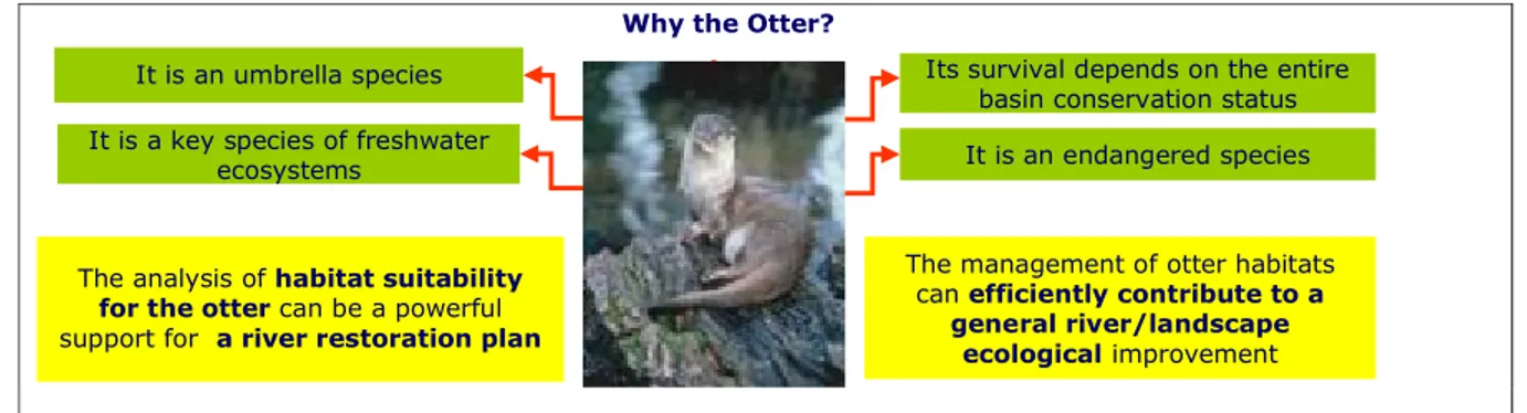
For the research we used the spatial distribution of a wide-ranging key species, particularly vulnerable to the environmental quality and equilibrium of fluvial habitats, as a broad scale surrogate of good ecological functioning of the river basin: the Eurasian otter (Lutra lutra L.). This species relies on the river course and on the riparian vegetation for feeding, for resting and for reproductive activities (Chanin, 2003; Kruuk, 2006). It is also linked to the presence and structure of natural and semi-natural elements in the terrestrial matrix for inter-catchment dispersal movements and gene flow (Carranza et al., 2012). In Italy, the species was distributed over the whole country till the 70’s when it started to decrease (Spagnesi et al., 2000). In the 90’s otters resulted relegated to a Southern Italy range, geographically isolated from the European population, and for this reason it was listed as critically endangered (CE IUCN category - Bulgarini et al., 1998). The causes of Otter decline included illegal hunting, food shortages (mainly fish), and the destruction of riparian vegetation (Loy et al., 2010). At present, the Otter’s Italian population consists of two isolated sub-populations that are slowly recovering: a core area represented by the Campania, Basilicata, Calabria and Apulia regions and an outlying area in the Molise region (Loy et al. 2010).
4 2) Study area and Methods
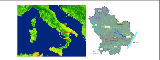
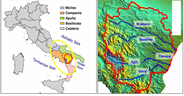
The research was carried out in Basilicata Region (Southern Italy) that comprises the following five river catchments: Sinni, Agri, Cavone Basento and Bradano (Figure 2).
This area played a crucial role for the survival of the Italian remnant Otter population in the period 1970-1990, and it represents a consistent sector of its current range.
Bradano Cavone Sinni Agri Basento A A B B C C C C Altitude 0 - 250 250 - 500 500 - 750 750 - 1000 1000 - 1250 1250 - 1500 1500 - 1750 1750 - 2000 2000 - 2250 River Network Natura2000 Sites
C - Gallipoli Cognato Regional Park B - Pollino National Park A - Central Apennines National Park
0 10 20 Kilometers
N E W
S
Figure 2: Left: study area. Right: the rivers included in the study region along with the Natura 2000 Sites and the
EUAP areas. In yellow Natura 2000 Sites; in light blue, A, Central Apennines National Park; in light green, B, Pollino National Park; in pink, C, Gallipoli-Cognato Regional Park.
To describe the spatial distribution of the Otter, we used Habitat Suitability Models (HSMs) and maps. Otter Habitat Suitability maps, describing the quality and distribution of river habitats, can be considered a proxy of the functions and critical aspects on river ecosystems. HS models, generating maps of species suitable habitats distribution, are a powerful instrument for the description of the species environmental niche (Hirzel et al., 2002; Araújo & Guisan, 2006) and can be considered fundamental for providing a geographic perspective on supporting conservation strategies both for the chosen species and for the ecosystem that enclose them (see e.g. Mladenoff et al., 1997; Guisan & Zimmermann, 2000). Many HSMs have been produced for a variety of common species (Guisan & Zimmermann, 2000, Elith et al., 2006; Guisan & Thuiller, 2005; Jiménez-Valverde et al., 2008 and reference therein), but their use for modelling the distribution of endangered species has not been sufficiently exploited yet (Elith et al., 2006; Engler et al., 2004; Guisan et al., 2006, Lomba et al., 2010). Furthermore, the integration of HS models with environmental indices describing other ecological levels of organization (as ecosystems and landscape) has been quite unexplored.
5
We used two different HS modelling approaches: the ENFA model (Hirzel et al., 2002), and the multi-modelling BIOMOD platform (Thuiller, 2009).
We first selected the ENFA model because it produces reliable results by using only-presence data (Cianfrani et al., 2010).
On this subject see Chapter 1:
• "Carone M.T., Simoniello T., Loy A. e M.L. Carranza et al (2010): Individuation of fluvial areas needing restoration through the analysis of a target species, the Eurasian otter (Lutra lutra L.). Extended abstract 7th European Conference on Ecological Restoration, Avignon, France. SER Europe Knowledge Base (www.ser.org/europe). Habitat Suitability Models produced with ENFA were then integrated with fine scale information derived from Fluvial Functionality analysis.
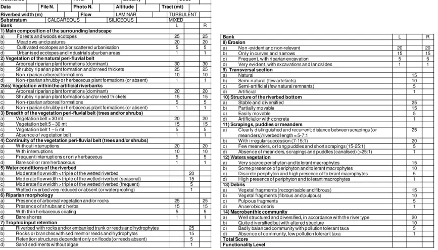
Considering the river as an “organism”, the Fluvial Functionality describes the health of its metabolic functions due to both: the living structure (e.g. trophical chain) and the environmental frame (e.g. fluvial contributions to the environmental biodiversity, solid transport loads, etc) (Vannote et al., 1980). Many Fluvial Functionality Indices have been developed in different environmental situations and countries (e.g., AUSRIVAS - Australian River Assessment System, Parsons et al., 2002; ISC - Index of Stream Condition, Ladson et al., 1996; RHS - River Habitat Survey Raven et al., 1997; IFF – Indice di Funzionalità Fluviale, Siligardi et al., 2003a) all of them aimed to provide an efficient and synthetic description of fluvial metabolic functions. Being the Fluvial Functionality indices operational tools for the assessment of the river metabolic functions (e.g. Ladson et al., 1996; Raven et al., 1997), they can support the evaluation of river criticalities at the local scale. In Italy, Balestrini et al. (2004), have demonstrated that the IFF is more adapt for evaluating the functionality of rivers than other Fluvial Functionality indices, such as the Buffer Strip Index, and the Wild State Index (Braioni & Penna, 1998). At present the IFF is adopted by the Italian Governmental Agency of Environmental Protection, ISPRA (Siligardi et al., 2003a) and a wide scientific literature underlined that it is a robust tool for the assessment of fluvial functioning (e.g. Comiti et al., 2009; Mazza et al., 2011; Munafò et al., 2005; Renai et al., 2006; Siligardi et al., 2003b; Siligardi & Cappelletti, 2006). For all the above mentioned reasons in the present research we used the Italian protocol for Fluvial Functionality (IFF - Siligardi et al., 2000; Siligardi et al., 2003a).
The integration of FF parameters with maps of HS for fluvial key species (Otters) was used for identifying the river sectors with different vulnerability levels (VU), providing a prioritization that is essential for individuating the river tracts needing urgent specific restoration
6
actions. In order to integrate HS and FF data, both suitability and functionality values were categorized into three levels (low, medium, and high suitability/functionality) and combined in a GIS environment to obtain three levels of river Vulnerability (VU). In this way, each Vulnerability level synthesizes information coming from both the broad (HS) and the fine scale (FF) of river system and for this reason gives an efficient description of the river health status. Then we analyzed land-cover fragmentation inside each original (Functionality, Suitability) and derived map (Vulnerability).
In particular we concentrate our attention on natural cover types because its fragmentation strongly modifies the river ecological functions at different scales (e.g. Lindenmayer & Fischer, 2006 and references therein) and it influences the entire fluvial ecosystems (King et al., 2005; Carone et al., 2009; Karaburun & Demirci, 2009). Furthermore, although there is an open debate about the significance of Landscape Metrics in absolute terms (e.g. Dramstad et al., 2002), the efficacy of such indices in terms of relative values is widely accepted in literature (e.g. Dramstad et al., 2002; Peng et al., 2010; Renetzeder et al., 2010; Zhou et al., 2011) and their effectiveness on describing landscape structure is acknowledged (see e.g. Leitão & Ahern, 2002; Peng et al., 2010; Colson et al., 2011).
In our specific case for each thematic map (HS, FF and VU) classified in three levels (low, medium, and high) we performed a fragmentation analysis based on land cover distribution.
Then we compared the behaviour of the analyzed Landscape Metrics (McGarigal et al., 2002) on the different thematic levels.
On this subject see Chapter 2, and Chapter 3:
• “Carone M. T., Simoniello T., Loy A., Carranza, M. L. (2011) Integration of Ecological Niche Factor Analysis and Fluvial Functionality in vulnerability assessment for supporting restoration strategies in fluvial habitats. Submitted to Ecological Indicators” (data: authors sent a revised version concerning a minor/major revision);
• “Carone M. T., Simoniello T., Loy A., Carranza, M. L. (2011) Combining habitat suitability models and fluvial functionality data for a multilayer assessment of riverine vulnerability: a second study case. In: Jørgensen S.E. and Jordán F. (Eds.) “Models of the Ecological Hierarchy: From Molecules to the Ecosphere” Series on Developments in Environmental Modelling, Elsevier”. (data: authors sent a revised version concerning a minor revision);
7
An extra landscape pattern analysis was realized on the more natural test area (High Sinni River), oriented to further investigate on the structure and functioning of the entire river basin (Freeman and Ray, 2001; Rob et al., 2002; Ward et al., 2002a,b,c; Wiens, 2002; Wozniak et al., 2009; Tockner et al., 2009). We obtained in this way stronger basis for an adequate management and restoration of fluvial habitats (Poudevigne et al., 2002, Cote et al., 2009).
On this subject see Chapter 4:
• “Carone M.T., Simoniello T., Coppola R., D’Emilio M., Lanfredi M., Proto M., Carranza M.L., Loy A., Macchiato, M., 2010. Analysis of landscape structure and connectivity at watershed scale. Fresenius Environmental Bulletin, 19(10a): 2361 – 2366.”
In the last research period we performed multi-temporal habitat suitability models for the Eurasian otter. Considering that land use change constitutes one of the most severe causes of habitat loss for wildlife (Sala et al., 2000), we used past and current otter presence data and land use changes in time to model the otter distribution and to identify critical areas for the survival and expansion of the species. We were specifically interested in accounting for shifts in the distribution of otter occurred between the past contraction period and the current expansion phase (Loy et al., 2009). The basic idea was that insights on environmental predictors driving past and current species distribution would likely allow to better identify the limiting factors for the otter survival at a regional scale, and contribute to raise the accuracy and reliability of the model itself.
The habitat suitability for the European otter was assessed in the Italian core area of the species in a 21 years interval (from1985 to 2006), using an ensemble niche modelling approach (BIOMOD Thuiller, 2009). Such an approach was applied in order to test previous modelling results and, as suggested by many authors (e.g. Araújo and New, 2007; Elith et al, 2006; Le Lay et al., 2010; Pearsons et al., 2002; Thuiller, 2004), to improve the final product.
On this subject see Chapter 5:
• "Carone M.T., Simoniello T., Cianfrani, C., Loy A., Guisan A., Carranza, M.L.: Habitat suitability for the endangered species Eurasian otter in Southern Italian river basins. A multi-temporal approach”.
8
Since all the results provided by the analyses described so far can be produced as maps, the use of GIS technologies and remote sensing data represent the most appropriate tools for the various steps implementation. In particular, remote sensing data allows for a satisfactory discriminating ability, coherent with the purposes of the approach, and provide the possibility to easily repeat the modelling in time (map update) and to test the territory changes over large areas at relatively low cost (Simoniello et al., 2004; Carone et al., 2009).
For the present study we chose to produce land-cover maps derived from a fuzzy supervised classification (Schowengerdt, 2007) of a high resolution satellite image acquired by the Landsat-TM sensor, taking into account that this sensor offers a good compromise between the area coverage (~180 square kilometers) and the spatial resolution (30 m), and proved to be useful for the land cover characterization at basin scale in the study area (Carone et al., 2009; Liberti et al., 2009).
3) Final remarks
The obtained results demonstrated that distribution models for a key aquatic species can be considered as robust indicators of the fluvial health status. In particular the choice of the European otter as target species correctly capture the complexities of the ecosystem, which is crucial for defining indicators aiming to monitoring purposes, as underlined by Dale & Beyeler (2001).
The integration of Habitat Suitability models with information on Fluvial Functionality and its successive combination with parameters of fragmentation, effectively synthesized the relation between the functionality of the water courses, the landscape structure and the distribution of the studied key species. This integration represents a helpful tool for understanding the effect of anthropogenic pressures on the river functionality. Furthermore this approach resulted very effective for the identification of the most vulnerable fluvial tracts, allowing for a correct planning of the necessary restoration interventions. Since the prioritization of fluvial conservation interventions represents a crucial challenge for defining a sustainable environmental management (see e.g. Mainstone, 2010; Thompson, 2010; Suding, 2011), the proposed approach provides a basis for an interesting perspective that should be further explored. The multi-temporal analysis of Otter distribution evidenced that the improvement of Otter population is coherent with the recovering of natural land covers on the studied territory, as indicated, but not tested by precedent studies (see e.g. Remonti et al., 2008; Loy et al., 2009; Loy et al., 2010). In particular the results confirm the essential role of riparian vegetation along
9
the river courses (Loy et al, 2010 ) and the widespread natural inter-catchment matrix (Carranza et al, 2012) for the Otter survival and expansion.
Finally, considering that, at present, the conservation of biodiversity represents an urgent challenge (see e.g. Rands et al., 2010; European Directive 92/43/CE, European Directive 97/62/CE; European Directive 2006/105/CE; www.iucnredlist.org) and a correct management of endangered species is the most effective way for preserving a satisfactory biodiversity level (see e.g. Lopez-Toledo et al., 2011; Scott et al., 2010; Strayer & Dudgeon, 2010), the proposed approach represents a concrete answer, among the others, for dealing with the conservation of river’s biodiversity and function.
4) Strengths of the approach and elements of novelty compared to existing literature
• HSM on single data and multi-temporal data: we built two HSM for two data (1985 and 2006) based on a multi-temporal dataset (otter surveys and land cover data), we assessed, then, the relation between landscape change, suitable habitat distribution and real presence data. While the predictions of species expansion on virtual scenario are widely challenged (see e.g. Rushton et al., 2004; Elith & Leathwick, 2009), model validations based on real multi-temporal data have not been addressed so far.
• Test region in a core area: the approach has been tested in the Italian Otter core area. This aspect is particularly important because 1) generally core areas represent key source regions for the conservation of remnant populations; 2) for the studied species such areas represents its only possibility to recover and spread again (in Italy reintroductions are not possible, since the genetic pool of the populations breaded in captivity include elements from areas abroad the Italian territory); 3) the natural recover of the species in Italy starts from the core areas and is actually going on in their borders (Loy, 2009);
• Single and Multi-models approach: the analysis utilized both a single-model (ENFA; Hirzel, 2002) based on presence data, and a multi-model approach (BIOMOD; Thuiller, 2009), based on presence/pseudo-absence data. The results will give the possibility to make, as a further exploration, a comparison between the different applied methods, which have great differences on hardware and time consuming. Such a comparison, unlike others realized among ENFA and different modelling approaches (see e.g. Tsoar et al., 2007), has been rarely addressed (Elith & Leathwick, 2009);
10
• Multi-layered approach: the method takes into account the multi-layered structure of the studied system and integrate indicators referring to each existing layer. An integration of general indicators relying on Fluvial Functionality and Habitat Suitability is still unexplored;
• Test with Landscape Metrics: the landscape ecology analyses give the opportunity to point out the main criticalities on the structure of the studied landscapes (e.g. the eventual increasing of fragmentation). If the use of Landscape metrics (McGarigal et al., 2002) for the analysis of environmental mosaic structure is widely addressed, their application for the assessment of other approaches (here the assessment of the proposed approach) is still quite unexplored;
• Use of Satellite data: the elaboration of the environmental data concerning land use has been realized by means of high resolution satellite data; this choice provides the possibility to easily repeat the modelling in time (HS map update), testing the territory changes over large areas at relatively low cost.
5) Forthcoming perspectives
The proposed approach can be further exploited taking into account the following : 1) Habitat Suitability (HS) Analyses
a. For building HSM of a core area also real absence data should be taken into account in order to better describe the realized spatial niche;
b. the examination of other environmental variables, not available at the moment (e.g. fish diversity and abundance, surface runoff), should be considered in order to improve the method;
c. by considering the existing consistent difference between ENFA and BIOMOD time and hardware commitment, a focused comparison of their results should provide a helpful basis for choosing the right modelling tool in cases of specific requested analysis time or held technical equipment.
2) Integration between HS and Fluvial Functionality (FF) analyses
a. The application of the HS and FF integration at fluvial basins showing more consistent anthropogenic influences would represent a further test on its reliability and then, an eventual strengthening of its exportability and efficacy.
11
a. Further assessments by means of the application of Landscape Metrics can be provided for the additional application of HS and FF integration;
b. Landscape metrics analyses should be realized both on the studied landscapes and on the obtained HS maps, with the aim to point out the existing links between these two structures.
Aknowledgements
I want to warmly thank all the persons that contributed to the realization of this Ph.D. Thesis: • My family and my friends, for the patience and the affection shown to me in these three
years of work;
• My cousin and its family for their support in the Suisse land;
• People from DEE (Department of Ecology and Evolution) in Losanna (CH), for their precious scientific contribution, in particular Prof. A. Guisan.
References
1. Ahearn, D.S., Sheibley R. W., Dalgran R. A., Anderson M., Johnson J., Tate K. W. (2005) Land use and land cover influence on water quality in the last free-flowing river draining the western Sierra Nevada, California. Journal of Hydrology, 313(3-4), 234-247. 2. Allan, J.D. (2004) Landscapes and Riverscapes: the influence of land use on stream
ecosystems. Annual Review of Ecology, Evolution, and Systematics, 35, 257-284.
3. Araújo, M.B. & Guisan, A. (2006) Five (or so) challenges for species distribution modelling. Journal of Biogeography, 33(10), 1677-1688.
4. Araújo, M.B. & New, M. (2007) Ensemble forecasting of species distributions. Trends in Ecology and Evolution, 22(1), 42-47.
5. Balestrini, R., Cazzola, M., Buffagni, A. (2004) Characterizing Hydromorphological Features of Selected Italian Rivers: a comparative application of environmental indices. Hydrobiologia, 516, 365 – 379.
6. Bis, B., Zdanowicz, A., Zalewski, M. (2000) Effect of Catchment Properties on Hydrochemistry, Habitat Complexity and Invertebrates Community Structure in a Lowland River. Hydrobiologia, 422/423, 369-387.
7. Braioni, M.G. & Penna, G.(1998) I nuovi indici ambientali sintetici di valutazione della qualità delle rive e delle aree riparie: Wild State Index, Buffer Strip Index, Environmental Landscape Indices: il metodo. Biologia Ambientale, 6, 3-38 (In Italian).
12
8. Brunet, R.C. & Astin, K.B. (1997) Spatio-Temporal Variations in Sediment Levels: the River Adour. Landscape Ecology, 12, 171 – 184.
9. Bulgarini, F., Calvario, E., Fraticelli, F., Petretti, F., Sarrocco, S. (1998) Libro Rosso degli animali d’Italia. Vertebrati. WWF, Roma.
10. Bunner, S.E., Abal, E.G., Smith, M. J., Choy, S.C., Fellows, C.S., Harch, B.D., Kennard, M.J., Sheldon, F. (2010) Integration of science and monitoring of river ecosystem health to guide investments in catchment protection and rehabilitation. Freshwater Biology, 55(s1), 223-240.
11. Carone, M. T., Simoniello, T., Manfreda, S., Caricato, G. (2009) Watershed influence on fluvial ecosystems: an integrated methodology for river water quality management. Environmental Monitoring and Assessment, 152(1-4), 327-342.
12. Carranza, M.L., D’Alessandro, E., Saura, S., Loy, A. (2012) Assessing habitat connectivity for semi- aquatic vertebrates. The case of the endangered otter in Italy. Landscape Ecology, 27:281–290
13. Chanin, P. (2003) Ecology of the Eurasian otter. Conserving Natura 2000 Sites. Rivers Ecology. Series N° 10. English Nature, Peterborough .
14. Cianfrani, C., Le Lay, G., Loy, A., Hirzel, A. H. (2010) Do habitat suitability models reliably predict the recovery areas of threatened species? Journal of Applied Ecology, 47 (2), 421-430.
6) Colson, F., Bogaert, J., Ceulemans, R. (2011) Fragmentation in the Legal Amazon, Brazil : Can landscape metrics indicate agricultural policy differences? Ecological Indicators, 11, 1467-1471.
1. Comiti, F., Mao, L., Lenzi, M.A., Siligardi, M. (2009) Artificial steps to stabilize mountain rivers: a post-project ecological assessment. River Research and Applications, 25, 639-659.
2. Cote, D., Kehler, D.G., Bourne, C., Wiersma, Y. (2009) A new measure of longitudinal connectivity for stream network. Landscape Ecology, 24(1), 101-113.
3. Dale, H.V. & Beyeler, S.C. (2001) Challenges in the development and use of ecological indicators. Ecological Indicators, 1(1), 3-10.
4. Davies, N.M., Norris R. H., Thoms M. C. (2000) Prediction and Assessment of Local Stream Habitat Features Using Large-Scale Catchment Characteristics. Freshwater Biology, 45, 343–369.
5. Dramstad, W.E., Fjellstad, W.J., Strand, G.H., Mathiesen, H.F., Engan, G., Stokland, J.N. (2002) Development and implementation of the Norwegian monitoring programme for agricultural landscapes. Journal of Environmental Management, 64, 49-63.
13
6. Elith, J., Graham, C.H., Anderson, R.P., Dudik, M., Ferrier, S., Guisan, A., Hijmans, R.J., Huettman, F., Leathwick, J.R., Lehmann, A., Li, J., Lohmann, L., Loiselle, B.A., Manion, G., Moritz, C., Nakamura, M., Nakazawa, Y., Overton, J.M., Peterson, A.T., Phillips, S., Richardson, K., Schachetti Pereira, R., Schapire, R.E., Soberón, J., Williams, S.E., Wisz, M., and Zimmermann, N.E. (2006) Novel methods improve predictions of species' distributions from occurrence data. Ecography, 29, 129-151.
7. Elith, J. & Leathwick J.R. (2009) Species distributions models: ecological explanation and prediction across space and time. Annual Review of Ecology, Evolution and Systematics, 40, 677-697.
8. Elith, J. & Leathwick J.R. (2009) Conservation prioritization using species distribution modelling. Accepted in: A. Moilanen, K. A. Wilson, and H. P. Possingham, editors. Spatial conservation prioritization: quantitative methods and computational tools. Oxford University Press.
9. Engler, R., Guisan, A., Rechsteiner, L. (2004) An improved approach for predicting ther distribution of rare and endangered species from occurrence and pseudoabsence data. Journal of Applied Ecology, 41, 263-274.
10. Freeman, R.E. &, Ray, R.O. (2001) Landscape Ecology Practice by Small River Conservation Groups. Landscape and Urban Planning, 56,, 171 – 184.
11. Frissell, C. A., Liss, W. J., Warren, C. E., Hurley, M. D. (1986) A Hierarchical Framework for Stream Habitat Classification: Viewing Streams in a Watershed Context’, Environmental Management, 10, 199–214.
12. Guisan A. & Thuiller, W. (2005) Predicting species distribution: offering more than simple habitat models. Ecology Letters, 8, 993-1009.
13. Guisan A. & Zimmermann N.E. (2000) Predictive habitat distribution models in ecology. Ecological Modelling, 135, 147-186.
14. Guisan, A., Broennimann, O., Engler, R., Yoccoz, N.G., Vust, M., Zimmermann, N.E:, Lehmann, A. (2006) Using niche-based modelst to improve the sampling of rare species. Conservation Biology, 20, 501-511.
15. He, C., Malcolm, S. B., Kenneth, A.D., Fu, B. (2000) A Conceptual Framework for Integrating Hydrological and Biological Indicators into Watershed Management. Landscape and Urban Planning, 49, 25 – 34.
16. Hem, J. (1985) Study and Interpretation of the Chemical Characteristics of Natural Water. United States Geological Survey Water. Supply Paper 2254, Washington, DC. 17. Hirzel, A.H., Hausser, J., Chessel, D., Perrin, N. (2002) Ecological-niche factor analysis:
14
18. Huang, S.L., Budd, W.W., Chan, S.L., Lin, Y.C. (2007) Stream order, hierarchy , and energy convergence of land use. Ecological Modelling, 205(1-2), 255-264.
19. Ingegnoli, V. (2002) Landscape Ecology: a Widening Foundation. Springer Verlag Ed., Berlin.
20. Jiménez-Valverde, A., Lobo, J.M., Hortal, J. (2008) Not as good as they seem: the importance of concepts in species distribution modelling. Diversity and Distribution, 14, 885-890.
21. Leitão, B.A. & Ahern, J. (2002) Applying Landscape Ecological Concepts and Metrics in Sustainable Landscape Planning. Landscape and Urban Planning, 59, 65-93.
22. Karaburun, A., Demirci, A. (2009) The changing risks of agricultural activities on water resources in rapidly urbanize areas: agricultural land cover change in Istanbul between 1987 and 2007. Fresenius Environmental Bulletin, 18(11a), 2181-2191.
23. Knutson, M.G. & Klaas, E.E. (1998) Floodplain Forest Loss and Changes in Forest Community Composition and Structure in the Upper Mississippi: a Wildlife Habitat at Risk. Natural Areas Journal, 18, 138 – 150.
24. Kruuk, H. (2006) Otters, ecology, behaviour and conservation. Oxford University Press, Oxford.
25. Ladson, A., Doolan, J., White, L., Metzeling, L., Robinson, D. (1996) Index of Stream Condition as a Tool to Aid Management of Rivers [online]. In: Hydrology and Water Resources Symposium (23rd : 1996 : Hobart, Tas.). Hydrology and Water Resources Symposium 1996: Water and the Environment; Preprints of Papers. Barton, ACT: Institution of Engineers, Australia, 325-331.
26. Le Lay, G., Engler, R., Franc, E., Guisan, A. (2010) Prospective sampling based on model ensemble improve the detection or rare species. Ecography, 33, 1015-1027.
27. Liberti, M., Simoniello, T., Carone, M.T., Coppola, R., D’Emilio, M., Macchiato, M. (2009) Mapping badlands areas using LANDSAT TM/ETM satellite imagery and morphological data. Geomorphology, 106, 333-343
28. Lomba, A., Pellissier, L., Randin, C., Vicente, J., Moreira, F., Honrado, J., Guisan, A. (2010). Overcoming the rare species modelling paradox: A novel hierarchical frame work applied to an Iberian endemic plant. Biological Conservation, 143, 2647 – 2657.
29. Lopez-Toledo, L., Ibarra-Manríquez, G., Burslem, D.F.R.P., Martínez-Salas, E., Pineda-García, F., Martínez-Ramos, M. (2011) Protecting a single endangered species and meeting multiple conservation goals: an approach with Guaiacum sanctum in Yucatan Peninsula, Mexico. Diversity and Distribution, doi: 10.1111/j.1472-4642.2011.00857.x
15
30. Loy, A., Boitani, L., Bonesi, L., Canu, A., Di Croce, A., Fiorentino, P. L., Genovesi, P., Mattei, L., Panzacchi, M., Prigioni, C., Randi, E., Reggiani, G. (2010) The italian action plan for the endangered Eurasian otter Lutra lutra. Hystrix Italian Journal of Mammalology (n.s.), 21(1), 19-33.
31. Loy, A., Carranza, M.L., Cianfrani, C., D’Alessandro, E., Bonesi, L., Di Marzio, P., Minotti, M., Reggiani, G. (2009) Otter Lutra lutra population expansion: assessing habitat suitability and connectivity in south-central Italy. Folia Zoologica, 58(3), 309-326. 32. Lowe, W.H., Likens, G.E., Power, M.E. (2006) Linking Scales in Stream Ecology.
BioScience, 56(7), 591-597.
33. Mainstone, C.P. & Holmes, N.T.H. (2010) Embedding a strategic approach to river restoration in operational management processes-experiences in England. Aquatic Conservation: Marine and Freshwater Ecosystems, 20(1), S82-S95.
34. Mazza, G., Agostini, N., Aquiloni, L., Carano, G., Inghilesi, A.F., Tricarico, E., Gherardi, F. (2011) The indigenous crayfish Austropotamobius pallipes complex in a national park of Central Italy. Knowledge and Management of Aquatic Ecosystems, 401, 24-35.
35. McGarigal, K., Cushman, S. A., Neel, M. C., Ene, E. (2002) FRAGSTATS: Spatial Pattern Analysis Program for Categorical Maps. Computer Software Program Produced by the Authors at the University of Massachusetts, Amherst. Available at the following web site: www.umass.edu/landeco/research/fragstats/fragstats.html
36. Miltner, R.J., White, D., Yoder, C. (2004) The biotic integrity of streams in urban and suburbanizing landscapes. Landscape and Urban Planning, 69(1), 87-100.
37. Mladenoff, D.J., Haight, R.C., Sickley, T.A., Wydeven, A.P. (1997) Causes and implications of species restoration in altered ecosystems: a spatial landscape projection of wolf population recovery. Bioscience, 47, 21-31.
38. Montgomery, D.R. (1999) Process domains and the River Continuum. Journal of the American Water Resources Association, 35(2), 397-410.
39. Munafò, M., Cecchi, G., Baiocco, F., Mancini, L. (2005) River pollution from non-point sources: a new simplified method of assessment. Journal of Environmental Management, 77, 93-98.
40. Naiman, R.J., Décamps, H., Pollock, M. (1993) The Role of Biodiversity in Maintaining Regional Diversity. Ecological Applications, 2, 209-212.
41. Norris, R.H. & Thoms, M.C. (1999) What is River Health? Freshwater Biology, 41: 197 – 209.
42. Ormerod, S.J., Dobson, M., Hildrew, A.G., Townsend, C.R. (2010) Multiple stressors in freshwater ecosystems. Freshwater biology, 55(s1), 1-4.
16
43. Pearsons, M, Thoms, M, Norris, R (2002) Australian River Assessment System: AUSRIVAS Physical Assessment Protocol, Monitoring River Health Initiative. Technical Report No 22. Commonwealth of Australia and University of Canberra. ISBN 0 642 54888 9, ISSN 1447 1280. http://ausrivas.canberra.edu.au/Geoassessment/Physchem/ 44. Peng, J., Wang, Y., Zhang Y., Wu, J., Li, W., Li, Y. (2010) Evaluating the Effectiveness
of Landscape Metrics in Quantifying Spatial Patterns. Ecological Indicators, 10(2), 217 – 223.
45. Poudevigne, I., Alard, D., Leuven, R.S.E.W., Nienhuis, P.H. (2002) A Systems Approach to River Restoration: a Case Study in the Lower Seine Valley, France. River Research and Applications, 18, 239 – 247.
46. Rands, M.R.W., Adams, W.M., Bennun, L., Butchart, S.H.M., Clements, A., Coomes, D., Entwistle, A., Hodge, I., Kapos, V., Scharlemann, J.P.W., Sutherland, W.J., Vira, B. (2010) Biodiversity Conservation: Challenges Beyond 2010. Science, 329(5997), 1298-1303.
47. Raven, P.J., Fox, O.P., Everard, M., Holmes, N.T.H., Dawson, F.H. (1997) River habitat survey: a new system for classifying rivers according to their habitat quality. In: Freshwater Quality – Defining the Indefinable (Eds. P.J. Boon & D.J. Howell), The Stationary Office, Edinburgh, 215–234.
48. Remonti, L., Prigioni, C., Balestrieri, A., Sgrosso, S., Priore, G. (2008) Distribution of a recolonising species may not reflect habitat suitability alone: the case of the Eurasian otter (Lutra lutra) in southern italy. Wildlife Research, 35, 798-805.
49. Renai, B., Bertocchi, S., Brusconi, S., Gherardi, F., Grandjean, F., Lebboroni, M., Parinet, B., Souty Grosset, C., Trouilhe, M.C. (2006) Ecological characterization of streams in Tuscany (Italy) for the management of the threatened crayfish Austropotamobius pallipes complex. Bulletin Français de la Pêche et de la Piscicolture, 380-381, 1095-1114.
50. Renetzeder, C., Schindler, S., Peterseil, J., Prinz, M.A., Mücher, S., Wrbka, T. (2010) Can we measure ecological sustainability? Landscape pattern as an indicator for naturalness and land use intensity at regional, national and European level. Ecological Indicators, 10(1), 39-48.
51. Richards, C., Johnson, L.B., Host, G.E. (1996) Canadian Journal of Fisheries and Aquatic Sciences, 53(1), 295-311.
52. Rushton, S.P., Ormerod, S.J., Kerby, G (2004) New paradigms for modelling species distributions? Journal of Applied Ecology, 41(2), 193-200.
17
53. Rob, S.E.W., Leuven, R.S.E.W., Poudevigne, I. (2002) Riverine Landscape Dynamics and Ecological Risk Assessment. Freshwater Biology, 47(4), 845-865.
54. Sala, O.E., Chapin, F.S., Armesto, J.J., Berlow, E., Bloomfield, J., Dirzo, R., Huber-Sanwald, E., Huenneke, L.F., Jackson, R.B., Kinzig., A., Leemands, R., Lodge, D.M., Mooney, H.A., Oesterheld, M., Poff, N.L., Sykes, M.T., Walker, B.H., Walker, M., Wall, D.H. (2000) Global biodiversity scenarios for the year 2100. Science, 287 (5459), 1770-1774.
55. Schinegger, R., Trautwein, A.M., Schmutz, S. (2011) Multiple human pressures and their spatial patterns in European running waters. Water and Environment Journal, doi: 10.1111/j.1747-6593.2011.00285.x
56. Schumm, S. A. (1988) Variability of the Fluvial System in Space and Time. In: T. Rosswall, R. G. Woodmansee and P. G. Risser (eds), Scales and Global Change, John Wiley & Sons, Chichester, 225–250.
57. Schowengerdt, R.A. (2007) Remote Sensing Models and Methods for Image Processing, Elsevier-Academic Press, 3rd Edition, ISBN 10:0-12-369407-8.
58. Scott, J.M., Goble, D.D., Haines, A.M., Wiens, J.A., Neel, M.C. (2010) Conservation-reliant species and the future of conservation. Conservation Letters, 3(2), 91-97.
59. Siligardi, M., Bernabei, S., Cappelletti, C., Chierici, E., Ciutti, F., Egaddi, F., Franceschini, A., Maiolini, B., Mancini, L., Minciardi, M.R., Monauni, C., Rossi, G., Sansoni, G., Spaggiari, R., Zanetti, M. (2000) I.F.F. Indice di Funzionalità Fluviale, Manuale ANPA. Agenzia Nazionale per la Protezione dell’Ambiente. Roma (In Italian). 60. Siligardi, M., Bernabei, S., Cappelletti, C., Chierici, E., Ciutti, F., Egaddi, F.,
Franceschini, A., Maiolini, B., Mancini, L., Minciardi, M.R., Monauni, C., Rossi, G., Sansoni, G., Spaggiari, R., Zanetti, M. (2003a) I.F.F. Indice di Funzionalità Fluviale. Manuale APAT, Agenzia per la Protezione dell'Ambiente e per i Servizi Tecnici. Roma (In Italian).
61. Siligardi, M. & Cappelletti, C. (2006) A New Approach to Evaluating Fluvial Functioning (FFI): Towards a Landscape Ecology. In: Biological Monitoring of Rivers: Applications and Perspectives (eds G. Ziglio, M. Siligardi and G. Flaim), John Wiley & Sons, Ltd, Chichester, UK. doi: 10.1002/0470863781.ch21.
62. Siligardi, M., Pozzi, S., Monauni, C., Fuganti, A. (2003b) Riparian Forestry Project (RipFor): the ecological part on the River Fersina (Trentino, Italy). Study Trent. Sci. Nat., Acta Biologica, 80, 147-152.
63. Simoniello T., Carone M.T., Lanfredi M., Macchiato M., Cuomo V. (2004) Landscape-scale characterization of vegetation phenology using AVHRR-NDVI and Landsat-TM
18
data. In: Remote Sensing for Agriculture, Ecosystems, and Hydrology V, Eds: Manfred Owe; Guido D'Urso; Jose F. Moreno; Alfonso Calera, SPIE, 5232, 644-651.
64. Snyder, C.D., Youg, J.A., Villella, R., Lemarié, D.P. (2003) Influences of Upland and Riparian Land Use Patterns on Stream Biotic Integrity. Landscape Ecology, 18, 647 – 664.
65. Spagnesi, M., Toso, S., De Marinis, A. M., (Eds) (2000) I Mammiferi d’Italia, Istituto Nazionale per la Fauna Selvatica, Ozzano Emilia, Italy (In Italian).
66. Sponseller, R.A., Benfield, E.F., Valett, H.M. (2001) Relationship between land use, spatial scale and stream macroinvertebrates communities. Freshwater Biology, 46, 1409-1424.
67. Stewart, J.S., Wang, L., Lyons, J., Horwatich, J.A., Bannermann, R. (2001) Influences of watershed, riparian-corridor, and reach scale characteristics on aquatic biota in agricultural watersheds. Journal of American Water Resources Association, 37(6), 1475-1487.
68. Strayer, D.L., Dudgeon, D. (2010) Freshwater biodiversity conservation: recent progress and future challenges. Journal of the North American Benthological Society, 29(1), 344-358.
69. Suding, K.N. (2011) Toward an Era of Restoration in Ecology: Successes, Failures and Opportunities Ahead. Ecology, Evolution and Systematics, 42, 465-487.
70. Thompson, B.A. (2010) Planning for Implementation: Landscape-level Restoration Planning in an Agricultural Setting. Restoration Ecology, 19(1), 5-13.
71. Thuiller, W. (2004) Patterns and uncertainties of species’ range shifts under climate change. Global Change Biology, 10, 2020-2027.
72. Thuiller, W. (2009) BIOMOD – A platform for ensemble forecasting of species distributions. Ecography, 32, 369 – 373.
73. Tockner, K., Lorang, M.S., Stanford, J.A. (2009) River flood plains are model ecosystems to test general hydrogeomorphic and ecological concept. River Research and Applications, 26(1), 76-86.
74. Tockner, K., Pusch, M., Borchardt, D., Lorang, M.S. (2010) Multiple stressors in coupled river-floodplain ecosystems. Freshwater Biology, 55(s1), 135-151.
75. Tsoar, A., Allouche, O., Steinitz, O., Rotem, D., Kadmon, R. (2007) A comparative evaluation of presence-only methods for modelling species distribution. Diversity and Distributions, 13(4), 397-405.
19
76. Vannote, R.L., Minshall, G.W., Cummins, K.W., Sedell, J.R., Cushing, C.E. (1980) The River Continuum Concept. Canadian Journal of Fisheries and Aquatic Sciences, 37, 130-137.
77. Ward, J.V. (1998) Riverine landscapes: Biodiversity patterns, disturbance regimes, and aquatic conservation. Biological Conservation, 83(3), 269-278.
78. Ward, J. V., Malard, F., Tokner, K., Arscott, D. B., Claret, C. (2002a) Landscape Ecology: a Framework for Integrating Pattern and Process in River Corridors. Landscape Ecology, 17(1), 35-45.
79. Ward, J.V., Robinson, C.T., Tockner, K. (2002b) Applicability of Ecological Theory to Riverine Ecosystems. Verhandlungen des Internationalen, Verein Limnologie, 28, 443-450.
80. Ward, J.V., Tockner, K., Arscott, D.B., Claret, C. (2002c) Riverine Landscape Diversity. Freshwater Biology, 47(4), 517 – 539
81. Wiens, J.A.(2002) Riverine Landscapes: Taking Landscape Ecology into the Water. Freshwater Biology, 47, 501 - 515.
82. Wozniak, M., Leuven, R.S.E.W., Lenders, H.J.R., Chmielewski, T.J., Geerling, G.W., Smits, A.J.M. (2009) Assessing landscape change and biodiversity values of the Middle Vistula river valley, Poland, using BIO-SAFE. Landscape and Urban Planning, 92(3-4), 210-219.
83. Zhou, W., Huang, G., Pickett, S.T.A., Cadenasso, M.L. (2011) 90 years of forest cover change in a urbanizing watershed: spatial and temporal dynamics. Landscape Ecology, 26, 645-659.
1
Proceedings 7th European Conference on Ecological Restoration Avignon, France, 23-27/08/2010
INDIVIDUATION OF FLUVIAL AREAS NEEDING RESTORATION
THROUGH THE ANALYSIS OF A TARGET SPECIES, THE EURASIAN
OTTER (LUTRA LUTRA L.)
Maria Teresa Carone1,2 – Tiziana Simoniello2 – Anna Loy1 – Maria Laura Carranza1
1 STAT Dpt., University of Molise, C.da Fonte Lappone, 86090, Pesche (IS), Italy, [email protected] 2 IMAA, Italian National Research Council - CNR, C.da S.ta Loja, 85050, Tito (PZ), Italy
Abstract: Fluvial habitats are key ecosystems in maintaining landscape biodiversity for their role as corridors and filtering organisms. Since they are functionally linked to the surrounding territory, the health of riverine fauna populations depends on river/landscape equilibrium. Thus, due to the anthropic pressures that in last decades have damaged many fluvial environments, the identifying of scientifically based management strategies devoted to restore the river environmental sustainability has become urgent. Efficient restoration strategies may be valuable performed by analyzing the environmental needs of target species whose survival depends on the entire basin conservation status, e.g. the Eurasian otter (Lutra lutra). In this work we use a Habitat Suitability model (Ecological Niche Factor Analysis) for the Otter to evaluate the river basin functionality and to identify sectors needing restoration measures. The input data have been land covers (from LANDSAT-TM images), a DEM and a derived SLOPE map; the model was performed in the Otter core area of its Italian range, within a riparian buffer of 300 m, producing a HS final map, categorized into three levels (unsuitable, suitable, optimal). The unsuitable areas represent unbalanced sites in term of ecological equilibrium for Otter habitats and can be used to locate restoration interventions having a general character as well as to refine the analysis for specific restoration activities. In conclusion, the combined use of HS models/satellite data represents a helpful support for management policies efficiently suitable to improve the whole river functionality and to recreate balanced habitats for an endangered species as the Eurasian otter.
Keywords: freshwater habitats, Eurasian otter, appropriate restoration objectives.
Introduction
Among wetlands, fluvial habitats represent key ecosystems for the general balance of landscapes: they contribute to maintain a high level of biodiversity, act as environmental corridors, are depurating organisms with many functional links with the surrounding territory.
In the last decades such a role has been severely deteriorated because of anthropic pressures, thus the need to restore those crucial environments has become urgent. By considering that there are several aspects involved in preserving a satisfactory river ecological equilibrium, a correct individuation of fluvial criticalities indicators aiming at restoration is not easy.
A significant help can be taken by analyzing key species whose survival is strictly linked to the various characteristics of river ecosystems. In this paper we present a study that analyzes the environmental needs of a target species, the Eurasian otter (Lutra lutra) (Figure 1), in order to identify scientifically based management strategies mainly devoted to fluvial habitat restoration.
The management of otter habitats can efficiently contribute to a
general river/landscape ecological improvement It is an umbrella species Its survival depends on the entire
basin conservation status It is a key species of freshwater
ecosystems It is an endangered species
The analysis of habitat suitability for the otter can be a powerful support for a river restoration plan
Why the Otter?
2
Ecological Restoration and Sustainable Development - Establishing Links Across Frontiers
Materials and methods
The studied territory is represented by the main axis of the five principal rivers of the Basilicata region (Southern Italy) and by their tributaries showing Otter presences, Figure 2; such an area represents a consistent portion of the Italian Otter core area.
In order to identify the suitable/unsuitable sites for the Otter presence, we applied on this study area a Habitat Suitability Model, the Ecological Niche Factor Analysis (ENFA, Hirzel et al., 2002). This model, developed on the basis of the Hutchinson (1957) ecological niche concept, compares in a multidimensional space the presence distribution of the studied species with a data set of environmental
variablesdescribing the whole study area.
The input data for the model are represented by topographic data, derived from a DEM of the Basilicata Region, and land covers data, derived from a supervised classification of a satellite image, acquired by the sensor Landsat-TM. Satellite data proved to be very useful to evaluate the river basin status (Carone et. al, 2009), in such a context they were selected in order to reduce the cartography elaboration time, improving the performance of the chosen approach, since only aerial photos have been used for such purposes so far. The acquisition time of the satellite image (19/07/2006) was chosen consistently with the monitoring period for the Otter presences (2002-2006). In particular, the use of a summer image improved the identification of the different land cover classes present over the territory, particularly for shrubs and sclerophyllous vegetation. On the whole, sixteen classes plus water bodies were classified.
Basilicata Basilicata
Figure 2. Area of interest; the studied rivers flow into the Ionian Sea and are: Bradano, Basento, Cavone, Agri and
Sinni, from North to South respectively.
Since the model requires only continuous input, topographic data could be used directly, where the land cover data needed to be transformed in frequency maps. For topography, information on slope and convexity were also considered in addition to the altitude. In order to consider a large area close to the rivers, all the investigations were extended within a fluvial buffer of 300 mt.
The model predictive accuracy was calculated by means of the Boyce index (Boyce et al., 2002), which ranges between 0 and 1. The final product is a Habitat Suitability Map for the Otter, categorized into three levels (unsuitable, suitable, and optimal), which, in our case, represent sites from a high need of prioritization, in term of ecological restoration intervention, to a low need of prioritization.
3
Proceedings 7th European Conference on Ecological Restoration Avignon, France, 23-27/08/2010
Figure 3. Scheme of the utilized approach.
Results and discussion
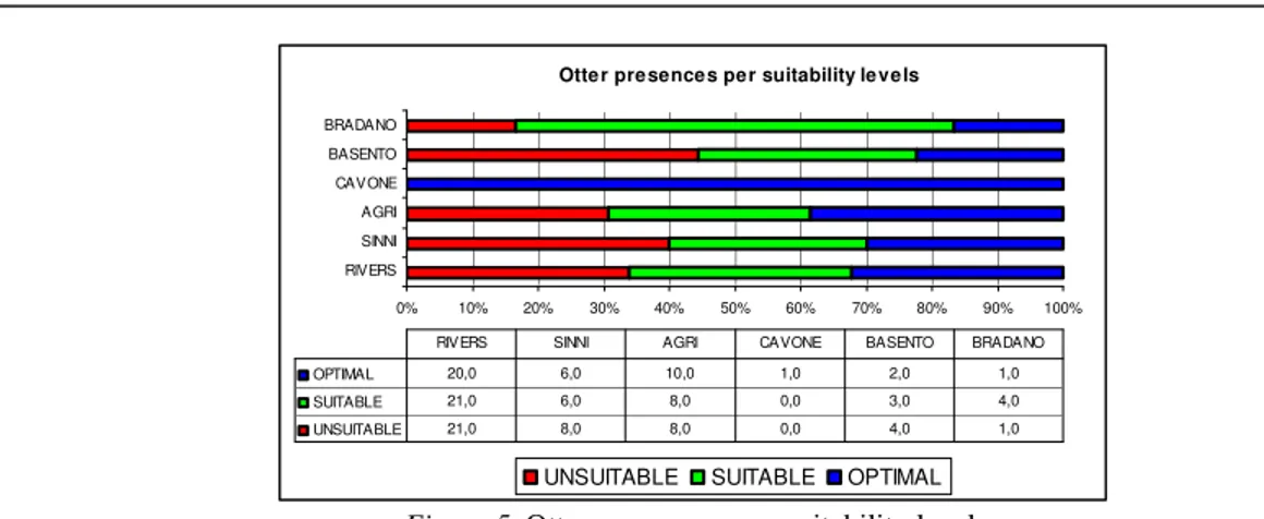
Figure 4a summarizes results obtained from the application of the ENFA Habitat Suitability Model; a zoom in the map for the Sinni River is shown in figure 4b. The calculated Boyce index value for the elaborated suitability map was equal to 0.80.
Figure 4.Distribution of the categorized areas for the investigated rivers (a) and a detail of the Habitat Suitability
Map for the Otter corresponding to the black box: Sinni River (b).
By observing the distributions, it is possible to see as all rivers do not overcome the 50% of suitable/optimal areas. Optimal areas, in particular, have very low values, except for Agri and Sinni Rivers, which, in general, show the highest extension of both suitable and optimal sites. This result is coherent with the general characteristics of the studied riverine landscapes. In fact, the anthropogenic pressures are higher for the Bradano and Basento rivers and lower for the Sinni River, whose basin is partially included in the territory of a National Park; the Agri watershed presents an intermediate condition.
By considering the distribution of the Otter occurrence is evident that the species is more or less homogeneously dispersed among the three suitability levels (Figure 5); only for Bradano River it is possible to observe more presences in suitable sites. This condition however, can be considered predictable, in case of few presences, as for the Bradano basin, because of the low level of inter-individual competition. On the other hand, by observing the structure of suitable/unsuitable patches distribution, we noted an evident fragmentation of such sites.
DEM CONVEXITY SLOPE CONVEXITY SLOPE CATEGORIZATION (THREE LEVELS) PRIORITIZATION SATELLITE DATA (CLASSIFICATION)
HABITAT SUITABILITY MODEL (OTTER)
OTTER PRESENCES
4
Ecological Restoration and Sustainable Development - Establishing Links Across Frontiers
Otter presences per suitability levels
0% 10% 20% 30% 40% 50% 60% 70% 80% 90% 100% RIVERS SINNI AGRI CAVONE BASENTO BRADANO
UNSUITABLE SUITABLE OPTIMAL
OPTIMAL 20,0 6,0 10,0 1,0 2,0 1,0
SUITABLE 21,0 6,0 8,0 0,0 3,0 4,0
UNSUITABLE 21,0 8,0 8,0 0,0 4,0 1,0
RIVERS SINNI AGRI CAVONE BASENTO BRADANO
Figure 5. Otter occurrence per suitability level.
This structure is confirmed by the fact that the presence sites located within unsuitable patches are generally very close to suitable/optimal areas, or included in them, suggesting an influence of those last on the occurrence distribution within unfavourable sites and a general instability of the Otter habitats. Conclusions
From the obtained results it is possible to consider that the Otter habitat in the study area shows a high level of fragmentation, as testified by the Otter presence in unsuitable sites surrounded by suitable/optimal sites. Such a fragmentation regarding suitable areas can be considered a critical stressor for the maintaining of the Otter populations mainly in view of surface covered by those favourable sites, which do not overcome the half of the studied area. By taking into account that the Eurasian otter is a key species linked to all the different aspects of a watershed, and based on the assumption that unfavourable habitats for such species are ecologically unbalanced sites for the fluvial ecosystem we can use the obtained information for suggesting restoration ecology strategies, which can be efficient for the whole river functioning. The categorization of the Habitat Suitability Map for the Otter, in particular, allows for a prioritization of eventual river restoration interventions giving the outmost importance to the unsuitable river stretches showing Otter occurrences. Furthermore, in case of planned interventions, those can be also used for refining the study in view of other more specific restoration activities.
Finally, the combined use of HS models/satellite data gives the possibility to repeat in time the analysis, over large areas, allowing for an efficient monitoring of realized interventions. Thus it represents a helpful support for management policies suitable to improve the whole river functionality and to recreate balanced habitats for an endangered species as the Eurasian otter.
Acknowledgements
We warmly thank Prof. Claudio Prigioni of the University of Pavia, which granted us the use of the Otter presence data.
References
Boyce, M.S., Vernier, P.R., Nielsen, S.E. & Schmiegelow F.K.A. (2002) Evaluating resource selection functions. Ecological Modelling, 157, 281-300.
Carone, M.T., Simoniello, T., Manfreda, S., & Caricato, G. (2009) Watershed influence on fluvial ecosystems: An integrated methodology for river water quality management. Environmental Monitoring and Assessment, 152, 327-342.
Hirzel, A.H., Hausser, J., Chessel, D. & Perrin, N. (2002) Ecological-Niche Factor Analysis: how to compute Habitat-Suitability maps without absence data? Ecology, 83(7), 2027-2036.
1
Integration of Ecological Niche Factor Analysis and Fluvial Functionality in vulnerability assessment for supporting restoration strategies in fluvial habitats
Maria Teresa Caronea,b*, Tiziana Simonielloa, Anna Loyb and Maria Laura Carranzab
a STAT Dpt., University of Molise, C.da Fonte Lappone, 86090, Pesche (IS), Italy, [email protected]
b IMAA, National Research Council of Italy - CNR, C.da S. Loja, 85050, Tito (PZ), Italy
* Corresponding author Abstract
In this paper we propose an integrated approach for the investigation of fluvial vulnerability. We used general indicators linked to different layers of the river system combining analyses of environmental suitability for the Eurasian otter, Lutra lutra L., a keystone species whose survival depends on the entire basins conservation status, with field data on fluvial functionality.
The investigation was performed in a portion of the Agri river basin, located in the Otter core area of Southern Italy (Basilicata region). The test area was chosen for its peculiarities in term of anthropogenic pressures and environmental characteristics. The Habitat Suitability model for the Otter was developed through the Ecological Niche Factor Analysis (ENFA). The analysis of fluvial functionality was carried out through the fieldwork application of the Italian Fluvial Functionality Index (IFF). The final result is represented by a map that integrates the information obtained from the two fluvial and watershed data sets and categorizes the river buffer into three levels of vulnerability. The elaborated suitability, functionality and vulnerability maps were further analyzed by means of Landscape Metrics giving information on fragmentation. Such pattern analysis underlined that, even if the disjointed habitat suitability and fluvial functionality levels are not proportionally linked to the metric values, the integrated vulnerability levels increase from the low to the high values with the fragmentation strength providing also useful ecological information on landscape pattern arrangements. The approach contribute to an efficient characterization of the fluvial vulnerability by summarizing the ecological criticalities related to the different layers. The provided vulnerability levels allow for prioritizing the river segments in term of intervention needs. The method, then, may be considered a robust scientific tool for both management and restoration activities involving fluvial habitats.
Key Words: ecological vulnerability, habitat suitability models, fluvial functionality, satellite images, comprehensive indicators, river management.
2 1. Introduction
For the general balance of landscapes a key role is played by fluvial habitats; they contribute to maintain a high level of biodiversity, act as environmental corridors, and are depurating
organism with many functional links with the surrounding territory (Brunet and Astin, 1997; He et al., 2000; Ingegnoli, 2002; Knutson and Klaas, 1998; Naiman et al., 1993; Sponseller et al., 2001; Stewart et al., 2001; Ward et al., 2002).
In order to maintain such a crucial role, the Water Framework Directive 60/2000/CE establishes that the European water bodies have to recover a satisfactory functional level by 2015. The environmental objectives of this Directive are the protection, the improvement and the
restoration of water bodies by applying specifically devoted monitoring campaigns and also by performing management plan at a river basin scale.
Considering the several aspects involved in preserving a satisfactory river ecological equilibrium, a correct identification of fluvial criticalities indicators is very difficult.
A significant contribution can be provided by the analysis of ecological requirements of wide-ranging species whose survival is strictly linked to the various characteristics of the river ecosystems. From this point of view, the Eurasian otter (Lutra lutra L.) can be considered an ideal target species. This medium sized carnivore is strictly dependent upon pristine freshwater ecosystems, relying on the river for its feeding needs and on the riparian vegetation for its resting and reproductive activities (Chanin, 2003; Kruuk, 2006). Thus, studies based on the analyses of the habitat suitability for this species may be very helpful for identifying scientifically based management strategies mainly devoted to fluvial habitat restoration.
Such an assumption can be particularly true where the Otter shows populations in territories characterized by high anthropogenic pressures as it is the case of Italian river basins. In Italy, in fact, the general deterioration of riverine habitats seems to have heavily affected Otter
populations, and now the species survives only southward, with an outlying area in Molise and a core area in Campania, Basilicata, Calabria and Apulia regions (Loy et al., 2010).
The utilization of habitat suitability models for such semi-aquatic species can represents a good strategy to assess the environmental quality at watershed scale (broad scale). Since the fluvial basin is a multilayered system in which the river shows many fine-scale functional links with its surrounding territory, information at a more detailed scale are also necessary. For this reason, in order to include crucial information at river ecosystem scale (fine scale) and to obtain an efficient characterization of the environmental criticalities of such ecosystems, also data concerning fluvial functionality are mandatory.
3
The fluvial functionality can be described as the well working of the river system, and considers both the trophic relationships between the living organisms and the non-trophic fluvial
contributions to the landscape, such as environmental biodiversity, solid transport loads, etc. (Vannote et al., 1980).
Since analyses taking into account the characteristics of a fluvial system at these different scales and from these points of view have not been realized so far, in this work we tried to combine information derived from Habitat Suitability (HS, hereafter) data for a keystone species (the Otter) with Fluvial Functionality (FF, hereafter) data. The aim of such an integration is to provide a vulnerability assessment (VU, hereafter) of the river system in order to identify the most critical fluvial segments and to suggest priority sites for restoration strategies.
Absence data can be often misleading when analyzing HS, therefore we choose to use the Ecological Niche Factor Analysis (ENFA) model that demonstrated to be robust also in case of database providing only presence data (Cianfrani et al., 2010; Hirzel et al., 2002). For the analysis of the FF, which represents the river ecological equilibrium at ecosystem scale, we choose to apply the Italian Fluvial Functionality Index (IFF) (Siligardi et al., 2003a). This index is widely used for fluvial functionality evaluation both for research studies and for operative assessments (see e.g. Comiti et al., 2009; Mazza et al., 2011; Renai et al., 2006; Siligardi et al., 2003b; Siligardi and Cappelletti, 2006).
Since fragmentation processes heavily influence the ecological equilibrium of landscapes as well as ecosystems and their biological communities (see e.g. Lindenmayer and Fischer, 2006 and references therein), a fragmentation analysis based on a specific set of landscape metrics (McGarigal et al., 2002) can provide precious information on the ability of an indicator to describe the ecosystem vulnerability related to the ecological fragmentation (e.g. Colson et al., 2011; Leitão and Ahern, 2002; Peng et al., 2010).
The work received a further strength by the use of satellite data for the elaboration of the environmental variables related to land use. Satellites allow for gathering information on large areas at relatively low costs. In addition, by exploiting the update frequency (e.g., bi-weekly, monthly) of high-resolution satellite data, it is possible to support the post-intervention monitoring for evaluating the effectiveness and the evolution of implemented activities. The article is structures as follows: first, the study area (2.1) and the methods adopted to implement the proposed integrated approach (2.2-2.5) are presented, jointly with the metrics selected for testing the capability of the methods to represent fragmentation processes (2.6). Then, the results of the separated components at broad and fine scale (3.1-3.2) are shown, followed by the results of data integration and vulnerability assessment (3.3). This section is closed by the fragmentation analysis tests (3.4). Finally are reported the conclusions, from both a
4
practical and an academic point of view, with some suggestions for exporting and testing the approach in different fluvial environments.