The third report on the conservation status of habitats (Directive 92/43/EEC) in
Italy: processes, methodologies, results and comments
L. Zivkovic1, E. Biondi1 , S. Pesaresi1, C. Lasen2, G. Spampinato3, P. Angelini4
1Department of Agricultural, Food and Environmental Sciences (D3A), Marche Politechnic University, Via Brecce
Bianche, I-60131 Ancona, Italy.
2Via Mutten 27, I-32032 Arson di Feltre (BL), Italy.
3Department of Agriculture, Mediterranean University of Reggio Calabria, Località Feo di Vito, I-89124 Reggio
Ca-labria, Italy.
4ISPRA, Institute for Environmental Protection and Research, I-00144 Rome, Italy.
Abstract
We present the third report (2007-2012) on the conservation status of habitats in Italy, made according to Art. ex 17 of Directive 92/43/EEC. We describe, analyze and comment the data relating to the distribution and conservation status of terrestrial habitats on the Italian territory and for each biogeographic region. These data are affected by the scale of investigation planned by the European Union and by the lack of consistent and objective information methods; however they allow to obtain a view of biodiversity in Italy, although incomplete, and provide a valuable guidance for devel-oping environment’s protection and management policies. The large amount of information collected is an important source of georeferenced data with information on the distribution and habitat trends. The analysis of the habitats distribution shows that the largest number of habitats is mainly located in mountainous areas. The reporting data offer a snapshot of the Italian territory characterized by a biodiversity of habitats well distributed throughout the country and in particular in the Natura 2000 sites. The conservation status of habitats is not always satisfactory. Additional long-term monitoring programs are needed, at local, regional or sub-regional scales to allow administrators to properly manage the focal points of their territories. We also propose to make changes in the Habitats Directive increasing the number of habitats to be protected and reassigning the priority of the same at national and sub-national level. We also propose to identify, inside the biogeographical regions, subsectors with a major ecological significance which can be more useful to interpret the habitats. Finally we consider the fragility of many habitats subjected to the effects of global warming and of urban and infrastructure development.
Key words: changes in the Habitats Directive, conservation status of Habitat, Directive 92/43/EEC, distribution of Habitat, global warming, Italy, monitoring of Habitat, Natura 2000 Reporting, third report.
Introduction
The Natura 2000 network, consisting of SCI under the Habitats Directive (92/43/EEC) and SPA under the Birds Directive (2009/147/EC), is the main pillar of Community policy for the conservation of biodiversity in the European Union (Biondi et al., 2012b). The Arti-cle 17 of the Habitats Directive includes an obligation on Member States to draw up every six years a report on the implementation of the provisions adopted under the Directive. The first report for the period 1994-2000 was primarily aimed at transposing the Directive into national laws and the identification phase of the Spe-cial Areas of Conservation (SAC). The second report (2001-2006) for the first time introduced the evalua-tion of the conservaevalua-tion status of habitats and species listed in the Directive Annexes. Because of a lack of sufficient and consistent data throughout the national territory in Italy, as in many other EU states, the sec-ond report was based only on the Natura 2000 network data (Ministero dell'Ambiente e della Tutela del Ter-ritorio e del Mare - Direzione per la Protezione della
Natura, 2008). Despite the publication of guidelines aimed at creating a common methodology between all European countries (European Commission, 2006), the precision and quality of the data provided in the second report and the criteria used to assess the state of conservation of habitats and species were very dif-ferent in difdif-ferent Member States (European Topic Centre on Biological Diversity, 2009; Sipkova et al., 2010). The experience gained from these early reports led the EU to produce new guidelines for the report-ing format for the 2007-2012 period (Evans & Arvela, 2011) in order to further standardize the data collection methodology, making it comparable between several European countries.
The Italian monitoring of habitats for the third Na-tional Report according to art. 17 for the period 2007-2012 was entrusted by the Ministry of Environment and Territory and Preservation of the Sea to the “Isti-tuto Superiore per la Protezione e la Ricerca Ambien-tale” (ISPRA), with contributions from all the Regions and Autonomous Italian Provinces. ISPRA made use of the data collected and processed by the main national Corresponding author: Liliana Zivkovic. Department of Agricultural, Food and Environmental Sciences (D3A),
scientific societies that have been directly responsible for the MATTM. Among these, the Italian Botanical Society (SBI) carried out research on terrestrial habi-tats of Annex I (coordinated by Edoardo Biondi) and the species of Annex II of the Directive (coordinated by Graziano Rossi).
All data of the third National Report of all the Mem-ber States, including Italy, are available on line on the Central Data Repository European Environment Agency (EEA ) or the relevant page of SINAnet of IS-PRA, while further information and documents on art. 17 are located on the site of the European Commission (see more at http://www.minambiente.it/pagina/moni-toraggio-e-rendicontazione#sthash.RW0Kv2Ls.dpuf). In this article we describe, analyze and comment the data relating to the distribution and conservation status of terrestrial habitats of Directive 92/43/EEC (Biondi
et al., 2014). Marine habitats and species included in
Directive (Annexes I, II, IV) are not considered. The data used are affected by the lack of consistent infor-mation on the distribution of habitats throughout the national territory (especially outside the Natura 2000 network) and objective methods in order to assess their condition.
Methodology
The project started activating the process of find-ing information available for the Italian territory by involving both the Administration of the Regions and Autonomous Provinces that the experts of the scien-tific community, in particular the Italian Botanical Society (SBI) and the Italian Society of Science of Vegetation and Landscape (SISV). The data obtained have been used to fill in the reporting format defined by the EC for the period 2007-2012 (European Com-mission, 2011), following the official guidelines (Ev-ans & Arvela, 2011). The reporting format provides for each of the habitats of the Directive a survey at three levels of detail: national, biogeographical region and within the Natura 2000 Network. A distribution map and a range map are required for the entire national territory. For each biogeographical region are required several useful data to evaluate the final status of con-servation of habitats. An example of these data is the current habitat area to be compared with the data of the previous report, so as to define the trend, and with the ideal reference surface. Other information required are threats and pressures to which the habitat is sub-jected and its typical species. Finally the required data at the Natura 2000 network level relate to the habitat area within the sites and the conservation measures implemented. Data on habitats within the Natura 2000 network can be directly found in the standard forms of individual sites, despite out of date. Outside the Natura 2000 network rather homogeneous data are not
avail-able. We thus needed to consult local scientific experts, both for the assessment of the presence of individual habitats in the different areas that for the evaluation of their conservation status.
To produce the distribution maps of habitats through-out the Italian country, we used not only the data of the Natura 2000 network (ftp://ftp.dpn.minambiente. it/Natura2000/TrasmissioneCE_2013/) but also data from “Carta della Natura” Project at 1: 50.000 (IS-PRA, 2009), referred to 10 Italian regions: Valle d'Aosta (Morra di Cella et al., 2008), Veneto (Bren-tan et al., 2008), Friuli Venezia Giulia (Oriolo et al., 2007), Umbria (White et al., 2012), Lazio (Box et
al., 2008), Abruzzo (ISPRA, 2011), Molise (ISPRA,
2005), Puglia (Angelini et al., 2012), Sardinia (Cama-rda et al., 2011), Sicily (Papini et al., 2006). We also used the data relating to the physiognomy of vegeta-tion obtained from Corine Land Cover land use map at the fourth level of detail (downloadable from www. sinanet.isprambiente.it/Members/mais/Corine/site). These data were superimposed on the map of the series of vegetation of Italy (Blasi, 2010) in order to more precisely locate the habitats which are then identified not only according to the physiognomy of vegetation but also on the basis of the potential vegetation of the territory. We also considered the maps (of different ori-gin and type) produced by regional governments. For example, the Marche Region produced maps of habi-tats, vegetation and vegetation series inside the SCI and SPA of its territory (http://www.ambiente.marche. it/Ambiente/Natura/ReteNatura2000/Cartografia. aspx) . Those maps were obtained with the project "Ecological Network of the Marche Region" (REM) (Biondi et al., 2007), which also led to the production of a map of the vegetation of the entire region at the scale 1: 50,000 (Catorci et al., 2007). The Tuscany Re-gion also created a reRe-gional ecological network con-sisting of all of the sites belonging to the Natura 2000 network and the regional sites (SIR) (http: //www. regione.toscana.it/enti-e-associazioni/ambiente/biodi-versita) connected to the naturalistic repertoire of Tus-cany (RE.NA.TO). This database, started in 2007 and regularly updated, contains data on species of flora and terrestrial fauna, rare or threatened habitats of regional and community interest, plant communities of special scientific interest (http://www.regione.toscana.it/-/ac-cess-to-information-directory-of-nature-Tuscan).
Other data on territories sometimes of little extension were retrieved from the literature. Finally, for many habitats we referred to the knowledge and judgment of experts in the field.
When the lack of information provided by the com-petent regional Authorities (especially for areas out-side Natura 2000 sites) was insuperable, we were resorted to various solutions to fill the most obvious gaps, such as consulting phytosociological maps, after
proper assessment correspondence with Natura 2000 habitats codes (e.g. Prov. Aut. Bolzano-Alto Adige). These data obtained by overlapping between different maps were subjected to inspections on the basis of ex-pert assessments.
As required by the reporting format for the distribu-tion of species, distribudistribu-tion maps of habitats were cre-ated with reference to a grid of cells 10 x10 km (100
km2) in the reference system ETRS 1989 LAEA. For
the interpretation of habitats we followed the Italian manual available online (http://vnr.unipg.it/habitat/) updated to March 27, 2013 (Biondi & Blasi, 2009; Bi-ondi et al., 2012a; BiBi-ondi, 2013).
Overlaying with software ArcGIS 9.8 the distribu-tion maps of all the habitats on Italian territory, we counted the number of habitats of community interest present in each cell in Italy. For these calculations we considered not only the terrestrial but also the marine habitats, in order to have a complete estimate of how biodiversity is distributed throughout the Italian ter-ritory. This analysis was also made considering only the priority habitats, both in absolute numbers and as a percentage of total habitats. Considering in percent-age the number of cells containing the same amount of habitats, we produced the graph expressing the cumu-lative percentage frequency of cells that host the same number of habitats of community interest.
We also analyzed data by grouping the habitats in the 9 macrocategories identified by the European Union (European Commission, 2013), both on the Italian ter-ritory and in each biogeographic region. Then we ana-lyzed the distribution of habitats inside and outside the Natura 2000 network, comparing the number of cells containing habitats inside and outside the network.
Finally, we assigned for each habitat in each biogeo-graphic region a value of conservation status to each of the parameters expected by the reporting format (range, area, structure and functions, future prospects). and through the combination of these values we obtained the overall conservation status of the habitat. Unfortu-nately there are not detailed previous data that allow a comparison with the past to evaluate the trend of habi-tat distribution throughout the country and to enable an assessment of the specific structures and functions and the optimal surface that each habitat should have. For this reason the evaluation of the individual param-eters of conservation status was mainly based on expert judgment. For each cell we counted the number of hab-itats with unfavorable conservation status, assessing it as an absolute number and as a percentage for each macrocategory and for each biogeographic region.
Results
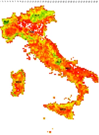
Figure 1 represents the number of habitats of Com-munity interest that are in each cell of the Italian
terri-tory, divided according to the biogeographic areas de-fined by the EU. The number of habitats present with an higher frequency in cells is 4 (observed in 5.94% of the cells), closely followed by the cells with 9 habitats (5.88%); just over 2% of the cells home to more than 30 habitats and only 0.08% reaches the maximum of 39 habitats. Finally, the 2.62% of the total cells has not inside any of the habitats of the Directive. The figure 2 represents the cumulative percentage frequency of cells that host the same number of habitats of Com-munity interest. The trend of the graphic point out that the increase in the number of habitats is quite homo-geneous up to 16 habitats for the cell: about 75% of the cells has a number of habitats between 1 and 16. The slope of the graph decreases in particular from 20 habitats per cell as only 15% of the cells has a greater number of 20 habitats.
In figure 3 we analyzed only the habitats of priority interest, represented as absolute number (Fig . 3a) or as a percentage of all the habitats of Community inter-est (Fig . 3b). 9% of the cells not even host a priority habitat, 20% of the cells is home to one and about 70% of the cells has a number of priority habitats between
Fig. 1 - Number of habitats of Community interest that are in each cell of 10x10 km of the Italian territory. ALP : Alpine biogeographical region, CON: Continental biogeographical region, MED: Mediterranean biogeographical region. In the-se analyzes we included also marine habitats.
1 and 4.
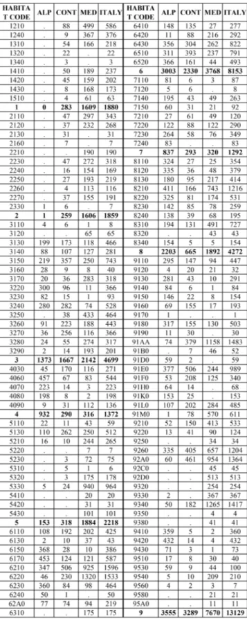
Table 1 shows the data referred to all habitats togeth-er and separately for each macrocategory. Since the total number of cells (second row in the table) repre-sents the sum of the cells where we can find each habi-tat belonging to the same macrocategory, a cell that houses more of a habitat of the same macrocategory is counted more times. This value therefore depends on both the distribution of individual habitat that the number of habitats included in the macrocategory (first row). The number of cells with at least a habitat of a macrocategory (third row) expresses the general dis-tribution of habitats with similar physiognomy (same
macrocategory). In the fourth row of table 1 this value is expressed as a percentage of the total number of cells of the entire Italian territory or in each biogeo-graphic region.
More than 97% of the cells that represent the Ital-ian territory is occupied by at least one habitat of the Directive. A separate analysis of habitats included in each macrocategory shows that in Italy the forests (macrocategory 9) are represented by the largest num-ber of habitats and distribution cells. 91.1% of the Italian territory cells are occupied by forest habitats: this percentage rises to 96.6% in the Alpine region and down to 87.4% in the Continental, where it is still the highest percentage compared to the other macrocate-gories. Grassland habitats of macrocategory 6 "Natural and semi-natural grassland formations" have an high coverage too, covering 83.7% of the Italian cells. At the national level the macrocategories with the low-est percentage of coverage are those related to coastal environments: the 2 "Coastal, sand dunes and inland dunes" with 13.0% and 1 "Coastal and halophytic hab-itats" with 21.2%.
The grassland habitats (macrocategory 6) have the highest average number of distribution cells for each type of habitat (544): this high average value primar-ily involves the priority habitats 6210(*) "Semi-natu-ral dry grasslands and scrubland facies on calcareous Fig. 2 - Cumulative percentage frequency of cells of 10x10
km with the same number of habitats.
Fig. 3 - a) Number of habitats of priority interest that are in each cell of 10x10 km of the Italian territory. b) Percentage of habitats of priority interest compared with all the habitats of Community interest that are in each cell. ALP : Alpine biogeographical region, CON: Continental biogeographical region, MED: Mediterranean biogeographical region. In these analyzes we included also marine habitats.
substrates (Festuco-Brometalia) (*important orchid sites)" and 6220* "Pseudo-steppe with grasses and annuals of the Thero-Brachypodietea", respectively present in 1,596 and 1,533 cells. The average number of cells of forest habitats is lower than that of grass-land habitats, while having the woods a greater total number of cells. In fact, the macrocategory 9 includes both habitats well distributed throughout the national territory (as 91AA* "Eastern white oak woods" or 9340 "Quercus ilex and Quercus rotundifolia forests", respectively present in 1,483 and 1,417 cells), than much more localized habitats that occupy only one or a few cells (for example the habitat 9170
"Galio-Carpinetum oak- hornbeam forests" is represented by
a single cell and 9350 "Quercus macrolepis forests" has only 4 cells). Within each macrocategory, in fact, the number of cells of each habitat can also change very significantly depending on the biogeographical characteristics and specific ecological requirements of the individual habitats (see table 2).
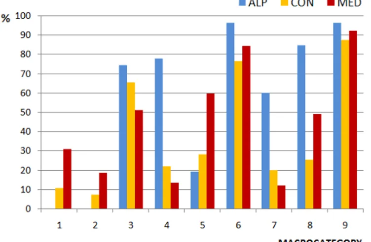
The percent coverage of individual macrocategories changes greatly between the different biogeographi-cal regions (Fig. 4). Leaving out forest and grasslands habitats, where the relative percentages of coverage Tab. 1 - Number of habitats, the total number of cells, num-ber and percentage of cells with at least one habitat of the total cells of the whole Italian territory and for each bio-geographical region, calculated separately for each macro-category and all habitats. In these analyzes we included also marine habitats. Macrocategory 1= Coastal and halo-phytic habitats; 2= Coastal, sand dunes and inland dunes; 3= Freshwater habitats; 4= Temperate heath and scrub; 5= Scleophyllous scrub (matorral); 6= Natural and semi-natural grassland formations; 7= Raised bogs and mires and fens; 8= Rocky habitats and caves; 9= Forests .
Tab. 2 - Number of distribution cells for each habitat in each biogeographic region.
are higher in all biogeographical regions, coverage of other macrocategories is different in each region. In the Alpine region the percentage of cells occupied
by habitats of the macrocategory 8 "Rocky habitats and caves" rises to nearly 85% (this presence at the national level is 48%). Even temperate shrublands of the macrocategory 4 and habitats of inland waters of the macrocategory 3 have an high percent coverage in the Alpine region. The bogs of the macrocategory 7 go up to 60% against a national coverage of 21.6%. The macrocategories 1 and 2, more typically coastal, have instead markedly reduced percentage covers or almost null. In the Continental region, in 7% of the cells are not found habitat. Under these conditions increases the relative importance of freshwater habitats of the mac-rocategory 3, because of the low representativeness of the other habitats, including forests and grasslands. In the Mediterranean region, however, the percentage of macrocategory 5 "Sclerophyllous scrub (matorral)" is higher, as well as that of coastal habitats and dune (macrocategories 1 and 2). On the contrary, the macro-category with a smaller number of cells in the Mediter-ranean region is that of the bogs (7).
Though in absolute terms the number of cells con-taining at least one of the habitats of the Directive is greater in the Mediterranean region (1999, see Table 1), having this region a larger area than the others, as a percentage of the total number of cells in each biogeo-graphical region in the Mediterranean one habitats are less represented than what is observed in the Alpine region, where 100% of the cells home to at least one habitat (Fig. 5). The Alpine biogeographical region, in fact, while covering a smaller area than the other two regions, it is mostly occupied by the mountain areas where human activities have less impact because of the topography of the area. In the Continental region the percentage goes down to 93%, this region includ-ing the Po Valley where industrial activities and inten-sive farming have virtually eliminated almost entirely natural vegetation strips.
If we consider only the cells containing habitats that
are present within the Natura 2000 network (SCI and SPA areas), in Italy they account for more of the 80% (80.9%) of all the cells containing habitats that are pre-sent on the Italian territory (Tab. 3). 19.1% of the cells with habitats of the Directive (649 cells, to be exact) is then located outside the Natura 2000 network.
As for the conservation status of habitats, Figure 6 shows that the habitats present within the Alpine re-gion are in a worst global conservation status than in other regions: 75% of the habitats within the Alpine region is in an unfavourable conservation status ( unfavourable-inadequate = U1 or unfavourable-bad = U2). Even the habitats of the Continental region are not in an excellent conservation status, with 70% in unfavourable conservation status, while in the Medi-terranean the percentage of habitats with unfavorable
Fig. 4 - Percentage of cells with at least one habitat of each macrocategory for each biogeographical region.
Fig. 5 - Percentage of cells with at least one habitat of the total cells of each biogeographic region and all over the Ita-lian territory.
Tab. 3 - Number and percentage of cells containing ha-bitats inside and outside the Natura 2000 network.
Fig. 6 - Percentage of habitats with different state of global con-servation status for each biogeographical region. FV= favoura-ble; U1= unfavourable-inadequate; F2= unfavourable-bad.
conservation status falls further to 59%.
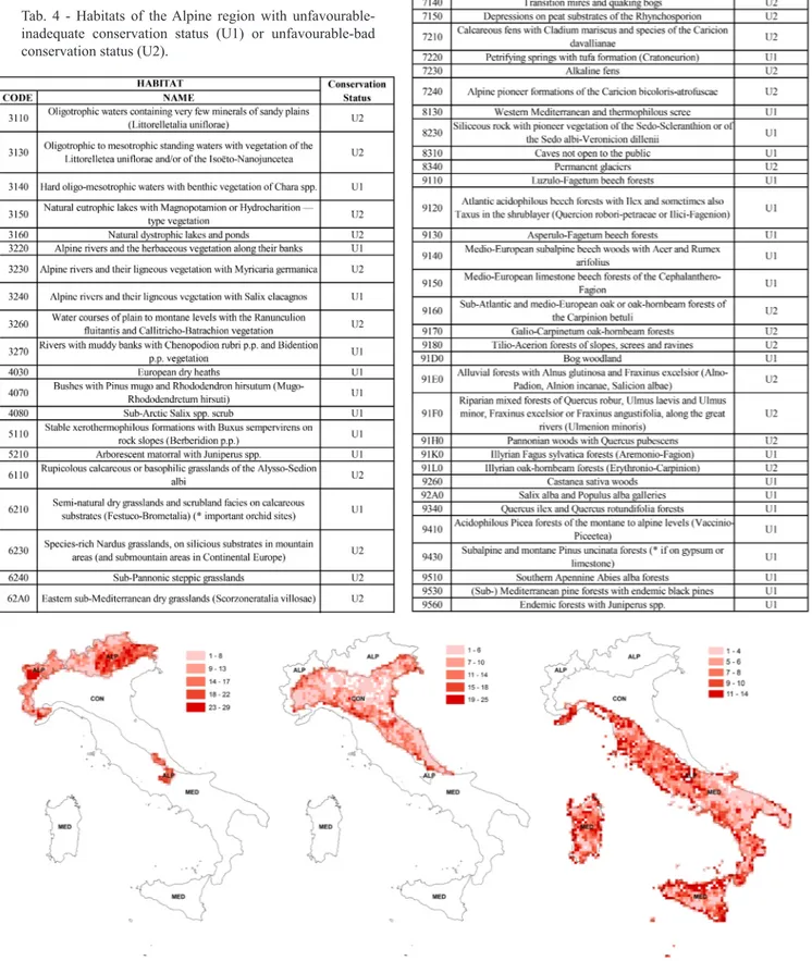
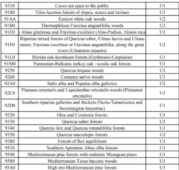
The areas of each biogeographic region with a greater number of habitats in unfavourable conservation status (U1 or U2) are shown in Fig. 7. Tables 4, 5 and 6 set out a list of these habitats for each biogeographic region.
Fig. 7 - Number of habitats with Unfavorable Conservation Status (U1 or U2) in each cell of each biogeographical region. Tab. 4 - Habitats of the Alpine region with
unfavourable-inadequate conservation status (U1) or unfavourable-bad conservation status (U2).
Tab. 5 - Habitats of the Continental region with unfavoura-ble-inadequate conservation status (U1) or unfavourable-bad conservation status (U2).
Tab. 6 - Habitats of the Mediterranean region with unfavou-rable-inadequate conservation status (U1) or unfavourable-bad conservation status (U2).
Table 7 makes it possible to detect that in the Alpine region habitats that are found with a higher percentage in an unfavorable conservation status are those of the macrocategory 7 (raised bogs and mires and fens), fol-lowed by freshwater habitats (macrocategory 3). In the Continental and Mediterranean regions, however, the habitats most affected by the human impact are those of coastal dunes (macrocategory 2): in the Mediter-ranean region they are in unfavourable conservation status even in 100% of cases.
Discussion
From the analysis of the distribution of all habitats on the Italian territory we can observe that mountain areas (western Alps, Eastern Alps, Apuan Alps, Cen-tral Apennines) are the areas where there is the larg-est number of habitats. In these areas, in fact, the individual cells include within them considerable al-titudinal variations which determine also very differ-ent environmdiffer-ental conditions, especially in relation to bioclimatic variations. Even coastal areas are home to a great number of habitats, especially in regions where naturalness of coastal areas has been more preserved (such as Sardinia, Sicily, Tuscany and part of North Adriatic coast). Close to the coast line, in fact, envi-ronmental conditions vary within a few meters as one moves away from the sea, resulting in the succession of different habitats, each other in catenal connection, expression of a significant concentration of biodiver-sity. The cells with no habitats are mainly located in lowland areas, especially in the Po Valley and the “Tavoliere” in Apulia, heavily exploited by intensive agricultural activities and, especially in the Po Valley, by a strong urban and infrastructure development. The
cells that do not host any habitat, however, represent only 2.6%, while those that have more than 20 habitats are about 15% of the total. These data show, therefore, that there is a widespread naturalness on the Italian ter-ritory: although most of the peninsula is characterized by hilly morphologies in which the human presence is consistent and agricultural and urbanized areas are uniformly distributed, the habitats of conservation im-portance are well represented. These data highlight, at least at the used survey scale, an interpenetration of the natural elements in anthropic landscape that makes Italy a country with high biodiversity.
The distribution of habitats with priority importance is similar to that observed for habitats of Communi-ty importance. The areas that are home to the largest number of priority habitats are the Valle d'Aosta and the central Apennines in Abruzzo, where even the to-tal number of habitats is greater. However, consider-ing the proportion of priority habitats of all habitats of Community interest may be observed that the most exclusive areas for priority habitats are coastal, mainly thanks to the presence of habitat 1120* "Posidonia beds (Posidonion oceanicae)" that is 100% of all EU habitats. The high percentage of priority habitats in some cells located in the Po Valley is due instead to the only presence of the habitat 91E0* "Alluvial forests with Alnus glutinosa and Fraxinus excelsior
(Alno-Pa-dion, Alnion incanae, Salicion albae)", whose subtype
44.13 “White willow gallery forests (Salicion albae)” has in the Po valley its southern distribution limit in Italy (Biondi et al., 2009).
The analysis of the distribution of macrocategories shows that in Italy the habitats with greater percent-age of distribution are the forests and the grasslands. Even shrubby habitats are well represented, although their percentage coverage is separated into the two macrocategories (4 and 5); the Habitats Directive, in fact, distinguishes temperate shrublands from Medi-terranean ones, more due to ecological reasons than to physiognomic reasons. The observed good balance between coverage of grassland habitats, shrubs and forests leads to good values of biodiversity in the Ital-ian territory. Unfortunately, in recent years the cover of shrub and tree vegetation is increasing at the expense Tab. 7 - Percentage of habitats with unfavorable conservation status for each macrocategory in each biogeographical region.
of grasslands due to the abandonment of traditional agro-forestry-pastoral practices and the establishment of the evolutionary dynamics of the vegetation (Bi-ondi, 2008; Bi(Bi-ondi, 2009; Galdenzi et al., 2012). The largest area occupied by grassland, shrub and forest habitats is due to ecological and structural character-istics of these habitats, generally less related to small environments as are coastal habitats of macrocatego-ries 1 and 2, and those related to wet environments (macrocategories 3 and 7).
Due to the geomorphological features of the terri-tory, in the Alpine region increases the coverage of the rocky habitats, strongly linked to mountain areas, as well as that of temperate shrubs habitats related to in-land waters and peat bogs, thus underlining the strong link of these environments to Alpine region. The rug-ged morphology of the Alpine region caused a less ex-ploitation of this territory by human activities and this is reflected in the presence of at least one habitat of the Directive to all the cells in the region. However, these habitats are often not in a good conservation status. Especially wet habitats of the macrocategories 7 (peat bogs) and 3 (inland waters) are impacted by anthropo-genic and climatic change.
The Continental biogeographical region suffered most from the human impact: the low-hill and plain areas have strongly been affected by consumption of soil by human activities, resulting in an overall low representativeness of the habitats of all the macrocat-egories, including forest and grassland. The habitats of the Continental region, as well as being under-represented, they are in an unfavourable conservation status in 70% of cases, a percentage that rises to 80% for coastal dune habitats. In the Mediterranean region, although it has also been heavily exploited by human activities, instead there is a widespread presence of natural habitats even favoured from traditional agro-forestry-pastoral activities, such as grassland. The con-servation status of these habitats is therefore typically better than in the Continental region, even if 100% of dune coastal habitats are in an unfavourable conser-vation status. In the Mediterranean region the major human impacts are in fact due to the tourist-beach ac-tivities. The rocky habitats are in an unfavorable con-servation status in a lesser percentage in all the three biogeographic regions: in fact, they are in general less affected by the impact of human activities.
According to the European biogeographic classifica-tion, in Italy Alpine, Continental and Mediterranean biogeographical regions extend respectively for 18%, 29%, and 53% of the territory. The comparison with the bioclimatic map of Italy shows that about 45% of the Continental region and 19% of the Mediterranean region fall within the Temperate macrobioclimate sub-Mediterranean variant. Consequently, the attribution of a habitat to a certain biogeographic region made on
the basis of the Interpretation Manual of European Un-ion Habitats - EUR28 (European CommissUn-ion, 2013) is more administrative than scientific and, therefore, not fully comprehensive and adequate (Biondi et al ., 2015).
Finally, as regards the distribution of habitats within the SCI and SPA areas, a large proportion (over 80%) of the cells containing habitat is located in Natura 2000. It would appear that the Natura 2000 network in Italy, while occupying only 18% of the territory (Rosati et
al., 2007), is able to cover the distribution of habitats
adequately enough. This assessment, however, must necessarily takes account of the methodology which considers cells of 100 km2 that can host habitats also only on a small portion of their surface. In addition, it must be considered that in the absence of detailed information, the reconstruction of the data outside Natura 2000 sites can not be complete as within sites.
Concluding remarks
The investigations carried out for completing the re-porting format required by Directive 92/43/EEC have been found very useful to have guidance on how bio-diversity is distributed on the Italian territory and to assess its conservation status. The survey scale used is appropriate at European level to compare the distri-bution and amount of habitats present in the different nations of the European Community. Despite the cells used in the distribution maps covering a surface of 100 km2 and are therefore not very useful to precisely lo-cate habitats, they can still provide valuable informa-tion at the nainforma-tional level to identify the geographical areas of the Italian territory that are more rich of habi-tats (hot spot of biodiversity) and at the same time to locate areas with less naturalness.
The data of the reporting format offer a snapshot of the Italian territory characterized by a biodiversity suf-ficiently distributed throughout the territory. It should however be noted that the number of priority habitats in Annex I of the Directive must be increased, by as-signing the rank of priority habitats on a regional ba-sis taking into account the different conditions arising from the reports, and then by local monitoring. At the same time it is important to consider also many habi-tats that currently are not in the Annex I of the Direc-tive even if they are very important on the national level, as proposed by the Italian Botanical Society. The Italian Ministry can propose to insert these habitats in Annex I of the Directive when the European Union will reopen the term for variations (Biondi, 2013).
The analysis of the conservation status of habitats differentiated by biogeographic region has the advan-tage of allowing a separate assessment of the same habitat that may be subject to different human impacts in the different biogeographical contexts. The internal
biodiversity of a single habitat can vary a lot between different biogeographical regions and often in the bor-der areas between two different regions is observed increased biodiversity due to the presence of species from different biogeographic contexts that in border areas are mixed. This is, for example, the case of the vegetation of the coastal dunes in the North Adriatic, on the border between the Continental and the Alpine region, where it is enhanced by species with alpine distribution (Sburlino et al., 2013). Unfortunately, at present the Habitats Directive does not expect that the allocation of priorities to a habitat is differentiated for biogeographical region or even for the different sub-types of the habitat. It would be desirable for this dif-ferentiation in subsequent updates of Annex I of the Directive (Biondi et al., 2014).
The large amount of information collected during the monitoring of habitats in Italy for the third report is an important source of georeferenced data for the first time related to the whole Italian territory. We can start from these data for future monitoring but to update the database it is desirable to have continuous information from experts activated by Italian Regions and Autono-mous Provinces that are responsible of environmental resources by delegation from the State (Legislative Decree 3 April 2006, n. 152). The need to have the opinion of the expert, often observed during the col-lection of data, depended both from vagueness and subjectivity of the method provided by the European Community that the lack of quality and homogeneity of available data. What has been achieved so far is only the starting point of an ongoing process of European biodiversity conservation. It is therefore necessary to stress not only the need for long-term monitoring pro-grams, already expected by the Community directives, but also to start appropriate monitoring programs at lo-cal, regional or sub-regional scale with more analytical details and adequate cartographic representations so that administrators can consciously manage the focal points of their territories.
We also need to highlight the lack, in many secto-rial experts, of a proper understanding of the concept of habitat which is the true innovation in the field of conservation biology introduced by Directive 92/43/ ECC: not by chance this Directive is generically re-ferred to as the Habitats Directive. It is in fact through the conservation and proper management of habitats that it is possible the effective maintenance of most of the species in the ecosystems in which they live (in situ conservation). In research aimed at preservation of the biodiversity, the European Community policy should therefore be more focused to enhance the cog-nitive logical process of integration of the species in their environment. Such knowledge should indeed be the basis for the realization of the management plans for Natura 2000 sites (article 6 Directive 92/43/EEC)
still being carried out in Italy.
On the plains and in the low hills of Italy, as in all the European Union, intensive agriculture causes the big change and extreme reduction of "agricultural ecosys-tems". Nearly half (48%) of the bird species associated with agricultural habitats are in a favourable conser-vation status, and 8% are unfavourable but improved, while 28% are unfavourable and deteriorated. The threats and pressures most frequently reported as con-siderable for agricultural habitats and species include both intensification and abandonment. (European En-vironment Agency, 2015). As for flora and vegetation, the practice of weeding, conducted also in the residual areas as well as directly in the fields, produces enor-mous effects of alteration in agro-ecosystems result-ing in soil erosion and groundwater pollution (Taffe-tani et al, 2003). An important monitoring system of agro-ecosystems was made by Taffetani & Rismondo (2009) and is based on the phytosociological and syn-dinamical analysis of communities living in different landescape area (Taffetani et al., 2011; Giupponi et al., 2013).
Finally, a fundamental aspect to keep in mind, because it will impact more strongly in the near future, on the conservation of habitats and species, is linked to global warming. The effects of climate change are leading to a transformation of habitats already detectable across species. In fact, biologists are finding evidence of this transformation across a wide range of taxonomic and functional groups. Species are responding to climate change by altering their phenology and geographical distributions (Hickling et al. 2006; Lenoir et al. 2008). Considering the rapidity of the changes caused by global warming, it is necessary to create conditions so that these species are not forced to emigrate or to be-come extinct, rebuilding secondary habitats of refuge. Araújo et al. (2011) show that nationally designated protected areas would preserve species better than un-protected areas, probably because they tend to occur in mountains, which act as climate refugia. The species of the Natura 2000 network living in the plains next to the coasts are the most vulnerable as they are included in the few surviving areas surrounded by agricultural activities and buildings and, at the same time, are more exposed to the consequences of climate change (Pe-terson 2003; Loarie et al. 2009; Biondi et al., 2012c). The Italian coasts are particularly vulnerable to the ef-fects of global warming. A predictive model relating the effects of the climate change on the Italian coasts (Prisco et al. 2013) foretells that without proper man-agement the habitats of the fixed and the mobile dunes may disappear in the short term. In Italy, despite the strong alteration that habitats suffered, a high number of coastal plant communities still occurs. Therefore, it is necessary to carefull manage these habitats and we need to carry out a recovery strategy that would
allow the preservation of ecosystems and thus the improvement of natural areas along the Italian coasts (Biondi et al. 2014). This is definitely the priority of the protection of habitats for Italy. The significant loss of biodiversity in coastal areas is also highlighted by diachronic analyzes (Brachetti & Accounts 2014; Del Vecchio et al. 2015). The conservation of biodiversity requires approaches as the reclassification of existing conservation areas (Fuller et al. 2010) and the des-ignation of new areas, as well as the implementation of mechanisms for the integrated management of the countryside to facilitate movement of species between conservation areas (Biondi et al. 2012b).
Acknowledgments
The Authors would like to thank Eleonora Bianchi (Ministry of Environment and Territory and Preserva-tion of the Sea, Rome, Italy) for the creaPreserva-tion of the report. Thank also to the botanical colleagues who pro-vided useful information at regional and local level for the preparation of the report.
References
Angelini P., Augello R., Bianco P.M., Gennaio R., La Ghezza V., Lavarra P., Marrese M., Papallo O., Per-rino V.M., Sani R. & Stelluti M., 2012. Carta degli habitat della Regione Puglia per il sistema informa-tivo di Carta della Natura alla scala 1:50.000. ISPRA - Arpa Puglia.
Araújo M.B., Alagador D., Cabeza M., Nogués-Bravo D. & Thuiller W. 2011. Climate change threatens Eu-ropean conservation areas. Ecology Letters 14: 484-492.
Bianco P.M., Laureti L., Papallo O. & Perfetti D., 2012. Carta degli habitat della Regione Umbria per il sistema informativo di Carta della Natura alla scala 1:50,000. ISPRA
Biondi E., 2008. Natura e paesaggi del territorio anco-netano. In: Lasen C. (Ed.), Tesori naturalistici. Alla scoperta dei paesaggi e della biodiversità, dalla mon-tagna al mare, nelle provincie di Belluno, Vicenza, Verona, Mantova e Ancona: 383-466. Fondazione Cariverona.
Biondi E., 2009. Habitat terrestri e d’acqua dolce: vege-tazione. In: F. Stoch (Ed.), Gli habitat italiani espres-sione di biodiversità. Quaderni Habitat 24: 47-87. Ministero dell’Ambiente e della Tutela del Territorio e del Mare e Museo Friulano di Storia Naturale, Arti Grafiche Friulane, Udine
Biondi E., 2013. The “Italian Interpretation Manual of the 92/43/EEC Directive Habitats” and the prospects for phytosociology in the field of environmental su-stainability. Archivio Geobotanico 14 (1-2):1-16. Biondi E. & Blasi C., 2009 (Eds.). Italian interpretation
Manual of the habitats (92/43/EEC Directive). Mini-stero dell’Ambiente e della Tutela del Territorio e del Mare. http://vnr.unipg.it/habitat/.
Biondi E., Allegrezza M., Casavecchia S., Galdenzi D., Gasparri R., Pesaresi S., Soriano P., Tesei G. & Blasi C., 2015. New insight on Mediterranean and sub-Me-diterranean syntaxa included in the Vegetation Pro-drome of Italy. Fl. Medit. 25 (Special Issue): 77-102. 2015. ISSN: 1120-4052 printed, 2240-4538 online. Biondi E., Burrascano S., Casavecchia S., Copiz R., Del
Vico E., Galdenzi D., Gigante D., Lasen C., Spampi-nato G., Venanzoni R., Zivkovic L. & Blasi C., 2012a. Diagnosis and syntaxonomic interpretation of Annex I Habitats (Dir. 92/43/EEC) in Italy at the alliance le-vel. Plant Sociology 49 (1): 5-37.
Biondi E., Casavecchia S., Pesaresi S., 2009. Direttiva habitat e conservazione della biodiversità forestale. Atti del Terzo Congresso Nazionale di Selvicoltura per il miglioramento e la conservazione dei boschi italiani (Taormina, 16-19 ottobre 2008), Vol. I: 71-78. Accademia Italiana di Scienze Forestali, Firenze. Biondi E., Casavecchia S., Pesaresi S. & Zivkovic L.,
2012b. Natura 2000 and the Pan-European Ecologi-cal Network: a new methodology for data integration. Biodivers. Conserv. 21: 1741-1754. DOI 10.1007/ s10531-012-0273-7
Biondi E., Casaveccia S. & Pesaresi S., 2012c. Nitro-philous and ruderal species as indicators of climate change. Case study from the Italian Adriatic coast. Plant Biosystems 46 (1): 134-142.
Biondi E., Catorci A., Pandolfi M., Casavecchia S., Pe-saresi S., Galassi S., Pinzi M., Vitanzi A., Angelini E., Bianchelli M., Cesaretti S., Foglia M., Gatti R., Mo-relli F., Paradisi L., Ventrone F. & Zabaglia C., 2007. Il Progetto di “Rete Ecologica della Regione Marche” (REM): per il monitoraggio e la gestione dei siti Na-tura 2000 e l’organizzazione in rete delle aree di mag-giore naturalità. Fitosociologia 44 (2) Suppl. 1: 89-93. Biondi E., Lasen C., Spampinato G., Zivkovic L. & An-gelini P., 2014. Habitat. In: Genovesi P., AnAn-gelini P., Bianchi E., Dupré E., Ercole S., Giacanelli V., Ronchi F. & Stoch F. (Eds.), Specie e habitat di interesse co-munitario in Italia: distribuzione, stato di conserva-zione e trend. ISPRA, Serie Rapporti 194/2014. Biondi E., Zivkovic L., Sburlino G., Piccoli F.,
Pellizza-ri M., Bacchetta G., 2009. 91E0*: Foreste alluvionali di Alnus glutinosa e Fraxinus excelsior (Alno-Padion,
Alnion incanae, Salicion albae). In: Biondi E. & Blasi
C., 2009 (Eds.), Italian interpretation Manual of the habitats (92/43/EEC Directive). Ministero dell’Am-biente e della Tutela del Territorio e del Mare. http:// vnr.unipg.it/habitat/.
Blasi C. (Ed.), 2010. La Vegetazione d'Italia (con Carta delle Serie d'Italia): 538 pp. Palombi & Partner S.r.l. Roma.
threate-ned plants in the “Sentina Natural Reserve” (Marche, Italy). Plant Sociology 51(2) Suppl. 1: 39-46. Brentan D., Burbello A., Avanzi E., Gasparini S.,
Lau-reti L. & Bianco P.M., 2008. Carta degli habitat del-la regione Veneto per il sistema informativo di Carta della Natura alla scala 1:50.000. ISPRA - Arpa Vene-to. http://www.isprambiente.gov.it/
Camarda I., Carta L., Brunu A., Brundu G. , Laureti L., Angelini P. & Bagnaia R., 2011. Carta degli habitat della Regione Sardegna per il sistema informativo di Carta della Natura alla scala 1:50,000. Dipartimen-to di Scienze Botaniche Ecologiche e Geologiche dell'Università degli Studi di Sassari -ISPRA - Regio-ne Sardegna.
Casella L., Agrillo E., Bianco P.M., Cardillo A., Car-bone M., Cattena C., Laureti L., Lugari A. & Spada F., 2008. Carta degli habitat della Regione Lazio per il sistema informativo di Carta della Natura alla sca-la 1:50,000. ISPRA - Università degli Studi di Roma “La Sapienza” - Regione Lazio
Catorci A., Biondi E., Casavecchia S., Pesaresi S., Vi-tanzi A., Foglia A., Galassi S., Pinzi M., Angelini E., Bianchelli M., Ventrone F., Cesaretti S. & Gatti R., 2007. La Carta della vegetazione e degli elementi di paesaggio vegetale delle Marche (scala 1:50,000) per la progettazione e la gestione della rete ecologica re-gionale. Fitosociologia 44 (2) Suppl. 1: 115-118. Del Vecchio S., Prisco I., Acosta A.T.R. & Stanisci A.
2015. Changes in plant species composition of coa-stal dune habitats over a 20-year period. AoB Plants 7: plv018–plv018.
European Commission, 2006. Assessment, monitoring and reporting under Article 17 of the Habitats Direc-tive: Explanatory Notes & Guidelines. Final Draft October 2006.
European Commission, 2011. Assessment and reporting under Article 17 of the Habitats Directiva. Reporting Formats for the period 2007-2012. May 2011
European Commission, 2013. Interpretation Manual of European Union Habitats - EUR 28. April 2013 European Environment Agency, 2015. State of nature
in the EU. Results from reporting under the nature di-rectives 2007-2012. EEA Technical report No 2/2015. European Topic Centre on Biological Diversity, 2009.
Data completeness, quality and coherence. Unpubli-shed paper available at http://biodiversity.eionet.euro-pa.eu/article17
Evans D. & Arvela M., 2011. Assessment and reporting under Article 17 of the Habitats Directive Explanato-ry Notes & Guidelines for the period 2007-2012. Fi-nal draft April 2011. European Topic Center on Bio-logical Diversity. http://bd.eionet.europa.eu/article17/ reference_portal
Fuller R.A., Mc Donald-Madden E., Wilson K.A., Carwardine J., Grantham H.S., Watson J.E.M., Klein C.J., Green D.C. & Possingham H.P., 2010.
Repla-cing underperforming protected areas achieves better conservation outcomes. Nature 466: 365-367. Galdenzi D., Pesaresi S., Casavecchia S., Zivkovic L. &
Biondi E., 2012. The phytosociological and syndyna-mical mapping for the identification of High Nature Value farmaland. Plant Sociology 49 (2): 59-69. Giupponi L., Corti C., Manfredi P. & Cassinari C.,
2013. Application of the floristic-vegetational indexes system for the evaluation of the environmental quali-ty of a semi-natural area of the Po Valley (Piacenza, Italy). Plant Sociology 50 (2): 47-56.
Hickling R., Roy D.B., Hill J.K., Fox R. & Thomas C.D., 2006. The distributions of a wide range of ta-xonomic groups are expanding polewards. Global Change Biology 12 (3): 450-455.
ISPRA, 2005. Dati del sistema informativo di Carta del-la Natura aldel-la scadel-la 1:50,000.
ISPRA, 2009. Il progetto Carta della Natura. Linee guida per la cartografia e la valutazione degli habitat alla scala 1:50,000. MLG 48/2009. SystemCart S.r.l., Roma.
ISPRA, 2011. Dati del sistema informativo di Carta del-la Natura aldel-la scadel-la 1:50,000
Lenoir J., Gégout J.C., Marquet P.A., de Ruffray P. & Brisse H., 2008. A significant upward shift in plant species optimum elevation during the 20th century. Science 320 (5884): 1768-1771.
Loarie S.R., Duffy P.B., Hamilton H., Asner G.P., Field C.B. & Ackerly D.D., 2009. The velocity of climate change. Nature 462: 1052-1055.
Ministero dell'Ambiente e della Tutela del Territorio e del Mare-Direzione per la Protezione della Natu-ra, 2008. Attuazione della Direttiva Habitat e stato di conservazione di habitat e specie in Italia. Rome. http://www.minambiente.it/sites/default/files/archi- vio/biblioteca/protezione_natura/attuazione_diretti-va_Habitat.pdf
Morra di Cella U., Cremonese E., Pari E., Siniscalco C., Amadei M. & Angelini P., 2008. Carta degli habitat della Regione Valle d'Aosta per il sistema informati-vo di Carta della Natura alla scala 1:50.000. ISPRA - ARPA Valle d'Aosta - Dipartimento Biologia Vegetale Università degli studi di Torino. http://www.ispram-biente.gov.it/
Oriolo G., Dragan M., Fernetti M., Francescato C., Tomasella M. & Giorgi R., 2007. Carta degli habi-tat della regione Friuli Venezia Giulia per il sistema informativo di Carta della Natura alla scala 1:50,000. ISPRA-Regione Friuli Venezia Giulia. http://www. isprambiente.gov.it/
Papini F., Gianguzzi L., Brullo S., Bianco P. M. & Ange-lini P., 2006. Carta degli habitat della Regione Sicilia per il sistema informativo di Carta della Natura alla scala 1:50,000. Dipartimento di Scienze Botaniche dell'Università degli Studi di Palermo - Dipartimento di Botanica dell'Università degli Studi di Catania
-Re-gione Sicilia – ISPRA
Peterson A.T., 2003. Predicting the geography of spe-cies’ invasions via ecological niche modeling. The Quarterly Review of Biology 78 (4): 419-433. Prisco I., Carboni M. & Acosta A.T.R., 2013. The Fate
of Threatened Coastal Dune Habitats in Italy under Climate Change Scenarios. PLoS One 8 (7): e68850. Rosati L., Marignani M. & Blasi C., 2007. Vegetazione
Potenziale e Gap analysis della Rete Natura 2000 in Italia. Fitosociologia 44 (2) Suppl. 1: 61-65
Sburlino G., Buffa G., Filesi L., Gamper U. & Ghirelli L., 2013. Phytocoenotic diversity of the N-Adriatic coastal sand dunes - The herbaceous communities of the fixed dunes and the vegetation of the interdunal wetlands. Plant Sociology 50 (2): 57-77.
Sipkova Z., Balzer S., Evans D. & Ssymank A., 2010.
Assessing the conservation status of European Union habitats-Results of the Community Report with a case study of the German National Report. Ann. Bot. 1: 19-37.
Taffetani F., Giorgini A. & Riolo P., 2003. Role and the ecology of the bands of spontaneous vegetation in the agroecosystems-Landscape Management for Functio-nal Biodiversity. IOBC wprs Bulletin 26 (4): 161-166. Taffetani F. & Rismondo M., 2009. Bioindicators
sy-stem for the evalutation of the environment quality of agro-ecosystems. Fitosociologia 46 (2): 3-22. Taffetani F., Rismondo M. & Lancioni A., 2011.
En-vironmental Evaluation and Monitoring of Agro-Ecosystems Biodiversity. In: Grillo O. & Venora G. (Eds.), Ecosystems Biodiversity: 333-370. InTech.