Christina Matika
Born in Thessaloniki (Greece) in 1986, has studied Architecture at University of Thessaly (2004-2010) and Urban planning - Metropo-lisation at ENSA de Paris la Villette (2010-2012). Her practice experience varies from participation in the Research Unit of Urban & Regional Innovation, the creative clusters’ workshop to the Organization of Planning & Environmental Protection of Thessaloniki. Furthermore, she is interested participating in research programs, international confe-rences, and architectural competitions.
“Il Corridoio del Fiume Yonne”
Una Rete di Città: il Fiume come un Itinerario Turistico
Spazio di vita per molte specie animali e vegetali, il sistema del fiume e dei suoi affluenti rappresenta una ricchezza fondamentale anche per gli insediamenti umani nella val-le dello Yonne, Francia. Nel caso di studio che presento val-le principali questioni discusse sono: 1. Come l’infrastruttura si relaziona al paesaggio della Yonne. 2. Quali potrebbero essere le possibilità e le potenzialità per il trattamento di questa risorsa locale. 3. Come le autorità locali potrebbe-ro avviare un ppotrebbe-rogetto di sfruttamento e valorizzazione di questa regione dell’acqua. 4. Quali interventi potrebbero rafforzare il dinamismo della regione. 5. Come articolare la discontinuit’ dei nuclei urbani intorno al fiume Yonne in modo sostenibile e tenendo conto della minaccia di inonda-zioni. 6. Ultimo ma non meno importante, come è possibile affrontare il problema della discontinuità tra le rive del fiu-me e lo spazio urbano, recuperando le banchine.
“Yonne River Corridor”
Network of Yonne Cities: the River as Tourist Route
Long living space for many animal and plant species, the river system and its tributaries represent a principal we-alth, always valid for human settlements in the Yonne val-ley, France. In my case study the major questions raised as starting points are: 1. How the infrastructure is related to the landscape of Yonne. 2. Which could be the possibi-lities and potentiapossibi-lities to treat this local resource. 3. How local authorities could start a project of exploitation and valorization of the water region. 4. Which interventions could enforce the dynamics of the region. 5. How to arti-culate cities in discontinuity around the Yonne river, taking into account the flood threat, but in a sustainable way. 6. And last but not least, how can we face the problem of rupture between the banks of the river and the urban space, regaining the docks.
Parole chiave: Alveo fluviale, infrastrutture di
tra-sporto, Turismo fluviale, Sostenibilità, Riqualifica-zione.
Keywords: River Corridor, Transportation Route,
Tourist Route, River Tourism, Sustainability, Re-qualification
“Yonne River Corridor” Network of Yonne Cities: the River as Tourist Route C. Matika
First of all, the main issue concerns the rea-son why the research choice for the network of Yonne cities has occurred. In general, there are some basic issues considering metropoli-tan regions, such as the urban sprawl, the con-flicts for the localization of large equipments, the localization of Malls in the suburban area, the variety of requests for road infrastructu-res, the localization of the commercialized lei-sure activities, the preservation and valuation of landscapes (urban and rural).
Moreover, I should refer to eight simple direc-tives that play a major role in urban planning intervention: 1. excellent anticipation of flood, 2. valuation of ecologic potentials, 3. increased value of use by recreational opportunities and
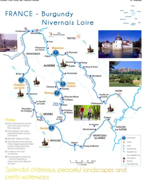
Figure 1 - Map of the Burgun-dy region in France (Bourgo-gne): Nivernais Loire region, the canal of Burgundy and the river Yonne.
“Yonne River Corridor” Network of Yonne Cities: the River as Tourist Route C. Matika
leisure, 4. search for a better life quality that leads to new economic potentials, 5. valuation of its own history in a context of a sustainable development, 6. continuity clearly perceptible of open spaces and sequences of biotopes, 7. recognisable materials and shapes suppor-ting a local identity, 8. a region that manages to exercise its own attractiveness, that makes you want to belong in it, that allows you to find everything that you need for living.
The Network of Yonne cities concerns a project, a dynamic, an everyday occurrence, through the experimentation in Yonne area, the perspectives and the evaluation of the re-sults.
Long living space for many animal and plant
species (fauna & flora), the river system and its tributaries represent a principal wealth, always valid for human settlements in the Yonne valley, France. The charming canal of Nivernais, reputed to be the one of the pret-tiest in France, and its surrounding network of equally pretty waterways – the canal of Bur-gundy (Bourgogne) and the river Yonne – pro-vide access to some of the most beautiful and varied cruising areas of France.
On the edge of the Nivernais Loire region, the gently sloping canal lateral in the Loire fol-lows the course of the river Loire, giving spec-tacular views of the surrounding vineyard-clad hilltops and the river Loire itself.
In my case study these are some of the major
questions raised as starting points:
1. How the infrastructure is related to the landscape of Yonne? How can a territory-infrastructure project around water be managed?
2. Which could be the possibilities and the potentialities to treat this local resource? 3. How local authorities could start a project
of exploitation and valorization of a water region (“un pays d’eau”) and which is their role?
4. Which interventions could enforce the dynamics of the region? The issue of cities as source of life and a project territory. 5. How to articulate cities in discontinuity
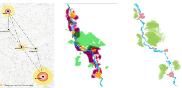
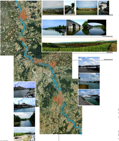
around the Yonne river? Figure 2- Map of cities – poles
of tourist attraction hierarchy in Yonne Area: 1. Auxerre, 2. Sens, 3. Joigny, 4. Migennes, 5. Villeneuve
Figure 3 - Map of land uses in Yonne Area
Figure 4 - Map of flood-prone areas in Yonne Area.
“Yonne River Corridor” Network of Yonne Cities: the River as Tourist Route C. Matika
Objectives:
• The connection of successive settlements in the Yonne area with the river (tributa-ries, ponds, spring / fountain, aqueducts etc).
• The treatment of the meeting of urban / urbanized areas with the river basin. • The articulation of cities in discontinuity
around the water.
• The river as transportation route. • The river tourism.
• The ecological value and development of the river environment – landscape. • The development of recreational and
lei-sure activities consistent with the river basin.
• Taking into account the flood threat, but in a sustainable way.
At first, my research began by exploring the space, with detailed observations of the cities inside the network of Yonne area. Thus, in an attempt to map this network, I visited the city of Sens, Villeneuve, Joigny, Migennes and Au-xerre. So after mapping these five cities and creating their profile, I recorded the city-poles of tourist attraction hierarchy, the land uses and the flood-prone areas in Yonne Area. By collecting important data, I concluded that: • the basin area of the canal of Yonne is
estimated at 10,840 km,
• three quarters of Yonne’s population live in Sens or in Auxerre,
• the identity of every city is fundamentally connected with the element of water, • there are many different types for using
the Yonne river as a route,
• transport infrastructure such as roads, motorways, railway, river water routes (ships, ferries) could be highly developed and
• water life (living next to the water) should be linked more closely with the transport and the river tourism.
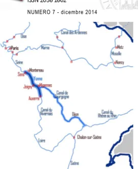
As far as the river tourism in Burgundy (Bou-rgogne) is concerned, the Burgundy region has the chance to own the largest and most important network of waterways in France.
Ri-“Yonne River Corridor” Network of Yonne Cities: the River as Tourist Route C. Matika
ver tourism is for many years the flagship pro-duct of Burgundy tourism. It has gained, year after year, an international reputation, with 8 canals and 4 rivers included in the Burgundy river Area (66 water stops – moorings and 33 marinas – seaports).
At a national level, the good public transpor-tation increases the attractiveness of the area and the development of activity parks. Regar-ding to the waterway network, the Parisian na-vigable network is counting of 700 kilometers, of waterways, whether from the Seine, Mar-ne, Oise, Yonne as the canals of Saint-Martin, Saint-Denis, Ourcq or Loing for example. The basin of Parisian tourist navigation is clo-sely connected to other neighboring French
regions, also with very active river systems, and in relation to neighboring European re-gions, where river tourism is highly develo-ped: Belgium, Germany and the Netherlands. At a local level, the significant proportion of pedestrian traffic could be conserved and en-hanced, while on the other hand, the cycling movement, where the terrain permits, could be developed.
THE CENTRAL BASIN - BURGUNDY (BOURGOGNE)
This basin is connected to the basins of the Sei-ne, East and Saone - Rhone rivers, which al-lows it to have an important role as a crossro-ad. It is structured in three main north-south
axes.
The first takes the canal of Loing, the canal of Briare (one of the oldest waterways) and the lateral canal of Loire to reach, through the ca-nal of Centre, the Saone in Chalon-sur-Saone. The second axis from Montereau-Fault-Yon-ne, takes the canal of YonMontereau-Fault-Yon-ne, the canal of Ni-vernais (considered one of the most beautiful canals in France) and joins the lateral canal in the Loire in Decize. Finally, the third axis from Yonne, in Migennes and takes the Burgundy canal to reach the Saône in Saint-Jean-de-Lo-sne, the largest port/marina in France, with 55 stops and ports located throughout the river system, and 9 dockyards – shipyards.
[Previous page]
Figure 5 - The river tourism in Burgundy (Bourgogne) Figure 6 - Map with moorings and seaports in Burgundy re-gion (Bourgogne) in France. Yellow / water stops – moo-rings. Red / marinas - seaports Figure 7 - Yonne river in France, National level
Figure 8 - Yonne river in Bur-gundy region, Local level
“Yonne River Corridor” Network of Yonne Cities: the River as Tourist Route C. Matika
THE RIVER TOURISM
River tourism covers a very wide range of ac-tivities, including both short walks of a few hours or a day, multi-day river cruises abo-ard hotel – boats (river boat – ships or sail-boats or hotel barges), private river pleasure aboard houseboats or small units of walk, lo-cal sailing (fishing boat, canoe, canoe-kayak, rowing) but also activities performed along the waterway (excursion, hiking, visits to worksi-tes or museums related to the waterway). It is characterized by three basic categories: a. the rental houseboats, b. the river cruise (river boat – ships or sailboats or hotel barges) and c. the tour boats – ferries.
The issue of the regional council is to provide a
comprehensive reflection across the entire re-gion, bringing together these various activities (whether river trips, traveling by cycling along the banks or marine leisure, water or sports) to restore the waterways as an element in the Paris tourist region. River tourism covers a lot of activities on very different practices, whe-ther river pleasure, tourism by cycling along the banks or marine leisure (water sports). Improving the quality of life related to the im-plementation of a stop, at the docks and sho-reline development, generate - in addition to economic benefits, albeit limited, for the local economy - an interesting local revitalization. Given the relatively weak position of the main activities of river tourism - mostly boating trips
- the challenge is to promote the waterway as a place of varied leisure, accessible to all. At this point I should add the conditions that river tourism presupposes. First of all, the development of maritime stops (for sanitary supplies), secondly, guides for sail boaters, a tourist guide mainly for interesting sites and commercial points nearby the network of Yonne cities, the maintenance of banks and locks, and last but not least, networking with footpaths and cycling routes including the towpath, with access in the train station. Furthermore, to enhance touristic character, local people should be involved, a real effort for cooperation of the existing resources and tools, federation projects around a common
“Yonne River Corridor” Network of Yonne Cities: the River as Tourist Route C. Matika
issue (festivities on the riversides, etc) should be organised so as to become the bearer of the identity of the territory.
THE RIVER AS TOURIST ROUTE - THE RIVER CORRIDOR
Yonne is a river in the northern half of Fran-ce, flowing mainly in the west of the Burgun-dy region. It is the largest left tributary of the Seine and it gave its name to the department of Yonne.
There are three ports on the Yonne: Joigny, Villeneuve-sur-Yonne and Auxerre. With Mi-gennes, not far from the river, on the adjacent canals, there are four marinas that constitute the departmental network. These ports are [Previous Page]
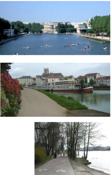
Figure 9 - Marina (Port de plai-sance) in Fontainebleau – Avon Figure 10 - Water and electrici-ty recharging station in the Ri-ver stop of Ferté-sous-Jouarre.
Figure 11 - Rowing in the canal of Villette in Paris
Figure 12 - Marne’s banks in Meaux
Figure 13 - Right bank of Rhône river in Lyon, with a cyclist road, that joins the Park of Miribel-Jonage
“Yonne River Corridor” Network of Yonne Cities: the River as Tourist Route C. Matika
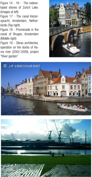
Figure 14 - 16 - The redeve-loped shores of Zurich Lake. (Images at left)
Figure 17 - The canal Keizer-sgracht, Amsterdam, Nether-lands (Top right)
Figure 18 - Promenade in the canal of Bruges, Amsterdam (Middle right)
Figure 19 - Obras architectes, operation on the docks of Ha-vre river (2002-2009), project “River garden”
places where boats can reside throughout the year. There are also equipped with port per-sonnel and marine professionals. In addition to these marinas, twelve moorings have been established on the Yonne river. They are of light equipment and with a minimum service. They allow a short stop to refuel in the locality or spend a few hours on land (show, events, restaurant and sightseeing).
To become a river corridor of great impor-tance, Yonne except its location should take advantage of its natural, historical and cultural heritage. The possibilities to offer leisure and sport activities like fishing, sailing, cycling, ex-cursions, promenades, play also an important role. Some habitants are permanent, but the-re athe-re number of visitors who choose to stay for a couple of days. A periodic residence is needed for them, so it is necessary to achie-ve partners’ cooperation (region, municipali-ty, department, communimunicipali-ty, associations, and tourism office) to encourage and organize the mobility inside the region.
YONNE CITIES IDENTITY: SENS, VILLENEUVE, JOIGNY, MIGENNES AND AUXERRE
Only one hour distance from Paris metropo-lis, there is a network of cities in a human size that offers an exceptional quality of life. Yonne region offers landscapes and a cultural heri-tage very rich and attractive. This lifestyle is one of the economic assets.
“Yonne River Corridor” Network of Yonne Cities: the River as Tourist Route C. Matika left throughout the countryside. This provision
is an advantage in terms of resident’s quality of life. The different services for the popula-tion (commerce, transport, health, educapopula-tion) are maintained.
Filled by the nature, the area offers a landsca-pe of exceptional varieties, a natural heritage which is combined with cathedrals, abbeys and fortified churches. One of the first regions in France for the number of unique monu-ments, Yonne holds a high concentration of monuments of Romanesque and gothic style. Moreover, Yonne region has a strong cultural character with many events of music, dance, literature, festivals etc. Naturally adopted in sport and leisure activities, there is an ideal territory for exercising recreational and water sports, pedestrian walking, bridleways, clim-bing and golf.
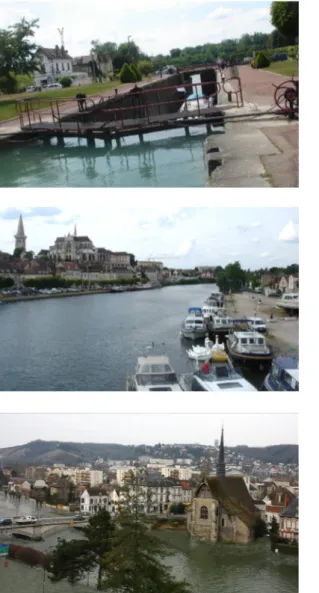
A - SENS
Sens is a French commune, the capital di-strict, located 120 km southeast of Paris in the Yonne department. This is the second largest city of the department of Yonne and the sixth in the Burgundy region. It is crossed by two ri-vers, the Yonne and the Vanne and is located in the heart of the plain of Sens.
In general, the rail traffic is established as it operates as many freight and mail throu-gh the station, on the Paris-Lyon-Marseille axis. Each day, there are over 7000 habitants of Sens that depart from the station of Sens
Figure 20 - Paris rive gauche / Fertile city, Utopia or reality? (Exposition)
“Yonne River Corridor” Network of Yonne Cities: the River as Tourist Route C. Matika with direction to work in Paris. Its Eco Park is a modern facility that concentrates all practi-cal, ecological and geographical advantages, favorable for the development of an economic activities.
B - VILLENEUVE
Villeneuve-sur-Yonne is a French commune, located in the Yonne department in its lower valley and in 2010 had 5.295 habitants. Impor-tant elements of the city are the two massive valleys with architecture of a medieval town, a tower and an open deck on the Yonne, of a pre-existing Roman city. The construction of a shopping and leisure center is in progress. C - JOIGNY
Joigny is a French commune, located in the Yonne departement. The original city was built on a promontory of the “Cuesta”, overlooking the wide river, which served as both protection and communication channel. The city is cros-sed to the south and from east to west by the Yonne. The River of Chênée rises on the north of the city and several of its tributaries. Remarkably located on the route of the road from Paris to Auxerre, the city has hostelries. Wine is an important source of activity. It mo-bilizes a lot of winemakers, coopers and wine merchants. The center of the city is so plain that very often is occupied by flood.
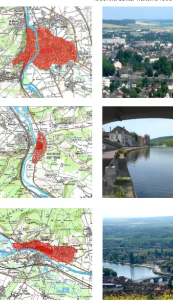
The port is in the direction of Auxerre, the last to be available most of the year and not be blo-Figure 21 - Map with Sens,
Villeneuve, Joigny, Migennes and Auxerre
[Next page]
Figure 22 - Tables indicating visits, destinations, trip dura-tion, cruise and boat choices.
“Yonne River Corridor” Network of Yonne Cities: the River as Tourist Route C. Matika
Figure 23 - Map of Sens. Figure 24 - Panoramic view of Sens.
Figure 25 - Map of Villeneuve. Figure 26 - A view in Villeneuve.
Figure 27 - Map of Joigny Figure 28 - Panoramic view of Joigny.
cked by summer low flows. Fishing is active and regulated. The bridge, from the twelfth century, is an important investment and its maintenance is funded by a toll. Joigny has also a small aerodrome open to public air traf-fic. Overall, its bridge, its rich valley propitious to pastures and culture, both vivid and cereal productive, and its strategic location were the source of its wealth, mainly due to the cultiva-tion of vines on limestone hills.
D - MIGENNES
Migennes-sur-Yonne is a French commune in the most northern Burgundy department. Lo-cated about twenty kilometers from Auxerre in the heart of the Yonne, it is at the confluence
“Yonne River Corridor” Network of Yonne Cities: the River as Tourist Route C. Matika
Figure 29 - Map of Migennes. Figure 30 - Suspension Bridge in Migennes.
Figure 31 - Map of Auxerre. Figure 32 - View of Auxerre, through the river.
Figure 33 - View of Sens as a flood zone.
of the Yonne and Armançon. In addition, Mi-gennes is the starting point of the Burgundy canal, which ends up at a distance of 242 km in Saint-Jean-de-Losne. In 2010, it had 7.243 habitants. The industrial character of the city with its largely abandoned part constitutes another important element. Finally, there is an interesting bike path.
E - AUXERRE
Auxerre is a French city capital of the Yonne department, in the Burgundy region (southeast of Paris). It is the first city in the department of Yonne, and the fourth in the Burgundy region. Divided into 11 districts, the city is recognized as a city of art and history, thanks to its
fa-“Yonne River Corridor” Network of Yonne Cities: the River as Tourist Route C. Matika mous cathedral.
In addition, it is known worldwide for its wines. This is the first economic and commercial pole of the department, and therefore plays a ma-jor role in the communication inside the re-gion. The National society of French railways station (SNCF) of Auxerre-Saint-Gervais is lo-cated on a non-electrified branch line which is connected via the station of Laroche - Migen-nes in Paris Dijon line. Finally, the river tran-sports are of major importance.
Flood constitutes a risk for the region that should be mentioned. Concerning this risk, a part of Sens city constitutes a flood zone (val-ley of Yonne and Vanne). It may therefore be subject to floods, because of river overflows, but it can also be prone to flooding due to ru-noff during storms. In case of flood, the da-mage will be much greater than it was in the past, because of the growth of urban areas and massive industrialization of flood storage areas, which were only worthless fields. PREVENTION OF FLOOD RISK
The risk connected to flood plain is the result of two components: a. a risk that is to say, the water that usually flows in the main river bed, can go out and cover all or part of its flo-odplain, b. issues related to the presence of the man who settled in the floodplain of the river as the site for construction, equipment, industrial and agricultural activities, which
are vulnerable to flooding. Figure 34 - Flood Risk, me-thods for flood prevention.
“Yonne River Corridor” Network of Yonne Cities: the River as Tourist Route C. Matika
Thus, the danger of flooding depends: firstly, on the characteristics of the phenomenon (water level and flow velocity, overflow time) and secondly, on the method of land use in the floodplain (issues) and the vulnerability of pe-ople and property. It is very important to re-mark, that “We do not fight against the floods but against damage from floods”.
As a result, the flood prevention begins with: a. Improved knowledge: archival research to know the historical floods, census and main-tenance of flood benchmarks, b. Education, awareness, information: the vulnerability of individuals depends on their prior knowledge of the phenomenon, exposure conditions and behavior adopted during the event, c. It is es-Figure 38 - The example of
Auxerre with Linear Plantations Figure 35 - Project A - every space to pedestrians (Right)
Figure 36 - Project B - a balan-ced formula (Middle) Figure 37 - Project C - the city wins on the docks (Left)
“Yonne River Corridor” Network of Yonne Cities: the River as Tourist Route C. Matika
Figure 39 - Ambiences with water element through the night
“Yonne River Corridor” Network of Yonne Cities: the River as Tourist Route C. Matika sential to develop a culture of risk and share
it with each person that works on risk mana-gement
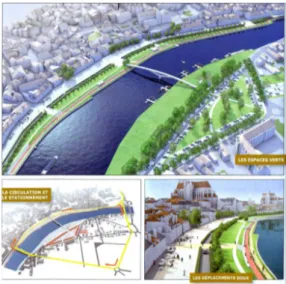
INTERVENTIONS - REDEVELOPMENT OF THE DOCKS OF YONNE RIVER
To conclude, authorities have made many ef-forts to redevelop the docks of Yonne river. The main problem is the rupture between the river and the urban space.
The project objectives are: a. to regain the banks of the river, b. to achieve continuity of shores and banks (ex. bridge), c. to articulate the element of water (river) with the banks, d. to operate projects developing the banks, like the “garden river”, “urban nature”, “bioengi-neering” and e. to accomplish the reconcilia-tion of the community with the port.
There are three propositions of re-qualifica-tion for the docks. The aim of these projects – interventions is to make the docks more user-friendly. Briefly, one offers every space to pedestrians, another constitutes a balan-ced alternative between different users (pe-destrians, cyclists, motorists) and a third one proposes the docks to be recaptured by the old city center.
Figure 40 - The example of Auxerre, proposing leisure ac-tivities
“Yonne River Corridor” Network of Yonne Cities: the River as Tourist Route C. Matika
BIBLIOGRAFIA
Alba D. (editor) (2009) Seine d’Architectures, MiniPA n 36, Editions du Pavillon de l’Arse-nal, Paris
Ambroise R., Bonneaud F., Brunet-Vinck V. (2000) Agriculteurs et paysages: Dix exemples de projets de paysage en agriculture, Edu-cagri Editions, Dijon
Bourinet S. (editor) (2010) La nature pour métier Bac pro agricole 1re et Terminale Gestion des milieux naturels et de la faune, Educagri Edi-tions, Dijon
Cité de l’Architecture et du Patrimoine (2011) La ville fertile – vers une nature ur-baine, Catalogue de l’exposi-tion, Connaissance des arts hors-série, Paris
Clavel-Lévêque M., Lorcin M. T., Lemarchand G. (1983) Les campagnes françaises: précis d’histoire rurale, Mes-sidor, Paris
Jackson J. H. (2010) Paris Under Water – How the City of Light Survived the Great Flood of 1910, Palgrave Mac-Millan, New York
Labourdette J. P., Auzias D. (2011) Tourisme Fluviale, Pe-tit Futé, Paris
McKnight H. (2005) Cruising French waterways, Sheridan House, New York
Verry P., Derinck J. P., Grapin C., Goguey R. (2009) Des Paysages à Voir et à Lire en Bourgogne, Educagri Edi-tions, Dijon SITES: www.quais-yonne.fr http://www.tourisme-yonne. com/ http://www.bourgogne-touri-sme.com/ http://www.house-boat.net/ en/bassin.aspx