2 3 Politecnico di Milano Department of Architecture and Urban Planning Master in Landscape Architecture Concentration: Landscape Architecture
Title: Agriculture Metropolitan -An Attempt to Retrieve Balance Among Human Settlement, Agricultural System and Water Ecology with Urban Agriculture in Shanghai Metropolitan
Supervisor: Boeri Stefano
Xu Yibo, 737271 Xu Xianya, 737142 AY 2009/2010 01 - THE TITLE PAGE
4 5 4 6 14 20 21 26 27 30 32 36 42 50 52 58 60 62 63 74 80 85 86 88 90 92 94 96 98 99 107 108 109 111 114 114 116 124 136 148 153 154 164 170 172 176 182 Table of Content List of Figures Abstract Eng & Ita 01 - Shanghai 1840
02 - Scenes of History
03 - Shanghai 2010
04 - Aims and Concepts
05 - Strategy to Mend 06 - Design 07 - Shanghai Manifesto Bibliography Thanks - General Information - Original Landscape
- Balance Among City, Water and Agriculture - Three Comparisons - City vs Water - Water vs Agriculture - Agriculture vs City - Our City - Our Water - Our Agriculture
- Imbalance Among City, Water and Agriculture - Concept of Permaculture
- Learn from Precedents - Methodology - Phase 1: Overview - Phase 2: Relations - Phase 3: Mend
- New Balance of City, Agriculture and Water - Techniques
- Design of Soilless Culture Centers
- Design of Over Ground Pipes - Final Photomontages - Shanghai 1840 - Food Exporter - 3 Natural Gifts - Usage of Manure - Problems - Causes - Problems - Causes - Problems - Food Production - Food Consumption - Causes - Food Insecurity
- Tool: Urban Agriculture - Mend City vs Agriculture - Mend Agriculture vs Water - Mend Water vs City - Soilless Culture - Over Ground Pipes - Overview - Under Viaducts - On Roofs - In Public Greens - Overview 02 - TABLE OF CONTENTS
6 7 Chapter 1 Chapter 2 fig.1 fig.2 fig.3 fig.4 fig.5 fig.6 fig.7 fig.8 fig.9 fig.10 fig.11 fig.12 fig.13 fig.14 fig.15 fig.16 fig.17 fig.18 fig.19 fig.20 fig.21 fig.22 fig.23 fig.24 fig.25 fig.26 fig.27 fig.28 fig.29 fig.30
Number Name Source
The Satellite Map of China
The Satellite Map of Yangtze River Delta The Satellite Map of Shanghai Metropolitan The Satellite Map of Shanghai Central Districts The Satellite Map of Shanghai Downtown in 2009 The Virtual Satellite Map of Shanghai Downtown around 1800
Shanghai Food Consumption and Exportation, 1400s Map of Water Network of Shanghai, 1800s Shanghai Water Resources
Water Transportation Route in Downtown, 1800s Water Transportation Route in Metropolitan, 1800s Downtown Water Network When High Tides Came Downtown Water Network When Low Tides Came Four Phases to Use the Tides
The Cycles of Tides in 24 hours Conclusion of the Tidal Irrigation System
The Indefinitely Sustainable Loop of City, Agriculture and Water
Aerial Photo of Shanghai Downtown
Photo of Typical Paddy Field of Shanghai, 1840s Photo of Typical Paddy Field of Shanghai, 1880s Map of Shanghai Downtown, Comparison between City and Agriculture, 1840s.
Map of Shanghai Downtown, Comparison between City and Agriculture, 1880s.
Aerial Photo of Shanghai British Concession and the Bund in 1930s
Photo of Crowds in 1960s Aerial Photo of Pudong Lujia Zui
Map of Shanghai Downtown, Comparison between City and Agriculture, 1930s.
Map of Shanghai Downtown, Comparison between City and Agriculture, 1960s.
Chart 1: Population vs Farm Labor Population Chart 2: Shanghai Construction Area vs Arable Area Chart 3: Shanghai Food Consumption vs Production
2010 Google Map Data 2010 Google Map Data 2010 Google Map Data 2010 Google Map Data 2010 Google Map Data A Photomontage Satellite Map Made AT ref.2
Illustration Made AT ref.3,4 Map Made AT Shanghai Postal Map,1930
Illustration Made AT ref.5 Map Made AT ref.6 Map Made AT ref.6 Map Made AT ref.7 Map Made AT ref.7 Illustration Made AT ref.7 Illustration Made AT ref.7 Self-Made Illustration Self-Made Illustration
From Google Search
From Virtual Shanghai Website, Institut Universitaire de France From Virtual Shanghai Website, Institut Universitaire de France Map Made AT ref.10
Map Made AT ref.12
From Virtual Shanghai Website, Institut Universitaire de France From Google Search
From Google Search Map Made AT ref.13 Map Made AT ref.14 Chart Made AT ref.18 Chart Made AT ref.19 Chart Made AT ref.20 03 - LIST OF FIGURES
8 9 Chapter 3 fig.52 fig.53 fig.54 fig.55 fig.56 fig.57 fig.59 fig.60 fig.61 fig.62 fig.63 fig.64 fig.65 fig.66 fig.67 fig.68 fig.69 fig.70 fig.71 fig.72 fig.73 fig.74 fig.75 fig.76 fig.77 fig.78 fig.79 fig.80 fig.81 fig.82
Number Name Source
Map of Shanghai Downtown, Comparison between Water and City, 1930s.
Map of Shanghai Downtown, Comparison between Water and City, 1960s.
Chart 1: Urbanization Ration vs Water Surface Ration Chart 2: Length of Roads vs that of Creeks
Chart 3: Sewage Disposal vs Water Quality
Map of Shanghai Downtown, Comparison between Water and City, 2010s.
The Urban Sprawl of Shanghai with 9 New Satellite Towns Policy
Photo of Construction Site in Shanghai
T h e L o o p A m o n g t h e L o c a l G o v e r n m e n t , t h e Developer and the Citizens and Farmers.
Photo of Pollution of Huangpu River
Photo of Suzhou Creeks full of Water Hyacinths Photo of floods of Shanghai
Map of the Flood Control Walls and Sea Dams Photo of Flood Control Wall along Suzhou Creek Illustration of the Section of Floor Contral Wall Photo of Yangshan Deep Water Port
Photo of Flood in Shanghai City Center in 2009 Photo of Polluted Water in Suzhou Creek Photo of People who Swim in River Chart of Shanghai Food Importation Photo of Chemical Fertilizers The Land Use of Shanghai Metropolitan
Map of Locations and Amounts of Grain Production M a p o f L o c a t i o n s a n d A m o u n t s o f Ve g e t a b l e Production
Map of Locations and Amounts of Fruit Production Map of Locations and Amounts of Pig Production Map of Locations and Amounts of Milk (Cow Farms) Production
Map of Locations and Amounts of Poultry Production Map of Locations and Amounts of Fishery Production Overview Map of Locations and Amounts of All Food Production
Map Made AT ref.13 Map Made AT ref.14 Chart Made AT ref.27 Chart Made AT ref.28 Chart Made AT ref.29 Map Made AT ref.16
Map Made AT ref.31 From Google Search Illustration AT ref.32-41 From Google Search From Google Search
From Virtual Shanghai Website, Institut Universitaire de France Map Made AT ref.44
From Google Search Made AT ref.44
From wikipedia, Yangshan_ Deep_Water_Port
From Google Search From Google Search From Google Search Chart Made AT ref.22 From Google Search Map Made AT ref.45 Map Made AT ref.46 Map Made AT ref.48 Map Made AT ref.49 Map Made AT ref.50 Map Made AT ref.51 Map Made AT ref.52 Map Made AT ref.53 Map Made AT ref.54 fig.31 fig.32 fig.33 fig.34 fig.35 fig.36 fig.37 fig.38 fig.39 fig.40 fig.41 fig.42 fig.43 fig.44 fig.45 fig.46 fig.47 fig.48 fig.49 fig.50 fig.51
Number Name Source
Map of Shanghai Downtown, Comparison between City and Agriculture, 2000s.
Photo of Shanghai Ancient Scenery. Water Town and Landscapes, 1840s
Photo of British Concession with Roads Covering Half of the River, 1890s
Map of Shanghai Downtown, Comparison between Agriculture and Water, 1840s.
Map of Shanghai Downtown, Comparison between Agriculture and Water, 1880s.
Photo of Drained Out Creeks in British Concession, 1930s
Photo of Polluted Suzhou Creek with Alongside Factories, 1960s
Photo of the Bund, People were Separated from the Water by Floor Control Wall in 2010
Map of Shanghai Downtown, Comparison between Agriculture and Water, 1930s.
Map of Shanghai Downtown, Comparison between Agriculture and Water, 1960s.
Chart 1: Arable Land Area vs Creek Density Chart 2: Farmlands Irrigated by the Tides vs the Rivers Influenced by the Tides
Chart 3: Amounts of Goods Transportated through the Water vs the Water Surface Area
Map of Shanghai Downtown, Comparison between Agriculture and Water, 2010s.
Photo of Shanghai British Concession. Water and Road Transportation Worked Together
Photo of Shanghai British Concession. Water was Drained out for Building the Roads.
Map of Shanghai Downtown, Comparison between Water and City, 1840s.
Map of Shanghai Downtown, Comparison between Water and City, 1880s.
Photo of Shanghai British Concession. New Roads for Cars and Trams were being Built around 1900s Photo of Shanghai Moderns Roads around 1960s Photo of Shanghai Contemporary Transportation System, Roads, Viaducts and Metros in 2010s
Map Made AT ref.16
From Virtual Shanghai Website, Institut Universitaire de France From Virtual Shanghai Website, Institut Universitaire de France Map Made AT ref.10
Map Made AT ref.12
From Virtual Shanghai Website, Institut Universitaire de France From Virtual Shanghai Website, Institut Universitaire de France From Google Search
Map Made AT ref.13 Map Made AT ref.14 Chart Made AT ref.22 Chart Made AT ref.23 Chart Made AT ref.24 Map Made AT ref.16
From Virtual Shanghai Website, Institut Universitaire de France From Virtual Shanghai Website, Institut Universitaire de France Map Made AT ref.10
Map Made AT ref.12
From Virtual Shanghai Website, Institut Universitaire de France From Virtual Shanghai Website, Institut Universitaire de France From Google Search
10 11 fig.111 fig.112 fig.113 fig.114 fig.115 fig.116 fig.117 fig.118 fig.119 fig.120 fig.121 fig.122 fig.123 fig.124 fig.125 fig.126 fig.127 fig.128 fig.129 fig.130 fig.131 fig.132 fig.133
Number Name Source
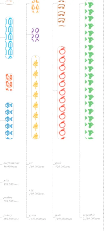
Illustration: The Scheme to Relocate the Food Production Locations in Shanghai Metropolitan Illustration: The Amounts of Food Production After Relocation
Illustration: The Conceptual Ring Chart of the New Master Plan
Illustration: The New Master Plan of Shanghai Food Production System
Photo: Controlled Green House of Soilless Culture I l l u s t r a t i o n : N e w B a l a n c e A m o n g t h e H u m a n Settlement, Agricultural System and Water Ecology with the Help of Urban Agriculture
Illustration: The Comparison of Land Shortage By using Traditional Technique and Soilless Culture Illustration: Techniques of soilless Culture for Fruit or Vegetable Production
Map: The Heights of Rise and Ebb of Huangpu River Photo: The Over Ground Pipes as Landscape in Berlin Illustration: Section of Typical Flood Control Wall in Shanghai
Illustration: The Techinques of The Intakes of Pipe System
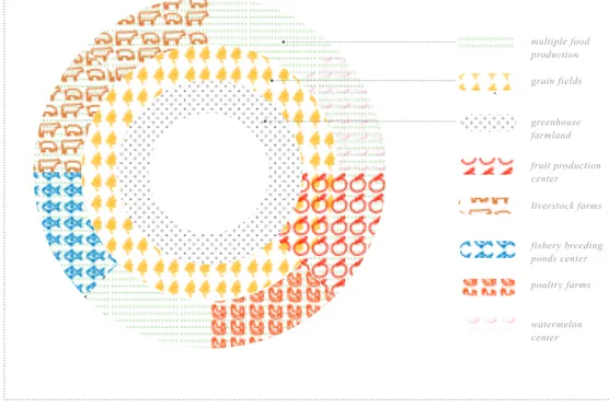
Illustration: The Whole System of Shanghai Urban Agriculture
Map: The Viaducts Spaces in City Center
Map: The Viaducts Spaces in Shanghai Metropolitan Illustration: The Table of Calculation of the Spaces Viaduct could Provide for Food Production
Satellite Map: The Sample Site, Part of Yan'An Viaduct
Photo: The Sample Site, Road under Yan'An Viaduct Photo: The Aerial View of Viaducts of Shanghai Illustration: The Plan of the Soilless Centers Under Viaducts
Illustration: The Isometric View of Soilless Centers Under Viaducts
Photomontage: The New Vision of the Spaces Under the Yan'An Viaduct
Photomontage: The New Vision of the Spaces, Birdview of the Joints
Made by Writers Made by Writers Made by Writers Made by Writers From Google Search Made by Writers
Made by Writers Made AT ref.94,95,96 Made AT ref.98 From Google Search Made AT ref.99 Made by Writers Made by Writers Made AT ref.100,101 Made AT ref.100 Made AT ref.102 From Google Earth 2010 From Google Earth 2010 From Google Earth 2010 Made by Writers Made by Writers Made by Writers Made by Writers Chapter 6 Chapter 4 Chapter 5 fig.83 fig.84 fig.85 fig.86 fig.87 fig.88 fig.89 fig.90 fig.91 fig.92 fig.93 fig.94 fig.95 fig.96 fig.97 fig.98 fig.99 fig.100 fig.101 fig.102 fig.103 fig.104 fig.105 fig.106 fig.107 fig.108 fig.109 fig.110
Number Name Source
Illustration of Overview of Food Production Illustration of Concept of Food Production System Map of Shanghai Population Distribution Chart of Diets of Shanghainese
Illustration of Shanghai Food Consumption: The Amount and Kind
I l l u s t r a t i o n o f C o m p a r i s o n b e t w e e n F o o d Consumption and Production
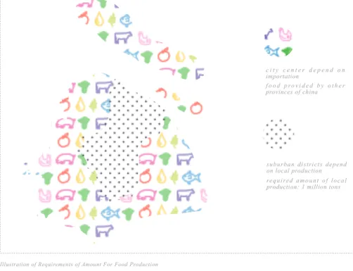
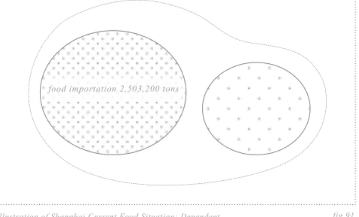
Illustration of Shanghai Food Shortage and Surplus Illustration of Current Food Situation: Dependent Illustration of Requirements of Amount for Food Production released by Central Government
Illustration of Requirements of Areas for Food released by Shanghai Municipal Government Chart of GDP of Agriculture in the History and the ration of it in the total GDP
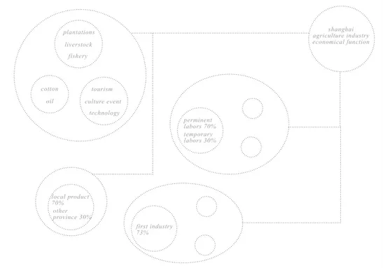
Illustration of Structure of Agricultural Economy Chart of Proportions of the 1st, 2nd and 3rd industries Illustration of Chart of Shanghai Food Production Chart of the agriculture exportation value of Shanghai Illustration:the Structure of Farmer Incomes Illustration: the Current Imbalanced System among Water, City and Agriculture.
Photos of Propaganda Poster of Autarky Photo of Dymaxion Houses by Buckminster Fuller Photo of ING Amsterdam headquarters by Meyer & Van Schooten
Photo of Drought Land in Yunan Province, 2010 Photo of Snow Disaster, 2009
Chart of Shanghai CPI Index
Idea of Turning Urban into Food Production Centers Illustration of Land Surplus and Shortage to Attain Self-sufficiency With the Current Productivities Illustration: Find the Right Food Production to Insert into Urban Area
Illustration: The Final Decision of the Selected Food Production in City
Illustration: The Table of Three Criteria to Select the Right Food in UPA
Made AT ref.55, fig.75 to 81 Made by Writers Made AT ref.57 Made AT ref.58 Made by Writers Made by Writers Made by Writers Made by Writers Made AT ref.60 Made AT ref.61 Made AT ref.64 Made by Writers Made AT ref.66 Made by Writers Made AT ref.67 Made AT ref.65 Made by Writers
From Google Search From Google Search From Google Search
From Google Search From Google Search From Google Search Made by Writers Made by Writers Made by Writers Made by Writers Made by Writers
12 13 fig.158 fig.159 fig.160 fig.161 fig.162 fig.163 fig.164 fig.165 fig.166 fig.167 fig.168
Number Name Source
Illustration: The Isometric View of the Soilless Centers In the Public Lawn in People's Square Photomontage: The New Vision of the Spaces In the Public Green, Lawns and Low Shrubs Alongside the Roads and Public Buildings
Map: Summary of The Potential Spaces for Urban Agriculture in the City Center
Illustration: Summary Tables of Calculation of All the potential Spaces for Food Production
Map: The Map of the Roads that used to be Water Network
I l l u s t r a t i o n : C o n c e p t o f H o m a g e t o O r i g i n a l Landscape
Illustration: The Location of Pipes and Their Intakes as well as The Potential Spaces for UPA
Photomontage: The New Vision in the Bund
Photomontage: The New Vision in the Nanjing Road. The Commercial Walk Street
Photomontage: The New Vision in Xintiandi. The Traditional Shikumen Commercial Walk Street Photomontage: The Future of Shanghai, Overview of Shanghai City Center
Made by Writers Made by Writers
Made by Writers Made by Writers Made AT fig.5 and fig.6 Made by Writers Made by Writers Made by Writers Made by Writers Made by Writers Made by Writers fig.134 fig.135 fig.136 fig.137 fig.138 fig.139 fig.140 fig.141 fig.142 fig.143 fig.144 fig.145 fig.146 fig.147 fig.148 fig.149 fig.150 fig.151 fig.152 fig.153 fig.154 fig.155 fig.156 fig.157
Number Name Source
Map: The Roofs Spaces Could be Used in City Center Chart: The Land Usage of Shanghai
Illustration: The Table of Calculation of the Spaces Roofs could Provide for Food Production
Satellite Map: The Sample Site, Roof of China Pavilion
Photo: The Sample Site, China Pavilion
Photo: The Aerial View of Roofs of Shanghai City Center
Illustration: The Plan of the Soilless Centers On the Roof of China Pavilion
Illustration: The Isometric View of Soilless Centers On the Roof of China Pavilion
Photomontage: The New Vision of the Spaces On the Roof, China Pavilion
Photomontage: The New Vision of the Spaces On the Roof, The Ciy Center
Map: The Spaces in City Public Greens Chart: The Land Usage of Shanghai
Illustration: The Table of Calculation of the Spaces Public Green could Provide for Food Production Satellite Map: Sample Site, Forest in Century Park Photo: The Sample Site, The Forest in Century Park 1 Photo: The Sample Site, The Forest in Century Park 2 Illustration: The Plan of the Soilless Centers In the Forest in Century Park
Illustration: The Isometric View of In the Forest in Century Park
Photomontage: The New Vision of the Spaces in the Public Green, Forest in Big Parks
Photomontage: The New Vision of the Spaces In the Public Green, Interior
Satellite Map: The Sample Site, The Public Lawn in People's Square
Photo: The Sample Site, The Public Lawn in People's Square 1
Photo: The Sample Site, The Public Lawn in People's Square 2
Illustration: The Plan of the Soilless Centers In the Public Lawn in People's Square
Made AT ref.101,103 Made AT ref.103 Made AT ref.101,103 From Google Earth 2010 From Google Earth 2010 From Google Earth 2010 Made by Writers Made by Writers Made by Writers Made by Writers Made AT ref.101,103 Made AT ref.103 Made AT ref.101,103 From Google Earth 2010 From Google Earth 2010 From Google Earth 2010 Made by Writers Made by Writers Made by Writers Made by Writers From Google Earth 2010 From Google Earth 2010 From Google Earth 2010 Made by Writers
14 15 This paper is about the past, now and future of Shanghai. / Past / Two hundred years ago, Shanghai was a small water town surrounded by rich farmlands and dense creeks. The nature granted locals with resources and reciprocally habitants nourished the ground with manures. The indefinitely sustainable loop among human settlement, agricultural system and water ecology created a permanent agricultural society and an original identity of Shanghai, Green. / Now / While, as time goes by, Grey dominates in the process of industrialization and urbanization. The rise of Grey and fall of Green opened a pandora's box. The original balance among city, water and agriculture broke up and a vicious cycle emerged. / Mend / The sick system need to be mended; The balance among city, water and agriculture will be regained; The original identity Green will be retrieved. In order to achieve these goals, a concept and a tool are introduced. The former, permaculture, provides methodology and strategy for revising the system while the latter, urban agriculture, helps to handle practical problems. We believe the conflicts among city, water and agriculture can be solved by the urban agriculture system. / Future / The harmony among human settlement, agricultural system and water ecology will bring better city and better city will provides better life. One day, we will not worry about unhealthy and insufficient food, polluted environments and boring public spaces; One day, our offspring will enjoy the same beautiful sceneries our ancestors used to do; One day, green agriculture and green water will return to Shanghai.
PREFACE 04 - ABSTRACT - ENGLISH VERSION
16 17 Questa tes è per il passato, l'ora e il futuro di Shanghai./ Passato / Duecento anni fa, Shanghai era una città d'acqua circondata da terreni agricoli ricco e denso insenature. La natura concessi con le risorse locali e reciprocamente abitanti nutrito il terreno con concimi. Il loop all'infinito sostenibili tra insediamenti umani, il sistema agricolo ed ecologia delle acque ha creato una società agricola permanente e di una identità originaria di Shanghai, Verde. / Ora / Anche se, col passare del tempo, Grigio domina nel processo di industrializzazione e urbanizzazione. L'ascesa e la caduta di Grey di Green ha aperto un vaso di Pandora. L'equilibrio originario tra città, l'acqua e l'agricoltura si sciolse e un circolo vizioso emerse. / Riparare / Il sistema malato bisogno di essere riparata; L'equilibrio tra città, l'acqua e l'agricoltura è recuperato, l'identità originale verde sarà recuperato. Al fine di raggiungere questi obiettivi, un concetto e uno strumento vengono introdotte. Il primo, permacultura, fornisce la metodologia e la strategia per la revisione del sistema mentre il secondo, agricoltura urbana, aiuta a gestire i problemi pratici. Crediamo che i conflitti tra città, l'acqua e l'agricoltura può essere risolto dal sistema di agricoltura urbana. / Futuro / L'armonia tra gli insediamenti umani, il sistema agricolo ed ecologia delle acque offriranno migliori città e di migliore città si prevede una vita migliore. Un giorno, noi non ci preoccuperemo sugli alimenti insalubri e insufficienti, ambienti inquinati e noioso spazi pubblici; Un giorno, i nostri figli potranno godere i paesaggi belli i nostri antenati lo stesso utilizzato per fare, un giorno, l'agricoltura e verde acqua verde tornerà a Shanghai.
PREFAZIONE 05 - ABSTRACT - ITALIAN VERSION
20 21 上海 / 古话云, 民以食为天。但是在如今的中国,经济的发展牢牢地 占据了主动。曾经的农业大国已经改变了其发展的目标。上海是中 国经济最繁荣的城市之一,同时也是经济改革的先锋。在三十多年 经济改革和城市发展的过程中,上海忽视了农业的重要性。在过去 的数十年里,中心城区的面积已大大地扩张。至二零零九年,城市 化率已经达到了百分之八十五。在城市大扩张的同时,农业用地渐 渐地消失。在城市发展奇迹的背后,是农业的牺牲。在接下来的文 章中,我们将介绍上海城市与农业发展的过去和现在。在了解历史 和当前的问题之后,希冀通过分析和设计探索其新未来的可能性。 我们相信,城市和农业的和谐发展是人们生活品质提高的前提。
CHAPTER ONE SHANGHAI 1840
06 - MAIN BODY OF THESIS
The Satellite Map of China fig.1
fig.2
fig.3
fig.4 The Satellite Map of Yangtze River Delta
The Satellite Map of Shanghai Metropolitan
The Satellite Map of Shanghai Central Districts yangzte river
yangzte river
yangzte river
huangpu river shanghai metropolitan
yangzte river estuary tai lake
suburban area huangpu river
shanghai center area yangzte river
delta east china sea
huang river
'Food is the First Necessity of People' / China used to be the empire of agriculture. The food was the most important issue in any dynasty through the history. However, nowadays compared to the urgent need for economical development, agriculture has lost its previous importance, especially in those developed metropolitans such as Beijing, Guangdong and Shanghai etc. Among them, Shanghai is the very typical one paid too much attention to economy while little to agriculture. / General Information of Shanghai / In the national scale, Shanghai situates in the east coast of China, facing Pacific Ocean. The Yangtze River to its north provides most of its fresh water resources. The other important river is Huangpu River , the mother river of Shanghai. It carries fresh water from Taihu Lake and crosses the very heart of the city. Nowadays the whole metropolitan covers an area of 6340.5 square kilometers and holds 20 million habitants. The sands and muds from the upstream of Yangtze river formed the main land of Shanghai as well as the world's largest sand island, the Chongming Island in its north see fig.1, fig.2, fig.3, fig.4. / As the leader city of the Yangtze River Delta (including Jiang Su and Zhe Jiang Province), Shanghai becomes one of the most prosperous cities in China, especially in city construction and economic development. During the past decades, 'thanks to' many urban development policies, the central area of Shanghai has expanding largely. Until 2009, the urbanization ration of Shanghai has risen to over 85%. Its successful urban development has been recognized as a miracle and a model for other cities in China. At the same time, Shanghai is labelled as one of the most important international commercial hubs in the far east A s ia s ee ref.1 .
22 23 上海的现状 / 如今的上海由钢筋混凝土铸 造。地图中可以清晰的见到,上海市区呈 现惨寂的灰色。上海的母亲河,黄浦江, 是我们在这张图上可以看到的唯一明显的 自然元素。然而,这样的景象早已与原来 的上海相差甚远。出于对历史的好奇,对 上海原始地域特性的探求,我们不禁会问: 在这一层"灰色"下层隐藏了什么?上海在 经济飞跃前是什个么模样?它确是全球化 大炼炉中那些国际大都市中的普通一座? fig.5
The Satellite Map of Shanghai Downtown in 2009
The Downtown of Shanghai in 2009, a City Full of Grey / The downtown region is the very place that represents the rapid urban development of Shanghai. It centers the Bund, Lujia Zui Commercial Center in Pudong Area and the Huangpu River, the mother river of Shanghai. The downtown covers an area around 120 square kilometers. To the north it extends to Hongkou D i s t r i c t w h i c h u s e d t o b e t h e international concession (ruled by Americans and Japanese); To the east it arrives at the Century Park, the biggest green in the downtown; To th e s o uth it comes to 2 010 EXPO site, the China Pavilion; To the west it ends at Luwan district which was the French Concession. T h i s r e g i o n h a s b e e n t h e v e r y h e a r t o f S h a n g h a i t h r o u g h o u t its history. / In the satellite map of the downtown see fig.5, the downtown area is overlayed with grey patterns, the buildings and infrastructures. They represent the contemporary identity of Shanghai and its triumph of urbanization. While, as a Shanghai local, I have been wondering what my hometown used to be? what is the history of the urbanization and what were the layers behind the concrete?
24 25 上海的过去 / 在阅读了大量的文献和研究 成果后,我们尝试着还原上海在开埠前的 状态。左图是虚拟的十九世纪初上海卫星 地图,除了老城厢以外,基本就是一望无 际富饶的农田和四通八达的水网。如果说 上 海 有 其 与 生 俱 来 的 秉 性 的 话 , 那 一 定 是这些"绿"与"蓝"的交织。但遗憾的是, 在二个世纪飞速城市化的过程中,灰色的 混 凝 土 抹 去 了 曾 经 的 色 彩 , 城 市 渐 渐 被 剥 夺 了 那 时 的 秉 性 。 如 今 想 必 已 没 有 人 会将这个国际化大都市与水乡相联系了。 fig.6
The Downtown of Shanghai around 1800, a City Full of Green / After reviewing the related archives and researches see ref.2, we succeeded in figuring out the virtual satellite map of the Shanghai downtown around 1800 see fig.6. Shanghai was full of farmlands, especially the paddy fields. Besides those fields, water was another important e l e m e n t o f S h a n g h a i o r i g i n a l landscape. At that time, the whole Yangzte River Delta was covered with millions of creeks and rivers. The nature granted Shanghainese convenient transportation routes and sufficient fresh water. With t h o s e a d v a n t a g e s , t h e a n c i e n t Shanghainese were able to develop large tracts of farmland. The whole agriculture, social and economical system is called Water Town, which was typical in the Yangzte Delta and still exists in the far suburban areas of Shanghai. / Well, now we know the original vision of Shanghai: it was a water town. The creeks and farmlands shaped the lifestyle of ancient Shanghainese. If it had a original identity, that must be green, the green fields and the green creeks. However, those has extincted in current downtown.
26 27 曾经的粮食基地 / 同时令人惊讶的是,如今的粮食消耗大户曾经是一个富饶的粮食生产基 地。据文献记载,约在公元一三九一年,上海区域(按现在行政区域划分)拥有住民约 五十三万人,按照当年的人均粮食消耗量来计算,年粮食需求在十六万吨左右。而资料显 示,当年全区域约产出五十三万多吨粮食,其中三十七万多吨会送至全国其他各地。从 上海通过内河航道可运至浙江,江苏等邻近省市,通过长江可运送至武汉等内陆省市, 通 过 海 运 可 以 输 送 至 北 京 和 福 建 。 到 此 , 我 们 会 疑 问 是 什 么 因 素 造 就 了 昔 日 上 海 这 富 饶 的 鱼 米 之 乡 , 在 繁 荣 的 农 业 背 后 她 又 享 有 着 什 么 样 得 天 独 厚 的 自 然 区 域 风 貌 和 人 文 背 景 。 绿色的背后:三个自然的因素 / 研究分析后,我们发现上海的繁荣农业离不开当时三个独特的自然因素。首先,曾经四通八达的水网,为上 海的农业经济提供了交通资源。其次,充足的淡水资源为上海人口发展和农业灌溉提供水资源。最后,农民趋利避害的运用上海的潮汐,让 上海这个临海的区域即能享受潮汐送水的力量又能避免海水倒灌的烦恼。以下便一一叙述这三大自然因素如何赋予上海绿色农业的秉性。 第一个因素,四通八达的水网 / 曾经的上海 密布着大大小小的河浜水道,其中影响最大 的是流经上海北部涌入东海的长江和从太湖 流来贯穿市中心的上海母亲河黄浦江。以这 两条河流为基础,上海的水路网络延展至四 周,她们是当时上海农业经济迅速发展的最 重要基石。当日上海住民们都依河而居,有 河流的地方便有人家,从而形成传统的水 乡。而且,在当时的技术条件下,便捷的水 路运输要比路上运输更加的快速,安全,经 济。通过内河网络,货物和旅客可以往来于 周边的省市。通过长江江运,货物和旅客可 以溯流而上进入中国内陆。通过东海海运, 货物可以南至福建台湾北至天津卫。当然, 在拥有天然水网的基础上,水资源本身以及 如何利用水资源的能力同样是至关重要的。 第二个因素,充足的淡水资源 / 当今的上海被称为水质性缺水城市,意指虽然淡水资 源充足但水源污染严重从而无法被利用。实际上,工业大发展前上海的淡水资源非 常充沛的。根据数据,上海百分之九十的淡水资源来源于长江,剩余百分之十来源于 黄浦江。水网不仅给上海带来了运输的便捷,也为其提供了充足的水源。长久以来, 稻米一直是上海住民的主要粮食,全境内大部分的粮田都是稻田。因此充足的淡水 资源为上海稻田的发展提供了不可或缺的基本资源,也造就了长三角肥沃的土地。 15 30 45 KM 0
SUFFICIENT WATER SUPPLY: THE REASON FOR SHANGHAI ORIGINAL LANDSCAPE
Before the urbanization and industrialization, the area of Shanghai was full of water networks. The main rivers are two, one is the Huangpu River, what is the mother river of Shanghai, bringing fresh water from the west Taihu Lake to the center of Shanghai and finally merging with Yangzte River. The other is the Yangzte River, it provides 90% of the fresh water supply for Shanghai.
25 50 75 KM 0
944.2 BILLION CUBIC METERS OF FRESH WATER RUNNING THROUGH SHANGHAI
With huge amounts of fresh water supply, it was easy for the farmers to develop agriculture, especially the rice fields, which were and are the main food of Chinese people.
jiangsu prov. beijing taiwan anhuiprov, zhejiang prov. henan prov. fujianprov. loca l grain co nsumption:159, 840 t ons
grainexportation:375,959ton
s
sh
an gh
ai gra
in production:535,800to ns
fig.7 Shanghai Food Consumption and Exportation Situation Around 1400s
yangzte river
huangpu river
tai lake shanghai
shanghai area fresh water from huangpu riv er freshwa terfro m yan gtze river
955.5 billion cubic meters
10.7 billion cubic meters fig.8 Map of Water Network of Shanghai Metropolitan Around 1800s
fig.9 Shanghai Water Resources
A City of Green, A City of Grains / According to Shanghai Professional Records: Agriculture Records see ref.3, in 1391, the population of Shanghai was 532,803. The total production of the grain (mainly rice) per year was over 535,800 tons. Assuming that the average grain consumption of one person at that time was 300 kilograms see ref.4, the total consumption of the grain in Shanghai region was around 159,840 tons. The surplus 376,000 tons of grain were exported to other part of China and other big neighbor provinces see fig.7. Naturally with the great natural environment, Shanghai used to be the grain production
The First Natural Advantage: The Dense Water Network / Shanghai w a s f u l l o f c r e e k s a n d r i v e r s . As shown in the fig.8, the whole metropolitan was covered with dense water network. In general, there are two major arteries, one is Huangpu River, the mother river of Shanghai. The other is Yangzte River. It meets Huangpu River at its estuary and finally runs into East China Sea. In order to use the advantage of dense water network, people built their water towns along the riverside. With the creeks and rivers, the food could be transported from the local farmlands to towns and villages efficiently. With the Yangzte River, the food could be sent to the inner provinces of China. And with East China Sea route, the food could be delivered to Beijing in the north and Fujian in the south . The Huangpu River, the Yangzte River and the East China Sea shaped a chain of water network. This ensured the efficient and safe food transportation as well for other goods see fig.10 and fig.11.
The Second Natural Advantage: Ample Fresh Water Resources / The water network not only provided routes for the transportation but also granted water for the crops and human livings. The Yangzte River and the Huangpu River provides separately 90% and 10% o f t h e f r e s h w a t e r s u p p l y f o r S h a n g h a i p e r y e a r s e e f i g . 9 , s e e ref.5. With huge amounts of fresh water from the nature, Shanghai farmers were able to develop large tracts of agriculture, especially the paddy fields, which produced the main food of Chinese people. center as well as the transportation
transit in the east coast of China. It produced 3 times grains more than its habitants needed. / However, unfortunately, the previous big food exporter has changed into a big food importer and put big burden on other provinces. The identity of Shanghai has totally shifted.
Three Natural Advantages Helped Shanghai to Be a Food Exporter / Shanghai was born to be a food production center. At least the nature granted three advantages for it. First, the dense water network; Second, the sufficient fresh water supply; Third, the tidal irrigation system. The ancient Shanghainese had learned how to make the best use of them.
28 29 第三个因素,自然赋予的潮汐力量 / 在拥有了充足的水源和发达的水网之后,还需要思考 的是如何利用这些资源。古代的上海住民运用他们的智慧,利用潮汐的自然特性,发明了 一套采集淡水资源的方法。众所周知,临海城市都会遇到海水潮汐倒灌的问题,上海也不 例外。上海的潮汐属于典型的半日潮,即在一个太阴日内出现两次高潮和两次低潮,前一 次高潮和低潮的潮差与后一次高潮和低潮的潮差大致相同,涨潮过程和落潮过程的时间 也 几 乎 相 等 。 高 潮 时 , 海 水 猛 于 长 江 水 流,托举着河水涌入内陆,内河中便含有 盐水和半盐水。低潮时,河水高于海水, 将其推出内陆流回东海。根据这一系列自 然现象,上海农民设计了一套水闸用来趋 利避害,引淡水拒海水。 / 四个步骤利用 潮汐 / 第一步:引潮 / 首先,在高潮来临前 打开闸门,海水在涌入内陆的同时会托起 河水,被抬高的淡水流过闸口进入稻田水 渠之中已备使用。此步骤至关重要,需要 了解潮汐的准确时间,若失败了会误将半 咸水引入农田造成农作物的损伤和土地的 盐碱化。 / 第二步:挡潮 / 当高潮正式出现 时,主河道中的水流已基本由半盐水和海 水构成,此时要关闭闸门,将有害于作物
HIGH TIDES SITUATION
When the high tides come, the fresh water coming from the Yangzte River and Huangpu River is lifted up by the sea water and flourish the Shanghai inner land area. The fresh water agriculture needs would be granted by the nature day by day continously.
fig.10
fig.11 Shanghai Water Transportation Route in Downtown Area Around 1800s
Shanghai Water Transportation Route in Metropolitan Area Around 1800s
fig.12
fig.13 Map of Shanghai Downtown Water Network When High Tides Came
Map of Shanghai Downtown Water Network When Low Tides Came
Four Steps to Use the Tides / In order to made the best use of the tides, Shanghai farmers developed an interesting way to utilize the natural power. The process could be divided into four phases. The ultimate goal was to use the fresh water and block out the brackish and sea water see ref.7. / Phase 1: Welcome the High Tides / Before the high tides came, the open gates were ready to direct the fresh water inside the fields. The incoming sea water from East China Sea would lift up the fresh water from the Yangzte River and push it into the inner land of Shanghai. The lifted up fresh water would rush into the fields through the open gates for irrigation and human settlement usage. / Phase 2: Block Out the Salty water / However, the sea water would merge with the fresh water in the middle layers and form brackish water. After the high tides arrived, the gates were closed to forbid the salty water. The fresh water was saved in the inner land creeks for usage. The Third Natural Advantage: The Tidal Power / Because of special
geographical situation, Shanghainese developed a unique irrigation system. It based on the natural power, the tides. The tide of Shanghai is diural, which means everyday there are two high tides and two low tides see ref.6. When the high tides came, the water (including the fresh water, brackish water and sea water) was pushed into the inner land creeks and lifted up the river level, thus providing the water resource for the Shanghainese see fig.12. When the low tides came, water returned to the Yangzte River and East China Sea. Some creeks would dry out because of the low tides see fig.13.
30 31
的咸水挡在闸门之外,这样,淡水就被保存在水渠之中以供人们使用。 / 第三步:用潮 / 当淡水涌进后,人们开始抓紧潮汐之间的时间
间隔使用淡水资源。农民用来灌溉,居民打水备用,同时将生活垃圾冲入水流下游以待开闸。 / 第四步:退潮 / 当海水退潮,水位下降
时,人们打开闸门,已经被使用过的废水,携带着居民们的垃圾冲入自然的河道涌入大海,开始自然降解的过程。同时,人们开始等待 下一次的涨潮。当初的上海人民便每天遵循着这潮汐规律,农民利用他们的智慧将自然的力量化为己用,避免了本是灾祸的潮汐倒灌。
THE CYCLE OF AGRICULTURE, CITY AND NATURE
The tides brought sufficient fresh water into the lands. The farmers used them for irrigation. Then, they
transported the productions to the city through the water network. The city grew with food. The polluted
water from the city then was washed away by the tides. With the natural self purification the discards of
the city became the natural elements again. And the loop started another time.
BALANCE OF AGRICULTURE, CITY AND WATER
STEP 02 TO USE THE TIDAL POWERWhen the high tides arrived, the gates were closed to forbid the brackish water. The fresh water was con-tained inside the farmland field for agriculture and living use.
THE USAGE OF TIDES TO IRRIGATE THE AGRICULTURE
rice fields
natural creeks
human made canals for irrigation huangpu river sea water entered the river network brackish water
mixed water fresh water contained for irrigation close gates block out the brackish water
STEP 03 TO USE THE TIDAL POWER
When the tides fade away, people irrigated the farmlands with the water saved. THE USAGE OF TIDES TO IRRIGATE THE AGRICULTURE
rice fields
natural creeks
human made canals for irrigation huangpu river brackish water
mixed water fresh water coming
into island wash away the sea water used water after human usage farmlands irrigation close gates block out the brackish water
STEP 04 TO USE THE TIDAL POWER
When the low tides arrived, people opened the gates to let the polluted water come out into the natural system. The fresh water continued to wash away the dirty water around the human settlement.
THE USAGE OF TIDES TO IRRIGATE THE AGRICULTURE
rice fields
natural creeks
human made canals for irrigation
fresh water coming into island wash away the polluted water huangpu river used water
flowing away into huangpu river open gates let the polluted water go away
STEP 01 TO USE THE TIDAL POWER
Before the high tides came, the gates were opened to let the fresh water come inside which was lifted up by the tidal sea water. The incoming sea water will merge with the fresh water in the middle layers.
rice fields
natural creeks
human made canals for irrigation huangpu river sea water incoming
with high tides brackish water mixed water fresh water lifted
by the sea water fresh water coming into rice fields open gates let fresh water in
fig.14 fig.16
Four Phases To Use The Tides Conclusion of The Tidal Irrigation System
Step 01:
Before The Highest Tides Coming
Step 02:
The Highest Tides Arrive
Step 03:
The Tides Fade Away
Step 02: The Lowest Tides
STEP 02 TO USE THE TIDAL POWER When the high tides arrived, the gates were closed to forbid the brackish water. The fresh water was con-tained inside the farmland field for agriculture and living use. THE USAGE OF TIDES TO IRRIGATE THE AGRICULTURE
STEP 03 TO USE THE TIDAL POWER When the tides fade away, people irrigated the farmlands with the water saved. THE USAGE OF TIDES TO IRRIGATE THE AGRICULTURE STEP 04 TO USE THE TIDAL POWER When the low tides arrived, people opened the gates to let the polluted water come out into the natural system. The fresh water continued to wash away the dirty water around the human settlement. THE USAGE OF TIDES TO IRRIGATE THE AGRICULTURE
STEP 01 TO USE THE TIDAL POWER Before the high tides came, the gates were opened to let the fresh water come inside which was lifted up by the tidal sea water. The incoming sea water will merge with the fresh water in the middle layers.
12 hours step 02 step 01 step 03 step 04 fig.15 The Cycles of Tides in 24 hours
natural self-purification tides washed away
dirty water tides lift water
water with
human discards fresh water
city consumption rice fields
water transportation
natural phenomenon came every 12 hours see fig.15, provided the essential fresh water for the agriculture system, washed away the dirty water around the human settlement. In general, the whole process could be described Phase 3: Use the Water and Wait for
Ebbing / During the break between rise and ebb, farmers would use the captured fresh water as much as possible and dumped the dirties and wastes inside the water network.It was a phase for the human usage. / Phase 4: Wastes Washed Away by the Ebbs / When ebbing came, the water level outside the gates lowered. At that moment farmers would open the gates and let the used water run away together with the ebbs. Thus the whole cycle finished. The whole procedure would happen twice a day to keep the crops irrigated and the human lives going on see fig.14. The Cycle of Tides / The tides, the
32 33 曾经的天人合一 / 古时的上海居民将自己的 生活完全的融入到自然循环之中。水,农 田,生活形成了一个不停歇的良性循环,互 惠互利的同时又互不侵犯。遵循着大自然的 力量,便产生了一个和谐的过程。她构建 了上海最初始的本质。 / 上海原本的性格 / 在 了 解 到 上 海 开 埠 前 真 实 的 场 景 后 , 回 看 如 今 的 上 海 , 过 去 的 绿 色 变 成 了 如 今 的 灰 色 。 追 根 溯 源 , 如 果 说 上 海 有 其 独 特 的 本 质 的 话 , 那 便 是 农 田 与 水 网 的 交 织 , 人 类 与 自 然 的 和 谐 。 过 去 的 景 象 为我们呈现的是一幅既陌生又熟悉的水乡 风 情 画 。 赞 叹 感 慨 之 余 , 我 们 也 不 禁 要 问,水乡风景画如何演变成了如今绚烂的 混凝土大都市?在这二百年间,水,农业 和城市之间的和谐是如何打破的?在下一 章节中,我们会详细的展现这一个过程。 self purification farmland agriculture city consumption water city agriculture fig.17 The Indefinitely Sustainable Loop of City,Agriculture,and Water
disca rds g abb age s food supply wa ter irrig ati on fr esh wat er puri fic ation manure self-purification happened. In the counter-clockwise, water p r o v i d e d h u m a n s e t t l e m e n t with fresh water. The human settlement returned manure as fertilizers to the agricultural system. The agricultural system helped in purifying the water and save it in the underground w a t e r l a y e r. T h e c l o c k w i s e and counterclockwise together f o r m a l o o p a m o n g h u m a n settlements, agricultural system and natural ecologies, which w e r e m u t u a l l y b e n e f i c i a l .
T h e O r i g i n a l C h a r a c t e r s o f Shanghai / The original vision o f S h a n g h a i e m e rg e s . A n c i e n t S h a n g h a i n e s e l i v e d i n w a t e r towns. People went out by ships, carried cargos by ships and even l i v e d o n s h i p s . T h e w a t e r a n d human wastes created a perminent agriculture. The scenery was full of crop fields, trees and creeks. To conclude, if Shanghai had an identity, it would be the chrods of city, water and agriculture, the green. It could be considered as an indefintely sustainable system. Those three built up a perminent
and indefinite sustainalbe cycle. To c o n c l u d e t h i s c h a p t e r , w e present a ring chart see fig.17 to describe the structure of the original balance among human settlements, agricultural systems and natural ecologies. In the clockwise, the nature provided agriculture with f r e s h w a t e r t h r o u g h t i d e s a n d convinient water network. And the agriculture granted food for human being through water transportation. Then, the human settlements left the wastes to the water, where natural as following: The tides brought
s u f f i c i e n t f r e s h w a t e r i n t o t h e lands. The farmers used them for irrigation. Then, they transported the productions to the city through the water network. The city grew with food. The polluted water from t h e c i t y t h e n w a s w a s h e d a w a y by the tides. With the natural self purification the discards of the city became the natural elements again. And the loop started another time see fig.16. / The Extra Advantage: Manure / Besides the good natural resources, Chinese developed another important method to keep the arable land rich and health. The key was the manure of the human and livestock. The following two citations from the foreign scholars could best represent its great function in keeping the b a l a n c e o f o r i g i a n l a g r i c u l t u r a l system. 'One of the most remarkable agricultural practices adopted by any civilized people is the centuries-long and well nigh universal conservation and utilization of all human waste in China, turning it to marvelous account in the maintenance of soil fertility and in the production of food. The method to cultivate the crops by Chinese was different from the mineral fertilizers so extensively e m p l o y e d i n m o d e r n w e s t e r n agriculture, like the extensive use of mineral coal, which had been a physical impossibility to all people alike until within very recent years. In fact, the very long unbroken life
of China and the vast numbers its farmers have been compelled to feed proved the success of the reusing manure as natural fertilizers.' 'In selecting rice as their staple crop; in developing and maintaining their systems o f c o m b i n e d i r r i g a t i o n a n d drainage, notwithstanding they have a large summer rainfall; in their systems of multiple cropping; in their extensive and persistent use of legumes; in their rotations for green manure to maintain the humus of their soils and for composting; and in the almost religious fidelity with which they have returned to their fields every form of waste which can replace plant food removed by the crops, these nations have demonstrated a grasp of essentials and of fundamental principles which may well cause western nations to pause and reflect.' see ref.8. D r. A r t h u r S t a n l e y, H e a l t h officer of the city of Shanghai, in his annual report for 1899, also wrote: "...While the ultra-civilized Western elaborates destructors forburning garbage at a financial loss and turns s e w a g e i n t o t h e s e a , t h e Chinaman uses both for manure. He wastes nothing while the sacred duty of agriculture is uppermost in his mind. And in reality recent bacterial work has
s h o w n t h a t f a e c a l m a t t e r a n d house refuse are best destroyed b y r e t u r n i n g t h e m t o c l e a n soil, where natural purification takes place. ... the product of an evolution extending from more t h a n a t h o u s a n d y e a r s b e f o r e t h e C h r i s t i a n e r a . " s e e re f . 9 . Thanks to Franklin Hiram King and Dr.Arthur Stanley, we could obtain information in detail on what Shanghai used to be and how the agriculture, city and water worked together. The advantages were natural resources and the k e y w a s t h e m a n u r e . T h e f o u r together kept the whole social, economical and ecological system working soundly. / The Perminent A g r i c u l t u r e / F r a n k l i n H i r a m K i n g c a l l e d t h i s e n d l e s s l o o p 'Perminent Agriculture', which means an indefinitely sustainable a g r i c u l t u r a l s y s t e m s e e re f . 8 . This word cuts the point. Ancient Chinese people have been believing in the endless cycle for thousands of years. From the tiniest thing to the universal life, everything could be explained as an endless loop. The agriculutre system was one of the master pieces of the ancient Chinese wisdoms on perminent loop. / The Harmony / Now, with deep understanding of the ancient Shanghai agriculture system, we get the whole picture of the perminent a g r i c u l t u r e a n d t h e b a l a n c e among water, agriculture and city.
人类的回赠,粪便的使用 / 除了自然的三 个因素外才,中国人对于自然的尊敬对于 整个系统的平衡也起到了非常大的作用。 中国人对于人类和牲畜粪便的循环使用使 的 土 地 数 千 年 来 反 复 的 耕 种 成 为 可 能 。 不 同 于 西 方 所 使 用 的 化 肥 , 中 国 农 民 一 直 坚 持 使 用 人 畜 粪 便 进 行 浇 灌 , 通 过 自 然 的 过 程 增 加 土 地 的 肥 力 。 这 样 的 过 程 被 外 国 的 学 者 称 之 为 ‘ 永 恒 农 业 ’ , 一 个 一 直 良 性 循 环 自 给 自 足 的 人 与 地 的 和 谐 系 统 。 在 1 9 世 纪 初 , 美 国 农 业 经 济 学 家 F r a n k l i n H i r a m K i n g第一次在他的 著 作 中 提 到 了 这 一 概 念 。 这 个 不 同 于 西 方 的 耕 作 模 式 正 式 中 国 人 一 大 发 明 。
34 35 fruit
36 37 二百年变迁 / 航拍图显示上海市中心城区建设已经基本饱和,原本繁荣的农业早已寻不 到踪影。在这一章节中,我们将从农业,城市,水系这三元素之间的关系变化入手,展 示他们各自在这两百年的发展轨迹。其中包括三组历史发展过程的比较: 城市与农业, 农业与水系以及水系与城市。通过三组比较,将展示三个曾经形成良性循环的关联元 素如何在城市大发展的过程中瓦解。研究的时间跨度将从一八四零至二零一零年。上海 这个曾经的渔村,自从十九世纪初被英国殖民者入侵之后,便踏入城市化发展阶段。 这近二百年间演绎了这个渔村从"绿"到"灰 "的篇章。为涵盖上海最中心和历史最悠 久的城区,我们将研究对象区域限制在如 今的上海市区,即北至虹口区,原公共租 界北界,东至浦东世纪公园,南至世博会 园区,西至闵行区,原法租界的西边界。
CHAPTER TWO SCENES OF HISTORY
people square the bund
lu jia zui pudong area
expo
fig.18 Aerial Photo of Shanghai Downtown
Where is the Green / When looking at the aerial view photo of Shanghai see fig.18, we see the splendid EXPO site and the dense Pudong commercial center. For a tourist, it is a shocking city. But after knowing what it used to be, we have to ask a bitter question: where is the green and those creeks. Nowadays, the whole city is overlayed by the concretes. The original water town disappeared. We have to say the current identity of Shanghai is 'Generic', like other metropolitans. The good-old thing is lost. As a local, I am eager to know why. In this chapter, we will see through the history to know how green turned into grey. / Methodology: Study Period and Three Contrasts / After the first Opium War, Shanghai was assigned as the port for foreign trade. The establishment of the first concession triggered its urban development. It was seemed as the start of Shanghai modern history. Thus, our studies will range from the middle of 19th century till now. Then, the developments of three elements will be analyzed in detail: the human settlements, the agricultural systems and natural ecologies,
especially water environments. As we know, they shaped the endless loop and the original identities of Shanghai. We could understand how Shanghai lost its original identities by following their changes. While, since they are interrelated, it will be better to study their interactions t h r o u g h t h e h i s t o r y t h a n o n l y individuals. Thus, we will present three pair comparisons to better understand the procedure. They are the contrasts between city and agriculture, between agriculture and water and between water and city. puxi area
38 39
21
城市与农业,一八四零年至二零一零年 / 城市在扩张的过程中不断吞噬农业用地, 在两百年历史中,农田逐渐被钢筋混凝土 所取代。在这几页里,以每四十年为一个 分 析 的 节 点 , 我 们 将 呈 现 这 一 过 程 。 此 外我们能够发现,城市对于自然的压迫是 水系,农业和城市三者循环断裂的开始。 CITY VS AGRICULTURE: 1840With the amply water, interlinked network and advanced irrigation techniques, ancient Shanghainese developed broad fields of farmlands. According to the British description, ‘outside the Shanghai old town there were nothing but farmlands’. Actually, in the beginning of 19th century, Shanghai produced much more food than it needed and exported its surplus production to the capital Beijing via Huangpu river. The sufficient food supply together with the convienient food transportation system by water ensured the stable population and high standards of living qualities.
CITY VS AGRICULTURE: 1880
Protected by four rivers, a piece of land in the north of Yangjin river and south of Suzhou river was chosen
as the British Settlement, which was the location of the famous Bund. The concessions provided safe
shel-ters for the refugees and the business men during that war period. Besides that, the development of the
Bund port and high modernized city environment of the foreign concessions pushed the urban
develop-ment of Shanghai to the north, followed by the French settledevelop-ment in the north of the old city and the
American settlement in the north of Suzhou River.
puxi area
puxi agriculture area
yangshupo port american colony
french colony british colonythe bund chinese town chinese town jiangnan shipyard barrack pudong area pudong area shanghai old town
shanghai old town 16 pu port
16 pu port shipyard
fig.21
fig.22 Map of Shanghai Downtown. Comparison of City and Agriculture in 1840s
Map of Shanghai Downtown. Comparison of City and Agriculture in 1880s fig.19
fig.20 Photo of Typical Paddy Field of Shanghai in 1840s
Photo of Typical Paddy Field of Shanghai in 1880s
The First Comparison: The Human Settlements vs The Agricultural Systems / The History from 1840s to 2010 / In 1840s, the Great Britain and its East Indian Comapny used the war to open five ports in order to sell the opium to China. Shanghai was one of the destination for those drugs. While, the invaders brought up the urbanization of this small village. / 1840s: the City / The fig.21 shows the contrast between city and agriculture in 1840s in the downtown Shanghai area see ref.10. Here we could see the ancient Chinese town of Shanghai situated in the riverside of Huangpu River. As a trade city for foreign companies, Shanghai started to establish many ports along Huangpu River. One of the earliest and most famous ports, 16 Pu Port came into existence in the east of the old town. People from all around China attracted by the business opportunities started to immigrate to Shanghai and settled there. This tendency led the first population bloom of the metropolitan and pushed the city towards an international trade center and commercial center.
1840s: the Agriculture / With the amply water, interlinked network, tidal irrigation techniques and usage of manure, Shanghainese developed large tracts of farmlands. The fig.19 shows the typical paddy field around Shanghai town. The farmer directed the fresh water into the creeks by the lifting machine (the wood equipment in the picture) to irrigate the fields. At that time, agriculture dominated the whole l a n d s c a p e . / 1 8 8 0 s : t h e C i t y / P r o t e c t e d b y f o u r r i v e r s , t h e land between Yangjin river and Suzhou river was chosen as the British Settlement, which later b e c a m e t h e f a m o u s B u n d . T h e concessions provided safe shelters for the refugees and the business men during the war periods see ref.11. The development of the Bund port and highly modernized city environment of the foreign concessions further stimulated the urban development of Shanghai see ref.12. It was followed by the French settlement in the north of the old city and the American settlement in the north of Suzhou R i v e r s e e f i g . 2 2 . / 1 9 3 0 s : t h e C i t y / I n o r d e r t o b u i l d m o r e factories, ports and residences, foreigners grabbed more lands to expand concessions see fig.23. The British concession together with American and Japanese became t h e i n t e r n a t i o n a l c o n c e s s i o n s ,
40 41 fig.26
fig.27 Map of Shanghai Downtown.Comparison of City and Agriculture in 1930s
Map of Shanghai Downtown.Comparison of City and Agriculture in 1960s
pudong area pudong area dongchang yangpu yulin tilangqiao beihongkou putuo zhabei jiangning changning xuhui luwan penglai xincheng huangpu yimiao ports in pudong chuansha district international concessions chinese area zhabei district
puxi area
the bund
french concessions
chinese area, nanshi area
shipyard shanghai old town
16 pu port fig.23
fig.24
fig.25 Aerial Photo of Shanghai British Concession and the Bund in 1930s
Photo of Crowds in 1960s
Aerial Photo of Pudong Lujia Zui International Commercial Center
which occupied most lands in the north of Shanghai. The French expanded to the west of Shanghai a s f o r h o u s i n g a n d c u l t u r a l facilities of their own interests. The sprawl of the city was the results of the enlargement of the concessions see fig.26 and ref.13. 1930s: the Agriculture / Besides the urban development, the new rail ways and roads made the local food supply unimportant. Shanghai c o u l d i m p o r t f o o d f r o m m u c h farther places than ever before. The farmlands near the center area became meaningless. / 1960s: the City / In that era, Shanghai was seen as the factories for the whole China. Thus, more factories were e s t a b l i s h e d . T h e f o r m e r w a t e r town became a generic industrial city. With the population bloom and labor immigration see fig.24, Shanghai expanded and occupied several districts from surround provinces. In order to meet the n e e d o f a c c o m o d a t i o n s , t h e previous foreign concessions were transformed mostly into workers community houses. They became the famous living blocks ‘Lilong’. While, thanks to unability to cross Huangpu River economically and efficiently, the urban development remained in the west bank. The east bank remained rural see fig.27 and ref.14. / 1960s: the agriculture / In order to feed the huge population, the central minister assigned a lot of farmlands from other provinces t o S h a n g h a i . T h i s f o r m e d t h e current territory of the metropolitan see ref.15. / 2010: The city / The biggest step of Shanghai urban sprawl in the previous decades was