Summary
Geological and structural evolution of tectonically
active areas of the central Calabrian Arc
Abstract ... 1
Riassunto... 2
Introduction and aim of the work ... ... 4
2.1 Reaarch activities ... 6
Chap. 1 – Geographic setting ... ... 9
Chap. 2 – Geological setting ... ... 11
2.1 Geodynamic of the Mediterranean region ... 11
2.2 Tectono-stratigraphic features of CPA ... 12
2.2.1 Geologic features of northern CPA ... 15
2.2.2 Geologic features of southern CPA ... 17
2.2.2.1 Serre Massif ... 17
2.2.2.2 Aspromonte Massi and Peloritain Mountains... 18
2.3 Structural and geological backgrounds of Catanzaro Trough ... 19
2.3.1 Structural features of Catanzaro Trough ... 19
2.3.2 Geological features of Catanzaro Trough ... 21
Chap. 3 – Geological field study of Catanzaro Trough ... 22
3.1 Geological features of Catanzaro Trough ... 22
3.2 Middle - Upper Miocene deposits ... 23
3.2.1 Serravallian- Tortonian sequence ... 23
3.2.2 Messinian sequence ... 25
3.3 Sedimentary units of Catanzaro Trough ... 28
3.3.1 Late Messinian- Lower Pliocene conglomerates sequence ... 28
3.3.2 Pliocene limestone-marl sequence ... 30
3.3.4 Middle-Upper Pleistocene Terrace sequence ... 33
3.3.4 Late Quaternary sequence ... 33
Chap. 4 – Structural field study of Catanzaro Trough ... ... 36
4.1 Structural analysis ... 36
4.1.1 rotational axis (rotaxes) ... 37
4.2 Northern structural domain
... 38
4.2.1 Structural data ... 40
4.3 Southern structural domain
... 44
4.3.1 Structural data ... 44
4.4 Stress inversion for the Catanzaro Trough ... 49
4.4.1 Miocene –Zanclean faults population ... 49
4.4.2 Piacezian- Lower Pleistocene faults population ... 51
4.4.3 Post Lower Pleistocene faults population ... 51
Chap. 5 - Geophysical data ... ... 55
5.1 Geophysical methods ... 55
5.1.1 Acquisition of seismic reflection data ... 55
5.1.2 Processing ... 56
5.2 Seismic data analysis ... 57
5.3 Multichannel seismic profiles and wells by ViDEPI project ... 58
5.3.1 Onshore ViDEPI seismic data ... 60
5.3.1 Offshore ViDEPI seismic data ... 61
5.4 ISTEGE Project Data ... 64
5.4.1 Multi-Channel Seismic profiles (MCS) ... 65
5.4.2 Morpho-bathymetric features ... 67
5.4.3 Chirp seismic profiles ... 68
5.5 Sparker Seismic Profiles ... 70
Chap. 6 Active tectonics ... ... 73
6.1 Catanzaro Trough Basin: historical earthquakes and active faults ... 73
6.1.1 Central Calabrian Arc historical earthquakes ... 74
6.2 The 28 March 1783 and 8 September 1905 earthquakes inversion ... 76
6.2.1 Methods and data ... 77
6.3 Focal mechanisms of recent earthquakes ... 79
6.3 Focal mechanisms of new recent earthquakes ... 84
Discussion and conclusion ... 86
d.1 Plio-Quaternary structural evolution of the western Catanzaro Trough ... 86
d.2 Reconstruction of Catanzaro Trough seismotectonic ... 91
d.3 Concluding remarks ... 92
References ... 94
Web Sites ... 110
Appendix ... 111
a.1 Northern domain ... 111
d.2 Southern domain ... 113
Attachment 1 Geological Map ... ... Attachment 2 Structural Map ... ...
ABSTRACT
The Catanzaro Trough is a Neogene-Quaternary basin developed between the Serre and the Sila Massif, filled by up to 2000 m of Upper Miocene to Quaternary sedimentary succession, belonging to the central Calabrian Arc and extended from offshore, Sant’Eufemia Basin (SE Tyrrhenian Sea), to the onshore, Catanzaro Basin.
By joining on land geo-structural with marine geophysical data, we performed a detailed analysis of processes that during last 5 My have controlled the evolution of western portion of the Catanzaro Trough. The fieldwork study, focused on the onshore area, has allowed to acquire more than 700 fault planes, classified on the base of kinematics and fault directions, whereas the geophysical data (sub-bottom, multi- and mono-channel seismic profiles), coming from some scientific cruises within the Sant’Eufemia Gulf (SE Tyrrhenian Sea), gave us the opportunity to reconstruct the tectono-stratigraphic evolution of the offshore area.
The combination amongst abrupt sea level changes, transpressional and trans/extensional tectonics and back-arc Tyrrhenian subsidence during SE-drifting of Calabrian Arc controlled sedimentary basin hosted by the Catanzaro Trough, as the result we have recognized three tectonic events formed in the Upper Miocene- Zanclean, Piacezian-Lower Pleistocene, and Middle-Upper Pleistocene.
The data analysis provide information about stratigraphy and tectonics in the strata and also give some indication of the tectono-stratigraphic architecture. Sedimentary basin, in fact, looks to be mainly controlled by the activity of NW–SE and NE–SW oriented fault systems.
The NW-SE oriented faults showing strike slip and oblique kinematics can be considered responsible for the opening of a WNW–ESE paleo-strait connecting the Tyrrhenian Sea with the Ionian Sea during multi-phases tectonics that have acted in the study area since Miocene. The integrated geo-structural and geophysical data show a change from left-lateral to right-lateral kinematics during Piacezian-Lower Pleistocene, as the result of a change of the stress field.
Since Middle Pleistocene, the study area experienced an extensional phase, WNW-ESE oriented, controlled mainly by NE-SW and subordinately N-S oriented normal faults, which split obliquely the western Catanzaro Trough, producing up-faulted and down-faulted blocks, arranged as graben-type systems, extending from onshore to offshore area.
In agreement with and Jacques et al., (2001) and Presti et al., (2013), the NE-SW and N-S trend normal faults play a relevant role as part of recent seismotectonic processes controlling the Late Quaternary geodynamic of the central Calabrian Arc, representing the source of the main destructive earthquakes occurred in the area.
Thanks to these multidisciplinary approach we are able to provide a more reliable and detailed structural frame of the central Calabria segment, providing new elements about recent activity of faults, and giving a further contribution for the seismogenetic potential assessment of an area historically considered with the highest earthquake and tsunami risk throughout Italy.
KEY WORDS: Calabrian Arc, strike slip faults, extensional tectonics, seismotectonic.
RIASSUNTO
La stretta di Catanzaro è un bacino sedimentario caratterizzato da una successione sedimentaria compresa tra il Miocene ed il Quaternario, che raggiunge uno spessore di 2000m,. Questo bacino è collocato nell’ Arco Calabro centrale, compreso tra il Massiccio delle Serre e quello della Sila e si estende dall’offshore tirrenico, bacino di Sant’Eufemia (Mar Tirreno meridionale), sino all’onshore calabrese, rappresentato dal bacino di Catanzaro.
La realizzazione di questo progetto ha comportato necessariamente un approccio multidisciplinare, dove l’integrazione di informazioni di carattere strutturale, geologico, geofisico e sismotetettonico è risultato di fondamentale importanza per la definizione dell’ evoluzione tettonica neogenica-quaternaria dell’area.
La combinazione dei dati geologico-strutturali acquisiti nell‘onshore calabrese (più di 700 piani di faglia distribuiti su circa 40 stazioni di misura strutturali, classificati in base alla cinematica e all’orientazione) ed i dati geofisici (profili sismici multicanale, monocanale e ad alta risoluzione) provenienti da alcune crociere scientifiche condotte all’interno del Golfo di Sant’Eufemia, hanno permesso un’analisi dettagliata dei processi che hanno controllato la Stretta di Catanzaro negli ultimi 5 milioni di anni, sia nella sua porzione onshore che offshore.
NE-SW. L’analisi dei dati ha permesso di definire come il sistema NW-SE sia caratterizzato da una cinematica trascorrente, con una chiara componente estensionale, il quale ha gestito nelle prime fasi evolutive, legate all’apertura del paleo-stretto, agendo come zona di trasferimento ed accomodamento tensionale tra l ‘Arco Calabro settentrionale e quello meridionale.
Lo studio integrato di dati geofisici e geologici testimoniano un’inversione cinematica durante il Piaceziano, in cui la trascorrenza sinistra viene sostituita da una cinematica destra, a causa probabilmente di un cambio del campo tensionale agente all’interno della Stretta di Catanzaro.
Dal Pleistocene medio, il quadro strutturale è ulteriormente complicato dall‘attivazione del sistema con cinematica normale orientato NE-SW a subordinatamente N-S, ed estensione orientata WNW-ESE, i quali bordano una serie di strutture, tipo graben, che segmentano la Stretta di Catanzaro in vari sottobacini, un esempio è rappresentato dal Bacino di Lamezia.
In accordo con Jacques et al., (2001) e Presti et al., (2013), i sistemi di faglia NE-SW e N-S giocano un ruolo rilevante nel quadro sismotettonico dell’area del tardo Quaternario; questi lineamenti strutturali rappresentano, infatti, le sorgenti sismiche dei più distruttivi terremoti avvenuti nell’Arco Calabro centrale.
Grazie ad un approccio multidisciplinare, è stato possibile fornire una descrizione più realistica e dettagliata del segmento centrale dell’Arco Calabro. contribuendo così a migliorare la conoscenza scientifica di un’area considerata ad elevato rischio sismogenetico e tsunamigenico.
Introduction and aim of the work
Strike-slip faults systems can be considered as the faults system that mainly affect the Earth’s crust. Geometrical characteristics and abundance of these faults depend by several factors, anyway them presence is considered as the kinematic consequence of large-scale motion of plates (Wilson, 1965).
Strike-slip systems frequently control opening of sedimentary basins that, hence, show a complex geometry, due to the along strike fault perturbation which can form pull-apart and fault wedge basins. In these systems where the extension faults are obliquely associated to the margin of main transcurrent faults, we can observe transtensional basins sensu stricto (Ingersoll & Busby 1996) characterized by highly geo-structural complexity (Allen et al., 1996, Ingersoll, 2012).
Basins formed by transtensional zones are commonly characterized by en echelon arrays of normal faults obliquely oriented to the boundaries of the deformational zone (Allen et al., 1996, Waldrom, 2005). One or both margins of this transtensional zone may be a normal faults system, as studied by Beauchamp (1998) in the High Atlas Triassic-Jurassic basins, or a strike-slip fault, such as the Plio-Quaternary Loreto region within the Baja California (Zanchi, 1994). In the world, numerous examples of large sedimentary basins controlled by strike-slip faults system can be quoted, as the Dead Valley (Christie-Blick & Biddle, 1985) and submarine basins underlying the Gulf of Aqaba (Ben-Avraham, 1985), the Cayman trough (Leroy et al 1996) and Gulf of California (Pesaud et al., 2003) and the Scotia-Antarctic plate boundary zone (Bohoyo et al., 2007). Transcurrent tectonic setting also are common in obliquely convergent settings where interplate strain is partitioned into arc-parallel strike-slip zones within the fore-arc, arc or back-arc region (Fitch, 1972; Beck, 1983; Jarrard 1986; Sylvester, 1988; Diament et al., 1992; Hanus et a., 1996; Sieh & Natawidjaja 2000; Cunnigham et al., 2007). Strike-slip systems, in this geological setting, rotate and act as element of accommodation.
The Calabrian Arc (Southern Apennines, Mediterranean Sea; Fig. i.1) can be considered one of the most interesting subduction systems due to the high level of structural complexity where strike slip faults play a relevant role during the evolution of the region which, since Tortonian time, favor the southwestward drifting of the arc and its fragmentation blocks (Ghisetti et al., 1979; Turco et al., 1990; Finetti & De Ben, 1986; Van Dijk et al. 2000). This tectonic setting produces extensional faults along the Tyrrhenian side, frequently organized in
graben-like systems, forming a normal faults belt running for about 370 km of length from the Crati Valley to the Hyblean Plateau (Monaco and Tortorici 2000; Tortorici et al., 2003).
Deep sedimentary basins are hosted by both longitudinal extensional fault and transversal strike-slip fault systems. Indeed, in the central Calabrian Arc the deep Catanzaro Trough (Fig. i.1) is bounded by a large strike-slip faults zone crossing the entire emerged arc from the Ionian to the Tyrrhenian Sea (Finetti & De Ben, 1986; Tansi et al. 2007, Del Ben et al., 2008; Milia et al., 2009), dividing the arc in two main parts. Despite the several studies and models (Van Dijk & Scheepers, 1995, and reference therein; Knott & Turco , 1991; Guarnieri, 2006; Milia et al., 2009), the controlling factors of the origin of transversal strike-slip zones still under debate.
The aim of this work is to define the Plio-Quaternary evolution of Catanzaro Trough and the role of transverse and longitudinal faults, as part of the differential evolution between northern and southern sector of the Calabrian Arc.
We have used an innovative multidisciplinary approach, combining onshore with offshore, and geological with geophysical data, to assess the complex structural framework of the study area, and to understand the role played by the Catanzaro Trough as element of accommodation during the evolution of Calabrian Arc.
The fieldwork study, focused on the onshore area, has allowed to acquired more than 700 fault planes, which have been classified on the base of kinematics and fault directions. While, geophysical data (Multibeam data, Multichannel and Sparker profiles; SE Tyrrhenian Sea) were acquired during two oceanographic surveys, carried out in the Sant’Eufemia Gulf aboard the R/V OGS-Explora (summer of 2010) and the CNR R/VBannock (Trincardi et al. 1987). Further insights have been obtained using seismic profiles and Marta and Marisa drilling wells, deriving from Eni (Ente Nazionale Idrocarburi ex Agip S.p.A) investigations (ViDEPI project) occurred in the onshore and offshore of study area.
Part of this study was focused on the Catanzaro Trough seismotectonic. We have collected data, including historical earthquakes inversion (Srovich and Pettenati, 2007), some well constrained first-motion focal mechanisms (Guerra et al 2006) and all the available crustal focal mechanisms computed for the study region by using waveform inversion methods (Li et al., 2007; D'Amico et al., 2010, 2011; Presti et al., 2013). In this collected data, we also included two new focal mechanisms computed through the CAP waveform inversion method provided by D’Amico from Physics Department University of Malta.
i.2 Research activities
The research activities were organized in different phases during three years:
1. reference study: the study of references was concentrated to reconstruct the scientific background relating to geological and structural setting of Calabrian Arc, part of this study is oriented to group the main research topics: e.g. structural geology, geophisics, Quaternary geology and, active and recent tectonic, regarding structural models of similar study areas;
2. acquisition of topographic and technical maps: we have used three type of topographic and technical maps with different scale:
• 1:10000 edited by Cassa del Mezzogiorno with technical assistance of Italian Military Geographic Institute (IGM);
• 1:5000 and 1:25000 Regional Technical Chart of Calabria Region, georeferenced in UTM system;
• 1:25000 geologic map edited by Cassa del Mezzogiorno;
3. study of aerial photos: derived from photogrammetric surveys conducted in 1983 (scale 1: 33000) and 1990 (1:33000) by the Italian Military Geographic Institute (IGM) in Florence (Piccarretta and Ceraudo, 2000, Ceraudo, 2003);
4. field trip acquisition data: we acquired new structural datasets, mainly brittle elements, collected along the onshore segment of Catanzaro Trough, related to the main faults system. The structural data were organized in ca. 40 of stations measurement, distributed above basement rocks and Neogene-Quaternary deposits;
5. interpretation of geophysical and wells data:
• Onshore data analysis and wells study: we used geophysical and wells documentation collected by Eni s.p.a. (italian oil company) at the beginning of the 80' and provided to users in the frame of the VIDEPI Project (Visibility of Petroleum Exploration Data in Italy). The public technical documents related to the Italian exploration activities were realized by UNMIG-National mining office for hydrocarbons and georesources of Ministry of Economic Development, (unmig.sviluppoeconomico.gov.it/videpi/);
• Offshore data analysis Interpretation of geophysical data (Sparker, multichannel seismic – MCS, sub-bottom profiles – Chirp and high resolution morpho-bathymetry), obtained during two scientific cruise in the Sant’Eufemia Gulf (ISTEGE Project and 1987 oceanographic cruise aboard the R/V Bannock); Interpretation of well data and seismic lines (ViDEPI Eni project);
6. research activities, performed in Department of Earth Sciences - Durham University from November 2014 to April 2015, was supervisored by the Dr. Nicola De Paola. The goal has been to elaborate structural data, coming from geological surveying acquired along Catanzaro Trough, geological field mapping and analysis of Catanzaro Through basin evolution.
7. integrated study of active faults by using:
• ITaly HAzards from CApable faulting (ITHACA) is a database aimed at collecting and analyzing all available information on active tectonic structures in Italy, with particular regard to tectonic processes able to generate natural hazards. The project deals with active capable faults, which are defined as faults that have significant potential for displacement at or near the ground surface;
• Database of Individual Seismogenic Sources (DISS) is a georeferenced repository of tectonic, fault, and paleoseismological information expressly devoted, but not limited, to potential applications in the assessment of seismic hazard at regional and national scale;
• historical earthquakes inversion (Srovich and Pettenati, 2007); • first-motion focal mechanisms (Guerra et al 2006);
• available crustal focal mechanisms computed for the study region by using waveform inversion methods (Li et al., 2007; D'Amico et al., 2010, 2011, Presti et al., 2013);
• finally, we also include two new focal mechanisms computed through the CAP waveform inversion method provided by D’Amico from Physics Department University of Malta.
CHAP.1 Geographic setting
The study area, named Catanzaro Trough, is located in the western portion of central Calabria, along the Tyrrhenian side. With reference to 1:25000 Regional Technical Chart of Calabria Region, the study area is located in the following sections (Fig. 1.1):
• 570; II Filadelfia section;
• 574; I Lamezia Terme, II Curinga and IV Castiglione Marittimo sections; • 575; I Catanzaro, II Catanzaro Lido, III Girifalco and IV Pianopoli sections; • 580; IV Squillace section.
Figure 1.1: 1:25000 Regional Technical Chart of Calabria Region. The used sections are underlined with a blue line and show in the inset.
Morphologically, the territory passes eastwards from the Tyrrhenian coastal plain, commonly called Piana di Sant'Eufemia, to sweet hilly landscape, observed within the central Catanzaro Strait. In this area the hills reach more than 400 meters high; whereas both to north
and to south the area is bordered by two mountains belts, Sila and Serre uplands. Moving from the Catanzaro Trough to the two uplands, the morphology shows an alternation of steep scarps and flight of wave-cut surfaces and/or thin-depositional platforms, representing the palaeoshorelines and the erosional surfaces or marine terraces respectively.
The area is characterized by small, highly irregular rivers, named ‘fiumare’ for their often dry streams. Through the northern and southern mountain ranges, the river channels show V-shaped river with steep gradients of flow. When they reach the sedimentary sequences within the Catanzaro Trough the streams display a sudden decreasing of channel slope, forming gentle valleys.
The most important river in the area is the Amato river, which rises on Sila upland. Next to the Catanzaro Trough, Amato river, as well as other minor torrents, change its drainage pattern, passing before flowing onto Sant’Eufemia Gulf from ca. N-S to NE-SW oriented trends. Eastward, Corace river represents the main river of the area, even this rises on Sila upland and flowing down in the Ionian sea, showing along all of its watercourses ca. same N-S drainage pattern.
CHAP. 2 Geological setting
2.1 Geodynamic of the Mediterranean region
Geological and geophysical studies, carried out in the last decades, have stated that the central Mediterranean region is characterized by three structural domains: the foreland, the hinterland and the orogenic domain (Ben Avraham 1990, Lentini et al., 1994, 2006, Van Dijk & Scheepers 1995, Finetti et al., 1996, Critelli, 1999; Critelli et al., 2013).
The foreland domain includes the currently undeformed continental areas consisting of the Apulian and African plates, the two foreland areas are separated since late Paleozoic by the inferred oceanic crust of part of the Ionian basin (Fig. 2.1; Lentini et al., 2006, Finetti et al., 2005). The hinterland domain is represented by Corsica-Sardinia block and the back-arc Tyrrhenian basin opening since the Serravallian time (Fig. 2.1). This latter is characterized by the oceanic crust covered in the eastern part by Miocene- Holocene deposits. Finally the orogenic domain is composed by the Apennine-Maghrebian belt and by the Calabrian- Peloritan Arc that superimposed to the Apennines in the southern part (Fig. 2.1; Gueguen et al., 1998, Faccenna et al., 2005, Carminati et al., 2005, Lentini et al., 2006, Milia et al., 2009).
2.2 Tectono-stratigraphic features of CPA
The western Catanzaro Trough represents a Neogene- Quaternary sedimentary basin belonging to a well-developed arc-shaped structure, the Calabrian Arc (Amodio-Morelli et al., 1976; Tortorici, 1982).
Calabrian Arc is a fragment of Alpine chain connecting the southern Apennine with Maghrebide Block. The SE-ward roll-back of the Ionian slab beneath the orogenic arc, controlled by the Nubian - Euroasian plates convergence (Fig. 2.2), caused rapid opening of the back-arc basin and the migration of the Calabrian block (Malinverno & Ryan 1986, Faccenna et al. 2005). This last is driven by opposite vertical axis rotation along the WNW-ESE oriented northern and southern edges (Mattei et al., 2007), the Pollino and Taormina Lines (Fig. 2.2) respectively (Amodio-Morelli et al., 1976, Ghisetti & Vezzani, 1982, Langone et al., 2006).
Figure 2.2: The geological framework of the Central Mediterranean region (modified from Van Dijk et al., 2000).
The result of the rapid trench migration is the opening of the Tyrrhenian back-arc basin during Upper Miocene -Pleistocene age (Fig. 2.3; Finetti et al., 1986, Neri et al., 1996, 2012), and the fragmentation of CPA into structural highs and transversal marine sedimentary basins (Ghisetti 1979, Tansi et al., 2007, Tripodi et al., 2013), including Catanzaro Trough.
Figure 2.3: Cross section showing Plio-Quaternary slab retreat of southern Tyrrhenian sea (modified from Gueguen et al., 1998)
According several authors, the Ionian slab has partially or completely undergone detachment (Wortel & Spakman, 1992, Guarnieri et al., 2006). Neri et al., 2009 state that the subducting oceanic crust is apparently continuous over depth only beneath the central part of the Calabrian Arc, while the detachment should have already occurred in correspondence of the Arc edges, namely Pollino and Taormina Lines. The relict of this once large subduction zone is presently limited to an extremely narrow (<200 km), deep (>400 km) and steep (70°) NW dipping Wadati‐Benioff zone (Selvaggi and Chiarabba, 1995). In response to the Ionian slab detachment, the whole of the CPA undergoes a general tectonic rebound (uplift), at a rate of 0.5–1.2 mm/yr in the last 1–0.7 Ma, when the propagating tear passes underneath the plate margin segment (Monaco et al., 1996, Wortel & Spakman, 2000). All these observations suggest that the rollback in the Tyrrhenian- Calabrian system is almost stopped or significantly slowed down.
The active tectonic regime in Calabria is characterized by a NW–SE oriented extension, with T-axes about perpendicular to the chain axis, suggesting that the dominance of
compression driven by the Nubian-Eurasian plate convergence no longer holds there. The GPS velocity running from the Corsica-Sardinia block to the CPA, shows that there are no evidences of active extension in the Tyrrhenian basin. On the contrary, a NW–SE shortening (at a level of 1.4 ± 0.6 mm yr−1) is likely to be accommodated there. The whole NW–SE extension affecting the CPA is of the order of 3.0 ± 0.6 mm yr−1, 2.0 mm yr−1 of which are accommodated on land (D’ Agostino et al., 2004, Serpelloni et al., 2007, 2010).
The CPA comprise a number of superimposed Jurassic-Cretaceous ophiolitic sequences, and Hercynian and pre-Hercynian continental basement rocks that are in part affected by varying grades of later Alpine retrograde metamorphism (Amodio Morelli et al., 1976; Atzori
et al., 1984; Del Moro et al., 1986; Bonardi et al., 2001, Butler et al., 2004, Iannace et al.,
2007). The Paleozoic metamorphic and plutonic terranes of the CPA represent the remnants of Caledonian, Hercynian and Alpine orogens (e.g. Amodio Morelli et al., 1976; Schenk, 1981; Zanettin Lorenzoni, 1982; Atzori et al., 1984; Del Moro et al., 1986; Zeck, 1990; Messina et al., 1994, Piluso and Morten 2004, Cirrincione et la., 2011), which during Oligocene to early Miocene times have undergone a drifting from the southern Iberian plate to Adria-Africa lithosphere (Critelli et al., 1999).
Erosional remnants of the CPA (Critelli et al, 2013) is characterized by the two main superimposed metamorphic and crystalline units, belonging to Calabrian Terranes (sensu Tansi et al., 2007), which lie, in turn, on Mesozoic Carbonates Units of the Apennine- Maghrebide chain since the Early Miocene (Critelli, 1999; Rossetti et al., 2004; Iannace et al., 2007; Vignaroli et al., 2012). These basement units are juxtaposed by means of low angle overthrusted contacts, which are dissected and folded by later high angle faults of Middle Miocene- Recent age, ordered in different fault systems and patterns, partly related to transcurrent faulting (Van Dijk et al., 2000).
Basically, the crystalline basement outcropping in the CPA is made of:
• Jurassic to Early Cretaceous ophiolite-bearing sequences with foliated slates, black metapelites and metasilts, and red mudrocks and thin levels of laminate marble (Bousquet, 1963, Vezzani, 1968, Ogniben, 1973, Amodio-Morelli, 1976, Tortorici, 1982, Critelli et al., 2013), these units are referred to the Liguride Complex (sensu Ogniben, 1969, Knott, 1987), outcropping in the northwestern portion of the study area, here named Metapelitic and Ophiolitic Units.
• Paleozoic igneous- metamorphic sequences, belonging to Calabride Terranes (Messina et al.,, 1991a, 1991b), are, in turn, tectonically superposed of the Tethyan
micaschist, and subordinately marbles and high-grade metamorphic rocks (biotite-sillimanite-garnet gneiss), intruded by plutonic bodies (Ogniben, 1969, Amodio-Morelli et al., 1976, Messina et al., 1994).
The difficulty to correlate the tectono-stratigraphic units of northern with those of southern Calabrian Terranes, revealed by the outcrops, has led to consider CPA as the result of juxtaposition of two sectors, divided by Catanzaro Trough and characterized by different structural setting and geodynamic evolution (Bonardi et al., 1980, 2001, Scandone e al., 1982, Tortorici et al., 1982, Boccaletti et al., 1984b, Dercourt et al., 1985). There is a general scientific agreement on the existence of three main differences between the two sectors, with reference to the southern CPA:
• Lack of Apenninic units underlying Calabrian Terranes; • Lack of Ophiolite-Bearing units;
• Lack of Alpine metamorphism characterizing the crystalline basement.
2.2.2 Geological features of northern CPA
The northern sector, extended from Pollino Line to Catanzaro Trough, is made of two mountain chain Catena Costiera and Sila Massif (Piluso and Morten 2004) which show an overall similar tectonic evolution and can be described as the superposition of three major structural elements (Fig. 2.4) representing different paleogeographic domains:
Figure 2.3: Sketch map of the simplified tectonostratigraphic terranes of the northern Calabrian Arc (modified from Critelli 1999)
1. the lowermost Mesozoic ‘Apennines’ Carbonate units (Fig. 2.4; Van Dijk, 2000), corresponding to a continental platform composed by dolomitic partly epimetamorphic limestone of Triassic age, correlated by Van Dijk (2000) to the Monte Cocuzzo-San Donato- Campotenese Unit, overlain by the Triassic- Jurassic platform and the basinal transition limestone and dolostone belonging to Verbicaro Unit (Ietto & Barillaro 1993, Iannace et al., 1995, Perrone 1996, Liberi et al., 2006);
2. the intermediate Liguride complex, composed of ophiolite-bearing sequences belonging to the neo-Tethys realm (De Roever 1972, Dietrich and Scandone 1972, Lanzafame et al., 1979, Beccaluva et al., 1982, Guerrera et al., 1993, Cello et al., 1996) has been subdivided into several tectonometamorphic units: the Diamante–Terranova unit, consisting of metabasites (derived from pillow lavas and breccias, hyaloclastites and rare serpentinite bodies) overlain by metasediments comprising calcschists, phyllites and quarzites of Jurassic-Lower Cretaceous age (Cello et al., 1996). The Gimigliano–Monte Reventino unit: comprises basal mafic and ultramafic rocks passing stratigraphically to quartzites, quartz-mica-schists, marbles, and calcschists (Colonna and Piccarreta, 1975, 1977), the (upper) Malvito unit, composed of Jurassic-Lower Cretaceous metabasites (mostly pillow lavas) and of a sedimentary cover of radiolarian cherts and Calpionella limestones, locally reaching albite-lawsonite metamorphic facies conditios (Fig. 2.4; Amodio Morelli et al. 1976, Cello et al., 1991, 1996); the Bagni unit, consisting of Hercynian phyllites and a Triassic (?)-Lower Cretaceous sedimentary cover, showing a lower greenschist facies metamorphic overprint (Cello et al., 1996).
3. the uppermost Calabride complex, consisting of a nearly continuous continental lithospheric section, created during the Hercynian (Graessner and Schenk 2001, Piluso and Morten 2004) has been characterized by two tectonometamorphic Units: Sila Units is the uppermost Alpine thrust Nappe, consisting in its deeper part of granulites-facies gneisses (Monte Gariglione Unit), as well as the overlying amphibolite- facies upper-crustal gneisses and low-grade Palaeozoic rocks, (Mandatoriccio and Bocchigliero Units): intruded by Late Hercynian granitoids of Sila Batholith (Messina et al., 1991a, 1994, Caggianelli et al., 2000, Graessner and Schenk, 2001). The Longobucco sequence represent the Mesozoic sedimentary cover (Messina et al., 1994). The second tectonometamorphic sequence, the Castagna Unit, established by Dubois and Glangeaud (1965), represents a pervasively mylonitised horizon consisting of medium-high grade metamorphic rocks (para- and orthogneiss, micaschist,
marble and amphibolite gneiss) intruded by late-Hercynian granitoids (Bonardi et al., 2001, Sacco, 2011)
2.2.1 Geological features of southern CPA
Southern CPA, extended from Catanzaro Trough to Taormina line, is characterized by three mountain chain Serre, Aspromonte Massifs and Peloritain Mountains.
2.2.1.1 Serre Massif
The Serre Massif is composed by two nappes that can be distinguished on the basis of the different Hercynian and Alpine overprints (Fig. 2.5):
Figure 2.5: Geological sketch map of the Serre Massif, Capo Vaticano and Sant’Elia promontories (modified from: Borsi et al., 1976; Fornelli et al., 1994; Grässner & Schenk, 1999; Rottura et al., 1991, Festa et al., 2004).
1. the upper nappe, related to the Polia Copanello Unit has a considerable thickness and represents a nearly continuous section of the Hercynian crust (Schenk, 1980) well recognizable both in northern and in central Calabria. It is composed of granulite facies metamorphic rocks, overlain by thick granitoid sheets in the intermediate level, followed upwards by medium to low-grade metamorphic rocks. The main metamorphism, responsible also for partial melting in the lower crust, was synchronous to intrusion of granitoids and took place during the late stages of the Hercynian orogeny (Graessner et al., 2000);
2. the lower nappe related to the Castagna Unit, have a minor thicknesses and are composed of Hercynian medium-grade milonitic metamorphic rocks. The Alpine metamorphic overprint locally affected both nappes along some shear zones. In the northern Serre area the intermediate nappe mainly consists of orthogneisses with some paragneisses and micaschists (Paglionico and Piccarreta, 1976, Langone and Prosser 2006).
2.2.1.2 Aspromonte Massif and Peloritain Mountains
According Pezzino et al. (1990, 2008), Ortolano et al. (2005), Cirrincione et al. (2008) and Fazio et al. (2008) the Aspromonte Massif shows the presence of three polyphase metamorphic complexes (Fig. 2.6): the uppermost Stilo Unit (SU) at the top, the intermediate Aspromonte-Peloritani Unit (APU), and the underlying Madonna di Polsi Unit (MPU). The last two units (APU and MPU), characterised by different metamorphic histories, are tectonically overlapped along a thick mylonitic shear horizon. Farther to the south, the high-grade metamorphic rocks of the APU extend across the Strait of Messina up to the Peloritani Mountain belt and represent the highest unit of the nappe-edifice cropping out in Sicily. This unit overlies the Variscan phyllite sequence of the Mandanici Unit and a terrigenous-carbonate Mesozoic cover, called Alì sequence (Lentini & Vezzani, 1975).
Figure 2.6: Schematic geologic map of Aspromonte Massif and Peloritani Mountains (after Cirrincione et al., 2011).
Extending the model proposed by Pezzino et al. (2008) to crystalline basement rocks outcropping in Sicily: the entire Peloritani belt may be subdivided into two complexes (Fig.
1994; Cirrincione et al., 2011). The lower complex (San Marco D’Alunzio Unit, Longi Taormina Unit, Capo Sant’Andrea Unit), exposed in the southern part of the Peloritani belt, comprises volcano-sedimentary Cambrian–Carboniferous sequences, which were affected by Variscan sub-greenschist to greenschist facies metamorphism and which are covered by unmetamorphosed Mesozoic–Cenozoic sediments. The upper complex, in the north-eastern part of the belt, consists of two units (Mandanici Unit and Aspromonte–Peloritani Unit), showing Variscan greenschist to amphibolite facies metamorphism, which in part are also affected by a younger alpine greenschist facies metamorphic overprint (Cirrincione & Pezzino, 1991; Atzori et al., 1994). Fragments of a metamorphosed Mesozoic–Cenozoic cover, namely Alì series (AU) in the Peloritani Mountains, corresponds to the MPU in the Aspromonte Massif. The AU is interposed between the Mandanici Unit and the Aspromonte– Peloritani Unit.
2.3 Structural and geological backgrounds of Catanzaro Trough
2.3.1 Structural features of Catanzaro Trough
We here focus the work on the western Catanzaro Trough along the Tyrrhenian side of central Calabria, the study area represents a linkage zone between northern and southern sectors of Calabrian Arc which experienced different tectonic phases, resulting confined by both longitudinal and transversal faults systems (Ghisetti, 1979, Monaco & Tortorici, 2000).
The longitudinal faults system are characterized by high angle NE-SW and N-S oriented structural lineaments, these structures is part of the Siculo-Calabrian rift zone (Monaco et al., 1997, Monaco and Tortorici 2000), a ca N-S elongated basins which extend from the Calabrian arc until eastern Sicily, for a length of about 370 km. Them tectonic activity is also witnessed by the high concentration of the largest historical earthquakes along the Siculo-Calabrian rift zone (Fig. 2.7; Monaco & Tortorici, 2000, Galli & Bosi 2002). The strong uplift of Sila, Serre and Aspromonte Massifs caused elevated marine terraces all along the Tyrrhenian coast of Calabria (Westaway, 1993, Mihauchy et al., 1994, Tortorici et al., 2003, Bianca et al., 2011).
The transversal faults system border the northern and southern edges of Catanzaro Trough (Van Dijk et al. 2000; Tansi et al., 2007, Milia et al., 2009)
The northern margin is characterized by a regional NW-SE-trending left-lateral strike-slip faults system. These structural lineaments consist of three right-stepping en ´echelon
major fault segments, S-dipping, where the southern segment is represented by Lamezia-Catanzaro Fault (Fig. 2.7; sensu Tansi et al., 2007), recognizable by means of evident morphological escarpments with triangular and trapezoidal facets.
The southern margin of studied basin is bordered by the WNW-ESE oriented, NNE dipping Maida –Stalettì Fault zone and by Capo Vaticano Promontory (see figure 2.7 for location; Ghisetti, 1979, Langone et al., 2006, Caggianelli et al., 2013).
Figure 2.7: Historical earthquakes and faults along the Siculo-Calabrian Rift zone (modified from Monaco & Tortorici, 2000)
2.3.2 Geological features of Catanzaro Trough
The sedimentary sequences infilling the Catanzaro Trough encompasse the Lower Pliocene- Quaternary basin-fill succession (Catanzaro Basin according to Longhitano et al., 2014 and Chiarella et al., 2012a) unconformably overlies the Middle- Upper Miocene deposits (Ferrini & Testa, 1997, Cavazza & De Celles, 1998, Cianflone & Dominici, 2011). Both of them cover transgressively the igneous-metamorphic basement (Bousquet, 1963, Vezzani, 1968, Ogniben, 1973, Amodio-Morelli, 1976,Tortorici, 1982, Messina et al., 1994, Critelli et al., 2013).
The lowermost deposits of the Catanzaro Basin are represented by ca. 350 m thick mudstones and marls, considered time correlative with the Zanclean Trubi Formation which is extensively exposed in many areas of southern Italy (for example, the Crotone Basin; Zecchin et al., 2012, 2013). The Trubi Formation is paraconformably overlain by a ca. 200 m thick succession composed of weakly cemented sandstones and mudstones deposited in a marine shelf environment; the age of this unit is upper Pliocene–Pleistocene (Cavazza et al., 1997; Cavazza & Ingersoll, 2005).
This sequence is bounded at the top by the lower Pleistocene stratigraphic interval, which consists of ca. 100 m thick succession dominantly characterized by mixed siliciclastic/ bioclastic sands and sandstones and, subordinately, of mudstones (Chiarella, 2011; Chiarella et al., 2012a, Longhitano et al., 2014).
Since the Middle Pleistocene, an intense ESE-WNW oriented regional extensional phase occurred. The most evident consequence of the widespread Quaternary uplift is the occurrence of a spectacular flight of marine terraces, mainly developed along the western Calabria coastline (Capo Vaticano promontory, the Capo Suvero area, and the Coastal Range), resulted of the interaction between tectonic uplift and Quaternary cyclic sea-level changes (see also Tortorici et al.. 2002, 2003).
CHAP. 3 Geological field study of Catanzaro Trough
3.1 Geological features of Catanzaro Trough
The western Catanzaro Trough represents a Neogene- Quaternary sedimentary basin belonging to a well-developed arc-shaped structure, the Calabrian Arc (Amodio-Morelli et al., 1976; Tortorici, 1982), extended along Tyrrhenian side from offshore, Sant’Eufemia Basin (SE Tyrrhenian Sea) to the onshore area, Catanzaro Basin, and confined on land both north and south by Sila and Serre Massif, respectively.
In the onshore area we have focused part of this work to collect new geological insights about Catanzaro Trough. The field work study led us to create a geological and structural map (Attachment 1) and to define the stratigraphy characterizing this basin (Fig. 3.2).
The sedimentary sequences infilling the Catanzaro Trough is characterized by the Upper Miocene- Quaternary basin-fill succession unconformably overlies the Middle Miocene and Messinian evaporite deposits, all together cover the igneous-metamorphic basement (Fig. 3.2, Ferrini & Testa, 1997, Cianflone & Dominici, 2011).
Catanzaro Trough underwent to several sedimentary changes from Middle Miocene to Pleistocene, indeed some parts of the back-arc zone were affected by extensional tectonics superimposed on Middle Miocene – Middle Pleistocene strike-slip deformations (Colella & D’Alessandro, 1988, Argnani & Trincardi, 1993, Van Dijk et al., 2000, Tripodi et al., 2013).
3.2 Middle - Upper Miocene deposits
The Middle-Upper Miocene transgressive sequence is a sedimentary cycle confined in marginal outcropping of western Catanzaro Trough and representing, with crystalline rocks, a inherited substratum on which the Catanzaro Trough sedimentary deposits were developed.
3.2.1 Serravallian- Tortonian sequence
At the bottom, this sequence shows up to 60 -70 m thick of Serravallian- Tortonian fluvial and deltaic conglomerates, formed by brown to reddish massive conglomerates (Fig. 3.3a), observed in the northeastern and northwestern edge of the study area, close to the Corace River where the succession reach the maximum thickness and Capo Suvero area, respectively. This succession is characterized by stratified conglomerates with alternate sandstones, showing a SW-dipping, with a 35° sloping strata (Fig. 3.3b). Clasts present different lithologies, essentially gneisses and igneous rocks with very poor contents of bioclastic rocks. supported by a reddish arcosic matrix, lacking of any palaeontological content. Muto and Perri (2002) define these deposits in the Amantea Basin as “first
depositional unit”.
Figure 3.3: Serravallian- Tortonian conglomerate outcropping within Capo Suvero promontory a) massive grain-substained and b) stratified structure.
These deposits pass upward to Tortonian shelf deposits, characterized by grey bioclastic to silicoclastic sandstones and marls (Fig. 3.4).
Within the northwestern margin of Catanzaro Trough mixed arenites outcrops above basal conglomerates, these deposits were already observed within of Amantea Basin (second
depositional unit: Colella, 1995; Muto & Perri, 2002) which represent hinterlandward coastal
onlap of bioclastic ramp-type platform calcarenites (Fig. 3.4a; Mattei et al., 1999).
The mixed arenites are followed by marls and clays. Clays contains diatomites related to Tripoli Fm (Azzaro et al., 1988; Zecchin et al., 2012) and is located stratigraphically above the Tortonian pelagic marls, related to the Ponda Fm (Fig. 3.4b), and below carbonate beds represented by Messinian Calcare di Base Fm (Roda, 1964; Massari et al., 2010; Zecchin et al., 2012).
Figure 3.4: Tortonian shelf deposits, characterized by a) sandstones from grey bioclastic to siliciclastic and b) marls
Close to the Gizzeria Village, Tortonian and Messinian deposits are involved in a deep landslides which cover the real stratigraphic relationships. Indeed near this area the strata are tilted and in some cases are verticalized in response to downslope movement (Fig. 3.5).
Figure 3.5: Verticalized layers outcropping close to the Capo Suvero Promontory 3.2.2 Messinian sequence
Messinian sequence is bounded at the bottom by an abrupt erosional surface, due to severe sea level changes (Messinian Salinity Crisis). Evaporitic layers are made of a thin and discontinuous limestone–gypsum sequence conformably overlying the Serravallian–Tortonian sequence (Cavazza and DeCelles 1998; Roveri et al., 2001; Govers et al., 2009, Manzi et al., 2010).
The Calcare di Base Fm is the lower sedimentary succession of this sequence with stratified carbonate deposits and grey marls, up to 60 m thick, outcropping locally along the northern part of study area, above the inherited structural highs bordering the basin edge during the deposition of the Messinian formation. This succession could be related to shallow water Lower Evaporites deposits (Roveri et al., 2008, Manzi et al., 2010), even though they are poorly diffused in the area.
The Calcare di Base Fm. overlies stratigraphically the diatomitic clays and locally includes fault-scarp breccias with large blocks (Fig. 3.6a) and thin marl layers (Fig. 3.6b), the last probably describe a temporary deepening of the basin edge.
Figure 3.6: Calcare di Base outcropping in the northern area is characterized by: a) fault-scarp breccias with large blocks and b) thin marl layers.
Resedimented, deepwater (Resedimented Lower Gypsum, RLG; Roveri et al., 2008) evaporites outcrop more diffusely in the central Catanzaro Trough. The drastic decreasing of sea level produces partially the cannibalization of the Calcare di Base and almost completely Primary Lower Gypsum (PLG, Roveri et al., 2008). In fact, RGL contains PLG slided selenite blocks (Fig. 3.7), which passes upward by means of an intra-Messinian unconformity to gypsum-rudites, gypsum-arenites and gypsum-pelites, referred to Upper Evaporites (Cianflone & Dominici, 2011).
Upper Evaporites are characterized by ca. 50m thick of deposits, which show an alternation of gypsum pelites and gypsum arenites overlying Lower Evaporites, passing upward to fluvial and alluvial facies (Fig. 3.8b) with rounded metric boulders of branching selenites (Fig. 3.8c; Cianflone & Dominici, 2011, Lugli et al., 2005). Between Marcellinara and Settingiano villages, channel-bar facies outcrop diffusely along the northern portion of Catanzaro Trough..
Figure 3.8: a) Gypsum- arenites and gypsum- pelites outcropping in a quarry between Marcellinara and Settingiano villages, b) alternation of gypsum-rudites and gypsum- pelites c) branching selenite block observed
3.3 Sedimentary units of Catanzaro Trough
The Catanzaro Trough underwent several sedimentary changes starting from Late Messinian, indeed it was affected by extensional tectonics, about N- S oriented and partially driven Middle Miocene – Lower Pleistocene strike-slip deformations (Van Dijk et al., 2000).
3.3.1 Late Messinian- Lower Pliocene conglomerates sequence
The lowermost sedimentary unit of Catanzaro Trough was represented by a continental succession up to 200 m thick, overlying gypsum-rich conglomerates belonging to Upper Evaporites (Fig. 3.9).
This sedimentary succession shows a drastic decrease of the intrabasinal evaporitic and carbonate alimentation in favour of metamorphic and plutonic detritus supplied by the Calabrian-Peloritan Arc units (Roveri et al., 2008, Cianflone & Dominici, 2011).
These deposits are represented mainly by Messinian to Lower Pliocene massive and stratified conglomerates, passing upward to sandstones. Conglomerates, mainly clast-supported, outcrop diffusely along the northern and southern margins of the basin, composed of granites and medium-to-low grade metamorphic rocks with minor evaporitic rocks.
Conglomerates outcropping close to the Sarrottino village correspond in time to the Carvane formation (Roda, 1964, Barone et al., 2008), representing second post-evaporitic unit (p-ev2) of Roveri et al. (2001). Within Marta well (wells documentation coming from Eni s.p.a. in the frame of ViDEPI project, this unit is more than 370 m thick and can be related to Pelliciano Mount and Carvane Fms.
Figure 3.9: Alternation of Upper Messinian conglomerates and sandstones. High fractured and low sorted conglomerates showing an high number of metamorphic clasts
Although the Upper Messinian- Lower Pliocene conglomerates, outcropping along the southern edge, appear less thick and less widespread than the northern one, they shows major variability in term of composition, in fact clasts are composed by metamorphic, igneous and sedimentary- evaporitic rocks (Fig. 3.10a, b), the last observed close to the Cortale village (Fig. 3.10c, d).
Locally the evaporates-rich conglomerates are interbedded by marls and calcarenites layers, showing a sudden deepening of the basin margin.
Figure 3.10: different conglomerates outcropping to the south of western Catanzaro Trough: a) and b) crystalline-rich conglomerates; c) and d) evaporites-rich conglomerates.
3.3.2 Pliocene limestone-marl sequence
The 300 thick limestone-marl alternations (Fig. 3.11a), associated to the Trubi Formation (Zanclean) outcrop widely in the study area and show, in the Eni wells, affinity with the lowest portion of Crotone Clay. These deposits cover Messinian sedimentary succession, and pass upward to a ca 50 m thick succession composed of weakly cemented sandstones and mudstones deposited in a marine shelfal environment related to the Monte Narbone Formation (Piacezian) (Di Stefano & Lentini, 1995; Cavazza & Ingersoll, 2005).
Close to the Maida village, at the bottom Trubi Fm shows marls and clay of variable colour from light grey to white. According to Saccà et al. (2004) the relative abundance of foraminifera contributed to define the depositional environment, circa-littoral deep-bathyal sea and the benthic association. This suggests the authors to relate these marls and clays to the Zanclean time. The previous outcropping pass upward to marls and sands alternations; the sand layers are of light brown colour with ripple structures (Fig. 3.11b).
Figure 3.11: a) marls and sands alternations, b) particular of the outcropping showing the presence of ripples within the sands layers
Near Chiana Munda hill we have observed a ca. 80 m thick sands containing thin silts layers (Fig. 3.12). This outcrop is overlain, in turn, by grey to white marls and silts, which we can locate stratigraphically in the upper part of Pliocene sedimentary succession (Piacezian?-Lower Pleistocene?).
Figure 3.12: sands with minor marls layers outcropping near Chiana Munda hill
3.3.3 Lower Pleistocene mixed silici-bioclastic sands, sandstones sequence
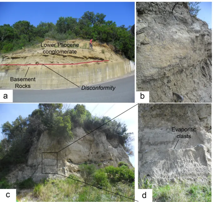
The early Pleistocene unconformity the (EPSU; Zecchin et al., 2012, 2015) marks the opening of the Catanzaro fault-bounded palaeo-strait (sensu Longhitano et al., 2012, 2014). The EPSU separates the fine-grained Pliocene deposits from the Calabrian strait-fill succession, consisting of ca. 100 m mixed silici-bioclastic sands, sandstones and, subordinately, mudstones (Fig. 3.13; Chiarella et al., 2012a; Longhitano et al., 2014).
Figure 3.13: Plio-Pleistocene Uncomformity (EPSU; Zecchin et al., 2015) bounding the top of Pliocene marls and limestones.
Mixed sediments derive from the combination of an extrabasinal (siliciclastic) with an intrabasinal (bioclastic) fraction (Chiarella, 2011). The lower Pleistocene stratigraphic interval includes the Vena di Maida, the Pianopoli and the lowermost interval of the Basile Unit. These units consist dominantly of mixed, fine to coarse-grained sandstone and, subordinately, mudstone.
The two sandstone units present varied internal organization and their heterogeneity differ based on the occurrence of small to medium trough (3D) cross-strata in the Vena di
Maida unit, and planar (2D) cross-strata in the Pianopoli unit (Fig. 3.14; Chiarella et al., 2011, 2012a; Longhitano et al., 2014).
Figure 3.14: a) Tidal deposits showing foresets organized in trough cross-strata close to Girifalco Village, b) and 3D cross-stratified sands outcropping near Pianopoli villagec) detail imaging likely bedform along the current
tidal cross-stratification
Near San Pietro a Maida village we can observe a very short outcropping which shows a 5 m thick calcarenites, characterized by the presence of balanus, corals and ostreas, without cross-stratification. The sedimentary sequence overlies Polia Copanello Unit and part of Lower Pliocene conglomerates (Fig. 3.15).
Figure 3.15: a) Calcarenites characterized by the presence of balanus, corals and ostreas, b) inclined stratification visible along the outcropping.
3.3.4 Middle-Upper Pleistocene Terrace sequence
The marine terraces distribution both in space and in time still ongoing debated: Tortorici et al. (2003) focused their studies on chronology and on the evaluation of the rates of uplift and, recognized seven distinct order of Capo Vaticano marine terraces. This study was supported by numerical dating derived from Optically Stimulated Luminescence (OSL) age estimates(Bianca et al., 2011). Their number and their distribution are very different from those reported in the Miyauchi et al. (1994) and Cucci & Tertulliani (2006) studies, both of them distinguished 12 orders of marine terraces.
The Marine terraces, mainly widespread along the Tyrrhenian coastline (Capo Vaticano promontory, Capo Suvero area and Costal Range), consist of a Middle-Late Pleistocene flight of wave-cut surfaces and/or thin-depositional platforms. Usually, they are bounded landwards by well developed inner edges representing the paleoshorelines related to the main sea level highstands (Tortorici et al., 2003).
The Quaternary terraced deposits are generally made up of siliciclastic sands and coarse sandstones with a fossiliferous content mostly represented by poor microfaunas. Even if rarely, within of these sequences, levels of gravel and boulders are observable (Fig. 3.16).
Figure 3.16: a) Erosional contact between Lower Pleistocene biocalcarenites and sand-wave deposits and Middle Upper Pleistocene Marine Terrace, b) Outcropping of Middle Upper Pleistocene Marine Terrace.
Within the Western Catanzaro Trough we have recognized at least six of the seven order of marine terraces, using the classification of Bianca et al. (2011) and Tortorici et al. (2002). The mapping of these morphological features allowed us to define a summit surface (Bianca et al., 2011) represents the highest and oldest order of the Middle-Upper Pleistocene marine terraced sequence. The eroded top surface reach the 700 m high both within the Serre Massif and the Capo Suvero area (Fig. 3.17). The Terrace VII, the lowest order of marine terraces, ascribed to the stage 3.3 (60 kyr) of the eustatic curve (Tortorici et al., 2002, 2003), is not observed in the area. The Terrace IV has been related to the OIS 5.5 (125 kyr) using TL age estimations (Balescu et al., 1997), widespread both within southwestern studied and Capo Suvero areas.
Figure 3.17: Northwestern overview of Catanzaro Trough, showing various order of terraces in the Capo Suvero area, bordered in the inner edge by NW-SE normal faulr.
3.3.5 Late Quaternary sequence
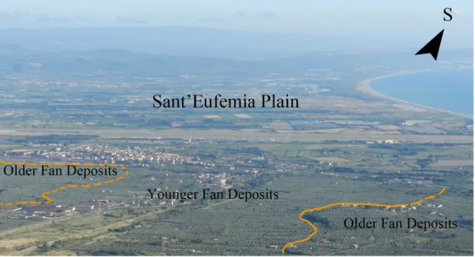
A western part of the Catanzaro Trough is characterized by a widely outcropping Late Quaternary sedimentary sequence. A detailed record (well logs) of the Late Quaternary geologic formations have been obtained by several borehole placed within Sant’Eufemia Plain (Fig. 3.18).
Figure 3.18: N-S overview of Sant’Eufemia Plain, showing two order of fan deposits, related to Upper Pleistocene-Holocene time
The Sant’Eufemia Plain is characterized by alluvial fans. The boreholes show, on average, 60m thick conglomerates and sands deposits, with subordinately silts layers, covering directly Middle Pleistocene clay.
Morphologically we recognized at least two order of fan deposits, mainly developed along the northern edge of the plain (Tortorici et al., 2002). To the south of Capo Suvero area, older alluvial fans is cut by a likely fault escarpment, representing the WNW-ESE normal Zinnavo Fault (Tortorici et al., 2002), which may have subsequently been rapidly buried by younger alluvial fans (Fig. 3.17).
We recognized at least three wide alluvial fans, one of these, the widest, is placed south of Nicastro, reaches the length of about 10 km. Close to the Tyrrhenian coastline, the last two reach the length of about 7 km. All of them are cut newly by very recent fluvial deposits. We integrated these insights with a set of old and new sub-surface data, which we amply treated in the next chapter.
CHAP. 4 Structural data
4.1 Structural analysis
The Catanzaro Trough is characterized by a complex geo-structural history. To gain knowledge of structural features of this region, we focused on analyzing of new structural datasets collected along the onshore segment of Catanzaro Trough. Further, new data, related to the main faults system, have been integrated with the interpretation of aerial photos, collected during photogrammetric surveys conducted in 1983 (scale 1: 33000) and, in 1990 (1:33000) by the Italian Military Geographic Institute (IGM) in Florence.
The collected structural data, related to the brittle elements and classified on the base of kinematics and fault directions, helped us to define the stress field of the whole study area. The distribution of more than 700 structural measurements, organized in about 40 survey stations (Fig. 4.1), have been analyzed and processed by using the DAISY software (Salvini, 2002). To better understand the tectonic evolution of the area data have been organized in two
structural domains, one of which characterizing the northern portion of Catanzaro Trough:
extending from Capo Suvero area to Corace River and the other one represented by the remaining southern domain: extending from Curinga to Girifalco villages (Fig. 4.1).
The statistical distribution of faults, here analyzed, has been further studied through contouring of the fault planes, slickensides and rotational axes (rotaxes).
The obtained datasets gave the opportunity to reconstruct major lineaments of the area. Where the fieldwork study and aerial photo interpretation become lacking, we integrated the acquired datasets by means of onshore seismic reflection profiles, treated widely in the next section.
A synthesis of location of geological and structural map are shown in figure 4.1. within the sketch map, the uncertain faults are marked by dashed red lines. The uncertainty is due to the difficulties to define the lineaments come from poor geological exposure and lack of clear evidence above Upper Pleistocene- Holocene sediments rarely recording the recent tectonic phases.
Figure 4.4: Structural and geological sketch map, the datasets have been organized in two structural aerial domains (grey boxes).
4.1.1 Rotational axis (rotaxes)
The rotaxes are structural elements which correspond to the σ2 axis of a conjugate pair
of faults, andersonian coniugate faults, used to discriminate between different deformation events (Wise & Vincent, 1965; Salvini & Vittori; 1982, Mattei et al., 1999).
The rotaxes (Fig. 4.2) show in the studied area two main sub-horizontal and sub-vertical clusters, even though we can notice a heterogeneous dispersion of rotaxes. The sub-horizontal rotaxes of normal faults dominate (almost 300 measurements) and are concentrated around the N30 and N70 directions (Fig. 4.2). These clusters are mainly related to N–S and NE–SW normal fault systems, corresponding to an extensional direction (σ3) mainly WNW-ESE
Although the number of measurements are less notable than normal faults, the sub-horizontal rotaxes (σ2) related to reverse faults (Fig. 4.2) show a greater concentration around
N45 direction, whereas σ1 is oriented along NW-SE direction.
The sub-vertical grouping of rotaxes is related to strike-slip faults, but they provide few information about the related conjugate fault systems; therefore, we preferred focused the analysis on the statistical distribution of orientation and kinematics of fault planes, described in the following section.
Figure 4.2: Contours of the rotaxes used to discriminate between different deformational events.
4.2 Northern structural domain
The main tectonic lineaments characterizing the northern margin of the area, clearly visible on the macroscale, are represented by transversal faults spanning from NW-SE to ca E-W orientation (Van Dijk et al., 2000; Tansi et al., 2007, Milia et al., 2009). These structural lineaments correspond partially to the southern fault segments, named Lamezia-Catanzaro Fault (sensu Tansi et al., 2007), belonging to the three right-stepping en ‘echelon major S-dipping fault segments.
Along the western portion of the northern area, these transversal fault systems act as high angle tectonic contact between the basement rocks belonging mainly to the Paleozoic Metapelitic and Mesozoic Carbonate units and, the overlying Late Quaternary deposits (Fig. 4.3). These lasts are located widely on the hangingwall of the main faults, causing unfortunately several limitation to define chronologically the kinematics in this margin.
Figure 4.3. Overview of northwestern margin of the Catanzaro Trough.
The geologic features is complicated both by the presence of inversion tectonics, likely due to local transpressional character of the main WNW- ESE faults and, by the activity of Quaternary NE-SW oriented normal faults. These lasts produce the exhumation of buried Early Miocene overthrusting contact between the Metapelitic Units above the Mesozoic Carbonate Unit. This contact outcrop within the Terme di Caronte area, showing a ca E-vergence and a ca W-dipping thrust plane (Fig. 4.4).
Figure 4.4: Overthrusting contact between the Ophiolitic and Metapelitic units above Mesozoic Carbonate Unit, close to Lamezia Terme town.
Towards eastern part of the northern margin, the WNW-ESE structures show a minor fault offset, indeed, the morphological escarpments, characterized by triangular and trapezoidal facets, become less visible than the western one. The outcropping sedimentary
succession is characterized by Messinian to Late Quaternary age, that allowed us to better analyzed events that influenced this area.
During the first opening phases of the Catanzaro Trough, the bed attitude of the strata show a general S-dipping of former depositional sequences related to Upper Messinian – Pliocene sediments. The Quaternary deposits shows W-dipping layers, in the western side, and E-dipping in the eastern side. This changing occur approximately along the center of the Catanzaro Trough which is characterized by a structural high, acting as a ridge or bedload parting (Longhitano et al., 2013, 2014). This elongated promontory connects the northern with the southern margin of the basin. The lateral continuity is further modified by faults with different direction and age and by the landslides that overturn part of the sedimentary sequences.
4.2.1 Structural data
Structural data analysis of brittle elements, classified on the base of kinematics, i.e. fault directions (DAISY software; Salvini, 2002), allowed to identify several fault sets with different strike and dip. Furthermore, we distinguished two types of substratum dislocated by the faults, that are: the Paleozoic-Mesozoic basement rocks, clearly recording the tectonic events of the Catanzaro Trough; and the Neogene-Quaternary sedimentary deposits that provide clues on chronological evolution of the area.
The northern Catanzaro Through is characterized by above mentioned morphological fault scarp, spanning from NW-SE to E-W direction.
At the mesoscale the structural data document the high distribution of ca. E-W oriented normal faults, widespread in the northwestern portion of the area, clearly offsetting the basement rocks.
As regards sedimentary units, the normal faults show a relative abundance compared with the other kinematics, affecting mainly Messinian to Pliocene deposits (Fig. 4.5). As consequence these lineaments seem to play an important role in the general N-S oriented extensional axis, which drove the Catanzaro Trough opening during late Miocene (see below in figures 4.18b and 4.19b).
Figure 4.5: E-W faults system classified on the base of the kinematics, direction and type of substrate.
Although at the regional scale, NW- SE fault system represents the boundaries of the transtensional deformation zone. The collected structural data show a poor distribution in terms of structural measurements, both as regards basement rocks and Miocene- Quaternary deposits.
The northern paleostrait deposits are not marked by left lateral faults, at least to the mesoscale, whereas right-lateral strike slip faults affect both basement rocks and deposits (Fig. 4.6).
Although the structural data show a differentiated distribution of faults, the NE-SW oriented faults system represent the more widespread measurements in the northern area (Fig. 4.7).
The NE-SW normal faults, characterized by a significant preponderance of oblique slickensides, usually overprint pre-existing kinematic indicators and former fault system. The
WNW-ESE extensional axis driven by the NE-SW normal faults produced a Pleistocene basin subsidence and deepening of the western portion of Catanzaro Trough and the general uplift of adjacent crystalline basement.
Relatively abundant are the left- and right- lateral faults registered both from basement rocks and deposits. The same NE-SW transcurrent faults take on locally transpressional and transtensional features.
Figure 4.7: NE-SW faults system classified on the base of the kinematics, direction and type of substrate
Close to the Marcellinara area, the Messinian conglomerates are dislocated by syn- sedimentary strike slip faults with a reverse component of motion (Fig. 4.8).
The NE-SW faults represent, especially during the Pliocene age, conjugate structures controlled by the major NW-SE transcurrent system. Within Catanzaro Trough, the NE-SW fault system influence, the ongoing drainage pattern of the main river in the area (the Amato River) and other minor NE-SW orientated streams.
Figure 4.8: NE-SW transpressional faults outcropping above the Messinian conglomerates(visto il basso angolo forse è meglio parlare di thrust
In the northern side of Catanzaro Trough, we measured an high number of N-S faults, affecting both basement rocks and deposits. These structural data have been collected mainly within and close to the Bagni and Corace rivers, which show both of them a N-S stream trend, although two watercourses are placed at a distance of about 20 km from one another, in the western and eastern margin of the study area, respectively. Towards east the Corace River, close to Catanzaro City N-S straight trend. The N-S transcurrent faults collected above sedimentary units shows a relative abundance as regards right lateral faults compared the other (Fig. 4.9).