ALMA MATER STUDIORUM
UNIVERSITÀ DEGLI STUDI DI BOLOGNA
FACOLTÀ DI SCIENZE MATEMATICHE, FISICHE E NATURALI
Dottorato di Ricerca in
Scienze Ambientali: Tutela e Gestione delle Risorse Naturali
Ciclo XXIV
Settore concorsuale di afferenza: 04/A1
Settore scientifico disciplinare: GEO/08 Geochimica e vulcanologia
EFFECTS OF RESOURCES EXPLOITATION ON
WATER QUALITY:
CASE STUDIES IN SALT WATER INTRUSION
AND ACID MINE DRAINAGE
Tesi Presentata da: Dott. ssa Martina Kralj
Coordinatore Dottorato:
Tutore: Prof. Enrico Dinelli
Prof. Enrico Dinelli
Relatore: Dr. Massimo Marchesi
INDEX
Preliminary remarks ... 1
Premessa ... 2
Salt Water Intrusion (SWI) ... 3
Acid Mine Drainage (AMD) ... 5
References ... 6
Abstract ... 7
PART I ... 8
Groundwater chemistry and arsenic occurrence in the phreatic aquifer system of the San Vitale pine forest ... 9
Abstract ... 9
General context, materials and methods ... 10
Introduction ... 10
Outline and objectives of the study ... 10
Study area ... 11
Background ... 11
Geological setting ... 13
Hydrogeology ... 14
Materials and methods ... 16
Sampling ... 16
Results and discussion ... 19
Water table and fresh-‐ salt-‐ water interface ... 19
Chemical characterization ... 21
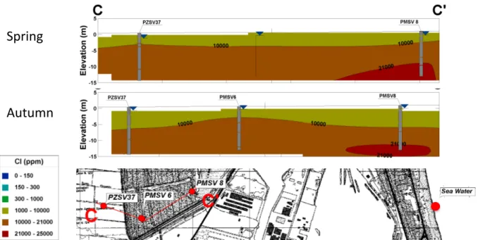
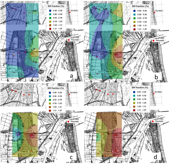
Quantification of sea water intrusion ... 28
Salinization/ freshening and related water rock interactions ... 30
Ion exchange ... 30
Seasonal variations ... 32
Stuyfzand water classification ... 35
Arsenic occurrence ... 38
Conclusions ... 41
References ... 43
PART II ... 49
Aqueous and sediment geochemistry of acid mine drainage in the San Juan de Sora Sora basin (Bolivia) ... 50
Abstract ... 50
General context, materials and methods ... 51
Introduction ... 51
Outline and objectives of the study ... 52
Study Area ... 53
Geomorphologic framework ... 53
Hydrology and climate ... 57
Ore geology ... 58
Vegetation and land use ... 59
Mine activities in the area ... 60
Materials and methods ... 62
Sampling ... 62
Water samples ... 64
Solid fraction ... 65
Geochemical characterization of waters ... 67
Physical parameters ... 67
Chemical parameters ... 71
Seasonal variation of the mining related contaminants ... 74
Surface and ground-‐water interactions ... 83
Geochemical characterization of Sediments ... 85
Total sediment composition ... 86
Sequential extractions ... 93
Water -‐ Sediment Interactions ... 99
Conclusions ... 101 General conclusions ... 103 References ... 104 Ringraziamenti ... 112 Annex I ... 113 Annex II ... 118
Preliminary remarks
Groundwater and surface water are the most used reservoirs by humans for water supply, especially because of their accessibility. Its vulnerability depends on a combination of natural landscape features, such as geology, topography, and soils; climate and atmospheric contributions; and human activities related to different land uses and land-‐management practices. The evaluation of the water quality, defined by its chemical, physical and biological characteristics in respect to its suitability for a particular purpose, require the identification of the interconnections among surface water and ground water, atmospheric contributions, natural landscape features, and human activities.
Throughout the world, pressures on water resources are increasing, mainly as a result of human activity. Urbanisation, population growth, increased living standards, growing competition for water, industrial development, agricultural activities and mining enterprises are some of the causes of water contamination.
Groundwater and surface water contrasts markedly in terms of the activities and compounds that cause pollution. In addition, there are completely different controls that govern the contaminant mobility and persistence in the two water systems’ settings. Groundwater is less vulnerable to human impacts than surface water. However, once polluted, cleaning it up takes a relatively long time is more technically demanding and can be much more costly. Moreover, surface water is hydraulically connected to ground water in most of the cases, therefore it is important to consider ground water and surface water as a single resource.
The objective of this research is to characterize two different cases of water pollution: a saltwater intrusion contamination in a costal aquifer, and the impact of acid mine drainage on a river basin, considering surface and groundwater.
• The first chapter focus on the geochemical characterization of a shallow coastal aquifer affected by saltwater intrusion in the San Vitale pine forest near Ravenna (Italy). Many factors are responsible for the salinization of the area in particular the overexploitation of the aquifer for irrigation use and the subsidence of the examined area, attributed to natural (sediment compaction) and anthropic (natural gas exploitation) causes.
• The purpose of the second case study was the examination of the impact of acid mine drainage on the surface-‐ and ground-‐ waters in the San Juan de Sora Sora River basin in Bolivia. The characterization of waters and sediments was performed in order to determine the influence of a tin-‐extraction mine on water quality, in an area considered among the world richest in ore deposits.
Premessa
La struttura originale di questa tesi è dovuta al fatto che durante il periodo di ricerca, non avendo potuto usufruire di una borsa di studio che mi permettesse di intraprendere un cammino lineare, sono stata spinta a cercare progetti diversi, già attivi e con fondi disponibili, assieme ad altri finanziamenti personali. La borsa di studio Marco Polo mi ha permesso di partecipare a diversi progetti in Spagna, da cui poi è iniziato, grazie anche al finanziamento successivo, il programma Erasmus Mundus, il progetto svolto in Bolivia, apparentemente molto ‘lontano` dal primo studio, una ricerca svolta invece nella provincia di Ravenna. Entrambe queste esperienze mi hanno permesso di entrare in contatto con realtà molto diverse e molto lontane fra loro, dalle quali ho cercato di ricavare un’unitarietà e un filone comune, in quanto tutte riconducenti al deterioro di una risorsa preziosa come l’acqua, quest’ultima senza confini.
Nella certezza dell’unicità di questo bene insostituibile, mi ritengo fortunata per avere avuto la possibilità di scoprire come questa risorsa venga vissuta in realtà così diverse dalla nostra quotidianità, e quanto sia prioritaria e importante la sua salvaguardia. Questa premessa mi sembra indispensabile per capire l’analisi che propongo, nata al di fuori dei consueti percorsi previsti per una ricerca di dottorato.
Salt Water Intrusion (SWI)
Water quality for coastal aquifers is nowadays a global scale problem, since a large portion of the population uses this resource as supply of fresh water. Saltwater intrusion is the major concern commonly found in coastal areas, reducing the availability of groundwater resource. At present, many coastal aquifers in the world, especially the shallow ones, are affected by intensive saltwater intrusion caused both by natural and/or human-‐induced processes. The problem is intensified by the population growth, and by the increasing use of coastal areas, especially during summer, by tourism industry (70% of the world population occupies the coastal plain zones) (Vengos, 2003).
Saltwater intrusion is defined as an induced flow of seawater into freshwater aquifers, primarily caused by groundwater development near to the coast. When groundwater is pumped from aquifers in hydraulic connection with the sea, an induced gradient is generated, with a consequent migration of salt water from the sea toward the aquifer, and finally into the wells. Because fresh water is less dense than salt water, it tends to floats on top. The boundary between salt water and fresh water is not distinct; the zone of dispersion, transition zone, or salt-‐water interface is brackish with salt water and fresh water mixing.
Under normal conditions fresh water flows from inland aquifers and recharge areas, finally discharging to the sea, from the areas with higher water table (WT) level to areas with lower WT level. This natural movement of fresh water towards the sea prevents salt water intrusion in coastal aquifers (Barlow, 2003).
Figure 1: ground-‐water overexploitation and salt water intrusion in Europe ( Source EEA, 1999).
• Lateral encroachment from the ocean due to excessive water withdrawals from coastal aquifers, or
• Upward movement from deeper saline zones due to upconing near coastal discharge/pumping wells.
Saltwater intrusion into freshwater aquifers is influenced also by factors such as tidal fluctuations, long-‐term climate and sea level changes, fractures in coastal rock formations, change of land use and land management practice, seasonal changes in evaporation and recharge rates (Barlow, 2003).
Saltwater has high concentrations of total dissolved solids and other inorganic constituents, becoming unfit for human consumption and many other anthropogenic uses. Saltwater intrusion reduces fresh ground-‐water storage and, in extreme cases, leads to the abandonment of supply wells when concentrations of dissolved ions exceed drinking-‐water standards (U.S. Geological Survey, 1999).
Remarkable is the difference between the chemical composition of the saline water, associated with salt-‐water intrusion, and the theoretical mixture of seawater with groundwater (Jones et al., 1999). These geochemical modifications for seawater intrusion have been attributed mainly to base-‐exchange reactions with the aquifer materials, typically, clay minerals, organic matter, oxy-‐ hydroxides, and fine-‐grained rock materials (Vengos, 2003).
In order to manage coastal groundwater resources, the study of movement, mixing and interaction between freshwater and saltwater, as well as the parameters which influence these processes is necessary. Nowadays, detailed studies on saltwater intrusion have become necessary in designing and planning groundwater systems exploitation in coastal areas.
Acid Mine Drainage (AMD)
Human activities such as mining threaten the water sources on which we all depend. There is growing awareness of the environmental legacy of mining activities that have been undertaken with little concern for the environment. Mining consumes, diverts and can seriously pollute water resources through heavy use of water in processing ore, and through water pollution from discharged mine effluent and seepage from tailings and waste rock impoundments.
Acid Rock Drainage (ARD) is a natural process whereby acidity is produced when sulphides in rocks are exposed to air and water. Acid Mine Drainage (AMD) is essentially the same process, however greatly magnified. Although this process occurs naturally, mining can promote AMD generation through the mine tailings and waste rock product, which due to their smaller grain size, have much greater surface area than in-‐place geologic material (Jennings et al., 2008). Characterized by low pH and high concentrations of heavy metals and other toxic elements, AMD can severely contaminate surface and ground-‐ water, and soils as well.
Generally the recovery of metals from sulphide-‐rich ore bodies proceeds through a series of steps from mining, crushing, and mineral recovery, followed typically by smelting of the sulphide ores, and thence to metal refining. Although the nature of the ore body dictates the processes used to extract metals from ore, each of these steps generates a waste stream. The oxidation of sulphide minerals in these waste materials (mostly pyrite and pyrrhotite) released elements such as aluminium, arsenic, cadmium, cobalt, copper, mercury, nickel, lead, and zinc to the water flowing through the mine waste (Blowes et al., 2003).
Metal contamination associated with AMD depends on the type and amount of sulphide mineral oxidized, as well as the type of minerals present in the rock. The acid generation is a complex process which requires the presence of:
• Sulphide materials
• Water or a humid atmosphere
• an oxidant, particularly oxygen from the atmosphere or from chemical sources Additionally, bacteria in the majority of cases play a major role in accelerating the rate of acid generation (Akcil and Koldas, 2006). The acid will leach from the rock as long as its source rock is exposed to air and water and until all the available sulphides are leached out. This process can last hundreds, even thousands of years. Acid is carried off the mine site by rainwater or surface drainage and deposited into nearby streams, rivers, lakes and groundwater.
Despite the various options available for remediating, preventing is considered to be the better option. This is not feasible in many locations and in such cases, it is necessary to collect, treat, and discharge mine sediments. For a responsible management of the sediments, use of selective sequential extraction analysis is a developing tool, in the prediction of the potential effects of metal contamination in changing environmental conditions.
References
Akcila A., & Soner Koldas S. (2006). Acid Mine Drainage (AMD): causes, treatment and case studies, Journal of Cleaner Production 14(12–13), 1139–1145.
Barlow, P. M. (2003). Groundwater in Freshwater-‐Saltwater Environments of the Atlantic Coast. U.S. Geological Survey Circular: 1262.
Blowes, D.W., Ptacek, C.J., Jambor, J.L., & Weisener, C.G. (2003). The geochemistry of acid mine drainage. In: Lollar, B.S. (Ed.), Environmental Geochemistry. Treatise on Geochemistry,vol. 9. Elservier–Pergamon, Oxford, 149–204.
EEA (1999). Groundwater quality and quantity in Europe. Environmental assessment report No 3. European Environment Agency. Copenhagen.
Jennings, S.R., Neuman, D.R., & Blicker, P.S. (2008). Acid Mine Drainage and Effects on Fish Health and Ecology: A Review. Reclamation Research Group Publication, Bozeman, MT.
Jones B. F. (1965). Geochemical evolution of closed basin water in the western Great Basin. In Second Symposium on Salt (ed. J. L. Rau). Northern Ohio Geol. Soc. vol. 1, 181–200.
Nordstrom, D.K. (1982). Aqueous pyrite oxidation and the consequent formation of secondary iron minerals, In: Kittrick, J.A., Fanning, D.S. and Hossner, L.R., eds. Acid sulfate weathering. Soil Science Society of America, 37-‐63.
Vengos A. (2003). Salinization and saline environment. In: Lollar, B.S. (Ed.), Environmental Geochemistry. Treatise on Geochemistry,vol. 9. Elservier– Pergamon, Oxford, 333–365
Abstract
Throughout the world, pressures on water resources are increasing, mainly as a result of human activity. Because of their accessibility, groundwater and surface water are the most used reservoirs. The evaluation of the water quality requires the identification of the interconnections among the water reservoirs, natural landscape features, human activities and aquatic health.
This study focuses on the estimation of the water pollution linked to two different environmental issues: salt water intrusion and acid mine drainage related to the exploitation of natural resources.
Effects of salt water intrusion occurring in the shallow aquifer north of Ravenna (Italy) was analysed through the study of ion-‐ exchange occurring in the area and its variance throughout the year, applying a depth-‐specific sampling method. In the study area were identified ion exchange, calcite and dolomite precipitation, and gypsum dissolution and sulphate reduction as the main processes controlling the groundwater composition. High concentrations of arsenic detected only at specific depth indicate its connexion with the organic matter.
Acid mine drainage effects related to the tin extraction in the Bolivian Altiplano was studied, on water and sediment matrix. Water contamination results strictly dependent on the seasonal variation, on pH and redox conditions. During the dry season the strong evaporation and scarce water flow lead to low pH values, high concentrations of heavy metals in surface waters and precipitation of secondary minerals along the river, which could be released in oxidizing conditions as demonstrated through the sequential extraction analysis. The increase of the water flow during the wet season lead to an increase of pH values and a decrease in heavy metal concentrations, due to dilution effect and, as e.g. for the iron, to precipitation.
PART I
Groundwater chemistry and arsenic
occurrence in the phreatic aquifer system of
the San Vitale pine forest
Abstract
Groundwaters quality of the shallow phreatic aquifer of the San Vitale pine forest in Ravenna (Italy) is severely affected by coastal saline intrusion. Fifteen piezometers were sampled at various depths using a staddle parker system, during spring, summer and autumn seasons in order to understand the geochemical processes occurring close to the freshwater/saline interface and its variations during the year. Sea water fraction, ionic deltas and saturation index were investigated to characterize the hydrogeochemical features of the aquifer in the area. The Water table level lies mostly below sea level, consequently there is no natural freshwater hydraulic gradient contrasting the density gradient of the saltwater. The depletion on Na+ indicates a
salinization process in the eastern part of the aquifer and in the deeper waters, confirmed by the Base EXchange index (BEX) calculated through the Stuyfzand method. Cation exchange, dolomitization, gypsum dissolution and sulphide reduction were identified as operating in the aquifer.
Additionally, the presence of Arsenic was investigated as most of the sampling wells exceeding the arsenic concentrations currently Italian legal maximum contaminant level (10 μg/l). The amounts of dissolved arsenic in the groundwater are related to a layer rich in organic matter, and correlate along the depth with the concentrations of Fe2+,
General context, materials and methods
Introduction
When considering the water resources in areas bordering seas, coastal aquifers are important sources of fresh water. Since groundwater systems in these areas are in contact with saline water, one of the major environmental problems might be saltwater intrusion, which can reduce the available fresh groundwater resources in coastal aquifers. At present, many coastal aquifers in the world, especially shallow ones, experience an intensive saltwater intrusion caused by both natural and human-‐induced
processes. The European Environment Agency has recognized that the problem of
saltwater intrusion due to groundwater over-‐exploitation is one of the major threats to coastal area freshwater resources in Europe, and Italy especially, with its 8500 km of coastline, has been indicated as one of the most critical countries (Scheidleger et al.,
2004). Many studies in Italy shows that freshwater resources are becoming increasingly
scarce from intense use, salinization and long periods of drought, not only for the loss of drinking water supply, but also for the effects on natural vegetation, ecosystems, wetlands and salinization of agricultural soils in the coastal zone (Antonellini et al., 2008; Barrocu et al., 2001; Cau et al., 2002; Capaccioni et al., 2005; De Luca et al., 2005; Doveri et al., 2010; Giambastiani et al., 2007; Polemio et al., 2010; Pranzini, 2002). Costal aquifer salinization consists, from a geochemical perspective, of a high-‐salinity solution (seawater) mixing with a dilute solution (fresh water) in a medium that has especially reactive minerals. When this salt-‐water/fresh-‐water mixing occurs, processes like cation exchange contribute significantly to the final composition of the groundwater.
Outline and objectives of the study
The aims of this study were to:
ü determine the influence of the water table on the salt water intrusion occurrence
ü characterize geochemically the groundwaters of the pine forest and its variability
in relation to the seasonality
ü determine the intensity of the salinization processes
ü study the water rock interactions related to the salinization/freshening of the aquifer
Study area
Background
The San Vitale pine forest is situated 3 to 5 km west of the Adriatic Sea on a dune belt system within the Po Plain in northern Italy. The area is particularly affected by several natural and anthropogenic features such as: land subsidence; saltwater intrusion in the phreatic aquifer and seawater encroachment inland along the rivers; direct contamination from water bodies open to the sea; destruction of coastal dunes and reduction of their barrier effect; land reclamation drainage systems; insufficient aquifer recharge and sea level rise.
The natural subsidence rate, due to the compaction of alluvial deposits, is approx. 1 mm/year (Selli and Ciabatti, 1977; Pieri and Groppi, 1981), however in the last century the main topographical variation of the area has been due to anthropogenic subsidence. Land settlement, dramatically increased the subsidence rate up to 110 mm/year after World War II, primarily due to groundwater pumping and, subordinately, gas winning from a number of deep on-‐shore and off-‐shore reservoirs (Teatini et al., 2006). Nowadays, subsidence rate has declined down to 1 cm/year. Land subsidence has dropped most of the territory below mean sea level, modifying the river and normal groundwater flow regimes. A drainage system is necessary primarily to lower the phreatic level and keep the agricultural land dry, together with keeping tree roots in the coastal areas above the watertable. However, the result of the drainage system management is an unstable phreatic level in the aquifer, which is not able to contrast saltwater intrusion and saline and brackish groundwater are intruding landwards. Therefore this consequence is far from helping to maintain the Pine forest ecosystem, which is very sensitive to salinity of the water.
The San Vitale pine forest represents an historical landmark in the Po River Plain. It extends north– south for 10 km, beginning north of Ravenna, over an area of about 16.6 km2 (Figure 1). It is bounded by the Destra Reno Channel to the north, by the scolo
Canala and Staggi to the south and by the Piallassa Baiona to the east. It is finally bounded by a complex system of drainage channels connected with the Via Cerba drainage-‐pumping machine on the west. The entire San Vitale area is part of the Delta Po natural park.
Planted by monastic communities between the 10th and 15th century (Giambastiani et al., 2007), the pine forest is nowadays a popular tourist’s destination, especially for its historical value. The surrounding area underlies several economic interests; the urban area of Ravenna, industrial plants, agriculture, harbour activities and tourism.
San Vitale area is bordered in the northern part by a large swamp area, Punta Alberete, and by cropland to the south. Punte Alberete, for a total area of 189 ha, is protected by the Ramsar Convention being a valuable wetland and hosting rare bird species, which makes this place a famous tourist attraction for bird watching. The woodland established in this part is seasonally flooded by adjoining Lamone river (SEHUMED, 2000).
PZSV18' PZSV17' PZSV13'PZSV14' PZSV26' PZSV23'PMSV7'PZSV30' PZSV37' PMSV8' PMSV6' SCOLO% CANALA% STAGGI%C HANNE L% LAMON E%RIVE R% PIALLASSA% BAIONA% PUNTE% ALBERETE% VIA%CERBA% CHANNEL% Drainage%pumping% machine% Wells% FOSSATONE% CHANNEL% Chiaro' Pontazzo' Chiaro'' Risega' Chiaro'' Di' mezzo' Taglio' Baiona' Chiaro' Comune' Sea'Water' Piallassa%Baiona% San%Vitale%pine%forest%
Figure 1: Location map of San Vitale pine forest and Punte Alberete swamp (green) and the Biallassa Baiona (blu) adjacent to the Adriatic coastline north of Ravenna (Po Plain, Italy). Red dots indicate the sampled wells and the yellow one the drainage pumping machines.
Geological setting
The Romagna coastal plain, where the San Vitale pine forest is located, comprises the southeastern part of the wider Po River Plain. The Po Plain covers an area of roughly 70,000 km2 enclosed between the Alps to the north and Apennines to the south. These
two chains supply the Po basin with continental sediments of heterogeneous composition. Those derived transported from by the Po River are a complex mixture of many rock types, with the important provenance signal of high contribution of ophiolitic rock (Amorosi et al., 2002). The contribution from the apenninic chain is dominated from contribution deriving from the erosion of the Marnoso-‐arenacea formation a thick flysch unit with abundant carbonate contribution. The uppermost aquifer is however related to a coastal environment of deposition, so contribution from other sources (especially to northern Adriatic ones enriched in dolomite) can be present. The Ravenna study area, as part of the southeasternmost Po Plain fill, underwent severe alterations in its depositional environment. The sedimentation dynamic in the coastal area was prevalently controlled by climatic and eustatic fluctuations. During last glacial maximum the relative sea level dropped about 100 to 120 m in the Adriatic epicontinental plain (Van Straaten, 1970), shifting the shoreline 250 km south compared to its present position and thus, forming an alluvial plain. Marine as well as continental deposits from Late Quaternary cover marine sediments of Pliocene to Middle Pleistocene age (Amorosi et al., 1999).
Therefore, Pleistocene accumulation was basically driven by continental sedimentation (Curzi et al., 2006) of 4th order lowstand alternating with short-‐term transgressive periods (Amorosi et al., 2004). The continental sedimentation induced the deposition of alluvial facies, represented in Figure 2, (Amorosi et al., 1999), which consist of subfacies composed of silt to silty sands tending to coarsen upwards (Amorosi et al., 1999). These facies indicate subaerial exposure and are interpreted as floodplain sediments, levee or channel-‐fill deposits. Back-‐barrier deposits, accumulated during Holocene transgression when sea level rose sharply between 18000 and 6,000 BP overlies the alluvial facies. Initially (10500 to 9000 BP) still restricted to incised valleys, those transgressive sand and coastal plain deposits promoted the formation of shallow marine environments (Amorosi et al., 2002; 2003). During peak transgression (6000 to 5000 BP) these accumulations filled lagoons, swamps and marshlands further landward (Amorosi et al., 1999), as reflected by peats and muds enriched in organic carbon (Amorosi et al., 2002). As Stefani and Vincenzi (2005) point out, the years 3500-‐3000 BP were characterized by warm climate and stability in the riverine system. Under Roman intervention a vast stable hydraulic system was established meanwhile the following cooler and moister period (approximately 1500 – 1300 BP) led to a distinct deposition as well as failures in the waterworks (Stefani and Vincenzi, 2005).
During the last 2000 years the fluctuations of the sea and the subsidence rates provoked movements of the coastline and the subsequent formation of beach ridges and submersion which create brackish marshes and lagoons in progradation with the littoral strip (Bondesan et al., 1995).
14
Figure 2: Stratigraphic cross-‐section of the coastal plain of Ravenna (Po plain, Italy), (Amorosi et al. 1999)
Hydrogeology
The aquifer system in the area is characterized by the stratigraphic architecture. Two prominent stratigraphic markers, corresponding to wedge-‐shaped coastal sand bodies, recorded between 0-‐30 m and 100-‐130 m borehole depths, are separated by a thick succession of mud-‐prone alluvial deposits (Figure 3). This sequence formed during the transgressive-‐ regressive cycles of Quaternary sedimentation is characteristic of the entire Adriatic coastal plain and can be traced parallel to the shoreline (Amorosi, 2008). These sandy successions identify the coastal aquifers; marked as particular saltwater induced as they derive from prograding delta and beach deposits accumulated during sea level highstand.
!"#$% &%'()*'+,-,./0'1$23456'789:;.<='>>=?>=:;3@2A2B"*C(D E F6G"H6% I
!"#$%&'(&! ()*( ()& #"*+(*, +*'!+ -&.& !&/"+0(&! $'!&. * /.&!"%0'*'(,1 2,*#0"3&$+(*(0# 4566 718 #"'(.", !$.0'2 ()& ,*+( (-" %*9". (.*'+2.&++0:& /$,+*(0"'+ *'! +$;+&<$&'( +&*3,&:&, )02)+(*'!+= #"..&+/"'!0'2 (" >?@ 5 *'! A&= .&+/&#(0:&,1 4B%"."+0 &( *,C= D66E8C F' ()& "()&. )*'!= *,,$:0*, +&!0%&'(*(0"' (""7 /,*#& 0' * G*+(3+$;+0!0'2 +&(3 (0'2= !$.0'2 ()& +$;+&<$&'(= ,"'2 /)*+&+ "G +&*3 ,&:&, G*,,C
H)&+& (-" H3I +&<$&'#&+= -)0#) #"..&+/"'! (" I*:&''* *'! J0,,* J&.$##)0" +$;+1'()&%+ 0' ()& K&","20#*, >*/ "G ?(*,1= G".% ()& ;*+0# %"(0G "G ,*(& L$*(&.'*.1 +&!0%&'(*(0"' 0' ()& &'(0.& B!.0*(0# #"*+(*, /,*0'= *'! #*' ;& &*+0,1 (.*#&! /*.*,,&, (" ()& +)".&,0'&= G."% I*:&''* (" ()& M" N&,(* 4B%"."+0 &( *,C= D66EO P"'!&+*' &( *,C= D66Q8C M*.(0#$,*.,1= ()& H1..)&'0*' 4>?@ A&8 #"*+(*, +*'! ;"!1 0+ 0!&'(0G0&! *( /."2.&++0:&,1 ,"-&. !&/()+ '".() "G ()& M" N&,(*= 0'(" ()& +$;3 +$.G*#& "G ()& J&'&(0*' *'! R.0$,0*' #"*+(*, /,*0'+ 4R&..*'(0 &( *,C= D66Q8= ()$+ #"'G0.%0'2 ()& 0%3 /".(*'( .",& /,*1&! ;1 (&#("'0# +$;+0!&'#& 0' +)*/0'2 ()& M" P*+0' G0,, 4+&& *,+" S*.%0'*(0 &( *,C= D66T8C
I&/&(0(0:& *,(&.'*(0"' "G #"*+(*, *'! *,,$:0*, !&/"+0(+ 0+ /*.*,,&,&! ;1 * !0+(0'#(0:& /",,&' +023 '*($.&C M*.(0#$,*.,1= /",,&' !*(* !"#$%&'( * +(.0#( .&,*(0"'+)0/ ;&(-&&' H3I +&<$&'#& !&:&,"/%&'( *'! 566371 0'(&.2,*#0*,U2,*#0*, #1#,&+ 4R02C E8C B ,"'23#".&! /",,&' +&.0&+ G."% S".& DDT3@5V 4+&&
R02C T= G". 0(+ ,"#*(0"'8 )*+ .&#&'(,1 !"#$%&'(&! ()*( ()& (-" H@+ #"..&,*(& 0':*.0*;,1 -0() ()& "'+&( "G G".&+(&! #"'!0(0"'+ !$.0'2 0'(&.2,*#0*,+= -)&.&*+ .&($.' (" *,,$:0*, +&!0%&'(*(0"' #"..&3 ,*(&+ -0() *;.$/( #)*'2& (" *' "/&' :&2&(*(0"'= #)*.*#(&.0+(0# "G 2,*#0*, #"'!0(0"'+ 4B%"."+0 &( *,C= D66E8C
H)& ,"-&. /*.(+ "G ()& H3I +&<$&'#&+ G".% ()0' H@H+ 4R02C T8= +)"-0'2 #"*+(*,3/,*0' *23 2.*!*(0"' *'! .*/0! +)".&,0'& (.*'+2.&++0"' 4;*#7+(&//0'2 ;*..0&.3,*2""'3&+($*.1 +1+(&%+8C H.*'+2.&++0:& !&/"+0(+ *.& ":&.,*0' ;1 ()0#7&. +)*,,"-0'23$/-*.! +$##&++0"'+= 0'(&./.&(&! (" .&G,&#( !&,(* *'! +(.*'!/,*0' /."2.*!*(0"' 4W@H8C H)& %*X0%$% G,""!0'2 +$.G*#& )*+ '" ";:0"$+ /)1+0#*, &X/.&++0"'C ?( 2&'&.*,,1 "##$.+ -0()0' )"%"2&'&"$+ +)*,,"-3%*.0'& !&/"+0(+ 4R02C E8= *'! #*' ;& ,"#*,,1 !&(&#(&! "' ()& ;*+0+ "G +$;(,& %0#."/*,*&"'(","20#*, 0'!0#*(".+= -)0#) *,,"- ()& !0+(0'#(0"' ;&(-&&' ;*#7+(&//0'2 +)".&,0'&+ *'! /."2.*!0'2 !&,(* +1+(&%+ 4B%"."+0 *'! S",*3 ,"'2"= D66AO B%"."+0 &( *,C= 0' /.&++8C H)& Q6 %3 ()0#7 +$##&++0"' "G *,,$:0*, /,*0' !&/"+0(+ +*'!3 -0#)&! ;&(-&&' ()& (-" #"*+(*, +*'! ;"!0&+ 4R02C T8 !0+/,*1+ /",,&' +/&#(.* !0*2'"+(0# "G 2,*#0*, #"'!0(0"'+= *'! 0+ 0'(&./.&(&! (" .&G,&#( G*,,0'23 +(*2& 4R@H8 *'! ,"-+(*'! 4Y@H8 !&/"+0(+ 4B%"."+0 *'! S",*,"'2"= D66A8C
Z',07& 0(+ H1..)&'0*' #"$'(&./*.(+= -)&.& W","#&'& !&/"+0(+ %*1 ;& ,"#*,,1 *+ ()0#7 *+ A63V6 !"#$%"&'$%( &)*$+", ("-."',/ 0$'1$% & 2")*"%3" 2',&'$(,&41$3 +,&."0-,56 78$9"%3" +,-. '1" :*&'",%&,/ -+ '1" ;- <$8", =&2$%> ?-,'1",% @'&#/
n n in e s
Core 223-S12 Core 240-S13
9
Core 223-S17
Fluvial-channel sand Overbank fines Swamp/lagoon clay
Coastal sand Shallow-marine clay Transgressive surface
-100 -200m -50 -150 m 0 1 5e TST HST HST TST LST FST LST 10 km 0 !"#$ % & '()*") +,)"-. ,/)0"1-)12/- 3+ *,1- 42,1-/5,/( 6-73."1. 8-5-,10 10- 936-/5 :6/",1") )3,.1,* 7*,"5; <"10 ,#- ,11/"821"35 =>,/"5- ?.3137-@1,#-. A ,56 B-C 3+ )3,.1,* 6-73."1. ,56 .-D2-5)-&.1/,1"#/,70") "51-/7/-1,1"35$ E@EF E/,5.#/-.."G- @(.1-9. E/,)1; H@EF H"#0.1,56 @(.1-9. E/,)1; !@EF !,**"5#&.1,#- .(.1-9. E/,)1; I@EF I3<.1,56 .(.1-9. E/,)1$ !3/ .-)1"35 1/,)-; .-- !"#$ A$
Figure 3: Cross-‐section of the coastal sedimentary succession defining the aquifers. TST: Transgressive Systems Tract, HST: Highstand Systems Tract, FST: Falling-‐stage systems Tract, LST: Lowstand systems Tract (Amorosi, 2008).
The San Vitale aquifer comprises an unconfined system based upon beach and dune sandy deposits. Some lenses of clay and peat alter the hydrological setting into confined zones, particularly in swamp areas as they occur in the northwestern part of the San Vitale pine forest and Punte Alberete wetland.
The upper aquifer subsystem A1 is formed by two layers: a relatively thick medium-‐ grained sand shallow unit of 10 m (from 0 m to -‐10 m a.s.l.) and a lower fine-‐grained sand unit of a lesser thickness (from -‐21 m to -‐26 m a.s.l.) The two bodies are separated
by a clayey-‐silt and sandy-‐silt unit (from -‐10 m to -‐21 m a.s.l.). The Würmian continental silty-‐clay basement lies at a depth varying from -‐20 m in the western sector to -‐30 m at the present shoreline (Veggiani, 1971; 1974) (Figure 2). Since the sandy layer was deposited as dune and coastal sands its composition is relatively homogeneous and of high permeability. Antonellini et al. (2008) report hydraulic conductivities as high as 24.8 m/d for the San Vitale pine forest. The porosity varies from 0.15 to 0.35 (Giambastiani et al., 2007).
The climate of the area is characterized by moderate precipitation of 600-‐1000 mm/year (Figure 4) usually dominant during fall, with a maximum value in October and annual mean temperatures of 14.4°C. The aquifer is characterized by a low recharge rate of 14 mm/a due to the effect of high evaporation. The aquifer thickness varies between 3 m coastward up to 30 m in the most western part and it is on average 10 m. The amount of the aquifer volume is estimated as 60000 m3/m shoreline (Antonellini et al., 2008).
0" 20" 40" 60" 80" 100" 120" 140"
Jan+09" Feb+09" Mar+09" Apr+09" May+09" Jun+09" Jul+09" Aug+09" Sep+09" Oct+09" Nov+09" Dec+09"
Preci pi ta )o ns-( mm) - Months- Precipita)ons-2009-
Figure 4: Precipitations in mm in the year 2009 in San Vitale pine forest.
The area is placed on low topography close or even below sea level and is further threatened by proceeding subsidence. The hydraulic heads are reported between -‐0.5 m and 3.5 m above sea level with hydraulic head gradients i of 0.005 seaward and 0.001 directed landwards in areas where the watertable lies below sea level (Antonellini et al., 2008). Artificial dykes and channels and drainage machines regulating the hydraulic head to prevent salt-‐water intrusion, leading to percolation into groundwater where required.
The seaside various channels are directly connected to the saline lagoon Piallassa and the Adriatic Sea. These channels divide the lagoon into sub-‐basins; to the north, the Taglio Baiona, Chiaro and Comune basins are subjected to drainage by Fossatone channel and Lamone River and they are isolated from the Adriatic Sea influence. On the contrary the central Chiaro Risega exchanges seawater during high and low tide and comprises brackish water. In the southern part (Chiaro di Pontazzo) it forms a closed basin shut off from the Adriatic Sea but highly influenced by saline waters.
Materials and methods
Sampling
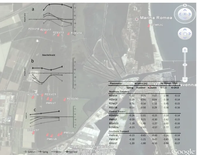
To characterize the aquifer of the San Vitale pine forest and Punte Alberete swamp area, a total of 15 piezometers, subdivided in three transects, were selected (Figure 1). Sampling sites are quite perpendicular to the shore, from the Adriatic Sea landward into the studied area, over a distance from 3500 to 5800 m from the shoreline.
The transect at north is situated between Punte Alberete and the northern part of San Vitale pine forest; it consists of 4 iron cased piezometers, screened in the last metres and penetrate the aquifer to a depth of 6 metres.
The transect situated in the central part of the pine forest is oriented across the Cerba channel and include 5 piezometers cased of polyvinylchloride (PVC): 4 screened from 0.5 m down to 15 m, penetrating most of the upper aquifer while the other one is screened from 13.7 m to a depth of 27 m, so as to extract groundwater only by the lower aquifer. The transect comprises the dunes of San Vitale and cropland under fruit cultivation in the western part.
Finally, the transect in the southern part of the area under examination is composed by 5 PVC piezometers, three of them are fully screened while the other 2 are catching groundwater only by the lower aquifer. The hydrology of the area is eventually under the influence of the Staggi Channel to the south and to the pumping machine to the west, which drain adjacent agricultural field.
Groundwater sampling along the three transects was performed during three field-‐ campaign: from May to December 2009. 45 groundwater samples from 15 piezometers were extracted in between May and July 2009. Further, 15 groundwater samples were collected in September from the central transect in order to examine the variation of its composition after the season of uppermost water demand. Finally, additional 20 groundwater samples were collected in December to determine the influence of the rainy period on the aquifer. A seawater sample was taken as a reference value from the Adriatic Sea at Lido di Marina to allow a comparison with the groundwater sample constitution. The Table 1 shows location and description of sampling points.
All the piezometers were sampled with a depth specific method by using the Packer system except for the piezometers PMSV6 and PMSV8 during spring, sampled with a depth integrated method, by flushing it completely; thus, deriving information about the entire water column.
Table 1: Sampling point location and description.
X Y
Distance+
from+sea+(m) Altitude+(m) Depth+(m)+ Material Transect Screen+(m)
PZSV17 757245 934153 4700 1.88 6 iron Northern full
PZSV18 755773 934520 5000 1.20 6 iron Northern full
PZSV13 756802 934118 4000 1.89 6 iron Northern full
PZSV14 757243 934140 3500 1.50 6 iron Northern full
PZSVS23 756350 930622 5100 0.65 15 PVC Central full PZSVS30 757486 930511 4000 0.85 15 PVC Central full PZSVS26 755886 930335 5600 0.66 15 PVC Central full PMSV7 756882 930638 4600 0.44 15 PVC Central full PMSV7+p 756882 930638 4600 0.38 27 PVC Central 13.5;27 PZSV37 755920 928895 5800 0.42 15 PVC Southern full PMSV+6 756605 928665 5200 0.62 15 PVC Southern full PMSV+6+p 756589 928677 5200 0.66 27 PVC Southern 13.5;30 PMSV+8+ 757484 929151 4200 1.00 15 PVC Southern full PMSV+8+p 757484 929151 4200 1.05 27 PVC Southern 13.5;31 Sea+Water 760830 934159 0 0.00 ; ; ; ;
Before groundwater collection a depth profile of the temperature, electrical conductivity (EC), and salinity from the water table to the piezometer’s bottom was measured on-‐site (CTD-‐probe AquaTROLL®200). The water level from top of the piezometer down to the water table was measured applying an electrical water table indicator in order to allow a reference of the hydraulic head to sea level.
Samples were taken close to the water table and at the bottom of the piezometer. On the base of the EC results, one or two more sample depths were chosen where abrupt changes in EC occur as it may indicates the interface of fresh and saltwater.
Operating a straddle field packer system, with a resolution of 20 cm, the piezometers were flushed at the specific sampling window until achieving constant values of EC and salinity or three times the total volume. Flushing at moderate pumping rates by using a Solinst®410 Peristaltic Pump aims at displacing stagnant water from the piezometer and receiving a groundwater sample representative for in-‐situ conditions. The multi-‐ level sampling technique allows a depth specific approach; it consists of isolating specific sections of the monitored well with inflatable packers (bladders) considering the groundwater’s chemistry at the well-‐defined sampling window. A series of such samples allows the definition of the vertical distribution of water quality. Samples of the deeper aquifer collected during the first campaign, are subjected to a depth integrated method, i.e., the piezometer is fully flushed before extraction, thus mixing up bottom and top groundwater.
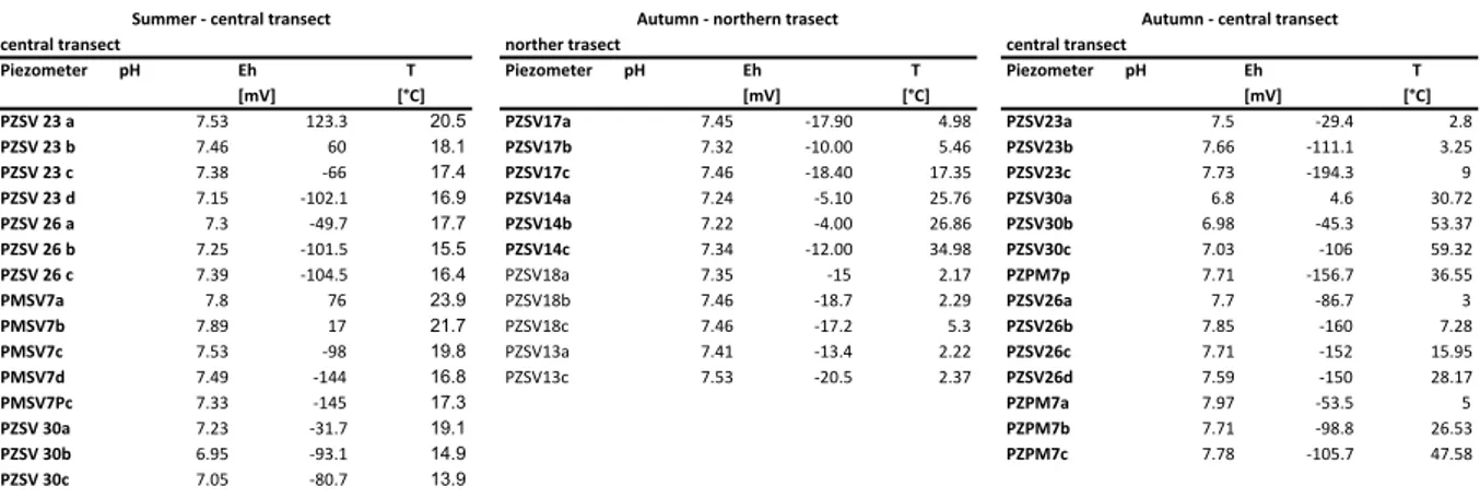
Non-‐filtered samples provided readings of pH, redox potential (Eh) and temperature utilizing a HANNA® HI 9026 pH meter. The accuracy lies in the range of ± 0.01 pH, ± 0.20 mV, ± 0.40°C. In order to prevent extended aerial exposure and the consequent risk of precipitation and flocculation, the measurements of sulphide, ferrous iron and total iron concentrations were conducted on-‐site by applying a HACH® DR/2010 Spectrophotometer. The Methylene Blue Method was applied for sulphide analysis, the FerroVer Method for total iron and 1,10 Phenanthroline Method for bivalent iron (detection limit 0.01 mg/l).
Subsamples of groundwater were filtered through a 0.45 µm cellulose filter and filled into 250 ml polyethylene (PE) bottles acidified with nitric acid (HNO3-‐) down to a pH < 2
for cation and trace element analysis, in order to prevent cation precipitation or biological uptake. Non-‐acidified samples for major anion analysis were left. Those bottles were filled completely and capped tightly before transporting them into the laboratory of the University of Bologna, where they were stored dark and refrigerated. Total alkalinity was determined in the laboratory, on a filtered subsample, by the titration method with 0.02 HCl at pH of 4.5. Major nutrient (nitrate, nitrite, ammonia, phosphate) determination was performed on filtered non-‐acidified groundwater samples employing a HACH® DR/2010 Spectrophotometer. These analyses were implemented within 24 h after sampling to avoid biogeochemical alterations. Nitrate follows the Cadmium Reduction Method and is subjected to a precision of ± 0.01 mg/l N – NO3-‐. The Diazotization Method delivers readings of nitrite at accuracies of ± 0.0011
mg/l NO2 – N, meanwhile PO43-‐ -‐ P, measured by Asorbic Acid Method, ± 1 mg/l. The
Salicylate Method applied for the detection of NH3-‐N counts with a precision of ± 0.015
mg/l.
For cation determination (Ca2+, K+, Mg2+, Na+) AAnalyst 100 Atomic Absorption
Spectrometer was operated on acidified and filtered samples, detection limits are listed as 0.01 mg/l. Previously filtered samples for major anion (SO42-‐, NO3-‐, F-‐, Br-‐, Cl-‐) were
analysed with ion-‐chromatography (IC) analysis (DIONEX®DS5 Detection Stabilizer, detection limits: 0.01 mg/l). Trace element analyses (As, Ni, Cu, Mn, Fe, Si, B) were performed on acidified groundwater samples with the inductively coupled plasma (ICP) method using an ICP 6000 Series ICP atomic emission Spectrometer (detection limits are 0.01 mg/l).