Cycling lanes and Stormwater Management: an
inte-grated project. Montesilvano as a case study
Antonio Alberto Clemente
Department of Architecture, University of Chieti-Pescara, G. d’Annunzio, IT
Highlights
• The frequency of flooding in the town of Montesilvano has risen steadily in recent years. • The La Trobe Street green bicycle lane is also an environmental infrastructure.
• The Copenhagenize Current has a twofold objective: creating a stormwater drainage network and improving cycling infrastructure.
• In Montesilvano there is a need to identify areas ready to welcome an integrated project that unites mobility with water management.
The frequency of flooding in Montesilvano has risen steadily in recent years. Linked to this phenomenon, the research agreement between the Depart-ment of Architecture in Pescara and the Town of Montesilvano includes the general objective of verifying whether the network of cycling lanes can help resolve this issue. Legislation, guidelines and best practices in his sector pro-vide no useful indications. They are linked to a qualitative hypothesis whose priority in almost all cases focuses on creating the highest possible number of kilometres of safe, functional and intermodal cycling lanes.
To identify operative references to the links between cycling lanes and storm-water management we must look at plans designed to contrast climate change. Many have a specific section dedicated to this theme: examples include Bos-ton, Copenhagen, Melbourne, Ottawa and Philadelphia. Their comparison reveals that improving stormwater management requires multiple actions. Principal actions include: breaking free of sector-specific logics, integrated projects for the spaces of the network and associated areas and the recog-nition of the importance of the relationship with context. In Montesilvano, marked by two parallel north-south axes (the Parkway and the Waterfront) and its five perpendicular east-west lines (Grandi alberghi, via Strasburgo, via Marinelli, via Torrente Piomba, Palaroma), there is a need to identify ar-eas ready to welcome a project that successfully combines bicycle mobility with stormwater treatment and management. This is the responsibility the research intends to assume in the near future.
Received: May 31, 2018 Reviewed: July 31, 2018 Accepted: August 03, 2018 On line: September 30, 2018
Article history
Abstract
Keywords
Urban flooding Soil sealing Copenhagenize current Trobe Street Integrated project1.
Introduction
The frequency of flooding in the town of Monte-silvano has risen steadily in recent years. This problem is caused less by rainfall over the course of multiple days, and more by concentrated events lasting a few days or even a few hours. In other words, extreme climatic events cause the greatest problems. This situation is largely a result of ex-cessive soil sealing and the overloading of the sew-er network. This should come as no surprise, as Montesilvano is part of a more general story: the construction of the Adriatic city after the Second World War. The principal characteristic of this ex-traordinary growth was demographic. According to ISTAT, the population rose from little more than 7,000 people (1951) to almost 30,000 (1981), reaching more than 50,000 (2011). The registra-tion of 54,000 residents in this town is proof that this growth continues. Population growth was ac-companied by the phenomenon of second homes and hotel structures, built to satisfy the demand for seaside bathing. In addition, to better under-stand the phenomenon of soil sealing, it must be noted that the municipal area of Montesilvano measures little more than 23.57 km2 (2,300 res/ km2), situated between the coast line, important territorial infrastructures (the Adriatic railway, State Road 16, the A14 motorway) and the Saline River.
In this context, urban flooding caused by extreme climatic events has become a priority. There is a need to offer a response to the potential risks to which the population is exposed and the potential damages to cultural heritage, infrastructures and homes. In light of these considerations, the agree-ment between the Departagree-ment of Architecture of Pescara and the Town of Montesilvano, created to explore the relationship between slow mobili-ty and cycling lanes, has been enriched by a new line of research focused on verifying the possibili-ty of establishing a link between cycling lanes and stormwater collection and management.
2.
Regulations, guidelines, best
practices
The study began by looking at urban planning reg-ulations. In 1995, the principal concern expressed in the Direttive per la redazione, adozione ed at-tuazione dei Piani Urbani del Traffico (Directives
for the Preparation, Adoption and Implementation of Urban Traffic Plans) in relation to pedestrians and cyclists, was to “provide all interventions use-ful and necessary for guaranteeing safety”. Suc-cessively, in 1998, the Norme per il finanziamento della mobilità ciclistica (Regulations for Financing Bicycle Mobility) anticipated, on the one hand, an intermodal relationship between bicycles and public transport and, on the other hand, identified priority areas for the realisation of cycling lanes along abandoned or unused rail lines and river-banks. The following year, the Ministry of Public Works, together with the Ministry of Transport, issued the Regolamento recante norme per la definizione delle caratteristiche tecniche delle piste ciclabili (Regulation Containing Rules for Defining the Technical Characteristics of Cycling Lanes). The aims of this regulation included “fa-vouring and promoting an elevated level of bicycle and pedestrian movement, as an alternative to the use of combustion engine vehicles in urban areas […]; focusing on the attractiveness, continuity and recognisability of cycling routes […]; evaluating the profitability of investments in relation to real and potential users and in relation to the objective of reducing the risk of accidents and levels of at-mospheric and acoustic pollution; verifying the concrete feasibility and real utilisation of cycling lanes by users”. In 2013, the strategic objectives for urban bicycle mobility in the region of Abruz-zo were: increasing the existing network of cycling lanes (privileging the creation of a network), im-proving safety, including the introduction of spe-cific signage and the connection with the system of public mobility. The regulations for the prepara-tion of the Biciplans (Bike Plans) contained in Law 2/2018 can be ascribed to a vast register: “towns not part of metropolitan cities and metropolitan cities are to prepare and adopt, in relation to their budget [...] and its eventual modifications, plans for urban bicycle mobility, known as “biciplans”. These Piani Urbani della Mobilità Sostenibile (PUMS), or plans for sustainable urban mobility, are to focus on defining objectives, strategies and actions necessary to promote and intensify the use of the bicycle as a means of transport for daily movements and activities related to tourism and recreation and to improve safety for cyclists and pedestrians”.
Another analytical approach is tied to the com-parison between the extraordinary production of Guidelines. There are substantially five main ar-eas of investigation: the identification of the
net-the most effective signage; identifying net-the geomet-ric standards for the various typologies of paths, also considering that “without cohesion there is no network, only a bunch of single routes. This is a matter of degree: the more routes interconnect and allow cyclists to freely choose their itinerary, the stronger the network is. For cyclists, cohesion is a very real quality: it is the extent to which they can reach their destination via the route of their choice.” (European Community, 2010).
As far as best practices are concerned, we referred to the Guida ai comuni ciclabili d’Italia, the Guide to Bikeable Towns in Italy, published by the Feder-azione Italiana Amici della Bicicletta (FIAB). The Guide is supported, among others, by the Sapien-za University of Rome, the Associazione Nazionale Comuni Italiani (ANCI) and the European Cyclist Federation (ECF). Evaluations in the Guide are based on four indicators. Bicycle tourism as an open and welcoming territory of paths, protect-ed itineraries (urban and suburban) an dprotect-edicatprotect-ed services, including: bicycle repair shops, rental facilities, guides for cyclists and “bicycle friend-ly” hospitality structures. The second indicator is
activation of policies for urban mobility, such as, for example, the nomination of mobility managers and regular home-school mobility services such as a bikebus. The final element involves strategic Communication linked to issues of sustainable mobility, which must be integrated with events and promotional activities intent on stimulating the use of the bicycle.
These brief considerations hint at how regula-tions and guidelines are linked to a framework of quantity. The priority appears to be the creation of the greatest number of kilometres of cycling lanes that are safe, functional and intermodal. Despite the Guide’s declared objective to “stimulate and accompany a virtuous process of restoring the city and public space to people ... to break free of the distorted logic of competing to see who has the most km of cycling lanes” (Guida ai comuni cicla-bili d’Italia, 2018), the effort appears insufficient for escaping from the sector-specific logic that re-mains wholly within the realm of the bicycle. That said, the intention here is not to discuss the impor-tance of regulations, guidelines or to explore best practices. Instead, the aim is to demonstrate that
Time Frame Water Management Cycling Lanes Integrated Management
of Stormwater and Cy-cling Lanes
Imagine Boston 2030
2017 - 2030 Climate Ready BostonGreenovate Boston Boston Bike Network Plan Plan Melbourne
2017 - 2050 Municipal Integrated Wa-ter Management Plan Bicycle Plan 2016-2020 The La Trobe Street bicy-cle lane Ottawa 20/20
2000 - 2020 River Action Plan Ottawa Cycling Plan Philadelphia Citywide
Vision 2011 - 2035
Green City, Clean Water The Philadelphia Pedestri-an
& Bicycle Plan
City of Philadelphia Green Streets Design Manual Copenhagen Climate
Ad-aptation Plan 2011 - 2025
The Cloudburst
Manage-ment Plan The City of Copenhagen’s Bicycle Strategy 2011-2025 The Copenhagenize Cur-rent -Stormwater Man-agement and Cycle Tracks Table 1: Water Management Plans and cycling lanes
they are not sufficient to construct a network of cycling lanes able, even only in part, to take on the problems/opportunities offered by the territories it crosses. One example: is it possible that the con-struction of cycling lanes can contrast urban flood-ing caused by extreme climatic events?
3.
Broadening the horizon
This question obliges us to look elsewhere. For example, to the cities that have approved plans to contrast climate change and for bicycle mobility, listed in the table 1.
In Boston and Ottawa, stormwater management plans do not appear to have structural ties with cycling lanes, but instead with projects linked to urban areas and road infrastructures. A different situation is found in Philadelphia, where the Green City-Clean Water plan, whose general aim is to avoid overloading the sewer network, is based on a number of cardinal criteria such as recharging water tables and maintaining and expanding wa-ter infrastructures. It is precisely in this direction that a network of cycling lanes, as part of an in-frastructural system, enters the realm of planning. In particular, in the City of Philadelphia Green Streets Design Manual, which identifies six green stormwater infrastructures for the collection and management of stormwater in densely urbanised areas:
•
permeable pavement whose porous surface and subterranean stone reservoir provide temporary storage, before the water filters into the ground. Naturally, there are many types of porous surfaces, including permeable asphalt and permeable pavers. These latter function differently than permeable asphalt and concrete. Instead of allowing water to penetrate through the paved surfaces, the pav-ers typically allow water to pass through the joint spacing between the pavers.•
stormwater planters or rain gardens. Similar to flower beds, they tend to be longer than they are wider. Flanking sidewalks they are used to manage runoff from the street and sidewalk. The level of the planting media in the planter is lower than the sidewalk and paralleled by a drain at the street edge. Rain gardens are used to manage rainwater by allowing for its storage, infiltration and evapotranspiration.Excess runoff is channelled into an overflow pipe connected to the existing sewer network;
•
stormwater bump-outs (midblock and cor-ner). These planted extensions of the side-walk project out into the street, midblock or at intersections to create what is to all intents and purposes a new curb located close to the existing one. A bump-out consists of a layer of stone covered with soil and plants. The slope of the sidewalk deviates the flow of rainwater so that it can be stored, filtered and collected by plants (evapotranspiration). Excess runoff can be channelled into the existing sewer net-work;•
stormwater trees. This term refers to a tree planted in a bed set into the sidewalk. The up-per surface of the planting media is set below street level, and runoff is managed by drains. Water from the sidewalk runs directly into the bed. It is possible to imagine a series of tree beds that are able to manage the highest vol-ume of rainwater, which can successively be filtered or channelled into the sewer system;•
stormwater tree trenches. This is a system oftrees connected to an underground infiltration system. On the surface, it resembles a normal sequence of planted trees. However, in reality it is a system composed of trenches dug be-neath the sidewalk, finished with a permeable geotextile fabric and filled with stones or grav-el, covered by the amount of terrain required to support the trees’ root balls. Rainwater flows from the sloping sidewalk and from the street into a horizontal drain connected to the underground infiltration system. Water can be stored in void spaces between stones and used to irrigate the trees and slowly filter through the base layer;
•
green gutter. This narrow, elongated and shal-low landscaped strip along the street curb (or that of a bicycle lane) that manages storm-water runoff. The upper layer of the planting media is set lower than the street level to aid runoff from the street and sidewalk. The sys-tem attenuates stormwater flows, provides for storage and, in some cases, filtration and evap-otranspiration. In flow-through green gutters, overflow runoff can be conveyed to the existing storm drain system, either through an underd-rain tied to the existing storm dunderd-rain system, or as shallow concentrated flow that is conveyed downstream to an existing inlet.4.
The La Trobe Street green
bi-cycle lane
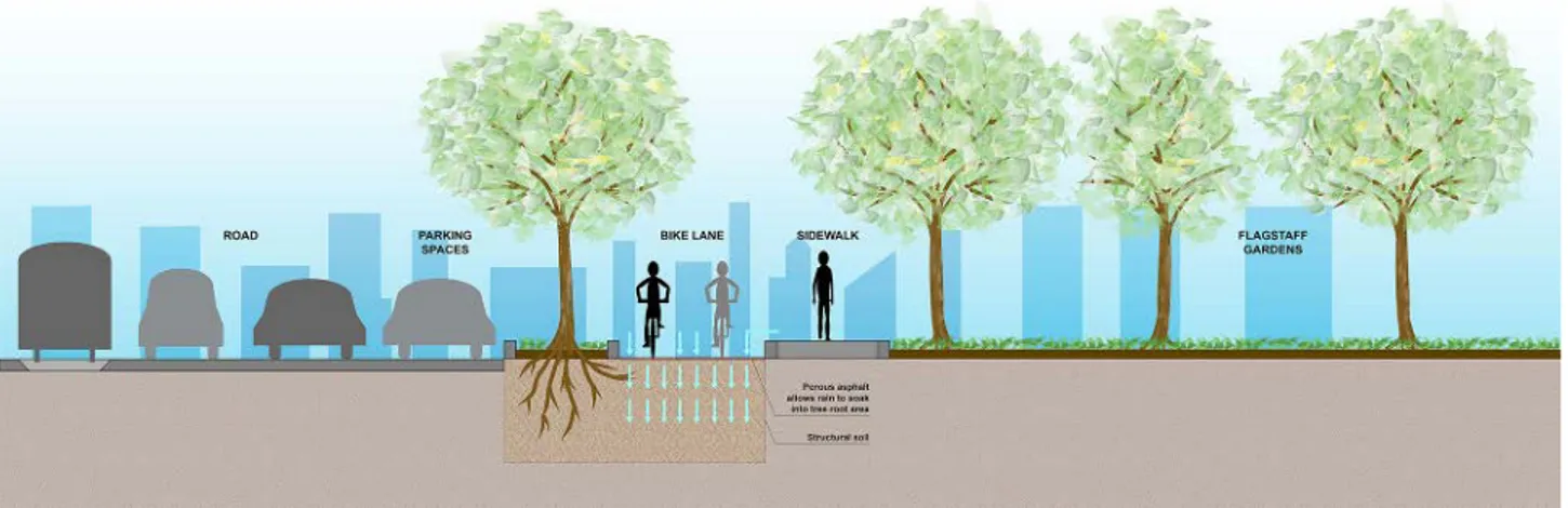
The La Trobe Street green bicycle lane is a new cycling lane with its own dedicated space. The de-sign involves the narrowing of the roadbed and the modification of parking stalls. The lane is sep-arated from the street by a traffic divider that also serves as a planting bed for trees. This bed is used to channel stormwater from the street and water that penetrates through the porous asphalt fin-ish of the bike lane. The structure of the planting bed is designed to favour the passive irrigation of the tree roots. On the one hand this limits the risk of flooding and, on the other hand, helps reduce stormwater pollution.
Thermal imagery has shown La Trobe Street to be one of the hottest areas in the city. The planting of trees that cover the bicycle lane serves not only to collect and manage stormwater, but also to cre-ate shade and cool the air. However, the trees can also have a negative impact on safety for cyclists. A study identified three actions for reducing this risk: the use of bike-friendly drain covers, prun-ing of the trees up to a height of 2.4 metres above street level to maintain the efficiency of sunlight and the selection of trees with slender trunks. The La Trobe Street green bicycle lane belongs to a vaster understanding of the contribution to the implementation of the Total Watermark: City as a Catchment Strategy for the integrated water cycle management; the Urban Forest Strategy program to create a more resilient, healthier and diversi-fied city by increasing urban plantings; the Bicycle Plan whose primary aim is to increase the safety and attractiveness of cycling lanes and the Climate
Change Adaptation Strategy, which includes a line of specific actions designed to contrast urban flooding caused by extreme climatic events. In light of these brief considerations, The La Trobe Street green bicycle lane is more than a bicycle lane. It is also an environmental infrastructure that integrates soil permeability with stormwater catchment, passive irrigation and the objective of contrasting heat islands.
5.
The Copenhagenize Current
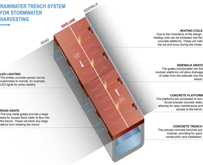
Torrential rains have often flooded entire neigh-bourhoods in Copenhagen. The cause lies in the inability of the sewer network to handle the vol-umes of water created by these extreme atmos-pheric events. Solutions tested as part of the Cli-mate Adaptation Plan include cloudburst streets: large green spaces that function as stormwater catchment areas. The precise objective of ensuring that even narrow streets can resist against urban flooding led to the creation of The Copenhagen-ize Current - Stormwater Management and Cycle Tracks. The strong idea is to provide the space be-neath the city’s vast network of bicycle lanes with a secondary system of stormwater channels and to improve the city’s cycling infrastructure. The system consists of prefabricated concrete chan-nels covered by prefabricated concrete slabs that create the surface of the bicycle lanes. The offer the necessary support for the weight of the city’s thousands of cyclists, as well as automotive traffic at lane crossings. In addition, the slabs are fitted with LED lights that improve visibility and heat-ing coils that melt ice durheat-ing the winter. The sys-Figure 1: Melbourne, section de La Trobe Street green bicycle lane. Source: original drawing by arch.
tem also includes drainage channels at the edge of lanes and street curbs that drain runoff from both sides and capture any detritus. The entire system is easy to install and maintain and, among other things, also provides the possibility to reserve space for the eventual passage of underground urban services. The Copenhagenize Current inte-grates the existing sewer network to accelerate stormwater drainage by channelling water toward the river, the sea and Sankt Jørgens Lake. Copenha-gen currently boasts 369 km of bicycle lanes, two bike-only bridges and a very high level of safety across the entire network. Furthermore, actions by city government that give priority to bicycles and dissuade the use private automobiles, mean that bicycles travel faster than cars. However, this is still not considered enough. The Copenhagen-ize Current - Stormwater Management and Cycle
Tracks demonstrates the necessity to concentrate the functions of this network, in addition to sim-ply supporting bicycle mobility. It also shows how this effort is indispensable to any project intent on integrating bicycle mobility and stormwater man-agement.
6.
A few considerations
These considerations raise a few questions: under what conditions can a network of bicycle lanes be-come part of an integrated project that helps im-prove stormwater treatment and management? The suggestions provided by Philadelphia, Mel-bourne and Copenhagen are clear: the network of cycling lanes is a project for the surface of the Figure 2: The prefabricated concrete canals assumed in Copenaghen, with their concrete covering
city whose realisation requires the integration be-tween multiple lines of action. There are three pri-mary lines of action. The first concerns the need for a new point of view. In addition, we must also break free of sector-specific logics. The time has come to move beyond the idea that cyclists require a small highway offering mono-functional connec-tions between different points in the city, the ex-clusive use of this space and a guarantee of safety. This network is not only an infrastructure for slow mobility, but also an urban system that, in this specific case, represents the space and grouping of systems used to treat and manage stormwater, as an alternative to the existing sewer network. This approach could be adopted in Montesilvano, giv-en its currgiv-ent situation as a virtuous settlemgiv-ent with an important number of kilometres of exist-ing bike lanes: the town has completed the entire section of the Ciclovia Adriatica, the Adriatic Bike Network, under its responsibility and is listed in the Guida ai comuni ciclabili d’Italia. However, this is not enough: dealing with a theme as vast as that of contrasting the negative effects of extreme
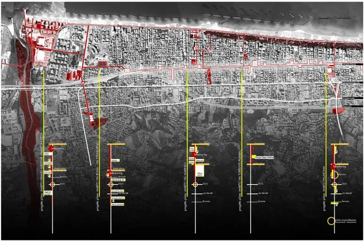
cli-matic events cannot be limited to lip service, but must imagine a series of architectural devices able to serve, initially, as design hypotheses and, suc-cessively, as concrete responses. This is precisely the direction of the second line of action, in other words, the choice made, even if implicitly, in the City of Philadelphia Green Streets Design Manu-al, the La Trobe Street green bicycle lane and The Copenhagenize Current – Stormwater Manage-ment and Cycle Tracks: integrated intervention in the space of the network and the associated areas adjacent to this infrastructure or in its immediate surroundings. This is why Montesilvano must once again reflect on the role of its two parallel north-south axes (Parkway and Waterfront) and its five perpendicular east-west axes (Grandi alberghi, via Strasburgo, via Marinelli, via Torrente Piomba, Palaroma), to understand where to use draining surfaces, stormwater outflow channels or storm-water infrastructures. This choice must necessari-ly take into account geomorphological conditions, road sections, the possibility – or not – to integrate the system of underground services and, more in Figure 3: Montesilvano: identification of potential axes of stormwater treatment and management.
general, the technical and economic feasibility of similar operations. This is where the third line of action becomes fundamental: emphasising the im-portance of the relationship with context. Working with the hypothesis that a network of bicycle lanes is a relational project obliges us to pay more atten-tion to urban identities; to the particular nature of
parts of the city; to assume the centrality of the no-tion of public space. In Montesilvano this is the way to clearly identify those areas that conceal the signs of expectation of a project that successfully unites the network of bicycle lanes with stormwater treat-ment and managetreat-ment. This is the responsibility the research intends to assume in the near future.
to. Un problema che deriva, non tanto dalla piog-gia distribuita su più giorni, quanto piuttosto da quella concentrata in pochi giorni o addirittura in poche ore. In altre parole, sono gli eventi at-mosferici estremi quelli che causano i maggiori problemi. Uno stato di fatto che deriva in buona parte dell’eccessiva impermeabilizzazione del suolo e dalle condizioni di sovraccarico della rete fognaria. Né poteva essere altrimenti, conside-rando che Montesilvano è parte di una storia più generale: la costruzione della città adriatica avve-nuta dal secondo dopoguerra in poi. La principa-le caratteristica di questa straordinaria crescita è stata l’incremento demografico. Secondo i dati ISTAT la popolazione è aumentata da poco più di 7.000 persone (1951) a quasi 30.000 (1981), per superare le 50.000 (2011). E continua ancora a crescere tenuto conto che, all’anagrafe comuna-le, risultano 54.000 residenti. Ai dati demografici vanno aggiunti sia il fenomeno delle seconde case sia quello delle attività ricettive, nate per soddisfa-re la domanda del turismo balneasoddisfa-re. Inoltsoddisfa-re, per comprendere meglio il fenomeno dell’imperme-abilizzazione del suolo, va sottolineato come la superficie comunale di Montesilvano è di appena 23,57 km2 (2.300 ab/km2) ed è compressa tra la linea di costa, le grandi infrastrutture territoriali (Ferrovia adriatica, Strada Statale 16, Autostrada A 14), urbane (Asse attrezzato) e il fiume Saline. In tale contesto, gli allagamenti urbani derivanti da eventi atmosferici estremi sono diventati una priorità alla quale dare una risposta sia in relazio-ne ai potenziali rischi cui è sottoposta la popola-zione sia per i danni che potrebbero subire il patri-monio culturale, infrastrutturale e abitativo. Alla luce di queste considerazioni, la Convenzione tra il Dipartimento di Architettura di Pescara e il Comu-ne di Montesilvano, nata per indagare il tema del rapporto tra Slow mobility e reti ciclopedonali, si è arricchita di una nuova linea di ricerca tesa a veri-ficare se tra reti ciclabili, raccolta e gestione delle acque meteoriche esista la possibilità di stabilire una connessione.
settore in ambito urbano. Nel 1995, con le Diret-tive per la redazione, adozione ed attuazione dei Piani Urbani del Traffico, la principale preoccupa-zione, con riferimento a pedoni e ciclisti, è quella di “prevedere tutti gli interventi utili e necessari a garantirne la sicurezza”. In seguito, nel 1998, le Norme per il finanziamento della mobilità cicli-stica auspicano, per un verso, l’intermodalità tra biciclette e mezzi di trasporto pubblico e, per altro verso, identificano gli ambiti prioritari per la rea-lizzazione delle piste ciclabili, nell’area di sedime delle ferrovie dismesse o in disuso e negli argini dei fiumi. L’anno successivo, il Ministro dei Lavori Pubblici di concerto con il Ministro dei Trasporti emanano un Regolamento recante norme per la definizione delle caratteristiche tecniche delle pi-ste ciclabili le cui finalità consistono “nel favorire e promuovere un elevato grado di mobilità ciclistica e pedonale, alternativa all’uso dei veicoli a moto-re nelle amoto-ree urbane […]; puntamoto-re all’attrattività, alla continuità ed alla riconoscibilità dell’itine-rario ciclabile […]; valutare la redditività dell’in-vestimento con riferimento all’utenza reale e po-tenziale ed in relazione all’obiettivo di ridurre il rischio d’incidentalità ed i livelli di inquinamento atmosferico ed acustico; verificare l’oggettiva fat-tibilità ed il reale utilizzo degli itinerari ciclabili da parte dell’utenza”. Nel 2013 gli obiettivi strategici per la ciclomobilità urbana della Regione Abruz-zo sono: l’incremento della rete ciclabile esistente (privilegiandone la messa in rete), la sua messa in sicurezza, anche attraverso specifica segnala-zione e la connessione con il sistema della mobi-lità collettiva. Né possono ascriversi a un registro molto diverso, le norme per la redazione dei Bici-plan previsti dalla Legge 2/2018: “i comuni non facenti parte di città metropolitane e le città me-tropolitane predispongono e adottano, nel rispet-to del quadro finanziario […] e dei suoi eventuali aggiornamenti, i piani urbani della mobilità cicli-stica, denominati “biciplan”, quali piani di settore dei piani urbani della mobilità sostenibile (PUMS), finalizzati a definire gli obiettivi, le strategie e le
Piano
Orizzonte temporale Gestione delle acque Rete ciclabile Gestione integrata ac-que meteoriche e reti ciclabilis
Imagine Boston 2030
2017 - 2030 Climate Ready BostonGreenovate Boston Boston Bike Network Plan Plan Melbourne
2017 - 2050 Municipal Integrated Wa-ter Management Plan Bicycle Plan 2016-2020 The La Trobe Street bicy-cle lane Ottawa 20/20
2000 - 2020 River Action Plan Ottawa Cycling Plan Philadelphia Citywide
Vision 2011 - 2035
Green City, Clean Water The Philadelphia Pedestri-an
& Bicycle Plan
City of Philadelphia Green Streets Design Manual Copenhagen Climate
Ad-aptation Plan 2011 - 2025
The Cloudburst
Manage-ment Plan The City of Copenhagen’s Bicycle Strategy 2011-2025 The Copenhagenize Cur-rent -Stormwater Man-agement and Cycle Tracks Tabella 1: Piani per la gestione delle acque e reti ciclabili
azioni necessari a promuovere e intensificare l’uso della bicicletta come mezzo di trasporto sia per le esigenze quotidiane sia per le attività turistiche e ricreative e a migliorare la sicurezza dei ciclisti e dei pedoni”.
Un altro itinerario analitico è inerente alla com-parazione della straordinaria produzione di Linee guida. I principali ambiti di approfondimento sono sostanzialmente cinque: identificazione della rete, segnaletica, sicurezza, materiali e caratteristiche dimensionali del tracciato. Le finalità delle linee guida consistono nel diffondere l’uso della bici-cletta come mezzo di trasporto per gli spostamenti casa-lavoro/scuola; nel chiarire i benefici ambien-tali, sociali ed economici legati all’utilizzo della biciletta rispetto alle tradizionali forme di mo-bilità motorizzata; nel garantire un elevato stan-dard di sicurezza riducendo al minimo il rischio di incidenti o qualsiasi altra forma di pericolo per il ciclista; nel definire quale sia la segnaletica più efficace; nell’individuare gli standard geometrici delle varie tipologie di tracciato, anche in conside-razione del fatto che “senza continuità non c’è rete, ma solo singoli percorsi. È questione di grado: più i percorsi sono interconnessi tra loro e permettono ai ciclisti di scegliere liberamente il proprio itine-rario, più forte è la rete. Per i ciclisti la continuità è una qualità molto concreta: è l’estensione spa-ziale entro la quale possono raggiungere una meta seguendo un percorso da loro scelto” (“Comunità Europea”, 2010).
Per quanto attiene alle Buone pratiche, il riferi-mento è la Guida ai comuni ciclabili d’Italia edita dalla Federazione Italiana Amici della Bicicletta
(FIAB), e che ha ottenuto il patrocinio, tra gli altri, dell’Università di Roma La Sapienza, dell’Associa-zione Nazionale Comuni Italiani (ANCI) e dell’Eu-ropean Cyclist Federation (ECF). Le valutazioni della Guida sono basate su quattro indicatori. Il Cicloturismo inteso come territorio aperto e ac-cogliente dotato di ciclovie, di percorsi ciclabili protetti (urbani ed extraurbani), e servizi dedica-ti quali: ciclofficine, noleggio e guide per ciclisdedica-ti e strutture ricettive “bicycle friendly”. Il secondo in-dicatore è quello della mobilità urbana che tende a verificare quanto fanno i comuni per ridurre l’uso dell’auto privata in favore della bicicletta. In parti-colare attraverso la realizzazione di ciclabili urba-ne separate dalla viabilità ordinaria e l’istituziourba-ne delle Zone 30 con la finalità di limitare il traffico e la velocità. Terzo è la Governance intesa come ca-pacità di affiancare alla realizzazione delle infra-strutture una molteplicità di azioni quali la ridu-zione del tasso di motorizzaridu-zione e l’attivaridu-zione di politiche per la mobilità urbana quali, ad esempio, l’istituzione di mobility manager e i servizi regola-ri di mobilità casa-scuola come bicibus. In ultimo, vi è la Comunicazione strategica sui temi della mo-bilità sostenibile che deve procedere in maniera integrata con le iniziative di animazione e promo-zione tese a incentivare l’uso della bicicletta. Queste brevi considerazioni, lasciano trasparire come Normativa e Linee guida si collochino all’in-terno di un’ipotesi quantitativa, la cui priorità è realizzare il maggior numero possibile di chilome-tri di piste ciclabili in cui sia garantita la sicurez-za, la funzionalità del tracciato e l’intermodalità. E nonostante l’obiettivo dichiarato della Guida sia
per costruire una rete ciclabile che sappia farsi carico, sia pur in parte, dei problemi/opportunità dei territori e dei paesaggi che attraversa. Come, ad esempio, porsi la domanda: esiste la possibilità che la costruzione della rete ciclabile possa con-trastare gli allagamenti urbani derivanti dai feno-meni meteorici estremi?
3.
Ampliare lo sguardo
Di fronte a questa domanda occorre guardare al-trove. A quelle città che abbiano approvato sia pia-ni per contrastare i cambiamenti climatici sia per la mobilità ciclistica, come riportato in tabella. A Boston e Ottawa, il piano per la gestione delle acque meteoriche non sembra avere dei rapporti strutturali con le reti ciclabili ma con progetti spe-cifici legati ad ambiti urbani e alle infrastrutture stradali. Diverso è il caso di Philadelphia, dove il piano Green City-Clean Water, la cui finalità gene-rale è quella di evitare il sovraccarico della rete fognaria, si basa su alcuni criteri cardine quali la ricarica delle falde acquifere e la manutenzione e ampliamento delle infrastrutture idriche. Ed è pro-prio in tal senso che la rete ciclabile, come parte del sistema infrastrutturale, trova spazio nel piano e, più in particolare, nel City of Philadelphia Green Streets Design Manual all’interno del quale sono individuate le sei green stormwater infrastructu-res per la raccolta e la gestione delle acque meteo-riche in aree densamente urbanizzate:
•
pavimentazione permeabile che, con la sua su-perficie porosa e il serbatoio di pietra sotterra-neo, funge da deposito temporaneo prima che l’acqua si infiltri nel terreno. Naturalmente, esistono molti tipi di superfici porose tra cui asfalto e il calcestruzzo permeabile e le lastre a incastro. Le finiture a incastro funzionano in modo diverso rispetto all’asfalto e al calce-struzzo. Piuttosto che permettere all’acqua di penetrare attraverso la pavimentazione, lela-lo stradale. I raingardens gestiscono le acque piovane perché consentono lo stoccaggio, l’in-filtrazione e l’evapotraspirazione. Il deflusso in eccesso viene diretto in un tubo di troppo pieno collegato alla fognatura esistente;
•
stormwater bump-outs (midblock andcor-ner). È un’estensione vegetata del marciapie-de che sporge nella strada, a metà isolato o in corrispondenza dell’incrocio, realizzando, di fatto, un nuovo cordolo non distante da quel-lo esistente. Un bump-out è composto da uno strato di pietra ricoperto da terreno e piante. La pendenza del marciapiede devia il deflusso dell’acqua meteorica in modo tale che possa essere immagazzinato, filtrato e raccolto dalle piante (evapotraspirazione). Il deflusso in ec-cesso può essere convogliato nella rete idrica esistente;
•
stormwater tree. Ci si riferisce a un albero piantato in un’aiuola ricavata nel marciapiede. La parte superiore del terreno dell’aiuola, si trova a una quota inferiore rispetto alla sda sda cui riceve il deflusso delle acque per tra-mite di una caditoia. Dal marciapiede, invece, l’acqua arriva al terreno grazie alla pendenza. È possibile progettare in serie più aiuole per alberi in maniera tale da trattare una maggio-re quantità di acque piovane che, in seguito, potrà essere filtrata o convogliata verso la rete fognaria;•
stormwater tree trenches. Si tratta di un siste-ma di alberi collegato a una struttura di infil-trazione sotterranea. In superficie, si presenta come una sequenza di normali aiuole per al-beri. Tuttavia, è un sistema composto da una trincea scavata sotto il marciapiede, rivestita con un tessuto geotessile permeabile, riempito di pietra o ghiaia ricoperto dal terreno neces-sario alle radici degli alberi. Le acque meteo-riche defluiscono dal marciapiede grazie alla pendenza e dalla strada attraverso una cadito-ia orizzontale che consente il raggiungimento della struttura di infiltrazione sotterranea. LoFigura 1: Melbourne, sezione de La Trobe Street green bicycle lane. Fonte: elaborazione originale dell’arch. Anna Laura Casiello
stoccaggio delle acque avviene negli spazi vuo-ti tra le pietre, irrigando gli alberi e lentamente infiltrandosi attraverso il fondo;
•
green gutter. È una striscia di verde stretta, lunga e poco profonda che si estende lungo il cordolo di una strada (o di una pista ciclabile), progettata per gestire il deflusso delle acque piovane. La parte superiore del terreno è col-locata a un livello più basso rispetto alla quota della strada in modo tale da agevolare il flusso delle acque che avverrà, grazie alla penden-za, anche dal marciapiede. Il sistema attenua i flussi di acqua piovana, fornisce lo stoccaggio e, in alcuni casi, la filtrazione e l’evapotraspi-razione. Nei green gutter a flusso continuo, è possibile convogliare il ruscellamento in ec-cesso del sistema di drenaggio esistente, sia attraverso una sottoscocca collegata al siste-ma di drenaggio esistente, sia come flusso con-centrato poco profondo che viene convogliato a valle.4.
La Trobe Street green bicycle
lane
La Trobe Street green bicycle lane è una nuova pi-sta ciclabile su sede propria. Il progetto ha previ-sto il restringimento della carreggiata e la modi-fica della posizione dei parcheggi. La separazione rispetto alla strada carrabile avviene per tramite di uno spartitraffico, all’interno del quale sono pian-tati una serie di alberi, la cui finalità è convogliare l’acqua piovana che proviene sia dalla superficie
stradale sia quella che penetra nell’asfalto poroso di cui è composta l’area di sedime su cui transita-no le biciclette. La struttura che contiene il terre-no in cui affondaterre-no le radici degli alberi è fatta in maniera tale da favorire l’irrigazione passiva. Ciò consente per un verso la diminuzione del rischio di allagamenti urbani e, per altro verso, la riduzio-ne dell’inquinamento delle acque meteoriche. Le immagini termiche hanno evidenziato che La Trobe Street è una delle zone più calde della città. Pertanto, l’inserimento degli alberi che formano una copertura a volta lungo il percorso della pista ciclabile, non ha solo lo scopo della raccolta e della gestione delle acque meteoriche ma anche di cre-are ombra e agevolcre-are il raffrescamento dell’aria. Gli alberi, però, potrebbero avere un impatto nega-tivo sulla sicurezza dei ciclisti. Per questo monega-tivo è stato commissionato uno studio che ha stabilito tre azioni per ridurre al minimo questo rischio: l’uso di caditoie ciclabili, la potatura ad almeno 2,4 m sopra la base stradale per mantenere l’efficacia della luce solare e la scelta di alberi con un diame-tro stretto del diame-tronco.
La Trobe Street green bicycle lane rientra in un più ampio quadro di coerenza considerando che è un contributo all’attuazione della Total Watermark - City as a Catchment ovvero il piano per la gestione integrata del ciclo idrico; dell’Urban Forest Stra-tegy che è il programma per rendere la città più resiliente, sana e diversificata grazie all’incremen-to del verde urbano; del Bicycle Plan il cui scopo principale è rendere le infrastruttura ciclabili più sicure e attraenti e del Climate Change Adaptation Strategy che prevede una linea di azioni specifiche tese a contrastare gli allagamenti urbani derivanti da fenomeni meteorici estremi.
affer-Figura 2: I canali prefabbricati in calcestruzzo ipotizzati a Copenaghen, con la loro copertura in calcestruzzo che crea la superficie delle piste ciclabili. Fonte: elaborazione originale dell’arch. Anna Laura Casiello
mare che La Trobe Street green bicycle lane non è solo una pista ciclabile ma anche un’infrastruttura ambientale che ha saputo integrare la permeabili-tà del suolo con lo stoccaggio delle acque piovane, l’irrigazione passiva e il contrasto all’isola di calore.
5.
The Copenhagenize Current
Le piogge a carattere torrenziale, spesso, hanno al-lagato interi quartieri di Copenaghen. La causa sta nell’inadeguatezza della rete fognaria a trattare il volume d’acqua proveniente dagli eventi atmosfe-rici estremi. Tra i rimedi sperimentati, nell’ambito del Climate Adaptation Plan, vi sono le cloudburst streets ovvero ampi spazi verdi che fungono da stoccaggio dell’acqua piovana. Tuttavia, molte
strade non hanno una sezione tale da poter acco-gliere ampi corridoi verdi. Ed è proprio per con-sentire anche alle strade più strette di contrastare gli allagamenti urbani che è nata The Copenhage-nize Current - Stormwater Management and Cycle Tracks. L’idea forza è di utilizzare lo spazio al di sotto dell’ampia rete di piste ciclabili con il duplice obiettivo di realizzare un sistema di deflusso del-le acque piovane e migliorare l’infrastruttura per i ciclisti. Tali obiettivi sono perseguiti attraverso la creazione di canali prefabbricati in calcestruzzo, coperti da lastre in cemento anch’esse prefabbri-cate che fungono da sedime della pista ciclabile poiché possono sopportare il peso di migliaia di biciclette e consentire, comunque, l’attraversa-mento delle automobili nelle intersezioni con la viabilità carrabile. Inoltre, all’interno delle lastre sono previste sia le luci a led per migliorare la
Figura 3: Montesilvano: identification of potential axes of stormwater treatment and management. Source: original drawing by arch. Giulio Girasante and arch. Paolo Chiavaroli.
visibilità, sia le serpentine di riscaldamento per sciogliere il ghiaccio durante l’inverno. Accanto a questi accorgimenti vi sono anche le griglie di sco-lo, tanto dal lato del marciapiede quanto da quello della strada, per consentire il drenaggio dell’acqua da entrambi i lati bloccando, al contempo, il pas-saggio di detriti. L’intero sistema è di facile mon-taggio e manutenzione e prevede, tra l’altro, anche la possibilità di riservare uno spazio laddove si presentasse la necessità di integrare i sottoservizi urbani. The Copenaghenize Current va a integra-re la integra-rete fognaria esistente per acceleraintegra-re il dintegra-re- dre-naggio delle acque convogliandole verso il fiume, il mare e il lago Skt Jørgens. Copenaghen ha 369 km di piste ciclabili, due ponti esclusivamente de-stinati alle biciclette, un livello di sicurezza esteso all’intera rete. Inoltre, l’amministrazione pubblica, dando priorità alla bicicletta e disincentivando l’u-so dell’auto privata, ha permesl’u-so di raggiungere velocità medie superiori a quelle delle automobi-li. Eppure tutto ciò non è considerato sufficiente. The Copenhagenize Current - Stormwater Mana-gement and Cycle Tracks è la dimostrazione di
come occorra concentrarsi sulle funzioni che può svolgere la rete, oltre a quella di supporto per la mobilità ciclistica. E di come questo sforzo sia in-dispensabile nella prospettiva di un progetto inte-grato tra mobilità ciclistica e gestione delle acque meteoriche
6.
Spunti conclusivi
Alla luce di queste considerazioni è possibile do-mandarsi: a quali condizioni la rete ciclabile può far parte di un progetto integrato che contribuisca a migliorare il trattamento e la gestione delle ac-que meteoriche? L’indicazione che viene da Phila-delphia, Melbourne e Copenaghen appare chiara: la rete ciclabile è un progetto di suolo che per es-sere realizzato ha bisogno di integrare una molte-plicità di linee d’azione. Tre le principali. La prima concerne la necessità di cambiare punto di vista. E uscire dalla logica di settore. Occorre superare l’idea che il ciclista abbia bisogno di una piccola
seguita anche Montesilvano, considerando che è un comune virtuoso in quanto a chilometri di pi-ste ciclabili esipi-stenti: ha realizzato l’intero tratto di propria competenza della Ciclovia adriatica ed è inserito all’interno della Guida ai comuni ciclabili d’Italia. Tutto questo, però, non è sufficiente: af-frontare un tema di così ampia portata come quello di contrastare gli effetti negativi degli eventi atmo-sferici estremi non significa limitarsi a evocarlo, ma immaginare una serie di dispositivi architet-tonici che siano in grado di diventare, in prima istanza, ipotesi di progetto e, successivamente, realizzazioni. Ed è proprio questa la direzione del-la seconda linea d’azione ovvero del-la scelta fatta, sia pur in maniera implicita, nel City of Philadelphia Green Streets Design Manual, in La Trobe Street green bicycle lane e in The Copenhagenize Current - Stormwater Management and Cycle Tracks:
inter-o le stinter-ormwater infrastructures. La scelta ninter-on può che essere fatta in relazione alle condizioni geo-morfologiche, alla sezione stradale, alla possibilità di integrare o meno il sistema dei sottoservizi e, più in generale, alla fattibilità tecnica ed economi-ca dell’intervento. Per fare questo è indispensabile la terza linea d’azione: dare importanza al rappor-to con il contesrappor-to. Lavorare sull’ipotesi che la rete ciclabile sia un’opera relazionale obbliga a essere più attenti alle identità urbane; alle peculiarità dei luoghi; ad assumere come centrale la nozione di spazio pubblico. A Montesilvano, è questo il modo per identificare con chiarezza quelle aree che na-scondono i segni dell’attesa di un progetto che possa coniugare la rete ciclabile con il trattamento e la gestione delle acque meteoriche. È questa la responsabilità che la ricerca intende assumersi nel prossimo futuro
Acknowledgements
The inter-institutional collaboration between the Department of Architecture of Pescara and the City of Montesilvano, in coherence with the Protocol of Understanding, is for a two-year period (2017/2018). It focuses on the relationship between Slow Mobility and Cycling Networks. Research team: Research Coordinator - prof. Paolo Fusero; Research Coordination - prof. Antonio Alberto Clemente; Scholarship students – architects Giulio Girasante, Paolo Chiavaroli; Collaborators - arch. Paride Taurino, ing. France-sco Rossi, ing. Cristina Affatato, Giuseppe Leone, Pierluigi Petaccia, Giuseppe D’Abbraccio.
References
Bernardi W. (2013). La filosofia va in bicicletta. Milano, IT: Ediciclo.
Borlini, B., & Memo, F. (2009). Ripensare l’accessibilità urbana. Roma, IT: Cittalia-Fondazione ANCI ricerche. Castrignanò, M., Colleoni, M., & Pronello, C. (Eds.) (2012). Muoversi in città. Accessibilità e mobilità nella metropoli contemporanea. Milano, IT: Franco Angeli.
D’Ambrosio, V., & Di Martino, F. (2016). The Metropolis research. Experimental models and decision-making processes for the adaptive environmental design in climate change. UPLanD-Journal of Urban Planning, Land-scape & environmental Design, 1(1), 187-217. doi: 10.6092/2531-9906/5038
De Vleeschauwer, K., Weustenraad, J., Nolf, C., Wolfs, V., De Meulder, B., Shannon, K., & Willems, P. (2014). Green– blue water in the city: quantification of impact of source control versus end-of-pipe solutions on sewer and river floods. Water Science and Technology, 70(11), 1825-1837
Donati, A., & Petracchini F. (2015). Muoversi in città. Esperienze e idee per la mobilità nuova in Italia. Milano, IT: Edizioni Ambiente.
Elliott, A. H., & Trowsdale, S. A. (2007). A review of models for low impact urban stormwater drainage. Environ-mental modelling & software, 22(3), 394-405
Ellis, J. B. (2000). Infiltration Systems: A Sustainable Source-Control Option for Urban Stormwater Quality Man-agement?. Water and Environment Journal, 14(1), 27-34
Fletcher, T. D., Shuster, W., Hunt, W. F., Ashley, R., Butler, D., Arthur, S., ... & Mikkelsen, P. S. (2015). SUDS, LID, BMPs, WSUD and more–The evolution and application of terminology surrounding urban drainage. Urban Water Journal, 12(7), 525-542. doi: 10.1080/1573062X.2014.916314
Fleury, D. (2012). Sicurezza e urbanistica. L’integrazione della sicurezza stradale nel governo urbano. Roma, IT: Gangemi.
Freeborn, J. R., Sample, D. J., & Fox, L. J. (2012). Residential stormwater: methods for decreasing runoff and in-creasing stormwater infiltration. Journal of Green Building, 7(2), 15-30. doi: 10.3992/jgb.7.2.15
Fryd, O., Backhaus, A., Birch, H., Fratini, C. F., Ingvertsen, S. T., Jeppesen, J., ... & Jensen, M. B. (2013). Water sen-sitive urban design retrofits in Copenhagen–40% to the sewer, 60% to the city. Water Science and
Technolo-gy, 67(9), 1945-1952. doi: 10.2166/wst.2013.073
Hiemstra, J. A., Saaroni, H., & Amorim, J. H. (2017). The Urban Heat Island: Thermal Comfort and the Role of Ur-ban Greening. In D. Pearlmutter, C. Calfapietra, R. Samson, L. O’Brien, S. Krajter Ostoić, G. Sanesi, R. Alonso del Amo (eds.), The Urban Forest (pp. 7-19). Cham, CH: Springer. doi: 10.1016/j.uclim.2015.09.004
Illich, I. (2006). Elogio della bicicletta. Torino, IT: Bollati Boringhieri.
Maternini, G. (Ed.) (2012). Mobilità ciclistica. Metodi, politiche e tecniche. Forlì, IT: Egaf.
Moccia, F. D. (2014). Riqualificazione del waterfront tra modelli internazionali e radicamenti locali. Il caso di Castellammare di Stabia. TRIA, 13, 85-100. doi: 10.6092/2281-4574/2708
Moccia, F. D., & Sgobbo, A. (2013). Flood hazard: planning approach to risk mitigation. WIT Transactions on the Built Environment, 134, 89-99. doi:10.2495/SAFE130091
Moccia, F. D., & Sgobbo, A. (2016). Flood hazard: planning approach to risk mitigation and periphery rehabilita-tion. In S. Syngellakis (ed.), Management of Natural Disasters (pp. 129-144). Southampton, UK: WIT Press. doi: 10.2495/978-1-84566-229-5/012
Moccia, F. D., & Sgobbo, A. (2016). Urban Resilience and pluvial flooding: the predictive study of the urban hy-draulic behavior. In V. D’Ambrosio, & M.F. Leone (eds.), Environmental Design for Climate Change adaptation. Inno-vative models for the production of knowledge (pp. 136-145). Napoli, IT: Clean
Sgobbo, A. (2016). La città che si sgretola: nelle politiche urbane ed economiche le risorse per un’efficace ma-nutenzione. BDC, 16(1), 155-175. doi: 10.6092/2284-4732/4121
Sgobbo, A. (2017). Eco-social innovation for efficient urban metabolisms. TECHNE Journal of Technology for Ar-chitecture and Environment, 14, 335-342. doi: 10.13128/Techne-20812
Metro-9906/5258
Tira, M., & Zazzi, M. (2007). Pianificare le reti ciclabili territoriali. Roma, IT: Gangemi.
Agenzia Regionale per la Prevenzione e Protezione Ambientale del Veneto e Federazione Italiana Amici della Bici-cletta (2007). La città in biciBici-cletta. Progettare percorsi ciclabili per migliorare l’ambiente. Available at http://www. arpa.veneto.it/
Comunità Europea (2010). Progetto Promoting Cycling for Everyone as a Daily Transport Mode. Linee guida PRE-STO. Infrastrutture per la mobilità ciclistica. Available at http://www.rupprecht-consult.eu/
Comunità Europea (2011). Progetto Promoting Cycling for Everyone as a Daily Transport Mode. Linee guida PRE-STO. La bicicletta: un mezzo di trasporto quotidiano per tutti. Esperienze acquisite in cinque città molto diverse tra loro. Available at http://www.rupprecht-consult.eu/
European Commission Directorate-General for Mobility and Transport (2013). Guidelines. Developing and Imple-menting a Sustainable Urban Mobility Plan. Available at http://www.eltis.org/
City of Boston Massachusetts (2017). Imagine Boston 2030. A plan for the future of Boston. Available at https:// imagine.boston.gov
Boston Department of Transportation (2013). Boston bike network plan. Available at https://www.cityofboston. gov/
Ottawa City Council (2013). Transportation Master Plan. Available at https://ottawa.ca/en/city-hall/plan-ning-and-development/
Ottawa City Council (2013). Ottawa Cycling Plan. Available at https://documents.ottawa.ca/
Philadelphia Water Department (2011). Green City Clean Waters. Available at http://www.phillywatersheds.org/ doc/
Philadelphia Water Department (2014). City of Philadelphia Green Streets Design Manual. Available at http:// www.phillywatersheds.org/img/
Philadelphia Water Department (2018). Green Stormwater Infrastructure Planning & Design Manual. Available at http://documents.philadelphiawater.org/
Australian Government Department of Climate Change (2009), City of Melbourne Climate Change Adaptation Strategy. Available at https://www.melbourne.vic.gov.au/
City of Melbourne (2012). Bicycle Plan 2012-16. Available at http://melbourne.vic.gov.au/bicycleplan
City of Melbourne (2012). Urban Forest Strategy. Making a Great City Greener 2012 - 2032. Available at https:// engage.vic.gov.au/
City of Melbourne (2013). La Trobe Street green bicycle lane. Available at http://urbanwater.melbourne.vic.gov. au/
City of Melbourne (2014). Total watermark-City as a catchment. Available at http://melbourne.vic.gov.au/getin-volved
City of Melbourne (2016). Bicycle Plan 2016-20. Available at http://melbourne.vic.gov.au/bicycleplan
City of Copenhagen (2011). Copenhagen Climate Adaptation Plan. Available at https://international.kk.dk/ar-tikel/climate-adaptation
City of Copenhagen (2012). Cloudburst Management Plan 2012. Available at http://en.klimatilpasning.dk/ City of Copenhagen (2016). Copenhagen Climate Resilient Neighbourhood. Available at http://www.klimakvarter. dk/
Ministero delle Infrastrutture e Trasporti (2014). Istruzioni tecniche per la progettazione delle reti ciclabili. Avail-able at http://www.mit.gov.it/mit/
The Blog by Copenhagenize Design Co. (2015, 4 marzo). The Copenhagenize Current - Stormwater Management and Cycle Tracks. Available at http://www.copenhagenize.com/