V Congresso Nazionale AIGA
(Associazione Italiana di Geologia Applicata e Ambientale)
Cagliari, 29-30 Aprile 2015
RENDICONTI Online
della
Società Geologica Italiana
Rendiconti Online della Società Geologica Italiana
V
ol. 35 (2015)
- pp. 1-299
.
ROMA
SOCIETÀ GEOLOGICA ITALIANA
2015
www.socgeol.it
Volume 35 - Aprile 2015
ISSN 2035-8008
RENDICONTI Online della Società Geologica Italiana
Volume 35 - Aprile 2015
RENDICONTI ONLINE DELLA SOCIETÀ GEOLOGICA ITALIANA Direttore responsabile: DOMENICO CALCATERRA
Iscrizione ROC 18414.
Pubblicato online il 30 aprile 2015.
Indice
SHORT NOTES
Edited by: Gabriele Uras
main partner
V Congresso Nazionale AIGA
(Associazione Italiana di Geologia Applicata e Ambientale)
Cagliari, 29-30 Aprile 2015
COMITATO D’ONORE
Giovanni Barrocu, Antonio Vernier, Giulio Barbieri.
CONSIGLIO SCIENTIFICO
Giovanni Pietro Beretta, Lisa Borgatti, Domenico Calcaterra, Angelo Cavallin, Corrado
Cencetti, Gianfranco Ciancetti, Marina De Maio, Pantaleone De Vita, Leonardo Disperati,
Walter Dragoni, Francesco Dramis, Monica Ghirotti, Gian Vito Graziano, Francesco Maria
Guadagno, Grazia Martelli, Claudia Meisina, Maurizio Polemio, Alberto Prestininzi, Michele
Saroli, Gabriele Scarascia Mugnozza, Nicola Sciarra, Vincenzo Simeone, Paolo Tacconi.
COMITATO ORGANIZZATORE
Gabriele Uras, Sergio Calcina, M. Laura Foddis, Ilaria C. Galiano, Anna Matzeu, Emanuela
Melis, Romina Secci.
CON IL PATROCINIO DI
.
C M Y CM MY CY CMY K Copertina Vol. 35.pdf 1 23/04/2015 17:16:42RENDICONTI Online della Società Geologica Italiana, è un periodico quadrimestrale della Società Geologica Italiana. Esce nei mesi di Dicembre, Aprile ed Agosto.
The RENDICONTI Online della Società Geologica Italiana is a journal of the Italian Geological Society. It is published every four
months in December, April and August.
Direttore responsabile e Redattore (Editor-in-Chief): Domenico CALCATERRA (Napoli).
Responsabili editoriali (Editorial Managers): Fabio Massimo PETTI (SGI - Roma), Alessandro ZUCCARI (SGI - Roma).
Comitato di redazione (Associate Editors):
Alessandra ASCIONE (Napoli), Domenico COSENTINO (Roma TRE - Roma), Corrado CENCETTI (Perugia), Gianfranco CIANCETTI
(Pavia), Massimo CIVITA (Torino), Piero FARABOLLINI (Camerino), Fabrizio GALLUZZO (ISPRA - Roma), Massimo MATTEI (Roma
TRE - Roma), Carmelo MONACO (Catania), Paolo MOZZI (Padova), Mariano PARENTE (Napoli), Dario SLEJKO (OGS - Trieste), Iole
SPALLA (Milano).
La SOCIETÀ GEOLOGICA ITALIANA fu fondata il 29 settembre 1881, eretta ad Ente Morale con Regio Decreto del 17 Ottobre
1885. La Segreteria è ospitata dal Dipartimento di Scienze della Terra della Sapienza, Università di Roma, Piazzale Aldo Moro, 5 - 00185 Roma, Italy.
The SOCIETÀ GEOLOGICA ITALIANA was founded in Bologna on September 29th, 1881. It was recognized as non-profit
corporation with the Royal Decree of October 17th, 1885. The secretary office is hosted by the Dipartimento di Scienze della Terra of the Sapienza University, Piazzale Aldo Moro, 5 - 00185 Roma, Italy.
Contatti (Contacts): Tel. +39-06-4959-390; Fax +39-06-4991-4154; e-mail: [email protected]
Sito web (Society Web Site): www.socgeol.it
Codice Fiscale (Income Tax Number): 80258790585; Conto corrente postale (Postal giro account): 350009. CONSIGLIO DIRETTIVO 2015(Council Members for 2015):
Elisabetta Erba - President, Alessandro ZUCCARI - General Secretary, Marco PETITTA - Treasurer, Domenico
CALCATERRA (EiC of the ROL), William Cavazza (EiC of the IJG - BSGI), Giovanni CAPPONI, Domenico COSENTINO, Sandro CONTICELLI, StefanoDALLA,Carlo DOGLIONI,DavidGOVONI,MassimoMATTEI,VincenzoMORRA,Fabio MassimoPETTI. REVISORI DEI CONTI 2015 (Financial Auditors 2015):
AndreaBILLI,DavideSCROCCA,Gian Paolo CAVINATO
SEZIONI DELLA SOCIETÀ GEOLOGICA ITALIANA (Italian Geological Society Sections): Marine Geology: Francesco CHIOCCI - Chair
Planetary Geology: Gian Gabriele ORI - Chair
Hydrogeology: Giovanni BARROCU - Chair
Carbonate Geology: Gloria CIARAPICA, Antonio PRATURLON - Chairs
Geo-informatics: Chiara D’AMBROGI - Chair
Structural Geology: Giovanni CAPPONI - Chair
Young Geologists: Ester TIGANO - Chair
Environmental Geology: Leo ADAMOLI - Chair
Himalayan Geology: Rodolfo CAROSI - Chair
GeoSed: Simonetta CIRILLI -Chair
History of Geosciences: Alessio ARGENTIERI, Marco PANTALONI - Chairs
Geoethics and Geological Culture: Silvia PEPPOLONI – Chair
Petroleum Geology: Pierlugi VECCHIA - Chair
Forensic Geology: EvaSACCHI - Chair
Geological Cartography: Stefano CATALANO, Laura CRISPINI -Chairs
La Società Geologica Italiana è affiliata alla European Geosciences Union (EGU). The Società Geologica Italiana is affiliated to the European Geosciences Union (EGU).
QUOTA ASSOCIATIVA 2015 (Association Fees 2015): socio sostenitore (supporter fellow) € 100, socio ordinario (ordinary fellow) € 93; socio senior (senior fellow) € 68, socio junior (junior fellow) € 68; studente (student) € 36; Istituzioni (Institutions) € 300.
Iscrizione alla pagina (Subscription at): http://www.socgeol.it/284/quota_sociale.html or at
http://www.socgeol.it/285/pagamento_tramite_carta_di_credito.html
La Società Geologica Italiana detiene il copyright degli articoli, dei dati, delle figure e di tutto il materiale pubblicato.
Papers, data, figures, maps and any other material published are covered by the copyright own by the Società Geologica Italiana.
DISCLAIMER: The Società Geologica Italiana, the Editors (Chief, Associates), and the Publisher are not responsible for the ideas, opinions, and contents of the papers published; the authors of each paper are responsible for the ideas, opinions and contents published.
La Società Geologica Italiana, i curatori scientifici (Chief, Associates), e la Casa Editrice non sono responsabili delle opinioni espresse e delle affermazioni pubblicate negli articoli: l’autore/i è/sono il/i solo/i responsabile/i.
V Congresso Nazionale AIGA
(Associazione Italiana di Geologia Applicata e Ambientale)
Cagliari, 29-30 Aprile 2015
RENDICONTI Online
della
Società Geologica Italiana
Rendiconti Online della Società Geologica Italiana
V
ol. 35 (2015)
- pp. 1-299
.
ROMA
SOCIETÀ GEOLOGICA ITALIANA
2015
www.socgeol.it
Volume 35 - Aprile 2015
ISSN 2035-8008
SHORT NOTES
Edited by: Gabriele Uras
main partner
V Congresso Nazionale AIGA
(Associazione Italiana di Geologia Applicata e Ambientale)
Cagliari, 29-30 Aprile 2015
COMITATO D’ONORE
Giovanni Barrocu, Antonio Vernier, Giulio Barbieri.
CONSIGLIO SCIENTIFICO
Giovanni Pietro Beretta, Lisa Borgatti, Domenico Calcaterra, Angelo Cavallin, Corrado
Cencetti, Gianfranco Ciancetti, Marina De Maio, Pantaleone De Vita, Leonardo Disperati,
Walter Dragoni, Francesco Dramis, Monica Ghirotti, Gian Vito Graziano, Francesco Maria
Guadagno, Grazia Martelli, Claudia Meisina, Maurizio Polemio, Alberto Prestininzi, Michele
Saroli, Gabriele Scarascia Mugnozza, Nicola Sciarra, Vincenzo Simeone, Paolo Tacconi.
COMITATO ORGANIZZATORE
Gabriele Uras, Sergio Calcina, M. Laura Foddis, Ilaria C. Galiano, Anna Matzeu, Emanuela
Melis, Romina Secci.
CON IL PATROCINIO DI
.
C M Y CM MY CY CMY KV Congresso Nazionale AIGA
(Associazione Italiana di Geologia Applicata e Ambientale)
Cagliari, 29-30 Aprile 2015
RENDICONTI Online
della
Società Geologica Italiana
Rendiconti Online della Società Geologica Italiana
V
ol. 35 (2015)
- pp. 1-299
.
ROMA
SOCIETÀ GEOLOGICA ITALIANA
2015
www.socgeol.it
Volume 35 - Aprile 2015
ISSN 2035-8008
SHORT NOTES
Edited by: Gabriele Uras
main partner
V Congresso Nazionale AIGA
(Associazione Italiana di Geologia Applicata e Ambientale)
Cagliari, 29-30 Aprile 2015
COMITATO D’ONORE
Giovanni Barrocu, Antonio Vernier, Giulio Barbieri.
CONSIGLIO SCIENTIFICO
Giovanni Pietro Beretta, Lisa Borgatti, Domenico Calcaterra, Angelo Cavallin, Corrado
Cencetti, Gianfranco Ciancetti, Marina De Maio, Pantaleone De Vita, Leonardo Disperati,
Walter Dragoni, Francesco Dramis, Monica Ghirotti, Gian Vito Graziano, Francesco Maria
Guadagno, Grazia Martelli, Claudia Meisina, Maurizio Polemio, Alberto Prestininzi, Michele
Saroli, Gabriele Scarascia Mugnozza, Nicola Sciarra, Vincenzo Simeone, Paolo Tacconi.
COMITATO ORGANIZZATORE
Gabriele Uras, Sergio Calcina, M. Laura Foddis, Ilaria C. Galiano, Anna Matzeu, Emanuela
Melis, Romina Secci.
CON IL PATROCINIO DI
.
C M Y CM MY CY CMY KRend. Online Soc. Geol. It., Vol. 35 (2015), pp. 236-239, 3 figs. (doi: 10.3301/ROL.2015.109) © Società Geologica Italiana, Roma 2015
RIASSUNTO
Il presente lavoro illustra i risultati ottenuti nella raccolta di informazioni relative ad eventi franosi pluvio-indotti, utili ad una successiva definizione di soglie pluviometriche preliminari per il possibile innesco di frane superficiali nell’area del Sub-Appennino Dauno (Puglia settentrionale). L'attività di raccolta dati è stata realizzata in collaborazione tra l’Istituto di Ricerca per la Protezione Idrogeologica (CNR-IRPI) e il Centro Funzionale Decentrato del Servizio Protezione Civile della Regione Puglia.
Nel presente contributo verranno messe in evidenza le difficoltà nella creazione del catalogo delle frane pluvio-indotte nel Sub-Appennino Dauno, e si presenteranno gli aggiornamenti sulla banca-dati sinora disponibile, utile al fine di definire una soglia di pioggia che, se raggiunta o superata, può causare l'innesco di frane.
La ricostruzione di una soglia pluviometrica per l'innesco di fenomeni franosi e la sua integrazione in un sistema d'allertamento nazionale può essere molto utile a fini operativi, ed è pertanto uno degli obiettivi primari da raggiungere per una ottimale gestione del territorio in riferimento a eventi di dissesto idrogeologico.
KEY WORDS: rainfall thresholds, landslides, Daunia Sub-Apennine.
INTRODUCTION
One of the major geohazards for the safety of the Italian territory is the frequent occurrence of floods and landslides triggered by medium to extreme rainfall events. Rainfall-induced landslides are responsible for heavy financial losses, and large environmental disasters, beside causing high numbers of fatalities, homeless and displaced people. Shallow landslides, even though less dramatic than the deeper and larger slope movements, are yearly responsible of temporary or prolonged interruptions along primary or secondary roads and railway lines. These events strongly hit the local economy and the quality of life of the people living in fragile territories. The safety of local communities, in Italy, is under the responsibility of the Civil Protection Offices. In Apulia, the Regional Civil Protection Office is collaborating with CNR-IRPI to collect data on shallow landslides initiated by rainfall events, aimed at defining empirical rainfall thresholds. This activity initially
started within the research project “Rainfall thresholds for the possible initiation of shallow landslides”, signed by the National Civil Protection Office (DPC) and CNR-IRPI. At the regional scale, the project is focused on populating a catalogue of rainfall-induced shallow landslides occurred in the most landslide-prone sector of the region, that is the Daunia Sub-Apennine, in NW Apulia. Hereafter, some preliminary results drawn from the on-going activity are presented, after a brief description of the method used to collect landslide information, and its main advantages and limitations.
SHALLOW LANDSLIDES IN THE DAUNIA SUB-APENNINE
The Daunia territory is the sector of Apulia at the border with the Southern Apennine Chain. It is characterized by hilly to locally mountain areas, where mostly clay deposits crop out, making the territory highly susceptible to development of shallow landslides. This part of Apulia is the most affected by slope movements (Parise, 2000, 2003) that typically start as planar or rotational landslides, and often become earthflow or debris flow according to the local predominant lithology. Furthermore, Daunia is a strategic territory for the road and rail infrastructures linking Apulia with the rest of the country (Giordan et al., 2013; Vennari et al., 2013).
Since the eighties (Caine, 1980), empirical rainfall thresholds for the initiation of shallow landslides have been proposed for forecasting the rainfall intensity or amount that might cause the failure. Recently, these thresholds have been integrated in the Italian Early warning system devised by CNR-IRPI, named SANF (Rossi et al., 2012). This system is conceived to aid DPC for alerting those regional offices in the territories where shallow landslides might be triggered, as a consequence of the forecasted rainfall. Such a warning is raised after combining the real time rain-gauge readings, the rainfall predictions over 24-48h time periods, and landslide susceptibility maps at the national scale. Thus, a correct and robust definition of the empirical rainfall thresholds can improve the efficiency of the early warning system.
Data collection for reconstructing empirical rainfall thresholds for
shallow landslides: challenges and improvements in the Daunia
Sub-Apennine (Southern Italy)
Luca Pisano (a, b), Carmela Vennari (a, c), Giovanna Vessia (a, d), Maria Trabace (e), Giuseppe Amoruso (e ), Pierluigi Loiacono (e) & Mario Parise (a)
____________________________________________________________________________________________________________________________________________________ (a) CNR-IRPI, Via Amendola 122-I, 70126 Bari. E-mail: [email protected]
(b) Department of Biosciences and Territory, University of Molise, Contrada Fonte Lappone Snc, 86090 Pesche (IS), Italy.
(c) Department of Earth, Environmental and Resources Science, University of Naples Federico II , Largo San Marcellino 10, 80138 Napoli.
(d) Department of Engineering and Geology, University of Chieti-Pescara, Via dei Vestini 31, 66100 Chieti Scalo (CH).
(e) Servizio Protezione Civile, Regione Puglia, Via delle Magnolie 6/8 Ex-Enaip Modugno ZI (Ba).
Document type: Short note.
Manuscript history: received 28 December 2014; accepted 22 March 2015; editorial responsibility and handling by Gabriele Uras.
DATA COLLECTION FOR RECONSTRUCTING EMPIRICAL RAINFALL THRESHOLDS FOR SHALLOW LANDSLIDES 237
DAUNIA GEOLOGICAL SETTING
The Daunia Sub-Apennine belongs to the Eastern sector of the Apennine Chain, corresponding to the main front of its thrust belt. It is constituted by allochthonous units, that overlay the terrigenous succession of the Bradanic Basin.
The study area is formed by two different geological units, the Daunia unit and the Fortore unit (Dazzaro & Rapisardi, 1996). These units consist of flyschioid formations with different degree of tectonization and lithological composition, typically showing a high content in clay. The main tectonic structures identified in the area are characterized by compressional activity with Adriatic vergence. The units have been influenced by tectonics for a long period; the high susceptibility to instability is one of the effects of the tectonic stresses experienced by the rock masses.
As concerns the most typical slope movement types in Daunia, given the prevailingly clay presence within the successions the main typologies are represented by earth- and mud-flows, that often are the downslope evolution of rotational slides (Parise, 2003; Cotecchia et al., 2009; Parise et al., 2012). Soil slips, typically of small length and involving thicknesses lower than 3 meters, are extremely frequent after heavy rainstorms. Occurrence of rock falls is limited to the more competent members of the geological formations. Since most of the landslides consists of reactivations of larger and older movements, multi-temporal analysis (through production of landslide activity maps; see Parise & Wasowski, 1999; Parise, 2001) is a crucial point in the understanding of the slope evolution in a context such as the Daunia Sub-Apennine.
POPULATING THE ARCHIVE OF RAINFALL-INDUCED SHALLOW LANDSLIDES
CNR-IRPI collected so far information about 1981 rainfall events, which caused 2408 shallow landslides occurred over the Italian territory in the time period 2002-2012 (Brunetti et al., 2015). The geographical distribution of these events is not uniform. In order to enlarge the archive in Apulia, a joint effort is being produced by the Regional Civil Protection Office and CNR-IRPI. Several different sources of information have been scrutinized, such as scientific papers, chronicles, print and on-line newspapers, and firefighters reports from the Provincial Office of Foggia. Furthermore, reports from the CNR National Group for the Defense against the Hydrogeological Catastrophes (GNDCI), and from the CNR-IRPI archive in Bari have been critically analyzed and evaluated. The collected landslide events are described through few relevant spatial and temporal features: geographical coordinates, time (from hourly to daily precision), slope movement type (according to Cruden & Varnes, 1996, classification). All these data are relevant for identifying the representative rain-gauge for the rainfall event that initiated the landslide: this has to be located at a distance lower than 10 km from the landslide, possibly at a similar altitude. The rainfall event responsible for the landslide onset is characterized by Duration D (h), Cumulate E (mm) and Intensity I (mm/h). According to the aforementioned features, 252 landslide events have been identified in the time span 1930-2012 (Loiacono et al., 2014). Unfortunately, these
landslide events cannot all be used to define the thresholds; in fact, only those carefully and precisely described in time and space can be considered for being accounted into the database, as illustrated by Peruccacci et al. (2012) and by Vennari et al. (2014). The pre-1990 landslides were not taken into account because the rain-gauge readings were available only on paper format. Moreover, other 70 landslide events were excluded due to the lack of rain-gauge measures or their being out of service. Eventually, out of the 252 possible landslide events occurred in Daunia, only 52 shallow landslides initiated by 22 rainfall events contributed to populate the archive. Differences in the number of the rainfall events and landslides point out that multiple landslides can be initiated by a single rainfall event, described by one representative rain-gauge.
According to Peruccacci et al. (2012), a minimum number of 175 rainfall events is needed to trace an empirical rainfall threshold site-specific. Thus, our initially 22 rainfall data could not be used to define a statistically-significant Apulian rainfall threshold. Nevertheless, a preliminary indication of the regional threshold for rainfall-induced shallow landslides has been presented by Loiacono et al. (2014); it is interesting to note that such threshold does not differentiate very much from that established for the whole Italian territory (Brunetti et al., 2010).
As a consequence of what stated above, the data collection is still on-going. We are at present enlarging the territory of interest by including portions of the confining Molise Region, showing similar characters to Daunia. Accordingly, new sources of information are being considered, as the firefighters reports from the Provincial Office of Campobasso. Thirty-six new reports of rainfall-induced landslides were thus found, that are at the moment under validation.
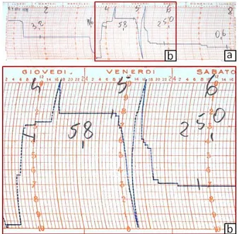
Fig. 1 – a) Printed rainfall reading from Apulian rain-gauge before 1990; b) enlarged view of the pluviogram.
In addition, the pre-1990 Apulian landslide events are now considered after reporting the data from paper (see Fig. 1) on digital sheets. These data are available at the Regional Office of Civil Protection, and a great effort was done to digitalize the
L. PISANOET ALII
238
rainfall readings. So far, ten new events have been collected in the archive despite the large amount of time spent in the print source analyses and in the rain-gauge selection. Furthermore, in order to increase the number of events, sources of information are consulted daily to find new records about landslides events that occur in the study area, in order to achieve in the shortest time possible a consistent number of events.
At the present the catalog consists in 32 rainfall events responsible for the onset of 62 shallow landslides.
AUTOMATED PROCEDURES FOR COLLECTING THE RAINFALL EVENTS
The CNR-IRPI group has developed two automated methods (Melillo et al., 2014; Vessia et al., 2014) to calculate the duration, cumulate and intensity of the rainfall events likely to be responsible for shallow landslide initiation. The two methods are derived from the “expert method” by the CNR-IRPI group (Brunetti et al., 2010) and enable non-expert users to select within the representative rain-gauge readings those portions related to the landslide onset. These two contributions fill the gap in the scientific literature, where so far only expert methods had been proposed using site-specific procedure and parameters to select the rainfall events. Nonetheless, the repeatability of the rainfall selection criteria guarantees a much higher objectivity and enables to compare the worldwide datasets collected in different geographic and climate settings.
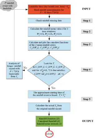
Fig. 2 - A five-step flowchart that describes the automated method to select Duration, Cumulate and Intensity of the rainfall events that are responsible for shallow landslide initiation (after Vessia et al., 2014).
Among the two automated methods above, that proposed by Vessia et al. (2014) is hereafter used. Figure 3 shows the flowchart of the five-step method. It will be used together with the expert method to calculate the new datasets of rainfall data by which tracing the empirical rainfall thresholds for the Apulia Region. The first application of this automated method to the 62 shallow landslides identified in the Daunia Sub-Apennine enables to state that pairs of durations D and cumulates C calculated by means of the automated method correspond to 50% of the pairs calculated by means of the expert method (Fig. 3).
Fig. 3 - Duration vs cumulated rainfall plot for the Daunia Sub-Apennine: red squares are calculated by the automatic method (Vessia et al., 2014), blue diamonds by the expert method (Brunetti et al., 2010).
The two methods select the rainfall events by different criteria:
1) The automated method is based on the minimum difference between two C values in a time span of 48 or 72h;
2) The expert method is based on the minimum rainfall height in a time span of 48h in spring-summer season and 96h in winter-fall season.
In addition to the differences in selecting criteria the automated procedure makes the same choices in similar conditions, while the expert method uses the expert judgement to apply the selecting criteria properly case by case. These main features of the two methods, in these D,E pairs result in higher differences in D values than in C values.
FINAL REMARKS
At present, the number of collected rainfall-induced shallow landslides data do not enable to draw a statistically-significant regional threshold for the Daunia Sub-Apennine. The low density of rain-gauges installed in the investigated territories, combined to the frequent malfunctioning, made the data collection a difficult task, and a time-consuming work. This is especially true for the pre-1990 landslide events. The need to collect precise information in time and space forced to exclude many landslide events, as reported by newspapers and firefighters. Another disadvantage is the strong demographic decrease affecting Daunia (Dragone & Parise, 2014), that
DATA COLLECTION FOR RECONSTRUCTING EMPIRICAL RAINFALL THRESHOLDS FOR SHALLOW LANDSLIDES 239
reduces the possibility to get information on the shallow landslides occurred outside the inhabited areas.
The on-going work, which includes analysis over a wider area, with similar geomorphological and lithological conditions, and a longer time window for collecting landslide data, will hopefully provide new events needed to gain a statistically meaningful dataset for tracing Empirical Rainfall Threshold for the foothill Apennine territories of Apulia and Molise regions.
REFERENCES
Brunetti M.T., Peruccacci S., Rossi M., Luciani S., Valigi D. & Guzzetti F. (2010) - Rainfall thresholds for the possible occurrence of landslides in Italy. Nat. Hazards Earth Syst. Sci., 10, 447–458.
Brunetti, M.T., Peruccacci, S., Antronico, L., Deganutti, A.M., Gariano, S.L., Iovine, G., Luciani S., Luino F., Melillo M., Palladino M.R., Parise M., Rossi M., Turconi L., Vennari C., Vessia G., Viero A., & Guzzetti F. (2015) - Catalogue of Rainfall Events with Shallow Landslides and New Rainfall Thresholds in Italy. In: G. Lollino, D. Giordan, G. B. Crosta, J. Corominas, R. Azzam, J. Wasowski, & N. Sciarra (Eds.), Engineering Geology for Society and Territory, 2, 1575–1579. Springer International Publishing. DOI:10.1007/978-3-319-09057-3_280.
Caine N. (1980) – The rainfall intensity-duration control of shallow landslides and debris flow. Geografiska Annaler, A62, 23–27.
Cotecchia F., Lollino P., Santaloia F., Vitone C. & Mitaritonna G. (2009) – A research project for deterministic landslide risk assessment in Southern Italy: methodological approach and preliminary results. Geotechn. risk and safety, Taylor & Francis, 363-370.
Cruden D.M. & Varnes D.J. (1996) - Landslide types and processes. In: Turner A.K. & Schuster R.L. (Eds.) Landslides: investigation and mitigation. National Academy Press, 36–75.
Dazzaro L. & Rapisardi L. (1996) - Schema geologico del margine appenninico tra il F. Fortore e il F. Ofanto. Mem. Soc. Geologica Italiana, 51 (1), 143-147
Dragone V. & Parise M. (2014) - Analisi socio-demografica del Sub-Appennino Dauno (provincia di Foggia). CNR-IRPI, Bari, Rapporto Interno, gennaio 2014, 20 pp.
Giordan D., Allasia P., Manconi A., Baldo M., Santangelo M., Cardinali M., Corazza A., Albanese V., Lollino G. & Guzzetti F. (2013) - Morphological and kinematic evolution of a large earthflow: The Montaguto landslide, southern Italy. Geomorphology, 187, 61-79.
Loiacono P., Amoruso G., Brunetti M., Dragone V., Guzzetti F., Parise M., Peruccacci S., Trabace M., Vennari C. & Vessia G. (2014) - Soglie pluviometriche per l'innesco di fenomeni franosi alla scala nazionale e regionale: il caso del Sub-Appennino Dauno (Puglia Settentrionale). Geologia
dell'ambiente, 2, 147-150.
Melillo M., Brunetti M.T., Peruccacci S., Gariano S.L. & Guzzetti F. (2014) - An algorithm for the objective reconstruction of rainfall events responsible for landslides. Landslides, 1–10. DOI:10.1007/s10346-014-0471-3. Parise M. (2000) – Risultati preliminari di ricerche sulla
franosità storica dell’Appennino Dauno. CNR-CERIST, Bari, Rapporto Interno n. 64, aprile 2000, 30 pp.
Parise M. (2001) - Landslide mapping techniques and their use in the assessment of the landslide hazard. J. Physics and Chemistry of the Earth, part C, 26/9, 697–703.
Parise M. (2003) – Considerazioni sulla franosità dell’Appennino Dauno (Puglia) sulla base dell’elaborazione di carte di attività delle frane. Quaderni di Geologia Applicata, 10 (2), 133-145.
Parise M. & Wasowski J. (1999) - Landslide activity maps for the evaluation of landslide hazard: three case studies from Southern Italy. Natural Hazards, 20 (2/3), 159–183.
Parise M., Federico A. & Palladino G. (2012) - Historical evolution of multi-source mudslides. In: Eberhardt E., Froese C., Turner A.K. & Lerouil S. (Eds.), Landslides and Engineered Slopes. Protecting Society through Improved Understanding. Proc. 11th Int. Symp. Landslides, Banff (Canada), 3-8 June 2012, 1, 401-407.
Peruccacci S., Brunetti M.T., Luciani S., Vennari C. & Guzzetti F. (2012) - Lithological and seasonal control of rainfall thresholds for the possible initiation of landslides in central Italy. Geomorphology, 139-140, 79-90.
Rossi M., Peruccacci S., Brunetti M.T., Marchesini I., Luciani S., Ardizzone F., Balducci V., Bianchi C., Cardinali M., Fiorucci F., Mondini A.C., Reichenbach P., Salvati P., Santangelo M., Bartolini D., Gariano S.L., Palladino M., Vessia G., Viero A., Antronico L., Borselli L., Deganutti A.M., Iovine G., Luino F., Parise M., Polemio M., Guzzetti F. & Tonelli G. (2012) - SANF: National warning system for rainfall induced landslides in Italy. In: Eberhardt E., Froese C., Turner A.K. & Lerouil S. (Eds.), Landslides and Engineered Slopes. Protecting Society through Improved Understanding. Proc. 11th Int. Symp. Landslides, Banff (Canada), 3-8 June 2012, 2, 1895-1899.
Vennari C., Vessia G., Parise M., Rossi M., Loiacono P., Amoruso G., Trabace M. & Giandonato P. (2013) - Slope movements in Daunia (Apulia): collecting historical events for the definition of rainfall thresholds. Rendiconti Online Societa Geologica Italiana, 24, 322-324.
Vennari C., Gariano S.L., Antronico L., Brunetti M.T., Iovine G., Peruccacci S., Terranova O. & Guzzetti F. (2014) - Rainfall thresholds for shallow landslide occurrence in Calabria, southern Italy. Natural Hazards and Earth System Sciences, 14 (2), 317-330.
Vessia G., Parise M., Brunetti M.T., Peruccacci S., Rossi M., Vennari C. & Guzzetti F. (2014) - Automated reconstruction of rainfall events responsible for shallow landslides. Natural Hazards and Earth System Sciences, 14 (9), 2399-2408.
V Congresso Nazionale AIGA
(Associazione Italiana di Geologia Applicata e Ambientale)
Cagliari, 29-30 Aprile 2015
RENDICONTI Online
della
Società Geologica Italiana
Rendiconti Online della Società Geologica Italiana
V
ol. 35 (2015)
- pp. 1-299
.
ROMA
SOCIETÀ GEOLOGICA ITALIANA
2015
www.socgeol.it
Volume 35 - Aprile 2015
ISSN 2035-8008
RENDICONTI Online della Società Geologica Italiana
Volume 35 - Aprile 2015
RENDICONTI ONLINE DELLA SOCIETÀ GEOLOGICA ITALIANA Direttore responsabile: DOMENICO CALCATERRA
Iscrizione ROC 18414.
Pubblicato online il 30 aprile 2015.
Indice
SHORT NOTES
Edited by: Gabriele Uras
main partner