3D MODELLING IN THE AGORA OF SEGESTA:
TECHNIQUES AND DATA INTERPRETATION 1
1. Introduction
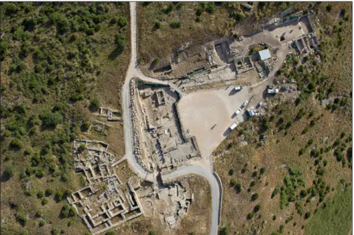
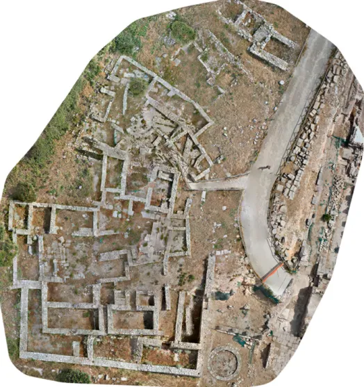
In 2001 the Laboratorio di Scienze dell’Antichità (LSA) of the Scuola Normale Superiore, in collaboration with the Dipartimento di Civiltà e Forme del Sapere of Pisa University, restarted the archaeological investigations in the agora of Segesta (TP) (Figs. 1-2). During the very last years, the research in the Segestan public square could take advantage of the scientific and techni-cal support of the Laboratorio di Disegno e Restauro, at the Dipartimento di Civiltà e Forme del Sapere (LADIRE), and of the DreamsLab, at the Scuola Normale Superiore.
The excavations brought to light a great part of the buildings which bordered the ancient public square along the N, W, and E sides, in addition to those that were set up immediately S-W of the agora (Abate, Cannistraci 2012; Ampolo, Parra 2012; Angeletti 2012; Facella, Olivito 2012).
In the area of the public square, the most interesting acquisitions of planimetric, architectural, and monumental nature are related to a large stoa with two projecting wings, which was built in the Late-Hellenistic period (end of the 2nd century BC) with the aim of delimiting three sides of the agora.
The study of the architectural elements, which have been discovered during the excavations of the Late-Hellenistic stoa at Segesta, led to the for-mulation of a quite trustworthy and complete hypothetical reconstruction of the vertical development of the building (Abate, Cannistraci 2012).
The portico was a two-storey building. On a three steps stylobate, a 6,6 m high doric colonnade (from the upper face of the stylobate to the up-per face of the geison) was set up; at the second floor there was a 4,3 m ca.
1 We would like to thank Prof. Carmine Ampolo, Director of the Laboratorio di Scienze dell’Antichità of the Scuola Normale Superiore, and Prof. Maria Cecilia Parra, of the Department of Civiltà e Forme del Sapere at Pisa University, who allowed us to test techniques and methods, which we illustrate in this paper, during the archaeological investigations in the agora of Segesta. Thanks to Dr. Agata Abate and Dr. Oriana Silia Cannistraci, supervisors of the architectonic study of the Segestan stoa, for giving us useful information on the portico and for the profitable discussions on the issues presented here. Thanks to Prof. Vincenzo Barone, Director of DreamsLab, for allowing us to use tools and equipments available at DreamsLab, and to Dr. Daniele Licari and Dr. Niccolò Albertini who used the acquired data and 3D models, which have been elaborated at the Laboratorio LADIRE, in order to create virtual applications to be visualized within the CAVE at DreamsLab. Finally, we would like to thank Cesare Cassanelli, of the Laboratorio di Scienze dell’Antichità, and Andrea Palla, of the Scuola Normale Superiore, who supervised the topographic survey and the flight operations of the RPAS. Although this paper results from a common work, paragraphs 1 and 3 are by Riccardo Olivito, and paragraph 2 is by Emanuele Taccola.
Fig. 1 – Plan of the agora of Segesta (by C. Cassanelli).
high ionic colonnade, which was completed with symae and lion protome dripstones. The total height of the stoa was 11 m ca.
The Segestan portico was two-aisled, with an intermediate row of oc-tagonal pilasters: the external aisle was 5,8 m ca. deep; the internal one was 5,5 m ca. in depth. The N side of the building, the longest one, was 82 m long ca. The W side, which has been completely investigated, was 20 m long ca.; finally, although not totally excavated, the E side, which was probably 20 m long ca.
As to the internal planimetric organization, nowadays available data seem to demonstrate that the northern side of the stoa did not have rooms along the back wall. On the contrary, along the rear wall of the portico, some stone arches had been built in order to sustain and strengthen those points where the rock had been cut before the construction of the stoa (Facella, Olivito forthcoming).
A quite more articulated situation is that of the N-W corner of the building, where a small stair leading to the upper floor was set up.
Finally, the most recent research in the E wing of the portico allowed us to verify the presence of a large room (so-called “Ambiente I”), whose main entrance was marked by pilasters with semi-columns, and whose func-tion is still unknown. Nevertheless, the presence of burnt remains along the walls of the room, probably to be related to wooden shelves, could suggest an identification of the so-called “Ambiente I” with an archive or a documents depository (Abate, Cannistraci forthcoming). Although very interesting and fascinating, this identification is hypothetical, and further investigations would be necessary in order to clarify function and nature of this room.
Still in the eastern wing, south of the “Ambiente I”, a threshold has been discovered, indicating with no doubt the presence of at least one more room in this part of this ala.
Within this articulated monumental complex, during the very last years it has been possible to test and use new photogrammetric techniques, which allowed a significant improvement in the data acquisition phase, in the graphic documentation, and in the following elaboration processes.
2. 3D modeling: techniques, procedures, approaches
The 3D models employed have been realized with computer graphics and close-range photogrammetry (Albertini et al. 2014), both terrestrial and aerial.
The distinction between the two approaches is obvious: in the first case, although we rely on measured data and consolidated studies of the elevations, we reconstruct the object as we presume it had to appear in a given historical
period (Taccola 2012). In the second case, we use reality-based procedures in order to document the object in its current condition.
2.1 3D reconstruction of the agora
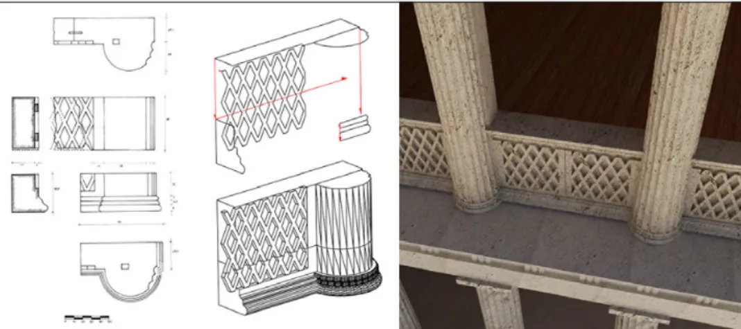
As previously noted, the excavation activity in the agora of Segesta led to the discovery of a large part of the architectural apparatus of the public square, still found in connection despite the collapse of the structures. Many elements preserve their original position, while others were re-used in the buildings of later historical periods. The drawings of these architectural ele-ments have been carried out so far with traditional manual techniques on paper. They are vectorized after being acquired with a 2D scanner, and sub-sequently they are turned from simple polylines into 3D solids and surfaces with commands as extrusion, revolution, loft and sweep (Xuetao, Wonka, Razdan 2009) (Fig. 3).
The study of the elevations, which consists in the comparison of meas-urements and ratios of proportions of the surviving structures with similar examples best preserved in Sicily and in the Mediterranean area (Abate, Cannistraci 2012), allows us to extract useful information on architectural volumes, from which we get reliable data for the 3D reconstruction of the monumental complex. The elements that are repeated in the development of the building (such as the columns) are drawn only once, copied to the cor-responding positions, and adjusted in the case, using as a basis the general planimetry of the excavation area, previously georeferenced (Fig. 4). Simul-taneously, the digital model of the surrounding environment (DTM) is gen-erated, by interpolating the contour lines extracted from the archaeological cartography of Segesta (Camerata-Scovazzo 1996), to place properly and contextualize the reconstruction of the agora.
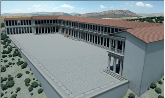
Finally, the whole model is texturized by projecting on the 3D surfaces the images, acquired in the field, of materials employed for the construction of the building, specifically edited and resized, in order to confer an appear-ance of verisimilitude (Fig. 5).
2.2 Close-range photogrammetry
The photogrammetry is the science that, using passive optical sensors (i.e. cameras), allows to obtain three-dimensional metric information by means of the interpretation and the measurement of photo images (Mikhail, Bethel, McGlone 2001). As far as the agora of Segesta is concerned, a semi-automatic procedure called Structure from Motion (SfM) was performed.
The workflow normally involves the following steps: camera calibra-tion, images acquisition and pre-processing, tie points extraccalibra-tion, images orientation, point cloud generation, generation of the mesh, and texturing
Fig. 3 – 3D models derived from 2D drawings (on the left, 2D drawings by A. Abate and O.S. Cannistraci).
Fig. 4 – 3D reconstruction of the agora overlaid on 2D georeferenced planimetry (2D planimetry by C. Cassanelli).
(Remondino, El-Hakim 2006; Barazzetti, Remondino, Scaioni 2010; Russo, Remondino 2012) (Fig. 6).
Depending on the software used, it is necessary to calibrate the cam-era in advance. Calibration (Brown 1971; Remondino, Fraser 2006) is a procedure for calculating the internal orientation parameters of the camera (focal length, principal point on the sensor and other parameters useful to solve more systematic errors, e.g. those related to the distortion of the lens).
At the stage of image orientation, the algorithm detects up to 40,000 tie points per photo, leading to the creation of a sparse point cloud. Once the point cloud is turned from dense into sparse, we can create the geometric structured model (mesh), of which it is possible to set some parameters, such as the quality of the model and the total number of triangles.
The last operation involves the generation of photorealistic texture, that allows to project onto the shaded surface a blend of the images taken to create the 3D object. The resulting model must be scaled and oriented, by setting a known distance or entering known coordinates both absolute and relative, using ground control points (GCPs) appropriately distributed on the survey area and measured with a total station or a GNSS.
In the context of close-range terrestrial photogrammetry a series of convergent shots is acquired, by moving around the object to be surveyed, maintaining the same distance and with an overlap between the images of 60-80%.
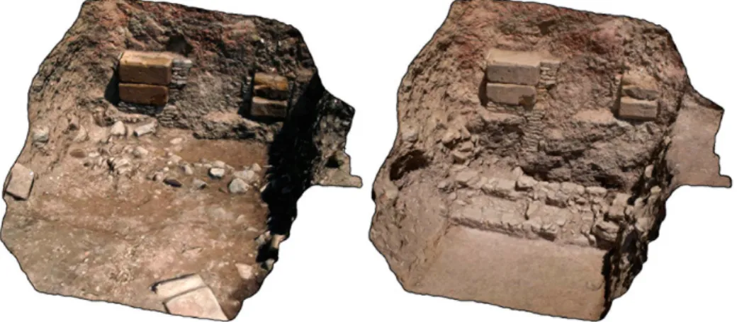
Through this approach, we developed the 3D model of the central part of the North stoa, and that of the N-E corner of the stoa. In the first case, we wanted to evaluate the amount of material removed among the excavation campaigns 2012 and 2013 (Fig. 7), while, in the second case, to overlay the reality-based model with the one obtained from computer graphics (Fig. 8).
The survey by RPAS (Remotely Piloted Aircraft Systems) (Eisenbeiss 2009; Sauerbier, Eisenbeiss 2010; Chiabrando, Lingua, Piras 2013) requires further preliminary steps. The first and most important one is the flight planning. The operator creates the flight configuration (grid or circu-lar) on georeferenced images supplied by a dedicated application, setting additional parameters, that are sent to the drone via datalink: the speed of the RPAS, the flight altitude, the distance between the waypoints, the retention time on the waypoint, the angle of sight of the camera and the shooting mode (e.g. at each waypoint, or every few waypoints, or every few seconds).
It is useful to perform a pre-flight to check for the correctness of the plan designed. In fact, even using georeferenced images, it is difficult to place it correctly: the reason of this inaccuracy is linked to the resolution of the
Fig. 5 – General view of the agora in its environment.
Fig. 6 – Photogrammetric pipeline, from images acquisition to textured model.
image, to its update and to the intrinsic error of the GNSS receiver mounted on the RPAS.
Once all the parameters are verified, it is possible to begin the survey. During the flight, the RPAS proceeds automatically following the loaded set-tings, even if the experience of a specialized operator is necessary to manage the takeoff and landing and in any case to overcome anything unexpected, which can be related to various factors (wind, vegetation, infrastructure, loss of GNSS signal, etc.). It is advisable to flight under optimal conditions of wind and light-shadow, and it is essential that the area to be surveyed is clear of the weeds that cover the archaeological ruins, in order to limit the visibility
Fig. 7 – Central part of the North stoa: reality-based model before (left) and after the removal of the layer of collapse.
Fig. 8 – N-E corner of the stoa: 3D reconstruction overlaid on the reality-based model.
issues that can potentially invalidate the result of the operation. The model of camera mounted on the flying platform is another factor to consider, because, if too heavy, it can severely limit the performance of the batteries.
Fig. 9 – Upper terrace: orthophoto realized with survey by RPAS.
As an area subject to relief by RPAS, more specifically a MikroKopter Hexacopter, we chose the upper terrace of the agora, a portion of the site which was already explored and inaccessible to tourists. The choice fell on this area because it is characterized by a complex superposition of structures related to different historical phases, and therefore very interesting from an experimental point of view. Two flights were needed to cover the total area, which required 175 vertical images from a height of 12 m (Fig. 9).
3. Data interpretation
The use of photogrammetry, both terrestrial and aerial, allowed us to obtain more efficient and rapid data of the investigated areas. Although we have been using these techniques only since 2012, they led to a noteworthy improvement of the relation between the time that we need for the documenta-tion phase and the results that we can achieve. In addidocumenta-tion to this, the digital acquisition of data, and their elaboration, allowed us to pursue different visualization modalities.
As to the reality-based models, the most interesting application is that of a real-time monitoring of the fieldwork activities, to be realized thanks to the photogrammetric documentation of the different phases of the excavation. The possibility to carefully record the development of the digging activity is obviously followed by the opportunity to go over the different moments of an excavation in a more rapid and accurate way, to draw information (measurements, distances, position of the finds) which could have been ignored during the fieldwork, and to verify, even ex-post, issues not correctly documented during the field activity.
A very interesting application of these techniques in the agora of Segesta concerns the exam of the collapse layers of large portions of walls, and the analysis of the stratigraphic deposit. In this sense, a significant example could be represented by the stone arches behind the rear wall of the stoa. In fact, at the time of the excavation, both the collapsed arches and a large portion of the rear wall were still in perfect connection (Facella, Olivito forthcoming). As a result, the photogrammetry of the excavated area, of the different archi-tectural elements, and of the parts of the wall that were still in their original collapse position, allowed us to carefully record all the structural elements, and to use dedicated software in order to create a virtual simulation of the collapse dynamics which involved this part of the stoa at the beginning of the 3rd century A.D., i.e. when the agora was gradually abandoned, probably due to an earthquake (Gagliardi, Parra 2006).
The use of photogrammetry has a significant impact even in the analysis of the original plan of the stoa and its monumental organization. The study of the architectural elements (Abate, Cannistraci 2012), in addition to the exam of the digitally collected data, allowed us to suggest a hypothetical three-dimensional restitution of the stoa in which the whole reconstruction is not invalidated by the few elements with a weak reliability (Taccola 2012) (Fig. 6).
It is indeed necessary to note that the process of elaboration of the measured data, of the traditional 2D drawings, and of the photogrammetric acquisitions, do not aim at creating a complete, definitive, and unchangeable reconstruction of the stoa. On the contrary, we pursue a more open and versatile theoretical approach, whose main goal is to create a “simulation” (Clark 2010) of the original aspect of the building. This kind of simulation,
moving from concrete data, will allow the formulation of integrative sug-gestions (e.g. those based on comparisons with similar monuments) which could be easily modified and updated on the basis of results and acquisitions of the fieldwork activity.
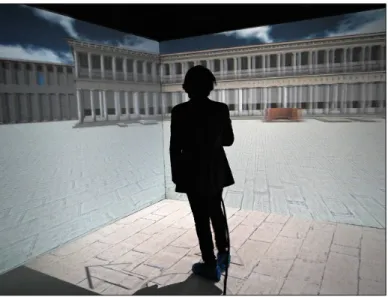
Obviously, from a scientific point of view, the most immediate con-sequence of this “simulation” is to allow a more accurate and articulated visualization of the agora and the stoa of Segesta, and to continuously verify and modify the reconstructive hypothesis. Nevertheless, the most interesting potentiality of the 3D reconstruction project of the agora of Segesta is that resulting from the collaboration with the DreamsLab of the Scuola Normale Superiore. In this sense, a key role is played by the possibility to use the ap-plication which has been created for the Cave Automatic Virtual Environ-ment (CAVE) (Fig. 10) and which has been recently presented at the Athenian conference “Science and Technology for the Safeguard of Cultural Heritage in the Mediterranean Basin” (Albertini et al. 2014).
The opportunity to physically interact with the 3D model of the stoa and, more generally speaking, of the agora, makes it possible to drastically in-crease the level of affordance between scholars/viewers and three-dimensional simulation, and to verify with a completely new approach issues which can be hardly investigated by simply using 2D models and traditional methods of visualization and analysis.
Fig. 10 – The 3D simulation of the agora of Segesta within the CAVE at the DreamsLab (courtesy of the DreamsLab of the Scuola Normale Superiore).
We would like to call the attention on issues like those concerning physi-cal and spatial relations between objects and monumental context, internal and external visibility, relation between open and closed spaces, lighting inside the building (as to the reproduction of the internal lighting, both natural and arti-ficial, see Taccola 2012, 288). These topics can be fully investigated through an “immersion” in the simulated model to be realized within the CAVE. This kind of experience will make the viewer better perceive distances between two or more objects, allowing him to think about levels of visibility of different kinds of documents (e.g. sculptures, inscriptions, architectural decorations).
Besides, very interesting consequences concern the modalities of pres-entation of the investigation results. In fact, the elaborated model makes it possible to use different kinds of visualizations (sections, axonometry, frontal, lateral, and rear view) or to enlarge details with no changes in the levels of definition and resolution of the global view.
In the near future, collaboration between LSA, Department of Civiltà e Forme del Sapere, LADIRE, and DreamsLab will be devoted to the develop-ment and impledevelop-mentation of tools and methods in order to improve the virtual simulation of the agora of Segesta. In this sense, it is necessary to remind the ReShaPe research project, recently submitted to the Italian Ministerial SIR Programme (Scientific Independence of young Researchers). In addition to one of its main goals, i.e. that of promoting the progress of our knowledge of the Segestan square and its buildings, ReShaPe aims at defining a new set of tools and applications, to be used also on portable and wearable devices, that could stimulate a significant advancement in the modalities of on-site visualization and querying of digital data and virtual simulations.
Riccardo Olivito Scuola Normale Superiore, Pisa
Emanuele Taccola
LADIRE, Laboratorio di Disegno e Restauro Università degli Studi di Pisa
REFERENCES
Abate A., Cannistraci O.S. 2012, La stoa Nord dell’agora di Segesta: alcune note preliminari
sull’elevato architettonico dell’ala Ovest, in Ampolo 2012, 305-319.
Abate A., Cannistraci O.S. 2013, Agora. Analisi architettonica dell’ingresso monumentale
all’ambiente I della Stoa Nord, «Annali della Scuola Normale Superiore di Pisa», 5,
2, 29-48.
Albertini N., Barone V., Legnaioli S., Licari S., Taccola E., Brogni A. 2014, The agora
of Segesta in immersive virtual environments, in Proceeding of the 6th International
Congress “Science and Technology for the Safeguard of Cultural Heritage in the Medi-terranean Basin” (Athens 2013), 1, Roma, Valmar, 299-304.
Ampolo C., Parra M.C. 2012, L’agora di Segesta: uno sguardo d’assieme tra iscrizioni e
monumenti, in Ampolo 2012, 271-285.
Angeletti V. 2012, Nell’agora di Segesta: un contributo sui monumenti minori, in Ampolo 2012, 321-326.
Barazzetti L., Remondino F., Scaioni M. 2010, Automation in 3D reconstruction: Results
on different kinds of close range blocks, «International Archives of Photogrammetry,
Remote Sensing and Spatial Information Sciences», 38, 5, 55-61.
Brown D.C. 1971, Close-range camera calibration, «Photogrammetric Engineering», 8, 855-866.
Camerata-Scovazzo R. (ed.) 1996, Segesta I. La carta archeologica, Palermo, Sellerio. Chiabrando F., Lingua A., Piras M. 2013, Direct photogrammetry using UAV: Tests and
first results, «International Archives of Photogrammetry, Remote Sensing and Spatial
Information Sciences», 40, 81-86.
Clark J.T. 2010, The Fallacy of Reconstruction, in M. Forte (ed.), Cyber Archaeology, BAR International Series 2177, Oxford 2010, pp. 63-73.
Eisenbeiss H. 2009, UAV Photogrammetry, «IGP Mitteilungen», 105, Zurich.
Facella A., Olivito R. 2012, Agora di Segesta. L’area della stoa sud-occidentale, in Ampolo 2012, 291-304.
Facella A., Olivito R. 2013, Segesta. Area della Stoa Nord (SAS 4; 2012), «Annali della Scuola Normale Superiore di Pisa», 5, 2, 10-14.
Gagliardi V., Parra M.C. 2006, Ceramiche africane dal Foro di Segesta: dati preliminari, in A. Akerraz, P. Ruggeri, A. Siraj, C. Vismara (eds.), L’Africa Romana. Mobilità
delle persone e dei popoli, dinamiche migratorie, emigrazioni ed immigrazioni nelle province occidentali dell’Impero romano, Atti del XVI Convegno internazionale di studi sull’Africa Romana (Rabat 2005), Roma, Carocci editore, 1615-1628.
Mikhail E.M., Bethel J.S., McGlone J.C. 2001, Introduction to Modern Photogrammetry, New York, Wiley.
Remondino F., El-Hakim S. 2006, Image-based 3D modelling: A review, «The Photogram-metric Record», 21, 115, 269-291.
Remondino F., Fraser C. 2006, Digital camera calibration methods: Considerations and
comparisons, «International Archives of Photogrammetry, Remote Sensing and Spatial
Information Sciences», 36, 5, 266-272.
Russo M., Remondino F. 2012, Laser Scanning e fotogrammetria: strumenti e metodi di rilievo
tridimensionali per l’archeologia, in G.P. Brogiolo, D.E. Angelucci, A. Colecchia,
F. Remondino (eds.), Teoria e metodi della ricerca sul paesaggio d’altura, Mantova, SAP, 141-170.
Sauerbier M., Eisenbeiss H. 2010, UAVS for the documentation of archaeological excavations, «International Archives of Photogrammetry, Remote Sensing and Spatial Information Sciences», 38, 5, 526-531.
Taccola E. 2012, Ricostruzioni 3D per l’agora di Segesta, in Ampolo 2012, 287-289. Xuetao Y., Wonka P., Razdan A. 2009, Generating 3D building models from architectural
drawings: A survey, «Computer Graphics and Applications, IEEE», 29/1, 20-30.
ABSTRACT
The aim of this paper is to illustrate the techniques used for data collection, elaboration and interpretation during the archaeological investigation in the agora of Segesta, conducted by the Laboratorio di Scienze dell’Antichità (LSA) of the Scuola Normale Superiore and the Laboratorio di Disegno e Restauro (LADIRE) of the Dipartimento di Civiltà e Forme del Sapere of Pisa Univer-sity. The use of close-range photogrammetry, both terrestrial and aerial, combined with traditional
drawing techniques, allowed us to improve the quality and amount of data collected for scientific purposes. As a result, the analysis of the archaeological stratigraphy, and especially the examination of structures and architectural elements, benefitted from a wider and more detailed collection of graphic data and information concerning the ancient site of Segesta. On the one hand, the use of terrestrial photogrammetric techniques, such as the so-called Structure from Motion (SfM), allowed us to obtain 3D models of the excavated area. At the same time, by using RPAS (Remotely Piloted Aircraft Systems) we started an up-to-date survey of the whole site. Using these new techniques, we were able to develop and improve the digital acquisition of data and create 3D models of the elements discovered and of the whole agora. Moreover,, thanks to the fundamental collaboration of the DreamsLab of the Scuola Normale Superiore, it was possible to achieve a virtual simulation of the public square of Segesta and of the most important buildings surrounding the agora. This virtual simulation of the agora in augmented reality, and the opportunity to visualize and utilize it within the Cave Automatic Virtual Environment (CAVE), will certainly make it possible to improve archaeological research and data dissemination, presentation and communication.