T.C.
KÜLTÜR VE TURİZM BAKANLIĞI
Kültür Varlıkları ve Müzeler Genel Müdürlüğü
25-29 MAYIS 2009
DENİZLİ
27.
ARAŞTIRMA SONUÇLARI
TOPLANTISI
3. CİLT
T.C. Kültür ve Turizm Bakanlığı Yayın No : 3250/3
Kültür Varlıkları ve Müzeler Genel Müdürlüğü Yayın No: 143/3
YAYINA HAZIRLAYANLAR
Dr. Haydar DÖNMEZ
Candaş KESKİN
Kapak ve Uygulama
Necdet ÇELİKTAŞ
ISSN: 1017-7663Kapak Fotoğrafı:
Harun ÖZDAŞ
“Ege-Akdeniz Bölgesi Sualtı Araştırması 2008 Yılı Çalışmaları” “Datca Yarımadası Gazze batığı sepet formlu amphoralar”
Not : Araştırma raporları, dil ve yazım açısından Klâsik Filolog Dr. Haydar Dönmez tarafından denetlenmiştir. Yayımlanan yazıların içeriğinden yazarları sorumludur.
İsmail Aygül Ofset Matbaacılık San. Tic. Ltd. Şti.
İÇİNDEKİLER
Ender VARİNLİOĞLU, Pierre DEBORD
2008 Yılı Karia Araştırmaları ...1 Martin BACHMANN
2008 Yılı Oinoanda Çalışmaları ...9 Hamdi ŞAHİN
Dağlık Kilikia Yerleşim Tarihi ve Epigrafya Araştırmaları 2008 ...17 Hugh ELTON, John HALDON , Jim NEWHARD , Sean LOCKWOOD
Avkat Archaeological Project, 2007-2008 ...29 Emel ERTEN, Murat ÖZYILDIRIM, Tuna AKÇAY
Olba 2008 Yılı Yüzey Araştırması ...51 Füsun TÜLEK
Osmaniye Arkeolojik Yüzey Araştırması 2008 Yılı Çalışması ...69 Peter RUGGENDORFER
Die Ergebnisse Der Feldforschungen in Alinda 2008 ...83 Ümit AYDINOĞLU
Erdemli Ve Silifke Arasında Kentleşme ve Tarımsal Organizasyon
2008 Yılı Araştırması ...97 S. MAZZONI , A. D’AGOSTINO , V. ORSI
Kuşaklı 2008 Survey Season (Yozgat-Sorgun) 1st Preliminary Report ...109 Atilla ENGİN
Sivas İli 2008 Yılı Yüzey Araştırması ...129 A. Osman UYSAL
Çanakkale İli Ortaçağ ve Türk Dönemi Yüzey Araştırması (2008) ...151 Mustafa ŞAHİN, İ. Hakan MERT, Derya ŞAHİN
Keles Yüzey Araştırması, 2008 ...163 Mustafa ŞAHİN, Serkan GÜNDÜZ
Karl ST ROBEL, Christian GERBER, Gabriele KOINER
Uluslararası Tavium Projesi: 2008 Yılı Araştırmaları ...187 Günder VARİNLİOĞLU
Geç Antik Dönemde Silifke Kırsalında Yerleşim:
2002-2007 Yılları Yüzey Araştırması Sonuçları ...201 Winfried HELD, Gonca CANKARDAŞ ŞENOL, Ahmet Kaan ŞENOL
2008 Yılı Bybassos Araştırması ...215 Harun TAŞKIRAN, Metin KARTAL
2008 Yılı Ilısu Baraj Gövdesi Alanı Yüzey Araştırması...233 Poul PEDERSEN
Report of The Turkish-Danish Investigations at
Ancient Halikarnassos (Bodrum) in 2008 ...245 Kadir PEKTAŞ, Gülsen BAŞ
Bitlis ve Çevresi Yüzey Araştırması, 2008 ...259 Şengül AYDINGÜN, Emre GÜLDOĞAN, Volker HEYD, Hakan ÖNİZ
2008 Yılı İstanbul Tarih Öncesi Çağlar Yüzey Araştırması ...273 Enver AKIN
Adıyaman Gaziantep ve Şanlıurfa Müzeleri’nde Yer Alan
Roma Dönemi Ticaret Malları ...289 Fikri KULAKOĞLU, Kutlu EMRE, Ryoichi KONTANİ, Hiroomi TS UMURA, Sabahattin EZER
Kayseri Arkeolojik Yüzey Araştırması Projesi (Kayap)
2008 Yılı Çalışmaları Sonuç Raporu ...305 Ann E. KILLEBREW, Gunnar LEHMANN
Summary of the 2008 Cilicia Survey (İskenderun Bay Region) ...319 İsa KIZGUT
Beydağları Yüzey Araştırmaları 2008 ...339 Abuzer KIZIL, İsmail Ernur ÖZTEKİN
2008 Yılı Muğla İli, Milas İlçesi İle Ören ve Selimiye Beldeleri’nde
V
Gülçin İLGEZDİ BERTRAM, Jan-K. BERTRAMİlk Tunç Çağı Ankara Bölgesi Araştırmaları (Odtü Yüzey Araştırması 2008 ve Ahlatlıbel Buluntuları)
Zur Frühbronzezeit in Der Ankara-Region (Odtü-Survey 2008 und
Aufarbeitung Der Ahlatlıbel-Funde) ...385 Ferudun ÖZGÜMÜŞ
2008 Yılı İstanbul Sur İçi Arkelojik Çalışmaları ...397 Hasan BAHAR
Konya ve Karaman İlleri ve İlçelerinde Arkeolojik Yüzey Araştırması, 2008 ...415 Osman AYTEKİN
Artvin-Erzurum İlleri Çoruh Vadisi’ndeki Tarihî Yollar ve
Kültür Varlıkları Yüzey Araştırması, 2008 ...435 Tunç SİPAHİ, Tayfun YILDIRIM
2008 Yılı Çankırı ve Çorum İlleri Yüzey Araştırması ...447 Michael HOFF, Rhys TOWNSEND, Ece ERDOĞMUŞ
The Antiocheia Ad Cragum Archaeological Research Project:
109
The first archaeological campaign in Kuşaklı Höyük (Sorgun West-Yozgat)1was primarily intended to furnish basic information on the chronological development and structure of the site of Kuşaklı Höyük, and investigate its environment and archeological landscape (Fig. 1).2 Thanks to its emerging
position on the plain, the site attracted the attention of scholars, beginning with E. Forrer in 1926 and H.H. von der Osten in 1927 who recognized the well-dressed stones on the lower terrace as a Hittite gateway, and by P. Meriggi at the time of his « Viaggi anatolici ».3 The first archaeological survey
1 We wish to express our gratitude to Orhan Düzgün, Director of the General Directorate of Cultural Heritage and Museums for his invaluable support; we are especially thankful to Nilüfer Babacan of the General Directorate and the representative Erkan Yılmaz, of the Museum of Aydın, for their generous and always wise help. We are grateful to the Director of the Yozgat Museum, and his staff together with the Sorgun District Governor for their kind welcome and aid during our staying in the region. Special thanks are due to Murat Akar, PhD student at Florence, and Ekin Demirci, student at the Bilkent University, who working with us in the field also provided their valuable help on many questions. The guardian of the Kerkenes house, Mehmet Ergiyas, and the Muhtar of Şahmuratlı, Osman Muhratdagı, made our stay in Kerkenes easy in every way possible. We are indebted to Prof. Tangianu, Director of the Istituto Italiano di Cultura for her support and interest. Financial support for this campaign has been granted by the University of Florence and the Foundation OrMe Oriente Mediterraneo.
2 Components of the 2008 campaign were: archaeologists : A. D’Agostino, V. Orsi, M. Akar, B. Chiti, S. Soldi, hittitologists : G. Torri, C. Corti, A. Archi; topographers : G. Carpentiero, E. Mariotti, draughstman : S. Martelli. Students, G. Della Lena Guidiccioni, E. Demirci, D. Fossati, F. Barsacchi, M. Di Marcoberardino, R. Ranieri.
3 Forrer, E. 1927, “Ergebnisse einer archäologischen Reise in Kleinasien”, 1926, Mitteilungen
der Deutschen Orient Gesellschaft,65, 1927: 33 (with the name of Kusachakly); von der Osten
H.H., “Explorations in Hittite Asia Minor 1927-1928 ”Oriental Institute Publications 6), Chicago 1929 : 37,38, Figs. 31-32 ; Meriggi P., “Ottavo e ultimo viaggio anatolico ”, Oriens Antiquus 10,1971 : 62, Pl. X.1-2 (with the name of Uçaklı).
KUŞAKLI 2008 SURVEY SEASON (YOZGAT-SORGUN)
1ST PRELIMINARY REPORT
S. MAZZONI,
A. D’AGOSTINO,
V. ORSI
110
of the site of Kuşaklı was realized by G. D. and M.E.F. Summers4 in
1993-1994 in the frame of the Kerkenes Project and provided pottery from a limited surface collection supporting a date of the settlement in the 2nd millennium. Furthermore, a well dressed stone with clear Hittite features was reported from the nearby village of Aşağı Karakaya Köy and was attributed to Kuşaklı. These materials5 and the location of Kuşaklı in the vicinity of Kerkenes Dağ,
led to its identification with the town of Zippalanda, which was one of the cult centres of the Storm-god and, as suggested by O.R. Gurney,6 one day’s
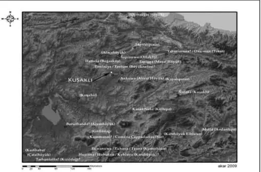
journey from Ankuwa, identified with Alişar Höyük by I.J. Gelb (Fig. 2).7
The first survey was mainly aimed at investigating the site and obtaining information on its morphological and cultural characteristics. Five operations were planned: 1. mapping the contour of the höyük with GPS; 2. geomagnetic surveying of the relevant sectors of the site ; 3. collecting sherds and artifacts on a grid system related to the geomagnetic survey; 4. furnishing a preliminary analysis of the pottery assemblage from the site ; 5. starting the exploration of the Kuşaklı Höyük archaeological landscape.
4 Without the initial encouragement and support given to the application by G.D. and M.E.F. Summers and their generous scientific guide, our work would not have reached its goal. No less appreciated by our team was their hospitality in the Kerkenes Mission house which made our permanence a fully enjoyable experience. See Summers G. D. and M.E.F. and Ahmet K., “The Regional Survey at Kerkenes Dağ: An Interim Report on the Seasons of 1993 and 1994”
Anatolian Studies, XLV, 1995: 43-68.
5 We must also mention a Hittite tablet, found in 1960 supposedly on the site of Taşlık Höyük, 2 km SW of Kuşaklı, and currently being studied by C. Corti; this might have come from Kuşaklı, Taşlık being a small mound of LC and EB periods. On the tablet see also Summers, Ahmet, op. cit.: 55.
6 Gurney O. R., “The Hittite Names of Kerkenes Dağ and Kuşaklı Höyük”, Anatolian Studies, XLV, 1995: 69-71. In a religious festival the Hittite king, moving from Hattusha, reached Haitta and Mount Puskurunuwa. From there, the king arrived on the third day in Zippalanda, where he worshiped Mount Daha (probably Kerkenes Dağ). The next day, he reached Ankuwa. Kerkenes Dağ must have been a landmark for anyone moving from the mountains south of Hattusha.
111
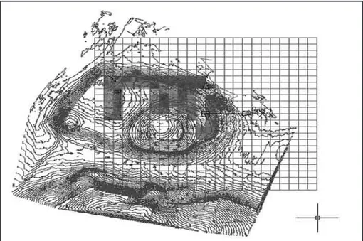
1. Topography and GPSE. MARIOTTI The GPS Differential (Trimble 5700) and AutoCAD and software Trimble recording has been directed to offering a complete contour mapping and a digital model (DTM, Digital Terrain Model) of the site, (Fig. 3) the virtual rendering of the surface of the tell in 3D, the relief of the surface structures and the localisation of the findings collected in the survey. The site of Kuşaklı Höyük covers 10 ha. and the mound 2 ha, having a surface of 400m E-Wx240m. NS. The site is constituted by three distinct parts: a central mound, a large extended terrace and a low, slightly sloping base. The central mound is conical with the summit slightly concave; the outer more elevated circuit might be determined by a line of fortifications; large well-dressed stones are in fact visible on the surface on the NE. The mound lies on the SE corner of the terrace; this is a plateau of irregularly squared shape. The contour mapping provides evidence of a large depression in the central part of the outer town west. In the north-eastern and north-western corners of the terrace two distinct higher points might be related to structures such as casemate walls, while the slight ravines adjacent to the east might indicate the presence of two axial and opposite gates. The outer base is also squared as an outer extension of the low terrace. On the NE side of this terrace several well dressed blocks emerge on the surface, possibly belonging to a substantial building which must have faced the river to the east.
2. The Geo-Magnetic Survey
G. CARPENTERO The geo-magnetic resistance survey has been conducted over the NE, N and NW outer town on a total surface of 3,04 ha. through a Gradiometer Fluxgate FM36 of Geoscan Research with a grid of 76 squares of 20 by 20 m, a 0.50 m. sample interval, 1m of transversal interval, 800 lectures for square resulting in a total of 60.800 lectures. The preliminary images clearly show different buildings on the N and NW sides (Fig. 4). On the outer terrace and
112
the slope outside the outer town, walls and structures are clearly visible, probably because destroyed by fire; numerous melted bricks, clay and sherds have been in fact collected on the surface of this area. In most of the lower town, instead, anomalies are less visible possibly owing to the greater depth of the underlying structures covered by a high deposit.
3.Analysis Of The Artefacts
A. D’AGOSTINO8, V.ORSI9
a. Collecting Method
Systematic investigations have so far concerned the north-eastern portion of the terrace at the foot of the central mound and its low, slightly sloping base facing the river; this is an area characterized by the presence of the above-mentioned stone blocks, visible on the surface. An intensive collection of all artefacts referenced to the main topographical or surveyed units was at first aimed at achieving precise spreadsheets of the different categories of findings and analysing their functional and chronological patterns of distribution. Post-depositional anthropic and natural activities may certainly have undermined the reliability of our evidence; agricultural activities, erosion but also the many previous visits to the site with often extensive collection of materials might have modified the consistency and original deposition of the artefacts. Actually, it is more correct to define our activity as a sort of ‘re-surveying’ of the site.
Sampling and coverage were established with the use of a grid system related to the geomagnetic survey in order to connect both form of data. Two areas of the north-eastern edge of the terrace were completely covered: the flat top of the terrace and its low slope descending gradually to the river bank valley. Our field method involved sampling survey units established on the basis of the morphology of the surface and the general topographical grid.10 The intensive
8 Paragraphs a, c, d. 9 Paragraphs b, d.
10 The CAD registration and the typological distribution of the samples in the grid were realised by B. Chiti. Sherd collection on the surface was organised by archaeologists and students.
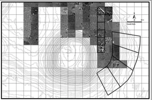
113
collecting involved full coverage of 7 squares of 20x20 m. and 4 sectors on the low slope (Fig. 5). On the top of the terrace and the low northern slope, within the 20x20 m squares used for the geomagnetic investigations, sixteen 5x5 m. units (units 1-112) and four radial sectors (lots 1-4) in five irregularly shaped bands11 were laid in order to fit the collecting grid to the morphology of theslope (units 113-132). The entire intensively surveyed area was 14060m2 (2800
m2 on the terrace and 11260m2 on the slope) equalling roughly 10% of the site.
In each of 132 surveyed units we collected all the artefacts from the surface (Fig. 6).12 Diagnostic artefacts and lithics were systematically collected for each
surveyed field unit as well as fragments of roof tiles and baked-bricks. Only the diagnostic artefacts were marked and mapped via total station.
b. Samples Analysis
Diagnostic and non-diagnostic artefacts were extensively collected and separated: within the diagnostic category the stone tools and the potsherds inclusive of rim, base, decoration, spout or handle have been sorted. Two different kinds of spreadsheets have therefore been created: the first is based on the specific location of the artefacts (diagnostic artefacts), determined by their catalogue number, and the second is based on the concentration of artefacts within the survey units (diagnostic and generic artefacts), determined by the percentage weight of the items and count. The corpus of materials collected consists mostly of sherds: 7,206 have been recovered for a total weight of 263 kg. In addition, 45 kg ca of tiles and 25 kg ca of scores have been collected (Tab. 1).
The distribution pattern of roof tiles (tegulae and imbrices) indicate that the Late Roman/Byzantine occupation might have been limited to the terrace and have consisted of ‘cappuccina’ burials.
11 The dimensions of these units (each lot is divided into five bands, coinciding with five collecting units) vary from 5x30 to 30x50 m. The first band of units, near the edge of the terrace, is narrower; the dimensions increase as one moves towards the valley floor. 12 The collection units were given individual names with the use of numbers and letters (20x20
m square labelled with letters and main units of the slope labelled as lot 1-5; 5x5 m square and single small units of the slope labelled with numbers).
114
Melted residuals from combustion, slags and a few ceramic wasters may be related to the presence of kilns; the many burnt bricks and architectural materials may, instead, indicate an apparently quite widespread destruction by fire. It is to be noted that their distribution is concentrated in the northern squares A-C of the terrace, in close connection with the irregular geomagnetic anomalies registered in that area.
As concerns pottery, 2,054 diagnostic and 5,152 generic potsherds were collected and recorded in distinct morphological and typological classes. Morphological classes (Common, Storage and Kitchen Wares) usually convey information on the spatial function of the surveyed areas; the technological category relates the method of manufacture and finishing, i.e. technology and modes of pottery production.
A total amount of 200 kg ca of Common Ware, 64 kg Storage Ware and 1kg of Kitchen Ware have been registered. While the pattern of distribution of Common Ware is quite homogeneous, Storage and Kitchen wares show distinct distributions. Storage Ware is, in fact, concentrated in the following areas: the north-eastern boarder of the terrace, in connection with the geomagnetic anomaly; in lot 2 on the eastern slope, in connection with another geomagnetic anomaly; in square D, in connection with roof-tiles, and in square C, in connection with slags. Kitchen Ware is concentrated on the terrace area in square G, in connection with Storage Ware, and over the squares A-B, in connection with a geomagnetic anomaly and burnt slags.
Eight classes have been identified: Plain Ware; Painted Ware; Grey Ware; Brown Ware; Red Slip Ware; Orange Slip Ware; Buff Fine ware and Whitish-yellow Slip Ware. Sherds seem to be all wheel-thrown, with a very few exceptions.
Plain Ware constitutes the major component of the assemblage of Kuşaklı Höyük. Finishing usually consists of simple smoothing, but ‘self-slips’ resulting from wet-smoothing are also well attested. The colours of the clay vary mainly between brown and orange nuances: brown and reddish brown colours seem to be the most diffused, but buff nuances are also attested.
115
Within the Plain Ware sample, standardized ‘drab’ ware, well fired and with uniform grit tempered fabric, can be easily recognized. The scraping marks made by trimming off the excess of clay after its removal from the wheel are clearly visible on the surface.A quite significant component of the Kuşaklı Höyük ceramic inventory is represented by different varieties of slipped wares. The most conspicuous is certainly the red-slipped ware. Several variants are, however, attested with regards to manufacture, finishing techniques and colours, indicating different traditions. The colour of the slip ranges from light red/pinkish red or reddish orange to purple red, reddish brown or reddish violet. The slip could be thick and homogeneously applied, probably by dipping, or very thin and unevenly applied, possibly by being wiped onto the surface of the vessel with a cloth or an instrument. The surface can be lustrous or mat. The slip is usually limited to the outer surface of the vessel or to its sole upper part, covering often a small portion of the inner rim. Among the variants we find fine tempered sherds with thick light-red/orange slip and deep smoothed surface; purple red/reddish brown and lustrous slip specimens; pinkish wiped slip sherds with chaff fabric; red edged vessels and red-slipped storage jars.
Other types to be mentioned are the orange-slipped sherds, both in fine or rough fabrics; brown ware sherds, with a well-smoothed or slightly burnished surface; common and rough fabrics with yellow or whitish slip and fine ware sherds with shining micaceous slip, probably to be identified with the Gold Wash Ware.
Painted Ware is documented by different types: common wares with simple red paint traces; bichrome painted ware in red and black colours; black painted ware and polychrome painted ware with white background and red and black colours. Furthermore, the hand-made painted ware, characterised by chaff and grits tempers and burnished surface, constitutes a distinct type.
116
c. Preliminary Remarks On The Ceramic Assemblage
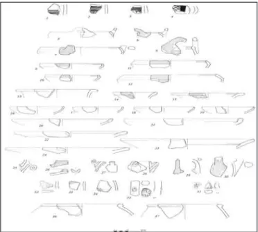
Materials from the area investigated furnish still preliminary information on the nature and chronology of the settlement. First of all, there is so far no evidence of the Early Bronze Age. The only documents of the earlier occupation of the site are represented by four hand-made and painted sherds (Fig. 7: 1-4) belonging the ‘Cappadocian Ware’ horizon, found at different points on the slope of the terrace.
Carinated red slipped bowls with V-shaped lugs (Fig. 7: 5-8) are generally markers of the karum and Old-Hittite period13, but continue to be used till the
end of Late Bronze Age.14 These types are concentrated mainly on the
north-eastern slope, in the central bands of lots 2-3.
The high carinated bowls with short vertical (Fig. 7: 9-10) or long incurved rim (Fig. 7: 11-12), usually red slipped on the outer edge or completely slipped, find comparisons in the Kuşaklı Höyük/Sarissa assemblage.15 The jars, in
common (Fig. 7: 13) and red slipped ware (Fig. 7: 14-15), concentrated on the eastern slope, might be dated to the Late Bronze Age, having comparisons in Kuşaklı Höyük/Sarissa; a similar typology of vessels and rims is documented also in the karum period and in the Iron Age. Spouts (Fig. 7: 25-26), vertical handles (Fig. 7: 29-30) and some portion of V-shaped lugs (Fig. 7: 31) belonging to jars and particular vessels have to be dated to the same range of time,16 although some examples could be earlier. Fragments of body sherds
(Fig. 7: 32-34) and handles (Fig.7: 35) with similar stamped signs on them are documented from the karum to the Hittite periods.17 We also found a sherd
bearing part of an impressed ‘signe royal’.
Jars and pithoi (Fig. 8: 40-41), in common and red slipped wares, cannot be
13 Mielke D.P., Die Keramik vom Westhang, (Kuşaklı-Sarissa, band 2), Verlag Marie Leidorf GmbH, Rahden/Westf. 2006: 149, 123.
14 At Kaman-Kalehöyük for example (Matsumura, K., Die Eisenzeitliche keramik in Zentralanatolien
aufgrund der Grundlage der Ausgrabung von Kaman-Kalehöyük, Ph.D. diss, Berlin 2005: 305.
KL96-M51).
15 Mielke 2006, op. cit.: taf. 57.44, 58.1, 56.5. 16 Mielke 2006, op. cit.46-47, taf. 1.2.
17 Seidl U., Gefässmarken von Boğazköy, (Boğazköy- Hattuša: Ergebnisse der Ausgrabungen VIII), Gebr. Mann Verlag, Berlin 1972: A50 and A26.
117
dated with certainty. In some cases, the use of both red slip and white/buff slip on the rim or below it offers comparisons with Kuşaklı Höyük/Sarissa and Böğazköy.18Bowls in Drab Ware, generally buff to brown in colour, offer good comparison with the main Hittite assemblages. Plain medium and small-sized bowls with simple and often pointed rim (Fig. 7: 16-19), a large flat bowl with a thickened rim (Fig. 7: 20-21) and coarse plates (Fig. 7: 22-23) have to be dated to the Hittite period, on the basis of the Boğazköy sequence and building C of Kuşaklı Höyük. 19 Cooking pots (Fig. 7: 36-37) have globular body and folded
rim. This shape too fits well in the assemblages dating to the same period. Iron Age sherds are quite scattered. A few painted sherds with black colour (Alişar IV type) (Fig. 8: 45-47) date to the Middle/Late Iron Age. There are sherds with a white background and red and black colours (Polychrome Ware) and probably an example of Bichrome Ware decorated with a band and concentric circles (Fig. 8: 48). Necked jars in Simple (Fig. 8: 42-43) or Red Slipped Ware (Fig. 8: 44) and craters with black painted motifs (Fig. 8: 50-51) are typical of this period and find comparisons in the Phrygian levels of Böğazköy20, Alişar Höyük 21 and Kaman-Kalehöyük.22
18 Mielke 2006, op. cit. : 142; Müller-Karpe A., Hethitische Töpferei der Oberstadt von Hattuša: ein
Beitrag zur Kenntnis spät-grossreichszeitlicher Keramik und Töpferbetriebe unter Zugrundelegung der Grabungsergebnisse von 1978-82 in Boğazköy, (Marburger Studien zur Vor- und Frühgeschichte,
band 10), Hitzeroth Verlag, Marburg/Lahn 1988: 146, taf. 48.
19 Parzinger H. and Sanz R., Die Oberstadt von Hattuša: hethitische Keramik aus dem zentralen
Tempelviertel. Funde aus den Ausgrabungen 1982-1987, (Boğazköy- Hattuša: Ergebnisse der
Ausgrabungen XV), Gebr. Mann Verlag, Berlin 1992: tav. 26.19-27, 38.1-6; Mielke, op. cit.: 128-134; taf. 57, 55; Schoop U.D., ‘Pottery Tradition of the Late Hittite Empire: Problems of Definition’ in B. Fischer, H. Genz, É. Jean, K. Köroğlu (eds.), Identifying Changes: the Transition
from Bronze to Iron Ages in Anatolia and its Neighbouring Regions, Proceedings of the International Workshop Istanbul, November 8-9,2002, Türk Eskiçağ Bilimleri Enstitüsü, Istanbul 2003: 173;
‘Dating the Hittites with Statistics: Ten Pottery Assemblages from Boğazköy- Hattuša’, in D.P. Mielke, U.-D. Schoop, J. Seeher (eds.), Strukturierung und Datierung in der hethitischen
Archäologie (BYZAS 4), Ege Yayınları, Istanbul 2006: 215-239.
20 Bossert E.-M., Die Keramik phrygischer Zeit von Boğazköy: Funde aus den Grabungskampagne 1906,
1907, 1911, 1921, 1931-1939 und 1952-1960, Boğazköy- Hattuša: Ergebnisse der Ausgrabungen
XVIII), Verlag Philipp von Zabern, Mainz am Rhein 2000: farbtafel E: 272, 291; taf. 6, 9, 11, 15, 18, 22, 117-120, 123, 133.
21 von der Osten H.H., The Alishar Höyük: Seasons of 1930-32, Part II, (Oriental Institute Publications XXIX), University of Chicago Press, Chicago1937: fig. 445-471.
118
d. Preliminary Remarks On The Pottery Distribution
The connection between the pottery attributed to the 2nd millennium and architecture identified by the geomagnetic survey can hardly be considered fortuitous. In particular, the density of Drab Ware sherds over a limited area of the northern and eastern slopes (collecting units F-G; and lot 2, bands 2, 4; lot 3, bands 2-3; lot 4: bands 1-2), may suggest, in a preliminary manner, that the buildings appearing in this area might belong to the Late Bronze Age. Red slipped ceramic sherds were found fairly evenly across the entire mound with a major density on the eastern slopes of the terrace (lots 2, band 2, 3; lots 3, bands 1, 2, 4; lot 4, bands 1-2), where a fair number of diagnostic sherds dating to the karum period are present.
To conclude, the geomagnetic survey and the analysis of the materials, albeit preliminary, seem to indicate that the settlement was characterized by a steady continuity of occupation from the end of the Early Bronze Age to the Byzantine period with a major phase of occupation in the course of the 2nd
millennium.
4. Investigations of the Kuşaklı Höyük Archaeological Landscape.
The survey was conducted in a very limited area in the vicinity of Kuşaklı Höyük, aiming to define the nature and development of its territory over a lengthy duration. The region is dominated by granitic cliffs and mountains, rich in springs and water, specially to the south of the river Egri Öz Dere, which flows from WNW to E., and to the south of the highway linking the modern towns of Yozgat and Sorgun. Kuşaklı Höyük is located in the southern and western part of a quite large plain limited on the N by the Egri Öz Dere. The höyük lays on the southern bank of the river in a large recess shaped by the meandering course of the river here. The plain is limited to the N by gentle hills while it is dominated far away to the S by the high profile of the Kerkenes Dağ. Its SW borders are defined by high cliffs and mountains with springs and deep gorges where the Kötü Dere, a SW tributary of the Egri
119
Öz Dere, flows. The quite steep flanks of the mountains are here marked by natural caves and small terraces. On their flank, 2 km. S. of Kuşaklı Höyük, between the villages of Taşlık Büyük and Taşlık Küçük, the Kerkenes survey23was able to identify a small höyük on the top of a natural spur of the rock. On its surface we collected a discrete number of sherds dating to the Late Chalcolithic and Early Bronze Age; these consist of hand-made bowls and jars and a fragment of andiron. The surface colours are black, red and buff in different variants. Chaff and grits tempers with few lime inclusions are the most typical; burnishing of outer and inner surfaces is fairly common. A few sherds belong to bowls of the final Iron Age/Achaemenid period.
A visit to the village of Aşağı Karakaya Köy, to the N. of the river, had the aim of verifying the Hittite block and its provenience. The slab and a few other architectural features are currently preserved in the garden of the Mosque and are said to come from the older Mosque and cemetery of the village. No other element, however, is preserved in the village. A large valley to the N, characterized by granitic outcrops lying on the higher flanks of the hills and low mountains, gives no evidence of settlements with dispersion of sherds ; a few late Byzantine materials were recognized only in the major granitic outcrop to the NE of the village.
The area adjacent to the village on the E is also characterized by gentle hills; near the highway, SW of the village of Dişli, a hill is topped by different tumuli excavated in recent times by clandestine robbers; burnished orange ware sherds might indicate a late Iron date. There is no dispersion of materials and consequently no traces of settlement are evident on the surface.
A second goal of the regional survey is to understand the communication routes linking the region with the Hittite capital, Hattusha. Small transversal NS and EW valleys among the relatively low cliffs to the N of Kuşaklı might have provided easy routes, and small rivers were also a consistent pattern of the landscape, defining a major network of connections among the valleys. While the high and distinct profile of Kerkenes Dağ marks the southern
120
horizon of the landscape, no clearly defined features mark the NE horizon. The NW landscape is, instead, patterned by a variety of geographical marks, such as the mountains bordering Hattusha and small rivers providing water resources as well as clear route alignments along the bottom of the valleys.
Conclusive Remarks
The 2008 survey, albeit preliminary, was able to furnish clear evidence for the identification of Kuşaklı Höyük as a Hittite site that was also occupied in the Late Iron and Byzantine periods. In the course of the 2nd millennium B.C. the site reached the dimensions of the present-day höyük covering 10 ha.; it was a town of medium size with three outer gates in the lower town/terrace, one of which was built with large blocks. Buildings of a regular plan registered by the geomagnetic analysis seem to belong to the central phase of occupation of the site. The presence of burnt bricks and materials, even vitrified by high temperatures, on the surface of the lowest slope of the mound and on the inner side of the terrace, provides evidence of an overall destruction phase. In many places there are conspicuous traces of burnt bricks, vitrified slags and ashes indicating that a there was a large fire in this part of the settlement. This destruction might have been a major event affecting the whole site and it was probably this that put an end to the main phase of the settlement. No material of the Early Iron Age is evident on the surface of the terrace, thus, on the basis of these preliminary finding, we must assume that there was a major gap in the sequence of this part of the site.
Concerning the question of the identification with Zippalanda, the data furnished by the pottery, the nature, characteristics and main occupation phase of the site do not disagree with this hypothesis. No other site of similar size and with such a rich 2nd millennium pottery assemblage can be recognized in the region. Kuşaklı Höyük stands as the main Hittite settlement along the Yozgat-Sorgun line and it probably owed its emergence and later development to its position on the plain, near the river and the passage linking the northern high plateau of Hattusha with its southern boundaries.
121
Survey Unit Tiles (Kg) Scores (Kg) Sherds totality (Kg) ware (Kg)Common ware (Kg)Storage ware (Kg)Kitchen
1 0,73% 0,17% 0,23% 2 5,25% 0,12% 0,16% 3 0,40% 0,11% 0,14% 0,96% 4 0,57% 0,15% 0,20% 5 0,81% 0,09% 0,13% 6 0,73% 0,08% 0,11% 7 0,49% 0,19% 0,25% 8 0,08% 0,06% 0,08% 9 3,64% 0,08% 0,11% 10 4,04% 0,30% 0,40% 11 2,34% 0,25% 0,27% 11,54% 12 1,21% 0,14% 0,19% 13 4,85% 0,14% 0,16% 4,81% 14 1,46% 0,17% 0,22% 15 0,66% 0,49% 0,19% 0,25% 16 0,49% 0,22% 0,29% 17-32 6,39% 15,97% 2,64% 2,42% 3,32% 3,85% 33 0,97% 0,27% 0,30% 0,19% 34 0,42% 2,83% 0,26% 0,24% 0,32% 35 0,08% 0,27% 0,31% 0,16% 36 1,82% 0,20% 0,25% 0,06% 37 0,49% 0,16% 0,15% 0,19% 38 2,59% 0,15% 0,11% 0,28% 39 1,46% 0,15% 0,20% 40 2,02% 0,14% 0,16% 0,06% 41 0,16% 0,11% 0,14% 42 1,10% 1,62% 0,19% 0,25% 43 0,81% 0,31% 0,36% 0,16% 44 0,44% 4,45% 0,36% 0,03% 1,42% 45 0,44% 0,00% 0,08% 0,11% 46 3,23% 0,13% 0,17% 47 1,54% 0,11% 0,15% 48 1,82% 0,11% 0,15% 49 2,33% 0,00% 0,11% 0,09% 0,19% 50 1,21% 1,21% 0,21% 0,15% 0,41% 51 0,73% 0,26% 0,35% 52 0,37% 0,49% 53 1,76% 0,40% 0,08% 0,10% 54 3,13% 0,32% 0,11% 0,12% 0,09% 55 0,01% 3,23% 0,07% 0,09% 56 0,11% 0,14% 57 4,49% 0,97% 0,13% 0,15% 0,08% 58 1,19% 0,15% 0,08% 0,38% 59 0,88% 0,17% 0,23%
122
Survey Unit Tiles (Kg) Scores (Kg) Sherds totality (Kg) ware (Kg)Common ware (Kg)Storage ware (Kg)Kitchen
60 0,11% 0,15% 0,20% 61 7,09% 0,28% 0,38% 62 1,13% 0,52% 0,30% 1,23% 63 3,79% 0,32% 0,35% 0,46% 64 0,44% 0,34% 0,33% 0,41% 65 0,44% 1,21% 0,25% 0,33% 66 3,08% 0,33% 0,44% 67 4,41% 0,81% 0,24% 0,32% 68 4,04% 0,27% 0,25% 0,32% 69 0,22% 0,16% 0,21% 70 8,15% 0,05% 0,07% 71 0,66% 4,85% 0,27% 0,35% 72 5,07% 0,64% 0,85% 73 1,98% 0,36% 0,48% 74 2,53% 0,18% 0,24% 75 0,22% 0,20% 0,26% 76 0,48% 0,16% 0,21% 77 2,64% 0,21% 0,28% 78 1,43% 0,49% 0,41% 0,55% 79 1,59% 0,64% 0,85% 80 1,37% 0,26% 0,34% 81 0,35% 0,15% 0,13% 0,22% 82 0,18% 0,24% 83 0,42% 0,34% 0,70% 84 0,88% 0,20% 0,26% 85 0,09% 0,12% 86 0,20% 0,21% 0,19% 87 0,22% 0,29% 88 0,73% 0,31% 0,42% 89 0,17% 0,17% 0,19% 90 0,26% 0,34% 91 0,24% 0,21% 0,35% 92 0,66% 0,61% 0,81% 93 0,24% 0,28% 0,13% 94 0,22% 0,29% 95 0,44% 0,58% 96 0,64% 0,57% 0,87% 97 0,60% 0,80% 98 0,20% 0,26% 1,92% 99 0,84% 0,28% 0,27% 0,16% 9,62% 100 0,02% 0,37% 0,49% 101 0,41% 0,54% 102 0,44% 0,46% 0,45% 0,51% 103 0,26% 0,23% 0,21% 0,32%
123
Survey Unit Tiles (Kg) Scores (Kg) Sherds totality (Kg) ware (Kg)Common ware (Kg)Storage ware (Kg)Kitchen
104 0,27% 0,36% 105 0,62% 0,79% 0,90% 0,44% 106 0,78% 0,62% 1,30% 107 0,53% 0,56% 0,41% 0,96% 108 0,32% 0,60% 0,24% 1,58% 9,62% 109 0,16% 0,96% 1,05% 0,70% 110 0,39% 0,52% 111 0,36% 0,48% 112 0,40% 0,53% 113 0,44% 1,22% 1,11% 1,58% 114 4,63% 2,54% 2,35% 3,16% 115 1,10% 3,48% 2,80% 5,69% 116 4,07% 6,06% 1,63% 1,50% 2,06% 117 1,87% 1,29% 1,95% 1,43% 3,64% 118 1,10% 5,30% 1,47% 17,48% 119 5,52% 5,80% 4,74% 120 8,34% 8,23% 8,86% 121 0,45% 3,86% 4,21% 2,82% 122 0,53% 3,80% 4,36% 2,10% 123 3,08% 0,81% 1,56% 1,11% 3,00% 124 1,37% 0,73% 4,69% 4,76% 4,27% 16,35% 125 0,66% 7,05% 7,91% 4,43% 126 0,79% 3,85% 4,23% 2,53% 12,50% 127 0,44% 1,28% 1,48% 0,66% 128 0,23% 0,31% 129 1,63% 0,73% 5,25% 5,78% 3,35% 19,23% 130 1,94% 6,61% 5,38% 10,50% 7,69% 131 0,48% 1,97% 2,19% 1,30% 0,96% 132 1,10% 1,43% 1,74% 0,49% TOT 100% = 100% = 100% = 100% = 100% = 100% = tot 45,40 Kg 24,74 Kg 264 Kg 199,73 Kg 63,23 Kg 1,04 Kg Tab. 1
124
Fig. 1: Kuşaklı Höyük (from North)
125
Fig. 3: Plan and topographic grid
126
Fig. 5: Kuşaklı Höyük: topographic grid with locations of surveyed units
127
Fig. 7: Cappadocian Ware (n. 1-4) and 2nd millennium ceramics (n. 5-37) from Kuşaklı Höyük
Fig. 8: Late 2nd millennium ceramics (n. 38-41) and Iron Age ceramics (n. 42-51) from Kuşaklı Höyük. Late Chalcolithic and Early Bronze Age ceramics (n. 52-58) from Taşlık Höyük