CAHIERS DE L'ASSOCIATION INTERNATIONALE DU DROIT DE LA MER PAPERS OF THE INTERNATIONAL ASSOCIATION OF THE LAW OF THE SEA
G
OVERNANCE OF THE
A
DRIATIC AND
I
ONIAN
M
ARINE
S
PACE
Edited by
A
NDREA
C
ALIGIURI
EDITORIALE SCIENTIFICA 2016
PROPRIETÀ LETTERARIA RISERVATA
© Copyright 2016 Editoriale Scientifica s.r.l. Via San Biagio dei Librai, 39 – 80138 Napoli
www.editorialescientifica.com – [email protected]
Preface ... XIII
Acknowledgments ... XV
Abbreviations ... XVII
INTRODUCTION
The Maritime Boundaries in the Adriatic and Ionian Seas
ANDREA CALIGIURI ... 3
PART 1
THE ADRIATIC-IONIAN SPACE FROM THE VENETIAN DOMINATION TO THE EUROPEAN INTEGRATION MODEL
The Adriatic-Ionian Space from the Domination of Venice to the Birth of Nations
GIOVANNI BRANCACCIO ... 19
The Republic of Venice: Commercial Autonomy and Law Politics as an Identity-Making Space
NINFA CONTIGIANI ... 31
The Ordinamenta and Statuta Maris of Trani and “Mediterranean Common Law”
FRANCESCO MASTROBERTI ... 41
The Geopolitics of the Adriatic-Ionian Macro-Region
ROBERTO BELLONI ... 57
The Role of European Macro-Regions in the Governance of the Seas. Baltic and Adriatic: Comparing Two Models
PIETRO GARGIULO ... 59
PART 2
THE LEGAL REGIME OF THE ADRIATIC AND IONIAN SEAS
The Legal Regime of the Semi-enclosed Seas in the light of the UNCLOS and the EU Role in the Governance of Adriatic and Ionian Marine Space
Maritime Spatial Planning and Integrated Coastal Zone Management in Adriatic and Ionian Region: EU Approach
MAURA MARCHEGIANI ... 89
The Adriatic-Ionian Marine Region as a Space of Connectivity: Transport and Protection of the Marine Environment
MITJA GRBEC ... 97
Reconsidering the Marine Scientific Research in the Adriatic and the Ionian Seas: Taking Stock and Looking ahead
EMMANUELLA DOUSSIS ... 107
The 2001 UNESCO Convention and Protection of Underwater Cultural Heritage in the Adriatic and Ionian Seas
TRPIMIR M.ŠOŠIĆ ... 119
PART 3
THE GOVERNANCE OF BIOLOGICAL RESOURCES
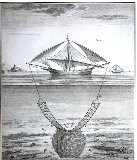
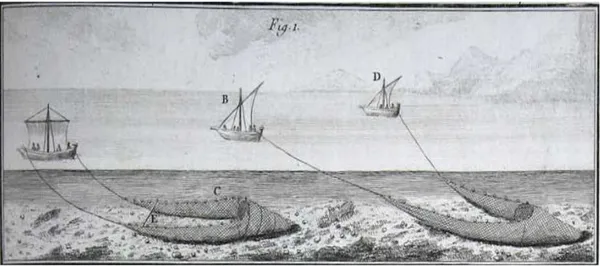
Fishing in the Adriatic: From Technical Innovation to Resource Preservation. A Historical Overview
MARIA CIOTTI ... 139
The Sustainability of Fishing in the Southern Adriatic and Northern Ionian Seas
ROBERTO CARLUCCI,PORZIA MAIORANO,LETIZIA SION,
GIANFRANCO D’ONGHIA,ANGELO TURSI ... 149
Organizational and Strategic Profiles of Marine Protected Areas: Some Case Studies in the Adriatic and Ionian Region
CLAUDIA SCIANNA,FEDERICO NICCOLINI,PAOLO GUIDETTI ... 161
New Challenges for the Marine Science: The Biological Resource Exploitation
ANTONELLA PENNA ... 169
PART 4
THE OFFSHORE OIL AND GAS EXPLORATION AND EXPLOITATION
The Old and the New Policies and Politics of Offshore Hydrocarbon Development in the Adriatic and Ionian Seas
ANDREA PRONTERA ... 177
The Powers of Coastal States over Offshore Oil Platforms
Environmental Challenges of Offshore Activities in International and European Union Law
NATHALIE ROS ... 203
Liability and Compensation for Damage Caused in Connection with Offshore Oil and Gas Activities: A Work in Progress
LORENZO SCHIANO DI PEPE ………...……….. 221
Possible Oil Pollution in the Adriatic Sea
MIRA MOROVIĆ,ANDREI IVANOV,MARINKO OLUIĆ,ŽARKO KOVAČ,
NADEZDA TERLEEVA ... 233
GEMMA ANDREONE –Centro Nazionale delle Ricerche
ROBERTO BELLONI – Università degli Studi di Trento
GIOVANNI BRANCACCIO –Università degli Studi “G. D’Annunzio” Chieti-Pescara
ANDREA CALIGIURI – Università degli Studi di Macerata
ROBERTO CARLUCCI –Università degli Studi di Bari “A. Moro”
MARIA CIOTTI –Università degli Studi di Macerata
NINFA CONTIGIANI –Università degli Studi di Macerata
GIANFRANCO D’ONGHIA –Università degli Studi di Bari “A. Moro”
EMMANUELLA DOUSSIS –National and Kapodistrian University of Athens
PIETRO GARGIULO – Università degli Studi di Teramo MITJA GRBEC – Maritime Law Association of Slovenia
PAOLO GUIDETTI – Université Nice Sophia Antipolis
ANDREI IVANOV –P.P. Shirshov Institute of Оceanology, Russian Academy of Sciences
ŽARKO KOVAČ –Institute of Oceanography and Fisheries, Croatia
PORZIA MAIORANO –Università degli Studi di Bari “A. Moro”
MAURA MARCHEGIANI – Università per Stranieri di Perugia
FRANCESCO MASTROBERTI –Università degli Studi di Bari “A. Moro”
MIRA MOROVIĆ– Institute of Oceanography and Fisheries, Croatia
FEDERICO NICCOLINI – Università degli Studi di Pisa MARINKO OLUIĆ –GEO-SAT, Croatia
ANDREA PRONTERA – Università degli Studi di Macerata NATHALIE ROS – Université François Rabelais de Tours LORENZO SCHIANO DI PEPE –Università degli Studi di Genova
CLAUDIA SCIANNA – Université Nice Sophia Antipolis LETIZIA SION –Università degli Studi di Bari “A. Moro”
TRPIMIR M.ŠOŠIĆ – University of Zagreb IOANNIS STRIBIS – University of the Aegean
NADEZDA TERLEEVA – P.P. Shirshov Institute of Оceanology, Russian Academy of
Sciences
SCIENTIFIC COMMITTEE
SERGIO M.CARBONE Full professor of International Law
University of Genoa, Italy PAOLO PALCHETTI Full Professor of International Law
University of Macerata, Italy MAJA SERSIC
Full Professor of International Law University of Zagreb, Croatia
HARETINI DIPLA
Full Professor of International Law National and Kapodistrian University of Athens
ŽELJKO RADIĆ
Associate Professor of Legal History University of Split
MILOŠ VEC
Professor of European Legal and Constitutional History Vienna University
At the dawn of the third millennium governance of the seas and oceans is changing. This is especially attributable to the growing role of regional economic integration organizations. The EU, with its integrated maritime policy, the African Union, through its “Integrated African Strategy for the Seas and the Oceans – Horizon 2050”, ASEAN, through the creation of the Maritime Forum, are the principal examples of the current tendencies on this issue.
The International Association of the Law of the Sea (AssIDMer) has been focusing on this particular topic for some time. The Proceedings of the fifth ordinary meeting of the Association, held in Venice on 20 and 21 November 2014, have just been published, under the title: “International Law and Maritime Governance. Current Issues and Challenges for Regional Economic Integration Organizations” (A. Del Vecchio, F. Marrella (eds), Editoriale Scientifica, 2016). The authors of this book place special focus on the impact that regional economic integration organizations have on the exploitation of natural resources, the relationship between human rights and the law of the sea and on what is known as the “Blue Economy”.
These issues were raised once again in this Volume in a context that is much more limited from the geographic perspective, that of the Adriatic and the Ionian Region, but extremely thorough from the scientific viewpoint. Indeed, the analysis is not limited simply to the economic and juridical aspects but also deeply covers historical backgrounds, as well as Governance of Biological Resources and Offshore Oil and Gas Exploration and Exploitation.
It is no coincidence that Art. 123 UNCLOS envisages a “reinforced” duty of cooperation for coastal States bordering enclosed and semi-enclosed seas. The characteristic of the Mediterranean (the largest of the seas that may be defined as “semi-enclosed” according to Art. 122 UNCLOS) is that it also comprises within itself marine spaces that are also considered as enclosed or semi-enclosed, and that consequently have aspects of greater “sensitivity” compared to the rest of the Mediterranean. The Adriatic and the Ionian seas are among them and are to be considered as “semi-enclosed seas in a semi-enclosed sea”. The Adriatic especially as it links together the territory of seven States: Italy, Slovenia, Croatia and Greece, member States of the EU; two nations that are candidate States, Montenegro and Albania; and a potential candidate, Bosnia-Herzegovina, with a part of its territorial sea surrounded by the waters of Croatia.
The absence of cooperation among the coastal States of the Mediterranean, which has led to unilateral initiatives extending coastal jurisdiction, certainly has not spared the Adriatic and the Ionian. The more limited the extension of water compared to the number of States bordering the basin, the more difficult is cooperation and the more complex are questions of delimitation of marine spaces. Maritime borders are therefore particularly fragile as it is difficult for a delimitation made bilaterally to escape challenges from third States that are, by necessity, located close to the delimited zone. Added to this are the technical difficulties caused by the presence of islands and islets and the conformation of generally highly indented coastlines. Even more problematic are the unilateral initiatives to extend jurisdiction in this marine space, a crucial factor given the need for close cooperation among coastal States. The Adriatic, a good part of which consists of high seas, has furthermore been constantly the subject of exploitation of its fishing resources by non Adriatic and non Mediterranean ships, often equipped for
industrial fishing. The absence of control and of enforceable measures to manage resources has fueled Illegal, Unregulated and Unreported (IUU) fishing. In addition, we have recently witnessed, in both the Adriatic and the Ionian, an acceleration of exploration activities and exploitation of off shore hydrocarbon and gas deposits, especially in light of the ongoing political crisis between Russia and the Ukraine, with consequent repercussions throughout Europe. These activities also require new regulations and especially greater cooperation among the States involved. As has happened in the past concerning the exploitation of fishing and environmental governance, in this area also coastal States proceeded unilaterally, using national laws and regulations and granting rights of exploration, exploitation and construction of offshore platforms. Several countries, such as Croatia, have initiated this “tendency”, while others, Italy for one, have adopted a “wait and see” approach, deciding to act only when it became inevitable in light of decisions made by other countries. Recent developments point to a rethinking concerning these decisions. It is clear that there exists an immediate issue of the sustainability, by a fragile ecosystem such as the Adriatic and the Ionian (and in more general terms perhaps the Mediterranean itself), of the activities currently being carried out and especially those anticipated over the next few years in order to access new energy sources.
These concerns are part of a more general framework of management of the environment in enclosed and semi-enclosed seas. The Adriatic is already suffering from anthropic activities, it requires a century for the complete exchange of its waters. How can we possibly ignore the impact that an incident as serious as what happened in the Gulf of Mexico in 2010 would have in such a circumscribed space!
The problem is that the legal instruments in effect, on an international level and within the European Union, at times seem inadequate and obsolete. The general legal framework of reference doubtless remains the UNCLOS, ratified by all States bordering on this sea, but this Charter has now been in effect for more than twenty years and was originally drafted over thirty years ago, with many of its provisions applying to ocean spaces. Many other “regional” or “sub-regional” agreements regarding protection of the marine environment were later ratified by Adriatic States. Of these regional agreements we take particular note of the 1995 Barcelona Convention on protecting the Mediterranean from pollution, and its Protocols providing the general principles and institutional framework for protection of the marine environment. Recourse to the general principles of precaution, prevention and environmental sustainability nonetheless remain a constant, proof of the lack of any truly effective and comprehensive international laws.
All these issues are thoroughly analyzed in this volume. A sincere thanks to the editor and to the individual authors for their contributions and for the completeness of information as well as the stimuli they provide to the progress and development of the scientific debate on governance of the seas in general and the Adriatic and Ionian Region in particular.
GIUSEPPE CATALDI President, International Association of the Law of the Sea
This Volume collects final results of the Research Project “Marine Resources
Management Plan for the Adriatic and Ionian Region – MaReMaP-AIR”, funded by the
Università di Macerata.
I would like to express my deep gratitude to all the member of the research group of this Project for skillfully helping to analyze the main aspects of the multilevel governance system of the Adriatic and Ionian seas: Gemma Andreone (Istituto di Studi Giuridici Internazionali – CNR, Italy), Chiara Biscarini (Università per Stranieri di Perugia, Italy), Maria Ciotti (Università di Macerata, Italy), Ninfa Contigiani (Università di Macerata, Italy), Giulia D’Agnone (Università di Roma “Unitelma Sapienza” , Italy), Maura Marchegiani (Università per Stranieri di Perugia), Fernando Nardi (Università per Stranieri di Perugia, Italy), Michele Scardi (Università di Roma Tor Vergata, Italy), Lorenzo Schiano di Pepe (Università di Genova, Italy), Andrea Prontera (Università di Macerata, Italy), Nathalie Ros (Université François Rabelais de Tours, France), Eva M. Vásquez Gómez (Universidad de Córdoba, Spain).
Finally, I am grateful to the partners of the Project: Adriatic and Ionian Initiative (AII), Association Internationale du Droit de la Mer (AssIDMer), Augeo S.r.l. and ECON S.r.l.
I trust this Volume will be a valuable contribution to the ongoing debate on the implementation of the European Union Strategy for the Adriatic and Ionian Region (EUSAIR).
AII Adriatic and Ionian Initiative
CIESM Commission for the Scientific Exploration of the Mediterranean Sea
CMI Comité Maritime International
CPUCH Convention on the Protection of the Underwater Cultural Heritage
EEA European Economic Area
EEZ Exclusive Economic Zone
EFPZ Ecological and Fisheries Protection Zone
EPZ Ecological Protection Zone
ESA European Space Agency
EU European Union
EUSAIR European Union Strategy for the Adriatic and Ionian Region
EUSALP European Union Strategy for the Alpine Region
EUSBSR European Union Strategy for the Baltic Sea Region
EUSDR European Union Strategy for the Danube Region
FAO Food and Agriculture Organization
GES Good Environmental Status
GFCM General Fisheries Commission for the Mediterranean
ICJ International Court of Justice
ICZM Integrated Coastal Zone Management
ITLOS International Tribunal of the Law of the Sea
IHO International Hydrographic Organization
IMO International Maritime Organization
IDI Institut de Droit International
MARPOL International Convention for the Prevention of Pollution from Ships
MPA Marine Protected Area
MSP Maritime Spatial Planning
NGOs Non-Governmental Organizations
PSSA Particularly Sensitive Sea Area
REMPEC Regional Marine Pollution Emergency Response Centre for the Mediterranean Sea
SFRY Socialist Federal Republic of Yugoslavia
TAP Trans-Adriatic Pipeline
TEU Treaty on the European Union
TFEU Treaty on the Functioning of the European Union
UNCLOS United Nations Convention on the Law of the Sea
UNEP United Nations Environment Programme
SUMMARY: 1. Geographic delimitation of the Adriatic and Ionian seas. – 2. Maritime delimitation in a semi-enclosed sea. – 2.1. Maritime delimitations between former Yugoslav States. – 2.2. Maritime Delimitation between Montenegro and Albania. – 2.3. Maritime Delimitation between Albania and Greece. – 3. Delimitation of sui generis maritime zones. – 4. Maritime disputes and governance of offshore shared natural resources.
1. Geographic delimitation of the Adriatic and Ionian seas
The Adriatic Sea forms a long but relatively narrow gulf, generally aligned from northwest to southeast, toward its only access, the Strait of Otranto. The International Hydrographic Organization (IHO) defines the boundary of the Adriatic sea on the South as a line running from the Butrinto River's mouth (39°44'N) in Albania to the Karagol Cape in Corfu, through this island to the Kephali Cape (these two capes are in latitude 39°45'N), and on to the Santa Maria di Leuca Cape (39°48'N).1
The Adriatic Sea connects the territories of seven States: Italy, Slovenia, Croatia, Bosnia and Herzegovina, Montenegro, Albania and Greece. The Adriatic Sea is undoubtedly a semi-enclosed sea under Article 122 UNCLOS.2
The IHO defines the limits of the Ionian Sea as follows: on the North, a line running from the mouth of the Butrinto River (39°44'N) in Albania, to Cape Karagol in Corfu (39°45'N), along the North Coast of Corfu to Cape Kephali (39°45'N) and from thence to Cape Santa Maria di Leuca in Italy; on the East, from the mouth of the Butrinto River in Albania down the coast of the mainland to Cape Matapan; on the South, a line from Cape Matapan to Cape Passero, the Southern point of Sicily; and on the West, the East coast of Sicily and the Southeast coast of Italy to Cape Santa Maria di Leuca”.3
The Ionian Sea connects the territories of three States: Italy, Greece, and Albania. Under Article 122 UNCLOS, the Ionian Sea could also be regarded as a semi-enclosed sea when its coastal States – Albania, Greece and Italy – will proclaim their exclusive economic zones; indeed, a semi-enclosed sea may consist “entirely or primarily” of the territorial seas and exclusive economic zones of two or more States.
2. Maritime delimitation in a semi-enclosed sea
Six coastal States of Adriatic and Ionian seas claim 12 nm breadth of territorial seas, which is consistent with UNCLOS. Bosnia and Herzegovina exercises its sovereignty
1
See IHO, Limits of Oceans and Seas (Special Publication No. 28), 3rd Ed., 1953, 17. On the limits of the Adriatic Sea accepted by the International Maritime Organization (IMO), see in this Volume, M. Grbec, ‘The Adriatic-Ionian Marine Region as a Space of Connectivity: Transport and Protection of the Marine Environment’, para 1. For information about physical characteristics of the Adriatic Sea, see B. Cushman-Roisin, M. Gacic, P.-M. Poulain, A. Artegiani (eds), Physical Oceanography of the Adriatic Sea. Past, Present and Future (Springer, 2001).
2
Under Article 122 UNCLOS, “enclosed or semi-enclosed sea” means “a gulf, basin or sea surrounded by two or more States and connected to another sea or the ocean by a narrow outlet or consisting entirely or primarily of the territorial seas and exclusive economic zones of two or more coastal States”.
3
over the waters of the Bay of Neum and around Klek peninsula, enclosed within the Croatian system of straight baselines.4
Two treaties define the delimitation of territorial sea5 and continental shelf6 boundaries between Italy and the former SFRY. The delimitation was mostly based on the median line between the basic lines from which the territorial sea of former SFRY and Italy was measured. The delimitation line was 353 nm long, joining 43 points. The maritime delimitation line between Italy and former SFRY has been inherited by the post-Yugoslavia successor States; thus, sections of the Italy-Yugoslavia maritime boundary line now exist as boundaries between Italy and Slovenia, Italy and Croatia7 and Italy and Montenegro.
Greece and Italy concluded a continental shelf delimitation agreement in 1977.8 A continental shelf delimitation agreement was also concluded between Italy and Albania in 1992 which extends southwards of the Strait of Otranto and into the Mediterranean Sea.9 However, maritime delimitation in the Eastern Adriatic, among the former Yugoslav Republics, between Albania and Montenegro and between Albania and Greece still remains a largely unresolved issue.
All these disputes should be solved according to UNCLOS’ general rules concerning delimitation between States with adjacent coasts.10 In particular, it must be emphasized that the law of the sea does not recognize special rules on the delimitation of marine spaces in enclosed or semi-enclosed seas. Recently, in a dispute with Ukraine over the maritime delimitation in the Black Sea, before the International Court of Justice (ICJ), Romania had suggested that “the enclosed nature of the Black Sea is also a relevant circumstance as part of the wider requirement to take account of the geographical
4
Maritime boundaries between Croatia and Bosnia and Herzegovina are established in the Treaty on State Frontier of 30 July 1999 (this Treaty is not ratified by Croatia, but it has been provisionally applied since the day of its signature). Article 4(3) states: “The state border on the sea stretches along the central line of the sea between the territories of the Republic of Croatia and Bosnia and Herzegovina in accordance with the 1982 UN Convention on Sea Rights. […]”. Although the legal regime of the waters in the Bay of Neum and around the Klek peninsula has not been defined in the Treaty, it is reasonable to assert that the waters inside the Bay of Neum are “internal waters” and waters around the Klek peninsula are territorial waters of the Bosnia and Herzegovina (see B. Vukas, ‘Maritime Delimitation in a Semi-enclosed Sea: The Case of the Adriatic Sea’ in R. Lagoni, D. Vignes (eds), Maritime Delimitation, Leiden / Boston, 2006, 205 ff., 215). It should also be noted that the enclosure of the maritime area of Bosnia and Herzegovina within the Croatian system of straight baselines is not in accordance with Article 7(6) UNCLOS, which states: “The system of straight baselines may not be applied by a State in such a manner as to cut off the territorial sea of another State from the high seas or an exclusive economic zone”. However, Bosnia and Herzegovina did not protest against such enclosure (see M. Grbec, Extension of Coastal State Jurisdiction in Enclosed and Semi-enclosed Seas. A Mediterranean and Adriatic Perspective (Routledge, 2014) 155-157).
5
Treaty on the delimitation of the frontier for the part not indicated as such in the Peace Treaty of 10 February 1947 (so-called Osimo Treaty), 10 November 1975.
6
Agreement between Italy and Yugoslavia concerning the delimitation of the continental shelf between the two countries in the Adriatic Sea, 8 January 1968. See Map 1, infra, at 243.
7
Within the frame of the 1968 Agreement, Italy and Croatia signed the Technical Agreement in 2005 adopting the use of WGS 84 allowing an accurate determination of the delimitation lines of the Italian and Croatian continental shelves which were reviewed and the Technical Agreement in 2009 guaranteeing the exploitation of the Annamaria Gas Field in the Adriatic Sea which lies on both sides of the delimitation line between the continental shelves of the two States.
8
Agreement between the Hellenic Republic and the Italian Republic on the delimitation of the respective continental shelf areas of the two States, 24 May 1977. See Map 2, infra, at 244.
9
Agreement between the Republic of Albania and the Republic of Italy for the determination of the continental shelf of each of the two countries, 18 December 1992. See Map 3, infra, at 245.
10
See Article 15, concerning the delimitation of territorial sea, Article 74 concerning the delimitation of the Economic Exclusive Zone, and Article 83 concerning the delimitation of continental shelf. In UNCLOS there is no rule on the delimitation of the contiguous zone of States with adjacent or opposite coasts.
context of the area to be delimited”.11 According to Romania, “in considering the equitable nature of an equidistance line, the ‘general maritime geography’ of the Black Sea must be assessed. In Romania’s view, this geographical factor is to be considered together with any pre-existing delimitation agreements so that any new delimitation should not dramatically depart from the method previously used in the same sea between other riparian States in order not to produce an inequitable result”.12 On this specific point, however, the ICJ, which had established a provisional equidistance line between these two States, stated the irrelevance of these arguments.13
Thus, in a case of maritime dispute between two or more States, delimitation of a single maritime boundary is defined according to the so-called three-stage approach. The first stage is to trace a provisional line of equidistance. As the second stage, all the relevant circumstances are to be examined, if any, for adjusting the provisional equidistance line in order to achieve an equitable result. As final stage, it is necessary to verify whether the delimitation line does not lead to an inequitable result by applying the test of disproportionality.
2.1. Maritime delimitations between former Yugoslav States
The current borders between Slovenia, Croatia, Bosnia and Herzegovina and Montenegro were set in 1992 by the Arbitration Commission of the Peace Conference on Yugoslavia (the so-called Badinter Arbitration Committee). In its Opinion No. 3, this Commission stated that “Except where otherwise is agreed, the former boundaries [between adjacent former SFRY’s Republics] become frontiers protected by international law. This conclusion follows from the principle of respect for the territorial
status quo and, in particular, from the principle of uti possideti iuris. […]”.14
However, proclamation of this principle was not applicable on the issue of maritime delimitation. Indeed, the former SFRY has never introduced formal administrative maritime boundaries between its federal Republics.15 For this reason, at the moment of independence, it was unclear which Republic exercised de facto jurisdiction over a portion of the “federal territorial sea”.
Although the problem was regulated by the principle each coastal Republic exercised jurisdiction over the waters in front of its coasts, claims have been made by each former Yugoslav Republic against neighbors. These maritime disputes concern Croatia and Slovenia over maritime delimitation in the Bay of Piran, Croatia and Montenegro concerning the maritime delimitation in the Bay of Bota Kotorska, and Croatia and Bosnia and Herzegovina concerning the access of Bosnia and Herzegovina from the Klek-Neum waters to the high seas.
11
International Court of Justice, Maritime delimitation in the Black Sea (Romania v. Ukraine), judgment of 3 February 2009, para 169. 12 Ibid. 13 Ibid, para 174. 14
See ‘Opinion No. 3’ in A.PELLET, ‘The Opinions of the Badinter Arbitration Committee. A Second Breath for the Self-Determination of Peoples’, (1992) 3 European Journal of International Law 178, 185.
15
Opinion No. 3 makes an express reference to Article 5 of the SFRY’s Constitution to assert the respect of the principle of uti possidety. However, Article 5.
a) Croatia - Slovenia
The dispute between Slovenia and Croatia concerns the demarcation of the territorial waters of the two countries as far as the Italian waters and the question of Slovenian access to the high seas.
Since 1993 Slovenia has claimed sovereignty and jurisdiction over the entire Bay of Piran on the basis of historic title and other special circumstances.16 In particular, this country affirms to have exercised effective control and jurisdiction over the entire Bay of Piran during the times of the former SFRY. In the words of the Slovenian Constitutional Court, Slovenia bases its arguments on the doctrine of uti possidetis de
facto.17 According to Slovenia, furthermore, this country has always had territorial access to the high seas. The Osimo Treaty should be crucial in this regard, since it would define the border between Italy and Slovenia up to point T5, which is the point of Slovenia's territorial access to the high seas. The Slovenian continental shelf would also start at point T5, as set out in the Agreement of the delimitation of the continental shelf between the former SFRY and Italy in 1968.18
Croatia rejects the Slovenian position.19 According to Croatia, the border between the two countries runs along the median line in the Bay of Piran and then perpendicular to the middle of the line closing the Bay of Piran and up to the Osimo border. The result of this would be locking Slovenian territorial waters between Croatian and Italian territorial waters. However, this solution would not affect the right of innocent passage of Slovenian vessels through the Croatian territorial sea. Furthermore, Croatia denies that Slovenia has territorial access to the high seas.
The dispute appeared to have been solved with the negotiation of a Treaty on the Common State Border, the so-called Drnovšek-Račan Treaty, initialed on 20 July 2001 and afterwards not supported by Croatia.20
The turning point in the dispute is only reached with the involvement of the European Union21 and the signature, on 4 November 2009, of the Arbitral Agreement between the Governments of Slovenia and Croatia. In particular, Article 3(1) of the Arbitration Agreement provides: “The Arbitral Tribunal shall determine: (a) the course of the maritime and land boundary between the Republic of Slovenia and the Republic of Croatia; (b) Slovenia’s junction to the High Sea; (c) the regime for the use of the relevant maritime areas”.
According to Article 7(2) of the Arbitration Agreement, the “award of the Arbitral Tribunal shall be binding on the Parties and shall constitute a definitive settlement of the dispute”.
However, in July 2015, the Croatian media published telephonic conversations between the arbitrator of Slovenian nationality and the Slovenian agent, which related to the deliberations of the Tribunal. This scandal could have serious repercussions for the
16
On 7 April 1993, the Slovenian Parliament adopted a Memorandum on the Bay of Piran, which indicated the goals of Slovenia in the negotiation with Croatia.
17
Slovenian Constitutional Court, Opinion, Rm-1/09-26, 18 March 2010. 18
Although Italy does not have an official position of the Slovenian-Croatian dispute, it is significant to note that it considers Slovenia as a successor State in the 1968 Agreement between Italy and Yugoslavia concerning the delimitation of the continental shelf between the two countries in the Adriatic Sea.
19
See House of Representatives of the Croatian Parliament, Declaration on the State of Inter-state Relations between the Republic of Croatia and the Republic of Slovenia, 26 March 199, File No. 018-01/99-01/05.
20
For more details on the solutions contained in this agreement, see Grbec (n 4) 174-177. 21
A. UILENREEF, Bilateral Barriers or Good Neighbourliness?: The Role of Bilateral Disputes in the EU
Enlargement. Process, Clingendael European Papers, The Hague, 2010,
termination of the arbitration,22 but the Tribunal, in its Partial Award of 30 June 2016, stated there is no obstacle to the continuation of the proceedings under the Arbitration Agreement.23
b) Croatia – Montenegro
The maritime delimitation between Croatia and Montenegro is complicated by unresolved territorial disputes concerning the Prevlaka Peninsula, the resolution of which is an essential precondition to define the maritime boundary between the two countries in the Bay of Boka Kotorska. Thus, it is necessary to determine the terminus of the Croatia-Montenegrin land boundary on the coast and thus the starting point of any maritime delimitation.
22
Following the revelation, the arbitrator of Slovenian nationality, Dr. Sekolec (23 July), the arbitrator of Croatian nationality, Professor Vukas (31 July), and the Judge Abraham (2 August) resigned from the Tribunal. By letter of 31 July 2015, the Republic of Croatia informed the Arbitral Tribunal that Croatia “cannot further continue the process [of the present arbitration] in good faith”. Accordingly, Croatia stated that, “[i]n accordance with the relevant provisions of the Vienna Convention on the Law of Treaties,” it “informed the other Signatory to the Agreement of its intention to terminate” the Arbitration Agreement between the Government of the Republic of Croatia and the Government of the Republic of Slovenia signed on 4 November 2009, noting that “as of the date of the notification it ceased to apply the Arbitration Agreement”. However, on 13 August 2015, in its observations on the Croatian letter dated 31 July 2015, Slovenia informs the Tribunal that “Slovenia has objected to Croatia’s purported unilateral termination of the Arbitration Agreement”. In Slovenia’s view, the Tribunal “has the power and the duty to continue the proceedings” as it would otherwise be open to any party wishing to delay or prevent the making of an arbitral award to frustrate an arbitration agreement. Slovenia also argues that “Croatia has achieved its vital interest and joined the EU through the operation of Article 9 of the Arbitration Agreement it now wishes to terminate”. Finally, Slovenia states “it is a general principle of international law governing arbitration proceedings that any tribunal has the power to determine the scope of its own competence (Kompetenz-Kompetenz principle)”, a principle that is in Slovenia’s view confirmed by Article 3(4) and Article 6(4) of the Arbitration Agreement and Article 34(2) of the PCA Optional Rules for Arbitrating Disputes between Two States. Finally, on 25 September 2015, in accordance with Article 2(2) of the Arbitration Agreement, the President of the Tribunal has appointed two new arbitrators. After Tribunal reconstitution, the Tribunal decided “to consider the Parties’ positions carefully, including in respect of the effect of Croatia’s stated intention to terminate the Arbitration Agreement and in respect of the possible implications for the present proceedings of the events reportedly underlying Croatia’s decision” (see PCA Press Release of 25 September 2015, www.pcacases.com/web/sendAttach/1468). On the question of the Tribunal’s competence to decide on the validity of Croatia’s purported termination of the Arbitration, a part of scholars assert that “whilst the Tribunal is empowered to decide procedural matters of the arbitration (Articles 3(4) and 6(4) of the Agreement) it is not empowered to decide the validity of termination of the Arbitration Agreement. As termination of the arbitral proceedings is a procedural matter, the Tribunal is therefore competent to decide on the termination of the arbitration per its general power” (A. Sarvarian, ‘Arbitration between Croatia and Slovenia: Leaks, Wiretaps, Scandal (Part 4)’, EJIL: Talk!, 3 May 2016, <www.ejiltalk.org/arbitration-between-croatia-and-slovenia-leaks-wiretaps-scandal-part-4>).
23
See Arbitral Tribunal, Arbitration between Croatia and Slovenia, Partial Award, 30 June 2016. In particular, the Tribunal, referring to decisions of the International Court of Justice, clarified that termination of a treaty due to a material breach under Article 60(1) of the Vienna Convention “is warranted only if the breach defeats the object and purpose of the treaty”. Thus, the decisive question was whether the violations of the Arbitration Agreement by Slovenia rendered the accomplishment of its object and purpose impossible. The Tribunal noted that, since Dr. Sekolec has resigned as arbitrator, the views expressed by him in prior deliberation meetings were of no relevance for the work of the Tribunal in its current composition. Furthermore, in any event, the Tribunal would be ready, after consultation with the Parties, to consider reopening the oral phase of the case and to give each Party a further opportunity to express its views concerning what it regards as the most important facts and arguments. In view of this, the Tribunal determined that the breaches of the Arbitration Agreement by Slovenia did not render the continuation of the proceedings impossible and, therefore, did not defeat the object and purpose of the Agreement. In his reaction to the decision of the Arbitral Tribunal, Croatian Ministry of Foreign and European Affairs issued a press release stating that it “considers the Arbitral Tribunal’s Partial Award as a missed opportunity for the Arbitral Tribunal to restore confidence in independence and impartiality of its own work, as well as confidence in international arbitration as such”. The Ministry added that Croatia is no longer a party to the arbitration process and that it shall not comment on the intentions or decisions of the Arbitral Tribunal, nor shall it consider itself bound by them (see Press release on Arbitral Tribunal’s decision 30 June 2016, <www.mvep.hr/en/info-servis/press-releases/press-release-on-arbitral-tribunal%E2%80%99s-decision-,25852.html>.
The legal regime of the disputed territory and the provisional delimitation in the Bay of Boka Kotorska are defined according to the Protocol between Croatia and FRY on temporary border regime along the southern border between the two counties of 10 December 2002. After its independence, Montenegro accepted the succession in this treaty.
The Protocol is applicable only to an area of internal waters and territorial sea and does not apply to the continental shelf, the exclusive economic zone, or sui generis maritime zones. However, Article 1 of the Protocol provides that its legal regime is “just provisional pending the conclusion of a final delimitation agreement” and that its provisions “shall be without prejudice to the final delimitation”.
The temporary solution adopted in the Bay of Boka Kotorska is that the entrance to the bay, as at the time of the former SFRY, is closed with a straight baseline linking Cape Oštro on the southernmost part of the Prevlaka Peninsula with Cape Veslo in Montenegro. Thus, the waters within the bay have the status of “internal waters” and the breadth of the territorial sea is measured from the straight baseline closing the Bay.24 Within the Bay of of Boka Kotorska, the Protocol draws a regime according which the bay is divided by these two States in such a way as to create on one side a ‘Zone’ formally under Croatian jurisdiction, but with strong limitations,25 while the other part of the bay is under the exclusive sovereignty of Montenegro.
With regard to the lateral delimitation of continental shelf of these two adjacent states, it is noteworthy that from the period when the two States were federal Republics of the former SFRY, the line delimiting the jurisdiction of Montenegro and Croatia followed the line of azimuth of 231°. Consequently, their respective continental shelves should be separated by that line. This position is claimed by Montenegro, absent subsequent contrary agreement between the two States.26 Nevertheless, a number of unilateral acts and activities have been conducted or authorized by Croatia in the maritime area of the Adriatic Sea south of the line of azimuth of 231°.27
c) Croatia – Bosnia and Herzegovina
Bosnia and Herzegovina and Croatia concluded a Treaty on the State Border in 1999 which included the delimitation of their maritime boundary. However, this agreement is not been ratified by Croatia and it is temporarily in force since the date of its signature.28 According to Article 22(3) of the Treaty each party can cancel it at any time
24 Article 6 (1) of 2002 Protocol: “The temporary delimitation of the territorial sea shall proceed from the point three cables away from Cape Oštro at the junction Cape Oštro - Cape Veslo in a straight line of 12 nautical miles along the azimuth of 206 degrees to the high seas”.
25
See Articles 5 (prohibition to enter into the Zone to police and naval forces of both States), 7 (patrolling of the Zone is in charge of a mixed police boats, with a Croatian-Montenegrin crew and without flag), 8 (prohibition of commercial fishing, including artisanal fishing and aquaculture, while recreational fishing is allowed on a basis of specific licenses issued by competent authorities of one of the two States), 24 (both States are charged with the protection and preservation of the marine environment) and 15 (prohibition to enter into the Zone to Croatian naval forces, while only obligations for Montenegro are not to hold naval exercises between the line Cape Kobila – Cape Durov Kam and the straight baseline closing the Bay and for its submarines to sail in the Zone on the surface and flying the national flag) of 2002 Protocol.
26
Montenegro’s position is synthesized in Communication from the Government of Montenegro, dated 18 May 2015 concerning exploration and exploitation of resources in the Adriatic Sea by the Republic of Croatia, available on www.un.org/depts/los/LEGISLATIONANDTREATIES/PDFFILES/communications/MNG_note20150619en.pdf. 27
See para. 3 concerning the Croatia’s ecological and fisheries protection zone and para 4 concerning the licence for hydrocarbon exploration and exploitation in Blocks 23, 26, 27, and 28.
28
with prior written notice to the other party. Thus, the maritime boundary between Bosnia and Herzegovina and Croatia is a “provisional” delimitation.
However, this maritime delimitation is geographically a peculiar case. Indeed, the Treaty does not regulate the regime of navigation for Bosnia and Herzegovina through waters qualified by Croatia as “internal waters”.29 Thus, Bosnia and Herzegovina’s vessels should be subject to the authorization of the Croatian authorities to proceed along the Croatian internal waters30.
Some scholars31 argue that Bosnia and Herzegovina could claim a right of innocent passage on the basis of two provisions of the UNCLOS:
- Article 8(2) UNCLOS: “Where the establishment of a straight baseline in accordance with the method set forth in Article 7 has the effect of enclosing as internal waters areas which had not previously been considered as such, a right of innocent passage as provided in this Convention shall exist in those waters”;
- Article 45(1) UNCLOS: “1. The regime of innocent passage, in accordance with Part II, section 3, shall apply in straits used for international navigation: […] (b) between a part of the high seas or an exclusive economic zone and the territorial sea of a foreign State”.
The first provision should be applicable because the dissolution of the SFRY would have to invalidate the system of straight baselines and consequently Bosnia and Herzegovina would have a direct access to the high seas. In this case, this corridor through the Croatian waters could also be qualified as “strait used for international navigation”, even in spite of the absence of a strong international shipping.
There is another part of the doctrine that accepts the maritime delimitation inside the internal waters of Croatia as a consequence of the agreement between the two States.32
2.2. Maritime Delimitation between Montenegro and Albania
The only agreement concerning maritime delimitation between the two States is the Protocol concerning the frontier between Albania and the Kingdom of Serbs, Croats and Slovenes of 26 July 1926.33 This agreement states: “the boundary [between Albania and Yugoslavia] starting from the limit of the territorial waters in the Adriatic Sea follows first a straight line perpendicular to the general direction of the coast and ends up at the mouth of the principle arm of the Boyana”.
Since then, no agreement between the two States was signed concerning the delimitation of their continental shelf. However, it should be noted that Albania has
29
See 1994 Maritime Code of Croatia. 30
A dispute between Bosnia and Herzegovina and Croatia concerned also the Pelješac Bridge, a bridge projected to connect two parts of Croatian coastline, across the Channel of Mali Ston between the village of Klek and the Pelješac peninsula, the construction of which had started in 2007. The construction of the bridge was opposed by Bosnia and Herzegovina, because it would complicate its access to high seas. In particular, the bridge, originally planned to be only 35 meters high, would have made it impossible for large ships to enter in the harbor of Neum.Although said harbor was not fit for commercial traffic, the Bosnian government declared that a new one might be built in the future, and that the construction of the bridge would compromise this ambition. Following the concerns of Bosnia and Herzegovina, the Croatian Government changed the design of the bridge, but the project was stopped in 2012. 31
See Grbec ( n 4) 160-162. 32
T. Scovazzi, ‘Les zones côtières en Méditerranée: évolution et confusion’, (2001) 6 Annuaire du Droit de la Mer 2000 95, 102 and n 27.
33
The existence of this Protocol is called into question by some international lawyers; see C.R. Symmons, ‘Albania and the Law of the Sea: An Analysis of Recent Practice’, (1996) 11 International Journal of Marine and Coastal Law 69, 72.
defined the northern limit of its offshore oil and gas exploration block system on the basis of equidistance. This system seems to be accepted by Montenegro.34
2.3. Maritime Delimitation between Albania and Greece
The regime and water borders between Albania and Greece was defined by an instrument signed by the Great Powers, under the jurisdiction of the Paris Peace Conference, in 1926.35
Article 10 of this Protocol says: “various issues will arise for determining the boundary line, which are not provided for by this Protocol shall be the subject of direct agreements between governments”. However, only on 19 March 2009, in Tirana, an “Agreement between Greece and Albania on the delimitation of continental shelf and other maritime areas belonging, according to the International Law” was initialized.
Since its introduction, the agreement states that “the maritime borders between Albania and Greece, will be determined on the basis of equity distance expressed by the medium line”. This agreement was ratified by the Albanian parliament, but was unapproved by the Albanian Constitutional Court, arguing it conflicted with the Constitution of Albania and the UNCLOS. In particular, the Court considered “the failure to apply the basic principles of international law for the division of the maritime areas between the two countries for the purpose of reaching a fair and honourable result” and agreement did not take into account “islands as special circumstances in the delimitation of the maritime areas”.36
At this stage, it is possible to underline some relevant aspects concerning the delimitation of territorial waters of two countries:
- in Corfu Channel case, the International Court of Justice made the point that “One fact of importance is that the north Corfu Channel constitutes a frontier between Albania and Greece, that a part of it is wholly within the territorial waters of these states […]”;
- the Albanian Decree No. 7366 of 1990 indicates that a mid-channel line constitutes the Albanian claim as it proclaims that Albania's “territorial waters” to the south proceed “between the Albanian shore and the Greek islands up to the middle of the Corfu Channel”.37
Concerning the delimitation of continental shelf of the two adjacent states, it is important to note that Italian-Greek and Italian-Albanian agreements on continental
34 See Map in Annex I of the Decision on Defining Blocks for Exploration and Production of Hydrocarbons, Official Gazette of Montenegro 17/11 of 28 March 2011.
35
Under the Treaty of London of 30 May 1913, ending the First Balkan War, the settlement of the status of the new Albania and the delineation of its boundaries were reserved for future decisions of the Great Powers. These boundaries was determined by the Protocol of Florence of 17 December 1913. After the First World War, the Conference of Ambassadors on 9 November 1921, under the jurisdiction of the Paris Peace Conference, confirmed, with certain modifications, the boundaries of 1913. The Commission internationale de delimitation des frontieres de l’Albanie composed of France, Great Britain, and Italy commenced demarcation in 1922, completing its work in Florence on 27 January 1925. The Act final of demarcation was signed by Great Britain, France, Italy, Greece, and Kingdom of Serbs, Croats and Slovenes in Paris on 30 July 1926.
36
See Constitutional Court of Albania, Decision No. 15, 15 April 2010, para 113. For a commentary of this decision, see K.NOUSSIA, ‘The Decision of the Albanian Supreme Court Annulling the 2009 Maritime Delimitation Agreement between Albania and Greece’, (2010) 25 The International Journal of Marine and Coastal Law 601; K.CENAJ, ‘Albania - Greece Agreement on Setting Maritime Boundaries, According to International Law’, (2015) 4 Academic Journal of Interdisciplinary Studies 143.
37
Decree No. 4650, as amended by Decree No. 7366, dated 9 March 1990, on the State Border of the People's Socialist Republic of Albania, Article 1.
shelf made provisions to take into account the accommodation of interests respectively of Albania and Greece:
- in Italian-Greek agreement of 1974, according to Article 1(3), the Contracting Parties agreed that, for the present, the determination of the border should not extend beyond point 16 of division line (latitude North: 35° 34' 2", longitude East: 18° 20' 7"). The completion of the determination in the north beyond point 16 remains to be accomplished by later agreements respectively with the respective interested parties;
- in Italian-Albanian agreement of 1992, according to Article 1(2), the Contracting Parties agreed that, for the present, the determination of the border should not extend beyond point 17 of division line (latitude North: 40° 07' 55", longitude East: 18° 58' 38"). The completion of the determination in the south beyond point 17 remains to be accomplished by later agreements respectively with the respective interested parties.
Thus, there presently remain two segments to fill in the Italian / Eastern Adriatic continental shelf line, that could be defined in the future on a trilateral, rather than bilateral, basis.
3. Delimitation of sui generis maritime zones
While costal States of the Adriatic and Ionian region did not proclaim an exclusive economic zone (EEZ),38 some of them have established maritime spaces not defined in the UNCLOS, the so-called ecological protection zones (EPZs). An ecological protection zone can be described as an area aimed at protecting and preserving the biodiversity and fishery resources and / or the environment.39
In Adriatic sea, three coastal States, Croatia, Slovenia and Italy, have adopted specific laws for establishing these EPZs. The analysis of these laws is only finalized to describe the boundaries of these zones and the criteria used to draw them.
Croatia was the first coastal State to introduce a law on this issue. On 3 October 2003, the Croatian Parliament adopted the Decision on the Extension of the Jurisdiction of the Republic of Croatia in the Adriatic Sea.40 In accordance with para. 6 of this act, the coordinates of the outer limit of the Ecological and Fisheries Protection Zone (EFPZ) of Croatia are provisional, pending the conclusion of the delimitation agreements with the States whose coasts are opposite or adjacent to the Croatian coast, once they extend their jurisdiction beyond their territorial sea in accordance with
38 Note that Croatia (see Decision on the Extension of the Jurisdiction of the Republic of Croatia in the Adriatic Sea, 3 October 2003, Article 1, and Croatian Maritime Code, Articles 32-41) and Montenegro (see Law on Sea of 2008, Article 26) have legislation in place that provides for the establishment of EEZs, but they did not implement those. 39
G. Cataldi, G. Andreone, ‘Sui generis zones’, in D.J. Attard, M. Fitzmaurice, N.A. Martínez Gutiérrez (eds), The IMLI Manual on International Maritime Law, vol I: The Law of the Sea (Oxford, 2014) 217 ff.
40
Decision on the Extension of the Jurisdiction of the Republic of Croatia in the Adriatic Sea, 3 October 2003, in Official Gazette of the Republic of Croatia “Narodne novine”, no. 157/03. For a commentary of this decision, see D. Vidas, ‘Global Trends in Use of the Seas and the Legitimacy of Croatia’s Extension of Jurisdiction in the Adriatic Sea’, (2003) Croatian International Relations Review 32, 8 ff. The establishment of EFPZ also affected the negotiation for Croatia accession’s to the EU; for this reason, on 3 June 2004, the Croatian Parliament adopted a Decision on Amending the Decision on the Extension of the Jurisdiction of the Republic of Croatia in the Adriatic Sea of 3 October 2003 (in Law of the Sea Bulletin No. 55/2004, 31), where para 3 states: “With regard to the member states of the European Union, the implementation of the legal regime of the Ecological and Fisheries Protection zone of the Republic of Croatia shall commence after the conclusion of the fisheries partnership agreement between the European Community and the Republic of Croatia”. For more details on this point, see European Parliament, The
Ecological and Fisheries Protection Zones (EFPZ) in Croatia, February 2008,
international law. Pending the conclusion of these delimitation agreements, the limits of the EFPZ temporarily follow the delimitation line of the continental shelf between Croatia and Italy, and, in adjacent delimitation, the line following the direction of and continuing on the provisional delimitation line of the territorial seas between the Croatia and Montenegro.41
Croatia emphasizes that the said proclamation is without prejudice to the yet to be delimited sea border with Slovenia. Indeed, according Croatia, the maritime area in question is beyond the area where the border at the sea between the two States should be determined, because Slovenia, neither as a part of the former SFRY nor as a sovereign State, has never had a direct territorial exit to the high seas nor has it acquired one since the dissolution of the former SFRY. Consequently, Slovenia has never had its own continental shelf nor has acquired the right to declare its own exclusive economic zone.
Thus, the question of the EFPZ is directly linked to the maritime border dispute between Croatia and Slovenia in the Bay of Piran and to the accession of Slovenia to the high seas.
The 2003 Croatian decision has met with the reaction by Slovenia.42 It is also important to note that by decree of 5 January 2006,43 this country established its own EPZ. Article 4 draws the provisional external border of the EPZ towards Italy following the delimitation line on the continental shelf as defined by the Agreement between SFRY and Italy on the delimitation of the continental shelf of 1968 (along the delimitation line on the continental shelf to the south of T5 point) and the provisional external border of the EPZ in the south running along the parallel 45°10'N latitude. However the final delimitation of the EPZ, according to Article 5(1), shall be effected by agreement with the neighbouring states in compliance with international law.
Subsequently, Slovenia designated a ‘sea fishing area’ under its Marine Fisheries Act in 2006, consisting of three zones, one of which is defined as encompassing the EPZ and the high seas in the Adriatic Sea. Nevertheless, according to this definition, it is not clear if Slovenia claims a fisheries protection zone within its EPZ.44
Italy also reacted to Croatian decision.45 In particular, in its note of 16 April 2004, Italian Government clearly argued against a single maritime boundary in the Adriatic Sea, affirming that “[…] the automatic extension of the delimitation of the seabed, agreed in [the 1968 Agreement concluded between Italy and the Socialist Federal Republic of Yugoslavia], is not legally well founded because that limit was agreed on the basis of special circumstances that differ from the circumstances to be considered in the determination of superjacent waters. Furthermore, the 1968 delimitation was agreed in a moment in which the notion of exclusive economic zone was not well defined in the international law of the sea. That automatic extension is against Italian interests
41
See List of geographical coordinates defining the outer limit of the Ecological and Fisheries Protection Zone, Text transmitted through Note verbale (No. 841/05) dated 2 September 2005 from the Permanent Mission of the Republic of Croatia to the United Nations addressed to the Secretary-General of the United Nations, in Law of the Sea Bulletin No. 59/2005, 28.
42
Note verbale dated 3 October 2005 from the Permanent Mission of the Republic of Slovenia to the United Nations addressed to the Secretary-General of the United Nations with reference to the note from the Permanent Mission of the Republic of Croatia to the United Nations dated 2 September 2005, in Law of the Sea Bulletin No. 59/2005, 33. 43
Ecological Protection Zone and Continental Shelf of the Republic of Slovenia Act, 22 October 2005, in Law of the Sea Bulletin, No. 60/2006, 56 ff.
44
Decree on designation of the sea fishing area of the Republic of Slovenia, in Official Gazette of the Republic of Slovenia, No. 2/06, 5 January 2006.
45
Note No. 1681 by Italy, dated 16 April 2004, concerning the declaration of an ecological and fisheries protection zone in the Adriatic Sea by the Republic of Croatia of 3 October 2003, in Law of the Sea Bulletin, No. 54/2004, 129-130.
because it does not take into account the change of relevant geographical circumstances that took place after the conclusion of the 1968 Agreement, which implies a consequential change of the objective parameter of the median line”.
However, it is strange to note Italy does not refer to Article 4 of 1968 Agreement, which expressly provides that “[t]he agreement does not influence the juridical state of the waters or air space over the continental shelf”.
In a note of 2006, Italy denounced Croatia for violation of Article 74 UNCLOS; indeed Croatia did not involve Italy in the setting of the provisional limit of EFPZ, despite the provision on the need for cooperation contained in the aforementioned article. It also specified its opinion with the following arguments:
- First, it recalled that the 1968 Agreement was concluded when the Italian system of baselines on the territorial sea was profoundly different from today, since it did not contemplate the then new method of straight baselines;
- Second, consideration should be given to the fact that the flow of detritus from the Po River from 1968 to today has led to a further lengthening toward the open sea of the Italian coastline;
- Third, the constant jurisprudence of the International Court of Justice has consistently recognized that the delimitation of sea areas invokes “special circumstances” that differ by continental shelf and by superjacent waters which lead to different delimitation methods. In addition, international jurisprudence has always considered necessary the consent of the concerned States to the automatic extension of the seabed line of delimitation to superjacent waters.46
On 8 February 2006, Italy also adopted a law on the EPZ beyond the outer limit of its territorial sea;47 however, for the present, it is not applied to the Adriatic Sea. Indeed, according to the Italian position, for coastal states bordering on enclosed or semi-enclosed seas, there is the specific obligation to cooperate in determining the limits of the zone of functional jurisdiction.
Finally, the question of Croatian EFPZ is also directly linked to the border dispute between Croatia and Montenegro.48
4. Maritime disputes and governance of offshore shared natural resources
It has long been recognized that the Adriatic and the Ionian are seas under stress; in particular, the Adriatic Sea especially in light of its semi-enclosed character with limited water exchange with the Mediterranean Sea. The marine environment of the Adriatic
46
Note verbale dated 15 March 2006 from the Permanent Mission of Italy to the United Nations addressed to the Secretary-General in reference to note verbale 840/05 of 2 September 2005 from the Permanent Mission of the Republic of Croatia to the United Nations containing the list of geographical coordinates defining the outer limit of the Ecological and Fisheries Protection Zone of the Republic of Croatia, in Law of the Sea Bulletin, No. 60/2006, 127-128.
47
Law 61 on the Establishment of an ecological protection zone beyond the outer limit of the territorial sea, 8 February 2006. According to Article 1 this law, outer limits of the EPZ are established through delimitation agreements with states whose territory is adjacent to or facing Italian territory (para. 2). Until the date when said agreements enter into effect, the outer limits of the EPZ follow the outline of the median line, each point of which is equidistant from the closest points on the baselines of the Italian territorial sea and of the states involved (para 3). For a commentary of Italian law, see T. Scovazzi, ‘La zone de protection écologique italienne dans le contexte confus de zones côtières méditerranéennes’, (2005) 10 Annuaire du droit de la mer 2004 209; G. Andreone, ‘La zona ecologica italiana’, (2007) 109 Il Diritto marittimo 3.
48
See Communication from the Government of Montenegro, dated 18 May 2015 concerning exploration and exploitation of resources in the Adriatic Sea by the Republic of Croatia (n 25).
and Ionian is mainly vulnerable for a worrying combination of factors: pollution from land sources and ships, litter, impact on biodiversity, overfishing and coastal degradation.
Article 123 UNCLOS states “States bordering an enclosed or semi-enclosed sea should cooperate with each other in the exercise of their rights and in the performance of their duties under this Convention. [...]”.49
One of the most recent problems in the Adriatic and Ionian cooperation is related to exploration and exploitation activities of oil and gas by coastal States. There are two main reasons that make these activities a matter of direct confrontation rather than cooperation: the absence of delimitation agreements of the continental shelf between the States of the former Yugoslavia and the presence of oil and gas fields that are shared, because of geological and geomorphologic configuration of seabed and subsoil in the Adriatic Sea.
In relation to the first element, an example of rivalry between States is a consequence of the decision of the Government of Croatia to give to some foreign leaseholders the right to explore and exploit the hydrocarbons in blocks 27, 28 and 29 of the Adriatic Sea, which are located in whole or in part in the maritime area claimed by Montenegro. The unilateral action of Croatia was stigmatized by the Government of Montenegro with two diplomatic notes in 2014.50 Montenegro asserted that the unilateral action of Croatia is in violation of the 2002 Protocol establishing an interim regime along the southern border between the two States, which, in its Preamble’s fourth paragraph, reads: “Departing from principles of respect for reciprocal obligations, non-acceptability of unilateral acts and bona fide implementation of the Protocol”; and it is in violation of the UNCLOS Preamble’s first paragraph which underlines that the Contracting States are “prompt by the desire to settle, in a spirit of mutual understanding and cooperation, all issues relating to the law of the sea and aware of the historic significance of this Convention as an important contribution of the maintenance of peace, justice and progress for all peoples of the world”. Montenegro also stressed that “the Republic of Croatia should not establish any valid concessionary contract on exploration and exploitation of hydrocarbonates with any company in the world over disputed territory before the definitive delimitation and demarcation of the joint state border with Montenegro, or before two states reach a mutually acceptable agreement, based on equitable and just instruments that have been already applied in resolving similar disputes”.51
Problems concerning the exploration and exploitation of oil and gas shared deposits could also arise between Italy and the States that face it, primarily with Croatia.
49
The peculiarity of closed and semi-enclosed seas is also taken into account by the 1995 Agreement for the Implementation of the Provisions of the United Nations Convention on the Law of the Sea of 10 December 1982 relating to the Conservation and Management of Straddling Fish Stocks and Highly Migratory Fish Stocks. See Article 15 (Enclosed and semi-enclosed seas): “In implementing this Agreement in an enclosed or semi-enclosed sea, States shall take into account the natural characteristics of that sea and shall also act in a manner consistent with Part IX of the Convention and other relevant provisions thereof”.
50
See Communication from the Government of Montenegro, dated 2 July 2014, concerning exploration and exploitation of resources in the Adriatic Sea by the Republic of Croatia; Communication from the Government of Montenegro, dated 1 December 2014, concerning exploration and exploitation of resources in the Adriatic Sea by the
Republic of Croatia. Both documents are available on
<www.un.org/Depts/los/LEGISLATIONANDTREATIES/STATEFILES/MNG.htm>. See also Communication from the Government of Montenegro, dated 18 May 2015 concerning exploration and exploitation of resources in the Adriatic Sea by the Republic of Croatia, cit.
51
See Communication from the Government of Montenegro, dated 2 July 2014, concerning exploration and exploitation of resources in the Adriatic Sea by the Republic of Croatia, cit.