Introduction
The sea covers almost 80% of the Earth surface and has an aver-age depth of 4000m, so it is the largest environment to explore and is still widely unknown, challenging researchers and the humankind in general. Human activities at sea are now widespread and diffuse, including not only commercial activities, such as fishing, transporta-tion, oil exploration or installation of underwater energy farms, but also those related to scientific research and environmental monitor-ing. Marine robotics is called to assist mankind in the study, protec-tion and in the sustainable exploitaprotec-tion of the marine environment in many application fields: from scientific and environmental surveys to underwater infrastructure inspections, to security applications in harbour surveillance and protection of offshore installations. Marine infrastructures such as oil platforms, underwater pipelines and ca-bles, or energy farms, need periodic inspections in order to maintain the proper safety level and avoid environmental risks. Inspection missions are generally made by commercial companies through
re-Introduction
motely operated vehicles (ROVs). The surveys by ROVs are expen-sive, due to the low inspection speed, and to need of a ship with a trained crew and suitable cranes to deploy and recover the vehicles. As for environmental monitoring missions, they are affected by sim-ilar factors: in fact a correct survey of a marine region requires the availability of ships to carry on transect over the area of interest, col-lecting data in transit or sampling at fixed intervals along the tracks, while in presence of a limited regions, as coastal areas or lakes, fixed environmental stations, as smart buoys, are often employed. The marine environment is extremely dynamic and characterized by a high spatiotemporal variability due to external sources like winds, solar heating and fresh water inflows whose energy inputs influence the internal dynamics of the ocean, therefore the use of traditional methods and equipments can be too expensive and inadequate in or-der to obtain a correct synoptic survey of the investigated area. The use of smart autonomous, or semi-autonomous, vehicles that lead to a partial, or possibly total automation of the survey tasks without the need of human supervision, allows for a considerable reduction of the whole mission cost. Such vehicles are increasing their popularity in many marine operative fields, from oil industry to environmental research to military applications (demining and harbour protection for instance), however, they are still considered, and often are, ex-pensive tools, difficult to be managed by an untrained users. Most AUVs have been designed in order to fulfil many different missions, and to carry a great variety of payloads: shortly, they have been designed as general purpose vehicles. Though it is difficult to trans-late robotics concepts to marine environment, due to the intrinsic difficulties related to the surrounding itself, in the last decade, the
led to the realization of small and low cost autonomous, or semi-autonomous, marine vehicles. However, it is thank to an innovative mission driven development approach that the use of a such a kind of vehicles has become a reality for a safer, faster, and far more effi-cient way of exploring the ocean, especially in dangerous conditions such as toxic wastes removal from polluted sites.
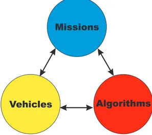
Missions
Vehicles Algorithms
Figure 1.1: In a mission driven development approach the design of both the vehicles and the mission control algorithms are closely linked and developed in order to well fit the requirements and the features of the mission.
In particular, in a mission driven approach, vehicles, control al-gorithms and management software are closely linked and purposely designed in order to well fit the features of the mission they will be
Introduction
engaged in; such a kind of approach allows to draw on parameters which mostly affect the cost of both the vehicles and the missions.
This thesis is related to the topics of marine vehicles for infras-tructure inspections and environmental monitoring, and multi robot coordination and cooperation in ocean survey missions from both a practical and a theoretical point of view.
The subjects treated in this work have been developed in collab-oration with the research group of ISME: the Italian interuniversity centre of Integrated Systems for the Marine Environment, in par-ticular with the Department of Electrical Systems and Automation (DSEA) of the University of Pisa, which I belong to, and the De-partment of Communication Computer and System Sciences (DIST) of the University of Genova.
The thesis is divided in three different parts which ideally follow the evolution of marine technologies during the last years in an ap-proach which leads toward an increasing autonomy of the vehicles and of the mission. Starting from a practical application, in which an established engineering approach has been used, in the first part a feasibility study of a towed semi-autonomous vehicle for underwa-ter pipeline inspection is reported. Going through the second part, scientific and engineering innovations are applied to the design and the evolution of the Flaga, a prototypal AUV tailored to the needs of coastal oceanographic missions; eventually in the third part a new methodological mission driven approach is extended to a theoretical formulation of adaptive on line planning algorithms for environmen-tal monitoring mission to be performed by a team of cooperative autonomous vehicles.
Genova - DIMEC - and ISME. In particular, DIMEC had the respon-sibility of the mechanical and hydrodynamic design, while ISME was in charge of the pipeline sensing apparatus and the automatic con-trol system. Within this project, my personal research activity has been related to the investigation of a passive pipeline detection and tracking method, and the analytical modelling of the pipeline inspec-tion systems (consisting of the underwater towed vehicle, the surface towing ship and the towing cable), as a nonlinear dynamic system. The study of a low cost detection sensor, based on the differential measurement of the gradient of the terrestrial magnetic field around the underwater pipeline, has been followed from both a theoretical point of view and experimental tests, in order to evaluate the field performances of the sensor and validate the theoretical results. As for the analytical modelling of the pipeline inspection system, the underwater towed vehicle has been modelled following the standard methods reported in [1]; as for the towing ship a simplified model has been adopted as described in [2], while the towing cable has been modelled using a finite element approach as described for instance in [3] and [4]. This last choice allows to easily join the dynamic model of the two vehicles in order to obtain the complete mathematical model of the whole system. On the basis of both the performances of the pipeline detection sensor and the analytical model of the whole sys-tem, an automatic control syssys-tem, able to maintain the underwater towed vehicle centred over the pipeline at a pre-specified altitude, has been designed considering the measurement provided by the pipeline sensing apparatus as a feedback information. Inside this project a
Introduction
well based engineering approach has been followed in both the hy-drodynamic modelling of the underwater pipeline inspection system and the synthesis of the automatic guidance system; an innovative contributions is the exploitation of the physical and geometrical fea-tures of the infrastrucfea-tures to be monitored in order to develop an appropriate suite of navigation sensors, while vehicle shape and di-mension are designed on the basis of the inspection requirements. The combined use of the available engineering know-how on ma-rine system modelling and the new magnetic-based detection sensor allowed to carry out an innovative, efficient and faster pipeline in-spection system which reduces the need of trained crews and allows to increase the inspection speed, by contributing to the reduction of the overall mission cost. The prototype of the towed vehicle has been successfully tested at the towing tank of the INSEAN insti-tute (Istituto Nazionale di Studi ed Esperienze per l’Architettura Navale) in Rome. At present, indeed, the project has been selected by the funding agency (Parco Scientifico e Tecnologico della Lig-uria), among more than seventy, as the subject of a new marketing campaign aiming to promote it among the offshore companies.
The second part of this thesis reports the design and evolution of the autonomous underwater vehicle (AUV) F´olaga. Inside this project my contribution has been related to the development of the mission planning and monitoring software application. The mission management system allows to plan and monitor multi-vehicle mis-sions, to store the acquired data in a GIS database and analyze them through thematic maps, charts, and playback of the performed mis-sions. The mission monitoring software has been used during the cruises carried out to evaluate the performances of the vehicle
(Mal-mances of both the vehicle and its control system. A mission driven approach applied to environmental surveys leads to a cost reduction exploiting both the features and the requirements of the missions. This is the case, for instance, in many environmental monitoring missions in which the execution of pointwise measurements, or ob-servations, in a marine area is required. The availability of a vehicle able to navigate on the surface and dive at the selected measurement point, once reached, avoids the installation of expensive underwater navigation sensors and allows to satisfy the mission requirements at a lower cost with respect to a general purpose (traditional) au-tonomous underwater vehicle (AUV). Indeed, the F´olaga design has focused on the observation that a vehicle performing mesoscale ocean measures in shallow coastal waters has to exhibit a mixture of gliders and AUVs capabilities. The introduction of a specific mission goal at the design phase led to the realization of a small, low-cost and easy-to-operate autonomous underwater vehicle suitable for oceano-graphic monitoring missions.
Thanks to the availability of small and low cost autonomous vehi-cles and the progress in communication devices, the implementation of multi-agent missions becomes nowadays a feasible design objec-tive. Multi-robot systems offer potential advantages in performance, robustness, and versatility for sensor-driven tasks such as survey, ex-ploration, and environmental monitoring. In this new scenario there is the need of investigating efficient solutions to the problem of co-ordination and cooperation of the AUVs fleet in the fulfilling of a common mission objective, while minimizing the overall mission cost.
Introduction
The third and larger part of this work reports my main research activity related to the analysis and development of algorithms for en-vironmental monitoring of marine regions, to be performed through a team of cooperating autonomous underwater vehicles, where the mission target is the mapping of environmental quantities with a prescribed accuracy. Within this setting, a new methodological mis-sion driven development approach has been introduced and extended to the definition of coordination and cooperation strategies among the autonomous agents of the team. In particular the proposed co-operating exploration algorithms are strictly connected to both the requirements of the missions and the features of the vehicles which have to perform the missions themselves. The proposed method-ological approach, here specialized to the case of marine environ-mental monitoring missions, can be applied to more general cases in which pointwise measurements, or observation, are required and mobile sensors networks are used. This activity, in fact, is placed in the wider frameworks of the environmental adaptive sampling and mobile sensors networks, and another new element within this thesis is the use of estimation methods which do not require a spe-cific or a priori knowledge of the area of interest, but are able to adapt to the different environmental conditions. This goal has been reached exploiting the approximating properties of radial basis func-tions (RBFs) as the foundation of the estimation method, in partic-ular as for their ability to approximate multidimensional functions from scattered data and to allow for incremental control of the ap-proximation error on the basis of the performed and available mea-surements. Indeed this method allows to control the estimation error in a better way than the one provided by other estimation methods
filtering or other model-based approaches.. After the analysis of the approximation error and the induced performances on the coopera-tive exploration algorithm (in terms of precision and/or number of sampling stations), the case of unsupervised (with neither human surveillance nor relay surface station) autonomous mobile sensors network has been considered. In this case, being the communica-tion range limited, a distributed dynamic programming approach has been employed to solve the measurement point selection prob-lem in a distributed fashion and, at the same time, to take into account the short communication range, allowing the vehicles of the team to communicate after each measurement. In this approach it must be noted that there is not a centralized controller defining a general team policy, whereas each vehicle locally implements its own exploration algorithm. Simulation results in a test case scenario show an emergent collective team behaviour, in terms of team for-mation, indicating that constrained cooperation naturally leads to a coordinated motion.