19
Chapter 2 –
GEOLOGICAL BACKGROUND AND FIELD FEATURES
2.1 IntroductionProducts of the late- to post-Hercynian dyke magmatism have been found intruded within the crystalline basement of the Serre Massif (southern CPO), in southern Calabria, and the sedimentary sequences of Sicilian - Maghrebian chain in central and western Sicily.
This chapter will illustrate the geological background of sampled dykes and provide information about their field features.
A complete list of studied samples, including geographic references, is reported in Appendix 2.
2.2 The Calabria-Peloritani Orogen
The Calabria-Peloritani Orogen (Fig. 2.1) is a composite segment of the western Mediterranean internal Alpine chain, mostly constituted by basement rocks deriving from a poly-orogenic multi-stage history which are presently merged in several Hercynian (Pezzino, 1982; Atzori et al., 1984) or possibly older (Schenk, 1990; Ferla, 2000; De Gregorio et al., 2003; Micheletti et al., 2007; Williams et al., submitted) sub-terranes. These rocks were locally overprinted during different stages of the Alpine metamorphic cycle, which also variably affected Mesozoic ocean- and continent-derived rocks (Liberi et al., 2006; Cirrincione et al., 2008; Fazio et al., 2008). Finally, these basements were definitively stacked by the Alpine-Apennine thin skinned thrusting events in the central Mediterranean area (Ortolano et al., 2005; Pezzino et al., 2008).
The CPO is bounded by two main tectonic lineaments: the Sangineto line (Tortorici, 1982), to the North, and the Taormina line, to the South (Ghisetti et al., 1982).
The structure of the CPO is that of a nappe pile edifice, involving several tectonic slices of basement rocks and Mesozoic–Cenozoic sedimentary sequences.
The origin and geodynamic significance of the CPO is still a matter of debate. Three are the principal hypotheses:
20 1. The CPO would represent a fragment of the Alpine orogenic belt, belonging to the western margin of Adria, emplaced north-westward onto Tethyan ophiolites (Late Cretaceous–Paleogene; Haccard et al., 1972; Alvarez, 1976; Amodio-Morelli et al., 1976; Grandjacquet and Mascle, 1978) and later overridden on the Apennine domains (Late Oligocene–Early Miocene);
2. The CPO would represent a fragment of the southern European continental paleo-margin, thrust and folded south-eastward onto the Adria paleo-margin, starting from middle Miocene, contemporaneously with the opening of the Tyrrhenian Sea (Ogniben, 1969, 1973; Bouillin, 1984; Bouillin et al., 1986; Knott, 1987; Dewey et al., 1989; Gueguen et al., 1998; Rosenbaum et al., 2002);
3. The CPO would represent a micro-continent located between two continental margins, European and African, separated from them by two Tethyan branches and, later involved in the Europe-Adria collision (Doglioni, 1992; Guerrera et al., 1993; Critelli and Le Pera, 1998; Gueguen et al., 1998; Lustrino et al., 2009; Tortorici et al., 2009; Carminati et al., 2010).
The CPO is traditionally divided in two sectors, northern and southern, separated by the Catanzaro trough (Tortorici, 1982). The main differences between the two sectors are the lack of ophiolitic units in the southern segment and the presence of opposite vergences in the two sectors: European for the northern and African for the southern one.
21
Fig. 2.1: (a) Distribution of pre-Alpine basement in Europe (b) Distribution of Alpine and pre-Alpine (Hercynian and/or pre-Hercynian) basement rocks in Calabria–Peloritani Orogen and main tectonic
alignments. Modified after Angì et al. (2010, and reference therein)
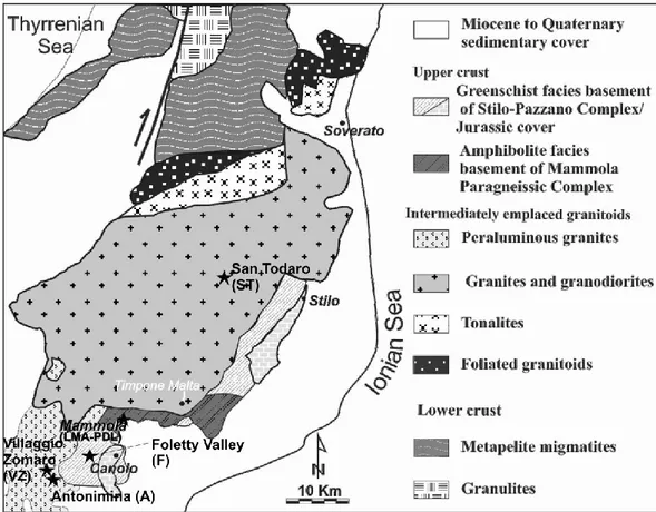
2.2.1 The Serre Massif
The Serre Massif (Fig. 2.1), located in the southern CPO, is one of few places in the world where a nearly complete section of continental crust, with an overall thickness of about 30 Km, is exposed (Schenk, 1980, 1984, 1990). The tectono-metamorphic evolution of the Serre Massif has been constrained by peak metamorphic estimates, available at first only for the lower crust, ranging from 750 MPa at 800 °C to 550 MPa at 690 °C (Schenk, 1984). These data were successively reviewed by Acquafredda et al. (2006), which suggest for the top of the lower crust peak P-T values of 800 MPa at 700 °C. On the other hand, for the upper crustal section of the Serre Massif, characterized by the presence of two metamorphic complexes made up of amphibolite to greenschist facies metamorphic rocks, a detailed P–T path evolution has been reconstructed by Angì et al. (2010). It consists of an initial orogenic cycle characterized by a prograde lower amphibolite facies evolution, developing from P of 590 MPa at T of 500 °C to peak P–T conditions of 900 MPa at 530°C, followed by a retrograde quasi-adiabatic decompressional phase (P=400 MPa; T=500 °C), evolving towards an extensional deep-seated shearing, with P of 300 MPa at T of 470 °C.
22 This last orogenic stage favored the intrusion of granitic bodies, whose progressive emplacement gave rise to a gradually distributed thermal metamorphic overprint with thermal peak conditions at P of 300 MPa and T of 685 °C. This episode was finally followed by a low-pressure cooling path (P=150 MPa; T=500 °C), consistent with the final exhumation stage.
The crustal section mainly consists of:
a. amphibolite-granulite facies metabasites and metapelites (Dubois, 1976; Schenk, 1980, 1984, 1990; Caggianelli et al., 1991; Del Moro et al., 2000; Acquafredda et al., 2006; 2008). These high-grade rocks have been considered representative of the Hercynian lower continental crust (Moresi et al., 1979; Schenk, 1981);
a. metaluminous to peraluminous tonalites, granodiorites and subordinate peraluminous granites, forming a batholith (Serre batholith) intruded between the lower and upper crustal metamorphic rocks (Rottura et al., 1990; Fornelli et al., 1994; Caggianelli et al., 2000; 2007). At its south-western termination the Serre batholith is intruded by the strongly peraluminous Cittanova granites (Atzori et al., 1977; Crisci et al., 1979; D’Amico et al., 1982; Rottura et al., 1990; Graeßner et al., 2000).
b. phyllites, meta-greywackes and meta-limestones (Stilo-Pazzano complex; Colonna et al., 1973) and paragneisses (Mammola complex; Colonna et al.,1973) forming the upper crustal portion (Atzori et al., 1977; Bonardi et al., 1984; Acquafredda et al., 1987; Festa et al., 2003; Angì et al., 2010).
Early studies considered the Serre Massif formed as the result of the juxtaposition of several tectonic slices characterized by distinct tectono-metamorphic evolution, come into contact before the intrusion of the late Hercynian granitoids (Colonna et al., 1973; Amodio Morelli et al., 1976; Borsi et al., 1976; Atzori et al., 1977; Gurrieri, 1980; Del Moro et al., 1986). On the contrary, more recent studies (Schenk, 1980, 1984, 1989, 1990; Bonardi et al., 1984; Thomson, 1994; Caggianelli et al., 2000; Festa et al., 2003) regarded it as a nearly complete continental crustal section that showed a shared tectonic evolution during most of the Hercynian and all of the Alpine orogenic cycles. Studies carried out on the deepest levels of the crustal section have highlighted two different interpretations about the tectono-metamorphic evolution of the Serre Massif.
23 The former one derives from the studies of Schenk (1980; 1989; 1990), which indicate a P-T evolution characterized by an early Hercynian granulite-facies metamorphism connected with an unusually high geothermal gradient synchronous with the development of penetrative deformational phases.
This first orogenic metamorphic phase, for which only poorly defined ages may be suggested (e.g. 330 Ma, Rb–Sr biotite age, Bonardi et al., 1987; poorly constrained lower concordia intercept at 377±55 Ma; Schenk, 1990), was followed by a static metamorphic event, coinciding with extensive granitoid magmatism in the whole CPO at around 300 Ma (U-Pb TIMS and SHRIMP ages; Graessner et al., 2000; Fiannacca et al., 2008). This evolution was interpreted as due to an initial crustal thickening related metamorphism developed at a continental margin above a subduction zone, followed by a continent collision responsible for the first uplifting stages of the deep crust (Schenk, 1989; Graessner et al., 2000).
By contrast, Acquafredda et al. (2006) proposed a P–T path for the top of the lower crust consisting of four segments: thickening and heating, decompression and heating, isothermal decompression, and isobaric cooling.
Serre Massif granitoids can be considered as belonging to two different suites: a main calc-alkaline suite, metaluminous to weakly peraluminous, and a strongly peraluminous suite (Rottura et al., 1990). These granitoids were interpreted as late- to post-tectonic and were probably emplaced along ductile shear zones connected with an extensional regime (Rottura et al., 1990; Caggianelli et al., 2007; Angì et al., 2010). In particular the strongly foliated calc-alkaline granitoids intruded earlier at somewhat deeper structural level, whereas the unfoliated to weakly foliated strongly peraluminous and calc-alkaline types intruded later in shallower crustal domains.
Finally, the upper crustal section cropping out in the south-eastern Serre Massif is characterized by the superposition of two complexes separated by low-angle tectonic detachment, which divide a lower metamorphic grade hanging wall complex (Stilo-Pazzano Complex) from a higher metamorphic grade footwall metamorphic complex (Mammola Paragneiss Complex), both overprinted by static metamorphism induced by the intrusion of the late Hercynian granitoids (Rottura et al., 1990; Fornelli et al., 1994; Angì et al., 2010). The uppermost Stilo-Pazzano Complex, includes low greenschist
24 facies metapelite, metalimestone, quarzite and metavolcanic levels, unconformably covered by composite Mesozoic sedimentary succession (Festa et al., 2003). The lowermost Mammola-Paragneiss Complex, is constituted by amphibolite facies paragneiss, leucocratic gneiss and amphibolite.
Studies carried out by Angì et al., (2010) on the paragneiss rocks of the upper crust revealed that this portion of crust underwent a multi-stage metamorphism, consisting of an orogenic cycle consisting in the following stages: 1) a prograde Hercynian crustal thickening stage reaching lower amphibolite facies conditions; b) a quasi-adiabatic decompression path linked to a first crustal thinning episode; c) a retrograde greenschist facies mylonitic stage consistent with tectonic transport along a dominantly extensional shear zone. This last episode has been associated with the emplacement of the Late Hercynian granitoids, responsible of the late- to post-tectonic pervasive thermal metamorphism. This was finally followed by a retrograde trajectory due to cooling and exhumation.
Fig. 2.3: Geological sketch map of the Serre Massif (Graessner et al., 2000, modified) with location of studied outcrops (black stars).
25
2.2.2 Field features of Serre dykes
San Todaro village (ST samples):
Numerous dykes, dark brown coloured, are intruded with paraconcordant to discordant relationships in the amphibole-biotite-bearing tonalites and biotite granodiorites of the San Todaro pluton (De Vivo et al., 1992) covering an area of about 6 Km2 within the southern sector of the Serre batholith.
Dykes are 1 to 10 m wide and have tabular to lenticular shape, (Fig. 2.4a,b) Contacts with the host rock are only occasionally sharp (Fig. 2.4c), suggesting that emplacement took place when the host rock was not cool and solid, or melt temperature very high. Evidence of ductile deformation is lacking while fragile tectonics caused intense fracturing of both dykes and host granitic rocks.
Dykes are porphyritic, with some thin bodies displaying a textural zoning: a medium-grain size and an high phenocryst abundance typifies the central portion of the dyke, while grain size is fine and phenocrysts are lacking in the border zones.
26
Fig. 2.4: a, b) Variable shapes and thicknesses of the San Todaro dykes (ST) intruding the granitic rocks of the Serre batholith; c) contact zone between dyke and the granitic host rock.
Mammola - Piani di Limina (LMA-PDL samples):
Many dykes have been found intruded in the upper crustal paragneisses of the Mammola Complex (Colonna et al., 1973; Angì et al., 2010) with paraconcordant to discordant relationships (Fig. 2.5a). Dyke shapes are from lenticular to tabular and width ranges from 0.30 to 1 m.
Contacts with hosting rocks are commonly sharp (Fig. 2.5b).
Dykes seldom display a textural zoning from border aphanitic-aphyric portion to central fine grained-porphritic ones. Color is dark green-grey.
27
Fig. 2.5: a) Paraconcordant brown-colored mafic dyke intruding the paragneiss of the Mammola Complex; b) discordant field relationship between dyke and paragneiss foliation; c) mm-sized rounded
quartz xenocrysts occurring within dykes.
Foletty Valley (F samples):
Two distinct outcrops of grey-green porphyritic dykes have been found in the Foletty Valley between Canolo and Mammola villages, crosscutting the phyllitic metamorphic basement (Stilo-Pazzano Complex, Colonna et al., 1973; Fig. 2.6) forming a portion of the Serre upper crust.
They range in thickness between 4 and 8 m and are ~20 m long. Color is light grey-green and a porphyritic texture is clearly visible.
28
Fig. 2.6: Foletti Valley (F) dyke intruding, with discordant relationships, the Serre upper crust phyllitic basement
Antonimina village (A samples):
In this area, light grey dykes have been found intruding the two-mica peraluminous granite of the “Cittanova granite”.
They have tabular to lenticular shapes and are 0.50 to 3 m wide (Fig. 2.7). Contacts with the granitic host rocks are not exposed.
A fine-grained porphyritic texture, with apparent absence of textural zoning, typifies the outcropping rocks.
29 Villaggio Zomaro (VZ samples):
Tabular grey-green colored dykes have been found also in this area intruding the “Cittanova granite”, with discordant relationships and width ranging from 0.5 to 6 m (Fig. 2.8). A coarse-grained porphyritic texture is clearly evident and textural zoning is lacking.
Fig. 2.8: Villaggio Zomaro (VZ) dyke.
2.3 The Sicilian – Maghrebian Chain
The Sicilian–Maghrebian orogenic chain is composed of a thin-skinned south-verging fold and thrust belt developed during the Late Cretaceous-Quaternary Africa– Europe collision (Dewey et al., 1989; Ben Avraham et al., 1990; Mazzoli and Helman, 1994; Tortorici et al., 2009).
Four major structural units can be recognized in Sicily (Fig. 2.9):
1. The Calabride Complex (Ogniben, 1960), exposed in NE Sicily and forming the southern part of the Calabrian Arc (Ogniben, 1973; Bouillin et al., 1986; Monaco and Tortorici, 1995), represents the uppermost unit of the chain. It is made up of crystalline rocks originated in the European margin of NeoTethys. 2. The Sicilide Complex (Ogniben, 1960), because of its composition essentially
made of allochthonous units, has been interpreted as a remnant of an accretionary wedge which developed during subduction of NeoTethyan oceanic
30 crust (Ogniben, 1985; Roure et al., 1990; Monaco and Tortorici, 1995). Oligo-Miocene turbidites (Wezel, 1974), interpreted as fore-arc and trench deposits (Numidian Flysch), are also included.
3. The lowermost structural complex consists of Mesozoic-Palaeogene carbonates derived from the southern (African) margin of NeoTethys and now forming the thickest tectono-stratigraphic unit of the Apennine-Maghrebian thrust system (Catalano and D’Argenio, 1978; Mascle, 1979; Catalano, 1998).
4. The frontal part of the orogenic belt is formed by a post-Tortonian accretionary prism (Grasso et al., 1995; Lickorish et al., 1999), involving the entire sedimentary cover of the African margin and made up of pelagic deposits (Roure et al., 1990; Monaco and Tortorici, 1996).
Fig. 2.9: General tectonic framework of Sicily with location of studied outcrops (black stars). Inset shows the central Mediterranean area with the frontal thrust of the Maghrebian orogenic belt (lines with
triangles) and the main active normal faults (lines with barbs) (after Tortorici et al., 2009, modified).
Sample collection has been carried out in two different sectors of Sicilian fold-and-thrust belt, one located in the central portion where the Sicilide complex outcrops, and
31 the other one situated in the western Sicily where the Permian to Palaeogene carbonates and Miocene (up to Early Tortonian) terrigenous deposits, deriving from the southern NeoTethyan margin (Catalano and D’Argenio, 1978; Mascle, 1979), dominate and are overlain by thrusted rock units of the Sicilide Complex, including Numidian Flysch (Fig. 2.9).
In central Sicily, (Fig. 2.10), samples have been collected from a basaltic sill cropping out in the Leonforte area, on the southern slope of the Altesina Mount (Contrada Vignale). The sill is intruded into the topmost beds of the Lercara Formation, here consisting of 6 m of a well bedded pelagic sequence of cherty siltites and tuffites attributed to the Ladinian (Schmidt Di Friedberg, 1963; 1964; Grasso and Scribano, 1985; Grasso et al., 1993), and passing upwards to 10 m of black shales and micritic limestones, assigned to the Mufara Formation and dated to the Early Carnian on the basis of paleontological data (Schmidt Di Friedberg et al., 1960; Grasso and Scribano, 1985; Grasso et al., 1993).
The contact between the Mufara and Lercara Formations is locally marked by evidence of syn-sedimentary disturbance, such as unconformities, sliding and truncated beds, all likely caused by the intrusion of the sill into still poorly consolidated host rocks. The intrusion is therefore considered post-dating the youngest sediments of Lercara Formation and pre-dating the deposition of the Mufara sediments, so that a late Ladinian - early Carnian age has been assigned to it.
In western Sicily, studied volcanites outcrop in the Roccapalumba – Margana – Lercara area (Fig. 2.11). In the past, Vianelli (1970) described them as alkali-syenite laccoliths enclosed within the Triassic Flysch (Floridia, 1954; Montanari, 1968), belonging to the Lercara Fm., whereas Censi et al. (2000) have more recently described these rocks as tholeiitic basalts enclosed in a deep sea silicoclastic turbiditic sequence referred to the Permian Flysch or Kungurian Flysch.
Triassic Flysch and Permian Flysch are two terms that have been used in literature to indicate the same shale - sandstone sequence belonging to the Lercara Fm.. The latter term however, also includes portion of Mufara Fm. (Montanari et al., 1987).
32 Nevertheless, the depositional age of this formation, as well as the age of the associated magmatism is still debated.
According to some authors (e.g. Schmidt di Friedberg, 1965; Catalano et al., 1988; Catalano et al., 1991) the Lercara Fm. is formed at least by three different lithostratigraphic units:
1. Flysch Unit (Kungurian, i.e. early Permian); 2. Olistostrome Unit (earliest middle Permian); 3. Red Clay Unit (late Permian).
Rocks cropping out in the Roccapalumba-Margana-Lercara area would belong to the Permian Flysch unit according to some authors (e.g., Catalano and Montanari, 1979; Catalano et al., 1991, 1992; Kozur, 1995; Di Stefano and Gullo, 1997a, b; Fig. 2.11).
However, Montanari and Panzanelli (1990) and Di Stefano and Gullo, (1997a, b) point out that the stratigraphic reconstruction and interpretation of Lercara Fm. deposits is complex. The reasons for this are numerous, but include: (1) the strong deformation induced by several tectonic phases affecting the incompetent plastic rocks of the Lercara Fm.; (2) the rare and poorly exposed outcrops; (3) the lack of knowledge concerning both its stratigraphic limits and the basement on which it would have been deposited; (4) the huge quantity of reworked material present in this formation.
The Lercara Fm. is composed by clay-rich sandstones, quartz-rich shales and shales and two distinct types of reworked sediments are present within the laminated, quartz-rich shales and shales. The first consists of rudites, medium-sized to coarse arenites, and fine arenites. These reworked levels always contain lithoclasts with Early Permian–Carnian foraminifera (Carcione et al. 2004). In contrast, the second type of reworked sediments is represented by very large limestone cobbles that yield an exclusively Permian microfauna. Palynological investigations show that clayey sandstones, quartz-rich shales and shales contain Early Permian–Carnian palynomorphs. All these evidences led Carcione et al. (2004) and Carcione (2007) to propose, as previously supposed by Montanari (1968) and Cirilli et al. (1990), a Middle Triassic/early Carnian depositional age for the Lercara Formation and to consider as reworked all the Permian to Middle Triassic materials.
33
Fig. 2.10: a) Geological sketch map of the Mt. Altesina (after Grasso and Scribano, 1985): 1, Diabase sill and enclosing sedimentary rocks; 2, Numidian Flysch: brown clays (a) and quartzarenites (b) 3, Variegated clays; 4, clays with sandy intercalations; 5, “Calcare di base”, gypsum and clays and trubi; 6,
Marly clays grading up to calcarenites; 7, Recent alluvium.
b) Cross-section of the sill outcrop (after Grasso and Scribano, 1985). 1, Cherty siltites and tuffites (Lercara Fm.: Ladinian); 2, Basaltic sill; 3, Micritic limestone and black shales (Mufara Fm.: Carnian;); 4,
34
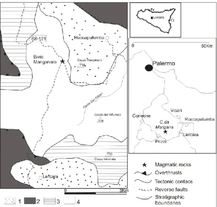
Fig. 2.11: Geological map of the Roccapalumba-Lercara-Margana area (Catalano and Montanari, 1979;
Di Stefano and Gullo, 1997) and localization of studied outcrops. Legend: 1, Mudstone, calcarenites and
polygenic conglomerates of the Terravecchia Fm.; 2, Numidian Flysch; 3, Marls/limestone alternations with halobids, radiolarians and conodonts (Mufara Fm.); 4, Lercara Fm., mostly consisting of siliciclastic
turbidites.
2.3.1 Field features of Sicily dykes
1. Central Sicily: Leonforte village (VG samples)
The studied basaltic sill, cropping out in “Contrada Vignale”, intrudes the Ladinian pelagic sequence of cherty siltites and tuffites belonging to the Lercara Fm. (Fig. 2.12a). Contacts with host rocks are commonly regular and sharp(Fig. 2.12b).
Sill thickness ranges between 1.5 m to 25 m; the color is grey, the texture is holocrystalline and a textural zoning, from fine-grained to coarser portions towards the thickest parts of the body, is clearly evident.
35
Fig. 2.12: a) Leonforte sill (VG) outcrop; b) contact zone.
2. Roccapalumba – Lercara – Margana area (BM, MA samples)
In the Roccapalumba – Lercara – Margana area two different volcanic outcrops, both located near the Lercara town, have been studied.
One is located in proximity of the “Bivio Manganaro” (Fig. 2.13), 3.5 km SO of Roccapalumba village, where a small sill occurs. It has a thickness of about 3.0 m, a dark green-grey color and shows a textural zoning from a medium.-grained equigranular texture in the central portion to a fine-grained porphyritic or aphyric one in the border ones. Samples are labeled as BM.
Fig. 2.13: Bivio Manganaro (BM) outcrop
The second outcrop (Fig. 2.14a) occurs in the “Contrada Margana”, 10 Km west of Lercara town. It consists of large intrusions (laccoliths) with a thickness up to 6 m,
36 characterized by a green – grey color and a holocrystalline texture with a fine to medium grain size towards the inner part of the magmatic bodies.
Samples are labeled as MA.
Characteristically, cm-sized red dykes cut the main body (Fig. 2.14b); they are essentially formed by Fe-rich red plagioclase and have a holocrystalline equigranular texture.
Fig. 2.14: a) Dark grey-colored dyke outcropping in the Contrada Margana; b) cm-sized red dykes crosscutting the main bodies.