2 - THE STUDY AREA
2.1. GEOGRAPHICAL AND GEOMORPHOLOGICAL FRAMEWORK
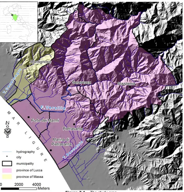
The study area is located in the northwestern part of Tuscany (Central Italy), within the “Regional Basin of Northern Tuscany”, covering the municipalities of Stazzema, Pietrasanta, Forte dei Marmi, in the province of Lucca, and Montignoso in the Province of Massa (figure 2.1). The area extends to about 12 km in the NE-SW direction from the crest of the Apuan Alps until the Ligurean Sea and 13 km in the NW-SE direction between the “Torrente Canalmagro” stream in the north and “Torrente del Baccatoio” stream in the south.
Within the study area, there is a strong morphological contrast in a very short distance, where the costal plain and the very prominent Apuan Alps mountains with their rocky peaks and deep valleys coexist. This situation is similar to that of the major Alps, although the Apuan Alps do not exceed 2000 m.a.s.l. The intermediate relieves are mild hills with an average heights ranging between 200-300 m.a.s.l.
The Apuan Alps are morphological barrier of cold winds from the inter-land and has favored settlement of people and development of various activities. The oldest settlements are located along the slop of Apuan Alps, for easy defense, where as cities and towns were constructed in the lower alluvial fan plains.
In the Stazzema and Seravezza municipalities, the major economy is based on excavation and processing of lapidary materials, mainly marble and other imported rocks such as granites. In the northern part there were also other important activities such as metallurgy and production of chemicals, but currently these activities are strongly reduced and substituted by handcrafts small cottage industries related to building constructions.
Settlement along the costal zone started in the 20th century with various marine activities that mainly developed after the Second World War and Versilia became a target of mass flow for summer holydays. Currently, the costal zone is totally covered with summer houses and hotels. Summer tourism is the major means of income of the costal residing population. In the last century there was a big agricultural development, mainly in the southern part where vegetables, fruits and particularly flowers were cultivated.
The Apuan Alps portion in the study area
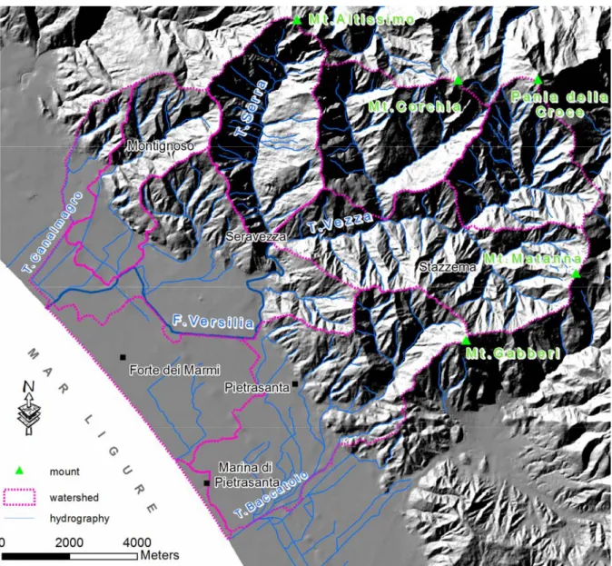
The Apuan Alps form a mountain chain that is continuous and well defined with an average height of 1700 m.a.s.l. The study area encompasses part of the Apuan Alps, in particular as described above, includes the municipal areas of Stazzema, Seravezza, Pietrasanta and Montignoso, where the principal hydrographic basin, object of this study, is developed (figure 2.2).
The most important peaks in the study area are Mount Altissimo (1589 m.a.s.l.), Mount Corchia (1630 m.a.s.l.), Pania della Croce (1852 m.a.s.l.), Mount Matanna (1317 m.a.s.l.) and Mount Gabberi (1108 m.a.s.l.).
Figure 2.2 - Watershed, mounts and hydrography of the study area.
The main cause of the typical Alpine morphology should be searched within the lithological contrast of the formations of dolomitic limestone and the clay-sand rich schist. Enhanced by the multiphase complex tectonic structures, in the latest phase, very high layering angles of unconformity are observed as compared to the original stratification and the dominant schistosity.
The seaward part of the Apuan Alps is very steep with an average slope of 20% and deeply incised valleys where runoff reaches the plain in a short time. This mechanism is the principal factor of transportation of solid materials from the mountains into the plain and the sea. These are also associated with prolonged rainfall events of every season that affect the mountain chain and provoke disasters such as that of the 1996 (D’AMATO
AVANZI &GIANNECCHINI, 2003; D’AMATO AVANZI et al., 2004).
The slops are generally covered with wood, except the steep sides and the peaks, where it is mainly covered by grass. Until very few tens of years, the forest was the main
means of subsistence with important resource of firewood and fruit, but recently the main economic activity is dominated by the extraction of marble. Persons that live in small towns on the sides of the mountains, are mainly rock excavators, if not they move every day to the costal plains to work in productive activities or give services.
The Apuan Alps is among the most important areas affected by complex Karsts with exposed carbonate rocks covering an area of about 383 km2.
Surface features of karst are not developed as expected because the surface morphology and fractures strongly control the forms and the distribution of the epigeous karst. The superficial karstism generally is developed at high altitudes, where there is no vegetation and water infiltration is easy. Other important factors for the development of epigeous forms are the slope of flanks. In the north-western flanks of the Apuan Alps, where carbonate rocks outcrop and the slope is low, formation of sinkholes, snow ponds, inverted erosional structures, and channeled fields are preferentially formed (PICCINI &
PRANZINI, 1989). The sinkholes for example are not very common, few are present in the
northern flank of Mount Tambura, within the group of Le Panie, on Mount Sagro, in the northern flank of Mount Pisanino, in the northwestern side of Mount Sumbra and in the northwestern side part of Mount Altissimo (PICCINI, 2002). Other types of karstic
structures that are found in the area are like “Marmitte dei Giganti” that are located along some river courses and supply the water basin of Serchio river (Fatonero and Anguillaia). Along the seaward side, that is the objective of this study, the epigeous type of karstism is very rare. The steep slope is in favor of superficial drainage and runoff. Therefore, the typical karstic microforms are like small channels and kamenitza or corrosion ponds.
In contrast to the epigeous karstism, the ipogeous karstism is among the most developed in Italy and Europe, with a maximum depth of 1200m and length of 55 km (PICCINI, 2002). A total number of more than 1000 cavities are registered on the Regional
Karst monitoring book (FEDERAZIONE SPELEOLOGICA TOSCANA, 2002). In this area there are
karst caves most important of the Italy (19 among the deepest and 8 among the most extended). For example the Abisso Paolo Roversi cave is the deepest (-1250 m) and Corchia-Fighiera-Farolfi karst complex is the most extended (60 km) in Italy. Some karst well and galleries are located at high altitude, proving high groundwater level that have been abandoned with the reduction of the sea level. The presence of this cavities at 1500 m.a.s.l. of altitude and the dating of speleothems in many caves of Apuan Alps indicate that the karst started on upper Pliocene (PICCINI, 1994; PICCINI et al, 2005) before the
Apuan Alps uplift. Alternating phases of uplifting and stagnation (lower-middle Pleistocene) have favoured a gradual extension of the deep karst and a reorganization of existing networks, especially in the south-western side of the massif. About these
aspects the Monte Corchia complex can be considered one of the best examples of polycyclic karstification in the world (PICCINI et al., 1999).
Other spectacular forms present in the study area are like Mount Forato, where its peak has 30 m diameter hole due to erosion by rainfall and wind. Monte Procinto is the second example where the peak resembles a pancake with steep wall all around it.
The morphology of the mountainous area is affected by the extraction of marble starting from the Roman times. The extraction of marble has double effect, both in excavating very big volumes and the by-product of various sizes forming detritic flow called “ravaneti”. In the last few years reutilization of the by-product and extraction in form of tunnel and vertical holes has contributed to lower environmental impact, at least morphologically.
The costal plain
The costal plain, objective of this study, is part of the northern Toscana Regional basin (L. 183/89). The study area extends in parallel to the Ligurean coast in NE-SE direction, with an area of about 55 km2, elongated in NW-SE direction to 12.5 km and a mean width from the foots of Apuan Alps to the sea, ca 4.5 km.
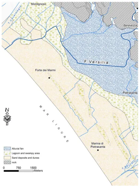
Morphologically the costal plain can be divided in to three physiographical strips that are almost parallel to the costal line (figure 2.3).
1. The foothills strip is linked by the foot of the Apuan Alps and it is formed by
alluvial fans of rivers that run from the Apuan Alps and by slope detritic flows reworked and distributed by waters. The alluvial funs do not exceed some tens of meters in height and start from the elevation of 30-50 m a.s.l. In the area the most important alluvial fun is that of “Fiume Versilia” river, but there are a number of smaller fans such as that of “Torrente Baccatoio” stream. The funs are mainly composed of carbonate (Marmi and Grezzoni) gravels that come from the Apuans. The carbonate gravels are partly cemented forming conglomerate rock, due to the percolating waters rich in bicarbonate that took place in climatic and morphological condition different to the present. This should have taken place in colder and wetter conditions (SALVATORI & SPANDRE, 1995).
These fluvial deposits are terraced with escarpments that attain 8 meters in the most northern part of the plain. In the distal part the alluvial funs appear truncated, an escarpment that runs parallel to the cost is clearly visible and it emerges from a highest of about 5 meters (SESTINI, 1950). This is the limit where the sea has reached during the
Versiliana transgression, before the westward progradation of the cost that has formed the actual plain. In the southern part the alluvial fun strip is narrow without clear terraces. This is evidence that this part during the structural depression has continued to sink after the last glaciation.
Figure 2.3 – Image of the three strips
2. The intermediate strip is topographically the most depressed part with many
zones below the sea level. It corresponds to the lagoon and swampy area, isolated from the sea by the development of high dunes and littoral sands. Most parts of the swampy area have been reclaimed and at present are limited to Massaciuccoli Lake and Porta Lake. The later is already limited to a small humid area covered by grove of reeds. The soil is very fine (lime to clay with peat) and shows, alluvial, lagoonal and swampy origin. The hydraulic operation of this zone is controlled by the “Consorzio di Bonifica delle Versilia” by a series of channels of “low level waters” and “high level waters”. It is important to note that the intermediate strip is subjected to higher level of subsidence as compared to the costal area. This is for two important reasons: the soil along this strip is very fine and very young that can be easily compressed and the above mentioned
hydraulic operation has dramatically reduced the water content of the soil and caused a major compaction and reduction in volume.
3. The third strip, the littoral part, is formed by sand deposits of the beach and
dunes. The dunes, although not higher than 4-5 m, are completely levelled due to the intensive urbanization that has strongly affected the costal area in the last 60 years. Better conserved dunes are located between Forte dei Marmi and Cinquale. The width of this strip increases from NW to SE, from about 1 km at Marina di Carrara and attains 3-4 km at Lido di Camaiore with a mean height of about 2 m a.s.l. The strip is formed due to the accumulation of sand transported by water that flow from mountain area, mainly by the rivers Magra and Arno (AIELLO et al., 1976; GANDOLFI & PAGANELLI, 1975; SAGGINI,
2.2 – HYDROGRAPHIC FRAMEWORK
Hydrographically the Regional Basin of Northern Tuscany is confined by the basin of “Fiume Magra” river to the north (limit: Parmignola stream), the basin of “Fiume Serchio” river to the east (limit: Apuan crest) and south-east (limit: Camaiore river) and the Ligurean sea to the west. The Northern Tuscany Basin is not a real hydrographic basin, but it consists of many river courses that origin in the Apuan Alps mountain chains directed to the sea. The total population number within the basin is about 224.000 with a mean density of about 598 habitants/km2. Table 2.1 shows the principal basins that form the Northern Tuscany Basin, among which the “Fiume Versilia” river and “Torrente Baccatoio” stream, that are included in the study area.
Table 2.1 – Characteristics of Northern Tuscany basin
Name Basins area (Km2) River length (Km)
Torrente Carrione 46.6 15.4
Torrente Ricortola 6.9 8.0
Fiume Frigido 63.2 17.5
Fiume Versilia 91.0 24.0
Torrente del Baccatoio 27.6 10.9
Fiume Carrione 48.8 11.7
Generally the water flow is very rapid in a relatively short distance in a generalized E-W direction, slopes are high in the mountainous and hills (high- medium basin) and low in the plain (low basin) where these are embanked to relatively high level. The basin has peculiar morphological setup, with the high mountain chains of the Apuan Alps only few km far from the sea (about 15 km). This morphology intercepts the humid wind that comes from the Mediterranean Sea and Atlantic Ocean and this has determined the high mean annual rain fall of the area (sea chapter 2.5). This characteristic, the strong steepness in the mountain basins, the presence of the detritic cover and high population density cause conditions of destabilization and hydrogeological risks.
The study area is crossed not only by F. Versilia river but also by other important stream like T. Baccatoio that becomes “Fosso Motrone” ditch near the coast, and “Fosso Fiumetto” ditch. These water flows start in the adjacent high relives and get in to the sea crossing the costal plain, following not always natural courses. In fact commonly rivers are artificially deviated to improve the territorial utilities.
Other than the principal rivers there is a dense grid of canals and drainages. Among these there are channels know as “high water” distinctly separated from the “low water”.
The channels of the high water are natural and flow toward the sea. These channels collect all the water that drain from the higher relief and lead them to important rivers. The low level water channels, on the other hand, have been used to drain the swampy zones in the intermediate area (see previous paragraph), to drain the runoff from the mountains and the meteoric water. In the later cases it is controlled by dewatering plants that collect the water towards channels of the high water and let them flow finally into the sea. Pumping by the dewatering maintain the piezometric level of the ground water under the ground surface for the whole year.
The Versilia River is the major water flow in the study area. Its rainfall collecting basin is 116 km2 wide, but the hydrogeological basin is expected to be very large, because also includes part of the adjacent F.Serchio hydrographic basin (GIOVANNINI,
1993). The principal course of the Versilia River is 22 km long and has various names in different segments. It starts from a spring at an elevation of 780 m near the “Foce di Petrosciana” and the first segment is known as Versiglia. Near the town of Cardoso it joins the channel of Deglio and it is named as “Torrente Cardoso” stream. At Ponte Stazzemese it joins the “Torrente Mulina” stream and becomes “Fiume Vezza”. After a short distance the channel of Giardino joins and reaches the town of Seravezza where it is joins the “Fiume Serra” river and becomes “Fiume Serravezza” river. Once it reaches Corvaia the river flows in the costal plain of Versilia and it is named as “Fiume Versilia” river. At the beginning it passes along the southern part of Querceta and confines the municipality of Pietrasanta and at last follows the limits of the Forte dei Marmi. Before its deviation, that took place in the 700, the F. Versilia used to pass along the western part of Pietrasanta town flowing in to Ligurean sea at the Motrone locality. The old river course was similar to that of the 1996 disastrous runoff, where it had broken the embankment flooding the major part of the coastal plain of Versilia (CAREDIO et al.,
1996). Its deviation is in fact at Pontestrada, where its bed is embanked and rectified towards NW. Successively the river collects water from the Bonazzera channel and Rio Strettoia and enters the Foce del Cinquale, the old entrance of the Porta Lake, which has been drained recently. The deviation of Versilia River was purposely done to utilize its detritus to drain this lake. The area is completely reclaimed and actually there has remained a small swampy area that deserves protection for its ecological and natural values. Following the morphological analyses (LEONARDI, 2005), the main water device
follows the peaks of the major mountains and it is parallel to the coast. The major mountains from north to south are: Mt. Cavallo, Mt. Tambura, Mt. Altissimo, Mt. Pania della Croce, Mt. Matanna and Mt. Prana. The highest point is represented by the peak of Mount Pania della Croce at 1854 m. a. s. l. The northern limit of the basin attains an
altitude between 1000 and 1500 m. a. s. l. The mountainous closure of the basin at Seravezza is located at an altitude of about 45 m. a. s. l. The hydrographic network in the upper parts of the Vezza stream is a well developed dendritic type. This development is related to the presence of carbonate rocks in the summit parts and poorly permeable rocks, mainly phyllites and Pseudomacigno in the rest portion of the basin. The river beds in the mountainous areas are characterized by deep and steep walls with straight flow direction and little detritic materials. Below the confluence of Cardoso and Mulina streams there is a clear asymmetry in the network. The tributaries to the left hand side of Vezza stream have very limited branches, whereas on the right hand side are very long although these have also developed few branches. This aspect can be related not only to morphological factor, in which the right hand side of the basins starts usually from altitudes greater than 1500 m. a. s. l., whereas on the left side the peaks never exceed 1000 m. a. s. l, but also to structural factor such as the different inclination of the layers in respect to the slope inclination. River Serra is a unique case in which morphology of its course is strongly modified by many deviation barriers. At last the high steepness of the slope near to the end of the valleys and the evident deep cut of the valleys both in the mountainous and plain areas define a highly dynamic situation of the basin that is also related to the dynamic uplifting of the Apuan Massif due to the neotectonic evolution of the area and eustatic variation of the sea related to various glaciation periods. The Versilia River has a karst alimentation and a torrential regime (GIOVANNINI, 1993). During
heavy rainfalls the river is filled with water in a short time that may cause disaster like the flooding event of the 1996 (CAREDIO et al., 1996). As regards the flow rate, at the
section of Corvaia the average flow rate is measured to 5 m3/s, a minimum of 100 l/s and a maximum of 700 m3/s. The minimum flow is related to the karst springs mainly from the mountainous zone such as the spring of Polla, Giardino and Fontanacce. These springs maintain a significant flow rate of the river even during summer. The F. Versilia River has an important role in supplying water to area that is crossed by its flow, particularly the coastal plain.
2.3 – GEOLOGICAL FRAMEWORK
In this chapter the geological aspects both at regional and local scales will be discussed. And the initial part. the tectonic and geodynamic of the Apuan Alps is described in relation to the adjacent coastal plain. Successively the paleogeographic evolution is treated and at last the details of lithological units of the mountainous area and the unconsolidated sedimentary deposits of the coastal plain are presented. For further details a list of references are cited in the text.
Tectonics and geodynamics
The geological and structural aspect of the north-western part of Tuscany is related to the orogeny of the Northern Appennines. The Northern Appennines is a NE verging chain composed of an oceanic tectonic unit (Liguri Unit), that is tectonically overthrusted by the tectonic units of Toscana and Umbro-Marchigiana, both derived from the margins deformation of the Adria plate.
The orogeny of the northern Apennine has many phases of development (figure 2.4) characterized by different tectonic regimes. During the initial phases of compression, overthrusting of the western units on top the eastern took place (CARMIGNANI et al., 1978)
and has formed a tectonic building composed from top to bottom by the Liguri Unit (s.l.), the Tuscan Nappe, the Massa Unit and the Apuan Unit. A successive phase of extension, initially ductile, allowed denudation and uplifting of the metamorphic complex (CARMIGNANI & KLIGFIELD, 1990). This was followed by another phase of extension, this
time brittle type and brought a high angle fault.
The genesis of the northern Appennines can be schematically subdivided in to two principal phases. These have given a definitive closure of the Ligure-Piemontese ocean after the collision of the Sardo-Corso block with the Adria plate. This collision, as describe above, has generated the initial compressive zone (phase D1), that had progressively propagated from SW to NE and from the internal to the external parts of the mountain chain. During these early compressive phases, due to the convergence of plates, the subsidence of a slab eastwards has uplifting and piled up the Ligurean unit according to the mechanism of frontal accretion or offscarping.
Other authors propose, instead, the subduction of the slab to westwards (ABBATE et
al., 1980; PRINCIPI & TREVERS, 1984; FACCENNA et al., 1996; BORTOLOTTI & PRINCIPI, 2005).
In the upper Eocene – early/middle Miocene the major continental collision of the Sardo-Corso block against the Adria plate took place with a subduction lithosphere immerging to the W (BOCCALETTI et al., 1971; DOGLIONI et al., 1998; FINETTI et al., 2001; MARRONI et
overthrusting of the internal units, Liguri unit, over the Tuscan Nappe. The later has been doubled, as indicated by the overthrusting of Tuscan Nappe over Apuan Unit. The D1 phase has generated a green schist facies of the Apuan Unit (Tuscan metamorphic series) (BARBERI & GIGLIA, 1965; GIGLIA, 1967; CARMIGNANI et al., 1978). Metamorphism of
the central part is characterized by temperature of 350-450 °C and pressure of 0.4-0.6 Pa (CARMIGNANI et al., 2004; MOLLI & VASELLI, 2006).
During the collision the Unit of Massa was also involved, that is interlayered between the Tuscan Nappe and the Apuan Units, undergoing a metamorphic grade higher than the last one (GIGLIA, 1967). The sense of the transportation of the units is
considered to be from SW to NE based on the vergence of the isoclinal folds of the metamorphic units and extensional lineation (CARMIGNANI et al., 1978).
Starting from Mid Miocene, the compressive structures of the internal mountain chains are affected by extensive tectonics (D2 phase), which is coeval with the opening of Balearic Basin and successively the Northern Tyrrhenian Sea. The phase D2 has caused the denudation and uplifting of the metamorphic complex that is formed by both the Apuan and the Massa Unit. During this phase long bands of ductile openings inclined respectively to the NE and SW were formed in north-eastern and south-western part of the massif (CARMIGNANI & KLIGFIELD, 1990; CARMIGNANI et al., 1991).
In the upper units (Tuscan Nappe and Liguridi s.l.), the extensional tectonic has generated deformations that ranged from brittle-ductile to purely brittle. The Tuscany sequence, both metamorphic or non, are separated by a continuous cataclastic horizon, composed from metamorphic and non metamorphic components, known as “Calcare Cavernoso” which had functioned as a thrust unit that verges to the NE in the D1 phase and as a detachment surface in the D2 phase (CARMIGNANI & KLIGFIELD, 1990).
Between the Upper Miocene and Pleistocene, in the upper units of the Apennine edifice, high angle and NW-SE trending straight faults system was developed. These faults also formed a Horst - Graben system associated with volcanic activities with consequent dislocations of the previous compressive phase structure (D1) and extensive phase (D2).
Figure 2.4 - 3D Reconstruction of the evolution of the Northern Appennines orogenesis (modified from FINETTI
et al., 2001).
In general, the tectonic structure of the Apuan Alps is characterized by very well developed folds at any scale of observation. An evident planar anisotropy characterizes most of the metamorphic rocks of the Apuan Alps Complex and it represents the main metamorphic foliation related to the D1 phase of deformation. Such foliation, in the isoclinal folds frequently not cylindrical (sheath folds), form an axial plane foliation that measures from millimetric to many kilometric and it is associated with an extensional lineation (L1). The later is interpreted as the main transport direction of tectonic units in the Northern Appennines.
In fact, the piled structure of D1 overturned to the east, the angular relationship between the main foliation and the first order tectonic contacts and the extensional lineation L1 are in agreement with the direction of transportation of the various tectonic units that is SW-NE.
The deformation event D2 is characterized by the development of an opened to closed folds, variously not cylindrical, with dimensions that varies from millimetric to plurihectometric in association with a generally sub-horizontal axial plane crenulation cleavage. Based on the observed structures, three different folding phases (F1, F2, and F3) were recognized. Interpretations regarding their importance or overlap on a regional scale could be variable (CARMIGNANI & GIGLIA, 1975, 1983, 1984; CARMIGNANI et al., 1978;
KLIGFIELD, 1979; BOCCALETTI & GOSSO, 1980; BOCCALETTI et al., 1982, 1983b; COLI, 1990;
MORATTI et al., 1989; CARMIGNANI & KLIGFIELD, 1990; MOLLI & MECCHERI, 2000; MOLLI &
VASELLI, 2006).
The first two phases have given rise to the present Metamorphic Core, whereas the third phase slightly folds the edifice that was already formed. The interaction between the two folding phase F1 and F2 has determined the rising up of the dominant structures that characterizes the actual metamorphic core of Apuan Alps. These are the syncline of Carrara, the anticline of Vinca, the syncline of Orto di Donna and the anticline of Monte Tambura, all oriented in NE-SW direction. In particular, the structures related to F2 phase show both linear elements oriented in NW-SE direction and transversal elements oriented in NE-SW direction. The first formed normal faults and the second transversal form transcurrent faults. The folding phase F3 (8-10 Ma) could be caused by late exhumation that brought the metamorphic core complex to the top. Until 4 Ma, the exhumation of the Apuan Alps was mainly due to denudation (FELLIN et al., 2007), that is
still active as a proof and the rate of uplifting is about 1.0 to 1.2 mm/yr (BALESTRIERI et
al., 2003; BARTOLINI, 1999). The structures, that are effects of the three deformation
phases in the Tuscan Nappe, are characterized by a first schistosity (S1) developed mainly in the clay dominated rocks within the limits of anchizone, and by a second less evident cleavage (S2) associated with piling structures that have deformed S0 and S1 systems. Even though there are many analogies between the Metamorphic Complex and the Tuscan Nappe, it is important to note that in the first case post collision extension is recognized mainly by the distortion of the internal structure that is concentred in the fault zone with variable thickness. While in the second case, characterized by non metamorphic-anchimetamorphic unit, the post collisional extension is recognized mainly as fragile deformation represented by normal faults of high and low angles. These overlay young rocks on top of older rocks with the absence of big interval stratigraphic successions.
The important faults are listric type and their root extends until the detachment level of Calcare Cavernoso. The multiphase folding is associated to the 3 main events of metamorphism of the area. These have an age of Late Oligocene (27-24 Ma), Middle Miocene (12 Ma) and Late Miocene (10-8 Ma) (KLIGFIELD et al., 1986; FELLIN et al., 2007).
Correlation of the 3 metamorphic event peaks and the 3 phases of folding, appears be simple and direct, but it is neither clear nor not proved (BONINI et al., 2008).
Most of the modern texts are based on the hypothetical well defined model of exhumation, in which the first phase of folding was assumed to be developed only in the context of convergence. The second is related to an extensional event that was responsible for the exhumation of the metamorphic core of the Apuan Alps in a Basin and
Range style (CARMIGNANI & KLIGFIELD, 1990; CARMIGNANI et al., 1994), and it is in
agreement with the model of a Platt. At last, this hypothesis considers that metamorphism in the Apuan Alps is Core Complex metamorphic type (CARMIGNANI &
KLIGFIELD, 1990; CARMIGNANI et al., 1991), in which the structure is related to the lower
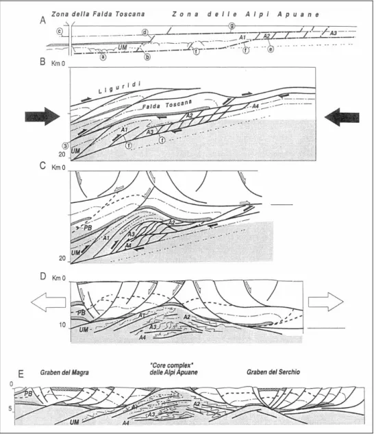
Sardo-Corsa plate, where as the Tuscan Nappe and the upper units are derived from the upper plate of Adria. In this extensional context the detachment fault is located within the Calcare Cavernoso (figure 2.5).
Figure 2.5 – Evolution of the shear zone of the Apuan Alps (from CARMIGNANI & KLIGFIELD, 1990; CARMIGNANI et al., 1994). A) Pre collisional configuration, showing traces of an important thrust and flat-ramps structure. B) Duplex structures development in the Apuan Alps. The metamorphic rocks are in darker tone. C) Development of an antiform trough fast underplating and thinning of accretional prism. D) Extensional phase in a Basin & Range style that allowed the uprising of the Apuan Alps metamorphic core. E) Complete development of the extensional phase, with the exposure of the Apuan Alps confined by the Magra and Serchio Grabens.
The exhumation mechanism and in general the geodynamic process evolution of the study area has been a point of discussion and debate. Accordingly, many hypotheses were formulated. Among these one thesis considers that the two folding phases were developed in a convergent regime in deep crustal shear zone (figure 2.6), active between Late Oligocene (F1 27-26 Ma) and Mid Miocene (12 Ma) (BOCCALETTI et al.,1983b). The
third folding phase in agreement with the first hypothesis is considered as a late and less important event. The main difference of these two models is related to the events of the folding phases. The second model is schematically presented on figure 2.7. According to BONINI et al. (2008), the folding phases of F1 and F2 gave together the uplifting of the
Apuan Alps to its present configuration, with an effect on a regional scale.
Figure 2.6 – Alternative schematic model for the evolution of the Apuan Alps shear zone. a) Development of
the crustal shear zone of the Apuan Alps. b) Details of the shear zone during the folding phase F1 (27-24 Ma). c) Details of the shear zone during the folding phase F2 (12-14 Ma); this phase indicates that the refolding of the first fold generation can bring up the interference patterns even to a map scale. d) Further development of the crustal shear zone; as a consequence of the change of the eastern part of the shear zone, the Apuan Alps change from roof type of plate to bed type still uplifted (e.g. HSU, 1992; CHEMENDA et al., 1995, 1996). e) The uplifting is associated with the elimination of the roof of the upper levels that were subjected into an extension due to the development of the Viareggio basin in the west. The active crustal thrust moves to the east uplifting the major anticline thrust of Corfino.
The origin and evolution of the Apuan Alps of Versilia are related to late tectonic phases of the Northern Appennines. This is starting from the Upper Miocene, when these structures were affected by the large scale extensional tectonics that gave origin to “Horst” and “Graben” type structures. The negative morphostructures, alternating with high structures were principally formed by the normal fault system spiking NW-SE, i.e. Apennine direction. These were associated with secondary transcurrent fault systems with antiapennine direction. Along these structures, dislocations were formed to separate sectors with different tectonic evolution and paleogeography (BARTOLINI et al., 1982;
BOCCALETTI & COLI, 1983a). Versilia together with the coastal plain of Pisa and the
“Pleistocene terraces” of Livorno belong to a big triangular depressional basin (figure 2.7). Limits of the depression are represented to the East by the extensional structures at the foot the alignment of the Apuan Alps, Monti d’Oltre Serchio, Monti Pisani. To the west it is limited by a system of faults, with extensional characteristics, submerged under the sea, but with opposite immersion, that delimit the uplifted structures from the submerged ridge of Viareggio, to the South by the Monti Livornesi (MAZZANTI &
PASQUINUCCI, 1983). This basin extends further to the north following the Magra Valley
with a minor width (Magra Graben) (FEDERICI & MAZZANTI, 1995).
Figure 2.7 – Tectonic set up of the Pisano-Versiliese Coastal Plain (from MAZZANTI &PASQUINUCCI, 1983).
The total tectonic subsidence of the Pisano-Versiliese basin is estimated to be not less than 4000 m (MAZZANTI, 1995). Whereas the Apuan relief is uplifted to about 2000 m
a.s.l. and in the Viareggio zone base of the Pliocene substrate rock is identified at a depth of about 2000 m by geophysical prospection (FEDERICI, 1987; MAZZANTI, 1995).
Paleogeographic evolution of the coastal plain of Versilia
Based on the research of BLANC (1934, 1936), FEDERICI (1993), MAZZANTI & RAU
(1994) and MAZZANTI (1995), it is possible to reconstruct the formational history of the
coastal plain of Versilia. It starts from the Upper Miocene, when on the western margins of the Apuan Alps chain started extensive events to give the present morphological lineaments and stratigraphy. This evolution has led to the formation of basins and tectonic depression of the “neoauthoctonic” phase, in which the Neogenic and Quaternary sediments are deposited. These are products of the tectonic events and other external phenomenon happened during this event, such as salinity crisis of the Mediterranean Sea during Messinian and the eustatic oscillation of the sea level due to glaciations.
During the Pliocene age, the present coastal plain has registered a marine domain (Low and Middle Pliocene) and a continental phase that have brought the area to an extensive plain during the Upper Pliocene that extended until the present Corsica and Sardegna (DELLA ROCCA et al, 1987). During the lower Pleistocene, the “Santerniana”
transgression related to the formation of newly collapsed basins were developed, in which the sea invaded the coastal plain until the western limit of the Apuan Alps in Versilia. Whereas in the Southern area of Pisa there was a deep gulf (the Sinus Pisanus) that extended to the western foot of Monte Pisano (LAZZAROTTO et al, 1990; MAZZANTI,
1995).
The Pleistocene ended with the termination of this cycle and appearance of strip of land beyond the present coastal line. Starting from the Upper Pleistocene, alternation of transgression and regression of the sea and the associated glaciation accumulated very thick strata of detritic material. The maximum sea ingression was during the Tyrrhenian period, when the global sea level reached a high of +7 m in respect to the present (LAZZAROTTO et al., 1990).
The end of Upper Pleistocene is marked by the last glaciation “Wurm”. This period is characterized from repeated climatic variation that produced many transgression submerging the coastal plain and denudation of the emerged land. The cumulative result was a continuous evolution with deposition of sediments of various origins, such as coarse grain from alluvial fans of rivers flowing from the Apuan Alps into the plain, littoral sand strips forming barriers to lagoons and swampy areas beyond the dunes that still have large dimensions. The lake of Massaciuccoli, swampy area at the back of Viareggio, and extinct lake of Porta, behind Forte dei Marmi are remnants of many water bodies that were formed in the Versilian coastal plain. The last marine transgression named “Versiliana” followed by the glaciation during the last stage Wurmian glacial expansion (Wurm III) and the interglacial equilibrated climatic conditions during the Holocene period have produced the present Versilian coastal plain. The combined actions that have
contributed are derived by the uplifts of the sea level, by the sediments transport of the rives flowing into coastal plain and, at last, in the historical times, by the contribution of anthropological activities (DELLA ROCCA et al., 1987). The sea has reached the present
level starting from a minimum of about 100–110 m below the current level (18÷20 ka B.P.; FEDERICI, 1993) (figure 2.8).
Figure 2.8 – Sea level uplifts of Tyrrhenian Sea from 14000 years BP to present (modified from Lambeck et
al., 2004).
This uplift of the sea level has led to the submersion of the western flat areas, near the present coastal line (MAZZANTI, 1983). Core drilling in the internal coastal plain of
Tuscan (LONGINELLI et al., 1972) show that there was an old beach line sub parallel to the
current one situated at a depth of more than 110 m. Based on the radiometric analyses and 18O/16O ratio studies of the calcium carbonate of shell fossils, the above mentioned age (ca 19 ka BP) is correlated to the youngest maximum glacial extension. Further evidence is found in the fossils recovered from core samples, recognized to be typical of littoral environment (LONGINELLI et al., 1972). The highest peak of this transgression was
between 9,4 to 6,3 ka BP. During this period, Versilia had a paleogeography composed of a series of gulfs and lagoons separated from the sea by submerged barriers and dune stripes interrupted by channels (NISI, 1999). During this phase the sea has reached the
western feet of the Apuan Alps, including the high level river fans, as indicated by the seashore sand found as exposure or from drilling (DELLA ROCCA et al., 1987). Successively
with the reduction of the sea level, the coastal plain is less influenced by the sea, due to the formation of permanent littoral dunes (DEVOTI et al., 2003), that separated the sea
from the swampy areas. These were first lagoon and successively transformed to lakes and/or swamps, in which an important volume of organic matter is deposited (MAZZANTI
hypothesis related to velocity reduction of the sea level uplifts (FEDERICI & MAZZANTI,
1995), a second hypothesis is proposed. In particular this hypothesis affirms that the main cause could be a reduction of the sea level by about 3.5 ka BP (figure 2.9). This could be related to a cold climatic phase (ALESSIO et al., 1992).
Figure 2.9 – Central Tyrrhenian sea level oscillation during Upper Pleistocene – Holocene (from ALESSIO et al., 1992).
During the historical times, with the introduction of agriculture and the contemporaneous deforestation of vast areas, soil erosion increased significantly and as result detritus transported by rivers also increased. Also sea level has increased, the above operation has caused a contemporaneous advancement of the beach. A reconstruction of the variation of the coastal line was done during the VIII Century B.C. (Bronze Age) (figure 2.10), based on the initial traces of human activities in the coastal plain. In fact, alignments of the archaeological sites follow with some degree of precision trend of the coast line (in figure 2.10, see sites 15, 18, 19, 20 and 24). During the Roman times, the coast line should have been displaced by about 1500 m towards the sea as compared to the present position (FEDERICI & MAZZANTI, 1995).
Figure 2.10 – Reconstruction of the old coast lines in the Versilia coastal plain (from FEDERICI and MAZZANTI, 1995).
Important hydraulic plants were constructed starting from the XVI Century AD ordered by the Republic of Lucca to reclaim the coastal strip from the vast water body and thick vegetation, so that it can be used for agriculture and eradication of malaria. At the same time, in the coastal plain of Pisa, important hydraulic works were performed (meandering cut of Serchio and Arno river courses and the “taglio ferdinandeo”, a deviation to NW of the mouth of Arno river) and this caused deposition of materials in the last two centuries more than the previous thousand years (FEDERICI & MAZZANTI, 1995).
Regarding the flow of sediments along the coast, studies of morphology and grain size (AIELLO et al., 1976) and petrography (GANDOLFI & PAGANELLI, 1975) were conducted. All
studies agree on the existence of a drift mainly oriented to the south from Bocca di Magra to Forte dei Marmi, and another one towards north from Bocca d’Arno to Marina di Pietrasanta (figure 2.11). In the last 4000 years, the whole coastal plain is in a fast increase expansion, as a result of deforestation and introduction of agriculture that has caused a fast increase of erosion and strong increase in solid transport by the rivers. The
progression (progradation) of the coastal line was mainly due to the mass transport of the Magra and Arno rivers. Sea currents from the mouth of Arno river toward north and from the mouth of Magra river towards south meet at Forte dei Marmi as indicated by the distribution of the sea sediments (bathymetry and granulometry). Due to the construction of the Port of Marina di Carrara during the 1920’s, the trend of advancement was inverted and transportation of littoral sediments from north was interrupted. The consequences were increment of the shore to the north of the port (+ 44,6 meters between 1938 - 1998) and erosion of the southern part (- 106 meters during the same period) (CIPRIANI et al., 2001). The extraction of solid material along the Magra river
course that started after the 2nd World War has worsened the situation.
Figure 2.11 – Direction of littoral sediments movements (transport) between Livorno and Bocca di Magra. At present the beach of Marina di Carrara is in a phase of erosion to the south at high speed despite the action taken. Acceleration of the erosion was partly due to the interventions. The consequences of the interventions is displacement of the erosion to the south, in which at present it is located along the coast line of Poveromo and has started the beach of Forte dei Marmi. Along the beach of Marina di Pietrasanta and Viareggio, the rate of erosion is minor due to the construction of the port at Viareggio. This has interrupted the drift of the sand brought by Arno river to the north.
Stratigraphic Units of the Apuan Alps and the coastal plain
The Apuan Alps are made up of the metamorphic core of the Northern Appennines, where the basement and the associated cover sedimentary rocks of the passive margin of the Adria continental plate, are exposed.
The metamorphic rocks are exposed in a tectonic window, under the non metamorphic succession of the Tuscan Nappe that confines the metamorphic core in three sides. It is only along the coastal zone, where the contact between the metamorphic and the non metamorphic, is buried under the alluvial cover deposits of the coastal plain (figure 2.12).
Figure 2.12a - Geological sketch map of the Apuan Alps (From “CARTA GEOLOGICA REGIONE TOSCANA” – Tectonic map sketch, Sheet Massa Carrara-249 and Viareggio-260, modified).
Figure 2.12b – Geological cross section of the Apuan Alps (From “CARTA GEOLOGICA REGIONE TOSCANA”, Sheet Massa Carrara-249, modified)
The basement rocks are mainly composed of phyllite and quartzite (Late Cambrian to Early Ordovician) and metavolcanic (porphiroid and porphiric schist, Middle Ordovician) with sporadic quartzite. These are followed by dolomite and phyllites of Silurian (Orthoceras) Age and quartzite of Early Devonian (CARMIGNANI et al., 2004;
PANDELI et al., 2004).
Following the stratigraphic succession of the Mesozoic metamorphic rocks, it was correlated with the non metamorphic Tuscan sequence and it shows slight variations. The metamorphic Mesozoic succession starts with clastic and neritic-coastal continental (Verrucano, Vinca Formation) sediment of Late Triassic age. These are followed by the metadolomites of Retic, indicating the opening of a lagoonal environment (Grezzoni). The succession continues with the platform limestone of Early Jurassic age (Hettangiano), from which the typical marble of Carrara is derived. The commercial quality variation of the marble depends on the various facies of the original platform environment. The other metamorphic formations of the Apuan Alps include Limestones, calcareous schists, meta radiolarite and phyllites that were deposited between Early Jurassic to Early Oligocene. The youngest formation is Pseudomacigno dated at Late Oligocene and is composed of metasandstones and phyllites.
The metamorphic succession schematically described above, tectonically is subdivided into two main units: the Massa Unit in the internal sector of the Apuan Alps that is mainly composed of basement rocks and it is cut-off from main metamorphic core and the Apuan Unit. The actual distribution of the outcropping tectonic units therefore, belongs to many stratigraphic units and their geometrical relationship is schematically represented in figure 2.12.
Æ Apuan Metamorphic Complex (composed of Apuan Unit and Massa Unit)
Apuan Units. This stratigraphic succession is mainly composed of a phyllitic-schist of Hercynian Age and a Meso-Cenozoic Age cover dominantly carbonatic. In particular the Paleozoic basement is composed of:
Filladi inferiori: a quartz-muscovite phyllites frequently chlorite rich with alternance of quartz and rarely graphite rich phyllites. Some lenses of basic metavolcanic (Cambrian? – Ordovician) are present.
Porfiroidi and scisti porfirici: rhiolitic metavolcanics with phenocrystals of quartz and feldspar in groundmass of quartz and muscovite (Ordovician?).
Metarenarie quarzose: arkosic metasandstones, quartzite and phyllitic quartzite (Upper Ordovician ?).
Dolomie scistose ad Orthoceras: crystalline dolomite, graphitic phyllite and very rarely black quartzite. In some places there are abundant fossils of Crinoids and Orthoceratidi (Silurian).
Calcari rossi nodulari: metalimestone and reddish dolomitic metalimestone, calceschist and carbonatic phyllites with chlorite and muscovite (Silurian? – Devonian?).
The Mesozoic and Tertiary cover succession is composed of:
Verrucano: quartz rich metaconglomerate, with a ground mass of quartz phyllite frequently dominant. It has a variable colour from violet grey to greenish and locally it contains quartzitic levels and intercalation of phyllites (Upper Ladinic – Carnic).
Formazione di Vinca: alternating layers of reddish grey carbonatic quartzite and microcrystalline dolomite, frequently impure (quartz and muscovite), ranging in colour from Havana-white to grey with reddish levels; centimetric intercalation of phyllites and grey to greyish green quartzitic phyllites; the carbonatic lithotypes are prevalent upwards (Carnic–Noric).
Grezzoni: dolomite with limited modification of metamorphic microstructures. At the base metamorphic breccias and some dolomite, in the middle part dark grey stratified dolomites, and in the upper dolomite with a yellowish colour alternation stain and traces of phyllites along the strata joints. Sometimes nodules black cherts are present (Noric).
Marmi a Megalodonti: saccharoidal marble, massive or coarsely stratified with rare muscovite and chlorite along the strata joints. Frequently contain molluscs, brachiopods and megalodonts (Retic).
Brecce di Serravezza and Scisti a cloritoide: polygenetic metamorphosed breccias containing marble and dolomite subordinately in a marble of reddish or greenish chloritoid phyllite. Locally some discontinuous layer of chloritoid rich phyllite is the main constituent of the rock (Retic - Lower Lias).
Marmi dolomitici: dolomitic marble alternating with layers of dolomite frequently containing algae, gastropods, brachiopods and lamellibranches. Sometimes there is a crystalline light grey coloured and variable in thickness, massive dolomite (Lower Lias).
Marmi: marble variable in colour from white to grey, rarely containing small layers of dolomite and yellowish dolomitic marbles. Monogenetic metamorphic breccias with centimetric – metric thick marble layers are also present. There are also polygenetic metamorphic breccias, prevalently marble component and subordinately dolomite and light grey-reddish chert. They have sometimes a matrix of reddish or violet phyllite (Lower – Middle Lias).
Calcari Selciferi: dark grey metacalcilutite with lenses and nodules of chert and rare layers of metacalcarenites. This unit has variable thickness and it is frequently interlayered with thinner layers of calceschist and dark grey carbonatic phyllite with pyrite and pyritized ammonites (Upper – Middle Lias).
Calcescisti: grey to greenish coloured calceschist with alteration stain of light brawn colour intercalated with thin layers of phyllites (Upper Lias - Dogger).
Diaspri: red, violet and green metaradiolarites finely stratified with intercalation of quartzitic phyllites. There are thin layers of metamorphosed cherty limestones and carbonatic phyllites in the upper part of the formation (Malm).
Calcari Selciferi ad Entrochi: light grey and ebony coloured metacalcilutites, well stratified with lists and nodules of chert. The upper part is mainly composed of greyish metacalcarenites in thick layers containing lists and nodules of chert. Locally on the roof of the formation there are lenses of metacalcirudites derived from polygenetic breccias with component of calcilutite, dolomite and radiolarites (Upper Titonian – Lower Cretaceous).
Calcari a Nummuliti: greyish metacalcarenites with macroforaminifers (Serchio Valley of Gramolazzo, Gorfigliano, Vagli di Sopra) associated with greenish, violet, red and greyish muscovite phyllites (Eocene?-Oligocene).
Cipollini: calceschist greenish to violet-red in marble and chlorite rich marble associated with layers of greyish calcarenites containing macroforaminifers (Eocene? – Oligocene?).
Scisti sericitici: greenish, violet to red and rarely grey muscovite phyllites with rare and thin layers of carbonate phyllites, chlorite marble and red metaradiolarites (Lower Cretaceous – Oligocene).
Pseudomacigno: graded, quartz feldspatic-micaceous metasandstones in thin and thick layers intercalated with layers of dark grey metasilts and dark phyllites (Middle? to Upper Oligocene).
All the formations were subjected to low grade regional metamorphism of green schists facies (COLI &PANDELI, 1992).
The Massa Unit. it occurs only in the western side of the Apuan Metamorphic Complex, where it is tectonically interposed between the Tuscan Nappe and the Apuan Unit. It is composed of a Paleozoic basement and a Triassic cover. The basement includes:
Filladi inferiori: quartzitic – muscovitic to chloritic phyllites with alternating layers of light quartzite (Cambrian? – Ordovician?).
Porfiroidi and scisti porfirici: metavolcanics ryolitic in composition with quartz and feldspars; the matrix of quartzitic-muscovitic metarkos and muscovitic-chloritic phyllite with abundant crystals of volcanic quartz (Ordovician).
Metarenarie quarzose: metasandstones, quarzite and phyllitic quarzite (Upper Ordovician).
Dolomie scistose ad Orthoceras: metadolomite, grey dolomitic metalimestone and graphitic phyllites (Silurian ?).
Whereas the Triassic cover is composed of:
Filladi nere: muscovitic and dark grey quartzic-muscovitic phyllite, commonly graphitic and locally with layers of grey metasandstones (Anisic).
Conglomerato basale: metaconglomerate with various sizes of clasts, mainly quartzitic in a matrix of green or greenish-grey muscovitic chlorite (Lower Trias).
Marmi a Crinoidi: marbles and muscovitic marbles white or grey with rare layers of dolomite and abundant fossils of Crinoids.
Brecce marmoree: metabreccias with marble fragments in a matrix of muscovitic-chloritic phyllite (Upper Anisic ? – Ladinic).
Prasiniti: albitic metabasalt, chlorite, epidot and quartz, greenish and grey coloured interbedded with layers of phyllites and metaconglomerates (Ladinic).
Filladi sericitiche: grey, greyish green and violet quartzitic-muscovitic phyllites interbedded with black phyllites (Carnic).
Anageniti: quartzitic metaconglomerates with matrix of quartz and phyllite greenish grey-violet colour. The prevalent constituting elements are rose quartz and white to rose quartzite. Some layers of violet quartzitic phyllite are present (Carnic).
Æ The Tuscan Nappe
The Tuscan Nappe is composed of a carbonate basal portion of Mesozoic age followed by formations of calcareous-chert, clay and an Oligocene sandstones flysh. It is particularly made up of:
Calcare Cavernoso and Brecce poligeniche: it is a tectonic mono and polygenetic tectonic breccias at the base of the Tuscan Nappe. It is partly related to the phase of emplacement of the Tuscan Nappe itself and partly related to low angle extensional tectonic events with subtracting characteristics. This breccia complex was interpreted in the 70’s as a transgressive sedimentary deposit on the Tuscan metamorphic unit during the emplacement of the Tuscan Nappe (DALLAN &NARDI,1973;DALLAN &NARDI,1979).
Calcari and Marne a Rhaetavicula contorta: limestones, dolomitic limestones and dolomite with fine intercalation of dolomitic layers. Generally in the lower part the dominant lithologies are limestones, dolomitic limestones and dolomite followed by black calcilutite intercalated with fine layers of dark grey dolomitic with yellowish alteration staining (Noric – Rhaetic).
Calcare massiccio: massive thickly stratified limestones and dolomitic limestones. In the upper part there are grey calcilutite sometimes with thin and yellowish layers marking joints of layers (stratum) (Hettangian).
Calcari ad Angulati: dark grey limestones and dolomitic limestones intercalated with grey silty marl and altered yellowish clay (Lower Lias).
Rosso Ammonitico: rose nodular limestones, red or yellowish stratified limestones, sometimes rose intercalated with thin layers of reddish marl and reddish chert (Lower Lias).
Calcare selcifero di Limano (Calcare selcifero Inf. Auctt): light grey and well stratified limestones and dolomitic limestones with light grey nodules and lenses of chert and interstratified marl and some layers of calcarenites (Middle – Upper Lias).
Marne a Posidonomya: variegated colour marl, dolomitic limestones and dolomitic clay with layers containing radiolarites in the summit parts. Locally layers of black graphite rich clays are present. Sometimes also thin breccias lenses of limestones and chert (Lower Toarcian – Callovian).
Calcare selcifero of Val di Lima (Calcare selcifero Sup. Auctt.): dark grey, graded limestones and calcarenites (turbidites) with lenses and nodules of black chert (Oxfordian – Upper Kimmeridgian).
Diaspri: dark red or green, finely stratified radiolarites, locally intercalated with claystones. On the upper part of the formation, there are marl chert and reddish claystones with rare intercalations of greenish grey cherty calcilutite (Malm).
Maiolica: white and grey calcilutite and cherty calcilutite with conchoidal fracture and containing nodules and lenses of chert that are prevalent in the lower portion. In the top part there are calcarenites and turbiditic breccias (Upper Titonian – Lower Cretaceous).
Scaglia Toscana: polychromatic claystones, predominantly reddish, reddish marl and dolomitic limestones with intercalation of calcilutite, cherty calcilutite and calcarenites (Lower Cretaceous – Paleogene).
Calcari a Nummuliti: graded limestones with macroforaminifers and grey calcirudites, sometimes cherty. It has variable thickness of layer, alternating with claystone and reddish or greenish marl (Middle – Upper Eocene).
Macigno: quartzo-feldspatic sandstones in graduated layer, often very thick with intercalations of silty claystones (Upper Oligocene – Lower Miocene).
Æ Liguri and Subliguri Units
The Liguri Units are formed from relicts of an oceanic basement (ophiolites), pelagic covers of Jurassic – Cretaceous age (Internal Ligurean Domain) and a flysch of Cretaceous – Eocene age, detached from substrate (External Ligurean Domain). The Gottero and Bracco – Val Graveglia Units belong to the Ligurean Internal Domain whereas the flysch with Elmintoides (Antola, Caio) and the supergroup of Calvana (BOCCALETTI et al., 1983b).
The Subligure Domain is made up of a sedimentary succession predominantly paleogenic (Canetolo Unit) deposited in a transitional zone between the oceanic crust of the Ligurean Domain and the continental substrate of the Toscana Domain.
The Liguri and Subliguri terrains, therefore, don’t belong at a single stratigraphic succession, but are product of various tectonic-stratigraphic units that have overthrusted the Tuscan Nappe.
The coastal plain lithostratigraphic succession (Late Quaternary) was described by FEDERICI (1993). The description is based on seven deep wells, among which only one is
located in the study area and this well is only about 150 m deep (figure 2.13 and 2.14).
Figure 2.13 – Location of some wells in the coastal plane of Versilia
(FEDERICI, 1993) 1 = Viareggio, 2 = Villa Puccini, 3 = La Costanza, 4 = Bonifica Ginori, 5 = Pietrasanta, 6 = Serrelle1, 7 = Serrelle2. R = morphostructural portion of Apuan Alps and Monti d’Oltre Serchio, al = alluvial terrains, p = swampy terrains with peat, d = eolian dunes and marine silicic sand, s = actual littoral sands.
The typical stratigraphic succession of the area from the bottom to top is as following:
Æ Gravel and conglomerate (g). Clastic formation made up gravel mixed with finer materials such as clays, silts and sandy clays. The oldest layer (Upper Pleistocene) reached by drilling is represented by portions of debris flow and mixed depositional bodies. Origin of these deposits may belong to the alluvial deposit transported by Serra and Vezza rivers and at lower level by Camaiore stream, associated with gravitative flows channelled during the glacial phase of “Wurm I”. At the roof of this formation can still be observed a big layer of conglomerate with carbonate cement. The carbonate cement seems to be related to the precipitation of carbonate near the coastal line, where the river water gets mixed with the marine water.
Figure 2.14 – Stratigraphic section of the principal (main) wells sank in the coastal plane of the Lower Versilia
(from Federici, 1993): 1 = Viareggio, 2 = Villa Puccini, 3 = La Costanza, 4 = Bonifica Ginori, 5 = Pietrasanta, 6 = Serrelle 1, 7 = Serrelle 2.
Æ Grey clay (c4); ash colour and highly compacted. It is interpreted to be the result of
the formation of a coastal sand barrier of the sea during the end of the anaglacial phase; where previously huge deposits of coarse grained materials were transported during the glacial phase of “Wurm I”.
Æ Marine sand and gravel (s3); these are records of a marine transgression of a
temperate climate occurred between the two cold periods “Wurm I” and “Wurm II”. These are only few meters thick and are found at a depth of greater than 80 m.
Æ Lacustrine clay and peats (c3); these belong to a lagoonal environment, in which the climate was evolving towards a cold continental type of “Wurm II”. Terrestrial molluscs and freshwater fish found in this layer indicate their continental type origin. Æ Marine sands (s2); it correspond to an event of transgression during the uplifting of the sea level in the interstadial period of “Wurm II – Wurm III” (40 ka B.P.). Seeds of Vitis vinifera indicate the temperate climate during their deposition. The unit is present in the south-central part of the plane and disappears in the upper parts of the alluvial fans. Æ Lacustrine clay and peats (c2); grey-blue clays with the presence of layers and lenses of peats and layers of fine gravel and sand. Radiometric age and fossils of plants
Pinus, Picea, Abies and Betula indicate that the formation was formed during the final peak of the last glaciation “Wurm III”.
Æ Silicic marine sands (s1); represents the marine and eolian origins of sands with thickness more than 70 m in the zone of Viareggio. A fauna fossil typical of this formation is Purpura haemastoma. At the base there are blocks of beached peats from the lower level “c2” and seeds of Vitis vinifera. These are subdivided into two layers, where the upper “s1a” is coarse grained showing clear indication of eolian reworked with vegetal fossils. The lower “s1b” is finer and contains more fossils.
Æ Lacustrine peaty clays (c1); continental origin, overlaying the sands “s1”, related to the cold oscillation that took place at about 2.5 ka B.P. The pollen found belongs to Abies, Almus, Picea and Pinus, indicating a clear lowering of temperature.
Æ Peat (p); a formation that is still in deposition in the Lake of Massaciuccoli. It outcrops in the area under reclamation and is limited by the hills and dunes of sands from the sea. It varies from few centimetres to almost 10 meters in thickness.
An integration of stratigraphic relationship between the above described units is presented in the work of DEVOTI et al. (2003), where a recently well survey made by
ENEA in the central sector of the plain is also considered (figure 2.15).
Figure 2.15 – Correlation of stratigraphic section (FEDERICI, 1993) and a well survey by ENEA (DEVOTI et al.,
2.4 – HYDROGEOLOGICAL FRAMEWORK
The high reliefs of the Apuan Alps are characterized by rich water resources (CIVITA
et al., 1991; PICCINI et al., 1999) due to the high rate of precipitation, middle-high
permeability of the rocks and to the high effective infiltration coefficient, which according to some authors (PICCINI et al., 1999) may reach up to 75%. The aquifers present in this
area, mainly carbonates are affected by karst, were subject of a many hydrogeological studies (FORTI et al., 1989; CIVITA, 1991; BALDACCI et al., 1993; PICCINI et al. 1997;
1999; PICCINI, 2002; DOVERI, 2004; REGIONE TOSCANA, 2007) and will also be in the
future, since the karstic reservoirs are increasing rapidly in the field of drinking water production from the actual 30% to an expected 80% in 2025 (data from UNESCO, 2002).
The coastal plain is formed by a multi-strata aquifer essentially constituted by continental (fluvial, lacustrine and eolian) and marine – transitional incoherent deposits. This was also a subject of some studies (GIARDI et al., 1983; FERRARI et al., 1987; PICCINI
& PRANZINI, 1989; SALVATORI, 1994, SALVATORI, 1997; TABBÌ, 1999; GIUNTINI, 1999;
TESSITORE, 2002; PRANZINI, 2004).
Initially, in this section the aquifer system of the mountain zone will be treated, where there are reservoirs of secondary permeability due to fracturing and/or karstism, in case of carbonate rocks. Primary aquifers are known where there are alluvial deposits between the valleys, eluvial deposit and alterations of various lithologies. Finally aquifer systems of the Quaternary deposits that are characterized by permeability due to primary porosity will be discussed.
The Apuan Alps aquifer systems
Due to the absence of a direct measurement of lithological permeability, rocks of the study area are evaluated by qualitative criteria or relative permeability. It is then defined the hydrodynamic characteristics of a hydrogeologic complex or a group of lithology characterized by a spatial unit and texture, therefore, by the permeability that maintain a constant value (CIVITA, 1973). This is compared to other hydrogeological
complexes present in the same area (CIVITA, 2005). The identified relative permeability is
then qualitatively indicated (eg.: high, medium, low permeability) and it is also defined by a number of factors among which, the type, the frequency, and the size of the meatus (fissures and/or conduits), the flow rate of springs, the efficient infiltration coefficient, the drainage pattern density and field observation.
Rocks of the mountains area are characterized by two types of secondary permeabilities. The first includes rocks that have secondary permeability due to fracturing, where karst is rare or absent and water circulation is dispersive along the dense fracture network (dispersive type of circulation; figure 2.16). This type of permeability can be present in both carbonate and no-carbonate lithotypes.
Figure 2.16 – Sketch of a dispersive circulation system (from CIVITA, 2005)
The second type is permeability due to fracturing and karstism, where the water circulation follows diffuse conduits formed to dissolution other than the fracture network. In this case water circulation is drainage dominated and/or drainage interdependent (CIVITA, 2005; figure 2.17 and 2.18).
Figure 2.17- Sketch of a karstic system with a drainage dominated circulation (from CIVITA, 2005).
It should be noted that rocks in hydrogeological complex have primary permeability of interstitial type that, although is a lower order as compared to the secondary permeability (fracture and/or karsts), could play an important role in the transport of substance in solution through diffusion processes (BEAR, 1993). For these reasons the
term “mixed permeability” is applicable only to unconsolidated deposits where the degree of order of the primary permeability is comparable to that of secondary permeability.
The hydrogeological structure of the Apuan Alps is strongly conditioned by the carbonate nature of the outcropping rocks that determine a high rate of infiltration and the existence of an underground conduits network that transport rapidly to the springs. The surface runoff is almost absent where carbonate rocks outcrop except during intensive precipitation (PICCINI & PRANZINI, 1989).
The surface watershed frequently do not have effects in the distribution of underground water circulation since the hydrogeological arrangement is constrained by the spatial distribution and the geometric ratio between the various stratigraphic-structural units derived from the geological evolution of Northern Appennines. The groundwater flow is principally controlled by a tectonic origin discontinuity surfaces and by the karst that developed a complex underground cavity network. Moreover, the complex orography is characterized by many deep valleys and they interrupt various carbonatic structures in different hydrogeological systems. The presence of different hydrogeological systems has influenced the karsic springs flow rate to be variable between a few tens to some hundreds liters per second. Some hydrogeologic systems do not show emission points (springs), and this happens when the carbonate complexes are continuous with permeable deposits of the coastal plane.
The complex geostructural situation of the Apuan Alps determines the fragmentation of the carbonate series in separate hydrogeologic units from the formation with low to nil permeability. PICCINI et al. (1997 and 1999) have distinguished 18
“hydrogeologic systems” constituted not only by the direct alimentation area, but also by the rocks of low permeability, where the runoff surface water is absorbed mainly by the karstic cavities of the carbonate rocks. Several explorations in the karstic systems have indicated how the cavities are formed in various phases creating more levels of galleries. These were deactivated due to the progressive lowering of the discharge of the karstic aquifer that should be linked to the uplifting of the Apuan massif and the consequent erosive phenomenon, principally happened in the Lower Pleistocene (D’AMATO AVANZI &
PUCCINELLI, 1988; BARTOLINI et al., 1982; FEDERICI, 1973). Moreover, the various phases of
morphostructural and morphotectonic evolution did not take place in a homogenous manner, and in the whole Apuan area it created a height difference of about 200-300 m between the karstic base in the sea side from the internal part (200-300 and 500 m a.s.l.
respectively). This situation has generated a series of underground catches and consequently a backward movement of the hydrogeological basins in support of increased water flow to the sea side. The most impressive is that of Frigido stream, where its hydrogeological basin is about 1.5 times larger than the hydrographic basin (PICCINI &
PRANZINI, 1989).
Several studies of hydrogeology are available, where the relative permeability values of the outcropping rocks of the Apuan Alps are defined (NARDI et al., 1987; PICCINI
& PRANZINI, 1989; BALDACCI et al., 1993; BALDACCI et al., 1994; PICCINI et al., 1999;
PRANZINI, 2004; DOVERI, 2004; and REGIONE TOSCANA, 2007). In table 2.4.1.1 classification
of the above described rocks are shown. After a critical review, it was decided to use the modern classification reported by REGIONE TOSCANA (2007). In this classification, the
definition of the type of permeability and the successive grade of relative permeability of carbonate hydrogeologic complexes is evaluated based on the density of cavities (sinkhole density), the number of cavities divided by the area (Index of the formational cavity density, IC) and by the evaluation of a purely hydrogeologic characteristic. Therefore, formations with fractures and karstification were distinguished from those of mainly fractures and in this way carbonatic hydrogeologic complexes were identified based on their spatial unit and stratification. In table 2.2 all the examined lithologies identified are reported: the carbonate hydrogeologic complex (C), the non-carbonate (NC) and the varying typologies of permeability or permeability by fracturing (PF) and permeability by both fracturing and karstification (PFC) are shown.
To every identified hydrogeologic complex, a class of relative permeability was assigned based on series of considerations such as literature, statistical analyses of the density of drainage and superficial karstification and cavities distribution. Therefore, the rocks present in the area are classified according to the following degree of permeability:
I Æ Very low – low permeability II Æ Middle – low permeability III Æ Medium permeability IV Æ Middle – high permeability V Æ High permeability
The classes of permeability type, reported in the study conducted by the REGIONE
TOSCANA (2007), are presented in table 2.3 together with those defined by previous