ABSTRACT- The analysis of complex hydrogeological pro-blems related to alluvial aquifers through conceptualization and numerical modelling is of great relevance particularly for defence and management of groundwater and surface water systems. Assessment of conceptual models and uncertainties related to system geometries, parameter distri-butions, boundary and internal conditions are essential in application of density-dependent flow and transport numerical modelling.
Investigations and numerical analysis have been carried out on Sangro and Vomano rivers alluvial plains (Central Italy), supported by specific hydrogeological and hydro-chemical geodatabases within ESRI ArcGIS platform and developed using finite-difference MODFLOW and density-dependent finite-element FEFLOW numerical codes.
These studies highlight the role of aquifer geometry, recharge conditions and hydrodynamic processes related to main hydrological features and applied stresses. The mana-gement of well fields exploitation for drinking and irrigation purposes has also been assessed, considering hydraulic con-nections with surface water bodies and groundwater hydro-chemistry. The alluvial plains waters are characterized by facies of both Apennine origin and up flow from deep underlying mineralized systems; there is also evidence of marine intrusion phenomena along coastal areas. The found chemical-physical layering of groundwater proves to be important to environmental characterization and monitoring. By focusing on the key-role of rivers as recharge and drainage bodies and hydrogeological properties of major palaeo-rivers, numerical modelling supported an overall analysis of the underground hydrology, including analysis of fundamental components of local hydrogeological balance, flow pathlines and velocity fields, as well as possible pro-blems related to contaminants migration. After calibration processes, models have been used to investigate some major issues, concerning optimisation of well fields pumping regimes as well as establishment of wellhead protection areas.
The salt water intrusion dynamics, which often play a major role along the eastern Italian coastline, are amplified
by localized groundwater exploitations as proved by physi-cal-chemical evidence. Simulated scenarios confirm risks of marine intrusion due to groundwater over-exploitations related to civil uses and irrigation; mobilisation of salt waters normally requires some years to take place but is a persistent phenomenon once established.
Long-term environmental monitoring, system concep-tual refinement, numerical models uptuning are of funda-mental importance for confidence building on simulation results for comprehension of relevant hydrological proces-ses and adequate decision-making in socio-economic changing times.
KEY WORDS: alluvial aquifers, Central Italy, conceptualization, density-dependent conditions, groundwater modelling. RIASSUNTO- L’analisi di problematiche idrogeologiche com-plesse di acquiferi alluvionali tramite un approccio integra-to basaintegra-to su concettualizzazione e modellistica numerica è fondamentale per la difesa e la gestione dei sistemi idrici superficiali e sotterranei. La definizione dei modelli concet-tuali, in relazione alla variabilità delle geometrie dei sistemi, dell’entità e distribuzione dei parametri, delle condizioni interne ed al contorno, è presupposto essenziale per l’anali-si modellistica di flusso e trasporto in condizioni denl’anali-sità- densità-dipendenti.
Indagini ed analisi modellistiche hanno riguardato gli acquiferi delle piane alluvionali dei fiumi Sangro e Vomano (Italia centrale), sviluppate con il supporto di specifici geo-database idrogeologici ed idrochimici, implementati in ambiente ESRI ArcGIS, e tramite i codici numerici alle dif-ferenze finite, MODFLOW, ed agli elementi finiti, FEFLOW. Gli studi condotti evidenziano il ruolo della geo-metria degli acquiferi, delle condizioni di ricarica e dei pro-cessi idrodinamici in relazione ai principali elementi di rile-vanza idrogeologica e degli emungimenti operati. La gestio-ne degli emungimenti, in particolare da campi pozzi per uso idropotabile ed irriguo, è stata valutata in relazione alle con-dizioni di ricarica, riconducibili prevalentemente ai corpi idrici superficiali, ed alle caratteristiche idrochimiche delle
Conceptualization, modelling and management
of alluvial aquifers: case studies of Sangro and Vomano
plains (central Italy)
Concettualizzazione, modellazione e gestione di acquiferi alluvionali:
i casi di studio delle piane del Sangro e del Vomano (Italia centrale)
RUSI S. (*), TATANGELO F. (**)
(*)Dipartimento di Geotecnologie per l’Ambiente e il Territorio, Università “G. d’Annunzio” Chieti (**) Ctd Capragrassa 12/1 66041 Atessa (CH)
falde idriche di subalveo. Le acque sotterranee presentano facies di origine appenninica e di risalita da sistemi minera-lizzati profondi attraverso fasce tettonizzate; nelle zone costiere sono evidenti salinizzazioni delle acque sotterranee riconducibili sia a fenomeni localizzati di upconing che di ingressione del cuneo salino. La zonalità chimico-fisica ver-ticale rilevata risulta di fondamentale importanza per la caratterizzazione ed il monitoraggio ambientale. Le analisi modellistiche, condotte in condizioni 3-D densità-dipen-denti, evidenziando il ruolo dei corpi idrici superficiali come principali elementi di ricarica e drenaggio e delle proprietà idrogeologiche dei principali paleoalvei, hanno permesso di ricostruire la circolazione idrica sotterranea, incluso le com-ponenti fondamentali del bilancio idrogeologico locale, tracciare le linee di flusso e definire i campi di velocità, oltre che di valutare problemi relativi alla migrazione di contami-nanti. I modelli numerici implementati, a seguito di calibra-zione ed analisi di sensitività parametrica, sono stati impie-gati per l’analisi di problematiche relative all’ottimizzazione dei regimi di emungimento dei campi pozzi esistenti ed alla definizione delle aree di salvaguardia delle captazioni.
Le dinamiche di intrusione salina, rilevanti nelle zone costiere adriatiche, sono accentuate da emungimenti idrici concentrati, come evidenziato dalle evidenze chimico-fisi-che. Gli scenari simulati confermano il rischio di fenomeni di intrusione salina riconducibili a sovraemungimenti; i tempi di mobilizzazione delle acque salate sono general-mente lunghi, nell’ordine di anni, ma tali fenomeni sono estremamente persistenti qualora si manifestino.
Il monitoraggio ambientale di lungo periodo e l’affina-mento continuo dei modelli concettuali e numerici dei siste-mi idrogeologici sono di fondamentale importanza nel pro-cesso di sviluppo confidenziale nei risultati degli scenari simulati sia per la comprensione dei processi idrogeologici ed idrochimici rilevanti che per gli aspetti decisionali in un contesto socio-economico ed ambientale recentemente in rapida e talora drammatica evoluzione.
PAROLE CHIAVE: acquiferi alluvionali, concettualizzazione, condizioni densità-dipendenti, Italia centrale, modellistica numerica.
1. - INTRODUCTION
The conceptual models, based on hydrogeo-logical setting and principal hydrodynamic and hydrochemical aquifer characteristics are funda-mental for numerical modelling applications fina-lized to water resources analysis and management; investigations and numerical analysis have been developed for Sangro and Vomano river plains (Central Italy) and presented (fig. 1), in current paper, as representative case studies for characte-rization, modelling and management of alluvial aquifers.
Depositional environments and aquifer geo-metry have been defined with the aid of geologi-cal, geomorphologigeologi-cal, photogeologigeologi-cal, geogno-stic and geophysical investigations (over 170 boreholes in Sangro plain and over 120 VES and 20 boreholes in Vomano plain).
The hydrological balance was evaluated using data from pluviometric and thermometric
sta-tions within hydrologic basins; the aquifer hydro-dynamics was investigated considering seasonal piezometric measurements in monitoring wells and water springs, and pumping tests, with con-temporary acquisition of physical-chemical groundwater parameters; chemical analysis of groundwater samples were used to define hydro-chemical facies. Specific salinization processes, such as sea-water intrusion in coastal area and upward migration of deep waters along alluvial plain borders, were analysed by multiparametric profiles and chemical analysis.
Data and information management, analysis and visualisation were undertaken through deve-lopment of hydrogeological geodatabases in ArcGIS environment (ESRI, 2009), inspired by ArcHydro (MAIDMENT, 2002) and Groundwater Data Model (STRASSBERG & MAIDMENT, 2004) and useful for data exchange with the finite-dif-ference MODFLOW (MCDONALD& HARBAUGH, 1984; MCDONALDet alii, 2000) and finite-element FEFLOW (DHI-WASY, 2009) numerical codes; geostatistical and statistical analysis was underta-ken within external software environments like GeoDa (ANSELIN, 2004).
A regional numerical model, relative to lower
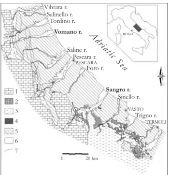
Fig. 1 – Location of the case studies and geolithological scheme. 1) Carbonate sequence (Upper Triassic-Miocene). 2) Varicoloured Clays (Upper Cretaceous-Oligocene). 3) Turbiditic deposits (Laga formation and Molise nappe, Miocene). 4) Evaporitic deposits (Upper Miocene). 5) Pelitic deposits of Abruzzo and Molise foredeep (Plio-Pleistocene). 6) Alluvial deposits (Holocene). 7) Main faults and thrusts in the Mesozoic-Cenozoic
and Miocene deposits.
- Ubicazione dei casi di studio e schema geolitologico. 1) Successione carbonatica (Triassico
superiore–Miocene). 2) Argille Varicolori (Cretaceo superiore-Oligocene). 3) Depositi tor-biditici (Formazione della Laga e coltre molisana, Miocene). 4) Depositi evaporitici (Miocene superiore). 5) Depositi pelitici dell’avanfossa abruzzese – molisana (Plio-Pleistocene). 6) Depositi alluvionali (Olocene). 7) Principali faglie e sovrascorrimenti nei
depositi meso-cenozoici e miocenici.
Adriatic Sea Vibrata r. Salinello r. Tordino r. Vomano r. Saline r. PESCARA Pescara r. Foro r. Sangro r. Sinello r. VASTO Trigno r. TERMOLI 1 2 3 4 5 6 7 0 20 km ROMA
Sangro alluvial valley (DESIDERIOet alii, 2007) was developed to estimate groundwater resources and river-aquifer exchanges, while a local scale nume-rical model was also developed for saline intru-sion phenomena analysis in coastal area, both applied for interpretation purposes (ANDERSON & WOESSNER, 1992) and simulation of different exploitation scenarios.
The Vomano valley aquifer, playing a key-role on water supply at both local and regional scale, has been previously analysed for definition of hydrogeological settings and groundwater dyna-mics (recharge, geometry, parameter distribution, surface water body interactions and fresh-salt water interface) by DESIDERIO et alii (2003), DESIDERIO& RUSI(2003), RUSIet alii (2004).
The optimisation of well fields pumping regimes and protection of water resource quality represent some major hot issues for a sustainable development; the application of groundwater modelling techniques has improved the know-ledge of hydrogeological framework, useful for problems analysis related to concentrated groundwater exploitations, as sea water intrusion, and impacts of anthropic activities.
2. – THE SANGRO ALLUVIAL VALLEY 2.1. – GEOLOGICAL SETTING
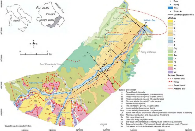
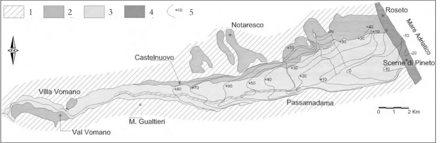
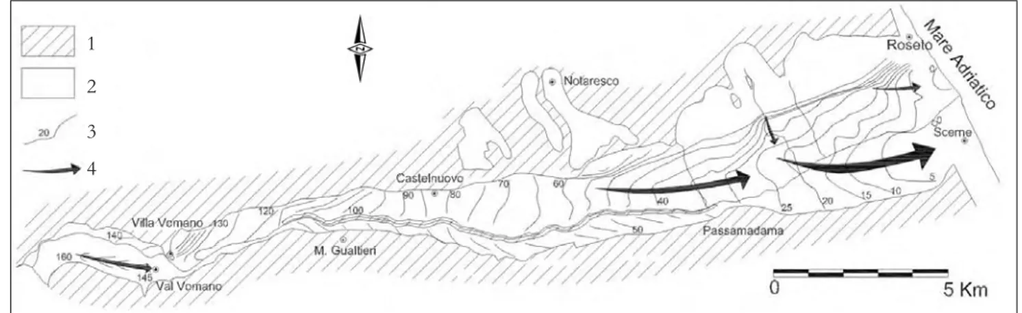
The lower Sangro valley (fig. 2) is located between the terrigenous alloctonous units of the molisan facies (SELLI, 1962; CATENACCI, 1974; PATACCAet alii, 1992) and plio-pleistocenic marine deposits of the Abruzzo-Molise foredeep (MOSTARDINI & MERLINI, 1986; GHISETTI & VEZZANI, 1996-97); these units, mainly clayey deposits, constitute the basement of the alluvial deposits (fig. 3) superimposed on top of the Aventino-Sangro gravity flow deposits (ENI -AGIP, 1972), upstream of the confluence with Aventino river, while overlay marine plio-plei-stocenic deposits downstream (CRESCENTI, 1971; CRESCENTI et alii, 1980). The plio-pleistocenic basement is mainly constituted by clays, sandy clays and marly clays, while arenaceous conglo-merates are predominant near the coastal areas; sometimes the arenaceous conglomerates vary to sandy silts and clayey silts that have typical facies of marine-coastal to fluvio-deltaic environments. The I, II and III order alluvial terraces are
con-Fig. 2 – Geologic map of the Sangro alluvial plain with boreholes locations; modified after DESIDERIOet alii,2007. - Carta geologica della pianura alluvionale del Fiume Sangro e ubicazione dei sondaggi geognostici.
stituted by gravelly sand deposits, sometimes slightly cemented, with silty-sandy-clayey lens and occasional brown-blackish paleosoils. The sandy matrix shows ferritazation signs more evident in relation to the deposits age. Sandy and gravelly deposits with silty-sands and clayey lens consti-tute the IV order alluvial terrace, which has been cut by Sangro river. Thalweg alluvial deposits are mainly formed of gravels and sands.
The alluvial deposits are located in corrispon-dence of a complicated mainly strike-slip faults system related to Volturno-Sangro tectonic linea-ment (DEMANGEOT, 1965; CASNEDI et alii, 1981; GHISETTI& VEZZANI, 1983).
The coastal areas are dominated by gravelly and sandy beach deposits and sandy fluvial deposits related to the latest flandrian marine ingression; huge debris deposits, related to weath-ering of plio-pleistocenic hills, lay on Sangro river right side.
2.2. - HYDROLOGY AND ANTHROPIC SETTING The hydrological balance was evaluated con-sidering data from 34 pluviometric and thermo-metric stations (SERVIZIO IDROGRAFICO E MA
-REOGRAFICO, 1955-1995) of the whole Sangro-Aventino hydrologic basin, considering a 40 years observation period; the network has been inte-grated also by 8 fictitious pluviometric stations.
Applying TURC(1961) and THORNTHWAITE& MATHER (1957) methodologies, the mean preci-pitation is about 1060÷1080 mm/year while the global surface runoff of about 560 ÷670 mm/year, with high spatial variations due to orography, distance from sea and provenience of humid currents. The pluviometric regime under-lines an Apennine sublittoral climate, with marine influences in coastal area; the minimum precipitation values occur in summer time and along coastal area, while the maximum ones occur in winter and spring months, especially in mountainous zones, when the temperature is also lower.
The Sangro alluvial plains is characterized by an enormous social and economic development that require a huge hydroelectric, irrigation, industrial and civil exploitation of superficial and groundwa-ter resources; the Sangro river flow regime is influ-enced by dams of Bomba, Casoli, Serranella and Sant’Angelo of Altino hydroelectric stations, with an average discharge to sea of about 30 m3/s. Fig. 3 - Schematic geolithological sections of the Sangro alluvial plain; modified after DESIDERIOet alii, 2007.
2.3. - HYDROGEOLOGY
Sangro aquifer geometry has been defined by surface geological and geomorphological surveys, photogeological multitemporal and multiscale analysis and bibliographical geognostic and geo-physical investigations (fig. 2). The aquifer is con-stituted by recent and ancient alluvial deposits characterized by high variable grain-size.
The thickness of the I, II and III order ter-races are between 2÷3 m up to 30 m, while the recent alluvial deposits thickness ranges from a few meters in the upstream and lateral plain areas up to 35÷40 m near the coastline (fig. 3). The upstream area is dominated by sandy-gravelly deposits, with only local thin sandy and silty-clayey deposits, while the central and downstream areas of the valley are dominated by gravelly-sandy deposits with clayey-silty lens on Sangro river left side, and silty-sandy and silty-clayey deposits, on the right side. The silty-clayey deposits on the alluvial succession top are rela-tively thick in the central valley, about 15 m, and near coastline, up to 20 m; topsoil, mainly
consti-tuted by organic silty clays, is about 1÷2 m thick. The aquifer is unconfined even if the silty-clayey lens often tend to configure as aquitards near coast-line and on Sangro river right side (DERISOet alii, 1994), a typical condition of many Abruzzo and Marche alluvial plains (NANNI, 1985; DESIDERIO et
alii, 1999), and only locally is multilayer. 2.4. - HYDRODYNAMICS
The Sangro valley piezometry and its temporal oscillations have been evaluated by seasonal sur-veys on over 160 wells.
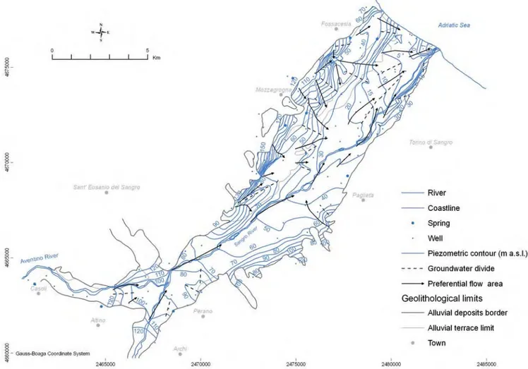
Groundwater flow is mainly influenced by paleo-rivers (fig. 4), from alluvial plain borders towards the main water body. Piezometry is dependent on basement morphology, amounts of seasonal recharge and withdrawals, thus the hydraulic aquifer-river exchanges tend to vary. The main drainage axis lays on Sangro river right side in central-upper alluvial plain, then moves to left side due to the presence of a groundwater divide, and converges again towards the river in coastal area. Large depression cones are related to heavy
with-Fig. 4 – Piezometric heads with preferential flow areas and groundwater devides (April 2000), on the basis of more than 160 wells and 10 springs; modified after DESIDERIOet alii, 2007.
drawals for irrigation purposes. Upper alluvial ter-races contribute to recharge of the preferential drainage axis in relation to surface and basement morphology, hydraulic conductivities, geometry and Plio-Pleistocene system contributions.
Hydraulic gradient is about 4÷5‰ near the recent and IV order terrace deposits and 20÷50‰ in other areas; it is locally higher due to aquifer thin-ning, hydraulic conductivity variations and local recharge conditions. Groundwater exchange occurs from alluvial terraces towards recent deposits due to sandy-silty overlying layers assuring hydraulic communication; hydraulic gradient increase in coastal area is related to silty-clayey deposits.
Piezometric oscillations are related to amount and distribution of effective recharge related to precipitations, hydrodynamic characteristics of alluvial and overlying deposits, infiltration from surface streams, irrigation and withdrawals. Annual water table oscillations vary from 0.3 up to 1.3 m, with maximum levels recorded in March-April and minimum ones in July-August; variations, after rainfall events, occur within 1÷2 months, due to medium and high hydraulic con-ductivities. The discharge period varies from 4 up to 5÷6 months, while recharge period varies from 4 up to 8 months.
Aquifer hydrodynamic properties (SCANDELLARI, 1970; CELICO, 1983; DE RISO et
alii, 1994; DESIDERIO et alii, 2007) depend on silt, silty-sandy and silty-clayey deposits distribution with an average hydraulic conductivity value less than 4 × 10⁻⁴ m/s. The gravelly-sandy deposits have hydraulic conductivity values varying from 1.8 × 10⁻⁴m/s up to 4.4 × 10⁻⁴m/s. Paleo-river conductivities are about 2 × 10⁻³m/s. The Sangro river has strong water exchange, variable through time, with its underlying aquifer. Locally relevant water quantities flow also from secondary valleys. Sangro aquifer water flux towards Adriatic sea is estimated of about 0.2÷0.3 m3/s (DESIDERIO et
alii, 2007).
Some springs, monitored between October 2000 and November 2001, are located at the con-tact between terraced alluvial deposits and low conductivity gravity flow and Plio-Pleistocene deposits. Spring discharges, generally modest and concentrated during winter, are normally less than 1 l/s with short time responses of 1÷2 months or even lower, days, to rainfall events; discharge regimes are extremely variable, Rv > 100% (MEINZER, 1923), related to limited recharge zones and high hydraulic conductivities.
The wells are used mostly for irrigation, some-times for civil uses; pumping rates, varying from 1 ÷5 l/s up to 10÷15 l/s, are discontinuous in time and applied principally during dry seasons.
2.5. – HYDROCHEMISTRY
Specific electrical conductivities highlight spa-tial and temporal changes in Sangro plain varying from about 400 to more than 2000 µS/cm. The lower values are found in the medium to higher valley in correspondence of preferential flow axis and I, II and III alluvial terraces. Dilution effects cause lowering of specific conductivity values in periods of higher aquifer recharge; in the lower valley there are locally opposite trends due to dis-solution of substances in unsaturated zone.
Values higher than 2000 µS/cm, also more than 7000 µS/cm, are detected in coastal area due to sea water intrusion related to localized with-drawals; values between 3000 and 11400 µS/cm were detected in the medium-lower valley, all the way to the river outlet; these anomalies are rela-ted to upward migration of deep mineralized waters (DESIDERIO & RUSI, 2004). Groundwater temperatures are influenced by atmospheric varia-tions in lower valley due to a shallow water table. Temperature ranges from 12 up to 18 °C in win-ter and 15 up to 28 °C in summer. Groundwawin-ter temperatures along preferential drainage axis are lower than those of the next recharge areas due to different circulation times.
Spring waters monitoring has shown average specific conductivity values from 695 up to 1624 µS/cm. Average temperatures, from 13.9 up to 16.6°C, are essentially related to atmospheric tem-perature varations.
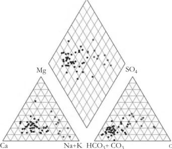
The dominant hydrochemical facies within Sangro aquifer is bicarbonate-calcium facies (fig. 5). Some waters have bicarbonate-alkaline and sul-phate-chloride-earthy alkaline facies; the later is related to mixing with deep and marine
mineral-Fig. 5 – Piper’s diagram of the Sangro plain groundwaters. – Diagramma di Piper relativo alle acque della piana del Sangro.
Mg SO4
ized waters. Bicarbonate-calcium waters are mainly distributed in the higher valley and along river thal-weg, where appennine origin waters prevail. 2.5.1. - Deep flow mineralization
Mineralised waters, typical of areas with high specific electrical conductivity, normally have sul-phate-chlorine-alkaline-earthy alkaline facies, as chloride-sodium and sulphate-sodium. These anomalies are related to saline intrusions (DESIDERIO& RUSI, 2003), due to upward migra-tion of deep mineralized waters from Abruzzo-Molise foredeep, and dissolution of evaporitic deposits within the depositional sequence (DESIDERIO& RUSI, 2004).
Mineralization phenomena are proved on the basis of the 18O - 2H isotopic ratio and rSO
4
2-/rCl- and rMg2-/rCa2- characteristic ion ratios; other typical ion ratios like rK+/rNa+, rSr2+ /rBr-, rBr-/rCl- and rLi+/rSr2+ are also evidence of these phenomena. Mineralized waters along tec-tonic lineaments on Sangro right side have higher rSO42-/rCl- and rMg2-/rCa2- ion ratios, while water, affected by saline intrusions have lower va-lues than average aquifer deposits.
The unconfined aquifer is recharged mainly by fluvial waters from calcium-bicarbonate facies of Apennine origin, as confirmed by electrical con-ductivity and groundwater temperature values. River recharge is further testified by groundwater chemistry; close to riverbed the waters present calcium-bicarbonate facies with low saline con-tent. Waters of this type are also found along paleo-river draining Vomano river and its primary tributaries. The high terraces, on the other hand, are recharged mostly by rainwater. Deep flow mineralization is due to Pliocene or Messinian origin waters (NANNI& VIVALDA, 1998, 1999 and 1999a; DESIDERIO & RUSI, 2004, DESIDERIO et
alii, 2007b), rising along fault-associated fracture zones in plio-pleistocenic basement deposits up to overlaying unconfined aquifer. The mixing of sodium-chloride and calcium-sulfate facies Pliocene and Messinian mineralised waters with the calcium-bicarbonate waters of the aquifer lead to different hydrochemical facies in emerging zones. Recharge by the Messinian and Pliocene waters is very slight and mainly influences the groundwater chemistry, causing enrichment in Cl-, Na+, Mg++ and SO
4— of calcium-bicarbonate
waters originating from fluvial recharge (fig. 5). 2.5.2. – Sea-water intrusion
Piezometric levels show minimum values, sometimes negative, on Sangro river left side near
coastline, related to withdrawals for irrigation purposes during summer (10÷15 l/s). Local drainage from river occurs where gravelly and sandy alluvial deposits related to paleo-rivers are present. There is a vast recharge area to the western side, which partially compensates summer with-drawals.
The multiparametric profiles conducted on monitoring wells located in the lower valley (fig. 6) show a three dimensional variability of groundwa-ter chemical-physical (T, χ, Eh) paramegroundwa-ters (fig. 7). Temperature measurements ranged from 14.4 up to 26.8 °C in July 2005. Vertical temperature changes are generally modest; negative trends were recorded within upper aquifer related to influence of surface temperatures and subsurface hydrodynamics.
Electrical conductivity values change more than 8000 μS/cm along the vertical. This para-meter often increases at just 1÷2 m below the sur-face in coastal areas. In other wells, even though water exploitations occur (discontinuous and va-riable, between 1 and 5 l/s), chemical-physical parameters tend to be constant along the vertical, due to greater hydraulic conductivities. Specific electrical conductivity values exceed 2000 μS/cm near the left side river outlet, where a negative piezometry of more than -1 m a.s.l. exists. These irrigation wells tend to mobilise higher salinity waters. Values larger than 5000 μS/cm in vertical direction were recorded in wells located at about 1 km from the coastline where no exploitations occur, due to upward migration of deep water from the plio-pleistocenic deposits (DESIDERIO& RUSI, 2004).
The Eh parameter tends to decrease with depth, from 2÷3 m from the water table, then sta-bilizes on negative values. The reducing condi-tions are related to circulation within deposits with a silt-clay fraction, sometimes peaty, charac-terized by low hydraulic conductivities. A possible influence is related with mobilization of deep waters with negative Eh values.
2.6. - MODEL DESIGN, CALIBRATION AND SENSI -TIVITY ANALYSIS
Scope of Sangro valley groundwater numerical modelling, carried out by the finite-element FEFLOW code (DHI-WASY, 2009), was the quan-titative assessment of underground water fluxes and saline intrusion phenomena. The conceptual model is supported by soft ideas (NYKRAVESH et
alii, 2003; AMINZADEH, 2004). This method enhances peculiar aquifer characteristics. Integrated use of both hard data and soft ideas are fundamental for defining aquifer geometries,
hydrodynamic parameters, effective recharge and issues related with salt water intrusion phenomena. Variability of hydrogeological and hydrogeochemical parameters and boundary conditions was analysed respect to simulation of conservative scenarios.
A regional numerical model was built to assess groundwater resources, river-aquifer water ex-change, the influence of palaeo-rivers and fluxes from alluvial terraces; a local model was so used to estimate groundwater fluxes to sea and saline intrusion phenomena, with higher resolution details in coastal area.
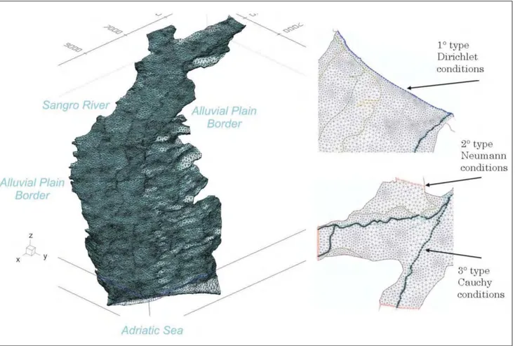
The regional 3D mesh (fig. 8), developed over an area of about 82.67 × 10⁶m2, has 118380 ele-ments and 76360 nodes over 5 vertical layers. The dimensions of the triangular-based prismatic ele-ments gradually vary from 120÷130 to 25÷30 m near wells. Steady-state conditions were used du-ring simulations with free and movable conditions (DIERSCH & MICHELS, 1996; DIERSCH, 1998). Geometry settings was defined on the basis of 55 geolithological sections, while hydrogeological parameters were assigned on the basis of available hydrodynamic data.
The hydraulic conductivities and the recharges were distributed on a zone basis (ANDERSON & WOESSNER, 1992; PINDER, 2002; RUSHTON, 2005). Hydraulic conductivities of 8 × 10⁻⁴ m/s were considered reasonable for the IV order terraces and recent deposits. Hydraulic gradients and bore-hole logs justify hydraulic conductivity values of about 2.5 × 10⁻³m/s in areas of preferential flow, with analogies to other Abruzzo coastal alluvial valleys (CELICO 1983; DESIDERIO et alii, 2007a). Silty-sandy drift deposits have an hydraulic con-ductivity of 4 × 10⁻⁴ m/s (SCANDELLARI, 1970). The regional model is not very reliable in relation to the I, II and III order terraces due to scarce availability of data. Hydraulic conductivities how-ever vary from 7 × 10⁻⁴up to 2 × 10⁻³m/s. The hydrodynamic parameters, evaluated through numerical modelling, produce plausible piezome-tric configurations.
Effective recharge was differentiated respect to estimated rainfall recharge and surface litholo-gies; locally recharge components are also related to irrigation, especially during dry seasons. Sensitivity analysis proves that modest parameter
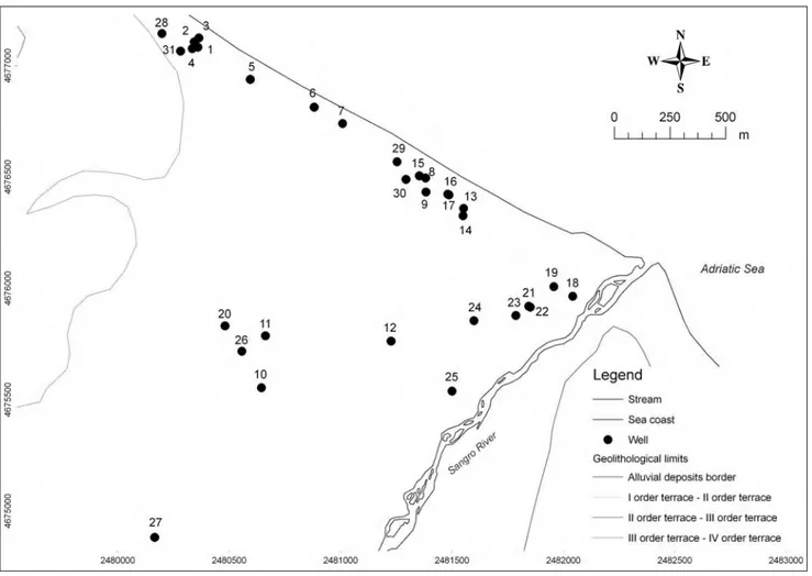
Fig. 6 - Wells used for multiparametric logs. - Pozzi nei quali sono stati eseguiti i profili multiparametrici.
Fig. 7 – Multiparametric logs of a coastal well (at left, n. 7 in figure 6) and a well with mineralized waters (at right, n. 12 in figure 6). – Profili multiparametrici di un pozzo costiero (a sinistra, n. 7 in figura 6) e di un pozzo con acque mineralizzate (a destra, n. 12 in figura 6).
Fig. 8 - 3D mesh and boundary conditions of the Sangro plain regional numerical model (exaggeration factor 10:1); mod. from DESIDERIOet alii, 2007. - Mesh 3D e condizioni al contorno del modello numerico, a scala regionale, della piana del Sangro (esagerazione verticale 10:1).
changes have a great influence in hydraulic heads distribution.
Boundary conditions were assigned conside-ring hydrogeological characteristics and model domain extends up to Plio-Pleistocene hills, while the basement is considered impermeable. In the higher alluvial plain border and in correspon-dence of secondary valleys, fixed flux conditions were applied on the basis of estimated ground-water discharge. Transfer type conditions (DIERSCH, 2002) were applied along Sangro river and constant hydraulic heads, 0 m a.s.l., were applied along coastline.
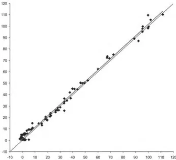
Averages of piezometric heads, from monito-ring program, were used for different observation points during calibration phase; the dominance of positive residual values is justified by the simula-tion of condisimula-tions without exploitasimula-tions (fig. 9).
2.6.1. - Simulation of sea-water intrusion
Conceptual and numerical analysis of Sangro valley aquifers highlights typical problems in groundwater withdrawals and management in coastal areas due to sea-water intrusion and sali-nization process.
The local numerical models simulates density-dependent flow and transport conditions in the aquifer thus taking into account differences of saline concentrations. The mesh of Sangro local model, which extends over an area of about 5.93 × 10⁶ m2, is constituted by 211680 cells and 116130 nodes over 14 layers. Triangular-based
prismatic elements have orthogonal projections that vary in dimensions from 70 m in the western coastal area to 30 m in areas near the coast and finally 10÷15 m in the proximity of the exploita-tion wells.
The topmost 7 layers identify the silty-sandy superficial deposits in the western area, and the sandy gravels and silty-clayey lenses in the coastal areas. All remaining layers represent the sandy-gravelly deposits. The distribution of the hydro-geological properties and the effective recharge is derived from the regional model. Constant fluxes in the western area and equivalent hydraulic heads (DIERSCH & KOLDITZ, 1998; DIERSCH, 2002), assuming a sea water density of 1025 g/l for an average salt concentration of 35 g/l, were assumed as boundary conditions. Constraints were applied on the concentrations of incoming and outgoing water fluxes.
The local model was used to simulate scena-rios, starting from undisturbed conditions, using different exploitation schemes. The scenario simu-lating undisturbed conditions was obtained from transient conditions over a long period of 100000 years. The other simulations with ongoing exploitations were run with variable periods going from 30 up to 100 years. Distribution of hydraulic heads and concentrations were calculated at both the end of the time interval and during transient conditions so as to simulate saline intrusion phe-nomena.
The first scenario considered typical summer exploitations related to irrigation purposes (fig. 10). Variable exploitation rates vary from 0.1 up to 0.2 m3/s through several irrigation wells, up to 15÷20 l/s per well. In some stations the exploita-tion is lower of about 2÷5 l/s and occurs over a short period of few hours. Saline intrusion phe-nomena occur in these conditions mainly in the areas on the left side of the river near coast. Strong saline intrusion evidences occur in some wells located at short distances from the coast line. These wells are sometimes located on low hydraulic conductivity alluvial deposits. This sce-nario maximizes the stress conditions of the sy-stem due to the fact that the exploitations are not constant on time and superficial recharge is pre-sent due to irrigation.
A second scenario with a limited exploitation of only 1 l/s per well, produces reduced saline intrusion phenomena near those wells that are very close to the coast-line where only local high concentrations are recorded.
Other scenarios have been simulated with exploitation rates varying between 0.12 and 0.3 m3/s on wells located 2÷4 km from the coast-line and others with wells that are in proximity of the
Fig. 9 - Measured vs. simulated value of hydraulic head in the calibration graph of the regional numerical model of Sangro alluvial plain. - Confronto tra valori misurati e valori simulati di carico idraulico nel grafico di
river outlet. Intense agricultural schemes are in place in these areas and the absence or reduced presence of superficial irrigation systems increa-ses the need for groundwater exploitations for irrigation. The pumping rates often accelerate the saline intrusion phenomena.
Hydraulic heads tend to reach equilibrium usu-ally within 2÷3 years, while concentrations tend to have significant variability for periods that range from 15 to 25 years.
The different scenarios confirm saline intrusion phenomena due to exploitation in areas near to the river outlet, especially when these are constant through time. Critical conditions of variable con-centrations due to strong decrease of piezometric levels are present even after long periods thus proving the persistence of salt water intrusions.
3. – THE VOMANO ALLUVIAL VALLEY 3.1. – GEOLOGICAL SETTING
The ancient and recent alluvial deposits of the Vomano river plain (fig. 11) consist of gravel, sandy-gravel and gravelly-sand bodies. Above these, in the middle-low part of the plain, clayey-muddy-sandy and clayey-muddy-sandy-clayey deposits are present, varying in thickness from few metres up to 20 m near the coastal belt. Sandy-gravelly deposits crop out in the upper part of the river valley. The substrate beneath the alluvial deposits mainly comprises lithotypes such as the marly clays and clayey marls of the Cellino Formations and Argille Grigio Azzurre (CRESCENTI, 1971; CRESCENTI et alii, 1980; CASNEDI et alii, 1981; Fig. 10 - Salt water intrusion phenomena near the coastal area and flow lines, typical summer exploitations scenario (total salinity in mg/l; exaggeration
factor 10:1); after DESIDERIOet alii, 2007.
- Fenomeni di intrusione salina nella zona costiera e linee di flusso, relativamente allo scenario tipico estivo (salinità totale in mg/l; esagerazione verticale 10:1); da DESIDERIOet alii, 2007.
Adriatic Sea
VEZZANI& GHISETTI, 1998). In the upper part of the plain, however, the substrate is made up of more permeable lithotypes: these are arenaceous and marly deposits originating from the Laga Formation and the Messinian deposits. The clay basement elevation contours were interpolated after 9 geoelectric prospecting profiles, in the well fields area, including more than 120 Vertical Electrical Soundings (CASSA PER IL MEZZO -GIORNO, 1971; CELICO, 1983) and 18 borehole logs (fig. 12).
The top of the substrate of the alluvial deposits is characterised by the presence of a palaeo-thal-weg, shifted some hundreds of metres north or south in relation to the present-day riverbed. 3.2. - HYDROLOGY AND WELL FIELDS
The hydrological balance was evaluated using data from pluviometric and thermometric sta-tions (SERVIZIO IDROGRAFICO E MAREOGRAFICO, 1955-1995). An average infiltration rate of about 110 mm/yr was estimated by THORNTHWAITE & MATHER(1957) and TURC (1961) methodologies, considering a 30 years observation period (1965-1995). The pluviometric regime underlines an Apennine sublittoral climate, with marine influ-ences; the minimum precipitation values are regi-stered in summer time, while the maximum ones occur in winter and spring months, while the tem-perature has an opposite trend. The water balance was calculated using more than 30 pluvio-termo-metric stations to evaluate the global surface runoff; the superficial hydrographic network is very limited due to high hydraulic conductivity of shallow alluvial deposits and soils so that most of meteoric waters recharges the aquifer, after sati-sfaction of the soil deficit.
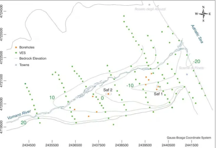
In the eastern part of the Vomano valley, two well fields, Saf 1 and Saf 2 of ACA S.p.A. (a local water agency) are located, not far away from the coastline. The two well fields are located on a highly conductive palaeo-river, as resulted from geophysical prospecting and boreholes. Current overall withdrawal is in the range of 200÷470 l/s, depending upon season, with the average of about 270 l/s. The pumping regimes consist in about 150÷250 l/s for Saf 1 and, when the water request is higher or in emergency conditions as in drought periods, in about 100 l/s for Saf 2, with hydraulic heads up to 3÷4 m below mean sea level in Saf 1 area located near to coastline.
3.3. - HYDROGEOLOGY
As emerging from previous hydrogeological studies (CASSA PER IL MEZZOGIORNO, 1971; CELICO, 1983; DESIDERIO et alii, 2003), the Vomano valley is characterized by a single phrea-tic aquifer system, with minor semi-confined la-yers, overlying an impermeable clay basement (fig. 13). Major hydrogeological features include Vomano river and some, possibly highly conduc-tive, paleo-rivers related to geomorphological and tectonic history of most alluvial valleys of Abruzzo and Marche regions.
The alluvial deposits overlay an impermeable clay basement, with thickness varying from few meters in the proximity of its outcrops, up to about 28 m along the main paleo-river.
The alluvial deposits constitute the III and IV order terraces of Vomano plain; the aquifer sy-stem consists mostly of gravel, sandy-gravel and gravelly-sand bodies. In the middle-low plain, clayey-muddy-sandy and muddy-sandy-clayey deposits with much lower hydraulic conductivity
Fig. 11 – Schematic geologic map of the Vomano alluvial plain. 1) Pelitic-arenaceous deposits (Pliocene-Pleistocene). 2) Alluvial terrace (I and II order). 3) Alluvial terrace (III and IV order). 4) Coastal deposits. 5) Substratum morphology (contour lines in m a.s.l.); modified after DESIDERIOet alii, 2003. – Schema geologico della piana alluvionale del Vomano. 1) Depositi pelitico-arenacei (Pliocene-Pleistocene). 2) Alluvioni terrazzate (I e II ordine). 3) Alluvioni terrazzate (III e IV
ordine). 4) Depositi costieri. 5) Morfologia del substrato (isolinee in m s.l.m.).
4 3
2
values, are responsible for local semi-confined conditions. The silty and clayey soil, is 1÷2 m thick.
The palaeo-river, with a northern deviation close to the coastline, is made by gravelly and sandy deposits, while in the adjacent zones silty matrix gravelly-sands are present; at the valley border sandy silts are prevalent.
The Vomano river thalweg, in the study area, is made by recent alluvial gravelly and locally sandy deposits; hydraulic continuity with aquifers occurs with a prevalent surface water contribution respect to direct precipitation recharge.
3.4. – HYDROCHEMISTRY
The unconfined aquifer is recharged mainly by fluvial waters from calcium-bicarbonate facies of Apennine origin, as confirmed by the values of electrical conductivity and groundwater tempera-ture (DESIDERIOet alii, 2003. River recharge is fur-ther testified by the chemistry of the groundwa-ter: close to the river bed the waters present cal-cium-bicarbonate facies with low saline content. Waters of this type are also found near the main
drainage axes, which drain the waters of the Vomano river and its primary tributaries through palaeo-thalwegs.
The aquifer is also recharged by deep waters of Pliocene or Messinian origin (DESIDERIOet alii, 2003, 2004). These waters, rising along fault-asso-ciated fracture zones in the Plio-Pleistocene sub-strate deposits, are carried to the base of the unconfined aquifer. The mixing of sodium-chlo-ride and calcium-sulfate facies Pliocene and Messinian mineralised waters with the calcium-bicarbonate waters of the aquifer lead to different hydrochemical facies in the aquifer areas close to the zones where the mineralised waters emerge.
Recharge by the Messinian and Pliocene waters is very slight and mainly influences the chemistry of underground waters, causing enrich-ment in Cl-, Na+, Mg++and SO
4—of the
calcium-bicarbonate waters originating from fluvial recharge (fig. 14).
3.5. - HYDRODYNAMICS
Vomano valley groundwater circulation is closely dependent on palaeo-rivers.
Fig. 12 - Bedrock elevation map with location of VES and boreholes in the lower Vomano alluvial plain. - Carta del substrato con ubicazione dei SEV e dei sondaggi geognostici nella piana alluvionale del Vomano.
Piezometry, based on seasonal monitoring of 150 wells during 2000, highlights (fig. 15): -groundwater heads generally interesting gravels and gravelly sands under overlaying low conduc-tivity silt deposits; - a water circulation depending on basement morphology related to palaeo-rivers; - left side river drainage in medium and lower val-ley for riverbed gravels and sands; - aquifer drainage into river where flowing directly on basement deposits; - groundwater flow to recent III and IV order terraces from ancient I and II order terraces aquifers, with a prevalent recharge by precipitations.
Aquifer recharge is related to direct precipita-tion and Apennine contribuprecipita-tions in the higher valley; differently in the lower valley it is influe-nced by river inflows especially along palaeo-rivers, direct precipitations, superficial runoff on hillsides and, during dry seasons, irrigation com-ponents.
Several pumping tests of different duration and operative plan were executed in Saf 1 and Saf 2 well fields to evaluate hydrodynamic parameters. The pumping tests were executed with constant flow rates considering the installed pumps typo-logy and aqueduct system (RUSIet alii, 2004). Fig. 13 - A 3D overview of the ground above) and bedrock (below) surfaces (exaggeration factor, 5:1); after RUSIet alii2004.
- Vista 3D della superficie topografica (in alto) e del basamento impermeabile (in basso; esagerazione verticale, 5:1).
Ground Elevation (m a.s.l.)
Vomaro River Saf 2 Well Field Saf 1 Well Field Scerne di Pineto Adriatic Sea
Some pumping tests were executed on single wells in transient and steady-state conditions for short and long periods (from 3 up to 76 h), moni-toring drawdowns in surrounding wells (fig. 16).
Equilibrium was reached in Saf 1 well field about 2 h after the beginning of pumping at the highest possible flow rate allowed by the installed pump (60 l/s). The high aquifer transmissivity involves not only piezometric surface stabilization but even water levels rising in testing and sur-rounding monitoring wells; these pumping tests were so worked out only considering the steady-state condition (DUPUIT, 1863).
Hydraulic conductivity values range from 2.0× 10⁻³m/s to 3.1×10⁻³m/s, and average transmis-sivity is 4.1×10⁻²m2/s, considering an aquifer thick-ness of 18 m.
It was possible for Saf 2 well field pumping
tests also the transient condition (THEIS, 1935) because the transmissivity is limited due to a smaller aquifer thickness; hydraulic conductivity values range from 1.5×10⁻³m/s up to 2.7×10⁻³m/s, with an average transmissivity of about 2×10⁻²m2/s, considering an aquifer thickness of 9.5 m.
Other pumping tests were executed in maxi-mum stress condition allowed by pumping stations (approximately 50 l/s for each well), for about 24 h, to evaluate the hydrodynamic response under overexploitation. The influence of the well fields, in these conditions, was limited in the surrounding areas already at distances of a few hundreds of meters; definitely the influence is limited on short period (one or two days); in any case it is very influ-ential on long periods (some days). Hydraulic con-ductivity values, based on long time pumping tests and geophysical evidence, are generally in order of 2 ×10⁻⁴m/s up to about 2.5 × 10⁻³ m/s in corre-spondence of the palaeo-river.
3.6. - MODEL DESIGN AND NUMERICAL ANALYSIS A finite-difference groundwater flow model was developed for lower Vomano aquifer by using MODFLOW 2000 numerical code, in steady-state and transient conditions for optimization of well fields pumping regime.
The domain was discretised using a regularly spaced grid with 48750 cells, with cell size of 20 m; applying Telescopic Mesh Refinement (TMR) approach (WARDet alii, 1987), two site models were implemented around Saf 1 and Saf 2 well fields, with irregularly spaced grids, characterized by a denser refinement near pumping wells (fig. 17).
A constant head boundary of 0 m a.s.l. was used for the coastal zone; no-flow boundaries were specified near southern impermeable hills where the water recharge looks like to be very
Fig. 14 - Piper’s diagram of the Vomano plain groundwaters. - Diagramma di Piper relativo alle acque della piana del Vomano.
Fig. 15 - Piezometric map of the Vomano alluvial plain. 1) Pelitic-arenaceous bedrock. 2) Alluvial terrace (I - IV order). 3) Piezometric contour (m a.s.l.). 4) Preferenzial flow area; modified after DESIDERIOet alii, 2003.
- Carta piezometrica della piana alluvionale del Vomano. 1) Substrato pelitico-arenaceo. 2) Alluvioni terrazzate (I - IV ordine). 3) Isopiezometriche (m s.l.m.). 4) Zone e direzioni di
drenaggio sotteraneo. Mg SO4 Ca Na+K HCO3+ CO3 Cl 1 2 3 4
Fig. 16 - Location of Saf 1 and Saf 2 wells used for pumping test. - Ubicazione dei pozzi nei campi Saf 1 e Saf 2 sottoposti a prove di emungimento.
Fig. 17 - Detail of the irregularly spaced grid of the Saf 2 well field local model of the Vomano plain. - Dettaglio della griglia a spaziatura irregolare del modello numerico del Campo Pozzi Saf 2 della piana del Vomano.
small due to the presence of a very thin and low permeable aquifer and lack of a relevant superfi-cial hydrographic network; Vomano river was simulated using variable flow boundaries (Cauchy conditions), and infiltration was assumed stant in time. Different pumping rates were con-sidered, both for steady-state and transient cali-brations and simulations.
The model domain was divided in zones with different hydrogeological properties based on the interpretation of well fields pumping tests (fig. 18), geophysical prospecting outcomes and bore-hole logs. The specific focus was to capture the hydrogeological characteristics of the depositio-nal environment. The reference values, obtained by calibration with the best fitting between the calculated and observed drawdown curves, are the most reasonable because they are in accordance with the hydrogeological parameters values evalu-ated through the pumping tests with DUPUIT (1863) and THEIS (1935) methods and the litera-ture reference values (CASSA PER IL MEZZO -GIORNO, 1971; RUSIet alii, 2004).
The seasonal measurements of the piezome-tric heads were executed in 150 wells on the whole Vomano plain to observe the piezometric oscillations. The highest oscillations, some meters, were observed in the study area due to water exploitation for drinking, irrigation and industrial purposes, while in other parts of the
valley the oscillations were smaller, lower than 1 m. Initially the model was calibrated in steady-state conditions using the mean observed water levels and considering the average wells exploita-tion in the area.
Afterwards the model was calibrated using the drawdown curves both in the case of the single well tests and the overexploitation conditions. The model calculates an adequate piezometric heads distribution for the different stress condi-tions, even if there are some differences between the computed and observed heads mainly due to uncertainty in parameter values distribution, par-ticularly in the areas located at a certain distance from the well fields, where no pumping tests were available, and in the initial heads distribution. The residuals are minimum at the end of pumping tests for both well fields.
3.6.1. - Well fields management
Definitely the calibrated flow model is reaso-nable to investigate some major issues, concer-ning the optimisation of the existing well fields pumping regimes as well as the establishment of the wellhead protection zones.
The model supported an overall analysis of the hydrogeological system, highlighting the key-role of the major palaeo-river in controlling aquifer behaviour, as emerging from fundamental
Fig. 18 - The location of the hydrogeological zones with the numerical model domains; from RUSIet alii,2004. - Localizzazione delle differenti zone idrogeologiche con individuazione dei domini dei modelli numerici implementati.
components in the local hydrogeological balance, flow paths and velocity fields. The attention was also focused on Vomano river recharging role. At first, the piezometric heads distribution in steady-state conditions and without exploitations was computed (fig. 19), considering the reference parameter values. In this condition the aquifer drains the Vomano river superficial waters in the western area near the Saf 2 well field, while the river drains the aquifer waters along the north area near the Saf 1 well field. The water circula-tion is mainly influenced by high conductivity palaeo-river, impermeable bedrock geometry and alluvial deposits hydraulic properties as demon-strated by the computed velocity field. The water
budget results were computed using the ZONEB-UDGET code (HARBAUGH, 1990), so it was pos-sible to evaluate the river-aquifer water exchanges in different hydrogeological zones, and to esti-mate the groundwater flow to the Adriatic Sea.
Afterwards the calibrated model was used to simulate different exploitation scenarios, both in steady-state and transient conditions (fig. 19). The sustainable pumping rates were established con-sidering the steady-state conditions, while the periods of overexploitation were determined in transient conditions, assuming respectively the overall withdrawals of 450 l/s and 250 l/s for Saf 1 and Saf 2 well fields, with a pumping rate of 50 l/s for each well.
Fig. 19 - Simulated piezometric heads in steady-state condition, without withdrawals (above) and considering the mean withdrawals (below) from the eastern Vomano pumping wells.
- Distribuzione dei carichi piezometrici della zona orientale della Valle del Vomano simulati in condizioni stazionarie, senza emungimenti (in alto) e con emungimenti medi dai pozzi
The sustainable pumping regime for the Saf 1 well field is about 150 l/s, due to high aquifer transmissivity (about 4.1×10⁻² m2/s), to be applied alternatively to three wells, maintaining a flow rate of about 50 l/s from each well. The overexploitation of 450 l/s can be supported by the aquifer for a time of about 15 days. In any case it is preferable not to apply overexploitation pumping regime because it can cause salt water intrusion.
The Saf 2 well field can support an overall exploitation of about 100 l/s in steady-state con-dition, while the overexploitation of 250 l/s can be applied only for short periods (about 5 days), afterwards dry conditions occur in wells with high piezometric drawdown in the aquifer system.
The area is characterized by the presence of industrial plants, agriculture and quarry activities. Preliminary estimate of the wellhead protection areas were made applying the MODPATH parti-cle-tracking code (POLLOCK, 1989). The flow pathlines were computed for scenarios in sug-gested steady-state conditions for Saf 1 (150 l/s) and Saf 2 (100 l/s) well fields and the wellhead protection areas defined in a conservative way, considering the advective component (fig. 20).
The computed heads and flow pathlines clear-ly show the water contribution from the river. 3.6.2. - Simulation of sea-water intrusion
Salinization problems related to sea-water intrusion in Vomano coastal plain, potentially due to Saf 1 and Saf 2 well fields, have been numeri-cally analyzed with finite-element 3D density-dependent FEFLOW code. Model domain is
extended from Vomano river up to Plio-Pleistocene very low conductivity hills; the mesh is formed by 251770 elements and 141229 nodes over 10 vertical layers and is refined near well fields, for numerical efficiency and stability, with triangular-based prismatic elements gradually varying from about 50 to less than 1 m near wells. Boundary conditions are defined hydraulic heads along Vomano river and coastline, considering here a water density of 1025 g/l. After a calibra-tion tuning, the density-dependent model (CRESTAZ et alii, 2007) confirmed the previous numerical results yet highlighting: - high pumping rates for short periods do not induce sea water intrusion related to limited times and high piezo-metric heads between well fields and coastline due to Vomano river drainage; - overall withdrawals of about 250 l/s from Saf 1 and Saf 2 for a long period induce groundwater salinization along palaeo-river up to lower and principal well fields in about 8÷10 years (fig. 21).
Conceptual and density-dependent numerical analysis highlights the quantitative and qualitative sustainability of withdrawals on short and long periods, that contribute to avoid environmental and socio-economic damage.
4. - CONCLUSIONS
Groundwater resources of Sangro and Vomano rivers alluvial plain have been analyzed through flow and transport numerical simulations with MODFLOW and FEFLOW codes, in densi-ty-dependent conditions. The conceptual model has been based on geological, geomorphological,
Fig. 20 - Flow pathlines with markers every 30 days. Left: the Saf 2 well field area, considering the simulated steady-state condition with an exploitation of 100 l/s. Right: the Saf 1 well field with an exploitation of 150 l/s.
- Linee di flusso con markers ogni 30 giorni. A sinistra: campo pozzi Saf 2, scenario in stato stazionario, con un’estrazione idrica complessiva di 100 l/s. A destra: campo pozzi Saf
geognostic, geophysical, hydraulic, hydrogeologi-cal and chemihydrogeologi-cal data and interpretations.
The alluvial valleys, mainly constituted of both ancient and recent terraced alluvial deposits, are constituted by unconfined aquifers, even if semi-confined conditions are locally reached due to silty-clay lenses. Groundwater flow is strongly influenced by palaeo-rivers, while the influence of higher order terraces is generally modest. The dominant hydrochemical facies is calcium-bicar-bonate up to sulphuric-chloride-alkaline to sodi-um-chloride and sodium-sulphuric facies related to deep up flowing of mineralized waters.
Quantitative assessment of water resources has been possible through numerical modeling in relation to aquifer-river exchanges, influence of palaeo-rivers and water discharges coming from higher order terraces.
Salt-water intrusion phenomena in coastal areas of Sangro aquifer are related to withdrawals for civil and irrigation purposes; vertical chemical trends are evident due to variations in hydrody-namic conditions with depth and mixing with mineralized waters. Simulation results highlight that saline intrusion phenomena can be limited when exploitations are not concentrated during summer and a better spatial configuration of wells is adopted.
The Vomano well field sustainable pumping regimes and wellhead protection areas were defined both in steady-state and transient condi-tions. The simulated different exploitation scenar-ios highlight that maximum acceptable exploita-tion for Saf 1 and Saf 2 well fields is respectively in the order of 150 l/s and 100 l/s, under steady-state conditions, while a pumping regime of 50
Fig. 21 - Salt water intrusion phenomena near the coastal area and flow lines in the Vomano plain, scenario with withdrawals of about 250 l/s from Saf 1 and Saf 2 well fields for a long period (total salinity in mg/l; exaggeration factor 10:1).
- Fenomeni di intrusione salina nella zona costiera e linee di flusso nella piana del Vomano, relativamente allo scenario con emungimenti di 250 l/s per lungo periodo (salinità totale
l/s for each well can be supported, in transient conditions, by Saf 1 and Saf 2, respectively, for about 15 and 5 days.
The model simulated in an adequate way the aquifer behaviour so it provides a reference hydrogeological framework for evaluation of the aquifer capacities and of the superficial water contributions. It was also useful for water quality protection, through the delineation of flow path-lines in different exploitation conditions.
Numerical analysis highlights the risk of sea-water intrusion if concentrated withdrawals occur near coastline, particularly during higher water request and smaller aquifer recharge periods.
Geolithological and hydrogeological data of the unsatured zone and river flow measurements could be useful for calibration refining; moreover this research underlines the necessity of a conti-nuous monitoring network of groundwater with-drawals and hydraulic levels for predictive pur-poses.
Acknowledgements
The authors are grateful to the two anonymous reviewers for their appreciated and constructive comments.
REFERENCES
AMINZADEHF. (2004) - Soft computing for qualitative and
quan-titative seismic object and reservoir property prediction (Part 1-3).
EAGE, First Break, 22 (March, April and June 2004). ANDERSON M.P. & WOESSNER W.W. (1992) - Applied
Groundwater Modeling: Simulation of Flow and Advective Transport. Academic Press Inc., San Diego, CA, USA. ANSELIN L. (2004) - GeoDa 0.9.5-I Release Notes, Spatial
Analysis Laboratory and Center for Spatially Integrated Social Science (CSISS), Department of Agricultural and Consumer Economics, University of Illinois, Urbana-Champaign.
CASNEDIR., CRESCENTIU., D’AMATOC., MOSTARDINIF. & ROSSIU. (1981) - Il Plio-Pleistocene del sottosuolo molisano. Geologica Romana, 20, 1-42.
CASSA PER ILMEZZOGIORNO(1971) - Bilancio idrologico della
falda alluvionale del fiume Vomano mediante modello analogico R.C. Progetto Speciale n.29, Compagnia Mediterranea di Prospezioni, Roma (unpublished work).
CATENACCI V. (1974) - Note illustrative della Carta Geologica
d’Italia – Foglio 147 Lanciano. Servizio Geologico d’Italia. CELICO P. (1983) - Idrogeologia dell’Italia centro-meridionale.
Quaderni della Cassa per il Mezzogiorno, 4/2, 1-230. CRESCENTI U. (1971) - Sul limite Mio-Pliocene in Italia.
Geologica Romana, 10, 1-22.
CRESCENTI U., D’AMATO C., BALDUZZI A. & TONNA M. (1980) - Il Plio-Pleistocene del sottosuolo abruzzese-marchigiano
tra Ascoli Piceno e Pescara.Geologica Romana, 19, 63-84. CRESTAZE., CASCELLIE., TATANGELOF. & RUSIS. (2007) –
Modellistica densità-dipendente a supporto della definizione delle politiche ottimali di sfruttamento e protezione delle risorse idriche sotterranee in aree costiere. Acque Sotterranee, 108, 11-17. DERISOR., DUCCID., IOVINELLIR. & ROTILIOD. (1994)
-Aspetti idrogeologici ed idrogeochimici della piana alluvionale del
Fiume Sangro (Abruzzo). Geologica Romana, 30, 635-644. DEMANGEOTJ. (1965) Gèomorphologie des Abruzzes adriatiques.
Mem. et Doc., (Ed.) C.N.R.S., Paris.
DESIDERIO G. & RUSI S. (2003) - Il fenomeno dell’intrusione
marina nei subalvei della costa abruzzese. Quaderni di Geologia Applicata, 10 (1), 17-31.
DESIDERIOG. & RUSI S. (2004) - Idrogeologia e idrogeochimica
delle acque mineralizzate dell’Avanfossa Abruzzese Molisana.
Boll. Soc. Geol. It., 123 (3), 373-389.
DESIDERIOG., NANNIT. & RUSIS. (1999) - Gli acquiferi delle
pianure alluvionali centro adriatiche. Quaderni di Geologia Applicata, 2 (1) – 1999, 21-30.
DESIDERIOG., NANNIT. & RUSI S. (2003): La pianura del
Fiume Vomano (Abruzzo): idrogeologia, antropizzazione e suoi effetti sul depauperamento della falda. Boll. Soc. Geol. It., 122 (3), 421-434.
DESIDERIOG., FERRACUTIL. & RUSIS. (2007) -
Structural-Stratigraphic Setting of Middle Adriatic Alluvial Plains and its Control on Quantitative and Qualitative Groundwater Circulation. Mem. Descr. Carta Geol. d’It., 126, 147-162. DESIDERIO G., RUSI S. & TATANGELO F. (2007a)
-Multidisciplinary approach in the hydrogeologic and hydrogeoche-mical analysis of the Sangro alluvial valley (Central Italy).
Geologia Tecnica e Ambientale, 3-4/2007, 35-57. DHI-WASI (2009) - Institute for Water Resources Planning and
Systems Research Ltd.http://www.earthsoft.com. DIERSCHH.J.G. & KOLDITZO. (1998) - Coupled groundwater
flow and transport: 2. Thermohaline and 3D convection systems. Advances in Water Resources, 21 (5), 401-425.
DIERSCH H.J.G. & MICHELS I. (1996) - Moving finite element
meshes for simulating 3D transient free surface groundwater flow and transport processes. XI Int. Conf. on “Computational Methods in Water Resources”, 1, (Ed.) A.A. ALDAMAet
alii, Computational Mechanics Publications, Southampton, 1996, 85-92.
DIERSCHH.J.G. (1998) - Treatment of free surfaces in 2D and 3D
groundwater modeling. Mathematische Geologie, 2, 17-43. DIERSCHH.J.G. (2002) - FEFLOW 5.1. – Reference manual –
Physical Basis of Modelling. Wasy Ltd., Berlin, Germany. DUPUITJ. (1863) - Etudes théoriques et pratiques sur le mouvement
bdes caux dans les canaux découverts et à travers les terrains per-méables. Dunod, Paris.
ENI-AGIP(1972) - Acque Dolci Sotterranee. Inventario dei Dati
raccolti dall’AGIP durante la Ricerca di Idrocarburi in Italia.
Grafica Palombi, Roma.
ESRI (2009) - Environmental Systems Research Institute. http://www.esri.com.
GHISETTI F. & VEZZANI L. (1983) - Deformazioni pellicolari
mioceniche e plioceniche nei domini strutturali esterni dell’Appennino centro-meridionale (Maiella e Arco Morrone-Gran Sasso). Mem. Soc. Geol. It., 26, 563-577.
GHISETTIF. & VEZZANI L. (1996-97) - Geometrie deformative
ed evoluzione cinematica dell’Appennino Centrale. Studi Geologici Camerti, 14, 127-154.
HARBAUGHA.W. (1990) - A Computer Program for Calculating
Subregional Water Budgets Using Results from the U.S. Geological Survey Modular Three-dimensional Finite-difference Ground-water Flow Model. U.S. Geological Survey, Open File-Report 90-392, 46 p.
MAIDMENTD. R. (2002) - Arc Hydro: GIS for water resources.
ESRI Press, Redlands, CA, USA.
MCDONALD M.G. & HARBAUGH A.W. (1984) - A modular
three-dimensional finite-difference ground-water flow model. U.S. Geological Survey, Open File-Report 83-875, 528 p. MCDONALD M.G., HARBAUGHA.W., BANTA E.R. & HILL
M.C. (2000) - MODFLOW 2000, The U.S. Geological
Survey Modular Ground-Water Model - User Guide to Modularization Concepts and the Ground-Water Flow Process.
U.S. Geological Survey, Open File-Report 00-92, 121 p. MEINZERO.E. (1923) - Outline of groundwater hydrology, with
definitions. U.S. Geological Survey, Water supply Paper 494, Washington D.C., U.S. Government Printing Office.
MOSTARDINI F. & MERLINI S. (1986) - Appennino
Centro-Meridionale. Sezioni geologiche e proposta di modello strutturale.
Mem. Soc. Geol. It., 35, 177-202.
NANNIT. & VIVALDAP. (1998) – Salt springs and structural
set-ting of the Marchean Adriatic foredeep. Cetral Italy. Proceedings of the ninent Water Rock Interaction, Taupo (New Zeland).
NANNIT. & VIVALDAP. (1999) – Le acque salate dell’Avanfossa
marchigiana: origine, chimismo e caratteri strutturali delle zone di emergenza. Boll. Soc. Geol. It., 118 (1), 191–215. NANNIT. & VIVALDAP. (1999a) – Le acque solfuree della
regio-ne marchigiana. Boll. Soc. Geol. It., 118 (3), 585-599. NANNI T. (1985) - Le falde di subalveo delle Marche:
Inquadramento Idrogeologico, Qualità delle Acque ed Elementi di
Neotettonica. Materiali per la Programmazione, (Ed.)
Regione Marche, 1-104, Ancona.
NYKRAVESHM., AMINZADEHF. & ZADEHL.A. (2003) - Soft
Computing and Intelligent Data Analysis in Oil Exploration.
Elsevier Science, Amsterdam.
PATACCAE., SCANDONEP., BELLATALLA M., PERILLIN. &
SANTINIU. (1992) - La zona di giunzione tra l’arco
appenni-nico settentrionale e l’arco appenniappenni-nico meridionale nell’Abruzzo e nel Molise. Studi Geologici Camerti, Volume Speciale
1991 (2), CROP 11, 417-441.
PINDERG.F. (2002) - Groundwater Modeling using Geographical
Information Systems. John Wiley & Sons, Inc., New York. POLLOCKD.W. (1989) - Documentation of Computer Programs to
Compute and Display Pathlines Using Results from the U.S. Geological Survey Modular Three-Dimentional Finite-Difference Ground-Water Flow Model. U.S. Geological Survey, Open File-Report 89-381, 188 p.
RUSHTONK.R. (2005) - Groundwater Hydrology. John Wiley &
Sons Ltd., England.
RUSIS., TATANGELOF. & CRESTAZE. (2004) - The
hydrogeo-logical conceptualisation and well fields management of the Vomano Valley (Abruzzo, Central Italy) using groundwater
numerical modelling. Geologia Tecnica ed Ambientale,
4/2004, 5-22.
SCANDELLARIF. (1970) - Situazione idrogeologica del basso corso
del Fiume Sangro. Atti 1° Congresso Internazionale sulle Acque Sotterranee, Palermo, 415-426.
SELLIR. (1962) - Il Paleogene nel quadro della geologia dell’Italia
meridionale. Mem. Soc. Geol. It., 3, 737-789.
SERVIZIO IDROGRAFICO E MAREOGRAFICO (19551995)
-Annali Idrologici: Vol. 1 e Vol. 2. Sezione di Pescara, I.P.Z.S., Roma.
STRASSBERG G. & MAIDMENT D.R. (2004) - Arc Hydro
Groundwater Data Model. Geographic Information
Systems in Water Resources III, AWRA Spring Specialty Conference, Nashville, May 17-19.
THEISC.F. (1935) - The relation between the lowering of the
piezo-metric surface and therate and duration of discharge of a well using ground-water storage. Trans. Amer. Geophys. Union. THORNTHWAITEC.W. & MATHERJ.R. (1957) - Instructions and
tables for computing potential evapotraspiration and the water bal-ance. Publication in Climatology, Drexel Institute of Technology, 10/3.
TURCL. (1961) - Evaluation des besoins en eau d’irrigation,
évapo-transpiration potentielle. Ann. Agron., 12.
VEZZANI L. & GHISETTI F. (1998) – Carta Geologica
dell’Abruzzo 1:100.000. Regione Abruzzo, Servizio
Urbanistica, S.EL.CA., Firenze.
WARDD.S., BUSSD.R., MERCERJ.W. & HUEGHESS.S. (1987)
- Evaluation of a groundwater corrective action at the
Chem-Dyne hazardous waste site using e telescopic mesh refinement mod-eling approach. Water Resources Research 23/4, 603-617. WARDD.F., BUSSD.R., MERCERJ.W. & HUGHESS.S. (1987)
- Evaluation of a groundwater corrective action at the
Chem-Dyne hazardous waste site using a telescopic mesh refinement
modeling approach. Water Resources Research, 23 (4),