Faculty of Mathematical, Physical and Natural Sciences
DEPARTMENT OF EARTH SCIENCES
XXXII CYCLE
OF DOCTORATE RESEARCH
SCHOOL OF DOCTORATE "VITO VOLTERRA" IN ASTRONOMICAL,
CHEMICAL, MATHEMATICAL AND EARTH SCIENCES
SSD : GEO/05
Ph.D. Thesis
“Integrated Multidisciplinary Modeling to Support the
Remediation of Contaminated Sites”
Tutor
Co-Tutor (External)
Prof. Carlo Esposito Prof. Marco Petrangeli Papini
Ph.D. Student
Dr. Paolo Ciampi
1
Index
Abstract ... 3
1. INTRODUCTION AND STATE OF THE ART... 5
2. MATERIALS AND METHODS ... 21
2.2 An Integrated Geodatabase for the Management of Contaminated Sites ... 21
2.3 Contextual Data Collection and Activities ... 22
2.3.1 The Military Site ... 22
2.3.2 Bologna ... 26
2.3.3 Industrial Plant ... 29
2.4 A Multidisciplinary and Multiscale Approach Supporting the Remediation Strategy ... 30
3. RESULTS ... 36
3.1 Geological and Hydrogeological Settings ... 38
3.1.1 The Military Base ... 38
3.1.2 The New High-Speed Railway Station of Bologna and the Industial Plant ... 44
3.2 Geophysical Model ... 56
3.2.1 Decimomannu ... 56
3.2.2 Bologna ... 58
3.3 Contamination Status Evolution ... 59
3.3.1 The Military Airbase ... 60
3.3.2 The Contaminated Site of Bologna ... 66
2
3.4 Laser Induced Fluorescence Investigations ... 71
3.5 Remediation Strategy Design and Pilot Testing ... 76
3.5.1 The Decimomannu Airbase ... 76
3.5.2 The Railway Station of Bologna ... 81
3.5.3 The Industrial Plant ... 87
3.6 Full-Scale Intervention ... 90
3.6.1 Decimomannu ... 91
3.6.2 Bologna ... 93
3.6.3 The Industrial Site ... 97
4. DISCUSSION ... 99
4.1 The Research Period Abroad ... 106
5. CONCLUSIONS ... 109
6. REFERENCES ... 117
7. ANNEX 1 ... 133
VERTICALPROFILESRELATEDTOCONERESISTANCEANDFLUORESCENCE,OBTAINEDATTHE LIF-CPTSURVEYPOINTS ... 133
8. ANNEX 2 ... 149
GEOLOGICAL SECTIONS REALIZED IN CORRESPONDENCE OF THE POINTS IDENTIFIED FOR THE IMPLEMENTATION OF THE REMEDIATION INTERVENTION IN FULL SCALE ... 149
3
Abstract
Hydrogeological uniqueness and chemical-physical peculiarities guide the contamination dynamics and decontamination mechanisms in the environmental arena. The experimental work carried out in 3 polluted sites in Italy, exhibiting different geological and contamination contexts, emphasized the contribution of the multitemporal and multidisciplinary geodatabase, which was created for the integrated management, representation, and analysis of different data, to reach a high-resolution characterization of underground geological heterogeneities, aquifers, and contaminated areas. The research aims to demonstrate the contributions of multiple lines of evidence approach to leading to refinement of conceptual site models, assessment of contamination, and successful remediation of contaminated sites. A multiscale approach was followed for the creation of a 3D hydrogeophysical model which acts as an effective “near real time” decision support system able to manage and release data during the different remediation phases from the site characterization up to the proper remediation intervention, all by allowing the user to view, query, and process data in 3D space. The construction of a multi-source conceptual model along with LIF (Laser Induced Fluorescence), ERT (Electrical Resistivity Tomography), and multilevel piezometers, capture the information related to the hydrogeochemical sphere in all its dimensions. The assemblage and the integration of data from the different cited sources has proven to be indispensable in the: characterization and construction of thematic and numeric models, evaluation of intervention techniques, identification of suitable sites to perform the pilot testing, implementation of tests, control and evaluation of the operating conditions at the field scale, design and implementation of full-scale interventions. 3D modeling tools, hydro-geochemical data, and high-resolution detailed site characterization strengthen the conceptual site model. The data-driven model comprises, collects, and establishes a connection between the environmental variables, to optimize the contribution of each aspect supporting the design, implementation, and validation of the remediation techniques. The multi-source geodatabase harmonizes the fusion of data, by generating a digital conceptual model that can be defined as hybrid. The spatial accuracy and dimensionality are preserved, making it a practical reality. The model does not exist within a user interface, the model is the interface supporting the decision-making processes. The hydrogeophysical model and the thematic database act as integrated and continuously updated tools, able to optimize the investigations during the
4
characterization phase, to support the choice of the strategies in planning phase, manage and calibrate in progress the intervention modalities according to innovative approaches during the remediation phase. The research highlights the need for a large amount of multi-source data to build a reliable and high-resolution conceptual model, and to design effective remediation strategies.
5
1. INTRODUCTION AND STATE OF THE ART
The national legislation on the remediation of contaminated sites was introduced with the Ministerial Decree 471/99 and profoundly modified by Legislative Decree 152/06 and subsequent amendments. The "Environmental regulations", in Part IV, Title V, "Remediation of contaminated sites", regulate the remediation and environmental restoration of contaminated sites. They define the procedures, criteria, and methods for accomplishing the necessary operations for the elimination of pollution sources and for the reduction of contaminant concentrations, in harmony with the principles and community norms, with particular reference to the "polluter pays" principle. The term “contaminated site” refers to all those areas in which, following previous or ongoing human activities, an alteration of the qualitative characteristics of the environmental matrices soil, subsoil, and groundwater was ascertained. The impairment of the environmental quality status represents a risk for human health. Legislative Decree 152/06, in Title V Part IV, which guides the remediation of polluted sites, considers the drafting of the Characterization Plan (PC) and the Conceptual Model of the Site (CSM). The PC and the CSM cannot prescind from the integration of the geological-hydrogeological and chemical data, as they describe the geological-technical characteristics of the subsoil, the hydraulic properties of the aquifers, possible pathways of the contamination, and the potential pollution of the environmental matrices. These peculiar aspects are influenced by the local geological architecture and represent unique site-specific elements, according to which it is possible to select a targeted, effective, and sustainable intervention for the remediation of contaminated sites.The Characterization Plan represents only the first phase of an environmental characterization. It constitutes the set of activities that allow to reconstruct the contamination phenomena, the geological characteristics, the chemical-physical parameters that condition the transport and the mobility between the phases of the pollutants. The Characterization Plan should provide basic information to support feasible and sustainable decisions for eventual definitive remediation.A Conceptual Site Model (CSM) is a comprehensive graphical and written summary of what is known or hypothesized about environmental contamination at a site and the relationships among key site information that are pertinent to decision-making. A CSM is a representation that evolves over the site investigation and cleanup efforts. It provides a platform for evaluating the data gaps and uncertainty associated with site history and operations. The site-specific
6
uniqueness of geology, hydrogeology, hydrology, contaminant sources, release mechanisms, fate and transport, potential receptors, and exposure pathways guide the contamination dynamics and decontamination mechanisms in the environmental arena. The development of an accurate CSM, through the integration of geothematic data (stratigraphic, hydrogeological, geophysical, and chemical) plays a key role in the decision-making process, to achieve the planning of targeted, effective, and economically sustainable remediation interventions.
This research is inscribed within the framework of activities held by a multidisciplinary group of researchers (GEO / 05, ING-IND / 25, GEO / 11, ICAR / 03) that work together to bring innovative solutions for remediation strategies. At first the team has expressed the need to harmonize and manage the various types of information requested in a single cockpit able to store multi-source data. Whilst it may seem of common practice, the management of the different data remains a complex task. Often the contributions of the different skills are examined in their whole only ex-post while the standardization of best practices should lead to integrated data management processes in order to design in a targeted and ergonomic way, any integrative investigations and/or (re)calibrate the modalities of intervention during the test phase. The challenge to be faced is that of bridging this gap which, although of a methodological nature, has important implications on the efficiency of the selection, planning and control of remediation operations. The joint management of heterogeneous data and the contributions of the various competences lead to the standardization of an operational and conceptual protocol, for integrated data coordination processes. The development of a multidisciplinary conceptual model requires by definition the integrated analysis of data of different nature, in order to dynamically harmonize the different elements and return in near real time useful information for design purposes. The objective of the research is to provide a contribution to the optimization, management, and monitoring of polluted site remediation interventions with innovative techniques. The acquisition and the construction of multidisciplinary data storage models, is able to harmonize the different elements and to return in "near real time" pre-processed information, useful for the analysis, management, and optimization in pilot test and / or full site of innovative solutions for remediation. This highlights the importance of bridging the methodological gap regarding the joint management of ex-post data, which has important implications on the efficiency of the selection, planning, and control of remediation interventions. At the current state of
7
knowledge, there are no specific operational protocols for the integrated management of the various data sources. The research project aims to develop a methodology in this sense, with particular reference not only to the characterization phase, but also to experimentation and monitoring of adopted interventions at a site-specific scale.
The experimental research considers some sites that exhibit different geological configurations, contamination contexts, and pollution mechanism. Ascertained contamination scenarios show the presence of hydrocarbons and chlorinated solvents in soil and groundwater. These classes of contaminants are the most common in anthropic environments, due to their wide use in the industrial context. The presence of petroleum fuels in the subsurface is a hazard in almost every town and city in the modern world (Wu et al., 2014). Leaking underground storage tanks and the resulting contamination and hazards have proven to be a challenge to investigate and remediate (Ghosh et al., 2019). Petroleum fuels can consist of thousands of compounds constituting the light non-aqueous phase liquid (LNAPL) (Vasudevan et al., 2016). LNAPL spills are a widespread source of contamination in shallow aquifers (Teramoto et al., 2019). One issue is adequately characterizing the presence and spatial extent of LNAPLs in the subsurface (Lari et al., 2018). The accuracy of characterization phase affect the efficiency of remediation operations. On the other hand, groundwater contamination by dense non-aqueous phase liquids (DNAPLs), such as chlorinated solvents, has been increasingly recognized as a serious environmental problem (Kueper et al., 2014). Chlorinated solvents, including trichloroethylene (TCE) and tetrachloroethylene (PCE) are the most important sub-class of DNAPLs (McCarty, 2010) due to their wide-spread use in the electronics, chemical, dry-cleaning, and metal fabrication industries (Ajo-Franklin et al., 2006). The physical and chemical properties of DNAPLs, aside from their relatively low solubility (Luciano et al., 2010), high specific gravity (Lee and Chrysikopoulos, 2006), and tendency to remain adsorbed to organic and fine-grained materials (Abdel-Moghny et al., 2012), make DNAPLs difficult to locate and characterize in the subsurface (Fjordbøge et al., 2017), and this can impact the effectiveness of conventional remedial technologies (Rao et al., 2000).
The proposed research activity is applied to real cases such as the Decimomannu military airport, the Bologna high speed station, and an industrial site operating in northern Italy.
8
At the NATO Military Base of Decimomannu, which is now the subject of MISE (emergency safety measure), significant spills of aviation fuel occurred in the groundwater. The spills interested an area used for the storage of fuel tanks (Figure 1).
Figure 1. Area used for the storage of fuel tanks inside the Decimomannu airbase.
The remediation intervention adopted at the site consists of pumping wells arranged to form a sort of hydraulic barrier (Brusseau, 2019). Pumped water is sent to a treatment plant according to pump and treat technology (Naidu, 2013; Trulli et al., 2016). The pump and treat intervention (still operational) over time allowed both the reduction of the contaminant mass and a narrowing of the contaminant plume, that progressively reached an asymptotic trend. The data resulting from characterizations carried out many years prior do not take into account the natural "aging" of potential secondary sources of contamination (Tran et al., 2018) but are used as an informational basis for the design of the interventions. This aspect is particularly relevant in the case of fuel contamination, complex mixtures of hydrocarbons that contain categories of substances with significantly different chemical / physical and biodegradable properties (Vozka et al., 2019). In the initial phase of the spill (when the primary source is active), the most soluble components (i.e., BTEX) could be mobilized in the
9
groundwater and aerobic biodegradation processes are active on the more readily degradable fractions (linear hydrocarbons with shorter chain) (Koshlaf and Ball, 2017). The progressive aging of the contamination sources corresponds to an impoverishment of the more mobile and degradable fractions with the accumulation of fractions characterized by higher molecular weight (Tran et al., 2018). Therefore, the accurate characterization of the residual phase’s real characteristics allows the definition of the best remediation strategy. The data used for the construction of a georeferenced database, were enriched by field hydraulic tests and detailed speciation, through Gas Chromatography - Mass Spectrometry (GC-MS) (Vozka et al., 2019), of supernatant that was occasionally detected over the years in the piezometric monitoring network. A campaign was conducted on the site with the LIF (Laser Induced Fluorescence) technology, the first in our country, which intended to delimit the subsoil volumes previously impacted by primary spills. The performed laboratory and field investigations had for purpose the identification of contaminants in the residual phase (Teramoto et al., 2019). The integrated approach aims at filling the lack of knowledge of the actual source zone extent, the complexity of its distribution due to geological heterogeneity, the sequestration of hydrophobic compounds because of the aging of contaminants, and entrapment caused by water table fluctuations. Surely, the coordinated investigation path optimizes the effectiveness of the contribution of each sensor data and overcomes the limit of their singular applicability, making an experimental workflow effective from a global viewpoint. An in situ enhanced chemical desorption strategy was implemented to increase the desorption of hydrocarbons adsorbed to saturated soils or at the capillary fringe and to increase the product recoverability in a separate phase. The use of the Regenesis PetroCleanze™ product aimed to increase the desorption of hydrocarbons adsorbed to saturated soils or at the capillary fringe. The hydrocarbons are made available in the dissolved phase or in a separate phase with lower viscosity,to enhance the recoverability of the product in a separate phase, allowing a subsequent rapid and effective physical recovery. The possibility for scaling up the process was evaluated using a pilot test. The pilot test, appropriately coordinated through the multidisciplinary and multitemporal data management model, was checked in the implementation phase in terms of yield, through Electrical Resistivity Tomography (ERT) and groundwater sampling. Geophysical surveys and groundwater sampling were accomplished to control the effectiveness of the intervention, both in terms of product diffusion capacity and in terms of effective reduction of pollutant concentrations. The study of the pilot test provided the elements for the
10
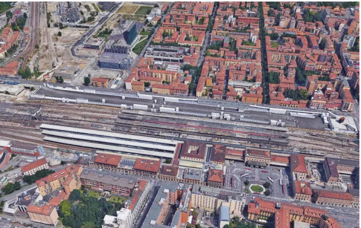
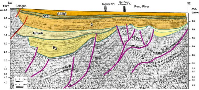
verification of the efficiency, for the optimization of the intervention layout and for a preliminary design of an optimized full-scale intervention. The case study is considered to be of interest as it illustrates an example of how it is possible to optimize the removal of LNAPL contaminants when these are substantially unrecoverable using traditional technologies. The Bologna railway station (Figure 2) was characterized by the presence of chlorinated solvents at low concentration in the groundwater.
Figure 2. Aerial photo of the new high speed railway station of Bologna.
The selected remediation strategy implied the creation of "reactive" zones capable of reducing the concentration of chlorinated solvents in groundwater through the combined action of adsorption on micrometric activated carbon, which is injectable into the aquifer and degradation of organic contaminants, stimulating the dechlorinating biological activity by addition of an electron donor (Ciampi et al., 2019b).The possibility to use a new dispersed colloidal activated carbon (Plumestop™, Regenesis) was experimentally investigated as a site-specific remediation approach (Georgi et al., 2015). The micrometric carbon can be easily injected in the contaminated aquifer, creating an in-situ adsorption zone able to reduce chlorinated aliphatic hydrocarbons (CAHs) concentration and to raise the kinetics of the
11
biological reduction by increasing the concentration of bioavailable CAHs at the carbon surface (Fan et al., 2017). The colloidal activatated carbon was co-injected with an electron donor (HRC™), to provide initial biostimulation of the treatment (Wood et al., 2006). Over the last decade, in situ application of activated carbon-based amendments has emerged as a promising remedial technology for the cleanup of subsurface organic contaminants such as chlorinated solvents (Simon, 2015; Fan et al., 2017). The technology involves the combination of adsorption, which has been extensively characterized and well understood, and degradation (Georgi et al., 2015; Simon, 2015; Fan et al., 2017). The combination of these two processes is proposed to be more effective than the conventional in situ remedial technologies that solely rely on degradation (Fan et al., 2017). Despite the rapidly increasing number of field-scale applications, questions remain to be answered regarding the effectiveness and persistence of contaminant degradation, especially biodegradation (Fan et al., 2017). The performance of in situ application of activated carbon-based amendments is heavily affected by the subsurface heterogeneity and the resulting uncertainty in the delivery and distribution of reagents (Fan et al., 2017). The selected remediation technology was verified through a pilot test, to obtain technical and operational information for the optimization of the intervention procedures on a larger scale. Based on the satisfactory results of the laboratory investigations (microbiological and microcosm tests) (Aulenta et al., 2005; Aulenta et al., 2007; Matturro et al., 2007), the design and implementation of a field test was performed as the final step of the evaluation process that led to the selection of an appropriate remediation technology according to the hydrogeochemical peculiarities of the site (Suthersan et al., 2016). The pilot test had to be representative of the process at full scale. The pilot test implementation provides useful information about the process efficiency and the actual extent of treatment, which may vary depending on the site’s subsurface characteristics. Analytical monitoring and integration of geophysical data during pilot test implementation facilitated the assessment of the remediation technology performance and the evaluation of possible modifications and integrations of the intervention strategy (configuration of injection points and quantity of product to be injected). The overall goals are to furnish a demonstration of the biodegradation processes in conjunction with contaminant adsorption for in situ subsurface remediation of chlorinated solvents with activated carbons and to illustrate how geological heterogeneity affects reagent distribution. The research illustrates the remediation measures adopted and the full-scale results of post-treatment monitoring for a period of 2 years. The results that led to the achievement of the
12
objectives and to the project closure derive from the integration of multidisciplinary data, using a multiscale approach. This research represents the first completed example in European territory for the remediation of an aquifer contaminated with chlorinated solvents by a combination of adsorption and biodegradation.
The industrial site operating in northern Italy (Figure 3) is characterized by the presence of active secondary sources in the low permeability layers and high concentrations of chlorinated solvents in soil and groundwater.
Figure 3. Industrial plant operating in north Italy.
This study investigates a new technology for the remediation of a dense non-aqueous phase liquid (DNAPL) aged source zone, with the aim of enhancing in situ bioremediation by coupling groundwater circulation wells with a continuous production system of electron donor. The technology was verified through a pilot test performed in a portion of the site highly contaminated by chlorinated aliphatic hydrocarbons. The multidisciplinary conceptual model confirmed a complex hydrogeological situation, with the occurrence of active residual sources in low permeability layers (Ciampi et al., 2019a). A new technology was used for the progressive remediation of DNAPL secondary sources—coupling
13
groundwater circulation wells (GCWs), with a production system of electron donor for the stimulation of in situ biological reductive dechlorination (Pierro et al., 2016). In this case, because of the geochemistry and hydrogeology of the site, the conventional addition methods are not suitable; traditional injection approaches are often limited by the preferential migration of injected fluids through better permeable zones, while delivery through less permeable and contaminated layers is usually limited (Petrangeli et al., 2016). On the other hand, Groundwater Circulation Wells (GCWs) could be considered a strategy for the progressive remediation of the source zone. This remediation technology is designed to create in situ vertical groundwater circulation cells, by drawing groundwater from an aquifer through one screened section of a multi-screened well, and discharging it through another screened section (Tatti et al., 2019). The pressure gradient between the two hydraulically-separated screen sections in the well induces a circulation flow in the aquifer, forcing water to move through a less permeable layer where residual sources of chlorinated aliphatic hydrocarbons (CAHs) are usually located (Petrangeli et al., 2016). In situ bioremediation involves the stimulation of microorganisms to metabolize or destroy contaminants through the addition of various amendments (biostimulation) to the subsurface environment (Aulenta et al., 2005). The combined technology is verified through a pilot test (the first of its kind) carried out in an operative industrial site located in the Po plain, which is heavily contaminated by CAHs. Based on the satisfactory results of the laboratory investigations (microbiological and microcosm tests), which indicated that reductive dechlorination might be successfully enhanced at the considered site (Aulenta et al., 2007; Matturro et al., 2013; Petrangeli et al., 2016; Pierro et al., 2017), the design and execution of a field test was performed as the final step of the evaluation process (Petrangeli et al., 2016; Pierro et al., 2016; Pierro et al., 2017). The pilot test intended to verify the possible mobilization of contaminants trapped in horizons with very low permeability, and the effective distribution of electron donor to stimulate the in situ processes of natural attenuation (Pierro et al., 2017). The pilot test was designed to optimize the layout and to calibrate the implementation of an optimized full-scale intervention, in order to check its efficiency. The application in the field during the pilot test determined the process efficiency and extent of treatment, which may vary depending upon the site’s subsurface characteristics. The pilot test results clearly demonstrate a significant mobilization of contaminants from the low permeability zone, and the possibility of favoring the in situ natural attenuation mechanisms based upon biological reductive dechlorination. The results obtained during the experimentation supported a
14
definitive design choice for the full-scale intervention. The implementation of the strategy in full scale will verify the effectiveness of the adopted technology for the persistent, low permeability contaminant source zones.
The selection and deployment of appropriate technologies for the remediation strategy rely on initial characterization activities (Brusseau, 2019). In environmental issues, geology-related factors control the migration of contaminant plumes and affect the performance of remediation technologies (Harris et al., 2004). Delineation and understanding of the geology and the hydrogeology of a contaminated site, considering its chemical-physical and biological aspects, are fundamental requirements for successful environmental remediation. The high-resolution characterization of underground geological heterogeneities, and the integration of different information, represent a key element for a remediation design, the optimization of interventions, and performance monitoring (Suthersan et al., 2016). The creation of a four-dimensional (4D) geographical database, (which also considers the time factor), enables the integrated management, representation, and analysis of different data (geological, hydrogeological, hydrogeochemical, and geophysical) (Artimo et al., 2008). Notably, the integration of geological, hydrogeological, and chemical data describes the geological– technical characteristics of the subsoil, the hydraulic properties of aquifers and also the potential pollution of environmental matrices (Raiber et al., 2012). These peculiar aspects, influenced by the local geological architecture, are unique site-specific elements, according to which it is possible to implement a targeted intervention for a remediation purpose (Suthersan et al., 2016). Georeferenced databases, GIS applications, and the new 3D modeling frontiers are an indispensable tool for the management of the complex set of data resulting from the characterization. They are equipped with tools for spatial analysis, integration of different methods of investigation, and graphic restitution of the results to visualize the environmental features (Wycisk et al., 2007). The representation of the geological structure through a 3D model facilitates its understanding and depicts the hydrogeological setting (Raiber et al., 2012). The dynamics linked to the groundwater flow play a fundamental role in the transport of contaminants (Seyedpour et al., 2019). Seifert et al. (2012) underline the importance of the conceptual geological model for calibrating variables and conditions in hydraulic modeling. Before presenting a conceptual model for the behavior and transport of pollutants, the hydrogeology and the physical structure of the soil must be understood (Adamsky et al., 2005). The numerical modeling of groundwater flow and transport, combined with a multiscale approach, finds application in the geological-hydrogeological
15
characterization of polluted sites and represents a valuable tool for assessing the relevance of minimal lithological-stratigraphic variations in the correct formulation of a hydrogeological model and in the subsequent adoption of a reclamation project (Bozzano et al., 2007). The geolocalization of the concentration data of chemical species provides a complete picture on the trend in time and space of contaminant concentrations. Detailed knowledge of all the aspects mentioned above optimizes the planned remediation and safety measures.
Furthermore, a 3D hydrogeochemical model represents the decision support system, which increases the effectiveness of the analysis, as it provides support to all those who must make strategic decisions (Wycisk et al., 2007). In the context of remediation of contaminated sites, the challenge to be faced is to simultaneously integrate the information relating to the hydrogeochemical sphere in all its dimensions (Harris et al., 2004). The construction of a multidisciplinary geodatabase and the realization of an integrated model achieve this objective. The multi-source geodatabase and the data-driven model represent the tools for the integrated management of heterogeneus and geo-referenced elements. This ensures the interchangeability of information in the multidisciplinary nature of the elements involved, contributing to the continuous convergence of different types of geomodeling. Their interaction and the high-resolution characterization of environmental variability support the design of a targeted and effective remediation strategy (Harris et al., 2004;Suthersan et al., 2016). Holding a significant amount of data, the integrated geodatabase allows useful information for decision-making processes to be extracted in a short time and in a versatile way (Suthersan et al., 2016). The presented research focuses on the essential role of the proper collection, storage, representation, and integration of geothematic data from different sources in defining reliable remediation strategies for a contaminated site. The aim of this thesis is to provide some evidence about the effectiveness of a single composite geodatabase, which integrates hydrogeochemical data, to act as a “cockpit” in the different phases of remediation strategy development-the definition of a conceptual model, the design of a remediation strategy, and the implementation, monitoring and validation of pilot tests, and full-scale interventions.
Application of data fusion to the characterization of contaminated sites incorporates geologic knowledge, geophysical data, geochemical analysis, direct sensing investigations, hydraulic test data, and observation of head to reduce uncertainly associated with subsurface
16
interpretation (Prasanna et al., 2008; Arato et al., 2014; Sauer and Dietrich, 2016; Kurup et al., 2017; Abbas et al., 2018; Gatsios et al., 2018). In this context, the challenge to be faced is to simultaneously integrate the information relating to the hydrogeophysical sphere in all its dimensions (Harris et al., 2004). The construction of a multidisciplinary geodatabase and the realization an integrated model represent the tools for the management and analysis of multi-source data. The information exchange, the overlapping of knowledge, and the high-resolution characterization of environmental variability capture the hydrogeological uniqueness, the geophysical peculiarity and the contamination dynamics. A real-time, immersive, interactive software, based on a ‘‘3D geospatial’’ graphical user interface (GUI), allows complex geological architectures to be depicted, and is more inherently intuitive than software based on a standard ‘‘desktop’’ GUI (Kingdon et al., 2016; Chiabrando et al., 2019). Many different hydrogeological and geophysical data sources can be combined into a single model. The spatial accuracy and dimensionality are preserved, making the multi-source model a practical reality. The possibility for the user to view, query and process data in 3D space is a significant extension of the standard desktop-based GUI, for human-computer interaction. In short, the model does not exist within a user interface, the model is the interface (Jones et al., 2009; Harvey et al., 2017) supporting the characterization and the decision-making processes. The presented research focuses on the essential role of the proper collection, storage, representation, and integration of geothematic data from different sources to reach the high-resolution characterization of underground geological heterogeneity, aquifer, and polluted areas, by providing an image of the subsoil at a level of detail rarely attainable. The high resolution of the multi-source characterization harmonizes the high accuracy, the density of information, the fusion of data, by generating a digital model that can be defined as a hybrid. The multitemporal and multidisciplinary geodatabase assumes the role of an effective “near real time” decision support system (DSS) (Huysegoms and Cappuyns, 2017) able to manage and release data from the characterization to the implementation of technique.
Experience has shown that conventional soil coring methods and groundwater monitoring methods are fraught with limitations that can lead to significant errors in the estimation of the amount and spatial distribution of NAPLs in the subsurface (Algreen et al., 2015). This leads to the development of inaccurate conceptual site models (CSM) and costly errors in remedial actions (McCall et al., 2018). Investigations on the origin and fate of hydrocarbons in the subsurface heavily rely on information related to the geological and hydrogeological
17
characteristics (Hunkeler, 2016). The CSM can’t prescind from the integration of the geological-hydrogeological and chemical-physical data, considering the geological-technical characteristics of the subsoil, the hydraulic properties of the aquifers, which are possible pathways of the contamination, and the potential pollution of the environmental matrices (Harris et al., 2004). Adequate characterization of this peculiar aspect and unique site-specific elements, which are influenced by the local geological architecture, is critically important for the sustainable use, protection, and remediation of groundwater resources (Suthersan et al. 2016). The investigation of contaminated sites is usually a long and expensive process. It is therefore desirable to use a combination of methodologies in an integrative approach that can reduce redundant information gathering (Abbaspour et al., 2000). The combined use of hydrological and geophysical measurements is arguably the most effective means of achieving this objective (Atekwana and Atekwana, 2010). Traditionally, the hydrological characterization of aquifers has been based on evidence from drill cores, hydraulic borehole logs, and tracer and pumping experiments (Leray et al., 2012; Hunkeler, 2016). Core- and borehole-based measurements can provide detailed local information, but such information is inherently 1D and spatially sparse in nature (Deiana et al., 2007), while tracer and pumping experiments tend to capture only the gross average properties of the probed subsurface region (Tronicke et al., 2004). Correspondingly, there is a large gap in terms of spatial coverage and resolution between these conventional hydrological techniques and hence they are, without complementary information, often inadequate for characterizing heterogeneous aquifers (Ruggeri et al., 2014). Geophysical methods have the potential of bridging this gap in resolution and coverage associated with traditional hydrological measurements, by capturing the data spatialization (Crook et al., 2008). The combination of different prospection technique adds additional and precious information, by capturing the complexity of geological heterogeneity and providing the data spatialization (Samouelian et al., 2005). Contaminant transport in groundwater is strongly controlled by geological heterogeneity, which plays a key role in a variety of scales. This implies the need to combine traditional and non-replaceable investigations that allow to acquire punctual information, with other linear prospects that facilitate the spatialization of data and are therefore able to capture the variability and complexity of transport processes. Different scenarios and configurations can then be appropriately simulated through the use of hydrogeological numerical models, based on the hydraulic parameters acquired with site and laboratory tests (Monego et al., 2010). The use of geophysical data from tracer
18
monitoring can be used to calibrate the hydrogeological model (Cassiani et al., 2006; Camporese et al., 2011). Combining the traditional and irreplaceable techniques of punctual prospecting (geological surveys and hydrogeological tests) with the linear survey techniques (geophysics) it is possible to capture in detail the underground geological variability and the complexity of the transport processes. Geophysical methods have emerged as valuable tools for supporting investigation of the shallow subsurface and for monitoring the dynamics of hydrological and biogeochemical processes that occur within it (Binley et al., 2010; Binley et al., 2015). Geophysical techniques have the advantages of reducing the need for intrusive investigations (Chambers et al., 2010), and can provide spatially continuous information regarding subsurface structure (Samouelian et al., 2005). A comprehensive site characterization and remediation design and testing can strongly benefit from the combination of indirect (GPR, ERT, EMI, EC) and direct (chemical) investigations that can lead to understanding the distribution of contamination (Cassiani et al., 2014). ERT, GPR, and EM profiles, associated with survey data, were used to study the electrical properties of a contamination plume (Atekwana et al., 2000). Some geophysical techniques can focus with adequate resolution onto possible links exist between the relevant measured physical quantities and the hydrological and environmental quantities of interest for contaminated site characterization (Cassiani et al., 2014). Constitutive relationships that link measured geophysical parameters to hydrological properties are essential for reliable hydrological interpretation of geophysical data. This allows upgrading a model easily by acquiring and adding new data or reinterpreting and validating existing information.
Most studies to date on contaminant-geophysical behavior have been purely empirical and an overarching physicochemical model that explains observed geophysical signals is currently lacking. Given the complexity of physicochemical processes within contaminated porous media, the search for universal models that link geophysical signals to contaminant characteristics is likely to be futile (Binley et al., 2015). The emergence of the laser-induced fluorescence (LIF) technique overcomes this limitation, providing direct information on the LNAPL migration and distribution (Teramoto et al., 2019). LIF is a direct sensing method for the screening, in real time and in situ, of the contaminants present in the subsoil. LIF technique uses ultraviolet (UV) laser light delivered via direct push boring tools to excite (put energy into) polycyclic aromatic hydrocarbons (PAHs) molecules present in LNAPLs and logging florescence with depth thereby allowing the distribution of LNAPL to be characterized semi-quantitatively within the subsurface. PAHs are particularly efficient at
19
being fluorescent when exited by UV light (Lu et al., 2014). LIF technology efficiently delineates petroleum, oil, and lubricant (POL) contaminants in the subsurface. All the usual forms of POLs, including; gasoline, diesel fuel, jet fuel, and hydraulic fluids, can be detected via the fluorescence response of their PAH constituents. Because this technology can be delivered using direct push equipment, it provides an efficient tool when used in conjunction with traditional core logging and sampling to more comprehensively characterize contaminant distribution (Gruiz et al., 2017). LIF measurements combined with cone penetrometer testing (CPT) were successfully used for time- and cost-effective in situ detection of fuels and petroleum products and proved to be effective in obtaining geophysical properties of subsurface environments (Pepper et al., 2002). The complete characterization of the site and the design of remediation tests can greatly benefit from the combination of indirect (geophysical) and direct (LIF-CPT, geological surveys, chemical water analysis, hydrogeological tests) investigations that can lead to understand the distribution of the contamination with high resolution detail. Surely, the integrated approach optimizes the effectiveness of the contribution of each sensor data and overcomes the limit of their singular applicability, making an experimental workflow effective from a global viewpoint.
The purpose of this research is to provide some evidence about the effectiveness of a single composite geodatabase, which integrates geological/hydrological, geophysical, and chemical data, to act as a “cockpit” in the different phases of definition of a conceptual model, selection/design of a remediation strategy, implementation, near real-time monitoring, and validation/revision of a pilot tests and full-scale interventions. The integrated data cockpit (Artimo et al., 2008) reflects the interdisciplinary action that involves the contribution and collaboration of the different scientific spheres to guarantee valid results in qualitative terms. The geodatabase favors the dynamic interchangeability of information in the multidisciplinary nature of the elements involved in the hydrogeochemical environment. The central system to organize / return even heterogeneous data (Huysegoms and Cappuyns, 2017) is a support tool for the evaluation and design of targeted, effective, and economically sustainable remediation interventions (Suthersan et al., 2016). Contaminated site remediation can’t disregard from the integration of different information related to the hydrogeochemical sphere in all its dimensions (McCarty, 2010). Geological uniqueness and chemical peculiarities guide the contamination dynamics and decontamination mechanisms in the environmental scene (Harris et al., 2004; Kueper et al., 2014). Their knowledge and the high-resolution characterization of environmental variability support an effective
20
remediation strategy. The multidisciplinary approach unites all the strengths of the different branches and considers the contamination phenomenon in all its dimensions, to obtain a high-resolution characterization (Harris et al., 2004). Geology can represent the link between the various disciplines (Figure 4), favoring the information interchangeability in the multidisciplinary nature of the elements involved (Suthersan et al., 2016). The holistic approach supports the design of targeted, effective, and economically sustainable remediation interventions.
Figure 4. Schematic illustration showing how geology represents the link between different disciplines in the remediation of contaminated sites.
21
2. MATERIALS AND METHODS
2.2 An Integrated Geodatabase for the Management of Contaminated Sites
This research highlights the role and the potential of integrated geodatabases for the management of remediation processes, based on the design and implementation of innovative remediation strategies in 3 polluted sites in Italy: the Decimomannu military airport, the Bologna high-speed railway station, and an industrial site operating in north Italy. The management of a large amount of heterogeneous data supported the entire remediation projects, from the characterization phases up to the application of the interventions (Suthersan et al., 2016). A large amount of multithematic data was stored and centralized in an integrated information management and analysis platform. The multidisciplinary geodatabase contains information related to geological, geotechnical, geophysical, hydrological, and chemical spheres (Figure 5).
Figure 5. Representation of the multidisciplinary dataset used for the management and the storage of heterogeneous data.
22
The geodatabase also contains information related to variuos tests performed in the different sites and in laboratory (more than 50 particle-size analyses, 32 LIF investigations, 15 ERT lines, 15 triaxial cell permeability tests, slug and pumping tests, Lefranc tests, determinations of Atterberg limits, and assessments of water content). Most of the field and laboratory activities were carried out as part of my research activity. 7 particle size tests and Lefranc tests were inherited from previous studies. The data cockpit assumed the role of an effective “near real time” decision support system (DSS), able to manage and release data from the characterization to the technique implementation (Huysegoms and Cappuyns, 2017). The collection of hydrogeochemical data was rendered in digital format through the creation of a 4D geodatabase that considered the time factor. The thematic database represented a georeferenced data storage model used for processing and editing (Artimo et al., 2008).
2.3 Contextual Data Collection and Activities
2.3.1 The Military Site
During the site characterization phases, many geological surveys, permeability tests, geophysical prospectings, soil and groundwater samplings were executed at the military site. The advanced geological modeling followed the archiving of stratigraphic data in the geodatabase. It contains stratigraphic data referring to 85 geological surveys realized inside the base area (Figure 6).
23
Figure 6. Stratigraphic log realized inside the Decimomannu military base.
Stratigraphic logs were carried out from 2007 to 2016. They reach depths ranging from 10 m to 26 m and cover an investigation area of about 265000 m2. During the drilling activities soil samples were collected to perform laboratory analysis. Ten granulometric tests (ASTM International, 2011) provided the geotechnical description of the soils constituting the
24
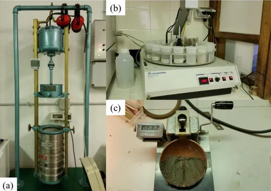
shallow aquifer. As known, it is possible to associate to the lithotype grain size a typical range of hydraulic conductivity coefficient (Lambe and Whitman, 1979). Geological surveys and laboratory analyses identified the lithotechnical units and evaluated the permeability of the stratigraphic horizons present in the subsoil (Safarbeiranvnd et al., 2018). Fifteen Lefranc field tests (Zhang et al., 2018), two permeability tests in traixial cell, two pumping tests (Gatsios et al., 2018), and ten slug tests (Maliva, 2016) supplied hydrodynamic parametrization of a strongly heterogeneous and anisotropic aquifer (Figure 7).
Figure 7.Instrumentation used for pumping tests (a, b) and slug tests (c).
The pumping tests were implemented by pumping a constant flow rate for a sufficiently long time (24 hours) in a well and measuring the drawdowns in one or more monitoring points (well / piezometer). Hydrogeological tests provided the hydraulic boundary definition of the subsoil portion close to the fuel storage area.
The evaluation of hydrodynamic parameters furnished the elements to evaluate the velocity of groundwater flow (Chidichimo et al., 2015). The hydrogeological and hydrochemical setting was assembled based on a piezometric network consisting of 62 measurement points. The reconstruction of the evolution of the groundwater contamination status was reproduced based on the chemical analyses of waters sampled in the monitoring network, in the period 2011-2018. To visualize the evolution of the groundwater contamination status,
25
contour maps were created for the parameter considered representative of the contamination. Several thematic maps were produced by considering the total petroleum hydrocarbons (TPH), which are correlated with the state of contamination that was previously ascertained. The concentration values (in μg/L) were compared to the Italian threshold limits (CSC)—the limits between each class corresponded to multiples of the CSC value for each contaminant. A detailed speciation, through GC-MS, of supernatant that has been occasionally detected over the years in the piezometric monitoring network provided interesting indication about the contamination dynamics and the "aging" of potential secondary sources of contamination. The integration of analytical data within the geodatabase had for purpose the development of a conceptual model that considers extension and degree of contamination, characteristics, and chemical-physical parameters that condition the mobility and the division between the phases of the pollutants.
To strength and refine the geological model, which arises from the interpolation of punctual data, geophysical investigations were carried out by performing fifteen electrical resistivity tomography (ERT) profiles (Binley and Kemna, 2005). The realization of 15 prospecting lines using ERT aimed to provide the evaluation of the variation of the electrical properties of the subsoil in a horizontal and vertical direction, furnishing the spatialization of data in two dimensions (Crook et al., 2008). Note that the ERT line geometry determines the maximum depth of investigation, that can be estimated to reach 1/4 to 1/5 of the line length (Cassiani et al., 2006). In the case here considered, generally lines of 94 electrodes with a 0,5 m spacing were deployed, and thus we could only reach a depth of about 10 m. This implies that the ERT investigation can image reliably only the shallow aquifer. The electrode configuration type employed in electrical prospecting was the dipole-dipole array, and more precisely a skip-4 dipole-dipole (i.e., the dipole size is equal to 5 times the electrode spacing, in total 2,5 m). The acquisition was conducted using a Syscal Pro 72 produced by Iris Instruments. For the data inversion, and thus the production of the imaging results, we used the open software ProfileR provided by A. Binley (Cultrera et al., 2018). While geophysics may differentiate low-permeability and high-low-permeability units, is extremely challenging to search for universal models that link geophysical signals to contaminant characteristics (Binley et al., 2015). On the other hand, the LIF technique opens the possibility of a more precise estimation of the LNAPL migration and extent in a complex distribution scenario (Teramoto et al., 2019). LIF investigation were implemented for the continuous detection of pollutants along a vertical profile with a high spatial resolution (Figure 8).
26
Figure 8. Conical tip adopted to realize the LIF profiles (a), truck used to transport the equipment inside the air base, fluorescence signal acquired in real time.
Currently available LIF equipment is not designed to detect dissolved-phase contaminants (Fedotov et al., 2019). The realization of 30 survey points using the LIF- ultra violet optical screening tool (UVOST) technology intended to add precious indication on pollutant characteristics and contamination dynamics. The combination of the above-mentioned direct sensing techniques with CPT measurements envisaged to capture the high-resolution characterization of the geological structure and the contamination state of the saturated and unsaturated subsoil. The data thus acquired were organized, georeferenced, and stored in a geodatabase, also useful for the purposes of visualization and data processing.
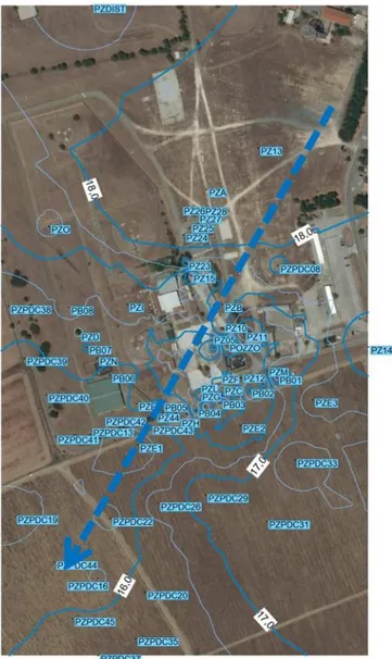
2.3.2 Bologna
At the contaminated site of the new high-speed railway station of Bologna, a large amount of slightly contaminated soil (~1.000.000 m3) was excavated to create the new underground
27
train station. The excavation activities for the construction of the structure that houses the station involved the removal of land attributable to shallow and intermediate aquifers. In correspondence of the excavation, a bypass system made of activated carbons for the treatment of groundwater was realized prior to our intervention. In the study area, 47 stratigraphic logs from boreholes drilled between 2005 and 2014 were available. A further 17 boreholes were drilled within the characterization activity, for refining the geological model and taking soil samples useful for laboratory tests. Geological surveys and laboratory analyses identified the lithotechnical units and evaluated the permeability of the stratigraphic horizons present in the station subsoil (Cheong et al., 2008). The stratigraphic data were re-interpreted and homogenized for a hydrogeological perspective, i.e., the various stratigraphic levels were merged or differentiated according to grain size and, therefore, permeability (Mirus, 2015). The subsoil geological structure was subdivided with reference to the elaborate groundwater circulation scheme. Permeability was evaluated via small-scale in situ tests (5 Lefranc tests), as a function of the particle size, and through permeability tests in triaxial cells. Twenty-one soil samples were collected to perform particle size tests (ASTM International, 2011), determination of Atterberg limits (ASTM International, 2010a), and assessments of water content (ASTM International, 2010b) (Figure 9).
Figure 9. Instrumentation employed for laboratory tests: mechanical shaker and X-ray sedifer for granulometric analysis (a, b), Casagrande’s spoon used for the determination of the liquid limit (c).
28
These analyzes were realized at the Applied Geology Laboratory of the University of Rome - "La Sapienza". The data thus acquired were organized according to a hydrostratigraphic criterion (Mirus, 2015), georeferenced, and stored in a geodatabase, also useful for the purposes of visualization and data processing.
At the Bologna railway station, the geo-referencing of previous data and new periodic measurements allowed the realization of the hydrogeological structure modeling and the reconstruction of the groundwater circulation scheme. The evaluation of hydrodynamic parameters quantified the velocity of groundwater flow (Chidichimo et al., 2016). The hydrogeological setting was assembled based on a piezometric network consisting of 61 measurement points. Twenty-nine e thirty-two piezometers that intercept respectively the shallow and the intermediate aquifer were considered. The reconstruction of the evolution of the groundwater contamination status was reproduced based on the chemical analyses of waters sampled in the monitoring network. A total of 180 monitoring campaigns were conducted in the period 2005-2019. Several thematic maps were produced by considering some key contaminants, which are correlated with the state of contamination that was previously ascertained. The concentration values were compared to the Italian threshold limits (CSC)—the limits between each class corresponded to multiples of the CSC value for each contaminant. Thematic maps were created for the most relevant parameters, i.e., TCE and PCE concentration values, to visualize the evolution of groundwater pollution and to identify intervention areas. To investigate the contamination dynamics, we grouped the data considering the different phases of construction of the train station. These correspond to the different phases of aquifer response to possible sources of contamination. For each of the parameters and for each considered aquifer formation, contour maps for the following phases were produced:
1) Pre-operative (Oct 2004 - May 2006);
2) Preliminary excavations (May 2006 - Oct 2009); 3) Excavation (Oct 2009 - Aug 2011);
4) Post-excavation (Aug 2011 - Jan 2013); 5) Post-operative (Jan 2013 - Dec 2014).
In the industrial plant area, 83 stratigraphic logs from boreholes drilled between 2001 and 2014 were available. A further four boreholes were drilled within my activity (2017) for refining the geological model and taking soil samples useful for laboratory tests. Forty-eight
29
particle-size analyses (ASTM International, 2011), 12 triaxial cell permeability tests, determinations of Atterberg limits (ASTM International, 2010a) and assessments of water content (ASTM International, 2010b), offered the analytical evaluation of the textural and permeability characteristics. The particle-size tests, Atterberg limits determination and permeability definition through the triaxial cells (Figure 10), were performed at the Applied Geology Laboratory of the University of Rome—"La Sapienza".
Figure 10.Instrumentation used for the determination of permeability in a triaxial cell.
The data thus acquired were organized according to a lithotechnical criterion, i.e., considering the granulometric and hydraulic conductivity characteristics which are the most influential on groundwater circulation (Cheong et al., 2008).
2.3.3 Industrial Plant
The geo-referencing of previous data and new periodic measurements in 95 piezometers installed inside the industrial plant allowed the realization of the hydrogeological structure modeling and the reconstruction of the groundwater circulation scheme (Xiao et al., 2016; Adhikary and Dash, 2017; Safarbeiranvnd et al., 2018). The storage, processing and representation of data monitoring in a geographic information system (GIS) environment reconstructed the evolution of the groundwater contamination status over time (Kourgialas
30
and Karatzas, 2015; Mirzaei and Sakizadeh, 2016; Safarbeiranvnd et al., 2018). Thematic maps, representing the groundwater contamination status evolution, were produced based on the chemical analyses of waters sampled in the monitoring network in the period of 2008– 2017. This type of representation permitted the visualization of the evolution status of groundwater pollution, the identification of the areas impacted by contamination, and the individuation of the intervention areas. The spatial overlay of the geological and hydrochemical models provided important indications on the contamination dynamics (Harris et al., 2004). The geological sections, extracted from the 3D solid model, were enriched by the hydrochemical data relating to the concentrations of contaminants detected in the multilevel piezometers (Mayo, 2010), which were located in the pilot test area. A multilevel system is a groundwater monitoring device which allows the monitoring of a number of discrete groundwater zones within the subsurface. Installation multilevel systems can provide three-dimensional data regarding a site for more accurate source and plume delineation. The hydrochemical profiles were extrapolated from contamination models which were generated for data referred to monitoring campaigns carried out from 2014 to 2016.
2.4 A Multidisciplinary and Multiscale Approach Supporting the Remediation
Strategy
The hydrogeophysical model analysis and the remediation technology selection have been achieved previously using multiscale and multiphase approaches (Bozzano et al., 2007). In the first phase, the main hydrogeophysical and hydrogeochemical characteristics, surrounding the different sites at full scale, were detected. In the second phase, starting from the multidisciplinary conceptual model obtained from the first one, the analysis focused on the pilot test areas, increasing the observation scale to analyze in detail the effects of geological heterogeneity and chemical peculiarity in the first intervention area. The advanced geological modeling at both scales followed the reworking of stratigraphic data and their archiving in the geodatabase.
The hydrogeological 3D models were reconstructed by means of RockWorks 17 software (Lekula et al., 2008). This software enabled the acquisition, analysis, visualization and
31
integration of information from geo-referenced data. The data integration and analysis phase involved the interpolation and processing of the geological, geophysical, and hydrochemical parameters (Kalirai et al., 2015, Safarbeiranvnd et al., 2018). The parameters include the characteristics of stratigraphic horizons, groundwater levels, LIF data, geophysical information, and the chemical analysis of water sampled. Data belonging to different scientific spheres were elaborated with the inverse distance weighted geostatistical method (Mirzaei and Sakizadeh, 2016; Adhikary and Dash, 2017; Safarbeiranvnd et al., 2018) to obtain an integrated multidisciplinary model. The interpolation of punctual data, performed using appropriate algorithm, generated three-dimensional models, which illustrate the spatial distribution of the parameters obtained from all the investigations. The 3D georeferenced model allows useful information for the decision-making process to be extracted in a short time and in a versatile way (Lekula et al., 2008). The 3D voxel-based solid model (Wang et al., 2012) is able to overlap information related to the different scientific spheres. Three-dimensional digital models are a powerful way of visualization, analysis, integration, and interpretation of multi-source information. The combination of these highly complementary data types – geology, hydrogeology, geophysics, direct sensing, geochemistry – enables the production of value-added photorealistic outcrop models, adding new information that can be used for capturing the geological uniqueness and the contamination peculiarity.
Following an accurate reconstruction of the geochemical peculiarities, the realization of laboratory tests (microbiological and microcosm tests) evaluated the possibility to implement particular remediation strategies. The comparative evaluation of potentially applicable interventions was also accomplished based on laboratory experience. Based on the results obtained from the site characterization, microbiological (Matturro et al., 2013), and microcosm (Aulenta et al., 2005; Aulenta et al., 2007) studies, pilot tests were designed to optimize the operating conditions at the field scale. The application in the field during the pilot test determined the process efficiency and extent of treatment, which may vary depending on the site’s subsurface characteristics. Based on the results of the laboratory investigations (microbiological and microcosm tests), the design and execution of a field test was then performed as the final step of the evaluation process (Petrangeli et al., 2016; Pierro et al., 2017).
32
The remediation technology selection was achieved moving from the laboratory to the pilot to select/optimize an appropriate strategy to be implemented in full scale. The analysis of the hydrogeochemical model and the selection of the remediation strategy followed a step by step process, considering all the aspects involved in the environmental arena (geology, hydrogeology, geochemistry, geophysics). The pilot test was designed to optimize the layout of the intervention, to check its efficiency, and to calibrate the full-scale intervention. The realization of a pilot test was aimed to verify the feasibility of proposed remediation solutions. The field test is an expression of the holistic approach employed. It promotes an interdisciplinary action and an integrated intervention, combining all the strengths of the various disciplines and considering the contamination phenomenon in all its dimensions (Harris et al., 2004; Suthersan et al., 2016). The results of the experimentation, from the laboratory to the field pilot test, supported a definitive design choice that implies, for the full-scale intervention, the implementation of an innovative remediation strategy, determining the remediation of the entire identified contamination source.
During the pilot testing some investigations were realized, to evaluate the effectiveness of adopted remediation interventions.Some surveys were executed in the pilot test area using direct push (Geoprobe) penetrometers (Hunkeler, 2016) and a passive groundwater sampling system was installed (Figure 11).
33
Figure 11. Passive groundwater sampling system.
Among the monitoring activities, a specific role was played by time-lapse geophysical investigations. The use of repeated geophysical measurements to highlight changes in the system state is state-of-the-art for several hydrological applications (Cassiani et al., 2006; Deiana et al., 2008; Perri et al., 2012; Haaken al., 2017) but it is of relatively scarce use at contaminated sites, particularly during remediation activities. These methods can provide nevertheless potentially critical information, especially in terms of where and how in situ remediation actions affect different portion of the subsurface, as an effect of subsoil hydraulic heterogeneity (Vereecken et al., 2006). In fact, the physical variable of interest, i.e., electrical resistivity, is strongly related to state variables of key environmental interest (Lesmes and Friedman, 2005). Geophysical surveys and groundwater sampling were realized to control the effectiveness of the intervention, both in terms of product diffusion capacity and in terms of effective reduction of pollutant concentrations (Figure 12).
34
Figure 12. Pump used for the injection of different reagents in groundwater (a, b, c), ERT line realized in conjunction with the injection of amendments.
The study of the pilot test provided the elements for the verification of the efficiency, for the optimization of the intervention layout, and for the design of an optimized full-scale intervention.
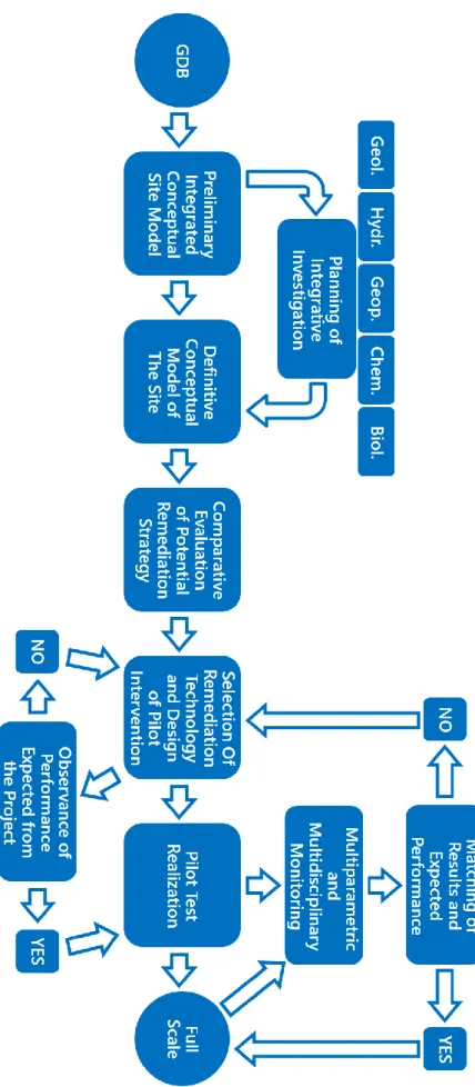
The analytical monitoring of the piezometric network allowed to weigh the yield of the remediation technology used, thus indirectly assessing the performance and contribution of the methodology developed to design the intervention. To verify the effectiveness of the interventions implemented in full-scale as a result of the previous activities, the work carried out consisted in i) monitoring of the piezometric network, ii) sampling and repositioning of passive samplers (Snap Sampler) in some monitoring piezometers. Monitoring the effects resulting from the full-scale interventions played a fundamental role, since the innovative remediation technologies used must be validated at a performance level. The thematic database act as an integrated and continuously updated tool, able to optimize the investigations during the characterization phase, support the choice of the strategies in planning phase, managing and calibrating in progress the intervention modalities according to innovative approaches during the remediation phase (Figure 13).
35
Figure 13. Flow chart illustrating the methodological approach followed in the various phases of work.