69 DISEGNARE CON
ISSN 1828 5961
dicembre 2009
Questo articolo propone una metodologia per la rappre-sentazione virtuale di Beni Culturali non più esistenti, che integra l’acquisizione dello stato di fatto attraverso le tecniche di rilievo 3D digitale, con l’analisi delle fonti storiche, letterarie, catastali ed iconografiche. L’uso del dato geometrico oggettivo come griglia interpretativa di partenza consente di costruire un metodo scalabile e riapplicabile su diversi manufatti. Il processo è qui sperimentato con la ricostruzione virtuale delle fasi evolutive di una chiesa emblematica per la sua storia tormentata: la Basilica di San Giovanni in Conca a Mi-lano. Attraverso tale ricostruzione viene proposta una rappresentazione realistica e comprensibile delle storia del manufatto, utile sia per l’analisi critica degli studiosi che per la valorizzazione turistica.
This article proposes a methodology for the virtual representation of lost Cultural Heritage monuments, based on the integration of a 3D digital survey of the remains, with the analysis of historical, literary, cadas-tral and iconographic sources. By using the objective geometrical data as initial interpretative grid, a scalable method is generated, suitable to be re-used on different artifacts. This approach has been experimented on the virtual reconstruction of different historical periods of a church characterized by a complex architectural devel-opment: the Basilica of San Giovanni in Conca in Milan. Realistic 3D digital representations of this monument allow to better understand the lost building changes, useful both for critical analysis of the experts or for touristic valorization.
Gabriele Guidi
È Professore Associato alla Facoltà del Design del Politecnico di Milano. È autore di oltre 120 pubblicazioni di livello internazionale prevalentemente su tematiche del rilievo e della model-lazione tridimensionale. Contribuisce come revisore per varie riviste ISI tra cui alcune delle prestigiose IEEE Tran-sactions.
Michele Russo
Architetto e Dottore di Ricerca, è do-cente presso la Facoltà del Design del Politecnico di Milano. Dal 2003 ad oggi si occupa di ricerche nell’ambito del rilievo 3D e della modellazione di-gitale dei Beni Culturali e del Design. Presente in progetti nazionali ed in-ternazionali quali “Rome Reborn” e la ricostruzione 3D del Foro di Pompei.
Rappresentazione diacronica di edifici antichi:
studi sulla basilica di San Giovanni in Conca a Milano
Diachronic representation of ancient buildings:
INTRODUCTION
Explanations and analysis based on the visualization of 3D digital models represent nowadays a possible way for valorization of cultural sites, capable to be aimed at different categories of users, ranging from scholars to simple tourists. The diffusion of these tools depends in part from the increasing interest on digital models as ideal repository for archeological data, conservation records, reconstructive interpretation of lost buildings and web diffusion of cultural 3D contents.
Different solutions based on the use of pre-rendered videos of 3D digital models or direct interaction with them has been successfully experimented so far. Some recent applications in the archeological field have dem-onstrated the communicative value of this first solu-tion3,4 and the potentiality of the second ones in terms of interaction and real-time definition of paths and
unu-sual points of view1, or connection of the model with descriptive data2.
Given a specific monumental building to be approached, the generation of such 3D models can be obtained ac-cording to two different criteria:
on the one hand a faithful representations of the monu-ment at its current condition can be generated, employ-ing advanced digital survey techniques such as digital photogrammetry and laser scanning, with a following modeling and representation processes based on true geometrical data;
on the other hand, a 3D digital reconstructions of the monument can be conceived, starting from historical information and drawings, and with a research ap-proach more oriented to the Humanities.
The first one presents well defined methodologies that allow to create accurate digital representations of the
artifacts as is in present time5. In the last decade the in-tegration between different survey methodologies were exploited in order to obtain the most accurate digital representation of a real object by improving the fea-tures of traditional survey processes6-11.
Methods for the definition of archetypal digital models present very different possibilities depending on the historical analysis approach. In the last decade experts in Digital Humanities12-15 have analyzed and discussed about the use of virtual interiors and environments representations as effective instrument for clearer dia-chronic analysis16 and therefore as a tool for discover-ing new archaeological results stackdiscover-ing on the possibil-ity to “see” what in the past was only possible to be imagined through descriptions. This point makes virtual reconstructions a new powerful scientific methodology in addition to the more obvious application for
increas-Diachronic representation of ancient buildings: studies on the “San Giovanni In Conca” Basilica in Milan 71 DISEGNARE CON
ISSN 1828 5961
dicembre 2009 Gabriele Guidi Michele Russo
ing the diffusion of archeological culture among the non experts. Methodologies for defining a coherent and ac-ceptable path aimed at creating digital reconstructions of buildings that at present time are remained only in part, are therefore needed if scientifically acceptable hipoteses have to be proposed.
For this reason the aim of this article is the definition of an integrated methodology that start from an high-resolution digital survey of the remains of an ancient building in order to gain the maximum geometrical knowledge of it, and stack on this for developing a co-herent virtual reconstruction through an iterative veri-fication of the different historical sources involved. All the sources, possibly altered by subjective interpreta-tion, metric errors in old surveys, approximations due to rough graphic representations, are therefore adapted and made coherent to each other by comparing them to
objective up-to-date geometrical references.
The following visualization of such complex 3D mod-els has the important role to render them clear, under-standable, intelligible, exploitable to common users, and with a certain level of interaction17. For this reason some research projects in the literature dealt with dif-ferent approaches and problems, from the study on 3D reconstruction and simulation of real monuments18 to the different type of interaction between users and 3D models20,21.
The process of designing an interactive 3D model rep-resentation of a Cultural Heritage monument presents different aspects of complexity. This is why this re-search deals with two crucial aspects for the whole pipeline: the definition of a methodology that integrate geometrical information extracted from 3D survey and historical data, with the main purpose to identify an
op-timal process of 3D reconstruction of lost buildings and the relative representations of their different historical phases, improving the comprehension of the artifact evolution by a diachronic model.
The 3D acquisition and modeling project of San Giovan-ni in Conca was promoted by the regional government in order to define a reliable methodology for generating 3D digital models of ancient monuments hidden under the surface of Milan and nowadays, with very few ex-ceptions, almost completely lost. For this purpose the application of virtual reality for the visualization of lost architecture in a realistic way was taken into considera-tion as a mean for giving new life to such hidden patri-mony, expecially interesting for the approaching EXPO 2015, that will be held in Milan.
By this point of view San Giovanni in Conca represented a very significant test for its complex historic evolution.
At last it became essential the definition of a non mon instruments of valorization of an artifact that com-bines an evident historic value with an invisible pres-ence inside the city.
HISTORICAL BACKGROUND OF THE BUILDING
The rests of the Basilica of San Giovanni in Conca are defined by a little apsidal portion and a crypt located in the center of Piazza Missori in Milan.The reduced ruin dimensions and their particular setting give few impor-tance to this particular ruin despite the well-know role of Basilica during the Romanic period.
Different historic sources place the beginning of the church foundation in the first century B.C.23-25,1 while is supposable its conclusion around the V-VI century B.C. The relevance of the church in that period is demon-strated by the presence of its name in the list of the
eleven Matrici churches and ten chapels served by the citizen mission.
In XI century different decorative and constructive Ro-manesque alterations were introduced in the church and the addition of the crypt.
While there are few historical sources that describe the thirteenth-century partial destruction of the building by Barbarossa, for sure it was appointed by the archbishop Ottone as church for the daily indulgences of the Lent period in 1284.
In the XIV century the ecclesial complex was enlarged and adorned with sculptures and frescoes thanks to Bernabò Visconti’s patronage.
In XVI century Francesco II Sforza lended the church to Carmelitani Fathers of Mantova congregation and some architectural modification were produced for the official visit of Carlo Borromeo. Beside the church there was a
high 24 meters massive bell tower. The period of foun-dation is not exactly known, but it’s well-known that the Carmelitani Fathers increased the height of this part of thirty ells (18 meters) in 1596. In the next two centuries different modifications and enlargements were brought for the achievement of lateral chapels and architectural restoration.
From XVIII century began some troubles of the building: in 1782 the church was taken away from Carmelitani Fathers as a consequence of the abolition of religious orders. Starting from 1808 the church was used by the Corona institution as barracks for Napoleon recruits and in the same year the bell tower was used as astronomic observatory. At the end of this period the deconsecrated church was rented to private customers for warehouse destination.
Diachronic representation of ancient buildings: studies on the “San Giovanni In Conca” Basilica in Milan 73 DISEGNARE CON
ISSN 1828 5961
dicembre 2009 Gabriele Guidi Michele Russo
town council decided to pull down the front spans of the building and sold it to the Waldensian community who was obliged to rebuild the facade and arrange the residual part of the complex. Colla was entrusted with the restorations that ended in 1881; the new facade was distorted to fit the actual oblique plan while the bell tower, at that point isolated in the middle of an empty square, was demolished in 1885.
During the Albertini’s Regulating Plan the complete demolition was realized until 1952 saving only the present apsidal ruins and the crypt. The facade was dismantled and reassembled on the new Waldensian church in Francesco Sforza Street.
3D ACQUISITION AND MODELING OF “SAN GIOVANNI IN CONCA”
Instruments
Different instruments were employed to gain enough information about the artifact for supporting the histori-cal and architectural analysis.
For acquiring the ruins geometry a 3D Time of Flight scanner (HDS3000) and a triangulation 3D laser scan-ner (Vivid Minolta 910) were used, and two digital re-flex cameras (Canon 5D and Canon 400D) for getting textures of the real construction materials employed. The instrument integrations allowed acquiring different level of details of the architecture and materials. For the historical analysis several literary sources were integrated, mainly defined by the description of artistic, historic and architectonic evolution, and cadastral and ichnographical sources that completed the historical overview. The presence of ancient maps, period plans,
drawings and paintings of the church allowed verifying the reliability of the historical sources providing the best interpretation of the past aspect of the building. In this step the pictures of the past period have assumed the crucial role of objective data.
All these sources converged to one historic evolution of the artifact characterized by few verified architectural phases.
Data acquisition
The 3D survey considered a 20x20 meters area com-posed by a middle-complex hypogeal portion with many columns and capitals and a less-complex external por-tion without sculpted elements.
During the survey project it was decided to use the big-ger part of the 3D acquired model as a reference base
for CAD modeling and only the little remaining part as direct information source.
This assumption required the definition of a dynamic resolution step in 3D acquisition, starting from 2 cm for architectural portions up to 0.4 mm for the sculped ones. Reference targets were not positioned in the survey scene for the evident presence of recognizable three-dimensional features in the environment that were used for aligning the range maps through an It-erative Closest Point (ICP) process.
During the 3D survey the TOF laser scanner HDS3000 was used for the massive 3D acquisition of the archi-tectonic portions of the apse and the crypt while the Vivid 910 instrument was applied in the 3D detailed acquisition of the most interesting capitals in the crypt. A complex network of acquisition points was defined in order to obtain redundant data, avoiding both the
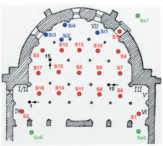
geo-metrical lack due to the shadow effect of the columns and reaching a good precision in the alignment step. The base of 3D acquisition grid was composed by 4 scans from the corners of the crypt (stations S1 to S4, with reference to figure 1) to maximize the field of view in relation with the column presence and one high reso-lution central scan (S5). Starting from these five scans, others 12 scans were acquired from every important crypt span (S6 to S17) and aligned with the residual 4 scans (Si1 to Si4) dedicated to the Roman foundation ruins.
The connection between crypt and apse was allowed by a crucial range map (S18) that linked some detailed portions of the internal part with the external ones. At the end 6 different range map were acquired (Se1 to Se6) to survey the external apse from different point of view. Side by side to this activity were acquired three
different capitals using 25 different detailed range maps for each one. At the end of the ICP alignment a final point cloud of 9 x 10⁶ points was obtained and re-sampled with different resolution steps in relation with the historical, architectonical and artistic relevance of the real model, from 20 cm step for the urban context to 2 cm for detailed portions; this solution allowed an optimal reduction of the point cloud for the creation of the polygonal model. All data process was carried out inside the Cyclone software (Leica Geosystem). At the same time a photo reportage was completed in order to integrate geometric information useful for the CAD reconstruction step and for the definition of a ma-terial repository necessary for the texturing phase. The color and dimension data were post-processed to op-timize the projection phase of the texture and the real-time visualization of the entire 3D model (Fig. 1).
Fig. 1. Laser scanning of the crypt, the absidal ruins and part of the surrounding environment of San Giovanni in Conca: a) lo-cations of the laser scanner for properly acquiring the geome-trical data taking into account the high number of occlusions in the crypt; b) final aligned point cloud, used for generating the polygonal model of the monument.
Diachronic representation of ancient buildings: studies on the “San Giovanni In Conca” Basilica in Milan 75 DISEGNARE CON
ISSN 1828 5961
dicembre 2009 Gabriele Guidi Michele Russo
Creation of the reality-based model
Only a little part of the acquired architectural data were processed to obtain a coherent resolution with the real geometric characteristics: the roman foundation ru-ins, the complex of vaults in the crypt and the closing portions of the apse wall, parts of the real artifact that couldn’t be represented in properly with CAD tools. The others parts were reduced 40 times from the original data in order to generate a simplified model suitable for the CAD re-modeling phase. From the detailed 3D acquisition three high resolution polygonal models of the capitals were defined each one by 80000 polygons. Every polygonal process was carried out inside Rap-idform (INUS Technology) and Polyworks (Innovmetric) software.
Starting from the real sections of the reality-based model, a sequence of simple geometrical shapes were
defined inside the Rhinoceros software (McNeel) in or-der to define the reference framework for the creation of a new archetypal geometry. The use of simple math-ematical primitives and surfaces simplified the digital data management, supported the interpretation of the model by the use of simple data as reference for the historical reconstruction, allowed to create a flexible digital model suitable for the iterative reconstructive in-terpretation that imply frequent geometry modification. During the digital modeling the distance between the new CAD geometry and the reality-based model was verified never above 5 cm. The final model defined by 210000 polygons was used as base for the application of the texture contained in the materials repository. For the definition of an actual environment of the church an up-to-date urban map was used as reference for the creation of simple building shapes, integrating the
space and elevation map information with the 3D data acquired by 3D laser scanner (Fig. 2).
Interpretative 3D model generation
The first step of the historic reconstruction process started from redesigning the past iconographical and cadastral representations with CAD instrument. These historic data lack in objectivity and mutual coherence, due in part for the representation style and the graphical instruments used, in part for the introduction of errors in survey and measurement restitution, the low preci-sion of the designer and the unsuited data preservation. The lack in objectivity requests a complex step of “trans-lation” and “mediation” between the rough graphic out-put of the traditional representation technique and the precise CAD geometries construction, trying to obtain a coherence between the drawing dimensions and the Fig. 2. Texturized polygonal model (reality based 3D model) of San Giovanni in Conca crypt
hypothetical past architecture. The presence of non coherent variation in dimension e proportion between historical plants, fronts and sections belonging to the different historical period can be avoided by an itera-tive comparison between the traditional representa-tions and the real relative dimensions coming from the reality-based 3D model (Fig. 3).
In this case different sections extracted from the reali-ty-based model were used to rescale the iconographi-cal sources and to verify their correct representation. Starting from the XII century Basilica plant as reference, a complex inspection process of all the other plants, fronts and sections has started in order to reach a se-quence of 2D representation acceptable from the geo-metrical and historical point of view (Fig. 4).
The 3D digital model reconstruction of the bell tower has followed only the facade information and proportion
contained inside the few historical pictures, due to the lack in other form of representation. At last the integra-tion of historical data coming from period drawings and the geometrical measurements contained in the real “revisited” facade of the Waldensian church played an important role for the 3D reconstruction of the ancient church facade (Figg. 5-6).
From 2D digital data started the process of 3D modeling of the different periods of the church. The combination between the complex level of 3D representation and the interpretation of reconstructive hypothesis, respect-ing the constructive and aesthetical rules of the period, represented the bottleneck of this step. A 2D drawing represents a form of incomplete spatial representation, effective for the geometrical description of a particular portion of the architecture but unsuited for the global knowledge and representation of the entire building. Fig. 3. Maps of the church at the different historical periods, normalized through the real 3D data: a) VI century; b) XIII century; b) XVI century; c) XIX century
Fig. 4. Inverse perspective reconstruction of the bell tower from an ancient photography taken before its demolition. Starting from the definition of three Accidental Points and the Rectangular Trihedron, the Principal Point (V0), the Distance Points and Circle were defined. The real architectural dimensions were extracted from the Horizon-tal (AB) and Vertical segments (ACD) obtained from the lines passed by Measure points (M) an image points and intersected with the Fundamental Line
Diachronic representation of ancient buildings: studies on the “San Giovanni In Conca” Basilica in Milan 77 DISEGNARE CON
ISSN 1828 5961
dicembre 2009 Gabriele Guidi Michele Russo
Instead of this in a 3D representation every single ele-ment have to be geometrically described since every portion of the digital model is connected with the others in a complex network of shapes. The type of interpreta-tion that involve both the principal shapes, the simpli-fied details and the connections between these network of shapes with the lack in historical descriptions define a more complex level of visualization (Fig. 7).
The modeling process if not supported by historical and iconographical sources is founded on constructive log-ics supported by an architectural vocabulary and local culture, defined in relation with the formal rules present in other churches nearby San Giovanni in Conca. FINAL RESULTS
From historical analysis four different evolutive phases of the architecture evolution have been defined.
Start-ing from the architectonic information extracted from different sources and 2D drawings began the procedure of 3D modeling. For the early Christian version of the church (VI century B.C.) the redesign process of the walls and roof started from the apsidal portion, using the surveyed model as initial reference. The definition of the second Romanesque version of XII century B.C. period began from the first reference structure of the early Christian Basilica with the addition of a little bell-tower and the introduction of some important construc-tive elements like a nave, two aisles, a transept and the crypt; the definition of this last element obliged to raise the apsidal floor and to introduce a stairs to reach the most sacred area of the church. In the third evolution step of XV century B.C. some different architectonical and aesthetical modifications were inserted both in the bell-tower and in the Basilica. The last significant
pas-Fig. 6. Sections of the church in the XVI version Fig. 5. Façade of the church in the different periods
Fig. 7. Modeling process starting from the 2D reconstruction driven by historical sources integrated by 3D real data
sage of the XVIII century B.C. presented the building in a maimed version preserving only the final part of the nave and aisles and the apse. The materials used to texturize the models considered both the preserved materials of the ruins and some materials acceptable for the period, in relation with a comparative material research present in similar churches in local context. All the CAD models were generated in Rhinoceros software (McNeel) and visualized in 3D Studio Max (Autodesk) (Fig. 8).
The sequence of 3D models of different period visual-ized in the same environment suggests a clear instru-ment of representation of the architectonical evolution of the building. The level of information of the 3D mod-els, the geometrical variation of the global structure and the details, the materials and light sources analysis al-low both a careful evaluation and a base for discussion
between experts about the interpretative choices and the variation introduced during the modeling step. In addition this kind of visualization represents a clearer and more involving instrument of communication for the comprehension of lost Cultural Heritage.
Experts can use 3D models as data repository, exploit-ing the interactive capacities and real-time visualization of the results for critical discussion or analyzing the ef-fects of the dynamic variations of materials and light parameters.
The extraction of simple measures or 2D thematic ta-bles from the 3D model can always be implemented as support for discussions or research in different fields. Texturized sections represent an example of informa-tion that can be extracted from a 3D texturized model and a hybrid but clear type of visualization of the final results, because it combines the detailed information of Fig. 8. Reconstructed models of the various periods: a) VI century;
b) XIII century; c) XVI century; d) XIX century. It can be noticed that the reconstruction of the most ancient version has been genera-ted without any reference to the surrounding area, while the other version has been rendered within a flattened version of the current building fabric in order to have a clearer idea of the chuch extention in comparison with the actual sctructure of the city.
Diachronic representation of ancient buildings: studies on the “San Giovanni In Conca” Basilica in Milan 79 DISEGNARE CON
ISSN 1828 5961
dicembre 2009 Gabriele Guidi Michele Russo
material and ambient with a clear and simplified inter-pretation of the whole aspect of the architecture (Fig. 9). CONCLUSION
The main goal of the article regards the definition of a diachronic digital model of a lost Cultural Heritage. Starting from a real example representative for its con-struction history, the church of San Giovanni in Conca in Milan, a method of survey and critical analysis based on the integration between bibliographical and icono-graphical sources and 3D geometrical survey is sug-gested, in order to obtain a complex system of knowl-edge about the building. Starting from this approach the critical aspects that can affect the whole 2D and 3D interpretation process of the church were exploited. The final results demonstrate that this kind of diachron-ic visualization represents an interesting “medium” of
communication suitable at different levels for experts that can use 3D models as a common field for discus-sion and analysis about the interpretative choices. In addition virtual reality offers an effective instrument for communication and knowledge transmission suit-able for the tourist valorization of the church, based on a clearer comprension of the historic evolution of the fabric and a more realistic and involving representation of the ancient aspects of the external Basilica and the interior ambient.
ACKNOWLEDGEMENTS
The authors desire to thanks Prof. Maurizio Boriani, Director of DPA Department at Politecnico of Milan, for the beginning impulse of the project and the support in the historic analysis with some precious considerations on the urban evolutions. Another important thank to Donatella Caporusso, Director of the Archeological Museum of Mi-lan, for the assistance in analysis and archaeological interpretation of the different phases of the Basilica. A special thank to Prof. Paolo Russo, head of the Laboratory of “Topografia and Fotogrammetria” at University of Ferrara for contributing, with a HDS 3000 laser scan-ner, to the acquisition of the whole church. At the end the authors desire to thank Sebastiano Ercoli for the consistent effort in the 3D modeling and texturing process of the crypt and Laura Micoli and Giorgia Morlando for the support in 3D acquisition and processing data.
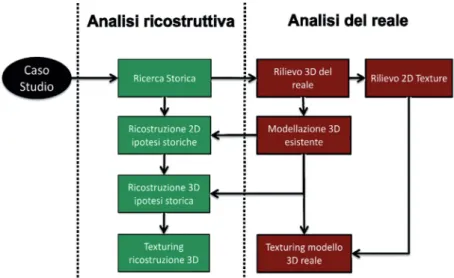
Fig. 9. Block diagram of the reconstruction process based on the integration of 3D measurements and historical analysis
REFERENCES
[1] Levoy, M., et al., The Digital Michelangelo Project. Procee-dings of ACM SIGGRAPH 2000 (New Orleans, July 23–28). ACM Press, New York, 2000, 131–144;
[2] M. Forte, “Musealizzare il virtuale: il progetto di allesti-mento multi-interattivo per la Cappella degli Scrovegni”, Ar-chè Srl, Bologna, 2002 [3] Stumpfel, J., Tchou, C., Yun, N., Martinez, P., Hawkins, T., Jones, A., Emerson, B., Debe-vec, P., 2003. Digital Reunifi-cation of the Parthenon and its Sculptures, in: 4th International Symposium on Virtual Reality, Archaeology and Intelligent Cultural Heritage (VAST), D. Ar-nold, A. Chalmers, F. Niccolucci (Editors), UK.
[4] Beraldin, J.-A. , Picard, M., El-Hakim, S.F., Godin, G., Valza-no, V., Bandiera, A., Latouche, C., 2002. Virtualizing a Byzan-tine Crypt by Combining High-resolution Textures with Laser Scanner 3D Data, in procee-dings VSMM 2002, Gyeongju, Korea, pp 3-14.
[5] Guidi, G., Russo, M., Beral-din, J-A., 2010. Acquisizione e modellazione poligonale, ed. McGraw Hill.
[6] Guidi, G., Beraldin, J-A., Cio-fi, S., Atzeni, C., 2003. Fusion of range camera and photogram-metry: a systematic procedure for improving 3D models metric accuracy, in: IEEE Transactions on Systems Man and Cyberneti-cs Part B-CybernetiCyberneti-cs, Vol 33-4, pp 667-676.
[7] Guidi, G., Tucci, G., Beral-din, J-A., Ciofi, S., Damato, V.,
Ostuni, D., Costantino, F., El Hakim, S. F., 2002. Multiscale archaeological survey based on the integration of 3D scanning and photogrammetry, CIPA WG 6 International Workshop on Scanning for Cultural Herita-ge Recording, Korfu, Greece, pp.58-64.
[8] Beraldin, J-A., 2004. Inte-gration of Laser Scanning and Close range Photogrammetry - the Last Decade and Beyond, in: Proceedings of the XXth ISPRS congress, Commission VII, Istanbul, Turkey, pp. 972-983. [9] El-Hakim, S., Remondino, F., Voltolini, F., 2008. Integra-ting Techniques for Detail and Photo-Realistic 3D Modelling of Castles. GIM International, Vol.22(3), pp. 21-25.
[10] El-Hakim, S., Beraldin, J.-A., Picard, M., Cournoyer, L., 2008. Surface Reconstruction of Large Complex Structures from Mixed Range Data - The Erechtheion Experience, in: The XXI Congress of the Internatio-nal Society for Photogrammetry and Remote Sensing (ISPRS 2008). July 3.
[11] Guidi, G., Remondino, F., Russo, M., Menna, F., Rizzi, A., Ercoli, S., 2009. A multi-reso-lution methodology for the 3D modeling of large and complex archeological areas, in: Special Issue in International Journal of Architectural Computing (IJAC), pp 39-55.
[12] AA.VV., 2002. Ut Natura Ars. Incontro sulla Virtual Rea-lity applicata all’archeologia, a cura di: D. Scagliarini Corlàita e A. Coralini, Bologna, 22 aprile 2002.
[13] Frischer, B., Niccolucci, F.,
Ryan, N., Barceló, J.A., 2002. From CVR to CVRO: the Past, Present and Future of Cultural Virtual Reality, in: Franco Nicco-lucci, editor, Virtual Archaeology between Scientific Research and Territorial Marketing, pro-ceedings of the VAST EuroCon-ference, Arezzo, Italy. [14] Frisher, B., Stinton, P., 2002. The importance of scien-tific authentication and a formal visual language in virtual mo-dels of archeological sites: the case of the House of Augustus and Villa of the Mysteries, in: Interpreting the Past. Heritage, New Technologies and Local Development, Ghent, 11-13 September.
[15] Guidi, G, Frischer, B, Lu-centi, I, Donno, J, Russo, M, 2008, Virtualizing ancient Im-perial Rome: from Gismondi’s physical model to a new virtual reality application, in Digital Matter and Intangible Heritage Issue of International Journal of Digital Cultural Heritage and E-Tourism (IJDCE), pp 240-252. [16] El-Hakim, S., Lapointe, J., Whiting, E., 2008. Digital Re-construction and 4D Presenta-tion through Time, in Procee-dings of the International Con-ference on Computer Graphics and Interactive Techniques, SIGGRAPH 2008, Los Angeles, California, August 11–15. [17] AA.VV., Beyond Illustration: 2D and 3D Digital Technolo-gies as Tools for Discovery in Archaeology edited by Bernard Frischer and Anastasia Dakouri-Hild. Archaeopress, 2008. [18] Cinotti, T.S., Raffa, G., Rof-fia, L., Taboni, C., Malavasi, M., Sforza, F., Vecchietti, E., 2003.
Archeologia virtuale e supporti informatici nella ricostruzione di una domus di Pompei, in: Archeologia e Calcolatori, n.14, pp.237-274.
[19] http://www.pompey.cch. kcl.ac.uk/3D_Visualisations. htm
[20] Allen, P., Feiner, S., Troccoli, A., Benko, H., Ishak, E., Smith, B., 2004. Seeing into the Past: Creating a 3D Modeling Pipeline for Archeological Visualization, in: proceedings of 2nd Interna-tional Symposium on 3D Data Processing (3DPVT).
[21] Bertino, E., Franzoni, S., Mazzoleni, P., Valtolina, S., 2005. Integration of Virtual Rea-lity and Database System Tech-niques, In: Databases in Net-worked Information Systems, Springer Berlin / Heidelberg, pp 92-103.
[22] http://www.romereborn. virginia.edu/
[23] Bianconi, C., 1787. Nuova guida di Milano per li amanti delle Belle Arti e delle sacre, e profane Antichità Milanesi, Stamperia Sirtori, Milano. [24] Castiglione, G.A., 1625. Mediolanenses Antiquitates, Pietro Vander, Leiden. [25] Lattuada, S., 1737. Descri-zione di Milano, Tomo II, Ed. Bi-blioteca Milanese, Milano. [26] Torre, C., 1714. Il ritratto di Milano, Milano.
[27] Addison, A.C., 2000. Emer-ging trends in Virtual Heritage, in: IEEE MultiMedia 7(2): 22-25.