Geographies of the Anthropocene
Open Access and Peer-Reviewed series
Editor-In-Chief: Francesco De Pascale (CNR – Research Institute for Geo-Hydrological Protection, Italy).
Co-Editors: Marcello Bernardo (Department of Culture, Education and Society, University of Calabria, Italy); Charles Travis (School of Histories and Humanities, Trinity College Dublin; University of Texas, Arlington). Editorial Board: Mohamed Abioui (Ibn Zohr University, Morocco), Andrea Cerase (Sapienza University of Rome, Italy), Valeria Dattilo (University of Calabria, Italy), Chair, Dante Di Matteo (Polytechnic University of Milan, Italy); Jonathan Gómez Cantero (University of Alicante, Spain; Young Scientists Club, IAPG), Nguvulu Chris Kalenge (University School for Advanced Studies IUSS Pavia, Italy), Battista Liserre (Aix-Marseille University, Campus ESSCA, France), Giovanni Messina (University of Palermo, Italy), Gaetano Sabato (University of Catania, Italy), Carmine Vacca (University of Calabria, Italy).
International Scientific Board: Marie-Theres Albert (UNESCO Chair in Heritage Studies, University of Cottbus-Senftenberg, Germany), David Alexander (University College London, England), Loredana Antronico (CNR – Research Institute for Geo-Hydrological Protection, Italy), Lina Maria Calandra (University of L’Aquila, Italy); Salvatore Cannizzaro (University of Catania, Italy), Fabio Carnelli ((Polytechnic University of Milan, Italy); Carlo Colloca (University of Catania, Italy), Gian Luigi Corinto (University of Macerata, Italy); Roberto Coscarelli (CNR – Research Institute for Geo-Hydrological Protection, Italy), Sebastiano D’Amico (University of Malta, Malta), Armida de La Garza (University College Cork, Ireland), Elena
Dell’Agnese (University of Milano-Bicocca, Italy; Vice President of IGU), Piero Farabollini (University of Camerino, Italy), Giuseppe Forino (University of Newcastle, Australia), Virginia García Acosta (Centro de Investigaciones y Estudios Superiores en Antropología Social, CIESAS, México); Cristiano Giorda (University of Turin, Italy), Giovanni Gugg (University of Naples “Federico II”, Italy, University of Nice Sophia Antipolis, France), Luca Jourdan (University of Bologna, Italy), Francesca Romana Lugeri (ISPRA, University of Camerino, Italy), Fausto Marincioni (Marche Polytechnic University, Italy), Cary J. Mock (University of South Carolina, U.S.A.; Member of IGU Commission on Hazard and Risk), Francesco Muto (University of Calabria, Italy), Gilberto Pambianchi (University of Camerino, Italy; President of the Italian Association of Physical Geography and Geomorphology), Silvia Peppoloni (Istituto Nazionale di Geofisica e Vulcanologia, Italy; Secretary General of IAPG; Councillor of IUGS), Isabel Maria Cogumbreiro Estrela Rego (University of the Azores, Portugal), Andrea Riggio (University of Cassino and Southern Lazio, Italy; President of the Association of Italian Geographers), Bruno Vecchio (University of Florence, Italy), Masumi Zaiki (Seikei University, Japan; Secretary of IGU Commission on Hazard and Risk).
Editorial Assistant, Graphic Project and Layout Design: Franco A. Bilotta;
Website: www.ilsileno.it/geographiesoftheanthropocene;
The book series “Geographies of the Anthropocene” edited by Association for Scientific Promotion “Il Sileno” (Il Sileno Edizioni) will discuss the new processes of the Anthropocene epoch through the various worldviews of geoscientists and humanists, intersecting disciplines of Geosciences, Geography, Geoethics, Philosophy, Socio-Anthropology, Sociology of Environment and Territory, Psychology, Economics, Environmental Humanities and cognate disciplines.
Geoethics focuses on how scientists (natural and social), arts and humanities scholars working in tandem can become more aware of their ethical responsibilities to guide society on matters related to public safety in the face of natural hazards, sustainable use of resources, climate change and protection of the environment. Furthermore, the integrated and multiple perspectives of the Environmental Humanities, can help to more fully understand the cultures of, and the cultures which frame the Anthropocene. Indeed, the focus of
Geoethics and Environmental Humanities research, that is, the analysis of the way humans think and act for the purpose of advising and suggesting appropriate behaviors where human activities interact with the geosphere, is dialectically linked to the complex concept of Anthropocene.
The book series “Geographies of the Anthropocene” publishes online volumes, both collective volumes and monographs, which are set in the perspective of providing reflections, work materials and experimentation in the fields of research and education about the new geographies of the Anthropocene.
“Geographies of the Anthropocene” encourages proposals that address one or more themes, including case studies, but welcome all volumes related to the interdisciplinary context of the Anthropocene. Published volumes are subject to a review process (double blind peer review) to ensure their scientific rigor.
The volume proposals can be presented in English, Italian, French or Spanish. The choice of digital Open Access format is coherent with the flexible structure of the series, in order to facilitate the direct accessibility and usability by both authors and readers.
EARTHQUAKE RISK PERCEPTION,
COMMUNICATION AND
MITIGATION STRATEGIES ACROSS
EUROPE
Piero Farabollini
Francesca Romana Lugeri
Silvia Mugnano
Editors
6
CONTENTS
Preface 8
Introduction 12
Section I
Mitigation Strategies of Seismic Risk
1. Urban Seismic Risk Reduction and Mitigation Strategies in Turkey
Ahmet Anıl Dindar, Cüneyt Tüzün and Aybige Akinci 19
2. A Collection of Statistical Methods for Analysis of the Disaster Damages and the Seismic Regime
Vladilen Pisarenko, Mikhail V. Rodkin 43
3. Turkey’s Earthquake History and Institution Based Earthquake Reduction Policies and Strategies
Alper Uzun, Burak Oğlakci 64
4. Risk Mitigation through Local Building Knowledge: Turkish Van Region Case Study
Chiara Braucher, Mattia Giandomenici 84
Section II
Communication and Prevention Strategies of Seismic Risk
5. Communication-Based Prevention Strategies: A Draft Model Proposal
Andrea Volterrani 105
6. Geoscientists’ Voice in the Media: Framing Earth Science in the Aftermath of Emilia 2012 and Amatrice 2016 Seismic Crises
Andrea Cerase 123
7. The 2016 Earthquake in Central Italy. The Alphabet of Reconstruction
7
8. Food Management in Disasters: the Case Study of the Earthquakes of 24 August 2016 in Central Italy
Fausto Marincioni, Eleonora Gioia, Mirco Zoppi,
Elena Vittadini 172
Section III
Resilience and Post-Disaster Recovery
9. An Historical Flight and Some Open Questions towards a Pluralistic but Holistic View of Resilience
Maurizio Indirli 194
10. Earthquakes and Society: the 2016 Central Italy Reverse Seismic Sequence
Piero Farabollini, Serafino Angelini, Massimiliano Fazzini, Francesca Romana Lugeri, Gianni Scalella,
GeomorphoLab 249
11. Second Home Holidays Makers Recovery After a Disaster: Insights from the 2016 Central Italy Earthquake
Silvia Mugnano, Fabio Carnelli, Sara Zizzari 267
12. Assessing Resilience of Mountain Communities Hit By The Central Italy Earthquakes of 2016
Teresa Carone, Giulio Burattini, Fausto Marincioni 285
249
10. Earthquakes and Society: the 2016 central Italy reverse
seismic sequence
Piero Farabollini1, Serafino Angelini2, Massimiliano Fazzini3, Francesca Romana Lugeri4, Gianni Scalella5, GeomorphoLab6
Abstract
2016 August 24: an intense earthquake hits central Italy. The area is more extended than ever in the recent Italian history, involving four Italian Regions: Lazio, Abruzzo, Marche and Umbria. The seismic sequence is intense and prolonged, continuing also in 2017. The present work aims at representing a cognitive and interpretative contribution to the surface evidences produced during the seismic crisis of central Italy, particularly referring to the numerous effects on the environment, both primary (superficial faulting) and secondary, related to shaking. Moreover, the vastness of the involved area suggests the need of approaching the reconstruction by following new criteria, set on the integration of technical-scientific knowledge, socio-economic requirements and - above all – prevention.
Keywords: 2016 Earthquakes, Central Italy, Prevention, Seismic sequence, Society
1 Corresponding Author; Extraordinary Government Commissioner for the reconstruction in
the earthquakes areas of the 2016 and 2017; Scuola di Scienze e Tecnologie, Sezione di Geologia, Università degli Studi di Camerino, Via Gentile da Varano, 1, 62032 Camerino (MC); e-mail: [email protected].
2 CIA Lab S.r.l., Via Mutilati e Invalidi del Lavoro, 29, 63100 Ascoli Piceno.
3 Scuola di Scienze e Tecnologie, Sezione di Geologia, Università degli Studi di Camerino,
Via Gentile da Varano, 1, 62032 Camerino (MC).
4 Servizio Geologico d’Italia - ISPRA, Via Vitaliano Brancati, 48, 00144 Roma, e-mail:
5 Regione Marche, via Gentile da Fabriano, 9, 60125 Ancona.
6 The following researchers are members of the GeomorphoLab Group: (in alphabetical
order): D. Aringoli (University of Camerino), S. Angelini (freelancer), M. Bufalini (University of Camerino), P. Farabollini (University of Camerino), M. Fazzini (University of Camerino), E. Fuffa (University of Camerino), M. Giacopetti (University of Camerino), F.R. Lugeri (ISPRA), M. Materazzi (University of Camerino), G. Pambianchi (University of Camerino), G. Scalella (Marche Region).
250
1. Introduction
In 2016 August 24, an earthquake hit central Italy. The area has an unprecedented extension in the recent Italian history, involving four Italian Regions: Lazio, Abruzzo, Marche and Umbria. The seismic sequence was intense: the Magnitude moment of the first event was 6.0, and the epicenter was in Accumoli (Rieti province, Lazio region). A further event (Magnitude 5,4) whose epicenter was in the territory of Norcia (PG Perugia province, Umbria region), followed the first. The earthquake swarm was intense, and further earthquakes hit the province of Macerata (Marche region): on 26 October in Castelsantangelo sul Nera (Mw 5.4) and Ussita, (Mw 5.9). The strongest event (Mw 6.5) occurred in in Norcia (PG). The hypocenters’ depths, as identified by the INGV are registered between 7.5 and 9.2 kilometers, thus inducing severe damages. The sequence continued also in 2017: in particular four events took place on January 18 with epicenters in Montereale (Mw 5.1), Capitignano (Mw 5.5) Pizzoli (5.4) and Cagnano Amiterno (5.0) in the province of L'Aquila (Abruzzo region).
All the earthquakes, as well as directly damaging the building, cultural and infrastructural heritage, have effects on the environment. These can be classified as primary and secondary, respectively consisting of permanent deformations of the topographic surface (superficial faulting, subsidence or raising of portions of territory) or essentially linked to shaking (seismic-induced landslides, the liquefaction of granular soils, fractures). Earthquakes generally also induce hydrological variations in the source regime and can generate anomalous waves (tsunamis) both at sea and in smaller basins. Following the highest magnitude events in Central Italy in 2016, in particular those of 24 August, 26 and 30 October, there were numerous effects on the environment, both primary and secondary. The present work reports the results of the implementation of a database, created specifically for the enormous amount of data acquired, and the GIS associated with it.
2. Analysing the 2016 central Italy reverse seismic sequence
As told before, the effect of earthquakes on structures and landscape can basically be divided into two types: direct and secondary effects. Particularly, the direct effects are related to the deformation of the ground at the fault whose breakage has generated the seismic event and the effects are limited to an area that is short and close to breakage. The secondary effects resulting
251
from the temporary passage of seismic waves may, however, also affect very large areas, causing a widespread presence of permanent effects on the Earth’s surface which may affect very large areas, which, in relation to the length of the fault and the magnitude released by the event can be in the order of thousands of km².
Following the seismic events commenced on 24 August 2016 (M6.0) and continued with the shocks of October 26 (M5.4 and M5.9) until October 30 (M6.5), the Unicam GeomorphoLAB Group has mapped and computerized about 4000 permanent deformations on the Earth’s surface recognized in an area of over 6000 km²: fractures to the ground, activation and reactivation of large landslides and DSGSD (deep seated gravitational slope deformation) dolines, mud volcanoes and liquefaction phenomena, landslides and small dams, changes in the water regime of the springs and the flow of rivers, cracks and / or fractures and / or deformations on network infrastructures, etc. (Fig. 1, 2).
252
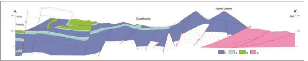
Figure 1 - Geological and structural sketch of the study area with location of the main
epicenters (updated September 25th 2016 – source INGV): 1) Quaternary continental deposits; 2) mainly arenaceous-pelitic bed- rock; Mesozoic-Cenozoic 3) mainly calcareous and marly calcareous bedrock; Miocene 4) Monte Vettore fault system; 5) main dip-slip and transverse faults; 6) main thrusts; 7) main DSGSD’s and large landslides (Aringoli et al
2016).
Figure 2 - Schematic cross section (see Fig. 1).: 1) mainly calcareous formations; 2)
marly calcareous formations; 3) calcareous and marly calcareous formations; 4) arenaceous-pelitic formations (Aringoli et al., 2016).
Since August 24th 2016, the central region of Italy, in particular Marche, Abruzzo, Lazio and Umbria regions, has been experiencing an important seismic sequence, involving an area of about 5000 km2 The first earthquake of magnitude 6.0, with epicenter located near the town of Accumoli (Rieti, Lazio), was followed by about 57,000 aftershocks and four other major seismic events of, respectively, 5.7 M, 5.9M, 6.5M and 5.7M ( respectively on October 26th, October 30th 2016 at about 19:10 and at about 21:30 on January 18, 2017).
Following the main event, checks were immediately carried out on the environmental effects of the earthquake, in particular those related to the reactivation of the fault system, hypothesized as the "earthquake faults", as well as on the secondary effects related to the main aftershock (e.g. landslides, fractures to soil, variations in the hydrogeological characteristics of the sources, sinkholes, etc.) in order to map and catalog all the evidence. Some of these studies have already been the subject of recent publications or scientific reports (Farabollini et al., 2016; Aringoli et al., 2016; Farabollini et al., 2017; Civico et al., 2018).
253
3. Geological and seismic characteristics of the area
The Castelluccio basin is an intra-mountain depression, located in the central Apennines and filled with fluvial-lacustrine sediments deposited during the middle Pleistocene up to the Holocene (Coltorti & Farabollini, 2002); the basal units are instead represented by micritic and pelagic limestones of Jurassic-Miocene age (Pierantoni et al., 2013 Fig. 1).
The main geomorphological modeling of the landscape began during the late Pliocene, when humid or subtropical climatic conditions, favorable to planning processes, created a low-energy paleo-landscape.
The following tectonic phase, active from the lower-middle Pleistocene up to now (AAVV, 2018), is characterized by dip-slip and oblique faults and by strong uplifts. The focal mechanisms refer generally to a distensive type, in agreement with the extensional tectonic regime to which is subjected the part of the Apennine chain where the earthquakes are located (AAVV, 2018).
These processes have interrupted and disarticulated the previous landscape, forming a series of tectonic depressions, such as Colfiorito, Castelluccio, Norcia, Cascia, Leonessa, etc., which characterize the entire Apennine area (Coltorti & Farabollini, 2002 cum bib.; Aringoli et al., 2016). The produced quaternary uplift, together with the stratigraphic arrangement, generated an intense morphodynamic activity that led to the significant remodeling of the previous landscape, also activating large landslides and DSGSD (deep seated gravitational slope deformation) (Aringoli et al., 2010); some of which showed evidence of reactivation during the current seismic sequence.
As for seismicity, two main historical and instrumental destructive earthquakes have been documented on January 14, 1703 (X MCS, Mw = 6.6) and September 19, 1979 (Ms = 5.9, focal depth of 6-8 km) although many others occurred over time, especially in the eighteenth century (Rovida et al., 2016), but with much smaller magnitudes, given the low degree of damage reported. Error data and focal earthquake mechanisms show a pre-existing NE-SW extension, but also certain strike-slip and reversal mechanisms (Cello et al., 1997). These historical earthquakes, including the recent one, have been associated with the activity of an active fault system operating in the NNW-SSE direction from Colfiorito to L'Aquila and interpreted as the superficial expression of deep seismogenic faults (Tondi & Cello, 2003).
The slope of Monte Vettore is characterized by the presence of two normal faults (Farabollini & GeomorphoLab, 2018): the lowest fault is present at the base of the Scarpata del Vettore and limits the Castelluccio basin. The upper
254
fault instead, passes very close to the summit of Mount Redentore, and is marked by a clearly visible escarpment over a length of about 7 km, commonly called "Cordone del Vettore" and also reported in the 1957 IGM cartography. In fact the western slope of Mount Vettore is the morphological expression of this SW-NNW-SSE (total length 30 km) tectonic immersion element, with northern termination at Mount Bove (Pierantoni et al., 2013).
4. Coseismic geological effects
Immediately after the events of August 24th and, subsequently, after those of October and January, the Geomorpholab Group of the University of Camerino, along with fellow geologists from Marche Region and from other Research Bodies (DPCN, INGV and ISPRA), moved across the territory in order to photograph, map, classify, catalog and computerize, via GIS platform, the innumerable evidences of surfaces related to the seismic shaking in the crater area. The direct effects are related to the deformation of the soil at the fault whose breaking has generated the seismic event. The effects are limited to an area that is not very extensive and close to breaking (Civico et al., 2018).
The secondary effects, resulting from the temporary passage of seismic waves, have also been identified very far from the epicenters, causing a widespread presence of permanent evidence on the earth's surface that, in relation to the length of the fault and the magnitude released by the event, have been estimated at thousands of km2 (AAVV 2018). More than 4000 evidences have been collected, which allowed to build a database on the effects of the earthquake, distinguished in direct effects and secondary effects (Farabollini et al., 2017): ground fractures, activation and reactivation of large landslides and DGPV, collapses of sinkholes; mud volcanoes and liquefaction phenomena, landslide dams, changes in the water regime of sources and the flow of rivers, fissure and / or fractures and / or deformations on road and on various infrastructures, and on infrastructure network, etc.
The observations on the geomorphological effects caused by the earthquake show a close correlation and casuistry with those that occurred during previous seismic events that affected the central Apennines, such as the Umbria-Marche seismic sequence (1997) or that of L'Aquila (2009), although the latter showed very minor and widespread evidence in a considerably smaller area (Farabollini & GeomorphoLab, 2018)
255
The main evidences found in the so called crater area (a recent Italian way to define the area hit by the earthquake) are reported below, in the attempt to describe, when possible and based on their morphogenetic and morphodynamic importance, the peculiar characteristics that distinguish them and allow them to be classified as coseismic effects.
1 - Reactivation of large landslides and deep slope gravitational deformations. In a previous study, Farabollini et al. (1995) have shown that about 500 large landslides and / or DGPVs have been identified in the Apennine, of which 200 fall within the area of the so-called crater of the seismic sequence of August 24th and later. The analysis conducted on the latter showed that about 25% of them underwent reactivation, both in terms of a general phenomenon and in terms of individual morphological elements.
In the area of Passo Cattivo, at the top of the Tenna valley, typical elements of deep slope gravitational deformations have been identified, which also had superficial sensations, always linked to gravity. In particular, on the crest of the Cima Vallinfante slope
- Monte Porche, a series of arched trenches are recognizable, parallel to each other and gradually of smaller size and extension proceeding towards the valley floor of the Tenna river, the most important of which cuts the top of the ridge itself, both on satellite images of August 4, 2013 and May 18, 2016, and which appear not to have been reactivated following the seismic event of August 24, 2016, but which instead have a width of about 2 meters and a depth estimated at about 1.5 m, after the seismic events of October 2016 (Fig. 3).
256
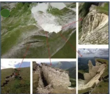
Figure 3 - Arched trenches on the Monte Porche.
After the seismic events of October, extensive landslides were reactivated, above all, rock collapses and avalanches, present in the mid-summit portion of the Vallinfante slope, creating vast detritus cones at the base of the slope itself and producing a clear retreat of the main slope, with tension fractures aligned according to the arched shape of the landslide scarp itself, with detachments, rocky pinnacles and protruding blocks; furthermore, these materials could also be re-mobilized as a result of the cryoclastic action given both by the strong fracturing that pervades the rock mass and by the calcareous nature of the rock mass itself and its slightly friable hilly characteristics.
The morphological elements mentioned above allow us to assume the presence of a deep gravitational deformation (DSGSD) which affects the highest part of the slope with a depth of some hundreds of meters and partially covered by debris deriving from collapse landslides and debris-flow like processes - that continuously occur throughout the area (Farabollini & Spurio, 2008). The genesis of this phenomenon, which can be defined as a deep rock creep, can be associated with the high energy of relief generated by the quaternary tectonic uplift, by the important and pervasive interaction between the Monte Vettore fault system and the Sibillini Mountains overthrusting (Aringoli et al., 2016) and by the strong fracturing of the rock mass.
257
2 - Rock collapses and / or debris avalanches: They are mainly present along slopes in places that are not very steep, affecting anthropized and non-populated areas (Montegallo, Monte Vettore, Valnerina, Sasso Spaccato). In some cases these phenomena have also caused barriers in the rivers’ flow, with the creation of shallow and temporary lake basins (Valnerina; Gola dell'Infernaccio);
3 - avalanches: on the south-east slope of Mount Sibilla - Monte Porche and Monte Bove connected with the snowfall type of December and especially on 6 January and later on 16-19 January 2017, followed by major seismic shocks (18 January 2017); to this end, the evidences of avalanche activity probability due to seismic activity of the shocks at 10.33 local time in Montemonaco and Bolognola- Pintura, were reported on models 1 of the State Forestry Corps - Meteomont Service -.
4 - activation and / or reactivation of persistent superficial landslides on road and network infrastructures of the “crater” area (Fig. 4) of even considerable dimensions;
Figure 4 - Landslides on the road, triggered by the EQ.
5 – Structural failure and / or collapse, formed on the Pian Grande of Castelluccio for the reactivation of one of the numerous sinkholes present in the plain, with a sinking of about 4 meters and for a width of about 5 meters;
258
6 - liquefaction phenomena and mud volcanoes identified respectively near the industrial area in Caldarola and in the Curetta di S. Vittoria region in Matenano;
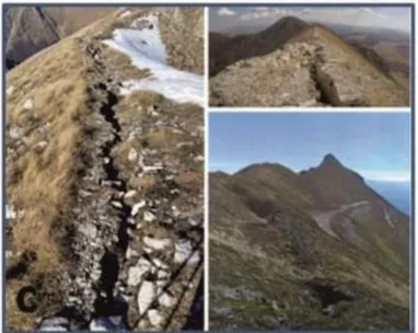
7 - fracturing and / or ground cracks (Fig. 5) which have widely affected the entire epicenter area: for the former, certainly the most extensive, it is worth mentioning those present along the ridges extending from Mount Porche - Cima Vallelunga - Mount Argentella, to Monte Sibilla or Monte Fema, for an estimated length of over 3 km; for the latter, on the other hand, the assessment of the deformation effects makes it possible to estimate the amount of infrastructures (roads) involved in these effects at nearly 1200 km.
Figure 5 - Fracturing and ground cracks.
8 - Soil deformations mainly related to sedimentation and / or compaction of the Quaternary sediments to which the high degree of damage to infrastructures and inhabited centers (Pescara del Tronto, Piedilama, Pretare, Amatrice, etc.) and the numerous deformations of road and / or network infrastructures must be attributed.
The situation of the Pescara del Tronto hamlet is worth to be mentioned: the geomorphological analysis, both in the countryside and in aerial photography, and the detailed analysis of both the pre-quaternary substrate and the Quaternary sediments filling the Tronto valley and of their geometrical and stratigraphic characteristics, allowed to highlight a much
259
more complex picture compared to what was expected on the basis of simple surface observation or deriving from analysis of the local seismic response of soils.
The total collapse of the built-up area of Pescara del Tronto, compared to the strong damage verified in Capodacqua village, located a few km from the first, is due to the high heterogeneity of the quaternary deposits, given by the considerable thickness of continental sediments, differently organized and cemented, and its strong lateral and vertical variations of facies, shifting from stratified debris deposits to chaotic deposits of extensive landslide bodies, up to travertine deposits of “cascade” facies, interdigitated to deposits in "cascade and tub" facies.
The wide area of distribution of the coseismic effects and their widespread variability and frequency, made it possible to understand how the causes of the high heterogeneity of the effects on the physical environment and of the strong diversity, with the same structural characteristics of the buildings, of the damage is attributable to a very articulated geomorphological context, also given by buried morphologies that sometimes fall only outside the field analysis and can be solved through acquisition of data deriving from specific geostatical surveys (AAVV, 2018).
Finally, as regards the presence of fractures with an arcuate curve, circular depressions and circoid morphologies, in areas of low or no significant energy, which has also conditioned, in places, the anthropization of the territory, both in the infrastructures and in the agricultural activities, it has been related to the presence of dolines and / or sinkholes, both on quaternary deposits (Pian Grande di Castelluccio) and on calcareous substrate (Monte Bove- Monte Porche-Monte Sibilla).
These morphologies, linked to karstic processes that have affected the calcareous substratum of the area affected by the earthquake, are very often masked by quaternary filling deposits, and can only be recognized by careful geomorphological analysis from aerial and countryside photos. In all likelihood, the different presence and heterogeneity of behavior, both of ground fracturing and damage, can find a wide explanation precisely in the presence of such manifestations, as amply demonstrated by the evidences related to the 2009 L'Aquila seismic crisis (Farabollini et al., 2012).
9 – Changes in the range of some sources. During the seismic sequence, important variations in the water regime of the sources present in the crater area were highlighted. In fact, important flow rates have been reported for almost all the "deep" sources in the epicentral area (source of Pescara del Tronto, Capodacqua and Foce di Montemonaco) fed by the aquifers of the
260
Piani di Castelluccio and Monte Vettore areas. The range increases even by several tens of liters / second, as in the case of the San Chiodo source of Castelsantangelo sul Nera (in the hours following the earthquake) and / or temporary alterations of the chemistry with sporadic increases in water turbidity. In some cases, even the "disappearance" of the source itself occurred, as in the case of the Forca Canapine source in the Ascoli area, which disappeared after the earthquakes of 26 and 30 October 2016 (which contributed with a flow rate of over 50 l / s to the 'water supply of the municipalities of Fermano and Piceno) (Aringoli et al., in press).
Perhaps the most striking example is that of the source of Torbidone, in the municipality of Norcia which disappeared after the earthquake of 1979 and was reactivated after 30 October 2016 with a flow that gradually increased until reaching, at the beginning of February, about 2000 l / s.
5. Coseismic database
The Marche Region is among the few regions to have total coverage of extremely detailed geological information, largely deriving from the effort made to contribute to the Geological Map of Italy at the scale of 1: 50,000 — CARG Project (CARG, 2019; Servizio Geologico d’Italia, 1995) and, thanks to a memorandum of understanding with the Emilia-Romagna Region, the Umbria Region and the Tuscany Region, the Marche Region is now planning the realization of a territorial continuum at the 1: 10,000 scale resulting from a complex homogenization work. These data are therefore being integrated into a specific relational database for geological mapping covering the entire territory of the four Regions; from this database, specific theme can be extracted as needed, to support planning, design, analysis and research.
Thanks to some dedicated projects (CARG, 2019) most of the surface of the Marche Region is also covered by geomorphological data that are equally detailed and are also organized in a local database. With this in mind, a project to gather new information following the recent seismic crisis had necessarily to be designed taking into account the needs of computerization, georeferencing and interrogation in relation to existing data (Angelini, 2014); at the same time the vastness of the topic of the coseismic database and the multiplicity of possible inputs and signals suggested an agile interface, with the possibility of a continuous evolution and updating and with opportunities for extremely simplified visualizations and queries. The first phase of the creation of a database consists in the identification of the entities and of the
261
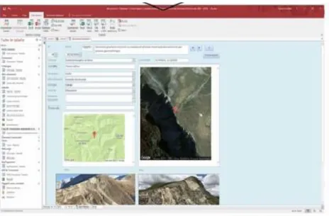
knowledge domain to be described and in defining its relationships (Servizio Geologico d’Italia, 1995). The new data collected were therefore organized in an easily editable local entity / relationship type database that, through the overall evaluations over the next few months, could suggest specific research topics, indicate criticalities and suggest updates in the existing cartography (Fig. 6).
Figure 6 - Display of the local database.
The data have been inserted as punctual features, equipped with a progressive and univocal identifier (ID) within the territorial domain, thanks to the WGS'84 decimal coordinates; this domain is made up of the areas affected by the 2016-2017 seismic sequence. Each recorded information maintains the essential characteristics of the phenomenon among its attributes and refers to external links for the type of observation and for auxiliary information. The database uses concepts of entities / relationships to correctly manage the geographic (topological) and information (attributes) related to real mapped objects: this is how some information levels are defined, within which geographic features are stored based on "families" of encoded data; the other data may or may not be linked to the analysis in progress depending on the aspect to be highlighted (Angelini et al., 2013) (Bourrogh & McDonnel.1998)The application offers a simple, operational interface, within which there are spaces for signaling transient elements and free notes, as well
262
as a series of menus for unambiguous identification of the emergency. The interface mask translates the codes used to store the information, so as to make it usable even when a local database is not available.
At the inserted point of interest, some specific external tabular information has been linked, about the lithology of the lands involved, the geomorphological scenario in which the form or process reported and, in order to make immediate identification, extracts of Google maps, punctual and / or panoramic images.
The forms compiled according to the architecture described above, can however be used both for the construction of a new platform integrated with geological and non-geological spatial data, and for the continuous updating of the database, and for the monitoring of morphodynamic and morphogenetic aspects.
6. Final observations
The analysis of the numerous evidences found in the area of the so-called "crater" has allowed us to estimate that about 70% of the effects found are attributable to fractures and coseismic cracks; that about 8% are due to landslides S.L. and to deformations, while about 20% to failure of road and network infrastructures and the remaining 2% to failure, variations in the water regime and other minor causes. The GeomorphoLab is working on the realization of more detailed analysis of the data, however, it should be pointed out that the database is certainly not complete as some situations more or less limited and not very evident have not been taken into consideration, including the long seismic sequence that generated earthquakes of more than 5M from August to January 2017, that has often amplified and superimposed effects already produced with the first shock on 24 August, making it sometimes difficult to acquire the data.
In the area affected by the long seismic sequence, the geological survey shows the presence of numerous quaternary faults (AAVV, 2018) all with indications of recent activity. On the basis of their dimensions, it is possible to attribute a seismogenic potential up to 6.5Mw. Along many of these faults there have been superficial phenomena that in some cases have rejuvenated the rock slope and / or faulted soil, with freeface rated up to 1 m (Monte Vettore).
The problem that arises is therefore that of the suitability of the resolution of the geological analysis for the evaluation of the seismic hazard of an area:
263
in fact, on the basis of considerations on the return times of the strong earthquakes of the central Apennines, Norcia fault could have been reported as the seismogenic fault, rather than thinking of the other faults which, however, have very evident morphological expressions (Vettore fault, Monte Bove fault, Campotosto fault, etc.) (Farabollini & GeomorphoLab, 2018).
Similar to the purely geostructural aspect, it is necessary to take into consideration the geomorphological effect on the environment and on the damage, trying to verify and, above all, quantify the role of some geomorphological elements that characterize the central Apennine territory, and in particular the role played by the large landslides in the quiescent state or the Deep Gravitational slope Deformations, in determining effects of local amplification both in bedrock and in the continental Quaternary deposits. In this way, based on the effects on the soil and on the damage to the buildings, it would also be possible to effectively locate the epicenter areas, especially for those defined by historical data.
In parallel, we'd like to point out that it is essential to address some themes, so far considered as related to different branches of knowledge. The recent seismic events in the center of Italy have once more highlighted two of the most dramatic lacks in the field of territorial management of our country: the infrastructure maintenance and the prevention. The reconstruction is a complex and delicate action too, more difficult due to criticality in the cultural approach. The mainstream culture rarely takes into consideration geology, as if the study of earthquakes and the reconstruction projects should be related just with engineering and architectural issues. The problems related to the geological hazard of the territory, the so-called site effects, the relationship between the substrate, its natural evolution and buildings: all these are not adequately considered. Geology should not be relegated to a subsidiary role in spatial planning: the response of territory (intended as the integration of nature and culture) to natural events derives precisely from its geological structure, its evolution, its transformations as well as from the social consciousness of such concepts.
Referring to the need to reason about the slogan "as it was, where it was," divulged by mass media as a promotion for a reconstruction that respects the historical value of the destroyed sites, it would be desirable to base projects and actions on a multidisciplinary approach. Teams including experts from various fields of expertise, are complete where geologists, geotechnics, geophysicists, hydrogeologists, architects, engineers, and jurists, economists, sociologists, psychologists, should collaborate in a synergic and complementary way.
264
It is essential to highlight that doing a good job does not mean working slowly: the post-earthquake management must be speeded up to give answers to the inhabitants of the affected areas. Eradicating citizens from their place of residence for a too long time, causes dramatic consequences, such as the abandonment of places and the loss of culture. It would be right to bring the communities back to live in safety in their “places of the heart”; the communities have to be rebuilt even before the houses. For this purpose it is needed to start a dialogue with individual/community/society living the territory and policymakers, aiming at creating synergy and empathy: reconstruction can start and go on, following this way. Moreover, it is mandatory a stronger development in the field of communication, by sharing information, in the aim at starting a social risk consciousness and strengthening risk prevention.
An essential basis to deal with land management, both in terms of risk prevention and in the emergency and post-emergence phases, is the knowledge. The study of geological and geomorphological settings is mandatory to analyze the territorial context, as well as its possible evolution in case of seismic events. Such information should be the foundation of each territorial planning policy, giving the technics -and the whole society- those criteria to be followed in order to ensure adequate, sustainable and safe lives for individuals/communities/society.
References
AAVV, 2018, Le attività del Servizio Geologico d'Italia (Ispra) a seguito della sequenza sismica del 2016-2017 in Italia Centrale. June 2018, Geologia
dell’Ambiente - Italian Magazine of Environmental Geology
XXVI(1/2018):117-135
Angelini S., 2014, Banche dati e geomorfologia: esempi e applicazioni a partire da dati CARG. Atti del Convegno, Dialogo intorno al paesaggio, I, pp. 25-36.
Angelini S., Farabollini P., Menotti R.M., Millesimi F., Petitta M., 2013, “Application of the compurised cartography to the territory management: the geomorphological map of palaeolandslides in the Velino River Valley”.
Landslide Science and Practice, Spatial Analysis and modeling, Springer, III, pp. 415-421.
265
Aringoli, D., Bufalini, M., Farabollini, P., Giacopetti, M., Materazzi, M., Pambianchi, G. & Scalella, G. (in press), Effetti geomorfologici e variazioni idrogeologiche indotti dai terremoti: esempi nell’area epicentrale della sequenza sismica 2016-2017 del centro Italia. Atti Conv. Sigea, Preci, 2017.
Aringoli, D., Farabollini, P., Giacopetti, M., Materazzi, M., Paggi, S., Pambianchi, G., Pierantoni, P.P., Pistolesi, E., Pitts, A. & Tondi, E., 2016, “The August 24th 2016 Accumoli earthquake: surface faulting and Deep-Seated Gravitational Slope Deformation (DSGSD) in the Monte Vettore area”, Annals of Geophysics, 59(5), https://doi.org/10.4401/ag-7199.
Aringoli, D., Gentili, B., Materazzi, M. & Pambianchi, G., 2010, “Mass movements in Adriatic Central Italy: Activation and evolutive control factors”. In: Werner, E D. and Friedman H.P., Eds., Landslides: Causes,
Types and Effects, pp. 1-72.
Bourrogh, P.A. & McDonnel, R.A., 1998, Principles of Geographical
Information Systems. Oxford University press.
CARG Project, 2019, http://www.isprambiente.gov.it/it/progetti/suolo-e-territorio-1/progetto-carg-cartografia-geologica-e-geotematica; accessed on 09.09.2019.
Civico, R., Pucci, S., Villani, F., Pizzimenti, L., De Martini, P.M., Nappi, R. & the Open EMERGEO Working Group, 2018, “Surface ruptures following the 30 October 2016 Mw 6.5 Norcia earthquake, central Italy”,
Journal of Maps, 14(2), 151-160, https://doi.org/10.1080/174 45647.2018.1441756.
Coltorti, M. & Farabollini, P., 2002, “Quaternary evolution of the Castelluccio di Norcia Basin (Umbro-Marchean Apennine, Central Italy)”. Il
Quaternario, 8 (1), 149-166.
Farabollini, P., Folchi Vici d’Arcevia, C., Gentili, B., Luzi,, L., Pambianchi G. & Viglione F., 1995, “La morfogenesi gravitativa nelle formazioni litoidi dell’Appennino centrale”, Memorie della Società
Geologica Italiana, 50, 123-136
Farabollini, P. & Spurio, E., 2008, 2Applicazione dei GIS nello studio dei fenomeni di debris flows dell’appennino umbro-marchigiano (Regione Marche, Italia)”, Rendiconti Online della Società Geologica Italiana, 2, 1-9. Farabollini, P., Aringoli, D., Materazzi, M., Pambianchi, G., Pierantoni, P., Scalella, G. & Tondi, E., 2012, “Il terremoto aquilano del 6 aprile 2009: rilievi geologici, geologici del Quaternario e geomorfologici e considerazioni per la prevenzione del rischio sismico e per la ricostruzione post-terremoto”.
266
Farabollini, P., Aringoli, D., Materazzi, M., Pambianchi, G. & Scalella, G., 2017, Large Landslides and Deep Seated Gravitational Slope Deformation triggered by the 2016-2017 central Italy seismic crisis: first evidences from the Mount Vettore-Mt Bove epicentral area. Abs. Int. Workshop “From 1997 to 2016: Three destructive earthquakes along the central Apennine fault system, Italy”. July 19-22, 2017.
Farabollini, P., Angelini, S., Fazzini, M., Lugeri, F.R., Scalella, G. & GeomorphoLab, 2018, “La sequenza sismica dell'Italia centrale del 24 agosto e successive: contributi alla conoscenza e la banca dati degli effetti di superficie”, Rendiconti online della Società Geologica Italiana, 9-15. DOI: https://doi.org/10.3301/ROL.2018.45
Pierantoni, P., G. Deiana, and S. Galdenzi, 2013, “Stratigraphic and structural features of the Sibillini Mountains (Umbria-Marche Apennines, Italy)”. Ital. J. Geosci., 132(3), 497-520.
Servizio Geologico d’Italia, 1995, Linee guida della Carta geologica
d’Italia alla scala 1:50.000, Quaderno n. 6, Guida all’informatizzazione. Ed.
Ist. Poligraf. e zecca dello Stato.
Tondi, E. & Cello, G., 2003, Spatiotemporal Evolution of the Central Apennines Fault System (Italy), Journal of Geodynamics, 36, 113-128.