Na’hjeNing’e’s Rivers
Indigenous Maps, Diplomacy, and the
Writing of Ioway Space
byFrank Kelderman
ABSTRACT: This essay examines an indigenous map (1837) of the Missouri and Mississippi river valleys, which offers an alternative to the territorial mappings of US empire in the era of Indian removal. The map was presented by the Ioway delegate Na’hjeNing’e during an intertribal treaty council in Washington in 1837 and depicts the Ioway Nation’s historical occupation of large areas in the Mississippi River Valley. Although the American treaty commissioners ultimately dismissed the map's historical argument and the Ioway's claims, its visual presentation of rivers and indigenous migrations routes marked an alternative to US territorial mappings of Indian country. Understanding the Mississippi River Valley as a site of territorial contestation, Na’hjeNing’e’s visual rhetoric took Ioway migrations along these waterways seriously as a basis for indigenous land claims and sovereignty, presenting an alternative to the settler state’s mappings of Native space. At the same time, the imbalance of power relations within American bureaucratic networks meant that the map is an example of disrespected literature: a form of indigenous writing that was legible within colonial settings, but nevertheless disregarded because it did not align with settler-colonial projects of indigenous dispossession. By considering the diplomatic calculations behind it, this essay argues that Na’hjeNing’e’s map asserted a representation of Ioway sovereignty, but also reveals the bounds on that sovereignty at a moment when removal policy and settler expansion profoundly reshaped the social and political place of Indian nations in North America.
KEY WORDS: Native American; cartography; Indian diplomacy; settler colonialism; indigenous sovereignty; Ioway history
INTRODUCTION
In 1837, at a treaty council in Washington DC, delegates from the Ioway Nation presented American treaty commissioners with an elaborate river map of the Midwest and the eastern Great Plains. Drawn in ink, the map depicts the Ioway people’s historical occupation of villages along the Mississippi and the Missouri rivers, as well as tributaries including the Des Moines, Iowa, Illinois, Big Sioux, Wisconsin, and Rock rivers. Presenting an overlay of rivers, lakes, migration routes, and village sites, the Ioway map is a remarkable document that charts indigenous migration and settlement over two centuries, from 1600 to the 1830s. In the long history of indigenous writing in North America, the 1837 map stands out as an arresting image of the political and social life of the Ioway people in the heart of the continent.
For scholars of indigenous literature and culture, the Ioway map of 1837 offers insight into the multimedia practices that were central to US-Indian interactions in the nineteenth century. Historians have often attributed the map to the Ioway diplomat Na’hjeNing’e (“No Heart of Fear,” 1797-1862), who presented the document to American agents in 1837, during intertribal negotiations over land and treaty rights. As a visual text that originated in a colonial situation, the Ioway map points to the performative context of what Matt Cohen and Jeffrey Glover call “colonial mediascapes”: the complex interactions of textual and non-textual materials that formed the basis of communication between Native people, settlers, and other newcomers in the early Americas (5-7). A collaborative text, the Ioway map reflects how indigenous communities in the Americas made their own histories legible within the bureaucratic discourses of the settler state. By navigating colonial institutions to address the impact of settler expansion, Native American diplomats such as Na’hjeNing’e entered the written record in fraught historical circumstances, but their writings and oratory also challenged the policies and ideologies of US governmental agencies. As a visual record of such communicative practices, Na’hjeNing’e’s map represents the Ioway people’s historical movements and territorial claims while challenging colonial narratives of an “empty continent” that awaited European settlement.
But to what extent was Na’hjeNing’e’s map legible to US administrators who had a concrete political stake in disavowing its interpretation of indigenous space? The map articulated the Ioway’s territorial claims in ways that were entirely legible to the US state, but American treaty commissioners easily disregarded the treaty rights the Ioway delegates sought to secure. In this respect, the 1837 Ioway map is also an index of fundamental power imbalances within diplomatic networks. Although the conduct of US-Indian diplomacy gave rise to a long tradition of indigenous political writing and oratory, American officials could afford to disregard the territorial claims of smaller Indian nationslike the Iowaywhen this proved convenient for the geopolitical calculations of the settler state. If the 1837 map shows the Ioway nation’s expansive historical presence in the Great Lakes and eastern Great Plains, its reception testifies also to the Ioway’s diminished power within scenes of US-Indian relations.
Na’hjeNing’e’s map thus represents a prime example of disrespected literature, since colonial agents ignored the historical claims that the map presented, not in the least because of the Ioway people’s diminished geopolitical influence. In this essay, I
examine the 1837 Ioway map to consider how forms of indigenous writing were disrespected within institutions of US-Indian diplomacy. I argue that in order to make a visual document such as Na’hjeNing’e’s map meaningful in critical discourse and as a pedagogical tool, scholars need to attend to the ways in which it resisted the colonial mappings of Indian country, while also recognizing that its visual rhetoric and political implications were shaped by the dynamics of the diplomatic situation that produced it. By considering the diplomatic calculations underlying the 1837 map, we may recognize how Na’hjeNing’e’s map asserted a representation of Ioway sovereignty, but also reveals the bounds on that sovereignty at a moment when removal policy and settler expansion profoundly reshaped the social and political place of Indian nations in North America. If colonial agents disregarded the map at the moment of the treaty, the scholarly reappraisal of Na’hjeNing’e’s river map, I argue, demands a wide-ranging account of the limits and possibilities of Indian diplomacy that shaped its mapping of indigenous space.
DIPLOMATIC WRITING AND THE MAKING OF THE IOWAY MAP
Na’hjeNing’e’s 1837 river map was by no means an anomaly in the long history of indigenous cartography, which has been explored by scholars such as Barbara Belyea (1992), Margaret Pearce (1998), and Mark Warhus (1997). Indigenous maps were a common recourse in indigenous-settler interaction in the nineteenth century, and G. Malcom Lewis notes that “maps were solicited from Indians on almost all the great post-Lewis and Clark surveys of the American West” (“Frontier” 23). Historian David Bernstein, too, traces the multimedia forms indigenous leaders used to represent indigenous space to other diplomats and US agents, not only through writing but also through gesticulation, oratory, drawings in the sand, and boundary markers in the landscape (17-19; 25-27). The 1837 map was used during an intertribal treaty council organized by the US Commissioner of Indian Affairs, Carey Allen Harris, who brought more than a hundred delegates from the Sauk, Meskwaki, Sioux, and Ioway nations to Washington. Historical sources are inconclusive on the question of who drew the 1837 Ioway map, but it is annotated with a note stating that it was “made by an Indian, and presented to C. A. Harris […] on the part of the U.S. by ‘Non-chi-ning-ga’ an Iowa Chief.” For this reason, the map is often attributed to the Ioway leader Na’hjeNing’e or No Heart, who came to Washington as the main Ioway delegate in the place of his brother, the tribal leader White Cloud (Olson 69). As a diplomat, Na’hjeNing’e took an accommodationist stance on the tribe’s relationship with the United States and become known as a “consistent leader who could reliably be counted on to support the agenda of the white missionaries and government agents” (Olson 69).
Although it is often referred to as “No Heart’s Map,” Mary Kathryn Whelan notes that there is no reason to assume that Na’hjeNing’e created the map himself (27). More likely, it was drawn up for the Ioway delegates by a draughtsman of the Indian Officeperhaps at the behest of the Indian agent Andrew Hughes at the Great Nemaha Agencyand was based on directions from Na’hjeNing’e and other Ioway informants. The publication of Na’hjeNing’e’s map was thus a collaborative effort that enlisted Ioway memory and story-telling as well as the agency of colonial
interlocutors. In this aspect, its creation echoes the wider practice of Indian diplomacy, which typically worked by scripted and ceremonial routines such as oratory, parades, gift-giving, and tobacco smoking, and which blended indigenous and Euro-American protocols.
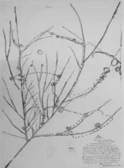
According to a brief annotation on the map, Na’hjeNing’e presented the Ioway map on October 7, 1837, during council proceedings that were held at a Presbyterian church in Washington (Ioway Map 1837). The map depicts the Ioway’s historical villages and migration routes, which are carefully drawn out in a landscape of rivers and lakes (see: Fig. 1).
Fig. 1. Ioway map of the Mississippi and Missouri River Valley, c. 1837. Record Group 75, Map 821. National Archives and Records Administration, Cartographic and Architectural Branch, College Park, MD. The annotations on the map—written by a Bureau of Indian Affairs official in 1884—are as follows: “This map accompanied the Journal of proceedings at a Council held in this city with a delegation of Chiefs and Braves of the Confederated Tribes of the Sac and Fox Indians of the Mississippi, and a delegation of Sac and Fox and Iowa Chiefs and Braves of the Missouri October 7, 1837 at 10 o’clock A.M. It was made by an Indian and presented to C. A. Harris, Esq. comr. On the part of the U.S. by ‘Non-chi-ning-ga’ an Iowa Chief who produced and referred to it during his address at the Council, as appears on pages 46 and 47 of the journal.”
The longest line that runs from the bottom left to the center-top of the map represents the Mississippi River; the long line branching off from the Mississippi near the bottom-left represents the Missouri River. On the east side of the Mississippi we see (from top to bottom) the Illinois River, the Rock River, and the Wisconsin River. Between the Mississippi and the Missouri, it shows the Des Moines, Iowa, and Cedar River, among others. And to the west of the Missouri, it shows the Platte River near the top left of the map. The empty circles without dots in them represent lakes—probably those that were most important to Ioway economic life. Within this landscape of rivers and lakes, Na’hjeNing’e mapped out the Ioway’s historical presence in the Midwest and the eastern Great Plains: the dotted circles represent populated villages at different moments in their history, while the dotted lines show their historical
migration routes. Through these means, the Ioway map charts the Ioway’s deep historical and geographical knowledge of the region, by locating their traditional homelands near Green Bay ca. 1600 and by tracing their migrationsover the next two and a half centuriesthrough the woodlands in present-day Wisconsin and the plains of present-day eastern Nebraska.
In the absence of alphabetic annotations, the map itself does not display detailed information about the chronology of these migrations: they are marked by dotted lines but there are no obvious signifiers of the order of historical movements or settlements. As G. Malcom Lewis puts it, “apparently lacking a beginning or an end, the dotted line zigzags across much of the western Middle West,” covering “more than one quarter of a million square miles” (“Frontier” 13). Yet the map does offer some measure of historical focus. Since it depicts the inter-riverine region between the Mississippi and Missouri rivers in most detail, the map perhaps emphasizes the period from about 1780 to 1824, when the Ioway claimed a prominent hold in the region around the Des Moines River and Iowa River.
Nevertheless, the map embeds this period in a longer history of Ioway presence in the region, by tracing migration routes that dated back to the early seventeenth century. As a result, the lines, circles, and dots on Na’hjeNing’e’s map write a history of what is simultaneously Ioway migration and Ioway presence: although it offers a historical account of change and migration, it nevertheless does not place the legitimacy of their territorial claims in the past. By taking seriously the migration routes of Ioway life as a basis for indigenous land claims and sovereignty, the map locates an alternative to US territorial mappings of Indian country that had delegitimized Ioway claims to the land. Adam Jortner argues that the “dominant cartographic model is the empty continent” (75), in which the borders of American states and territories render US empire as “a settled state of affairs” (Jortner 73). The historical scope of Na’hjeNing’e’s map disrupts the rhetoric of the empty continent and offers an alternative to the teleology of European empire. By tracing Ioway migration patterns that followed the flow of rivers, it challenges the notion that migration and mobility marks Indian nations as having only a “transitory” presence. This recognition of the history of Ioway migration and settlement drew on deep and precise geographical knowledge that was passed down orally. In this respect, the Ioway map extends what Whelan calls a “centuries-old tradition” of Native American “spoken maps”; texts that were constructed and disseminated orally and blended “natural and cultural information” (8).
But if Na’hjeNing’e’s map incorporates Ioway community knowledge, it also conforms to Euro-American conventions of map-making: it is “based on a mixture of traditional Ioway symbolism, more widely shared pan-Indian iconography, and symbolic elements borrowed from western cartography” (Whelan 4). The delegates blended traditional methods with “elements familiar to them from western maps of the time,” turning to technologies of writing that they imagined “would be compelling to their EuroAmerican audience” (Whelan 8). Indeed, David Bernstein argues that the Ioway map “demonstrates creative geopolitical tactics that defy easy categorization in a historical period that is frequently depicted in black and white—or, in this case, red-and-white—terms” (41). It would be too simplistic, therefore, to claim that its creation “demonstrated the Iowas’ replacement of an epistemologically ‘Indian’ way of
representing the eastern prairies with a uniquely ‘Euro-American’ one” (Bernstein 54). As Bernstein further notes, the Ioway map differs from traditions of indigenous map-making in another crucial aspect: it follows the European model of “spatial equivalence,” in which the scale does not depend on the distance from particular locations, as was more common in Native American maps, but on “a constant scale with the familiar perspective ‘from above’” (51). Moreover, by using the map to delineate their territorial claims, Bernstein observes, the Ioway delegates “demonstrated their understanding of Euro-American territoriality” (52). Rather than claiming the map as a wholly Ioway or indigenous representation of space, we should consider its visual rhetoric in relation to the diplomatic situation that was the occasion for its publication. Na’hjeNing’e’s map cannot be understood as a radically alternative depiction of the region through an authentically Ioway perspective; the collaboration of Ioway leaders and US agents had a profound influence on its representation of Ioway history and territory.
THE BOUNDARIES OF INDIGENOUS SOVEREIGNTY
Na’HjeNing’e’s map thus emerged from negotiations that shaped US-Indian diplomacy in the nineteenth century. A main goal of the 1837 council was to settle border disputes that were causing frequent hostilities between the Minnesota Sioux and the Sauk and Meskwaki nations (Viola 34). For the Ioway delegates the council was an opportunity to seek remuneration for lands that their nation had been dispossessed of in the preceding decades. The Ioway had previously inhabited present-day Iowa, but by 1837 they had been forced to remove to an area surrounding the Great Nemaha Agency, near Fort Leavenworth in present-day Kansas (Olson 14-15). During the 1837 treaty negotiations in Washington, the Ioway delegates addressed the fact that their historical homelands in the Mississippi River Valley were now occupied by the Sauk and Meskwaki nations, who in turn were being pressured to sell large tracts of it to the United States. The Ioway delegates argued that because the Sauk and Meskwakis’ had previously taken these lands from them, the Ioway people deserved monetary compensation for any sale of these lands to the Americans (Olson 123). The case of the Ioway thus reflects that US-Indian diplomacy was intimately tied to the policy and practice of indigenous dispossession, which played out in a complex intertribal context.
That Na’hjeNing’e’s map was a form of diplomatic writing, however, is not to suggest that it was simply over-written by colonial understandings of the territory. Although we cannot locate in the map a singularly Ioway understanding of space, Na’hjeNing’e’s map undoubtedly advanced an Ioway political project. For the Ioway delegates, the concrete goal of their river map was to decenter the territorial claims of the Sauk and Meskwaki delegates to this very region. When Na’hjeNing’e presented his map of the Mississippi-Missouri region, this visual text dovetailed with oratory and performance that defended the Ioway’s claim to the contested lands between rivers. This brought the Ioway delegates at odds with the Sauk and Meskwaki delegatesin particular the Sauk civil chief Keokukwhose people now occupied large areas in present-day Iowa and were pressured to sell significant tracts of it to the United States.
Such diplomatic interactions were an important context for Native American writing and oratory, since they afforded opportunities for Native speakers to represent their communities in public discourse, in self-consciously politicized ways. Understanding the Mississippi and Missouri River Valley as a site of territorial contestation, the map challenged the Sauk and Meskwaki people’s claims to this region, and thereby also the undergirding logics of conquest by which the United States validated these claims.
If this perspective was rooted in Ioway knowledge of the landscape, it was also a product of the diplomatic situation. Mary Kathryn Whelan notes that the map was “a contemporary product,” which was “generated as a rhetorical tool to help persuade U.S. government officials during treaty talks” (8). The 1837 Ioway map is therefore a reminder that diplomatic interactions were shaped by intense negotiations over histories of settlement and dispossession, as well as financial negotiations over land sales and annuities. Such diplomatic interactions worked by a schematic, even simplified representation of Indian nations. As Geörgy Fredric Tóth puts it, in diplomacy “the category of the nation is not natural but performed”:
Diplomacy is the performance of the ‘nation’ through ‘representation’ – the standing in of an individual or a team for the interests and positions of a larger ‘imagined community.’ Diplomacy performs the imagined community through the metonymy of the ‘diplomat’ representing the whole of their country. (15)
In other words, Indian diplomacy depended on strategic acts of national self-representation, which pursued what James H. Cox calls the “patient, tactful advocacy of an idea, a policy, or a plan” (112). In this sense, Indian diplomacy is an overtly political form of cultural mediation: it is defined by self-consciously political moments of interaction and there is an “end game” for all sides involved (112-3).
However, diplomatic negotiations such as the 1837 delegation were also part and parcel of how settler colonialism elaborated in North America. Briefly put, settler colonialism is a form of colonialism in which the structuring imperative is not the domination of native labor (as is the case in extraction-based colonialism) but the extinguishing of indigenous presence and land title. In Patrick Wolfe’s influential formulation, settler colonialism is “an inclusive, land-centred project that coordinates a comprehensive range of agencies, from the metropolitan centre to the frontier encampment, with a view to eliminating Indigenous societies” (393). In North America, settler colonialism follows what Carole Pateman calls the “tempered logic of the settler contract,” as distinguished from the “strict” logic. Under the strict logic, settlers do not recognize the sovereignty and land title of indigenous nations but render their lands “vacant,” thereby relinquishing the need to make treaties with them. The United States, however, upheld the “tempered logic” of settler colonialism, in which the settler state and Indian nations made treaties that were part and parcel of how indigenous land title was extinguished (46-53). In other words, under this tempered logic of settler colonialism, the government did recognize indigenous sovereignty and indigenous dispossession operated through such diplomatic negotiations as the 1837 treaty council.
The delegation to Washington was thus an important opportunity for the American government to further elaborate the work of indigenous dispossession: as US agents negotiated land cessions in exchange for annuity payments, they extended
a centuries-old pattern of settler colonialism. Yet this colonial situation does not entirely foreclose any anti-colonial register in Na’hjeNing’e’s river map. As Lorenzo Veracini notes, the settler colonial situation demands that indigeneity is imagined in terms of “fragility” (4), meaning that the settler-colonial imaginary pitches Native people as soon-to-be-vanished, conquered, assimilated, nomadic, or simply gone. Against a colonial narrative in which indigenous land claims are only temporary and bound to be superseded by the settler state, the Ioway map asserts a more robust link between Ioway nationhood and geographical territory. Even though Na’hjeNing’e’s map privileges the flow of rivers over tribal boundariesand historical migration over fixityit still projects a spatially bounded vision of the region to mark it as Ioway space. In the first place, it leaves out any reference to the historical presence of other Native communities, in particular the Sauk and Meskwaki people. Moreover, the map’s visual organization reifies the Ioway’s claim to geographical space and promotes a relatively fixed idea of the relation between nation and territory, one that was amenable to the logics of the administrative state. For instance, G. Malcom Lewis suggests that the top of the map depicts the Big Sioux River (branching off eastward from the Missouri) and what may be the Root, Zumbro, or Cannon River, branching off westward from the Mississippi (“Frontier” 137). The map visually connects these rivers by depicting the Ioway migration routes alongside them, thereby asserting a clear and firm boundary to the territory that the Ioway claimed as their historical homelands.
Despite its emphasis on movement and change, then, Na’hjeNing’e’s map presents Ioway space as relatively bounded, being further contained by the Illinois River to the south, the Missouri River to the West, and the Rock River to the East. Because of this relatively enclosed way in which it represents the rivers and Ioway migration routes—as natural and historical boundaries—Na’hjeNing’e’s map renders a seemingly “stable” presentation of Ioway space that would have been familiar to American administrators. By categorizing autonomous bands together as unified nations, colonial powers typically claimed more extensive diplomatic relations than their negotiations actually established on the ground, thereby projecting a further reach of US imperial power (see: Witgen). The US government, too, sought to fashion more “streamlined” political relations with indigenous communities, as American administrators typically ignored their more complex internal political structures and assigned them the easily legible status of “nations.” In this respect, Na’hjeNIng’e’s map echoes Euro-American ideas about the relation between nation and territory: employing a similar logic, the river map visualizes Ioway sovereignty by mapping Indian nationhood onto a coherent territory marked by recognizable borders.
RECLAIMING INDIGENOUS MAPPINGS
But what was the political significance of asserting indigenous sovereignty in the context of diplomatic interactions that were deeply shaped by US imperial projects? As Amanda J. Cobb argues, in critical discourse the term indigenous sovereignty is often “passionately evoked but rarely accorded precise definition or practical meaning” (115-6). In a settler-colonial context, indigenous sovereignty is an elusive category because it refers to two closely related concepts. First, it names Native people’s
self-determination and their right and ability to determine their own political, social, and cultural affairs; second, it describes the more circumscribed legal status of Indian nations as sovereign entities within the United States. On the one hand, by making treaties with the United States, Indian nations reaffirmed their inherent sovereign status as nations external to the colonizing power. On the other hand, the American government recognized indigenous sovereignty only within the context of the colonial relationship between Native people and the United States. Scholars in Native American and indigenous studies have long grappled with the consequences of the legal definition of Indian nations as “domestic dependent nations” in relation to the American government. For instance, the political theorist Kevin Bruyneel has argued for the recognition of a “third space” of indigenous sovereignty, which is “inassimilable” to the settler state and refuses the binary of Indian nations as either external or internal to the United States (21). And anthropologist Audra Simpson explains indigenous sovereignty in terms of a “nested sovereignty,” a political status that is paradoxically “within and apart from settler governance” (11).
Given the ambiguous yet subordinate status of Indian nations in relation to US rule, any assertion of Ioway sovereignty in Na’hjeNing’e’s map was bounded by a bureaucratic context that both recognized and disavowed the Ioway’s territorial claims. Despite the legibility of its visual rhetoric during diplomatic negotiations, the presentation of the map failed to disrupt the power dynamics of the treaty council and was ultimately ignored by American treaty commissioners. The efforts of the Ioway delegates were thwarted by the Sauk tribal leader Keokuk, a diplomat whose political relationship to US administrators dated back to 1824. Keokuk successfully defended the Sauk and Meskwaki’s claims to the lands that in present-day Iowa, arguing that his people had won their territory by right of conquest. When Secretary of War Joel Poinsett confronted Keokuk with the Ioway’s claims, Keokuk simply argued that “it is true we have fought with the Iowas and taken a part of their land. If they want it back again, let them come and try to take it again” (qtd. in Viola 36). Keokuk recognized the purpose of Na’hjeNing’e’s map, countering that “we have always pushed [the Ioway] before us. That is the reason they have marked so many villages on their map” (36-37). In the words of historian Greg Olson, “Keokuk admitted that the land had once indeed belonged to the Ioway, but argued that the Sac and Fox owned it because they had forced the Ioway out” (120). Ultimately, the treaty commissioners “decided that Keokuk’s claim was strong enough to give the [Sauk and Meskwaki people] control of the remaining land between the rivers” (Bernstein 53).
In these negotiations, then, Keokuk in fact recognized that the map’s layering of geographical and historical details was a powerful means of persuasion, but he countered the Ioway claim by making an imperial claim of his own. The fact that the American government sided with the Sauk and Meskwaki delegation speaks volumes about the influence that Keokuk wielded within Indian Office networks: notwithstanding the visual evidence the Ioway delegates provided, it was simply more important for the US government to placate the Sauk and Meskwaki nations than to attend to the Ioway, since they were simply a more important diplomatic partner for the United States. For the Ioway delegates the treaty council was “a diplomatic debacle”: denied compensation for the sale of their former lands in Iowa, they left Washington before the council was concluded, and it was only after they had returned
home to Indian Territory that they consented to the stipulations of the 1837 treaty (Olson 84). This followed a larger pattern by which the claims of Indian nations were routinely disregarded, especially giving the US government’s “tendency to recognize the territorial claims of larger groups over those of smaller ones (Bernstein 33). Perhaps it was no surprise, then, that the more numerous Sauk and Meskwakis won out and that the visual strategy embedded in the map “did not save the Iowas from massive land loss” (Bernstein 29). In the end, Na’hjeNing’e’s map was disrespected by the agents of a bureaucracy who fully grasped the territorial claims that the Ioway delegates made, but who considered those claims simply less relevant than those of other Indian nations that were more important to placate.
Given this overlay of historical and cultural context, how should we read and teach Na’hjeNing’e’s map in the present? As part of the record of US-Indian diplomacy, the Ioway map cannot be understood outside of the history of Ioway removal and US settler colonialism. But the Ioway map also reveals the continuous tensions between different Indian nations in the region: it registers conflicts that were spurred or exacerbated by American settler expansion and bureaucratic mismanagement, but which also extended well beyond settler-indigenous relations alone. The challenge then, is to read indigenous texts as both tribally specific cultural artifacts and as institutionally embedded textual collaborations. As Robert Lawrence Gunn puts it, understanding such “literatures of encounter” therefore demands an attention to “dry imperial matters of bureaucracy, law, and policy,” to reflect on colonial relations that are “inescapably both local and national […] firmly terrestrial yet deeply vested in the cultural imaginary of nineteenth-century U.S. imperialism” (10). Recognizing these diplomatic contexts helps to emphasize the colonial as well as intertribal dimensions of indigenous forms of meaning-making, whether alphabetic, oral, or visual. If Na’hjeNing’e’s map placed the Ioway people in a landscape of rivers and lakes, it also placed them in a landscape of governmental and diplomatic institutions. Bridging these literal and metaphorical landscapes, indigenous texts of the nineteenth centurywhether oral, written, or visualdepended on self-consciously political acts of writing and speaking in scenes of US-Indian diplomacy.
The archives of Indian diplomacy point us to many such disrespected indigenous literatures: written, oral, and visual texts that American administrators did not necessarily misunderstand or ignore, but which they dismissed simply because they represented perspectives that were not expedient for the colonial project of American bureaucratic management. As indigenous writers and orators addressed the far-reaching and destructive reshaping of Indian country in the nineteenth century, they considered in often concrete ways the place of indigenous nations in a new landscape of social and political institutions. These literatures point to new pressures and realities that indigenous people were faced in the era of Indian removal, which as Kate Flint enumerates included “demographic upheavals and the concomitant severance of people not just from their ancestral habitats but from a sense of their traditional connections to both space and time,” as well as “their role as subjects, rather than agents, in the formation and development of a huge nation-state and their subjection to externally imposed bureaucracy” (84). Addressing these new pressures and circumstances, indigenous writing measured to what extent Native people were able to wield control over these changes and could claim a social and political place for
Indian nations in North America. An ongoing project of indigenous studies is to read such political contexts back into the early indigenous literatures of North America, where they rightfully belong. In this project, Na’hjeNing’e’s map stands as an important marker of the innovative ways in which Native people contested the colonial mapping of indigenous space.
WORKSCITED
Belyea, Barbara. “Amerindian Maps: The Explorer as Translator.” Journal of Historical Geography, vol. 18, no. 3, 1992, pp. 267-77.
Bernstein, David. How the West Was Drawn: Mapping, Indians, and the Construction of the Trans-Mississippi West. U of Nebraska Press, 2018.
Bruyneel, Kevin. The Third Space of Sovereignty: The Postcolonial Politics of U.S.-Indigenous Relations. U of Minnesota Press, 2007.
Cobb, Amanda J. “Understanding Tribal Sovereignty: Definitions, Conceptualizations, and Interpretations.” American Studies, vol. 46, no. 3-4, 2005, pp. 115-116.
Cohen, Matt, and Jeffrey Glover, editors. Colonial Mediascapes: Sensory Worlds of the Early Americas. U of Nebraska Press, 2014.
Cox, James H. The Red Land to the South: American Indian Writers and Indigenous Mexico. U of Minnesota Press, 2012.
Flint, Kate. The Transatlantic Indian, 1776-1930. Princeton UP, 2009.
Gunn, Robert L. Ethnology and Empire: Languages, Literature, and the Making of the North American Borderlands. New York UP, 2015.
Ioway map of the Mississippi and Missouri River Valley, c. 1837, Record Group 75, Map 821, National Archives and Records Administration, Cartographic and Architectural Branch, College Park.
Jortner, Adam. “The Empty Continent: Cartography, Pedagogy, and Native American History.” Why You Can’t Teach United States History without American Indians, edited by Susan Sleeper-Smith, et al., U of North Carolina Press, 2015, pp. 71-86.
Lewis, G.M. “Maps, Mapmaking, and Map Use by Native North Americans.” The History of Cartography, Vol. 2, Book 3: Cartography in the Traditional African, American, Arctic, Australian, and Pacific Societies, edited by David Woodward and G. Malcolm Lewis, U of Chicago Press, 1998, pp. 51-182.
---. “Frontier Encounters in the Field: 1511-1925.” Cartographic Encounters: Perspectives on Native American Map-Making and Map Use, edited by G. Malcolm Lewis. U of Chicago Press, 1998, pp. 9-32.
Olson, Greg. The Ioway in Missouri. U of Missouri Press, 2008.
Pateman, Carole. “The Settler Contract.” Contract and Domination, edited by Carole Pateman and Charles W. Mills, Polity Press, 2007, pp. 35-78.
Pearce, Margaret. “Native Mapping in Southern New England.” Cartographic Encounters: Perspectives on Native American Mapmaking, edited by G. Malcolm Lewis, U of Chicago Press, 1998, pp. 107-126.
Simpson, Audra. Mohawk Interruptus: Political Life Across the Borders of Settler States. Duke UP, 2014.
Tóth, Geörgy F. From Wounded Knee to Checkpoint Charlie: The Alliance for Sovereignty between American Indians and Central Europeans in the Late Cold War. State U of New York Press, 2016.
Veracini, Lorenzo. “Introducing Settler Colonial Studies.” Settler Colonial Studies, vol. 1, no. 1, 2011, pp. 1-12.
Viola, Herman J. Diplomats in Buckskins: A History of Indian Delegations in Washington City. 1981. Rivolo Books, 1995.
Warhus, M. Another America: Native American Maps and the History of Our Land. St. Martin’s Press, 1997.
Whelan, Mary K. The 1837 Ioway Indian Map Project: Using Geographic Information Systems to Integrate History, Archaeology and Landscape. 2003. U of Redlands, MA thesis.
Witgen, Michael. “The Rituals of Possession: Native Identity and the Invention of Empire in Seventeenth-Century Western North America.” Ethnohistory, vol. 54, no. 4, 2007, pp. 639-668.
Wolfe, Patrick. “Settler Colonialism and the Elimination of the Native.” Journal of Genocide Research, vol. 8, no. 4, 2006, pp. 387-409.
_____________________________________
Frank Kelderman holds a PhD in American Culture from the University of Michigan and is Assistant Professor of English at the University of Louisville. He is the author of Authorized Agents: Publication and Diplomacy in the Era of Indian Removal (Albany: SUNY Press, 2019), which explores the relation between Native American literature and Indian diplomacy in the nineteenth century. His scholarship has been published or is forthcoming in American Literature, American Studies, J19: The Journal of Nineteenth-Century Americanists, Great Plains Quarterly, MELUS, and Studies in American Indian Literatures.
[email protected] _____________________________________