DISI -‐ Via Sommarive 14 -‐ 38123 Povo -‐ Trento (Italy)
http://www.disi.unitn.it
CONTEXT-BASED MEDIA
GEOTAGGING OF PERSONAL
PHOTOS
Ivan Tankoyeu, Julian Stöttinger, Fausto
Giunchiglia
March 2013
Context-based Media Geotagging of Personal Photos
Ivan Tankoyeu, Julian Stöttinger, Fausto Giunchiglia
DISI, University of Trento via Sommarive 14 38123 Povo, Trento, Italy
[ tankoyeu | julian | fausto]@disi.unitn.it
ABSTRACT
This paper addresses the problem of automatic geotagging of media within the context of a personal media collection. In contrast with textual and visual methods which tackle the same problem we ap-proach it focusing on analysis of contextual information. An event as a context aggregator plays the central role in our approach. The proposed method automatically estimates geographical coordinates (latitude and longitude) within the temporal boundaries of events computed from a personal media collection. Proposed framework interpolates or extrapolates GPS information rely on geoannotated media entities from the collection. The process of interpolation is automatically performed by the framework based on temporal distances between samples in combination with using free on-line navigation service. All this leads to a new cost efficient and intelli-gible event-centered way to enrich the collection with geographical information. Experimental results show that we are able to assign geographical coordinates for 83% of images within an error of 5 km.
Categories and Subject Descriptors
H.3 [INFORMATION STORAGE AND RETRIEVAL]: Infor-mation Search and Retrieval; G.1 [NUMERICAL ANALYSIS]: Interpolation
General Terms
Algorithms, Performance, Experimentation
Keywords
Media Geotagging, Personal Media Collection, Context Processing
1.
INTRODUCTION
The widespread of GPS1-enabled digital cameras and camera
phones leads to the increasing number of geo-annotated photos. The wide use of spatial information in multimedia is supported by
1
Global Position System
.
photo management software and on-line sharing tools. Recent stud-ies have shown the importance of geographical information to a user for organizing personal photo collection [15]. This unveils for a user the possibility of sorting and organizing one’s digital media collection in geospatial modality. Moreover additional services can be provided based on spatial information extracted from personal media collection [3].
However the vast majority of photos and videos uploaded to on-line sharing services are not geotagged. If they are, the GPS infor-mation is not available for all images, or manual annotation is only done for a few images. Therefore automatic techniques for assign-ing geographical coordinates to the digital media are required [2]. Current state of the art techniques approach this problem using tex-tual and visual analysis. Both techniques require prior training of classifier and availability of a training set for this task. All this leads to a decrease in efficiency. In contrast to the current state-of-the-art methods our approach analyses the context. By the context we mean the spatio-temporal information related to the image prove-nance. We claim that in the scope of the entire collection of an individual user, the spatio-temporal context information is at least as important for analysis as it is visual content.
The central thesis of our paper is to leverage personal events for the task of geo annotation. The importance of event-based index-ing for personal photo collection have been recently studied in [1]. Events can be seen as useful entities that provide a way to encode contextual information, and aggregate media that constitute the ex-perience of such event. Events being context aggregators bring se-mantically meaningful information for a user. Due to the nature of an event space and time information is the most important data to identify an event. However, time information is the primary at-tribute for detection events in personal media collection. An event can be held in the same location more than once but cannot be re-peated event in the same time. Therefore once we detect temporal boundaries of an event it became easier to estimate missing spa-tial information for media entities within the detected event. That makes the event metaphor important for the reconstruction of spa-tial information for media with missing geographical coordinates. Moreover, the analysis of spatio-temporal information is compu-tationally cheaper in comparison with the analysis of visual fea-tures, since time stamps and GPS coordinatenes can efficently be
extracted from the EXIF2metadata embedded in digital images.
The paper presents a Event-based Semantic Interpolation (EBSI) approach including two steps:
1. Detection of events and their temporal boundaries within an unsorted and not tagged personal media collection.
2
2. Assigning missing GPS information for each sample within the temporal boundaries of each event. This is performed by interpolation or extrapolation techniques based on temporal distances between samples. For this purpose we use free on-line navigation services.
Interpolation and extrapolation methods require the presence of geotagged photos within the collection. So we assume that some of the samples in the media collection either were captured by GPS-equipped device (e.g smart phone, camera) or annotated by the owner of the collection.
The rest of the paper organized as follows. Section 2 gives the state of the art, Section 3 presents our approach, Section 4 describes the experimental setup while Section 5 concludes.
2.
STATE OF THE ART
Current state of the art techniques for automatic geotagging can be separated on the following categories: visual analysis, text anal-ysis and their combination.
2.1
Visual analysis
Placing an image based only on visual content on global scale is a challenging task. It is difficult to assign location for an image without any context not only for computers but also for humans. At first glance classification of famous landmarks seems solvable to some extend. But considering more generic scenes like sky, for-est or indoor images the appropriate geo-annotation become more complex. It happens because of an ambiguity of the image content especially for photos captured indoor. Moreover, visual analysis is a significant more time consuming approach than just read the GPS coordinates.
One of the first attempt to place images automatically within the world map is presented in [4]. The proposed approach automati-cally assigns geo-coordinates for 16% of test images within 200km accuracy. The approach is based on combination of low level fea-tures extracted from the training set of geotagged images collected
from Flickr3. Authors in [5] tackle the problem of placing an image
within the urban environment. The work on scene recognition [6] and [7] is related to the image localization task. The work of Hoare et al. [8] presents the approach to triangulate the location of his-torical images. Their system also able to reconstruct the 3D-model using the old archive photographs.
2.2
Annotation analysis
Any kind of textual description assigned to an image is analyzed in order to estimate its location. In contrast with previously dis-cussed approaches placing images and videos on the map requires user involvement in form of textual description. The process of as-signing geographical coordinates to an image based on a given by a user location name is called geocoding. Due to the ambiguity of location names (e.g. Paris, France and Paris, Denmark and Paris Hilton) the problem of distinguishing between them may arise. The problem becomes more complex when a user does not mention any location in the textual description. Authors in [9] approaches the problem of geoannotating by creating language model from user’s tags. They place a grid over the world map where each cell on this grid defined by geo-coordinates. The approach is similar to bag-of-word technique. The main idea is to assign set of tags and their scores for each cell in the grid. Laere et al. [10] presents two-step approach where on the first stage they use classifier in order to pro-pose the most likely area where a given photo was captured, and
3
http://www.flickr.com
on the next step similarity search is needed to propagate the loca-tion with the highest likelihood within the area estimated on the previous step.
2.3
Fusion of textual and visual analysis
The combination of visual and textual modalities recently demon-strated promising results [11]. The framework presented in [12] trains classifier based on combination of textual, visual and tem-poral features. The authors of the framework point out that photos taken at nearby places and nearly in the same time are probably to be related. It is worth to mention that they limit their task to choose one landmark in the city from a given set of ten examples. [14] presents an hierarchical approach for the task. There, textual and visual modalities are used to determine the region where a video was taken and then - based on visual features - propagated towards geographical coordinates. A similar approach is used in [13]
3.
METHODOLOGY
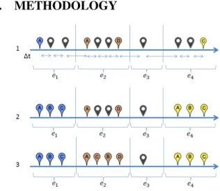
Figure 1: Examples of extrapolation (2) and interpolation (3). We present an Event-based Semantic Interpolation (EBSI) ap-proach for estimating missing coordinates for images with absent geo information. At the first step the system separates a photo
col-lection on a set of event-related clusters (e1− e4) based on
tem-poral information (∆t) only. The detail description of the method for event-based clustering of media presented in [16]. The example is visualized in Figure 1, markers with letters indicate photos with GPS data, dark ones are photos without GPS data. Considering the position of the image in accordance to temporal boundaries there are two possible cases for assigning missing data points:
1. Extrapolation (Figure 1 (2)) is the task of extending a known
sequence of values Ae1or Ce4.
2. Interpolation (Figure 1 (3)) is the task of estimation of a un-known sequence of samples within two un-known data points
Ae2 and De2. The linear interpolation can be described by
the formula 1, where the interpolant y can be computed
be-tween two point (xa,ya) and (xb,yb) on a given x.
y = ya+ (yb− ya)
x − xa
xb− xa
(1)
In the case of extrapolation we extract from the first Ae1or last
Ce4 geotagged image within an event e1,e4 and assign it
coordi-nates to all images without GPS-stamp Be1, Ce1,Ae4,Be4towards
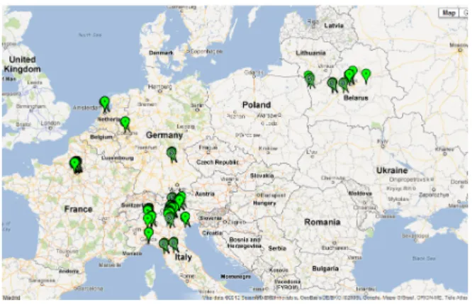
Figure 2: All locations of photos in the data-set automatically assigned by device and assign by EBSI ( slanted marker "S").
In case of interpolation we do the following steps. Knowing the
coordinates of two points where user made photos ( Ae2and De2)
during the event e2 EBSI quires on-line navigator in order to
un-derstand how user moves between those two points. The are three different variants of travel mode: walking, bicycling and driving. As soon as the travel mode is identified the system queries navi-gator again. This time it quires the coordinates of a point with the given coordinates of initial point, travel mode and temporal dis-tance to the next sample without coordinates. As the result the semantic analysis is done based on suggestions of travel routes
us-ing the Google Maps API4. If no route is provided, the locations
are linearly interpolated based on temporal distances. In case of
absence of geotagged samples within an event e3interpolation can
be done with help of samples from previous or next event (De2and
Ae4).
4.
EXPERIMENTAL SET-UP
In this section we describe the experimental setup for automatic geotagging of images with missing geographical coordinates. Firstly we will discuss the data set, followed by the experiment description and results.
4.1
Data Set
The data-set consists of 1615 images taken within a period of 1 year and 9,5 months. The data-set was produced unintentionally, meaning the owner was not aware that it would be used for this research. All images have time stamps and 901(55.79%) images have GPS stamps. The images have been captured in six countries and 32 cities and towns. The photos are taken by a Google Nexus
One5 smartphone with a 5MP resolution of 2592 × 1944, sRGB
IEC-61966-2 color profile and a fixed focal length of 4,31. For scientific purposes, the data-set is available on request.
The given data-set exemplifies a typical private photo collection. The ground-truth provided by the owner of the collection. The user reconstructed missing spatial information manually with the help
of Google Street View6. He reported at least 200 m accuracy of
placing for each sample. We compared his manual annotation with GPS coordinates automatically assigned to photos by the camera. The results can be seen on the Figure 3. The device is able to place
4https://developers.google.com/maps/documentation/geocoding/ 5 http://www.google.com/phone/detail/nexus-one 6 http://maps.google.com/help/maps/streetview/ 0 0.2 0.5 1 5 10 50 100 1000 0 10 20 30 40 50 60 70 80 90 100 Error in kilometers % o f p h o to s w it h GPS aq u ir e d au to m at ivca lly
Figure 3: Comparison of images with manual geoannotation and assigned by GPS-enabled device.
0.2 0.5 1 5 10 50 100 1000 0 10 20 30 40 50 60 70 80 90 100 Error in kilometers % o f p h o to s assi gn ed w ith G PS ESBI TBI LI
Figure 4: Comparison results for different approaches .
only 71% of images within 200 meters error. The results clearly indicate that GPS reception of the device is not always correct.
4.2
Experiments
For evaluation of our approach (EBSI) we propose to use linear interpolation (LI) as a baseline. We also tested temporal based interpolation (TBI) in order to estimate the influence of temporal information for interpolation process. For TBI we compute time distances between samples and on their basis perform interpola-tion. Achieved results presented on the Figure 4 and Table 1. It is worth to mention that EBSI was able to assign geographical coordi-nates only for 35.5% from the total number of images with missing geo information. This clearly indicates that vast majority of event-related clusters does not even contain a single sample with geo in-formation. For such a case TBI can be used or the user should be involved. TBI and EBSI shows the similar accuracy till 1 km preci-sion and both significantly outperform LI. However from the next threshold EBSI performance increases noticeably. This leap in per-formance allows to the system automatically place on the global map more than 83% of test images within the 5km error (Figure 2).
Error in km 0.2 0.5 1 5 10 50 100 1000 >1000
EBSI % of images 39.28 47.22 60.71 83.73 86.11 92.46 92.46 100 100
TBI % of images 37.70 48.02 61.11 66.27 67.86 74.60 74.60 100 100
LI % of images 26.19 32.14 38.49 50.79 53.97 64.29 69.05 84.52 100
Table 1: Experimental results for Event-Based Semantic Interpolation (EBSI), Time-Based Interpolation (TBI) and Linear Interpola-tion (LI)
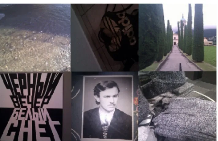
Figure 5: Most accurately interpolated images. EBSI works best if official roads are nearby, since the possible way of trav-eling is estimated online.
4.3
Conclusion
In this paper we introduce the novel method for automatic geo-tagging based on the context of personal media collection. Event-based interpolation of images with missing geographical informa-tion demonstrates promising results. The approach unveil the sig-nificant role of events which they play in reconstruction of missing geo-spatial information. The experiments show that we are able to assign geographical coordinates for 83% of images within an error of 5 km. This is done without looking at the content of the image. In some photos (Figure 5) content information does not provide any cues to distinguish the location where it was captured.
The approach does not require any kind of prior training. How-ever the accuracy of the proposed method highly depends on the number of images with assigned GPS coordinates within the col-lection. We believe that the combination of contextual, visual and textual information can significantly increase the robustness of the automatic geotagging.
5.
REFERENCES
[1] Javier Paniagua, Ivan Tankoyeu, Julian Stöttinger, Fausto Giunchiglia Media Indexing by Personal Events. ACM International Conference on Multimedia Retrieval (ICMR), 2012.
[2] Adam Rae, Vannesa Murdock, Pavel Serdyukov and Pascal Kelm. Working Notes for the Placing Task at MediaEval 2011. Working Notes Proceedings of the MediaEval 2011 Workshop (MediaEval), 2011.
[3] Maarten Clements, Pavel Serdyukov, Arjen P. de Vries, Marcel J. T. Reinders Personalised Travel Recommendation based on Location Co-occurrence. IEEE TRANSACTIONS ON KNOWLEDGE AND DATA ENGINEERING (IEEE), 2011.
[4] James Hays, Alexei A. Efros. IM2GPS: estimating
geographic information from a single image. Proceedings of
the IEEE Conf. on Computer Vision and Pattern Recognition (CVPR), 2008.
[5] Wei Zhang, Jana Kosecka. Image Based Localization in Urban Environments. Proceedings of the Third International Symposium on 3D Data Processing, Visualization, and Transmission. 3DPVT, 2006.
[6] Aude Oliva , Antonio Torralba. Modeling the Shape of the Scene: A Holistic Representation of the Spatial Envelope. International Journal of Computer Vision 3DPVT, 2006. [7] Laura Walker Renninger, Jitendra Malikb. When is scene
identification just texture recognition? Vision Research
Volume 44, Issue 19,, 2004.
[8] Cathal Hoare, Humphrey Sorensen. On Automatically Geotagging Archived Images. Libraries in the Digital Age
Proceedings LIDA, 2012.
[9] Pavel Serdyukov, Vanessa Murdock and Roelof van Zwol. Placing flickr photos on a map. In Proceedings of the 32nd international ACM SIGIR conference on Research and
development in information retrieval SIGIR ’09, 2009.
[10] Olivier Van Laere, Steven Schockaert and Bart Dhoedt Finding locations of flickr resources using language models and similarity search. In Proceedings of the 1st ACM International Conference on Multimedia Retrieval ICMR
’11, 2011.
[11] Martha Larson, Mohammad Soleymani, Pavel Serdyukov, Stevan Rudinac, Christian Wartena, Vanessa Murdock, Gerald Friedland, Roeland Ordelman and Gareth J. F. Jones Automatic tagging and geotagging in video collections and communities. In Proceedings of the 1st ACM International
Conference on Multimedia Retrieval ICMR ’11, 2011.
[12] David J. Crandall, Lars Backstrom, Daniel Huttenlocher and Jon Kleinberg. Mapping the World’s Photos. In Proceedings of the 18th international conference on World wide web
WWW’09, 2009.
[13] Dhiraj Joshi, Andrew Gallagher, Jie Yu and Jiebo Luo Inferring photographic location using geotagged web images. MULTIMEDIA TOOLS AND APPLICATIONS,
Volume 56, Number 1 , 2012.
[14] Pascal Kelm, Sebastian Schmiedeke and Thomas Sikora. A hierarchical, multi-modal approach for placing videos on the map using millions of Flickr photographs. In Proceedings of the 2011 ACM workshop on Social and behavioural
networked media access. SBNMA’11, 2011.
[15] Pierre Andrews, Jaiver Paniagua and Fausto Giunchiglia. Clues of Personal Events in Online Photo Sharing.
Detection, Representation, and Exploitation of Events in the
Semantic Web DeRiVE’11, 2011.
[16] Ivan Tankoyeu, Javier Paniagua, Julian Stöttinger, Fausto Giunchiglia. Event detection and scene attraction by very simple contextual cues. Proceedings of the 2011 joint ACM workshop on Modeling and representing events (J-MRE’11), 2011.