Borj Barajneh: reinterpretation of
a Palestine refugee camp in Beirut
Morphology, internal dynamics and articulations to its immediate environment
Elisabeth Habib 764887
Supervisor: Massimo Bricocoli
POLITECNICO DI MILANO
FACULTY OF ARCHITECTURE AND SOCIETY
Master of Science in Urban Planning and Policy Design
Borj Barajneh: Reinterpretation of a Palestine Refugee Camp in Beirut
Morphology, Internal Dynamics and Articulations to its Immediate Environment
Thesis supervisor:
Massimo Bricocoli
Candidate:
Elisabeth Habib 764887
Pity the nation that is full of beliefs and empty of religion.
Pity the nation that wears a cloth it does not weave, eats a bread it does not harvest, and drinks a wine that flows not from its own wine-press.
Pity the nation that despises a passion in its dream, yet submits in its awakening.
Pity the nation that raises not its voice save when it walks in a funeral, boasts not except among its ruins, and will rebel not to save when its neck is laid between the sword and the block.
Pity the nation whose statesman is a fox, whose philosopher is a juggler, and whose art is the art of patching and mimicking.
Pity the nation that welcomes its new ruler with trumpeting, and farewells him with hootings, only to welcome another with trumpeting again.
Pity the nation whose sages are dumb with years and whose strong men are yet in the cradle.
Pity the nation divided into fragments, each fragment deeming itself a nation.
―Gebran Khalil Gebran. The
Garden of the Prophet. (London, 1934)
ACKNOWLEDGMENTS
Since there are many people who helped, guided, and encouraged me along this way, first, I want to thank my dissertation supervisor, Massimo Bricocoli, who triggered my interest in the subject of this dissertation while I was attending his course on Urban Ethnography. He offered me his valuable contribution, guidance and patience throughout this research. I also want to express my gratitude to Ibrahim Eid without whom my visit to Borj Barajneh wouldn’t have been possible.
I am also grateful to Politecnico di Milano M.Sc. 2012 students who were helping and supporting each other continuously during these two challenging academic years. I particularly appreciate the great friendship of Pierre Karaa, Yara Haddad, Jihène Derouiche, Juliana Gómez Aristizábal, Hanane Joukhadar, Irene Karagavur, Juana Marcella Leal, Yening Liu, Marie-lyne Samaha, and Gennaro Carusone who put up with me and helped me throughout the writing of this dissertation.
Finally and most importantly, I offer my sincere thanks and love to my parents Nadim and Elvira, and my brother Alexandre, to whom this dissertation is dedicated, and who are key persons behind my academic success. Since my childhood, they believed in my intellectual capabilities and I hope that I will never disappoint them.
Borj Barajneh: Reinterpretation of a Palestine
Refugee Camp in Beirut
Morphology, Internal Dynamics, and
Articulations to its Immediate Environment
by
Elisabeth Habib
Submitted to the Faculty of Architecture and Society on
December 21, 2012 in partial fulfillment of the requirements for the degree of Master of Science in Urban Planning and Policy Design
ABSTRACT
This dissertation analyzes the creation and evolution of one of Lebanon’s twelve Palestine refugee camps, Borj Barajneh, located in the southern suburbs of Beirut, from the 1948 Arab-Israeli War, through to the end of the 1975-1990 Civil War and to present days. This study seeks to understand to which extent Borj Barajneh is part of the city today. With this aim in view, this study presents a comprehensive analysis of the spatial practices and policies that have shaped and still affect the morphology and internal dynamics of the camp and its articulations with its immediate environment.
Firstly, this dissertation focuses on three main issues resulting from my analysis of several official reports, articles, conferences, the literature on the subject, a field trip to Borj Barajneh and interviews I conducted with the camp dwellers: (1) the lack of planning tools in Lebanon and the random
urbanization in the suburbs of Beirut; (2) the location of Borj Barajneh in a stigmatized and marginalized suburb of Beirut, and (3) the non-interventionist strategy adopted by the Lebanese state towards the Palestinian issue and the planning of the refugee camps.
Secondly, having set the legal, spatial, social, economic, religious, and politic framework in which Borj Barajneh is implemented, this dissertation presents four main findings. First, the space of the camp represents a strong symbol of the refugees’ Palestinian identities in the host countries. Second, the space of the camp constitutes a physical representation of the legal restrictions imposed on the Palestinians. Third, as a refuge, the camp redefines its role on a local scale. Finally, as a humanitarian space, the camp creates ties with its surroundings.
Finally, this dissertation shows that despite the spatial and legal practices used by the Lebanese authorities to weaken and isolate the Palestine refugees, they however manage, through their own socio-spatial practices, to render Borj Barajneh’s borders porous, to open up the space of the camp, and to call for a reinterpretation of the role of the camp on a local scale.
Keywords: Lebanon, Palestine refugee camps, spatial practices, policies, Borj
Borj Barajneh: Reinterpretazione di un Campo
Profughi Palestinese a Beirut
Morfologia, Dinamiche Interne, e
Articolazioni con l’Ambiente Circostante
da
Elisabeth Habib
Presentato alla Facoltà di Architettura e Società il
21 Dicembre 2012 in adempimento parziale dei requisti per il grado di Laurea Magistrale in Pianificazione Urbana e Politiche Territoriali
RIASSUNTO
Questa tesi analizza la creazione e l’evoluzione di uno di dodici campi per rifugiati palestinesi presenti in Libano, Borj Barajneh, situato nella periferia sud di Beirut, dal suo insediamento a seguito del conflitto arabo-israeliana del 1948, fino alla fine della guerra civile del 1975-1990 e ai giorni nostri. L’obiettivo del lavoro è capire fino a che punto il campo Borj Barajneh sia effettivamente integrato nell’ attuale tessuto sociale/urbanistico di Beirut. La tesi presenta un’analisi completa degli strumenti urbanistici e regolamenti di governo del territorio che hanno dato forma e ancora influenzano la morfologia e le dinamiche spaziali interne del campo e le sue articolazioni con l’ambiente circostante.
In primo luogo, questa tesi si incentra sulle tre principali problematiche riscontrate dall’analisi di diversi rapporti ufficiali governativi, articoli, atti di conferenze, dalla letteratura, nonché una visita a Borj Barajneh e le interviste
agli abitanti del campo: (1) la mancanza di strumenti di pianificazione in Libano e l’urbanizzazione casuale della periferia di Beirut, (2) la posizione di Borj Barajneh in una periferia di Beirut stigmatizzata ed emarginata, e (3) la strategia non-interventista adottata dallo Stato libanese verso la questione palestinese e la pianificazione dei campi profughi.
In secondo luogo, dopo aver chiarito il quadro giuridico, spaziale, sociale, economico, religioso e politico in cui si è sviluppato il campo Borj Barajneh, sono presentati i quattro principali risultati conseguiti dall’analisi: lo spazio del campo rappresenta un simbolo forte d’identità dei profughi palestinesi nei paesi ospitanti, costituisce una rappresentazione fisica delle restrizioni legali imposte ai palestinesi, come rifugio, ridefinisce il suo ruolo sulla scala locale, ed infine, nella sua funzione di uno spazio umanitario, il campo crea legami con tutto l’ambiente circostante.
In conclusione, questo lavoro di tesi dimostra che, nonostante le politiche di governo del territorio imposte dalle autorità libanesi per indebolire e isolare i profughi palestinesi, questi siano riusciti, attraverso le proprie consuetudini socio-spaziali, a rendere porosi i confini di Borj Barajneh, ad aprire lo spazio del campo, e ad invitare ad una reinterpretazione del ruolo del campo sulla scala locale.
Parole chiavi : Libano, campi profughi palestinesi, pratiche spaziali, politiche
TABLE OF CONTENTS
List of Figures, Graphs, Maps, Photos, Tables vii
List of Acronyms and Abbreviations ix
Chapter 1: Introduction 1
1.1 Research content 1
1.2 Aims and objectives 2
1.3 Methodology 2
Chapter 2: Palestine refugee camps in Lebanon 5 2.1 Demography of the refugee camps in Lebanon 5 2.2 Planning and development framework in Lebanon 7 2.2.1 Public stakeholders and the National Physical Master Plan of
the Lebanese Territory 7
2.2.2 The refugee camps in Beirut: camps on the edge of the city 9 2.2.3 The Palestine refugees in the National Physical Master Plan of the Lebanese Territory and the Lebanese Law 13 2.3 Main actor in the management of the camps: the role of United
Na-tions Relief and Works Agency 17
Chapter 3: 1948-1990: from Palestine to Lebanon: Creation and Evolution of
Borj Barajneh 21
3.1 1948-1952: exile and the years of adaptation 21 3.1.1 1948 Arab-Israeli War and creation of the State of Israel 21 3.1.2 The first years of exile and the creation of Borj Barajneh 22
3.2 1952-1969: evolution of the housing in Borj Barajneh 25 3.3 1969–1990: Borj Barajneh in time of war 27 3.3.1 1969–1982: Borj Barajneh under the control of the Palestine
Liberation Organization 27
3.3.2 1982–1990: War of the Camps and end of the civil war 28 3.3.3 Consequences of the civil war on the marginalization of the
refugees 29
Chapter 4: Borj Barajneh Today: Reinterpretation in a Local Context 31 4.1 The refugee camps as laboratories 31 4.1.1 The refugee camps as spaces of exception 31 4.1.2 The refugee camps, open or closed spaces? 34 4.1.3 The refugee camps, porous or impermeable spaces? 35 4.2 Borj Barajneh: morphology and internal dynamics 35 4.3 Borj Barajneh: articulations to its environment 45
Chapter 5: Final Remarks 48
5.1 Main findings 48
5.2 Some orientations and recommendations 50
Endnotes 51
Appendixes 55
A. Chronology of Events 55
B. Main Palestinian Political Factions in Lebanon 56
D. Taif Agreement 58
E. The Hezbollah and the Amal Movement 63
List of Figures, Graphs, Maps, Photos, Tables
Figures
Map 2-1: Demography of the Palestine refugee camps in Lebanon 6 Map 2-2: Three different views to better understand the territory 6
Map 2-3: The 1996 Elyssar Project 13
Map 2-4: UNRWA’s fields of operation, recognized camps and population by field in 2012 18
Map 3-1: Palestine 1947 UN Partition Plan 22
Map 3-2: Armistice demarcation lines of 1949 22
Map 3-3: Flows of Palestine refugees in 1949 23
Map 3-4: Palestine refugees displaced from urban and rural areas in 1949 23 Map 4-1: Distribution of the six main religious groups in Lebanon and Beirut 33 Map 4-2: On the left: pre-1948 Palestinian villages in present-day Israel; on the right:
Borj Barajneh’s five neighborhoods 36
Map 4-3: The surface of Borj Barajneh in comparison with the Piazza del Duomo area
in Milan 36
Map 4-4: Map of Borj Barajneh representing housing, services facilities, and economic
activities 43
Map 4-5: Borj Barajneh and its immediate environment, a patchwork of four different
patterns 45
Map 4-6: Borj Barajneh and its articulations to its immediate environment 47 Figure 2-1: Evolution of the urban sprawl of Beirut from 1922 to 2000 10
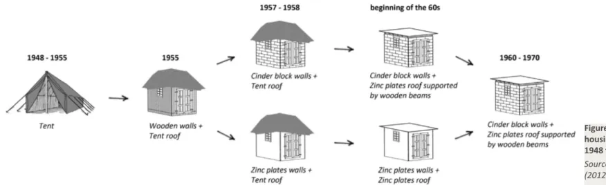
Figure 3-1: Evolution of housing in Borj Barajneh from 1948 to 1970 26
Figure 3-2: Emblem of the PLO 27
Figure 3-3: From displacement to confinement and densification, 42 years of
urban processes 29
Figure 4-1: Diagrams City as a Tree and Open City 32
Photo 2-1: Signs, objects, and images marking the territorial space of the dahiye 12 Photo 2-2: UNRWA’s omnipresence in Borj Barajneh camp 19 Photo 3-1: Palestinians fleeing from the newly established State of Israel in 1948 22 Photo 3-2: Graffiti painting in Rafah refugee camp, southern Gaza Strip “We will
return” 23
Photo 3-3: Refugee camp in northern Lebanon, early 1950s - the temporality of the
Graphs
Maps
Photos
Graph 2-1: Number of buildings constructed in Beirut and its suburbs from
1950 to 1995 10
Graph 2-2: Palestinian workers by sector of employment 15 Graph 2-3: Palestinian workforce distribution 15 Graph 2-4: School enrolment distribution among Palestinians aged between 7
and 18 15
Graph 2-5: Educational level in relation to employment among Palestine
refugees in Lebanon 15
Graph 2-6: Highest completed education among Palestinians 15 Graph 2-7: Infrastructure problems faced by Palestine refugee households in
Lebanese camps 16
Graph 2-8: Distribution of refugees by registration status and geographical area 18 Graph 3-1: Evolution of the population in Borj Barajneh between 1952 and
Tables
Table 2-1: Lebanon at a glance 5
Table 2-2: Public key players in urban planning in Lebanon 7 Table 2-3: The Palestine refugees in the framework of the NPMPLT 14 Table 2-4: The sectarian composition of Lebanon and the naturalization of Palestinians 16 Table 2-5: Three different categories of Palestine refugees in Lebanon 17 Table 2-6: Distribution of the registered Palestine refugees in between camp and
urban dwellers in 2012 19
Table 2-7: Camp governance actors in Lebanon through the years 19 Table 4-1: Borj Barajneh ‘s major problems and main available services 42 refugee condition was expressed through the tents, provisional and weak
shelters 25
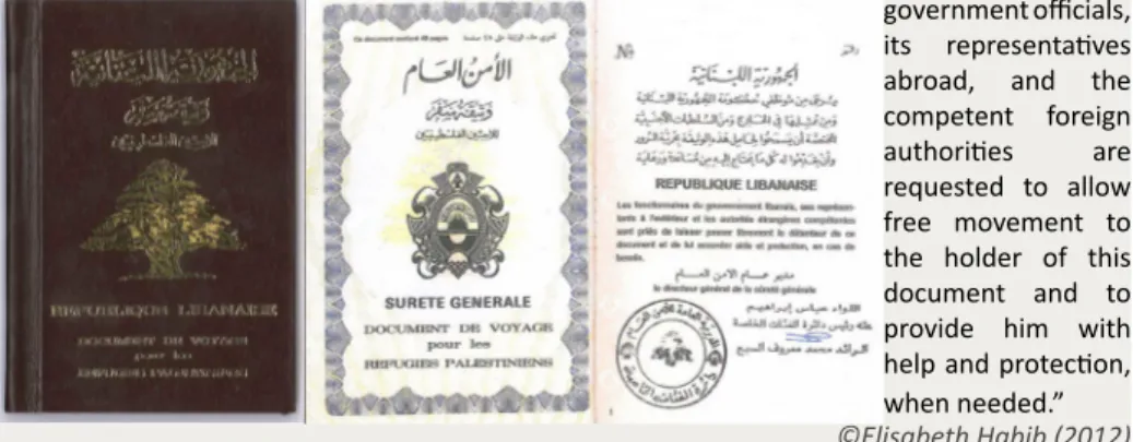
Photo 4-1: Republic of Lebanon Travel document for Palestine refugees 32 Photo 4-2: First and second generation gathered in one of the few squares of
the camp 36
Photo 4-3: Two additional floors are visible on the building in the bottom left
corner 37
Photo 4-4: In this commercial alley completed bathed in darkness the way is
visible thanks to the shops’ lighting 37
Photo 4-5: The difference in altitude strongly shapes the habitat and the road
network 37
Photo 4-6: Some alleys are too narrow to allow two persons to walk side by
side 38
Photo 4-7: Motorcycles and bicycles are the predominant means of transport 38 Photo 4-8: Rusted electric board located in open air and dangerously suspended electric cables. The proximity of the Mediterranean Sea accelerates rust and
corrosion in the camp. 39
Photo 4-9: A tower tank of 250 m3 providing the refugees with salty water used
for cleaning and showering 39
Photo 4-10: The EU funded project (on the right) replaced the old rusted water supply system (on the left) and elevated it in order to increase the pressure of the water and to ensure the efficiency of the whole network 40 Photo 4-11: An example of an EU funded program on camp infrastructure improvements 40 Photo 4-12: “Palestine, the 194th state recognized by the UN” a banner in Borj Barajneh asking for the UN recognition of the Palestinian National Authority as
a fully sovereign state 40
Photo 4-13: There are only two medical centers within the camp: Haifa Hospital
(left) and UNRWA clinic (right) 41
Photo 4-14: Even with diplomas issued by Lebanese universities, Palestinians are not allowed to practice medicine in Lebanon like this gynecologist, this dental surgeon and this general surgeon who opened their clinics within Borj Barajneh camp limits. 41 Photo 4-15: A teaching center for technical education provides trainings in languages,
computers, accouting, and private lessons 41
Photo 4-16: Considerably restricted in their employment opportunites in Lebanon, numerous Palestinians open their businesses inside the camps like here in Borj
Barajneh 42
Photo 4-17: Al-Amliyah entrance viewed from Al-Imam El Khomayni Road 46 Photo 4-18: The high middle class neighborhood of Raml Al Aali in the background, on
the other side of Al-Imam El Khomayni Road 46
Photo 4-19: Lebanese soldiers and policemen, although scattered on a daily basis throughout the entire territory of the dahiye like shown in the pictures below, are
List of Acronyms and Abbreviations
ANERA American Near East Refugee Aid
AUB American University of Beirut
CAS Central Administration of Statistics
CDR Council for Development and Reconstruction
CEP Committee for the Employment of Palestine refugees in Lebanon
CIA Central Intelligence Agency
CoM Council of Ministers
DGUP Directorate General for Urban Planning
DPRA Directorate General for Political and Refugee Affairs in Lebanon
Elyssar Public Agency for the Planning and Development of Beirut South-Western Suburbs
EU European Union
Fafo Norwegian Institute for Applied International Studies
HCUP Higher Council for Urban Planning
IAURIF Institut d’Aménagement et d’Urbanisme de la Région Île-de-France
ICRC International Committee of the Red Cross
IFPO Institut français du Proche Orient
ILO International Labor Office
LRCS League of the Red Cross Societies
MoE Ministry of Environment
MoFA Ministry of Foreign Affairs
PFLP-GC Popular Front for the Liberation of Palestine – General Command
PLO Palestine Liberation Organization
PRCS Palestinian Red Crescent Society
SDC Swiss Agency for Development and Cooperation
Solidere Société Libanaise pour le Développement et la Reconstruction de Beyrouth
UN United Nations
UNDP United Nations Development Program
UNHCR United Nations Higher Commissioner for Refugees
UNRWA United Nations Relief and Works Agency for Palestine refugees in the near east
CHAPTER 1: INTRODUCTION
“We wanted to change the world but the world changed us.”
―Ettore Scola. C’eravamo tanto amati. (1974)
1.1 Research content
From October 2010 to February 2011, I attended a course on Urban Ethnography within the framework of my curriculum at Politecnico di Milano. During this course, I was introduced to the works of Eyal Weizman, an Israeli architect Professor of Spatial and Visual Cultures at the University of London. This is how I came to read his 2007 book Hollow Land: Israel’s Architecture of Occupation. Being Lebanese, and due to the presence of Palestine refugees in Lebanon, I have been introduced very soon to the notions of ‘refugees’ and ‘occupied territories’. However, my knowledge was rather broad and was limited to the fact that Lebanon hosted Palestine refugees because the conflict that has been going between Israel and the Palestinians since 1948 has not yet come to an end. I was not aware of the real dynamics of this conflict and its repercussions on the neighboring countries. Eyal Weizman book is written in the form of a story much more than in the form of an academic essay. A sinister story. With the clarity of vision of an artist, Weizman depicts Israel’s mechanisms of control
and occupation of the Occupied Territories. By transforming the landscape and the built environment into tools of domination and control, Israel introduces a three-dimensional (in the air, on the ground, and underground) urban warfare and lays down the role of spatial practices in the politicization of space. When I finished reading Eyal Weizman’s book, my first reaction was that I wanted to base my dissertation on the topics it tackles: how are surfaces and regulations used to control entire populations and contain them on a specific territory? How does this politicization of the space reflect on the territory? What kind of scissions/ties does this politicization of the space create with the surroundings of the territory? After a discussion with Professor Massimo Bricocoli, we came to the conclusion that it would be interesting to study this question in the framework of the Palestine refugee camps in Lebanon rather than the Occupied Territories as I first intended to do. This suggestion was also justified by the fact that, by basing my study in Lebanon, I could conduct field trips and study the territory in which the camp is implemented. I could also interview the refugees and draw a map of their daily movements, thus understanding the camp’s dynamics and its articulations to its immediate environment.
The choice of one specific camp, Borj Barajneh, was not random. Before starting to work on this dissertation, I perceived the Palestine refugee camps as dangerous spaces where I was forbidden to go. Other than perceiving the refugees as undesirable outlaws, I didn’t knew much about them nor the spaces which they inhabited. I remember family trips to my father’s village in south Lebanon where we had to pass nearby the camps; my mother used to be anxious for a few minutes and wouldn’t stop asking why we really had to go through these ‘zones’. Moreover, throughout history, the camps have proven to be spaces of violence, out of the reach of the Lebanese authorities.
The last clash to date is the conflict of 2007 between the Lebanese Army and Fatah al-Islam, an Islamist militant organization. Of course, the news only relate the violence in the camps, to feed the Lebanese resentment against the Palestinians, and it is difficult for anyone who hasn’t visited a camp to imagine that people are living there, accomplishing everyday chores, working and studying, making friends, marrying and starting a family. Definitely, it is not only outlaws using the camp as a refuge from the authorities. But still, the choice of the camp was not easy or random. When embarking on a trip to a new place, we buy touristic guides, we ask our friends that have been there for tips, things to do and things to avoid. Somehow, approaching the idea of visiting a camp, this was an experience I had to go through, not having any previous reference or clear image. Even implemented in my country and inhabited by people speaking the same language as I do, the camps represent unknown closed off spaces, no-go areas. When passing by the camps by car, one cannot see what is happening inside the camp and its external morphology is similar to that of the poorest Lebanese neighborhoods. Hence, I had to enter in contact with a Palestine refugee willing to help me on my ‘research’. I met Ibrahim Eid, a surveyor working within the international multidisciplinary consultancy firm Dar al-Handasah (Shair and Partners) in Arbil (Iraq), through my father who works in that same firm. I used the term ‘research’ and not ‘dissertation’ or ‘academic project’ because I felt, when I first talked to mister Eid, that he, and the other refugees in general, was more willing to help me if the work I was doing led to a concrete project of rehabilitation within the camps. Mister Eid lives in Borj Barajneh, and this is how I ended up studying the case of the refugee camp of Borj Barajneh. Later in my research work, Borj Barajneh proved to be itself an extraordinary and interesting example of reinvention in which the space of the camp develops into a multicultural environment.
1.2 Aims and objectives
The subject of this dissertation tackles issues of war-displacement, political and sectarian affiliation, ethnic marginalization, and intra-religious conflicts. These are extremely sensitive issues in Lebanon and especially among the leading classes. Politicians avoid dealing with the Palestinian issue in Lebanon, many are afraid to revive a war whose scars are still visible, twenty-two years later, throughout the Lebanese cities and territory.
In this dissertation, my aim will be to establish how the Lebanese government but also local and “phantom” (this term, explained later in paragraph 2.3, refers to UNRWA’s perceived role and its actual function) actors have used spatial practices and policies to control and contain the Palestinians. My ultimate objective will be that of determining the internal dynamics of Borj Barajneh and its articulations to its immediate environment.
1.3 Methodology
Throughout the writing of this dissertation, it was very difficult to collect data. First of all, the last official census dates back to 1932 that is 80 years ago. Since then, Lebanon has experienced independence, a fifteen-year civil war, and several short-term conflicts, all of which deeply influenced the demographics of the country through emigration, internal and foreign immigrations, but also many deaths. Therefore, current available information about population, income, and education is only based on estimations. Moreover, although the Central Administration of Statistics has achieved considerable progress in gathering data, information about many services and living conditions are either incomplete or rarely updated. This concerns the following categories: water networks and resources, wastewater networks, electricity, profile of
land owners, detailed land use maps, soil type, as well as other data categories related to anthropology and sociology. In addition, almost 50% percent of the country has not been surveyed yet and it was impossible for me to collect maps of Borj Barajneh and the surrounding neighborhoods. It is only thanks to mister Eid and his work with the United Nations Relief and Works Agency for Palestine refugees in the near east (UNRWA), during which his task was to survey the camp, that I was able to obtain a map of the camp with the various services and shops within it. I adapted and integrated this map, an AutoCAD file, using the findings of my field work.
This study is based on annual reports of the UNRWA and other sources on the Palestinian refugees in Lebanon: articles I retrieved from websites such as SAGE.com and Academia.edu and researches I found at the Institute for Palestine Studies in Beirut or at the Institut français du Proche Orient located in the French Embassy of Beirut. Laws and regulations were retrieved from the National Physical Master Plan of the Lebanese Territory report, kindly given by Dar al-Handasah (Shair and Partners) when I was doing my internship there, but also from reports I retrieved from the Ministry of Environment and Council for Development and Reconstruction (CDR) websites. Theoretical concepts of my dissertation are based on literature from the libraries of the Politecnico di Milano and the Université Saint-Joseph (Beirut). Finally, and even though I couldn’t meet him, I watched various videos of conferences given/moderated by French-Palestinian Professor of Sociology at the American University of Beirut, Sari Hanafi. These videos gave me a thorough understanding of the role of the Lebanese state, the local actors, and the UNRWA in the governance of the Palestinian refugee camps.
In the course of this research, I conducted two field trips. Even though I live very close to the camp (six kilometers by car), I wasn’t able to visit the camp
more than one time. The visit to the refugee camp of Borj Barajneh, on August 23, 2012 was made possible thanks to the help of mister Eid, my guide during this visit, who welcomed me in his house and without whom it would have been impossible to find my way in the intricate alleys of the camp. Also, as mister Eid is a respected member of the Palestinian population within Borj Barajneh, he considerably eased my interviews and directly introduced me to refugees who could answer the many questions I had but also tell me about their daily lives within the camp. I also had the chance to meet Abu Muhamad, a refugee now living in Denmark who happened to be on holidays in Lebanon at the time of my visit. On several occasions, especially near the offices of political parties, I was asked not to take pictures. Sometimes also, mister Eid would point at a certain group of Palestinian men and ask me not to talk with them, without further explanations. I supposed it was because of a disagreement over politics. Overall, despite feeling ill at ease, the visit went smoothly and I was able to gather a lot of information.
A few days after my visit, I was having dinner with some acquaintances and, while telling them about my visit, their first reactions were:
-“Why would you go to a Palestinian camp?” -“How did you do it?”
-“Was it safe?”
-“Did something bad happen to you while you were there?”
We usually hear stories of violence happening in the camps of northern and southern Lebanon, but rarely in the camps of Beirut’s suburbs. As I was expressing this thought, one of the persons present at this dinner recalled:
-“A few years ago, while I was doing an academic research, I wanted to visit Borj Barajneh and, for me, it ended up being a bad experience. I entered alone, with no guide or acquaintance from the camp, and, quickly, I was harassed by Palestinian men who wanted to know why I
was there, why I was taking pictures and trying to talk to people. Feeling unwanted and unsafe, I just left. I came back only a few days later, this time accompanied by a Lebanese social worker who used to visit the camp on a regular basis and to whom the refugees were accustomed.”
Knowing that a disagreeable experience happened to one of my acquaintances in this very camp, I felt even less comfortable to visit Borj Barajneh a second time. Later in this dissertation, I will explain how my field visit brought me to conclude that, through their socio-spatial practices, the Palestine refugees manage to open up the space of the camp and to render its borders porous. Despite this conclusion, and as I will also explain later, the Palestine refugee camps are still out of reach of the Lebanese authorities. Soldiers of the Lebanese Army are scattered throughout the dahiye but also throughout the entirety of the Lebanese territory, to a point that soldiers and tanks have became part of our daily urban landscape. However, I didn’t see a single Lebanese soldier/ policeman inside the camp. Added to the testimony mentioned before but also to my original apprehension of visiting a Palestinian camp, something inherent to the Lebanese people, this reinforced my feeling of insecurity and I did not reiterate my visit to the camp. The second field trip, on October 8, 2012, consisted in visiting the surroundings of the camp, by car, in order to understand the differences/resemblances in morphology between the camp and its surroundings. Even outside the camp, on ‘Lebanese territory’, taking pictures was not something easy. Soldiers are scattered all over the dahiye, this suburb of Beirut in which Borj Barajneh is located, stronghold of the Hezbollah, and one is always concerned not to catch the attention of a militant by taking pictures. Some pictures were usable and others were blurry, my mother driving too fast, afraid to catch the attention of a suspicious eye.
CHAPTER 2: PALESTINE REFUGEE CAMPS IN LEBANON
“Spaces of transit and waiting, [the camps] are organized like ‘cities’ yet without strategic planning as everything is designed not to last. They stabilize and last.”
―Michel Agier. Le son de la guerre. (2005)
2.1 Demography of the refugee camps in Lebanon
Lebanon (see Table 2-1 for general information about the country) counts twelve refugee camps which are mostly implemented around the four biggest cities of the country – Tripoli, Beirut, Saida, and Tyre – and have gradually become part of them. As shown in Map 2-1, the demographic situations are very different among the camps. We can distinguish three categories of camps: those of more than 25,000 registered1 inhabitants, Ein el Hilweh, Nahr
el-Bared, and Rashidieh; those who accommodate between 10,000 and 25,000 registered refugees, Borj Barajneh, El Buss, and Borj Shemali; and finally the remaining six whose population doesn’t exceed 10,000 registered inhabitants, Wavel, Dbayeh, Mar Elias, Shatila, Mieh Mieh, and Beddawi. Though the size and the number of inhabitants may vary from camp to camp, the refugee camps are mostly characterized by a high population density. Within the
framework of this dissertation, I will focus on the area known as the southern suburbs of Beirut (al-dahiye al janubiya - ةيبونلجا ةيحاضلا in Arabic) which with an area of 16 square kilometers for 400,000 to 500,000 inhabitants is almost as big and inhabited as Beirut. At the core of this area, the refugee camp of Borj Barajneh with its 16,888 inhabitants gathered on 0.2 square kilometers – which represents a density of 84,440 in/km2 – will be my area of study (see Map 2-2).
Capital (and largest city) Beirut
Spoken languages Arabic, French, English, and Armenian
Government Democratic Parliamentary Republic
Independence 22 November 1943 from French Mandate
Area Lebanon 10,452 km2 - about half the size of the
Lombardy Region
Beirut 20 km2 Urban area of Beirut 100 km2
Population Lebanon 4,140,289 (CIA World factbook July 2012 estimations) about half the population of the Lombardy region
Beirut 361,366 (UNdata 2008)
Urban area of Beirut 1,909,000 (CIA World factbook 2009)
Density 404 in/km2 (28th, including Palestine refugees) Urban population 87% of total population (CIA World factbook
2010)
Urban population growth rate 2.2% (MoE/UNDP/ECODIT, 2011)
Map 2-2: Three different views to better understand the territory Map 2-1: Demography of the Palestine refugee camps in Lebanon
Source: adapted from UNRWA (2012)
Role and Responsibilities Key Player
The CDR is a public institution created as a replacement for the Ministry of Planning on January 31, 1997 by the Decree-Law 5. It is responsible for the planning and programming of reconstruction and rehabilitation projects in all sectors and across Lebanon4. It is also mandated to develop the National Physical Master Plan. Almost
85% of all funds allocated for reconstruction transit through the CDR. Although directly linked to the CoM, it can bypass ministries to accelerate projects when needed. Council for
Development and Reconstruction (CDR)
The DGUP falls under the authority of the Ministry of Public Works and Transport. Its mandate is to develop regulations and orchestrate urban planning. It defines urban master plans and issues building permits for municipalities that do not have a municipal council or an engineering department (this includes most of the municipalities in Lebanon except Beirut, Tripoli, Federation of Municipalities of Jbail, Kesrouan, and Matn). Master plans need to be approved by the DGUP and decreed by the CoM within a maximum period of three years. If the approved master plan is not decreed by the CoM within three years, then the master plan is considered void and is replaced by the urban planning regulation in vigor before the master plan was approved by the DGUP. Directorate
General for Urban Planning (DGUP)
The HCUP was established on September 24, 1962 by the Decree-Law 69. It is presided by the DGUP and consists of the Director Generals of select ministries (Interior and Municipalities, Housing, Public Works and Transport, Justice, and Environment), representatives from several institutions (CDR), and urban planning specialists. It reviews and approves urban master plans as well as large-scale development projects; it drafts decrees related to the establishment of real estate companies, land expropriation, and land parceling; it reviews decisions related to licenses for construction and parceling; and finally it reviews proposed amendments to urban planning and construction legislation.
Higher Council for Urban Planning (HCUP)
Lebanon has 994 municipalities. Municipalities and municipal federations have many responsibilities (all that concern physical development in their territorial limits). They implement urban projects; follow up on cleanliness and public health issues, water works, public transport, and tax collection. They may also request from the DGUP the definition of urban master plans and could implement such plans with the DGUP’s accord, provided the municipalities have the necessary resources. Municipalities are also responsible for receiving applications for construction permits and issuing permits (although the construction permit needs the approval of the DGUP). Municipalities fall under the auspices of the Minister of Interior and Municipalities, which controls the Independent Municipal Fund (IMF). This control has generally been seen as limiting the maneuverability and actions of municipalities.
Local municipalities
Source: (MoE/UNDP/ECODIT, 2011)
Table 2-2: Public key players in urban planning in Lebanon
2.2 Planning and development framework in Lebanon
2.2.1 Public stakeholders and the National Physical Master Plan of
the Lebanese Territory
In Lebanon, land use and urban planning involve several public stakeholders: the Council for Development and Reconstruction (CDR), the Directorate General for Urban Planning (DGUP), the Higher Council for Urban Planning, local municipalities, and private land owners. Since 1999, the Ministry of Environment is often consulted by the DGUP to guide urban planning towards a “more holistic, integrated approach reconciling the imperatives of economic/ social development and the urgency of protecting the environment and sustaining natural resources” (European Commission, 2006, p.119).
These public stakeholders (see Table 2-2 for a summary of their role and key responsibilities) rarely carry out planning projects (such as public housing or urban renewal). In its 2006 report on Lebanon, the Institut d’Aménagement et d’Urbanisme de la Région Île-de-France2 (IAURIF)explains this as a result
of the characteristic Lebanese relief. In fact, Lebanon is a small country (ranks 167 among 249 countries3) predominantly mountainous (about 75% of its
territory) of approximately 4,140,289 inhabitants. According to the IAURIF studies, 65% of the population lives on 19% of the territory situated at an altitude below 400 meters (IAURIF, 2006); this represents a limited land area with a high population density. Not only determining the habitable areas, the relief also plays an important role in the isolation of regions and requires heavier investments in transportation infrastructures than plains. Hence, in a country such as Lebanon, it is not surprising that public planning is reduced very often to the design and construction of transportation infrastructures.
It is mainly the private sector that carries out the housing and reconstruction projects. In fact, the most relevant planning process that Lebanon has undergone in its history, the reconstruction of downtown Beirut, was carried out by the private joint-stock company Solidere5 (IAURIF, 2006). Moreover,
even though the State decrees planning regulations particularly permissive and with high building densities, the excesses are frequent (additional floors and densities) and illegalities are often regularized (IAURIF, 2006). Added to the random urbanization that Lebanon has been experiencing since the civil war, this has led to the deterioration of the quality of the urban environment. Moreover, at the administrative level, there are significant deficiencies in the data collection. In its 2011 report State and Trends of the Lebanese Environment (MoE/UNDP/ECODIT, 2011), the Ministry of Environment cites in particular:
- The last official census dates back to 1932 that is 80 years ago. Since then, Lebanon has experienced independence, a fifteen-year civil war, and several short-term conflicts, all of which deeply influenced the demographics of the country through emigration, internal and foreign immigrations, but also many deaths;
- Almost 50% of the country has not been surveyed yet;
- An estimated 84% of the country has no master plans yet. Unplanned areas are managed by regulations that rely on the lot coverage and floor-area ratio. For instance, in residential areas these coefficients are respectively 25% and 50%. In other terms, a landowner can construct on 25% of his parcel and build two floors to achieve the floor-area ratio of 50%;
- Although the Central Administration of Statistics has achieved considerable progress in gathering data, information about many services and living conditions are either incomplete or rarely updated. This concerns the following categories: water networks and resources, wastewater networks, electricity, profile of land owners, detailed land use maps, soil type, as well as other data categories related to anthropology and sociology;
- The majority of technical employees working at the DGUP are architects and civil engineers with little to no expertise in urban planning.
These various deficiencies, added to the almost non-existent public participation in the urban planning process, have frequently led to the lack, or the development and implementation of inadequate master plans.
In 2001 and in line with the principles of Agenda 216, the Council of Ministers
commissioned the CDR to prepare a National Physical Master Plan of the
Lebanese Territory in order to promote sustainable land management (MoE,
2012). The Physical Master Plan underlines a turning point in the action of the public administrations in Lebanon. It established, for the first time since the country’s independence, the basic principles of land use and of spatial organization. The Physical Master Plan was developed from March 2002 to May 2004, on behalf of the CDR, and in collaboration with the DGUP, by a consortium bringing together IAURIF and Dar al-Handasah (Shair and Partners)7, with assistance from local design and engineering offices
(CNBureau, Consulting & Research Institute, AAA, URBI, Ecodit) and the Remote Sensing Centre of the Lebanese Scientific Research Council (IAURIF, 2006). The Physical Master Plan identifies the physical features affecting land use, future challenges, various guidelines for land use and development, and proposes sector-specific implementation phases (transportation, tourism, industry, agriculture, education, environment, urban planning, etc.) (CDR, 2005). The final report of the Physical Master Plan was published in 2004 (in its first edition) but the Council of Ministers only ratified it in 2009 by effect of the Decree-Law 2366 (MoE, 2012). The Physical Master Plan is the latest report addressing land use and urban planning in Lebanon.
2.2.2 The refugee camps in Beirut: camps on the edge of the city
In order to study and understand the articulations of the refugee camps to their environments, it is first relevant to analyze these surroundings. As seen in Map 2-1, three refugee camps are located in the urban area of Beirut: Mar Elias, inside the boundaries of Beirut-city, and Shatila and Borj Barajneh, in the southern suburbs of Beirut. The southern suburbs originally developed around the capital and the agro-industrial flatlands of Hadath-Choueifat. The first urban planning projects regarding the development of the southern suburbs of Beirut date back to the period of the French mandate (1920-1943) and proposed the creation of a new town. For René Danger (1931-1932), the creation of a new town carried a spatial meaning where his master plan consisted in the creation of a garden city. In fact, the garden-city, a method of urban planning initiated in 1898 in the United Kingdom by Sir Ebenezer Howard, embodied a “hygienist ideology” (Mauriat, 1997) with a spatial order that contrasted with the disorder of the built-up areas of Beirut. Later, for the French urban planner Michel Ecochard (1941-1944), the creation of a new town carried in fact a social meaning where the southern suburbs were to be transformed into “dormitory suburbs” (Harb, 1996), a low density area mainly occupied by working-class housings. The links between urban planning and politics took several meanings depending on different times during the period that goes from the Independence to 1982. In the 1950s, and particularly during the tenure of President Camille Chamoun (1952-1958), planning was very much a tool aimed at and instrumental to an ideology promoting an independent and liberal country formed by a society of hierarchical classes (Verdeil, 2010). This is how, with the aim of creating “luxurious suburbs” (Harb, 2003), various large infrastructures either government-funded (the International Airport of Beirut, the Camille Chamoun City Stadium) either privately-funded (the Golf Club) were implemented in the southern suburbs. Master plans of
high-standing residential developments (some were actually implemented in the neighborhoods adjacent to the Airport road) were also designed by private large developers.
This ideology of an elitist society in the southern suburbs contrasted with the reality of attempts of popular appropriation (Verdeil, 2010). In fact, the global development of the suburbs followed another path: from 1948, the suburbs witnessed the settlement of Palestine refugee camps and during the 1950s, illegal settlements housing the workers from the nearby infrastructures (the International Airport of Beirut, the Camille Chamoun City Stadium, and the Golf Club) and residential construction sites began to develop. This duality between the aim to modernity and the reality of poverty is a long-standing legacy that will influence the design of new urban development projects during the civil war and the period of reconstruction (Verdeil, 2010). In the context of a development policy initiated by President Fouad Chehab (1958-1964), many public schools, infrastructures and various networks serving the illegal areas were implemented in the beginning of the 1960s (Verdeil, 2010). Even with the existence of adequate zoning laws established in the 1950s and the 1960s, these were bypassed or ignored due to corruption in the system8, and green spaces in the southern suburbs were rarely protected.
This development policy was not pursued by President Charles Helou (1964-1970). His term was characterized by the creation of homogeneous socio-religious municipal units that would constitute, a few years later, one of the causes of the socio-political division of the territory. In 1973, during the term of President Sleiman Frangieh (1970-1976), the Directorate General for Urban Planning published a new proposal for a master plan advancing policies for decentralization: the White Book (Verdeil, 2010). The aim of this proposal was the integration of the suburbs with the city, through the modernization of the urban periphery. This modernization would start with a spatial reform
– based on road infrastructures, sewerage, and electricity networks – which would gradually lead to a social reform, supported by adequate health and education policies, which would then allow bringing together the inhabitants of the suburbs with the city dwellers of Beirut. During the civil war years (1975-1990), massive internal migrations from southern Lebanon and the Bekaa led to urban sprawl and extensive random urbanization (see Graph 2-1 and Figure 2-1), often without any urban planning or connection to the water and electricity networks (MoFA and MoE, 2002), thus transforming the old villages of Borj Barajneh, Haret Hraik, and Ghobeiry in an “urban continuum” (Harb, 2003).
With the migrant population predominantly Muslim Shia9, the previously
balanced Christian Maronite–Muslim Shia population of the southern suburbs changed radically to Shia domination. A considerable part of the migrant population massively and illegally10 settled on the coastline in multi-storey
buildings (Ouzai, Jnah), near the Palestinian camps (Shatila, Borj Barajneh), and on the outskirts of the eastern part of the southern suburbs (Hay el-Sellom, Aamroussieh). These illegal settlements, which are still partly characterizing the urban space of the southern suburbs, progressively formed what was to be called the “belt of misery” (Bougey et Pharès, 1973, quoted in Verdeil, 2010; Harb, 2003) of Beirut. A great part of this belt being constituted by Palestinian camps, the southern suburbs were seen more under the political angle as particularly dangerous surroundings, than under the planning angle as an urban problem (Verdeil, 2010). Paradoxically, the camps were never affected by urban policies and the Lebanese authorities considered them as extra-territorial entities11 (Verdeil, 2010). Hence, the plan of transforming the
southern suburbs into a laboratory of urban modernity and bourgeoisie was quickly hindered by the development of a rebellious territoriality produced by poverty and forced migrations. Tempted to deny the illegal settlements but also obliged to recognize them, the proposals for the redevelopment of the suburbs during the civil war years showed a denial on the part of the State who wanted to exclude this area from the urban reality. Dysfunction problems, illegal constructions, barriers to growth and development were mentioned to justify projects of demolition and relocation. These proposals, and all that will follow, were part of a political antagonism inherently social but increasingly religious. Under Elias Sarkis mandate (1976-1982), no real attempt of urban development was implemented, with the exception of a few decrees relating to road projects. The mandate of Amine Gemayel (1982-1988) was marked by an attempt of “de-densification of the southern suburbs through the demolition of the illegal sectors with the aim of pushing back
Graph 2-1: Number of buildings constructed in Beirut and its suburbs from 1950 to 1995
The number of buildings built in the suburbs during the civil war represents 30% of the total number of buildings built in the suburbs in 40 years
Source: (MoFA and MoE, 2002)
Figure 2-1: Evolution of the urban sprawl of Beirut from 1922 to 2000
The comparison of the urban sprawl just before the civil war in 1965 and ten years after in 2000 depicts the dramatic urbanization of the suburbs of Beirut during this period.
the inhabitants to their villages of origin in the south and the Bekaa” (Harb, 1996). During this same period, the parliament voted a law aimed at legalizing building violations by the payment of fines; the southern suburbs were already largely concerned by these violations. This new law also covered the illegal settlements: according to the law, these buildings were to be destroyed without compensation, thereby denying the extent and severity of the housing problem in the Lebanese capital. The mandate of Amine Gemayel was also characterized by the creation of the Committee for the Development of the Southern Suburbs in the beginning of 1983. This probably was the main urban action undertaken by the State during this period. This committee, composed of officials from the municipalities of the southern suburbs as well as from representatives of welfare, public or private committees, was dissolved in 1990 because of budgetary difficulties which forbade it of carrying out its program. In 1983, the DGUP began a study on the development of the southern suburbs. The resulting strategic plan will never be implemented. Neither will be the strategic plan for the Beirut Metropolitan Area developed in 1986. Between 1985 and 1989, during the War of the Camps, the southern suburbs were the scene of Palestinian–Shia clashes between the Fatah (see Appendix B for a description of the different factions of the Palestine Liberation Organisation) and the Amal Movement and of inter-Shia clashes between the Hezbollah and the Amal Movement (see Appendix E for an explanation of these two Shia political parties). These conflicts weakened the Amal Movement in favor of the Hezbollah who then eradicated it from several neighborhoods. Thus, the Hezbollah was able to consolidate its control over the territory of the southern suburbs. In October 1989, fifteen years of conflict officially came to an end with the signing of the Taif Agreement (see Appendix D for the integral text of the Agreement).
At the end of the civil war, the southern suburbs were no longer just an area distinct from the city, but they also detached themselves from the other suburbs of Beirut. The southern suburbs progressively became the only suburbs with their own identity established on the change of social practices, on the politicization of a community group, and on the use of a specific vocabulary: by dropping the suffix ‘the south’ al-dahiye al janubiya became progressively al-dahiye, THE dahiye, the suburbs (Harb, 2003). To mention the other suburbs of Beirut, Lebanese began to use the plural al-dawahi. As Mona Harb recalls (Harb, 2003), in Lebanon, dahiye is not only the mere Arabic translation of ‘the suburbs’, the representation of the territory; in Lebanon the term dahiye also embodies the religious (one of the biggest strongholds of the Shia community in Lebanon), social (poor Lebanese population and Palestine refugees), spatial (distinct space12 delimited by major highways
and characterized by important urban centers as well as illegal settlements), economic (important presence of shops, banks, and small industries that allow some self-sufficiency), and political (stronghold of the Hezbollah political party led by Hassan Nasrallah which controls it military and politically and has long by-passed the authority of the state) characteristics of the territory. Hence the term dahiye gives a pejorative dimension to the suburbs, a space seen as illegal in its urban development and perceived as a political threat. Mona Harb talks about an “urban stigmatization” (Harb, 2003) of the territory. In fact, signs, objects, and images vividly mark the territorial space13 of the dahiye
and make it strongly distinct from the other suburbs of Beirut to the casual passer-by. On the main roads, pictures of martyrs, pictures of political leaders, and flags of various parties and countries are scattered along the landscape. For the Shia leaders, marking the territory by placing various signs related to Shia Islam (see Photo 2-1 a, b, and c) has at least two purposes: a spatial purpose (the control of a strategic territory, the dahiye), and a political one (the weight of the Shia parties, especially of the Hezbollah, on the national
a) a poster of the Hezbollah, representing three of its prominent figures. From left to right: Imad Mughniyeh, Hezbollah’s late Head of Security; Sayyed Abbas al-Musawi, the late co-founder and Secretary General of the Hezbollah; Sheikh Ragheb Harb, a late Lebanese Shia resistance leader believed to have inspired the creation of the Hezbollah.
b) a poster of the Amal Movement and two of its prominent figure. From left to right: the late co-founder of the Amal, Imam Musa al-Sadr, and its current lead-er: Nabih Berri.
c) from left to right: the Syrian flag; the Iranian flag; the Lebanese flag.
d) a poster of the Hamas party. From left to right: a representation of Al-Aqsa Mosque, the third holiest site in Islam and located in the Old City of Jerusalem; the late co-founder of the Hamas: Sheikh Ahmed Yassin; the late co-founder of the Hamas: Abdel Aziz al-Rantissi.
e) 1 and 2: flags of the Al-Aqsa Martyrs’ Brigades, a coalition of Palestinian nation-alist militias in the West Bank; 3: a poster of Yasser Arafat, a late Palestinian leader, chairman of the PLO, and leader of the Fa-tah Palestinian political party; 4: a poster of Mahmud Abbas, the current leader of the Fatah; 5: the Palestinian flag.
©Elisabeth Habib (2012-10-08)
Photo 2-1: Signs, objects, and images marking the territorial space of the dahiye
and regional political system and the wide spreading of the Shia faith). For the Palestinian leaders, marking the territory by placing various signs related to the Palestinian cause, its martyrs and its landmarks (see Photo 2-1 d and e) does not have a spatial purpose, because their urban interventions are limited to the camps and strictly regulated by their refugee status, but rather a political one: to continuously remind the Palestinian martyrdom, to advocate for the Palestinian cause, and to increase new generations’ awareness of the issue. Mona Harb talks about a “territorialized identity” (Harb, 2004). Other local players are also responsible for the urban development of the dahiye: al-Mabarrat, a private association relatively close to the Hezbollah; the Shia Amal Movement led by Nabih Berri; the Shia Supreme Council, and also various real-estate developers (Harb, 1996). Another category playing a key-role on the urban development of the dahiye gathers together various public players previously mentioned in paragraph 2.2.1.
Since the end of the war, through various public policies, such as linking the
dahiye to the capital and the other suburbs via a new road network or dealing
with investors of different religious sects, the State has tried to abolish the status of enclave of the dahiye and by the same to counter the will of the Hezbollah to establish an independence from Beirut. For these reasons, the State has generally prevented the municipalities of the dahiye from taking part to the dynamics of reconstruction; these municipalities are not in charge of any project and the budgets allocated to them are reduced every year (Harb, 1996). In fact, for those who choose to walk in the neighborhoods of the
dahiye, the southern suburbs of today are not visually very different from the
other suburbs of Beirut. The suburbs try to break loose from the stigmatizing representations associated with it. Apart from the Palestinian camps of Shatila and Borj Barajneh and the illegal settlements which constitute nearly 30% of its territory (Harb, 2003), the urban landscape of the dahiye is also constituted by middle class residential buildings and luxurious districts providing services
Map 2-3: The 1996 Elyssar Project
On the left: actual Land Use Map
On the right: Master Plan of the Elyssar project
Source: www.elyssar.com
such as hotels (Beirut Golden Plaza), banks’ street (Michel Zakhour street), industrial areas, shopping centers (Home Depot of Lebanon, Karout Mall), entertainment venues (City Stadium, Ansar Football Field, Golf Club of Lebanon), governmental amenities (Ministry of Employment, Governmental Hospital of Bir Hassan, Hospital of the Great Prophet, the state-owned company Ogero), and the same street furniture as the capital (palm trees). However, in the minds of the Lebanese living outside of the dahiye, the dahiye still embodies to these days a Shia, poor, lawless, and illegal territory on the edge of their capital. It is in this urban reality that the Palestine refugee camp of Borj Barajneh is implemented.
2.2.3 The Palestine refugees in the National Physical Master Plan of
the Lebanese Territory and the Lebanese Law
The general attitude adopted by the Lebanese state towards the Palestinian issue and the planning of the refugee camps has continuously been a non-interventionist strategy. Alessandro Petti states in his book Arcipelaghi e
enclave, Architettura dell’ordinamento spaziale contemporaneo that “this gap
is a form of governance” (Petti, 2007, p.6).
This negation of the space of the camps can be found in the 1996 Elyssar project which aimed at redeveloping the southern suburbs of Beirut, between the Airport Road and the Mediterranean Sea. All the areas affected by the project are described in details in both the actual land use map and the projected master plan. However, at the center of this project, the refugee camp of Shatila is identified either by a white space labeled ‘Special status’ either by a space which color do not correspond to any area defined in the master plan (Map 2-3). This form of denial illustrates all the precautions taken by the Lebanese government vis-à-vis these spaces.
Among the future challenges tackled by the Physical Master Plan, we retain in particular those of social cohesion, demography, urban sprawl, and war and peace because they should be related to the refugees’ issue in Lebanon. However, throughout the “Challenges of the future”14 section, the Palestine
refugees and the refugee camps are roughly mentioned seven times (see Table 2-3). To summarize, the Physical Master Plan acknowledges that the refugee camps constitute an issue for the Lebanese territory; it further includes or excludes the number of Palestinians living in camps depending on the nature of the statistic studied; and finally it states that the numbers proposed in this report should be revised down if the Palestinian cause was to be settled. Globally, the Physical Master Plan omits to define the challenges posed by the Palestine refugees and Palestinian camps on the Lebanese territory. Finally, in its guidelines for land use and urban development, the Physical Master Plan does not propose once any strategy related to the Palestine refugees or the Palestinian camps.
The Universal Declaration of Human Rights (United Nations, 1948) recognizes, among others, the following inalienable human rights: right to free choice of employment (Article 23), right to an education (Article 26), right to own property (Article 17), right to an adequate standard of living (Article 25), and right to a nationality (Article 15). These rights are relevant to better understand the situation of the Palestine refugees in relation to the Lebanese Law. First of all, under the reciprocity clause15 of Ministerial Decree n° 17561 of July 10, 1962,
Social cohesion Demography Urban sprawl War and peace
“[…] the households of foreigners where poverty is theoretically more acute, particularly in the Palestinian camps, are excluded from the sample.”, cit., p. II-9. “The social situation in the Palestinian refugee camps, mostly in the South and in the North, poses serious concerns.”, cit., p. II-12.
“It reached two million people by mid-60’s, and in 1970 there was a total number of 2.3 million people (including the Palestinian camps).”, cit., p. II-14. “This scenario does not take into account Palestinian refugee displacements that could result from international agreements in the frame of any peace process in the Middle East.”, cit., p. II-15. “These movements include Lebanese emigrants as much as foreigners that return to their homeland, or Palestinians that leave Lebanon.”, cit., p. II-15.
“For Saïda and Tyre, urban sprawl would be significantly less important should a settlement of the Palestinian cause occur, including return of refugees and closing of Aïn-Heloueh, Bas, Rashidiyeh and other camps.”, cit., p. II-25.
“The 2000 population in suburbs includes Palestinian refugees. The projections of growth would be less in this zone, in case of the Palestinian cause is settled leading to closing of camps.”, cit., p. II-26.
“Regarding South-Lebanon, the constant state of conflict has deprived this region from the traditional exchanges it has enjoyed prior to 1948, with the North of Palestine […]”, cit., p. II-34.
Table 2-3: The Palestine refugees in the framework of the NPMPLT
Source: (CDR, 2005)
Palestine refugees are categorized as “stateless” (ILO for Arab States & CEP, 2010) foreigners; hence, and with no consideration of their particular refugee condition, they cannot exercise professions restricted to Lebanese citizens, they cannot be members of Lebanese professional associations, and finally they cannot exercise professions that require a work permit16 (AUB & UNRWA,
2010). Various Ministerial Decrees of December 18, 1982 and December 15, 1995 forbid Palestinians to exercise around 30 trades and professions (ANERA, 2010; ILO for Arab States & CEP, 2010):
“professions in the law, journalists, technicians, owners of tourist companies, managers of publishing companies, hairdressers, professions in currency exchange, real estate agents, taxi drivers or driving instructors, publishers and printing presses, medical doctors, pharmacists, travel agents, news editors, hospital owners, insurance and re-insurance agents, topographers, engineers and architects, nurses, drug warehouse and medical laboratory workers, certified accountants, dentists, veterinarians, dental laboratory workers, physiotherapists and teachers at all school levels”.
Banned from exercising the aforementioned professions, the Palestine refugees have five main sources of income: employment with UNRWA; allowances from relatives working abroad; employment in Palestinian associations or organizations; employment in agriculture and Lebanese companies for which no work permit is needed; and employment in shops, enterprises or private offices within the refugee camps (ILO for Arab States & CEP, 2010). As shown in Graph 2-2, Palestinian refugee workers are divided according to various sectors of employment. Overall, as of January 2012, the Palestinian workforce in Lebanon still remains mainly unemployed17 (see Graph 2-3).
Secondly, the reciprocity clause implies that Palestine refugees cannot benefit from the Lebanese social security system. This situation forces the refugee to rely heavily on UNRWA’s medical centers (which offer the most affordable services (Fafo Foundation, 1999)), hospitals that have contracts with UNRWA, and the Palestinian Red Crescent Society which is funded by the PLO and
Graph 2-2: Palestinian workers by sector of employment
Source: (ILO for Arab States & CEP, 2010) Source: adapted from UNRWA (2012)
Graph 2-3: Palestinian workforce distribution
Source: adapted from UNRWA (2012)
Graph 2-4: School enrolment distribution among Palestinians aged between 7 and 18
Source: (ILO for Arab States & CEP, 2010)
Graph 2-5: Educational level in relation to employment among Palestine refugees in Lebanon
Source: (ILO for Arab States & CEP, 2010)
Graph 2-6: Highest completed education among Palestinians
represents one of the main health providers for the refugees (Shafie, 2007). On a lesser extent and if their resources allow it, the refugees seek treatment in private clinics and hospitals (Fafo Foundation, 1999).
Thirdly, the Lebanese law restricts Palestinians’ access to the public school system. Palestinians can freely enroll in private schools but this rarely happens as most families do not have the financial resources for private education18.
For these reasons, UNRWA in Lebanon offers primary and secondary19
education. The limitations imposed on refugees’ access to job opportunities have caused an increase of drop-outs among Palestinians students: even with high enrolment rates at the primary level (only 8% of Palestinians between 7 and 15 years are out of school), 50% of the Palestinians students drop out of school at age 16 (see Graph 2-4). In fact, studies conducted among Palestine refugees in Lebanon have showed that the employability of the refugee is not proportionate to his level of education. Graph 2-5 depicts how the percentage of employed and unemployed refugees is more or less the same among four different educational levels.
Overall, and despite the difficulties they face in the labor market, the Palestine refugees who completed a certain degree of education outnumber those who did not receive any education or those who did not complete elementary school (Graph 2-6).
Fourthly, Palestinian land ownership is regulated by the Decree-Law 296 dated April 3, 2001 (MoE/UNDP/ECODIT, 2011). This decree prohibits “any person who does not carry a citizenship issued by a recognized state” (Article 1 of Decree-Law 296) from owning property on the Lebanese soil. On one hand, this Decree prohibits Palestine refugees to purchase property but also to transfer property acquired before 2001 to their children. On the other hand, it allows non-Lebanese nationals of recognized states to acquire property in Lebanon but under certain conditions.
Fifthly, the camps implemented in areas where zoning regulations are available20 have been continuously omitted by these regulations. Thus, in
the absence of specific zoning regulations, the camps have been deprived of some basic infrastructure and services such as proper connections to the water and electric network and sewer systems (MoE/UNDP/ECODIT, 2011).