Full Terms & Conditions of access and use can be found at
https://www.tandfonline.com/action/journalInformation?journalCode=tjom20 ISSN: (Print) 1744-5647 (Online) Journal homepage: https://www.tandfonline.com/loi/tjom20
Geological tourist mapping of the Mount Serrone
fault Geosite (Gioia dei Marsi, Central Apennines,
Italy)
Tommaso Piacentini, Enrico Miccadei, Gianclemente Berardini, Luigi Aratari,
Antonio De Ioris, Monia Calista, Cristiano Carabella, Roberto d’Arielli, Vania
Mancinelli, Giorgio Paglia & Marcello Buccolini
To cite this article: Tommaso Piacentini, Enrico Miccadei, Gianclemente Berardini, Luigi Aratari, Antonio De Ioris, Monia Calista, Cristiano Carabella, Roberto d’Arielli, Vania Mancinelli, Giorgio Paglia & Marcello Buccolini (2019) Geological tourist mapping of the Mount Serrone fault Geosite (Gioia dei Marsi, Central Apennines, Italy), Journal of Maps, 15:2, 298-309, DOI: 10.1080/17445647.2019.1592718
To link to this article: https://doi.org/10.1080/17445647.2019.1592718
© 2019 The Author(s). Published by Informa UK Limited, trading as Taylor & Francis Group on behalf of Journal of Maps View supplementary material
Published online: 25 Apr 2019.
Submit your article to this journal
Science
Geological tourist mapping of the Mount Serrone fault Geosite (Gioia dei Marsi,
Central Apennines, Italy)
Tommaso Piacentini a,b, Enrico Miccadei a,b, Gianclemente Berardinic, Luigi Aratarid, Antonio De Iorisc, Monia Calista a, Cristiano Carabella a, Roberto d’Ariellia, Vania Mancinellia, Giorgio Pagliaaand
Marcello Buccolini a
a
Lab of Structural geomorphology and GIS, Department of Engineering and Geology, Università“G. D’Annunzio” Chieti-Pescara, Chieti Scalo, Italy;bIstituto Nazionale di Geofisica e Vulcanologia, Rome, Italy;cMunicipality of Gioia dei Marsi, Gioia dei Marsi (AQ), Italy;dMount Serrone Association, Gioia dei Marsi (AQ), Italy
ABSTRACT
The Geological tourist map of the Mount Serrone fault Geosite (Gioia dei Marsi, Italy) has been realized for describing, in an educational perspective, the surface expression of one of the main active faults of the Central Apennines, connected with the 1915 Fucino earthquake (magnitude 7, historically, one of the strongest in Italy). The Central Apennines are a mountain range whose landscape is deeply connected to active tectonics and seismicity, as documented by recent earthquakes. In this framework, the map is a useful tool for the dissemination of the geological knowledge of the Fucino area and faults in general and for the promotion of a geological landscape through a modern, sustainable and environmentally aware tourism. The map is double-sided with simple texts and cartoons on the front outlining general info about the geosite, faults and earthquakes, how to behave in seismic areas and historical notes. The back shows theMain Mapwith its visual legend featuring the main geological and tectonic elements of the Mount Serrone fault Geosite and the long term history of the landscape. Through simple keywords and concepts, tectonics, faults and earthquakes are shown to be natural features that have contributed to shape the landscape of the Apennines over geological time, as well as something to be afraid and worried of, as they are connected to natural hazard and disasters. This approach is aimed at increasing people’s awareness of geological processes and hazards (i.e. seismic), which with adequate knowledge and proper land management, can be lived with.
ARTICLE HISTORY
Received 12 May 2018 Revised 18 January 2019 Accepted 6 March 2019
KEYWORDS
Geological tourist map; landscape; fault scarp; tectonics; 1915 Fucino earthquake; seismic hazard awareness; Abruzzo; Italy
1. Introduction
Geotourism is a type of sustainable tourism defined and developed in the last few decades in the broadfield of geoheritage enhancement, which focuses on geosites, geomorphosites, geoconservation, physical landscape management and geopark/natural park management (Reynard & Brilha, 2017). However, its roots lie in the late seventeenth and eighteenth centuries (Hose, 2016). The main focuses and goals of geotourism are (Panizza & Piacente, 1993; Reynard & Coratza, 2007; Coratza & Regolini-Bissig, 2009;Miccadei, Piacentini, & Esposito, 2011;Hose, 2016;Reynard & Brilha, 2017):
. to define geosites-geomorphosites as geological
fea-tures and landforms that have acquired a scientific, cultural/historical, aesthetic and/or social/economic value (Panizza, 2001;Coratza & Panizza, 2010; Mic-cadei et al., 2011);
. to define integrated proposals based on tried and
tested itineraries incorporating geological elements
(e.g. geosites; Piacente & Coratza, 2005; Coratza, Ghinoi, Piacentini, & Valdati, 2008; Panizza, 2010; Brandolini, Faccini, Robbiano, & Bulgarelli, 2011; Piacentini, Castaldini, Coratza, Farabollini, & Mic-cadei, 2011;Faccini, Roccati, & Firpo, 2012;Faccini et al., 2018; Scalise, 2017; Piacentini et al., 2018; Sacchini et al., 2018);
. to realize maps and illustrative materials (for parks, geo-sites, itineraries, etc.; Carton, Coratza, & Marchetti, 2005;Castaldini et al., 2005a;Castaldini, Valdati, Ilies, Chiriac, & Bertogna, 2005b;Castaldini et al., 2008; Ber-tacchini, Benito, & Castaldini, 2007;Bissig, 2008; Micca-dei et al., 2008;Regione Emilia Romagna, 2009;Panizza, 2010;Piacentini et al., 2011;Faccini et al., 2018);
. to increase, among people of all ages, sensitivity
towards the processes and hazards of the Earth within their spatial and temporal scale (Brandolini, Canepa, Faccini, Robbiano, & Terranova, 2007; Alcántara Ayala, 2009; Coratza & de Waele, 2012;Reynard & Brilha, 2017;Badiali, Ilieş, & Castaldini, 2018);
© 2019 The Author(s). Published by Informa UK Limited, trading as Taylor & Francis Group on behalf of Journal of Maps
This is an Open Access article distributed under the terms of the Creative Commons Attribution-NonCommercial License (http://creativecommons.org/licenses/by-nc/4.0/), which permits unrestricted non-commercial use, distribution, and reproduction in any medium, provided the original work is properly cited.
CONTACT Tommaso Piacentini [email protected] Lab of Structural geomorphology and GIS, Department of Engineering and Geology, Università“G. D’Annunzio” Chieti-Pescara, Via dei Vestini 30, 66013, Chieti Scalo, Italy Istituto Nazionale di Geofisica e Vulcanologia, Sezione Roma 1, Via di Vigna Murata 605, 00143, Rome, Italy
Supplemental data for this article can be accessed athttps://doi.org/10.1080/17445647.2019.1592718 https://doi.org/10.1080/17445647.2019.1592718
. to encourage the establishment of a new scientific
tourism professional figures working particularly
in disadvantaged areas (Panizza & Piacente, 2005). The geological tourist maps are tools that may accomplish many (or even all) of these goals by estab-lishing a visual connection between the landscape fea-tures and the geological heritage and the perception of tourists, young people, and observers in general. These maps should be produced and widely distributed (e.g. in park, reserves, geological landscapes, and geosites, as well as in schools), since they provide an under-standing of natural geological processes and also an awareness of their hazards (i.e. earthquake, landslides,
floods, etc) (Carton et al., 2005; Castaldini et al.,
2005a, 2005b, 2008; Bertacchini et al., 2007; Bissig, 2008; Miccadei et al., 2008;Regione Emilia Romagna, 2009; Piacentini et al., 2011; Faccini et al., 2018, Sac-chini et alii, in press). However, many existing maps
which one canfind in various sites are basically
sim-plified versions of scientific/technical geological maps or simply tourist maps which happen to incorporate some geological features or information.
The Central Apennines area has been largely affected by strong recent seismicity (many magnitude >6 earth-quakes occurred in the last century and three in the last
decade; L’Aquila 2009; Central Italy 2016–2017). Its
present landscape is the result of long-lasting geological evolution related to large faults from Neogene (ca. 20 million years ago) to present and particularly during the Quaternary (e.g. last 2 million years) (Cavinato, Carusi, Dall’Asta, Miccadei, & Piacentini, 2002; Gala-dini, Messina, Giaccio, & Sposato, 2003; Giaccio et al., 2012; Piacentini & Miccadei, 2014; Gori et al., 2017a; Gori, Falcucci, Ladina, Marzorati, & Galadini, 2017b; Piacentini, Buccolini, & Miccadei, 2017). However, people’s awareness of the seismic hazard is still not at a very high level (Marincioni et al., 2012), although lar-gely increased in recent years (Amato et al., 2013; Pignone, Nostro, Amato, & Meletti, 2016). The Gioia dei Marsi area was struck by the magnitude 7 Fucino earthquake in 1915 suffering severe damages and
casualties, which deeply affected the recent history
and the development of the area and whose centenary was recently acknowledged. The damage done by the earthquake, as well as the landscape modifications along the main faults are still preserved and visible along the Mount Serrone ridge and in the old ruined villages of Manaforno and Sperone.
With the support of the Gioia dei Marsi Municipal-ity and of the Mount Serrone Association, a process of enhancement and promotion of the landscape has been
developed, consisting of: (i) defining the Mount
Ser-rone fault Geosite, (ii) realizing the geological tourist map (presented in this work) and (iii) organizing
events and field trips in the geosite. With the broad
intention of promoting geotourism in the inner
Apennines areas, this process aims also at raising awareness of environmentally related hazards, particu-larly the seismic ones, and hopes to reach all readers whoever they are young people, adults, tourists, local citizens, through simple keywords and concepts (Cor-atza & de Waele, 2012;Reynard & Coratza, 2016). This is particularly significant more than 100 years since the Fucino earthquake and after the more recent L’Aquila
2009 and Central Italy 2016–2017 earthquakes.
The geological tourist map presented in this work is
specifically designed to describe the Mount Serrone
Fault Geosite (Gioia dei Marsi, Italy) in an educational and geological tourist perspective. The geosite is strictly connected to natural hazards being the surface expression of one of the main active faults of the Cen-tral Apennines connected with strong recent-historical seismicity. The geological tourist map is designed to (i) specifically describe an active fault, (ii) observe its sur-face expression and (iii) tell the history of its landscape deeply connected to tectonics and seismic hazard. It is realized integrating previous data form geological map-ping and detailed geostructural investigations (Vittori, Cavinato, Miccadei, Rughi, & Serva, 1991; ISPRA, 2014; Miccadei, D’Alessandro, Parotto, Piacentini, & Praturlon, 2014). New geological and geomorphologi-cal observations were focused on the selection of the best exposure of rocks and landforms from a touristical and educational perspective.
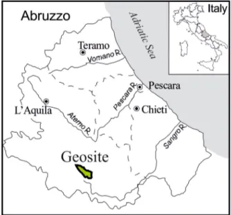
2. The Mount Serrone area (Gioia dei Marsi, Fucino Plain, Central Italy)
The Serrone ridge (in the Gioia dei Marsi municipality,
AQ, Abruzzo,Figure 1), mostly known in the area as
Mount Serrone, is located in the heart of the central Apennines. It is in the Marsica region, in the SE part of the Fucino intermontane basin and in the NW
Figure 1. Location map of the Mount Serrone fault Geosite (Gioia dei Marsi, AQ, Fucino Plain, Abruzzo, Central Italy).
edge of the Abruzzo, Lazio and Molise National Park. The Serrone (1305 m a.s.l.) ridge is NW-SE elongated and surrounded by parallel ridges, from 1300 to 2000 m a.s.l. in height. In the western side, a steep slope drops down to the Fucino plain, the largest inter-montane tectonic basin in Central Italy, once occupied by a large lake and reclaimed in 1876 for agricultural purposes.
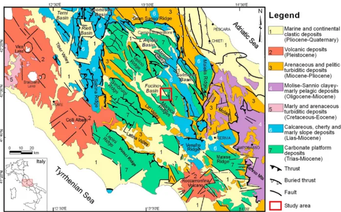
The central Apennines chain features several di ffer-ent landscapes shaped by a complex geological and geo-morphological history. It is the result of the Neogene– Quaternary evolution of an east-verging chain-fore-deep-foreland orogenic system forming large NW-SE thrust sheets, affected by uplift and extensional tectonics during the Quaternary (Patacca & Scandone, 2007; Cosentino, Cipollari, Marsili, & Scrocca, 2010; Piacen-tini & Miccadei, 2014; Santo et al., 2014; Piacentini et al., 2017). The chain is affected by strong recent seis-micity along the main NW-SE trending faults dissecting the thrust sheets (Figure 2;Vannoli, Burrato, Fracassi, & Valensise, 2012; Bonini, Di Bucci, Toscani, Seno, & Valensise, 2014;Gori et al., 2017a,2017b). The compet-ing endogenic (i.e. tectonic) and exogenic processes
connected to Quaternary climate fluctuations (i.e.
slope, karst,fluvial, weathering), led to the development of different types of landforms carved in a variety of rock types through time (D’Alessandro, Miccadei, & Piacen-tini, 2003;Piacentini & Miccadei, 2014).
Several million years ago (from Jurassic to Lower Cretaceous) an ancient shallow water sea occupied the whole area. On its seafloor, calcareous, fossil-rich, rocks were formed. Thereafter (Miocene-Pliocene), the rocks were lifted above the sea level by compres-sional tectonic pushes. Their deformation and stacking one above the other led to the emersion from the sea and to the creation of the first landscape, consisting of a moderate hilly relief (Colacicchi, 1967;Miccadei et al.,
2014 and references therein). Over the last 2 million
years (Pleistocene - Holocene), the whole area was affected by regional uplift and by several large scale NW-SE trending normal faults with strong connected seismicity. The combination of uplift and extensional
tectonics and surface processes (e.g. slope, fluvial,
karst, glacial) shaped the present landscape composed of steep, high elevation (>2500 m a.s.l.) faulted ridges and large intermontane tectonic basins, such as the Fucino plain (Ciccacci, D’Alessandro, Dramis, & Mic-cadei, 1999;Cavinato et al., 2002;Galadini et al., 2003; Ascione, Cinque, Miccadei, Villani, & Berti, 2008; Santo et al., 2014;Piacentini & Miccadei, 2014).
Located in the south-eastern side of the Fucino plain, the Serrone fault is part of the NW-SE oriented,
SW dipping Serrone–Parasano fault system. This
sys-tem has had a long-term and complex tectonic history being one of the main faults responsible for the cre-ation and shaping of the basin, once occupied by the greatest lake on the Italian peninsula (Galadini &
Messina, 1994;Galadini, Galli, & Giraudi, 1997; Cavi-nato et al., 2002;ISPRA, 2014;Miccadei et al., 2014).
On the 13 January 1915, a magnitude 7 earthquake (one of the strongest ever in Italy,Amoruso, Crescen-tini, & Scarpa, 1998; Rovida, Locati, Camassi, Lolli, & Gasperini, 2016) struck the area devastating the entire Marsica region and in particular the Fucino area (the damage reached Rome and the Adriatic coast). The Serrone fault - and its prosecution toward the Fucino plain - has been recognized as one of the normal faults ‘activated’ during the earthquake generating a 0,5–1 m high fault scarp. The surface evidence of this fault was observed right after the earthquake (Alfani, 1915; Oddone, 1915), and in several paleoseismological studies done in the last few decades on the SW slope of the Serrone (Serva, Blumetti, & Michetti, 1988; Gala-dini et al., 1997;Castenetto & Galadini, 1999;Amoroso et al., 2015;Gori et al., 2017a,2017b). The appearance of the fault scarp is not only results of tectonic pro-cesses but also of different geomorphological propro-cesses and it is also debated in terms of tectonic vs. other sur-face processes origin (e.g. soil erosion, landslides, sedi-ment compaction; Kastelic, Burrato, Carafa, & Basili, 2017). The area was also affected by large deep-seated gravitational slope deformations (Moro et al., 2012; Kastelic et al., 2017). However, these features resulting
from detailed scientific studies and debate (see Moro
et al., 2012;Kastelic et al., 2017and references therein) are not considered in the map, which is mainly focused on the tectonic features and earthquakes that affected the Serrone area.
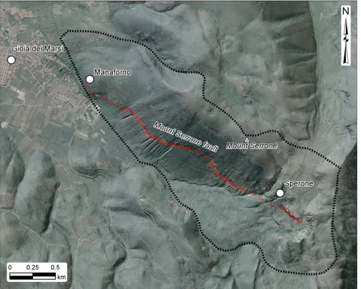
Here, the former Gioia dei Marsi village (once called Manaforno) and the nearby Sperone village were com-pletely ruined by the earthquake. Moreover, this fault system retrieves signs of recent tectonics and surface faulting referable to some of the strongest earthquakes, which occurred in central Italy in the last few centuries (Castenetto & Galadini, 1999;Gori et al., 2017a).
The main surface features of the fault (e.g. fault scarps, fault planes, contact between different rocks, heavy jointed and cataclastic rocks), as well as the remains of the Manaforno and Sperone villages, are still clearly visible along the Serrone SW slope. More-over, the area is easily accessible by car (Gioia dei
Marsi is 15 min from the A25 Parks’ Highway) and
an easy mountain trail runs along the slope of Mount Serrone (from Gioia to Sperone) and was recently restored by the Municipality.
3. The Mount Serrone fault Geosite
The identification of the fault scarp and the slope of
Mount Serrone as a Geosite was based on theISPRA
(2002) guidelines. The geosite was defined after the 1915 Fucino earthquake centenary for the high geologi-cal, geomorphological and historical values, in terms of
damaging. It is of primary geotourist interest and then of educational and landscape interest. Moreover, it is aimed at becoming a useful tool for the dissemination of the geological knowledge of the Abruzzi region and the Marsica territory in schools, for landscape-seismic hazard awareness and for the enhancement of local tourism in an area located right at the entrance of one of the most ancient national parks in Italy.
The Mount Serrone fault Geosite landscape is characterized by steep mountainous NW-SE ridges with a gently rolling top area, which drops down toward the Fucino basin along a steep slope. The top of the ridge is almost bare, while a heavy tree canopy covers the slope and particularly the lower part (Figure 3).
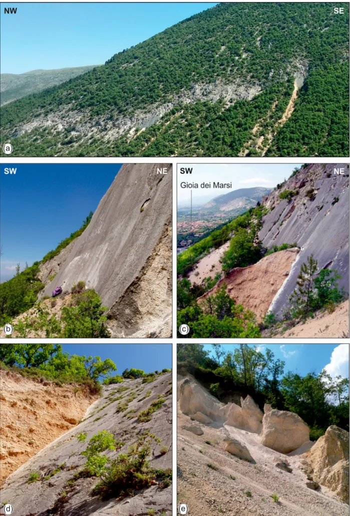
From the geological point of view, the geosite is fea-tured with marine Mesozoic and Cenozoic sedimentary calcareous and clay rocks, fault rocks and superficial deposits developed in subaerial environments due to gravity,fluvial-alluvial fan processes and karst weather-ing. Looking at the Mount Serrone slope from SW, a wide greyish band with no vegetation can be observed, located in the middle upper portion of the slope with
an arched shape (Figures 3and 4). It is composed of
several vertical and southwest dipping rock scarps and walls, which correspond to smooth fault planes (also called fault mirrors) as surface expression of
different segments of the Serrone fault (Figures 4and
5). The main fault is a normal fault (Figure 5(a)) com-posed of several fault planes with N45W-N60W strike orientation and 65°–40° SW dipping (Figure 4(b,c,d)). Along the fault, a wide cataclastic band is composed of
heavily jointed and ‘crushed’ calcareous rocks
deformed and resulting in a massive limestone breccia and sand (Figure 4(e)). In the lower part of the slope, talus slope deposits are onlapping onto the carbonate rocks along the fault plane (Figure 4(c,d)). The geo-morphological features outline a fault scarp at mid-elevation along the slope, which could be defined as fault generated mountain front as a whole (Vittori et al., 1991; Agosta, Prasad, & Aydin, 2007; Miccadei et al., 2014). The fault scarp was affected by surface faulting during the 1915 earthquake as documented right after the earthquake by Alfani (Figure 4(b)) and in paleoseismological studies, and thereafter by surface processes that locally exhumed the fault plains.
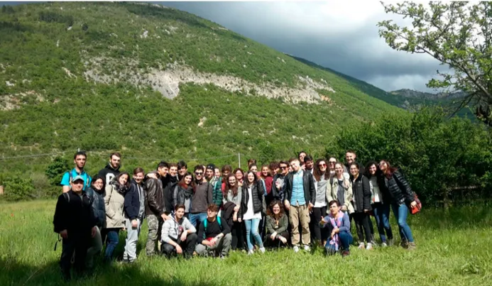
Due to its peculiar features, the Mount Serrone fault Geosite is meaningful for different types of activities: (i) geological and environmental education for school students, (ii) activities leading to greater awareness of natural hazards (i.e. seismic hazard) and (iii) tourism activities in general that focus on a sustainable approach to the exploitation of the landscape in a highly sensitive area. Here, several activities (e.g. workshops, conferences and seminars,field trips, school Earth science education projects) have been already realized (Figure 6) and others are planned, in collaboration with primary and high schools from the Abruzzo area and with the support of the Gioia dei Marsi Municipality and of the Mount Ser-rone Association. These activities, through the use of the geological tourist map, are focused on the present fea-tures of the geosite and of its landscape, which incorpor-ate and are connected to long-term (geological) and
short term (historical) memories of the landscape shap-ing and of the present geological hazards.
4. Methods and realization of the map
The geological tourist map is designed to establish an easy, guided visual connection between the landscape features and the geological heritage of the geosite and the observers or geotourists. To help simplify this
connection – particularly for children -, the reading
and understanding of the map is supported by a little girl named‘Gioia’, which is both the name of the
vil-lage and the Italian word for ‘joy’. She accompanies
the readers, as a geological guide, in an observation, comprehension and knowledge process of the geo-logical and tectonic features visible in the geosite’s landscape and along the trail helping the observer in the comprehension of the technical and scientific tasks. She helps to outline, with a smile, the faults as an element of Nature, but also to focus on the hazards and risks connected to faults and earthquakes that heavily affected the Gioia dei Marsi and the Fucino area.
The map incorporates previous data from geologi-cal mapping for defining the base map (ISPRA, 2014; Miccadei et al., 2014) and detailed geostructural investigations (Vittori et al., 1991). New investigations (field geological-geomorphological survey and aerial photo interpretation) were focused on defining the
geosite’s features and values and the best sites for
the geosite observation along the trails (in terms of geological exposures, their connection to the geologi-cal history of the landscape and their accessibility).
The map is double-sided and eight times foldable for afinal A5 folded size. The front is explanatory, the back is illustrative. On the front, complex features and pro-cesses, such as the long-lasting geological history and the earthquakes, are explained in an easy-to-under-stand language supported by charts and cartoons.
The back shows theMain Map, a simple visual legend,
a geological time scale and a cartoon of the Gioia dei Marsi-Sperone trail. The visual legend describes, with a color, an image and text, the different rock types that can be found in the Geosite area. The descriptions are headed by simple paraphrases outlining how, where, and when the rocks were formed, as well as
Figure 3.Mount Serrone fault Geosite (Gioia dei Marsi, AQ). Ortophoto and hillshade image of the Geosite area (black dotted line). The fault scarp is evident all along the Mount Serrone slope (red line). Ortophoto is provided by Regione Abruzzo cartographic office; DEM is provided by Ministry of Environment (National Cartographic Portal).
the main tectonic features (fault planes and fault rocks).
More specifically the front of the map is arranged in seven sections:
(1) an introductive part on the main features and rel-evance of the Mount Serrone fault Geosite; (2) definition of a fault;
(3) description and classification of the different types of faults (i.e. thrust, strike-slip, and normal faults) and their state of activity (‘good’ or ‘bad’ faults); (4) description of an earthquake;
(5) historical notes about the great 1915 Fucino earthquake, which changed the recent history of the Fucino area, focusing on the Gioia dei Marsi town and on the Manaforno and Sperone villages (Sinibaldi & Granato, 2015) (Figure 4); (6) health and safety guidelines in seismic areas, to be
followed before, during and after an earthquake, according to the guidelines provided by the Italian Civil Protection Agency (www.protezionecivile. gov.it);
(7) further readings provided for those interested in more scientific and technical details.
The back of the map is composed of:
(1) theMain Map(Figure 7), with a location map;
(2) the visual legend;
(3) a cartoon of the Gioia dei Marsi-Sperone trail; (4) a geological time scale outlining the main rocks
and the main steps of the >100-million-year geo-logical history of the geosite.
The map and the visual legend show that the back-bone of the Mount Serrone ridge is composed of lime-stone carbonate platform rocks formed in a shallow sea before the formation of the Apennines (Jurassic-Cretac-eous and Miocene, ca. from 100 million to 10 million years ago). Small patches of clay and sandstone rocks formed in a deep sea during the formation of the Apen-nines are also present (Late Miocene, ca. from 10 million to 5 million years ago;Colacicchi, 1967;Praturlon, 1968; Cavinato et al., 2002;ISPRA, 2014;Miccadei et al., 2014).
Figure 4.(a) Panoramic view of the Mount Serrone slope and of the entire geosite area; the fault scarp is outlined by the arch-shape grey band (red arrows) in the middle of the slope. (b) Sketch of the Mount Serrone slope, from the original manuscript of Padre Alfani (1915), while traveling in the Fucino area in the area affected by the earthquake. The upper line is the Mount Serrone profile, the mid line is the fault scarp, which Alfani observed on the slope, and the lower line marks the approximate location of the ancient village of Manaforno (thanks to the Ximenian Observatory, Florence).
Figure 5.The Serrone fault. a) Main fault scarp partly eroded by gully incision; b) main fault plane and rock scarp; c) fault scarp in the middle part of the fault, with ancient talus slope deposits onlapping onto and cut by the fault; d) close up of the talus slope deposits laying on one of the main fault planes; e) fault rock composed of crushed highly jointed limestones along the main fault.
Figure 7.Geological tourist map draped on a hillshade image. The fault scarp is evident all along the Mount Serrone slope. DEM for the hillshade image is provided by Ministry of Environment (National Cartographic Portal).
Figure 6.Field trip along the Mount Serrone fault Geosite for an educational project carried out by a high school from the Abruzzo area.
Along the Mount Serrone fault, limestone rocks are cov-ered by superficial deposits formed during the Quatern-ary period in a subaerial landscape (e.g. debris‘rolling’ along the slopes, alluvial gravel‘transported’ by stream water, red soils due to karst weathering of the limestone rock; age ranging Upper Pleistocene to Holocene, from 125,000 years ago to the present). The Mount Serrone fault scarps (‘mirrors’) and fault rocks are also described. This visual legend, together with a simplified geologi-cal time sgeologi-cale, helps the observer to outline the place and role of the different types of rocks and faults in the geo-logical history. The little girl‘Gioia’, along the Mount Serrone trail, travels an imaginary journey in geological time through the main geological steps that have led to the shaping of the present landscape. It begins from a Jurassic-Cretaceous shallow sea, moves to a Miocene deep sea, goes through the Miocene compressional tec-tonics and leads to the Quaternary extensional tectec-tonics and recent fault activity (with connected earthquakes, like the 1915 Fucino one), in competition with
Pleisto-cene to HoloPleisto-cenefluvial, slope and weathering surface
processes. This contributes to raising the awareness of the general public about the meaning and duration of ‘geological time’ and of the long-term geological history of the landscape.
5. Concluding remarks
The Geological tourist map of the Mount Serrone fault Geosite is a key tool in promoting the landscape as a resource for tourism and for geological hazard aware-ness. The Gioia dei Marsi and Mount Serrone area, at the entrance of the National Park of Abruzzo, Lazio, and Molise, is poorly known in terms of tourism, but rich in resources in terms of geological history and recent history of the Fucino and Marsica area (inner
Central Apennines). The geosite is defined along one
of the main faults connected to the 1915 Fucino earth-quake, historically, one of the strongest in Italy.
In the map, tectonics, faults and earthquakes are shown as a hazard but also as elements of Nature that have contributed to creating the landscape of the Apennines over geological time. The map establishes an easy and guided visual connection between the observers/geotourists and the landscape and geological heritage of the geosite. It incorporates long-term (geo-logical) and short term (historical) memories of the landscape shaping and of the present geological hazards. The exploitation of these connections pro-vides a useful tool (i) to understand how the landscape was formed through geological time, (ii) to establish the historical memories of the 1915 Fucino earthquake and of recent earthquakes, (iii) to be aware of the cur-rent hazards due to natural processes, especially
seis-mic ones, and finally (iv) to contribute to an aware
and responsible community. The history of the land-scape becomes something to be understood and
increases people’s awareness of geological processes. Through this awareness and proper land management, people learn to live with natural geological hazards.
Ultimately, through this type of map, the symbiosis between the activity of geotourism and the territory becomes an opportunity for tourism, cultural and cooperation activities, as well as being a powerful tool in education.
Software
The Main Map presented in this work was created
using Esri ArcGIS® 10.1 and overall layout of front
and back side of the map, as well as thefinal editing
work, was carried out with Corel draw X8 ®.
Acknowledgements
The authors wish to thank the Gioia dei Marsi Municipality for supporting the project. The map was realized under the auspices and patronage of ISPRA (Italian Institute for Environmental Protection and Research), INGV (National Institute of Geophysics and Volcanology), Italian Association of Geology and Tourism, AIGEO (Italian Association of Physical Geography and Geomorphology), and National Park of Abruzzo, Lazio, and Molise. We are grateful to the reviewers and to the Editor for the precious comments and suggestions that greatly improved the final version of the map and manuscript. A special thank goes to N. d’Intino for the realization of some drawings and schemes of the map. Topographic data and orthophoto images used in the paper and as a base map for theMain Mapare provided by Regione Abruzzo the‘Struttura Speciale di Supporto Sistema Informativo’ (http://www.regione.abruzzo.it/xcartografia/;
http://opendata.regione.abruzzo.it/catalog). Lidar data for the DEM processing are provided by Italian Ministry of the Environment and Protection of Land and Sea (MATTM)– National Geoportal (http://www.pcn.minambiente.it/ mattm/) and provided with license Creative Commons Attri-bution-ShareAlike 3.0 Italy (CC BY-SA 3.0 IT).
Disclosure statement
No potential conflict of interest was reported by the authors.
Funding
The realization of the map was supported by the Università degli Studi‘G. d’Annunzio’ Chieti - Pescara funds (Miccadei fund, Piacentini fund).
ORCID
Tommaso Piacentini http://orcid.org/0000-0002-5007-7677
Enrico Miccadei http://orcid.org/0000-0003-2114-2940
Monia Calista http://orcid.org/0000-0002-4525-5395
Cristiano Carabella http://orcid.org/0000-0001-9206-2812
References
Agosta, F., Prasad, M., & Aydin, A. (2007). Physical proper-ties of carbonate fault rocks, Fucino Basin (Central Italy): Implications for fault seal in platform carbonates. Geofluids, 7, 19–32.
Alcántara Ayala, I. (2009). Geomorphosite management in areas sensitive to natural hazards. In E. Reynard, P. Coratza, & G. Regolini-Bissig (Eds.), Geomorphosites (pp. 163–173). München: Pfeil.
Alfani, G. (1915). Appunti di viaggio del Padre G. Alfani sui luoghi maggiormente danneggiati dal terremoto del 13 gennaio 1915. In Manuscript of the Osservatorio Ximeniano archive (pp. 1–14). Firenze.
Amato, A., Arcoraci, L., Casarotti, E., Laucian, V., Meletti, C., Nostro, C.,… Postpischl, L. (2013). INGVterremoti: the communication is a risk, the silence is a fault. GNGTS 2013, Sessione 2.3, 343–348.
Amoroso, S., Bernardini, F. M., Blumetti, A. M., Civico, R., Doglioni, C., Galadini, F.,… Vittorini, E. (2015). Quaternary geology and Paleoseismology in the Fucino and L’Aquila Basins. 6th INQUA International Workshop. Geological Field Trips. Periodico semestrale del Serv. Geol. d’It. - ISPRA e Soc. Geo. It.
Amoruso, A., Crescentini, L., & Scarpa, R. (1998). Inversion of source parameters from near- and far-field obser-vations: An application to the 1915 Fucino earthquake, Central Apennines, Italy. Journal of Geophysical Research, 103, 29989–29999.
Ascione, A., Cinque, A., Miccadei, E., Villani, F., & Berti, C. (2008). The plio-quaternary uplift of the Apennine chain: New data from the analysis of topography and river val-leys in Central Italy. Geomorphology, 102, 105–118.
doi:10.1016/j.geomorph.2007.07.022
Badiali, F., Ilieş, D. C., & Castaldini, D. (2018). A tale of a city, through its urban landscape and cultural heritage in the heart of Europe: The case study of Oradea city (Romania). Geojournal of Tourism and Geosites, 21(1), 88–102.
Bertacchini, M., Benito, A., & Castaldini, D. (2007). Carta geo-archeo-turistica del territorio di Otricoli (Terni, Umbria). Geologia e Turismo - beni geologici e geodiversità. Atti del 3° congresso nazionale Associazione Italiana Geologia e Turismo, Bologna 1-2-3 marzo 2007, pp. 211-2-3–220.
Bissig, G. (2008). Mapping geomorphosites: An analysis of geotourist maps. Geoturystika, 3(14), 3–12.
Bonini, L., Di Bucci, D., Toscani, G., Seno, S., & Valensise, G. (2014). On the complexity of surface ruptures during nor-mal faulting earthquakes: Excerpts from the 6 April 2009 L’Aquila (central Italy) earthquake (M w 6.3). Solid Earth, 5(1), 389–408.
Brandolini, P., Canepa, G., Faccini, F., Robbiano, A., & Terranova, R. (2007). - Geomorphological and geo-environmental features of the Graveglia Valley (Ligurian Apennines). Geografia Fisica e Dinamica Quaternaria, 30, 99–116.
Brandolini, P., Faccini, F., Robbiano, A., & Bulgarelli, F. (2011). Geomorphology and cultural heritage of the Ponci Valley (Finalese karstic area, Ligurian Alps). Geografia Fisica e Dinamica Quaternaria, 34(1), 65–74. Carton, A., Coratza, P., & Marchetti, M. (2005). Guidelines
for geomorphological sites mapping: Examples from Italy. Géomorphologie: Relief, Processus, Environement, 11, 209–218.
Castaldini, D., Coratza, P., Bartoli, L., Dallai, D., Del Prete, C., Dobre, R.,… Zucchi, E. (2008). Carta Turistico
Ambientale del Monte Cimone, Parco del Frignano. Parco del Frignano, Eliofototecnica Barbieri, Parma. Castaldini, D., Valdati, J., Ilies, D. C., Barozzini, E., Bartoli, L.,
Dallai, D.,… Sala, L. (2005a). Carta Turistico Ambientale dell’Alta Valle delle Tagliole, Parco del Frignano. Parco del Frignano, Eliofototecnica Barbieri, Parma.
Castaldini, D., Valdati, J., Ilies, D. C., Chiriac, C., & Bertogna, I. (2005b). Geo-tourist map of the natural reserve of Salse di Nirano (Modena Apennines, northern Italy). Alpine and Mediterranean Quaternary, 18(1), 245–255.
Castenetto, S., & Galadini, F. (Eds.). (1999). 13 gennaio 1915: Il terremoto nella Marsica. Serv. Sis. Naz., CNR. Roma: Ed. IPZS.
Cavinato, G. P., Carusi, C., Dall’Asta, M., Miccadei, E., & Piacentini, T. (2002). Sedimentary and tectonic evolution of Plio-Pleistocene alluvial and lacustrine deposits of Fucino basin (Central Italy). Sedimentary Geology, 148, 29–59.
Ciccacci, S., D’Alessandro, L., Dramis, F., & Miccadei, E. (1999). Geomorphologic evolution and Neotectonics of the Sulmona Intramontane Basin (Abruzzi, Apennine, Central Italy). Zeirschrift für Geomorphologie. Suppl.-Bd., 118, 27–40.
Colacicchi, R. (1967). Geologia della Marsica orientale. Geologica Romana, 6, 189–316.
Coratza, P., & de Waele, J. (2012). Geomorphosites and natural hazards: Teaching the importance of geomorphol-ogy in society. Geoheritage, 4(3), 195–203. doi:10.1007/ s12371-012-0058-0
Coratza, P., Ghinoi, A., Piacentini, D., & Valdati, J. (2008). Management of geomorphosites in high tourist vocation area: An example of geo-Hiking maps in the Alpe di Fanes (Natural Park of Fanes-Senes-Braies, Italian Dolomites). Geojournal of Tourism and Geosites, Year 1, 2(2), 106–117.
Coratza, P., & Panizza, M. (Eds.). (2010). Geomorphology and cultural heritage. In Memorie Descrittive della Carta Geologica d’Italia, 87/2009 (pp. 1–190). Rome: ISPRA. Coratza, P., & Regolini-Bissig, G. (2009). Methods for
map-ping geomorphosites. In E. Reynard, P. Coratza, & G. Regolini-Bissig (Eds.), Geomorphosites (pp. 89–103). München: Pfeil.
Cosentino, D., Cipollari, P., Marsili, P., & Scrocca, D. (2010). Geology of the central Apennines: A regional review. In: Beltrando M, Peccerillo A, Mattei M, Conticelli S, Doglioni C (eds). The Geology of Italy: Tectonics and life along plate margins. Journal of the Virtual Explorer, 36(paper 11), 1–37.
D’Alessandro, L., Miccadei, E., & Piacentini, T. (2003). Morphostructural elements of central–eastern Abruzzi: Contributions to the study of the role of tectonics on the morphogenesis of the Apennine chain. Quaternary International, 101-102, 115–124.doi:10.1016/S1040-6182 (02)00094-0
Faccini, F., Gabellieri, N., Paliaga, G., Piana, P., Angelini, S., & Coratza, P. (2018). Geoheritage map of the portofino
natural park (Italy). Journal of Maps, 14(2), 87–96. Faccini, F., Roccati, A., & Firpo, M. (2012).– Geohiking map
of Mt. Penna and Mt. Aiona area (Aveto Park. Liguria). Journal of Maps, 8(3), 293–303.
Galadini, F., Galli, P., & Giraudi, C. (1997). Geological inves-tigations of Italian earthquakes: New paleoseismological data from the Fucino plain (Central Italy). Journal of Geodynamics, 24(1-4), 87–103.
Galadini, F., & Messina, P. (1994). Plio-Quaternary tectonics of the Fucino basin and surroundings areas (central Italy). Giornale di Geologia, 56(2), 73–99.
Galadini, F., Messina, P., Giaccio, B., & Sposato, A. (2003). Early uplift history of the Abruzzi Apennines (central Italy): available geomorphological constraints. Quaternary International, 101-102, 125–135. doi:10. 1016/S1040-6182(02)00095-2
Giaccio, B., Galli, P., Messina, P., Peronace, E., Scardia, G., Sottili, G.,… Silvestri, S. (2012). Fault and basin depocen-tre migration over the last 2 Ma in the L’Aquila 2009 earthquake region, central Italian Apennines. Quaternary Science Reviews, 56, 69–88. doi:10.1016/j. quascirev.2012.08.016
Gori, S., Falcucci, E., Galadini, F., Moro, M., Saroli, M., & Ceccaroni, E. (2017a). Geoarchaeology and paleoseismol-ogy blend to define the Fucino active normal fault slip his-tory, central Italy. Quaternary International, 451, 114–128.
Gori, S., Falcucci, E., Ladina, C., Marzorati, S., & Galadini, F. (2017b). Active faulting, 3-D geological architecture and Plio-Quaternary structural evolution of extensional basins in the central Apennine chain, Italy. Solid Earth, 8(2), 319–337.
Hose, T. A. (Ed.). (2016). Geoheritage and geotourism: A European perspective (heritage Matters). Suffolk: Boydell Press.
ISPRA. (2002). National Inventory of Geosites. Retrieved from http://www.isprambiente.gov.it/it/progetti/suolo-e- territorio-1/tutela-del-patrimonio-geologico-parchi- geominerari-geoparchi-e-geositi/il-censimento-nazionale-dei-geositi
ISPRA. (2014). Carta Geologica d’Italia (scala 1:50.000)
Foglio 378 “Scanno”. Roma: Servizio Geologico d’Italia, ISPRA.
Kastelic, V., Burrato, P., Carafa, M. M. C., & Basili, R. (2017). Repeated surveys reveal nontectonic exposure of suppo-sedly active normal faults in the central Apennines, Italy. Journal of Geophysical Research: Earth Surface, 122 (1), 114–129.
Marincioni, F., Appiotti, F., Ferretti, M., Antinori, C., Melonaro, P., Pusceddu, A., & Oreficini-Rosi, R. (2012). Perception and communication of seismic risk: The 6 April 2009 L’Aquila earthquake case study. Earthquake Spectra, 28(1), 159–183.
Miccadei, E., D’Alessandro, L., Parotto, M., Piacentini, T., & Praturlon, A. (2014). Note illustrative alla Carta Geologica d’Italia (scala 1:50.000), Foglio 378 “Scanno”. Rome: Servizio Geologico d’Italia, ISPRA.
Miccadei, E., Esposito, G., Innaurato, A., Manzi, A., Basile, P., & Berti, C. (2008). Carta Geologico-Turistica e relative “Note” della Comunità Montana Aventino-Medio Sangro - Zona Q (Provincia di Chieti, Abruzzo).
Miccadei, E., Piacentini, T., & Esposito, G. (2011). Geomorphosites and geotourism in the parks of the Abruzzo region (Central Italy). Geoheritage, 3(3), 233– 251.
Moro, M., Saroli, M., Gori, S., Falcucci, E., Galadini, F., & Messina, P. (2012). The interaction between active normal faulting and large scale gravitational mass movements revealed by paleoseismological techniques: A case study from central Italy. Geomorphology, 151-152, 164–174. Oddone, E. (1915). Gli elementifisici del grande terremoto
marsicano fucense del 13 Gennaio 1915. Bollettino Società Sismica Italiana, 29, 71–215.
Panizza, M. (2001). Geomorphosites: Concepts, methods and examples of geomorphological survey. Chinese Science Bulletin, 46, 4–6.
Panizza, M. (ed.). (2010). Un’escursione nello spazio e nel
tempo. Via GeoAlpina itinerari italiani [A field trip in
space and time. The GeoAlpina Way italian itineraries]. In APAT-ISPRA, G&T Associazione Italiana di Geologia e Turismo, EuroGeoSurveyes (pp. 1–292). Rome: CSR Publisher.
Panizza, M., & Piacente, S. (1993). Geomorphological asset evaluation. Z Geomorph, 87, 13–18.
Panizza, M., & Piacente, S. (2005). Geomorphosites: A bridge between scientific research, cultural integration and artis-tic suggestion. Il Quaternario, 18(1), 3–10.
Patacca, E., & Scandone, P. (2007). Geology of the southern apennines. Bollettino della Società Geologica Italiana, 7, 75–119.
Piacente, S., & Coratza, P. (2005). L’associazione Nazionale “Geologia & Turismo”. Per una nuova Prospettiva di svi-luppo culturale e sociale del turismo in Italia. Atti del Convegno“Giornate del turismo 2003”, Novara, 7-8 mag-gio 2003, 383-390.
Piacentini, T., Buccolini, M., & Miccadei, E. (2017). The Terminillo, Gran Sasso and Majella mountains: The“old guardians” of the Tyrrhenian and Adriatic seas. In M. Soldati, & M. Marchetti (Eds.), Landforms and landscapes of Italy. Book series geomorphological landscapes of the World. Migon P. Ed (pp. 327–337). Cham: Springer. ISBN 978-3-319-26194-2.
Piacentini, T., Castaldini, D., Coratza, P., Farabollini, P., & Miccadei, E. (2011). Geotourism: Some examples in northern-central Italy. GeoJournal of Tourism and Geosites, Year IV, 2(8), 240–262.
Piacentini, T., & Miccadei, E. (2014). The role of drainage systems and intermontane basins in the Quaternary land-scape of the Central Apennines chain (Italy). Rendiconti Lincei, 25(2 Supplement), 139–150. doi:10.1007/s12210-014-0312-2
Piacentini, T., Somma, M. C., Antonelli, S., Miccadei, E., Andreetti, E., Casolino, C.,… Tornese, T. (2018). Il “ven-taglio delle Terre Peligne”: percorso archeologico e geolo-gico in aree montane interne (Appennino abruzzese, Italia). In Atti del Convegno dell’Associazione Italiana di Geologia e Turismo, Il patrimonio geologico: una risorsa scientifica, paesaggistica, culturale e turistica, 7–8, June, 2018, Bologna (pp. 72–74). Bologna: Regione Emilia Romagna.
Pignone, M., Nostro, C., Amato, A., & Meletti, C. (2016). The role of the INGVterremoti blog in information manage-ment during the earthquake sequence in Central Italy. Annals of Geophysics, 59(FASTTRACK5), 1–8. doi:10. 4401/ag-7261.
Praturlon, A. (1968). Note illustrative del Foglio Geologico 152“Sora”, Carta Geologica d’Italia alla scala 1:100.000. Rome: Servizio Geologico d’Italia.
Regione Abruzzo. (2007). Regional topographic map of Abruzzo Region. Retrieved fromhttp://opendata.regione. abruzzo.it/content/dbtr-regione-abruzzo-scala-110000-edizione-2007-formato-shp
Regione Emilia-Romagna. (2009). Il Paesaggio Geologico dell’Emilia Romagna. Carta a scala 1: 250.000. Firenze: SELCA.
Reynard, E., & Brilha, J. (Eds.). (2017). Geoheritage. Assessment, protection, and management. Amsterdam: Elsevier. ISBN: 9780128095317.
Reynard, E., & Coratza, P. (Eds.). (2007). Geomorphosites and geodiversity: A new domain of research. Geographica Helvetica, 62(3), 138–191.
Reynard, E., & Coratza, P. (2016). The importance of moun-tain geomorphosites for environmental education: Examples from the Italian Dolomites and the Swiss Alps. Acta Geographica Slovenica, 56(2), 291–303.
Rovida, A., Locati, M., Camassi, R., Lolli, B., & Gasperini, P. (Eds.). (2016). CPTI15, the 2015 version of the Parametric Catalogue of Italian earthquakes. Rome: Istituto Nazionale di Geofisica e Vulcanologia. doi:http://doi.org/10.6092/ INGV.IT-CPTI15.
Sacchini, A., Imbrogio Ponaro, M., Paliaga, G., Piana, P., Faccini, F., & Coratza, P. (2018). Geological landscape and Stone heritage of the Genoa Walls Urban Park (NW Mediterranean, Italy). Journal of Maps, 14(2), 528–541.
Santo, A., Ascione, A., Di Crescenzo, G., Miccadei, E., Piacentini, T., & Valente, E. (2014)). Tectonic-geomor-phological map of the middle Aterno river valley (Abruzzo, Central Italy). Journal of Maps, 10(3), 365–378.
Scalise, A. R. (Ed.). (2017). Settimana del Pianeta Terra Itinerari geologico-ambientali. Week of Planet Earth geo-logical-enviromental itineraries. In Memorie descrittive
della Carta Geologica d’Italia,102/2017 (pp. 1–183). Roma: ISPRA.
Serva, L., Blumetti, A. M., & Michetti, A. M. (1988). Gli effetti sul terreno del terremoto del Fucino (13 gennaio 1915); tentativo di interpretazione della evoluzione tettonica recente di alcune strutture. Memorie Società Geologica Italiana, 35, 893–907.
Sinibaldi, C., & Granato, C. (2015). Il terremoto delle anime. Gioiaa dei Marsi AQ: Nuovo Corso Ed.
Vannoli, P., Burrato, P., Fracassi, U., & Valensise, G. (2012). A fresh look at the seismotectonics of the Abruzzi (Central Apennines) following the 6 April 2009 L’Aquila earthquake (Mw 6.3). Italian Journal of Geoscience, 131, 309–329. Vittori, E., Cavinato, G. P., Miccadei, E., Rughi, D., & Serva,
L. (1991). First results of a study on cataclastic and intense fracturing processes in calcareous rocks (Central Apennines, Italy). Bollettino Società Geologica Italiana, 110, 489–499.