Alma Mater Studiorum – Università di Bologna
Alma Mater Studiorum – Università di Bologna
DOTTORATO DI RICERCA IN
Scienze Ambientali: tutela e gestione delle risorse naturali
Ciclo _XXIII_
Settore Concorsuale di afferenza: ___04/A4_______ Settore Scientifico disciplinare:____GEO/12________
TITOLO TESI
Sea-level climate variability in the Mediterranean Sea
Presentata da: __Antonio Bonaduce_____
Coordinatore Dottorato
Relatore
Prof. Enrico Dinelli Prof.ssa Nadia Pinardi
_______________________
___________________
in the Mediterranean Sea
Student: Antonio Bonaduce
Advisor: Prof. Nadia Pinardi
Environmental Science
Alma Mater Studiorm-University of Bologna
A thesis submitted for the degree of
Doctor of Philosophy
Contents i
List of Figures iii
List of Tables viii
Abbreviations and Acronyms xi
1 Introduction 1
2 Low frequency sea-level variability over decadal period 5
2.1 Sea level from observational instruments . . . 5
2.2 Data . . . 8
2.2.1 In-situ data . . . 8
2.2.2 Remote-sensing data . . . 10
2.3 How to compare remote-sensing and in-situ data . . . 13
2.4 Comparison of in-situ and remote-sensing data . . . 17
2.5 Sea-level trend spatial variability . . . 25
2.6 Sea-level trend temporal variability . . . 26
2.7 Summary . . . 29
3 Sea-level variability over a centennial time period 30 3.1 Sea-level studies over a centennial time scale . . . 30
3.2 Data processing . . . 32
3.2.1 The tide-gauge dataset . . . 32
CONTENTS
3.3 Merging remote-sensing and in-situ sea-level signals: statistical
re-construction method . . . 35
3.3.1 EOFs selection . . . 38
3.4 Reconstruction validation for the satellite era . . . 42
3.5 Reconstruction validation before than satellite era . . . 44
3.5.1 Sea-level trends over decadal time scales . . . 48
3.6 Case study: the Tunisian coast . . . 51
3.7 Summary . . . 54
4 The Mean Sea-Level equation and its application to the Mediter-ranean Sea 57 4.1 Sea-level theoretical studies . . . 57
4.2 Mean sea-level equations (MSLEs): global and regional MSLs . . 58
4.3 Evaluation of the mean sea-level in the Mediterranean Sea . . . . 63
4.4 Summary . . . 70
5 Atmospheric pressure effects on sea-level variability over a med-imum range temporal scale 72 5.1 Sea-level response to atmospheric pressure . . . 72
5.2 Experiment design . . . 75
5.3 Italian tide-gauge network . . . 77
5.4 Atmospheric pressure data and inverse barometer effect . . . 77
5.5 Intercomparison between models and satellite data . . . 79
5.6 Intercomparison between models and tide-gauge data . . . 81
5.7 Summary . . . 92
6 Conclusions and future perspectives 93
Appendix A 96
2.1 Tide-gauge station distribution in the Mediterranean. Green points represent the tide-gauge stations having the most complete time series (at least 70 %) during the period between 1993 and 2010. . 10 2.2 Interannual steric component ηst
sat(t) of satellite altimetry data over
from 1993 to 2010; y-axis values expressed as [cm]. . . 14 2.3 ηst
sat(t) of satellite altimetry (green line) and steric signal obtained
subtracting the satellite gravimetry (GRACE) signal (black line) from the satellite altimetry signal; y-axis values expressed as [cm]. 15 2.4 SLA Time Evolution: tide-gauge and satellite altimetry
compari-son. From west to east across the basin; the cases of Mlaga (a), Ste (b), Marseilles (c), Dubrovnik (d), Valletta (e) and Hadera (f) are shown. . . 20 2.4 SLA Time Evolution: tide gauge and satellite altimetry
compari-son. From west to east across the basin; the cases of Mlaga (a), Ste (b), Marseilles (c), Dubrovnik (d), Valletta (e) and Hadera are shown. (f). . . 21 2.4 SLA Time Evolution: tide gauge and satellite altimetry
compari-son. From west to east across the basin; the cases of Mlaga (a), Ste (b), Marseilles (c), Dubrovnik (d), Valletta (e) and Hadera are shown. (f). . . 22 2.5 Satellite altimetry trend [mm yr−1] spatial variability in the
Mediter-ranean during the period 1993-2010. Steric signal removed, glacial-isostatic adjustment (GIA) applied. . . 26
LIST OF FIGURES
2.6 Satellite Trend as function of the length of the period considered. Panel (a) shows all the possible trends ending at the year indicated in the x-axis, obatained considering the number of years shown over the y-axis. Thus, considering the point x=2000 and y=10, it express the sea-level trend value up to the year 2000, obtained considering 10 years of data. Panel (b) shows the trend significance obtained performing a T-test; values below 80 % are not shown. . 28 3.1 Tide-gauge stations positions. In each panel the number and
po-sitions of tide-gauge stations used in the specific reconstruction period are shown. Red dots represent the total number of stations available in the specific temporal periods indicated above. Green dots indicate the actual amount of tide-gauge stations considered, representing the stations with the most complete time series. . . . 33 3.2 Optimal EOFs number selection. The x-axis is the number of
EOFs considered; the y-axis indicates the rmse [cm] obtained com-paring altimetry and reconstructions over the training period (2002 - 2010; blue line). The 2nd y-axis indicates as before the rmse [cm] between the two datasets obtained over the validation period (1993 - 2001; red line). . . 39 3.3 Satellite altimetry EOFs. . . 41 3.3 Reconstruction and satellite altimetry comparison (1993 - 2010).
Top panel: correlation map. Bottom panel: root mean square error [cm]; contour lines interval 1 cm. . . 42 3.4 Basin mean sea level [cm] from reconstruction (red line) and
satel-lite altimetry (green line). . . 44 3.4 Comparison between reconstruction and tide-gauges. . . 47 3.2 Spatial variability of trend. Top panel: reconstructed sea-level
trend during the period 1993 - 2010. Middle panel: difference between satellite altimetry and sea-level reconstruction trends, for the period 1993 - 2010. Absolute differences inferior to 2 mm yr−1 are not shown. Bottom panel: reconstructed sea-level trend during the period 1885 - 2010. . . 49
3.3 Sea-level reconstruction from 1885 to 2009: the red line shows the annual mean of sea-level reconstruction; the green line is the satellite altimetry annual mean during the period 1993-2009. The standard deviation range is shown with shading. . . 50 3.4 Change in reconstructed annual sea-level as a function of the length
of the period considered. Change is defined as the sea-level trend multiplied by the number of years over which the trend is estiamted [mmyr−1]. The y-axis expresses the length of the period considered (years) for estimating the trend; the x-axis indicates the ending year of the period considered. Year-by-year trends are not shown. 51 3.5 Study Area. . . 52 3.6 Satellite altimietry and sea-level reconstruction along the Tunisian
coasts. Top panels: satellite altimetry (right) and reconstructed sea-level trend spatial variability, for the period 1993 - 2010 [mm yr−1]. Bottom panels: sea-level reconstruction trend distribution for the period 1885 - 2010 (left)[mm yr−1]; satellite altimetry and recon-struction correlation pattern for the period 1993 - 2010 (right). . . 53 4.1 The notation of the paper and the system of reference: η is the
free surface and −H the bottom topography. . . 60 4.2 Mean sea-level tendency from re-analysis dataset. Top panel: mean
sea-level tendency contributions. Numbers refer to the terms of Eq. 4.13: transport at Gibraltar (1; green line), water flux (2; black line), halosteric term (3; cyan line), thermosteric term (4; violet line) and trasport of density (5; blue line). Middle panel: sea-level tendency mass and steric contribution. Mass and steric contribu-tions as resultant of terms (1) + (2) (red line) and (3) + (4) + (5) (black line) respectively. Bottom panel: resultant mean sea-level tendency (red line). Values expressed as [mm yr−1]. . . 65
LIST OF FIGURES
4.3 Comparison between sea-surface height and mean sea-level equa-tion terms (1) and (2). Top panel: integraequa-tion numerical error (black line), considering model data at each model time step (600 sec.). Bottom panel: sea-surface height model variable (solid blue line); water flux(1) and transport (2) time integration consider-ing the entire time window (1999 to 2001; dashed red line) and integrating between adjacent years (dashed green line). Values expressed as [mm yr−1] (monthly mean). . . 67 4.4 Mean sea-level tendency from model simulation data. Top panel:
mean sea-level tendency contributions. Numbers refer to the terms of Eq. 4.13: transport at Gibraltar (1; green line), water flux (2; black line), halosteric term (3; cyan line), thermosteric term (4; violet line) and the term due to the trasport of density (5; blue line). Middle panel: sea-level tendency mass and steric contribu-tion. Mass and steric contributions as resultant of terms (1) + (2) (red line) and (3) + (4) + (5) (black line) respectively. Bot-tom panel: resultant mean sea-level tendency (red line). Values expressed as [mm yr−1] (monthly mean). . . 69 5.1 Mean Winter (DJFM) North Atlantic Oscillation (NAO). Black
solid line show the smoothing applied to remove fluctuations with a period shorter then 4 years (Hurrell & Deser, 2009) . . . 75 5.2 MFS spatial domain. Blue dots indicate the positions of ISPRA
tide-gauge stations. . . 76 5.3 Mean sea-level time series from satellite observations (black line)
and simulations DA1 (red line), DA2 (green line), DA3 (blue line) and DA4 (purple line). Shaded areas show the two standard devi-ation range. . . 80 5.4 Mean sea-level time series from observations (black line) and
simu-lations DA1 (red line), DA2 (green line), DA3 (blue line) and DA4 (purple line). Shaded areas show the two standard deviation range. 82
5.5 Mean sea-level time series from observations with the inverse barom-eter correction applied (OBS-IBC; black line), and simulations DA1 (red line), DA2 (green line) that do not consider the atmo-spheric pressure contribution. Shaded areas show the two standard deviation range. . . 83 5.6 Inverse barometer effect applied to the tide-gauge stations (IBC;
black line) and deducted from model simulations for the filtered free surface (DA3-DA1; red line) and time-splitting (DA4-DA2; green line) formulations. Shaded areas show the two standard deviation range. . . 84 5.7 Spectral analysis. Top panel: datasets power spectrum, 80-day
band pass filter applied. The x-axis is expressed in months−1; x-axis indicating the frequency in months−1; y-axis energy expressed in m2. Bottom panel: sea-level signal obtained considering the low
frequencies, shown in the top panel. Black solid line refers to the tide-gauge dataset; red (DA1), green (DA2), blue (DA3) and purple (DA4) lines are model simulation datasets. . . 87 5.8 Spectral analysis. Top panel: datasets power spectrum, 80-day
low pass filter applied. The x-axis indicating the frequency in months−1; y-axis the energy expressed in m2. Bottom panel: mean sea-level signal obtained considering only residual high frequencies shown in the top panel. Black solid line is the tide-gauge dataset, red line represents the DA1 dataset, green line DA2, blue line DA3 and purple line DA4. . . 89 5.9 Observations and models power spectra. The first panel on the
top (OBS) shows tide-guage observations. The others panels from top to bottom show models DA4, DA3, DA2 and DA1. Colours indicate energy expressed as m2; the x-axis expresses the frequency
in months−1; the y-axis indicates the station number. . . 91 1 Revised Local Reference tide gauge stations distribution in the
List of Tables
2.1 Satellite altimetry data. Corrections applied to the AVISO satellite altimetry Delayed Time products (modified from (AVISO, 2010)). Missions: Topex/Poseidon (T/P), Jason-1/2 (J1; J2), ERS-1/2 (E1; E2), Envisat (En); *on=ongoing. *TOPEX Microwave Ra-diometer (TMR); *Microwave RaRa-diometer (MWR); *European Cen-tre for Medium-Range Weather Forecasts (ECMWF) . . . 12 2.2 Satellite altimetry and tide gauges data comparison at the
near-est point: sla considered removing the eta steric sat computed as a the spatialm mean of the satellite data,removing the temporal mean for the whole analysis period (1993 - 2010) and the inverse barometer effect from the tide gauges time series. Columns 1 to columns 3 represent the tide gauge stations metadata:n PSLMS code and geographical coordinates. Columns 4 express the per-centage of the time series completeness (%). Columns 5 to 7 show basic descriptive statistic of the data-sets comparison: correlation coefficient (C), root mean square error (RMS) and the root mean square error normalized for standard deviation (RMS*). Columns 8 and 9 show the sea level trends estimated by the tide gauges and satellite altimetry respectively [mm yr−1]. Column 9 is glacio-isosthatic adjustment correction applied to the estimated trends. . 24
3.1 Tide gauge stations RLR in the Mediterranean Sea, with time series that span a period longer 100 years. Columns 4 ad 5 express the period and the number of years covered by the station data. Columns 6 and 7 show the amout of data available once rmoved the missing data as numbers of yeasr and percentage (%) respectively. Column 8 indicates tide-gauges benchmarks [m] (see Appendix 1). We consider also the three tide gauges stations located in Venezia that considered togheter cover a period longer that 100 years. In Column 1, VENEZIA 1 correspond to Venezia Punta della Salute, VENEZIA 2 is Venezia Santo Stefano and VENEZIA 3 represent Venezia Arsenale. . . 34 3.2 Variance accounted by EOFs (%) . . . 40 3.3 Reconstruction and Altimetry comparison in target areas along
the Tunisian Coast. Column 3 show the correlation coefficient (C) between the altimetry and the reconstruction time series. Columns 4 and 5 refer to the reconstruction trends computed over the period 1885 - 2010 and 1993 - 2010, respectively. Values expressed in mm yr−1. . . 54 5.1 NEMO OGCM Configurations and Experiments set up. DA1
and DA2 experimens use the Filtered Free Surface and the Time-Splitting surface pressure gradient formulations respectively, with-out considering the atmospheric pressure at open lateral boundary conditions. DA3 and DA4 experiments have the same surface pres-sure gradient formulations of the previous two experiments, but consider the atmospheric pressure vertical boundary conditions. . 77
LIST OF TABLES
5.2 Mean sea level from model simulations and observations. C is cor-relation pattern coefficient; RMS is the root mean square error [m]. From top to bottom: tide-gauges full signal (OBS) compared with all the models simulations sea-level signals (Figure 5.4); in-verse barometer correction applied to observations (OBS-IBC) and compared with model simulations (DA1 and DA2) where the the atmosheric pressure is not considered (Figure 5.5); inverse barom-eter correction (IBC) applied to the observations and subtracted from model simulations (DA3-DA1; DA4-DA2; Figure 5.6). . . 84 5.3 Observations and model power spectra (Figure 5.7 and 5.8). The
table indicates the energy content (E) expressed in m2, and the variance accounted (V ar) as a pecentage (%), by the frequencies indicated in the first column (M onth−1). . . 85 5.4 Model simulation and observation comparison in terms of mean sea
level, where C is the correlation coefficient and RMS is the root mean square error . Column 1 and 2 (Full) refer to the comparison of the mean sea-level signal of observations and simulations, as shown in Figure 5.4. Columns 3 and 4 (Low) shown the results applying a high-frequencies band pass filter to the data (Figure 5.7). Columns 5 and 6 are the results obtained considering only the residual frequencies of the sea-level signals (Figure 5.8). . . 86 1 Tide gauge stations RLR in the Mediterranean sea, with time
se-ries that span a period longer 100 years. Columns 4 ad 5 express the period and the number of years covered by the station data. Columns 6 and 7 show the amout of data available once rmoved the missing data as numbers of yeasr and percentage (%) respec-tively.Column 8 indicates tide-gauges benchmarks [m]. . . 101
hIB Inverse Barometer Effect
AV ISO Archiving, Validation and Interpretation of Satellite Oceanographic Data CAN T ICO Climate and ANthropogenic drivers and impacts for the TunisIan
COastal areas
EGW s External Gravity Waves EKE Eddy Kinetic Energy
EuroGOOS European Global Ocean Observing System GIA Glacial Isostatic Adjustment
GM SL Global Mean Sea Level
GOOS Global Ocean Observing System ICZM Integrated Coastal Zone Management
IP CC Intergovernamental Panel on Climate Change
ISP RA Italian Institute for Environmental Research and Protection M F S Mediterranean Forecasting System
OP A Mean Sea Level Equations M SLP Mean Sea Level Pressure N AO North Atlantic Oscillation
LIST OF TABLES
N CEP National Center for Atmospheric Research N CEP National Centers for Environmental Prediction N EM O Nucleus for European Modelling of the Ocean OGCM Ocean General Circulation Model
OP A Ocean PArallelise code
SDE Stochastic Differential Equation T P Topex/Poseidon
Introduction
Sea-level variability is characterized by multiple interacting factors described in the Fourth Assessment Report (Bindoff et al., 2007) of the Intergovernamental Panel on Climate Change (IPCC) that act over wide spectra of temporal and spatial scales. Over time scales ranging from centuries to millenia, a leading role is played by very slow and continuous processes such as lithospheric and mantle deformation due to the the melting of ice sheets inducing the process of glacio-isostatic adjustment (GIA) (Spada et al., 2006), giving a contribution to sea-level trends. Sea-level changes at decadal and interannual time scales are due to density and water-mass distribution variations in the ocean, driven by wind, atmospheric pressure (Chapters 2 and 5) and heat and water fluxes. Wind stress and pressure produce, through mechanical stress, a displacement of the water mass involving sea-level variations due to barotropic displacement of the water column. Variations of temperature and salinity due to heat and water fluxes tend to modify the density structure of the water column (the steric effect), which in turn changes the height of the water column.
Sea-level changes in the global ocean are mainly driven by water flux (precip-itation, evaporation, river run-off and ice melting), which represents the sea-level variability component due to mass variations, and by heat flux, which accounts for the steric component (Chapter 4). The most recent study on global sea level estimates a global sea-level rise of 3.2 ± 0.4 mm yr−1 from satellite altimetry and 2.8 ± 0.8 mm yr−1 from in-situ data during the period between 1993 and 2009, while the linear trend obtained from Global Mean Sea Level (GMSL)
recon-struction (Chapter 3) during the period from 1900 to 2009 is 1.7 ± 0.2 mm yr−1 (Church & White, 2011).
At the regional scale, lateral fluxes also contribute to sea-level variability, adding complexity to sea-level dynamics (Chapter 4). In the case of the Mediter-ranean, Marcos & Tsimplis (2007) estimates a trend of 0.9 ± 0.4 mm yr−1 from in-situ data for the period 1960-2000. The first Mediterranean sea-level recon-struction was realized by Calafat & Gomis (2009) for the period 19452000, giving a trend of 0.7 ± 0.2 mm yr−1.
In Church et al. (2010) sea-level variability and changes are defined as manifes-tations of climate variability and change. The European Environmental Agency (EEA) defines sea level as one of most important indicators for monitoring cli-mate change, as it integrates the response of different components of the Earths system and is also affected by anthropogenic contributions (EEA, 2011). This last aspect can be explained by human activities that contribute to groundwa-ter storage. Human-induced sea-level rise is mainly due to the concentration of the world population along the coasts: the development of mega-cities and the concentration of human activities in these areas have lead to wetland loss and subsidence mainly as a result of the overuse of groundwater (Nichols, 2004). This process is responsible for increased salt-water intrusion into aquifers (Nicholls & Mimura, 1998), thus establishing a positive feedback between the exploitation of resources and environmental impact. High demographic density in coastal areas tends to amplify the effects of extreme events such as hurricanes and storm surges, which are the main drivers of coastal flooding events (such as Katrina along the Louisiana coast in 2005).
In this context, Integrated Coastal Zone Management (ICZM) as promoted since 1995 by the Barcelona Convention assumes increasing importance. The United Nations Framework Convention on Climate Change (UNFCCC)(COP17, Durban, South Africa, 2011) underlines the importance of integrated management of coastal zones (Article 4 of the UNFCCC 1) as an adaptation to the impact of climate change and the uncertainty it causes.
The balance between the different sea-level contributions represents an impor-tant source of uncertainty, involving stochastic processes that are very difficult to
in particular if we look at possible responses to sea-level contributions to future climate.
The study of historical sea-level data is a means for understanding and quan-tifying these many uncertainties (Church et al., 2010). The development over the last 20 years of satellite altimetry has radically improved our capacity to under-stand sea-level dynamics at the global (Cabanes et al., 2001) and regional (Pujol & Larnicol, 2005) scales.
The advent of operational oceanography has had a major impact on numerical models of large-scale circulation (Oddo et al., 2009), as they can now be accu-rately calibrated with observed data. The development of real-time monitoring systems, such as the Global Ocean Observing System (GOOS) and EuroGOOS for the European seas, allows the realization of high-resolution global (Masina et al., 2004) and regional (Adani et al., 2010) ocean re-analysis, realized with a relevant number of observations and calibrated models. Both model calibration with observed data and the continuous improvement of the physical represen-tation of oceanic processes allow models to simulate the sea-level variability at global and regional scales realistically.
The research strategy adopted in this work to approach such an interesting and challenging topic has been to develop an objective methodology to study sea-level variability at different temporal and spatial scales, applicable in each part of the Mediterranean basin in particular, and in the global ocean in general, using all the best calibrated sources of data (for the Mediterranean): in-situ, remote-sensig and OGCM data. In-situ data time series cover the last century with monthly records, while altimeter data is available only since the beginning of the nineteen-nineties. The balance between sea-level observational data availability, used also to validate numerical model outputs, and the temporal scales of the main sea-level change drivers (i.e., GIA, density and water-mass distribution variations), has led to structuring this study in such a way as to look at sea-level variability over temporal scales that range from monthly to decadal up to multidecadal.
The global objective of this work was to achieve a deep understanding of all of the components of the sea-level signal contributing to sea-level variability,
tendency and trend and to quantify them.
Chapter 2 presents a study of sea-level variability in the Mediterranean basin at a decadal time scale using in-situ and remote sensing data. Sea-level variability is investigated at a centennial time scale, using sea level reconstruction techniques in Chapter 3. Chapter 4 describes the fully consistent Mean Sea Level Equation and its application in the Mediterranean basin. Chapter 5 presents a study of the atmospheric pressure effect on the sea-level signal using numerical models of large-scale circulation and in-situ data.
Low frequency sea-level
variability over decadal period
2.1
Sea level from observational instruments
The problem of rising global sea levels has attracted a great deal of attention over the past ten years. The difficulties in estimating a reliable rate of sea-level change are due mainly to two categories of factors: the dataset used (whether tide gauges or satellite altimetry) and the period for which the rate is estimated. Before the beginning of what is known as the satellite era (1992 onwards) and the availability of a certain number of years of data, sea-level trends were estimated using long time series of tide-gauge data. Today, the availability of satellite altimetry data spanning a period of under 20 years means that trends are also estimated over shorter periods. Thus, differences in the dataset and time period considered means that many different sea-level rise values are given both at the global and regional scales.
Global sea-level trends are dominated by the steric component and ocean mass increase (Levitus et al., 2000; Domingues et al., 2008). Coastal and island tide-gauge data show that sea levels rose by just under 20 cm between 1870 and 2001, with an average rise of 1.7 mm yr−1 for the period 1950-2000 (Holgate, 2004). The first global sea-level reconstruction (Church et al., 2004a), covering the period 1950-2000 is an agreement with the previous value, proposing a global sea-level
2. Sea level from observational instruments
rise of 1.8 ± 0.3 mm yr−1 between 1950 and 2000. Extending the reconstruction period to between 1870 and 2004, Church (2006) found that the total global mean sea-level rise is 195 mm, an average of 1.44 mm yr−1, and that for the 20th cen-tury the rise is about 160 mm at a rate of 1.7 ± 0.3 mm yr−1, also considering in the error the effect of glacial isostatic adjustment (GIA). By dividing the analysis period into two sub-periods, 1870-1935 and 1936-2001 (change of slope ∼ 1930), and performing linear regressions on the two halves of the records,Church (2006) found that the slopes are 0.71 ± 0.40 and 1.84 ± 0.19 mm yr−1 respectively, implying an acceleration of 0.017 ± 0.007 mm yr−2 in the last 65 years.
Since the end of 1992, near-global measurements of sea levels (between 60◦ N and 60◦ S) made by high-precision satellite altimeters have been available. In Cazenave et al. (2003) Topex/Poseidon data indicate global average sea level has risen at 3.2 ± 0.4 mm yr−1 between 1993 and 1998 and 2.4 ± 0.1 mm yr−1 between 1992 and 2001. Cabanes et al. (2001) also used Topex/Poseidon data, and applied a low pass filter at each grid point to remove short-period (≤1 year) signals; a rate of global sea-level rise of 2.5± 0.2 mm yr−1 between January 1993 and December 2000 was found. In the sea-level rate values estimated in both Cabanes et al. (2001) and Cazenave et al. (2003), the GIA contribution is not subtracted. According to Leuliette et al. (2004), the GIA should be subtracted from the global average trend of 2.8 ± 0.4 mm yr−1, found using Topex/Poseidon and Jason data for the period 1992-2004, with a mean rate value of - 0.3 mm yr−1 (Douglas & Peltier, 2002).
In the Mediterranean, atmospheric pressure has a strong influence on sea-level trends (Tsimplis et al., 2005; Marcos & Tsimplis, 2007; Gomis et al., 2008). Tsimplis et al. (2005) calculated trend, corrected for meteorological effects, using the 9 longest time series of tide-gauge station data available in the Mediterranean basin (located in the western basin and Adriatic Sea). For the period 1958 to 2001, a sea-level rise varying from ∼ 0.3±0.4 mm yr−1 to ∼ 1.3±0.4 mm yr−1 was found, though between 1993 and 2001 the tide-gauge stations in the Adriatic show residual trends of 5 to 10 mm yr−1.
In Marcos & Tsimplis (2007) the data of 11 tide-gauge stations (located in the western part of the basin as well as in the Adriatic) were used to compute the basin mean sea-level trend between 1960 and 2000 (∼ 0.9 ±0.4 mm yr−1), taking
the atmospheric forcing effect into consideration(- 0.7±0.1 mm yr−1) and correct-ing the residual trend for post-glacial rebound processes (- 0.2±0.3 mm yr−1). Marcos & Tsimplis (2008), using 21 tide-gauge stations with more than 35 years of data, estimated the sea-level trends corrected for meteorological effects for the period 1960-2000 underlying the sea-level trend variability found in the basin: between 2.0 and 2.2 ± 0.4 mm yr−1 along the northern Spanish coast, between 0.0 ± 0.2 and 0.7 ± 0.2 mm yr−1 in the western basin and between 0.4 ± 0.3 and 0.9 ± 0.3 mm yr−1 in the Adriatic.
Klein & Lichter (2009) divided the tide-gauge time series into two sets of records (up to 1959 and from 1960 onwards), finding that trends (obtained cal-culating linear regressions on the time series) in the Mediterranean over the 20th century have been quite similar to the average global sea-level rise (0.5 - 2.5 mm yr−1), but for the sub-period 1990-2003 (filtering out the atmospherical contribution from the data) in most of the Mediterranean (twenty-one out of twenty-nine stations analysed), the trends are 5 to 10 times higher than the 20th century mean.
Cazenave et al. (2002), using Topex/Poseidon data from 1993 to 1998 and ERS-1/2 data from 1992 to 1996 (seasonal signal removed and low pass filter applied at each grid point), estimated a mean basin sea-level rise for the period 1993 - 1998 of 7 ± 1.5 mm yr−1. In their previous study Cazenave et al. (2001), using Topex/Poseidon data only (filtered as in Cazenave et al. (2002)) from 1993 to 1999, it was shown how the Western basin (5 to 10 mmyr−1) and the Levantine Basin (average rates of ∼ 20 mmyr−1) have been continuously rising over this period, while the Ionian Basin shows evidence of sealevel falls reaching a rate of -10 mmyr−1, marking the start of an important change in the circulation observed in this basin (Demirov & Pinardi, 2002).
The first sea-level reconstruction for the Mediterranean Sea to use both satel-lite and tide-gauge data was realized by Calafat & Gomis (2009) for the pe-riod 1945-2000, estimating the basin-averaged trend over 55 years at 0.7 ± 0.2 mm yr−1, finding, even in this case, differences between the various sub-basins: a positive trend (1.2 mm yr−1) is obtained for the Ionian Sea, whereas a negative trend was observed for the previous period, with a negative peak in the Levantine Basin (- 0.5 mm yr−1, south-east of Crete). The results between 1993 and 2000
2. Data
are significantly different: positive trend values above 10 mm yr−1 were found in the eastern Mediterranean and smaller rates (less than 5 mm yr−1) in the western Mediterranean. A marked negative trend of more than -15 mm yr−1 is observed in the Ionian.
Looking at this marked spatial-temporal variability of the sea level in the basin, one of the specific purposes of this work is to describe and understand the sea-level variability in the Mediterranean using all available best-calibrated observational data-sets for a common period in order to obtain consistent results. To acheive this objective, two sea-level observational datasets have been consid-ered, comparing 18 years of data (1993 - 2010): 1) for tide-gauges, the Revised Local Reference data-set, provided by the Permanent Service for Mean Sea Level (PSMSL); 2) the Delayed Time Sea Level Anomaly (DT SLA) data-set from the AVISO agency.
A second objective of this analysis is to evaluate how satellite altimetry data resolve the sea level near the coasts, in order to understand if the offshore sea-level altimetry signals are representative of the local sea level recorded by tide-gauges along the basin coasts.
The reminder of this chapter is organized as follows. In Section 2 we select the data to be used in the sea-level signal analysis. The method used to compare the tide-gauge and satellite altimetry datasets is described in Section 3. The coastal sea level from tide gauges and the open-ocean sea level from altimetry are compared and analysed in Section 4: first we look at the correlation between the two datasets and at the sea-level trends estimated from both; in the second part of this section, the sea-level trend spatial and temporal variability is analysed using satellite altimetry data. All the results are summarized in Section 5.
2.2
Data
2.2.1
In-situ data
The PSMSL data set is available from around 1900 and up to 2008 but has a discontinuous spatial distribution and a significant gap in the southern part of the basin (North Africa). In-situ sea-level data are provided by the PSMSL as
monthly means. In particular, attention will be i focused on the Revised Lo-cal Reference (RLR) dataset (Woodworth & Player, 2003), which, for scientific purposes, results as superior to simple metric data. The PSMSL reduces all the records collected to a common datum for the analysis of time series. This reduc-tion is performed using the tide-gauge datum history and a common denominator of 7000 mm below the average sea level (Klein & Lichter, 2009) , in order to avoid negative numbers in the resulting RLR monthly and annual mean values.
In the Mediterranean basin there are 63 tide-gauge stations of the RLR dataset covering the period between 1993 an 2010 (satellite time window). Only half of these show complete time series: in particular, 31 stations have at least 70 % of the complete time series during the analysis period. In Figure 2.1 the spatial distribution of tide-gauge stations over the basin is shown: green points represent the stations with the most complete time series. These stations represent the target areas selected for this study (Table 2.2).
2. Data
Figure 2.1: Tide-gauge station distribution in the Mediterranean. Green points represent the tide-gauge stations having the most complete time series (at least 70 %) during the period between 1993 and 2010.
2.2.2
Remote-sensing data
The specific satellite Sea Level Anomaly (SLA) fields used in this study are de-scribed by Pujol & Larnicol (2005). Data are interpolated over a regular grid every 7 days using an objective method combining the different altimeter mis-sions (Ducet et al., 2000; Pujol & Larnicol, 2005). It uses a debiasing filter for along-track long wavelength (Traon et al., 1998, 2003) and the subtraction of the inverse barometer effects as well as wind and tidal effects, ionosphere correction and wet and dry troposphere corrections (see Table ??), electromagnetic bias, instrumental corrections (altimeter bias and onboard oscillator drift). We used
a homogeneous data set based on 6 satellites: Topex/Poseidon (September 1992 to October 2005) , Jas1 (August 2002 onwards), Jas2 (January 2009 on-wards), ERS-1 (October 1992 to May 1995), ERS-2 (May 1995 to June 2003), Envisat (June 2003 onwards). Starting with different satellite along-track data, the different SLA signals of the satellite missions named above are combined and interpolated through an objective analysis technique on a regular grid (Ducet et al., 2000) with a horizontal resolution of 1/8◦ (∼ 13 km). Along-track data are truncated at a distance of ∼ 30 km from the coast to avoid reflection of the radar signal from the land: this value has been considered as the distance from the coast to define the minimum area around each tide-gauge position for data inter-comparison. Data has been averaged monthly in order to use the same temporal resolution as the in-situ data.
2. Data T/P J1 J2 E1 E2 En Data p erio d 1992-2 005 2002-on * 2009-on 1992-1995 1995-200 3 2003-on Ionosfere dual frequency dual frequency Ben t mo del dual frequency altimeter range altimeter range altimeter range measuremen ts (T op ex), measuremen t m easuremen t from Doris (P oseidon) W et T rop oshere TMR * ECMWF * MWR * applied ECMWF Dry T rop oshere ECMWF ECMWF EC MWF ECMWF In v erse Barometer ECMWF ECMWF ECMWF ECMWF Ocean Tide applied P ole Tide W ahr (1985 ) Solid Earth Ti de Elastic resp onse to tidal p oten tial (Cart wrigh t & Edden , 1973 ) Loading Tide applied T able 2.1: Satellite altimetry data. Corrections applied to the A VISO satellite altimetry Dela y ed Time pro ducts (mo dified from (A VISO , 2010 )). Missions: T op ex/P oseidon (T/P), Jason-1/2 (J1; J2), ERS-1/2 (E1; E2), En visat (En); * on=ongoing. * TOPEX Micro w a v e Radiometer (TMR); * Micro w a v e Radi ometer (MWR); * Europ ean Cen tre for Medium-Range W eather F ore casts (ECMWF) .
2.3
How to compare remote-sensing and in-situ
data
In order to compare satellite SLA and tide-gauge sea-level data we will start defining the sea-level anomaly (SLA) signal. The SLA is given by the difference between the sea level (ηsat) and its mean (ηsatmean), calculated over a reference
period running from 1993 to 1999 (Pujol & Larnicol, 2005). We assume that ηsatmean contains the geoid and the mean dynamic topography and we write:
slasat(x, y, t) = ηsat(x, y, t) − ηmeansat (x, y) (2.1)
where ηsat(x, y, t) can be defined as:
ηsat(x, y, t) = ηsatst (t) + ηmeansat (x, y) + ηvarsat(x, y, t)(2.2)
where ηst
sat(t) is the sea level steric component defined as a time-dependent
function only (Mellor & Ezer, 1995), and ηvar
sat(x, y, t) is the time- and
space-dependent dynamic component. From 2.3 it is evident that if the time average is defined for the same period as ηmean
sat , hηsatst i = 0, where the brackets indicate the
time average.
We define the steric component of satellite sea level as:
[[slasat(x, y, t)]] = ηsatst (t) (2.3)
where the square brackets indicate area average. ηst
sat(t) is monthly mean
frequency and we obtain the seasonal steric signal, which we call ηst
sat, shown in
2. How to compare remote-sensing and in-situ data
1993
1995
1997
1999
2001
2003
2005
2007
2009
−10
−5
0
5
10
Figure 2.2: Interannual steric component ηst
sat(t) of satellite altimetry data over
from 1993 to 2010; y-axis values expressed as [cm].
The steric effect is considered as a time-dependent variable only, following the definition of Greatbatch (1994) and Mellor & Ezer (1995). It assumes that the local elevation change exclusively due to density change is rapidly distributed over the entire domain with a time scale proportional to the basin lateral scale and the barotropic wave speed (Mellor & Ezer, 1995). This definition assumes great importance in a regional basin, where lateral advection can arise variations of density not associated to real variations of the external forcings (i.e., heat and water fluxes; Greatbatch, 1994 ), which in turn should be the source of steric variations considered as anomalies of water-column density (Mellor & Ezer, 1995). This effect is also minimized considering the steric signal as a basin-averaged time-dependent variable.
To validate the steric signal obtained, the satellite steric term ηsatst has been compared with the steric signal obtained subtracting the satellite gravimetry sea-level signal (GRACE), which accounts for the mass-induced sea-level signal variation, from the satellite altimetry data (Garcia et al., 2006). Garcia et al. (2010) define the sea-level signal (represented by satellite altimetry) as the result of the steric and mass component, SLT OT = ηsteric+ ηmass, defining the deduced
steric component as, ηsteric = SLT OT − ηmass . Figure 2.3 shows the signal
de-scribed above (black line) and the ηst
sat(t) signal (green line). The two curves are
very similar, with differences in minimum (2005 and 2006) and maximum peaks (2007), probably due to the coarse resolution of gravimetry data (1 ◦) which does not allow the resolution of the total intra-annual variability of the steric signal in the Mediterranean.
2003
2004
2005
2006
2007
2008
−10
−5
0
5
10
steric−10
−5
0
5
10
−2
0
2
NA O inde x Figure 2.3: ηstsat(t) of satellite altimetry (green line) and steric signal obtained
subtracting the satellite gravimetry (GRACE) signal (black line) from the satellite altimetry signal; y-axis values expressed as [cm].
Just as we did in equation (2.3), we can define the sea level measured by the tide gauges as
2. How to compare remote-sensing and in-situ data
ηins(xi, yi, t) = ηsatst (t) + η IB(x
i, yi, t) + ηinsmean(xi, yi) + ηinsvar(xi, yi, t) + C (2.4)
where xi, yi are the station coordinates, ηins(xi, yi, t) the in-situ local mean
sea level, ηst
sat(t) the sea-level steric component, ηIB(xi, yi, t) the inverse
barom-eter effect, ηmean(x
i, yi) the mean dynamic topography over the same reference
period (1993 - 1999), ηinsvar(x, y, t) the time- and space-dependent local sea-level component and C the local datum correction. The local datum correction is computed removing the temporal mean from each tide-gauge station time series. As said in Sub-section 2.2.2, the inverse barometer effect is removed from the altimetry data, and this correction is therefore applied to the tide-gauge data to compare the two signals, considering the inverse barometer effect as described in Dorandeu & Le Traon (1999a):
ηIB(xi, yi, t) = −
1
ρg(P a(xi, yi, t) − P aref(t)) (2.5) where ρ is the sea water density, P a the mean seal-level pressure (MSLP), re-trieved from the European Centre for Medium-Range Weather Forecasts (ECMWF) Re-analysis dataset (ERA-Interim), for the tide-gauge position, and P aref is the
MSLP spatial mean over the Mediterranean basin computed during the period 1993-2010. Removing this component from the sea level measured by the tide gauges we obtain:
η∗ins(xi, yi, t) = ηins(t) − ηIB (2.6)
If we now consider the period 1993-2010 (rather than the reference period 1993-1999), it results that the temporal mean of slasat and ηins are:
hslasati 6= 0 = α (2.7)
hηins∗ i = ηmean ins +η
st
sat + C = β (2.8)
To compare the two datasets we therefore subtract ηst
from the satellite and tide-gauge data, obtaining:
sla0 = slasat− ηsatst (t) − α (2.9)
ηins∗0 = ηins∗ − ηst
sat(t) − β (2.10)
The sea-level signals sla0 and ηins∗0 , which account for the low-frequency sea-level variability over the decadal time scale, are used to compare the two datasets in the different parts of the basin during the period between 1993 and 2010.
2.4
Comparison of in-situ and remote-sensing
data
This part of the analysis has been realized comparing the time series of the two observational data sets, considering the altimetry-gridded data interpolated over the tide gauges geographical positions (see Table 2.2). The interpolation has been carried out considering at least four grid points around the tide-gauge coordinate, and assigning weights to each one according to their distance from the station position.
Taking into consideration the error associated with the satellite altimetry measurements near the coasts due to the cutting of satellite tracks along the coasts to avoid land reflection and the along track altimetry signal smoothing performed applying signal corrections (see Table 2.2.2), and interpolating over a regular grid (Ducet et al., 2000), we present here the results obtained comparing the two sea-level signals.
The first result is that the two sea-level signals gathered by the two differ-ent instrumdiffer-ents (tide gauges and satellite), decomposed and filtered in order to investigate their low-frequency variability, do not result as being comparable all over the basin in terms of time evolution and amplitude correlations over all the basin, showing different correlation patterns that strongly depend on the area considered. In the western part of the basin, moving from Gibraltar up to the Gulf of Lion, the two sea-level signals result as being positively correlated to the
2. Comparison of in-situ and remote-sensing data
order of 0.3, underlining the lack of correlation in this part of basin. In Figures 2.4a and 2.4b the cases of Mlaga and Marseilles respectively are shown.
Higher correlation patterns have been found in the Adriatic, in particular in the upper part, where the continental shelf is most extended. Figure
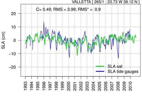
2.4c shows the case of Trieste where the two time series are highly correlated and the amplitude of local sea level is well reproduced by the altimetry. The same pattern has been found in the case of Dubrovnik (2.4d), except for the positive peaks of the tide gauge signals. In the central part of the basin, looking at the particular case of Valletta (Figure 2.4e), the two signals result as being highly correlated, underlining the fact that the sea-level signal captured by the tide-gauge station in Malta is an open-ocean signal.
The opposing situation has been found in the Levantine basin, where the shelves areas are generally narrow, and the correlation of the two signals tends to decrease up to 0.2, as it does along the Israeli coasts in the case of Hadera, where the altimetry signal range is much smaller than the tide-gauge one (Figure 2.4f). The continental shelf extension strongly influence the coastal ocean dynamics. The concept of narrow shelves has been reviewed by Sanchez-Arcilla & Simpson (2002) from both morphological (shelf width) and dynamical (along-slope cur-rent amplitudes) points of view. It is explained that regions constrained by two boundary layers (one in the near-shore and the other on the slope) that merge and control processes across the continental shelf can be defined as narrow shelves. In narrow-shelf areas the near-shore and slope processes couple these regions to the shelf dynamics, while in wide-shelf areas the three areas are dynamically sepa-rated. Assuming along-slope currents of 20-30 m s−1 over all the Mediterranean basin, Pinardi et al. (2005) define a shelf extension of 20-30 km as the critical shelf width for strong nonlinear coupling. Following their characterization of the shelves in the Mediterranean basin, critical shelf widths (20-30 km) can be found in the western part of the basin along the coasts of Morocco, Algeria and Libya; even less extended shelves (10-20 km) are observed along the Spanish coasts in the Alboran Sea and in the Balearic islands (Majorca). In the eastern part of the basin the most critical areas are represented by the Israeli and Cypriot coasts (< 10 km). On the other hand, the Adriatic Sea is the area, together with the Tunisian shelf, where the continental shelf is most extended in the basin (330 530
km).
Shelf extension cannot be the only parameter that affects the sea-level signals recorded by the two instruments, as it does not explain the differences found in areas where the continental shelf is well extended, such as Marseilles and Trieste, nor the differences found in narrow-shelf areas, such as in Valletta and Hadera. Investigation of other sources of local low-frequency sea-level variability will be the object of further studies about this topic, and will look in detail at the local ocean dynamics, focusing on Eddy Kinetic Energy (EKE; Pujol & Larnicol, 2005), heat and water fluxes that characterize the different coastal areas.
2. Comparison of in-situ and remote-sensing data SLA (cm) 1993 1994 1995 1996 1997 1998 1999 2000 2001 2002 2003 2004 2005 2006 2007 2008 2009 2010 −20 −10 0 10 20 C= 0.37; RMS = 4.94; RMS* = 0.99 SLA sat
SLA tide gauges
MALAGA [ 220/31 ; 12.33 W 45.43 N ] (a) Malaga SLA (cm) 1993 1994 1995 1996 1997 1998 1999 2000 2001 2002 2003 2004 2005 2006 2007 2008 2009 2010 −20 −10 0 10 20 C= 0.33; RMS = 3.93; RMS* = 0.97 SLA sat
SLA tide gauges
MARSEILLE [ 230/51 ; 30.62 W 36.83 N ]
(b) Marseille
Figure 2.4: SLA Time Evolution: tide-gauge and satellite altimetry comparison. From west to east across the basin; the cases of Mlaga (a), Ste (b), Marseilles (c), Dubrovnik (d), Valletta (e) and Hadera (f) are shown.
SLA (cm) 1993 1994 1995 1996 1997 1998 1999 2000 2001 2002 2003 2004 2005 2006 2007 2008 2009 2010 −20 −10 0 10 20 C= 0.49; RMS = 4.32; RMS* = 0.89 SLA sat
SLA tide gauges
TRIESTE [ 270/61 ; 2.63 W 39.55 N ] (c) Trieste SLA (cm) 1993 1994 1995 1996 1997 1998 1999 2000 2001 2002 2003 2004 2005 2006 2007 2008 2009 2010 −20 −10 0 10 20 C= 0.48; RMS = 4.06; RMS* = 0.88 SLA sat
SLA tide gauges
DUBROVNIK [ 280/81 ; 20.7 W 38.83 N ]
(d) Dubrovnik
Figure 2.4: SLA Time Evolution: tide gauge and satellite altimetry comparison. From west to east across the basin; the cases of Mlaga (a), Ste (b), Marseilles (c), Dubrovnik (d), Valletta (e) and Hadera are shown. (f).
2. Comparison of in-situ and remote-sensing data SLA (cm) 1993 1994 1995 1996 1997 1998 1999 2000 2001 2002 2003 2004 2005 2006 2007 2008 2009 2010 −20 −10 0 10 20 C= 0.49; RMS = 3.99; RMS* = 0.9 SLA sat
SLA tide gauges
VALLETTA [ 265/1 ; 23.73 W 39.12 N ] (e) Valletta SLA (cm) 1993 1994 1995 1996 1997 1998 1999 2000 2001 2002 2003 2004 2005 2006 2007 2008 2009 2010 −20 −10 0 10 20 C= 0.23; RMS = 4.52; RMS* = 1.03 SLA sat
SLA tide gauges
HADERA [ 320/16 ; 21.32 W 37.63 N ]
(f) Hadera
Figure 2.4: SLA Time Evolution: tide gauge and satellite altimetry comparison. From west to east across the basin; the cases of Mlaga (a), Ste (b), Marseilles (c), Dubrovnik (d), Valletta (e) and Hadera are shown. (f).
co de lon lat % C R M S RMS* tide.gauge satellite GIA ALEXANDR OUPOLIS 290/65 25.88 40.85 94 0.57 4.43 0.82 2.33 ± 1.38 2.58 ± 0.8 -0.44 ANT AL Y A II 310/52 30.62 36.83 78 0.43 4. 81 0.92 3.84 ± 1.53 0.18 ± 0.84 0.36 BAKAR 280/11 14.53 45.3 89 0.53 4.44 0.85 -0.37 ± 1.62 0.69 ± 0.8 0.71 BAR CELONA 220/61 2.17 41.35 80 0.28 4.46 1 7 ± 1.38 2.17 ± 0.68 -2.44 BODR UM II 310/46 27.42 37.03 79 0.22 5.28 0.99 2.59 ± 1.77 2.82 ± 0.51 -2.81 DUBR O VNIK 280/81 18.06 42.66 89 0.48 4.06 0.88 1.57 ± 1.4 0.58 ± 0.78 0.01 HADERA 320/16 34.88 32.47 78 0.23 4.52 1.03 2.06 ± 1.48 0.04 ± 0.64 0.08 KALAMAI 290/21 22.13 37.02 92 0.39 4.12 0.93 3.06 ± 1.08 0.54 ± 0.57 -KA T AK OLO N 290/17 21.32 37.63 92 0.07 4. 58 1.15 1.13 ± 1.05 0.82 ± 0.66 -0.28 KA V ALLA 290/61 24.42 40.92 85 0.26 9.96 0.96 -0.46 ± 2.93 1.81 ± 0.71 -0.26 KHALKIS NOR TH 290/34 23.6 38.47 92 0.36 4. 57 0.94 4.7 ± 1.19 1.09 ± 0.63 -0.03 KHALKIS SOUTH 290/33 23. 6 38.47 83 0.16 5.46 1.04 -1.92 ± 1.46 1.09 ± 0.63 -0.03 KHIOS 290/71 26.15 38.38 92 0.43 5.08 0.91 -0.5 ± 1.46 0.47 ± 0.79 -0.03 LER OS 290/91 26.88 37.08 90 0.42 4.15 0.91 -1.7 ± 1.24 0.57 ± 0.59 -0.66 LEVKAS 290/4 20.7 38.83 87 0.27 4.87 0.99 -0.55 ± 1.36 -0.39 ± 0.67 -MALA GA 220/31 -4.42 36.72 94 0.37 4.94 0.99 5. 7 ± 1.2 0.23 ± 0.94 -0.46 MALA GA II 220/32 -4. 42 36.72 93 0.39 4.3 1.04 2.57 ± 1.14 0.22 ± 0.94 -0.45 MARSEILLE 230/51 5.35 43.3 84 0.33 3.93 0.97 1.64 ± 1.16 0.92 ± 0.61 -0.4 MENTES/IZMIR 310/42 26.72 38.43 83 0.51 4.29 0.86 2.62 ± 1.5 1.15 ± 0.7 -0.43 NICE 230/81 7. 27 43.7 77 0.2 4.61 1.12 0.83 ± 1.26 -0.24 ± 0.78 -0.27 P A TRAI 290/14 21.73 38.23 75 0.03 6.13 1.04 10.47 ± 1.69 0.91 ± 0.5 -0.49 PREVEZA 290/1 20.77 38.95 84 0.17 4.86 1.08 -0.44 ± 1.18 -0.5 ± 0.69 -R O VINJ 280/6 13. 63 45.08 89 0.43 4.47 0.98 -0.84 ± 1.4 1.89 ± 0.95 -0.31
2. Comparison of in-situ and remote-sensing data SETE 230/21 3.7 43.4 72 0.16 8.83 0.99 2.58 ± 3.16 -0.2 ± 0.69 0.57 SPLIT -GRADSKA LUKA 280/31 16.44 43.51 89 0.55 4.12 0.84 2.37 ± 1.49 1.69 ± 0.85 -0.57 SPLIT R T MARJANA 280/21 16.39 43.51 88 0.59 4.46 0.81 -0.42 ± 1.73 1.67 ± 0.85 -0.55 THESSALONIKI 290/51 23.03 40.62 91 0.4 4.66 0.92 2.33 ± 1.26 0.22 ± 0.65 1.18 TOULON 230/61 5.92 43.12 95 0.35 3.82 0.97 -0.79 ± 1.04 -1.33 ± 0.63 1.56 TRIESTE 270/61 13.76 45.65 100 0.49 4. 32 0.89 1.05 ± 1.21 0.03 ± 0.82 1.49 V ALLETT A 265/1 14.52 35.9 87 0.49 3.99 0.9 -2.38 ± 1.36 -0.42 ± 0.79 0.42 ZAD AR 280/13 15.23 44.12 80 0.04 11.05 1.02 -1.59 ± 3.9 1.17 ± 0.75 0.19 T able 2.2: Satellite altimetry and tide gauges data comparison at the nearest p oin t: sla considered rem o ving the eta steric sat computed a s a the spatialm mean of the satellite data,remo ving the temp oral mean for the whole analysis p erio d (1993 -2010) and the in v erse barometer effect from the tide gauges time series. Columns 1 to columns 3 represen t the tide gauge stations metadata:n PSLMS co de and geographical co ordinates. Colum ns 4 express the p ercen tage of the time series completeness (%). Columns 5 to 7 sho w basic descriptiv e statistic of the data-sets comparison: correlation co efficien t (C), ro ot mean square error (RMS) and the ro ot mean square error normalized for standard deviation (RMS*). Columns 8 and 9 sho w the sea lev el trends estimated b y the tide gauges and satellite altimetry resp ectiv ely [mm y r − 1 ]. Col umn 9 is glacio-isosthatic adj ustmen t correction applied to the estimated trends.
2.5
Sea-level trend spatial variability
The trend (least square fitting) estimated from altimetry data shows a sea-level rise of 2.15 ± 0.7mm yr−1 (seasonal signal removed and GIA applied) on average in the Mediterranean area
during the period 1993 to 2010. This value, estimated over a relatively short temporal period, should be considered only as a general index of the sea-level ”rise” in the Mediterranean , and it does not have a continuous pattern in the basin. The significance of the trend found will be discussed in detail in the next section on trend temporal variability. Figure 2.5 shows the marked spatial variability of the sea-level trend in the Mediterranaean. It is interesting to notice how in the Adriatic and Aegean Seas high positive trends are found. More than 5 mm yr−1 are observed in the Adriatic Sea and up to 3 mm yr−1 along the Tunisian coast. These are the most extended shallow water areas in the basin (Pinardi et al., 2005), and are also more sensitive to the effects of the external forcings, such as heat and water fluxes, compared to deep ocean areas. In these areas the changes of the climatic variables have the strongest signature, which evidently results in high positive sea-level trends being resultant of the interaction of many of them.
Higher positive value are also observed in a large part of the Eastern basin, locally underlining the presence of recurent gyres and eddies in the circulation. Maximun positive peaks, with more than 8 mm yr−1, have been found in the Levantine basin, south-eat of Crete (Ierapetra gyre) and west of Crete (Pelops gyre) (Pinardi et al., 2005). Similar peaks are indicated at the location of the Mersa Matruh gyre. On the other hand, a strong negative trend (less than -8 mm yr−1) is observed in the Ionian Sea as a consequence of an important change in the circulation observed in this basin since the beginning of the nineteen-nineties (Demirov & Pinardi, 2002).
2. Comparison of in-situ and remote-sensing data −10 −8 −6 −4 −2 0 2 4 6 8 10 mm/y 0 10 20 30 30 35 40 45
SLA Trend in the Mediterranean Sea 1993 − 2010 field reconstructed using 20 leading EOFs
Lon
Lat
Figure 2.5: Satellite altimetry trend [mm yr−1] spatial variability in the Mediter-ranean during the period 1993-2010. Steric signal removed, glacial-isostatic ad-justment (GIA) applied.
2.6
Sea-level trend temporal variability
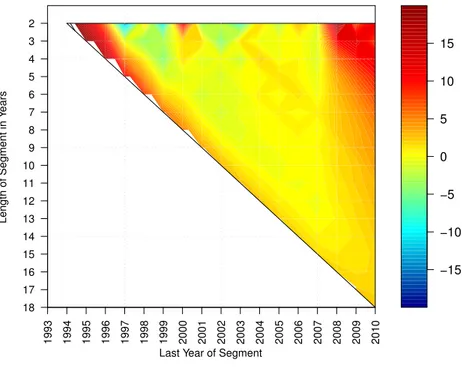
The sea-level trend in the Mediterranean also shows a high temporal variabil-ity. Adopting the method described in Liebmann et al. (2010) to estimate the global surface temperature trends, in Figure 2.6a every possible trend (mm yr−1) computed as a function of the length of the period considered (1-year changes discarded) is shown. Each point of the diagram indicates sea-level trend up to a specific year (x-axis) obtained considering the number of years expressed on the y-axis. In this way it is possible to note all the sea-level changes occuring over the last 18 years (1993-2010). One of the most interesting results of this analysis is that during the period between 1998 and 2010 it is almost impossible to rec-ognize any trend without considering at least 10 years of data, as confirmed by the T-test trend significance analysis (Figure 2.6b). This analysis also underlines the fact that to find a stable and significative positive trend in the Mediterranean basin it is necessary to consider at least 14 years of data, from 1993 to 2007, and more then 15 years to obtain a high significant trend. Sea-level change occurring
over a short time period does not result as significant, and does not account for the signal of the low-frequency sea-level variability and trend. These results, also confirmed performing bootstrap analysis (Liebmann et al., 2010), also show that the period considered to obtain the trend spatial varibility, even when obtianed starting from only 17 years of data, allow a trend significance level of 99.9 % to be obtained.
2. Comparison of in-situ and remote-sensing data −15 −10 −5 0 5 10 15 mm/y 1993 1994 1995 1996 1997 1998 1999 2000 2001 2002 2003 2004 2005 2006 2007 2008 2009 2010 18 17 16 15 14 13 12 11 10 9 8 7 6 5 4 3 2
SLA Trend as function of length of segment and ending year of calculation
Last Year of Segment
Length of Segment in Y
ears
(a) SLA Trend as function of length of segment and ending year of calcu-lation (mm yr−1). 80.0 85.0 90.0 95.0 97.5 99.9 % 1993 1994 1995 1996 1997 1998 1999 2000 2001 2002 2003 2004 2005 2006 2007 2008 2009 2010 18 17 16 15 14 13 12 11 10 9 8 7 6 5 4 3 2
Rank of observed changes using t−test
Last Year of Segment
Length of Segment in Y
ears
(b) Rank of observed changes using T - test (%).
Figure 2.6: Satellite Trend as function of the length of the period considered. Panel (a) shows all the possible trends ending at the year indicated in the x-axis, obatained considering the number of years shown over the y-axis. Thus, considering the point x=2000 and y=10, it express the sea-level trend value up to the year 2000, obtained considering 10 years of data. Panel (b) shows the trend significance obtained performing a T-test; values below 80 % are not shown.
2.7
Summary
A method to decompose the sea-level signal of in-situ and remote-sensing obser-vations is proposed in order to compare tide-gauge and altimetry sea-level low-frequency variability. An interesting result is that the tide-gauge coastal sea-level signal is a large-scale signal and results as being well comparable with satellite altimetry data in the basin areas where the continental shelf is extended. In particular, the two signals result as being well correlated in the Adriatic and off Malta; the latter represents a particular case of an open-ocean island tide-gauge that captures a sea-level signal similar to the satellite altimetry in the area. Mov-ing towards the Levantin basin, the shelf extension generally decreases, and the two datasets tend to be less comparable in terms of correlation, although it re-mains positive with a root mean square error that rere-mains under 5 cm (Hadera). Shelf extension does not explain the differences found in areas where the con-tinental shelf is well extended, such as Marseilles and Trieste, nor the differences found in narrow-shelf areas, such as in Valletta and Hadera. Local low-frequency sea-level variability will be the object of further studies, and will look in detail at specific ocean dynamics (i.e., Eddy Kinetic Energy, heat and water fluxes) at the local scale.
Looking at the basin trend, a positive trend of 2.15 ± 0.7mm yr−1 is observed in the Mediterranean basin between 1993 and 2010. The basin trend presents a marked spatial variability, mainly characterized by strong positive trends in the shelf areas and negative trends in the Ionian, due to a strong change of the circulation in this basin. The study on the trend variations as function of the number of years considered shows that in ordert to obtain a significant and stable positive trend during the period between 1993 and 2010 at least 15 years of data should be considered.
One of the points of weakness of this study is the total lack of in-situ data in the southern part of the basin. This is an issue that affects every study about sea level in the Mediterranean, and has been faced several times during this research.
Chapter 3
Sea-level variability over a
centennial time period
3.1
Sea-level studies over a centennial time scale
Changes in sea-level are one of the most important indexes of climate change, as they are caused by many processes that act at different spatial and temporal scales. One of the biggest sources of uncertainty related to sea-level change is that we still do not know what the sea-level response to climate change scenarios is (Church et al., 2010). (Bindoff et al., 2007) aims at providing the changes over the coming century, which are affected by great uncertainties. The best possible strategy to minimize this future uncertainty is to look at the past and try to understand in details all sea-level variability components.
In this context, all observational instruments, such as altimetry and tide gauges, provide very important information for understanding sea-level change dynamics. Tide-gauge data have very long time series that can provide useful information over decadal time scales, but are spatially discontinuous. Satellite altimetry, on the other hand, is almost homogeneous in the spatial domain, but the data only spans the past 20 years.
Sea-level reconstruction is a method capable of merging the altimetry and tide-gauge sea-level signals, taking spatial information from the former and temporal amplitude from the latter (Kaplan et al., 2000). Over the last ten years, many
efforts have been made to realize various sea-level reconstructions at both global (Church, 2006; Church et al., 2004a; Church & White, 2011) and regional scales. The first sea-level reconstruction for the Mediterranean, was realized by (Calafat & Gomis, 2009) using satellite altimetry data with a horizontal resolution of 1/4 ◦ and tide gauges for the period 1945-2004, later updated up to 2008 using 1/8 ◦ x 1/8 ◦ satellite data in Calafat & Jord`a (2011), looking in particular at errors associated with seal-level reconstructions. Meyssignac et al. (2011) offers a comparison between satellite-based and model-based reconstructions obtained using outputs from numerical models for the period 1976-2000.
The general objective of this work is to attempt a sea-level reconstruction in the Mediterranean over a centennial time scale (from the end of the nineteenth century to 2010). To achieve this objective, satellite altimetry and tide-gauge data have been merged through a reduced-space optimal interpolation technique as described in Church et al. (2004a). This method allows sea-level spatial varibil-ity acquired from the altimetry leading EOFs to be fitted to temporal variabilvaribil-ity from tide-gauges. The specific objectives are: i) to validate results obtained at the basin scale with satellite altimetry data, for the satellite era, as well as locally with tide-gauge time series over the remaining reconstruction period; ii) to inves-tigate sea-level trend spatial and temporal variability over the last century, paying particular attention to low-frequency variability (decadal and multidecadal).
This chapter in organized as follows: a description of the method used to perform the sea-level reconstruction is given in Section 3.3. Section 3.2 shows the satellite altimetry data and tide-gauge stations used for the reconstruction.
Section 3.5 shows the validation of the sea-level reconstruction with a com-parison with the altimetry data for the period 1993-2010, as well as a comcom-parison with tide-gauge observations during reconstruction sub-periods. In the second part of the section, the results obtained for the entire reconstruction period are discussed, with particular attention paid to trend variations at the decadal time scales. Section 3.6 illustrates a case study of the Tunisian coasts, where sea-level reconstruction data has been used to look at long-term sea level trends in target sensitive areas. All the results obtained are summarized in Section 3.7.
3. Data processing
3.2
Data processing
Here we illustrate the data processingof the satellite altimetry and tide-gauge datasets
in order to prepare the data for sea-level reconstruction.Tide-gauge and al-timetry data have been corrected as described in the previous chapter (section 2.3) in order to obtain from both datasets physically coherent sea-level signals.
3.2.1
The tide-gauge dataset
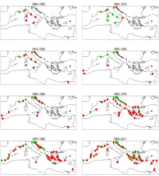
The RLR dataset distributed by the PSMSL (Woodworth & Player, 2003) is composed, in the Mediterranean basin, of 93 stations, with records that start in 1872. RLR datasets reduce tide-gauge time series to a common datum (see Section 2.2) using a tide-gauge history datum provided by the supplying authority (see Table 2.2, last column). Time series length depends on the station considered: 4 stations in the Mediterranean basin have a range longer than 100 years, as shown in Table 3.1. The distribution and temporal coverage of the entire dataset are shown in Appendix A. The reconstruction period has been divided into differents sub-periods according to in-situ data availability. The gaps in the dataset have been filled with spline interpolation for gaps up to 6 months, and multiple linear regressions (Calafat & Jord`a, 2011) for gaps up to 12 months, while tide-gauge stations with gaps longer than 12 months during each specific sub-period have been filtered out of the reconstruction. These periods have an overlapping period of 12 months, which is a necessary condition for integrating EOF amplitudes change backwards in time (Church et al., 2004b). The total reconstruction period is from 1885 to 2010, divided into 8 sub-periods spanning 15 years each. The tide-gauge stations considered for each sub-period are shown in Figure 3.1.
Figure 3.1: Tide-gauge stations positions. In each panel the number and positions of tide-gauge stations used in the specific reconstruction period are shown. Red dots represent the total number of stations available in the specific temporal periods indicated above. Green dots indicate the actual amount of tide-gauge stations considered, representing the stations with the most complete time series.
3. Data processing
code lon lat range years n.years % ref
TRIESTE 270/61 13.76 45.65 1905-2010 106 100 94 -9.4 GENOVA 250/11 8.9 44.4 1884-1997 114 90 78 -10.2 MARSEILLE 230/51 5.35 43.3 1885-2010 126 122 97 -8.5 VENEZIA 1 270/54 12.33 45.43 1909-2000 92 87 94 -6.8 VENEZIA 2 270/51 12.33 45.42 1872-1920 49 48 98 -9.9 VENEZIA 3 270/41 12.35 45.42 1889-1913 25 24 96 -10.5
Table 3.1: Tide gauge stations RLR in the Mediterranean Sea, with time series that span a period longer 100 years. Columns 4 ad 5 express the period and the number of years covered by the station data. Columns 6 and 7 show the amout of data available once rmoved the missing data as numbers of yeasr and percentage (%) respectively. Column 8 indicates tide-gauges benchmarks [m] (see Appendix 1). We consider also the three tide gauges stations located in Venezia that considered togheter cover a period longer that 100 years. In Column 1, VENEZIA 1 correspond to Venezia Punta della Salute, VENEZIA 2 is Venezia Santo Stefano and VENEZIA 3 represent Venezia Arsenale.
3.2.2
Satellite Altimetry dataset
The satellite altimetry data (Pujol & Larnicol, 2005) corrected as described in Chapter 2 has been used here to retrieve the sea-level reconstruction spatial vari-ability. Data have been selected for the period from January 1993 to December 2010 as monthly means. The data have been pre-processed removing the seasonal cycle and subtracting the mean sea-level trend (see Chapter 3), in order to obtain unbiased EOFs (Kaplan et al., 1997). Since EOFs account only for the spatial variability, the reconstructed sea-level trend (if present) will be obtained from the tide-gauge records temporal variability. Following (Meyssignac et al., 2011), GIA correction provided by Stocchi & Spada (2009), which is of the order of -0.25 mmyr−1, has been applied to the data.
3.3
Merging remote-sensing and in-situ sea-level
signals: statistical reconstruction method
The method used to reconstruct the sea-level field during the last century is a reduced-space optimal interpolation described by Kaplan et al. (2000), applied as in Church et al. (2004a) and Calafat & Gomis (2009) for global and regional sea-level reconstructions respectively.
The first step, called feature extraction, is to get spatial information from the satellite data that will provide the reconstruction spatial variability. Organizing the altimetry data in a matrix that contain in the rows (m) the spatial grid points, and in the columns (n), all the time steps, an m x n matrix (Z ) is obtained. The matrix Z can be separated into three matrices by using a singular value decomposition (SVD) :
Z = U LVT (3.1)
where U is an m x n matrix that contain the left singular vectors of the matrix Z (eigenvectors of the covariance matix ZTZ, EOFs), L is an n x n diagonal
matrix that contains the singular values (γ, square root of the eigenvalues of the covariance matrix) of Z, and V is an n x n matrix the columns of which are the right singular vectors of Z (eigenvectors of the covariance matix ZZT)(Bjornsson & Venegas, 1997). Eigenvalues are related to the singular values by λi = s2i/n,
where n is the number of grid points (Storch & Zwiers, 1999). Each eigenvalue gives a fraction of the total variance in the covariance matrix explained by each mode. The variance (Y ) explained by each EOFi is therefore obtained dividing
the relative eigenvalue (λi) by the sum of all the other eigenvalues (Bjornsson &
Venegas, 1997): Yi = λi/ n X i=1 λi (3.2)
The expression (3.1) can also be written as :

![Figure 2.3: η st sat (t) of satellite altimetry (green line) and steric signal obtained subtracting the satellite gravimetry (GRACE) signal (black line) from the satellite altimetry signal; y-axis values expressed as [cm].](https://thumb-eu.123doks.com/thumbv2/123dokorg/8193031.127670/30.892.189.761.549.816/satellite-altimetry-subtracting-satellite-gravimetry-satellite-altimetry-expressed.webp)


![Figure 2.5: Satellite altimetry trend [mm yr −1 ] spatial variability in the Mediter- Mediter-ranean during the period 1993-2010](https://thumb-eu.123doks.com/thumbv2/123dokorg/8193031.127670/41.892.156.778.210.539/figure-satellite-altimetry-spatial-variability-mediter-mediter-ranean.webp)
![Figure 3.2: Optimal EOFs number selection. The x-axis is the number of EOFs considered; the y-axis indicates the rmse [cm] obtained comparing altimetry and reconstructions over the training period (2002 - 2010; blue line)](https://thumb-eu.123doks.com/thumbv2/123dokorg/8193031.127670/54.892.237.721.584.829/selection-considered-indicates-obtained-comparing-altimetry-reconstructions-training.webp)

