A
A
l
l
m
m
a
a
M
M
a
a
t
t
e
e
r
r
S
S
t
t
u
u
d
d
i
i
o
o
r
r
u
u
m
m
–
–
U
U
n
n
i
i
v
v
e
e
r
r
s
s
i
i
t
t
à
à
d
d
i
i
B
B
o
o
l
l
o
o
g
g
n
n
a
a
D
D
O
O
T
T
T
T
O
O
R
R
A
A
T
T
O
O
D
D
I
I
R
R
I
I
C
C
E
E
R
R
C
C
A
A
I
I
N
N
S
S
C
C
I
I
E
E
N
N
Z
Z
E
E
D
D
E
E
L
L
L
L
A
A
T
T
E
E
R
R
R
R
A
A
C
C
i
i
c
c
l
l
o
o
X
X
X
X
V
V
I
I
I
I
S
S
e
e
t
t
t
t
o
o
r
r
e
e
C
C
o
o
n
n
c
c
o
o
r
r
s
s
u
u
a
a
l
l
e
e
d
d
i
i
a
a
f
f
f
f
e
e
r
r
e
e
n
n
z
z
a
a
:
:
0
0
4
4
/
/
A
A
2
2
S
S
e
e
t
t
t
t
o
o
r
r
e
e
S
S
c
c
i
i
e
e
n
n
t
t
i
i
f
f
i
i
c
c
o
o
d
d
i
i
s
s
c
c
i
i
p
p
l
l
i
i
n
n
a
a
r
r
e
e
:
:
G
G
E
E
O
O
/
/
0
0
2
2
Low-temperature thermochronological
evolution of the Menderes and Alanya massifs
(Turkey)
P
P
r
r
e
e
s
s
e
e
n
n
t
t
a
a
t
t
a
a
d
d
a
a
:
:
D
D
o
o
t
t
t
t
.
.
F
F
r
r
a
a
n
n
c
c
e
e
s
s
c
c
o
o
M
M
i
i
t
t
t
t
i
i
g
g
a
a
C
C
o
o
o
o
r
r
d
d
i
i
n
n
a
a
t
t
o
o
r
r
e
e
D
D
o
o
t
t
t
t
o
o
r
r
a
a
t
t
o
o
P
P
r
r
o
o
f
f
.
.
J
J
o
o
D
D
e
e
W
W
a
a
e
e
l
l
e
e
P
P
r
r
o
o
f
f
.
.
W
W
i
i
l
l
l
l
i
i
a
a
m
m
R
R
C
C
e
e
a
a
l
l
v
v
a
a
a
a
t
t
o
z
o
z
z
z
r
r
a
e
a
e
C
C
o
o
-
-
r
r
e
e
l
l
a
a
t
t
o
o
r
r
i
i
P
P
r
r
o
o
f
f
.
.
M
M
a
a
s
s
s
s
i
i
m
m
i
i
l
l
i
i
a
a
n
n
o
o
Z
Z
a
a
t
t
t
t
i
i
n
n
(
(
U
U
n
n
i
i
v
v
e
e
r
r
i
i
s
s
i
i
t
t
à
à
d
d
i
i
P
P
a
a
d
d
o
o
v
v
a
a
)
)
P
P
r
r
o
o
f
f
.
.
A
A
r
r
a
a
l
l
I
I
.
.
O
O
k
k
a
a
y
y
(
(
İ
İ
s
s
t
t
a
a
n
n
b
b
u
u
l
l
T
T
e
e
k
k
n
n
ı
ı
k
k
Ü
Ü
n
n
ı
ı
v
v
e
e
r
r
s
s
ı
ı
t
t
e
e
s
s
ı
ı
)
)
E
E
s
s
a
a
m
m
e
e
f
f
i
i
n
n
a
a
l
l
e
e
a
a
n
n
n
n
o
o
2
2
0
0
1
1
5
5
3
Wind in the east, mist coming in.
Like something is brewing, about to begin.
Can’t put my finger on what lies in store
But I hope what’s to happen, never happened before!
5
ACKNOWLEDGMENTS
Many people have contributed to the realization of this work. First of all, I would like to express my gratitude to my advisor Prof. William Cavazza for the helpful support of my PhD study and research. His guidance during all the time of research and writing, his constant motivations and discussions made me a more complete scientist. Without him this thesis would never be possible. Prof. Massimiliano Zattin taught me AFT counting and analysis and I am very grateful for his detailed comments and the support during the drawing up of this thesis. Prof. Aral Okay was a perfect mentor both during the collection of the samples and for the writing of this thesis. I also want to thank Dr. Claudio Dal Monte who advised me in the sample processing. Thanks to Prof. Marco Malusà from the University of Milan – Bicocca, for his useful comments on an earlier version of this dissertation. Special thanks to Dr. Maria Giuditta Fellin who taught me how to perform AHe and ZHe: her kindness and competence were a light during the darkest moments of this work (and not only). During my Ph.D. I make acquaintance, between Bologna and Padua, of several special fellows –including (in strictly alphabetical order) Benedetta, Davide, Francesco, Irene, Veronica– and I want to thank you all for your hospitality and friendship. A special mention goes to my Ph.D. research partner Irene Albino: we shared travels, suffering, soups for breakfast, nights in the lab and other strange stuffs; thanks for all the support and the funniest moments.
Thanks to my Neapolitan brothers Antonio, Claudio and Giorgio: you know why. Last but not least: my family! Deepest thanks for every time you believed in me and in my abilities, and for support every time i needed!
Thank you all, I have learned a lot from you and I will never forget you, even those who have lost during this wonderful journey!
7
Ringraziamenti
Molte persone hanno contribuito alla realizzazione di questo lavoro. Prima di tutto vorrei esprimere la mia gratitudine al mio relatore Prof. William Cavazza per il suo utile sostegno nel corso del percorso del mio dottorato. La sua guida durante sia il periodo di ricerca sia della stesura della tesi, la sua motivazione costante e le discussioni mi hanno reso uno scienziato più completo. Senza di lui questo lavoro non sarebbe stato possibile. Il Prof. Massimiliano Zattin mi ha insegnato la metodologia delle AFT ed io gli sono davvero grato per i commenti dettagliati e per il supporto durante la correzione di questa tesi. Il Prof. Aral Okay è stato una guida perfetta sia durante le campagne di campionamento in Turchia sia durante le fasi di stesura di questa tesi. Voglio inoltre ringraziare il Dott. Claudio Dal Monte che mi ha guidato nell’apprendimento delle procedure della preparazione dei campioni. Grazie al Prof. Marco Malusà dell’Università di Milano – Bicocca, che ha revisionato una versione preliminare di questo lavoro. Un ringraziamento speciale va alla Dott.ssa Maria Giuditta Fellin che mi insegnato come effettuare analisi AHe e ZHe: la sua gentilezza e competenza sono state una luce durante i momenti più bui di questo lavoro (e non solo).
Durante il mio dottorato ho conosciuto, tra Bologna e Padova, tanti compagni speciali – tra cui (in rigoroso ordine alfabetico) Benedetta, Davide, Francesco, Irene, Veronica- e perciò vorrei ringraziarvi tutti per la vostra ospitalità e per l’amicizia. Un ringraziamento speciale va alla mia compagna di squadra di ricerca Irene Albino: abbiamo condiviso viaggi, sofferenze, zuppe per colazione, nottate in laboratorio e altre cose strane; grazie per tutto l’aiuto e per tutti i momenti divertenti.
Grazie ai miei fratelli napoletani Antonio, Claudio e Giorgio: voi sapete per cosa. Ultima ma non meno importanti: la mia famiglia! I miei più sentiti ringraziamenti per ogni volta che avete creduto in me e nelle mie capacità e per il supporto ogni volta che ne avevo bisogno.
Grazie a tutti, ho imparato molto da ciascuno di voi e non vi dimenticherò mai, soprattutto anche coloro ho perso nel corso di questo viaggio meraviglioso!
9
TABLE OF CONTENTS
ABSTRACT ...13
RIASSUNTO ...15
Chapter I - INTRODUCTION...17
Chapter II - GEOLOGICAL SETTING AND EVOLUTIONARY MODELS ...15
2.1 The Rhodope Massif ...16
2.2 The Vardar Zone ...18
2.3 The Pontides ...19
2.3.1 The Strandja Massif ...21
2.3.2 The İstanbul Terrane ...25
2.3.3 The Sakarya Terrane ...26
2.4 The Cyclades ...27
2.5 Anatolide-Tauride Domain ...29
2.5.1 Bornova Flysch Zone ...30
2.5.2 The Tavşanlı Zone ...31
2.5.3 The Afyon Zone ...32
2.5.4 Central Anatolian Crystalline Complex ...32
2.5.5 The Menderes Massif ...34
2.5.5.1 General description and definition of the Menderes Nappes ...34
2.5.5.2 Tectonostratigraphic description ...40
2.5.5.3 Metamorphic evolution of the Menderes Massif ...43
2.5.6 The Lycian Nappes...45
2.5.6.1 General stratigraphy ...46
2.5.6.2 Origins ...46
2.5.7 Sedimentary basins of the southern Menderes Massif ...48
2.5.7.1 The Ören and Yatağan basins ...50
2.5.7.2 The Kale-Tavas basin ...50
2.5.7.3 The Denizli Molasse ...51
2.5.8 The Taurides ...52
10
2.5.9.1 Alanya metamorphic nappes ...56
2.5.9.2 Geochronology ...57
2.5.9.3 Alanya tectonic window ...58
2.6 Arabian Platform ...59
2.7 Cyprus ...59
2.7.1 The Kyrenia Range...60
2.7.2 The Troodos complex ...63
2.7.3 The Mamonia Complex ...66
2.8 Geodynamic Evolution Of The Aegean-Anatolian Region ...67
2.8.1 The Hellenic orogen ...68
2.8.2 Extrusion of Anatolia ...73
2.8.3 Aegean extension ...74
2.8.4 From the Hellenic orogen to the Aegean sea ...75
2.9 Relationship Between Southern Anatolia And Cyprus ...77
Chapter III - SAMPLING ...79
Chapter IV - METHODS ...85
4.1 Principles of thermochronometry ...86
4.2 Fission track themochronometry ...90
4.2.1 Formation of fission tracks ...91
4.2.2 Analytical procedures and grain age calculation ...92
4.2.3 Retention and annealing of FT ...94
4.2.4 Data analysis and interpretation ...96
4.3 Helium thermochronometry ...98
4.3.1 He ingrowth ...98
4.3.2 Analytical procedures ...99
4.3.3 α – ejection correction ... 100
4.3.4 Diffusion behaviour ... 101
4.3.5 The effect of slow cooling ... 103
4.3.6 Data analysis and interpretation ... 103
4.4 Sample preparation procedures ... 104
4.5 Analytical facilities and procedures ... 106
11
4.5.2 AHe and ZHe analysis ... 107
4.6 From thermochronometric ages to erosion rates ... 108
Chapter V - ANALYTICAL RESULTS ... 112
5.1 AFT results ... 113 5.2 Thermal modeling ... 116 5.3 AHe results ... 121 5.4 Erosional rate... 123 5.4 ZHe results ... 130 Chapter VI - DISCUSSION ... 133
6.1 General features of metamorphic core complexes ... 134
6.2 Menderes Massif evolution ... 137
6.3 Alanya Massif evolution... 150
6.4 Cyprus results ... 153
6.5 Thermochronologic results and overall paleotectonic evolution of the study area ... 156 6.5.1 Late Cretaceous ... 156 6.5.2 Eocene ... 160 6.5.3 Early Oligocene ... 162 6.4.4 Early Miocene ... 164 6.4.4 Late Miocene ... 166
Chapter VII - CONCLUSIONS ... 168
13
ABSTRACT
In this dissertation, the application of two low-temperature thermochronometers [fission-track analysis and (U-Th)/He analyses, both on apatite] to various tectonostratigraphic units of the Menderes and Alanya Massifs of Turkey has provided significant new constraints to the understanding of their structural evolution. Such constraints can be applied to more general interpretative models of post-collisional extensional processes in the eastern Mediterranean and elsewhere.
The Menderes Massif of western Anatolia is one of the largest metamorphic core complexes on Earth. Recent research on the Menderes is providing compelling results on the post-collisional tectonic evolution of the Aegean and peri-Aegean domain. The integration of the geochronometric dataset presented in this dissertation with preexisting ones from the literature delineates three groups of samples within the Menderes Massif. Such groups are chronologically and geographically defined: (i) samples from the northern and southern sectors of the massif –i.e. respectively north and south of the Gediz and Buyük Menderes detachment faults- yielded apatite fission-track ages ranging between the Late Oligocene and the Early Miocene, whereas (ii) samples from the central sector are younger, with most ages falling within the Middle-Late Miocene. The results of this study are consistent with the interpretation for a symmetric exhumation of the Menderes Massif.
The Alanya Massif of SW Anatolia has been interpreted as the southern margin of an ‘Alanya ocean’ originally located to the south of the Tauride carbonate platform. Northward subduction of this ocean led to Late Cretaceous thrusting and HP/LT metamorphism, followed by exhumation. Collision-related, northward backthrusting during the Paleocene-Early Eocene –likely resulting from the final closure of the İzmir–Ankara–Erzincan ocean to the north- created the present stacking order, thus implying that most exhumation had ended by Late Eocene time. Apatite fission-track ages from this study range from 31.8 to 26.8 Ma (Late Rupelian – Early Chattian) and point to a previously unrecognized mid-Oligocene cooling/exhumation episode, thus challenging the commonly held notion that the Alanya Massif did not suffer significant tectonic events after Eocene northward backthrusting. At this early stage in the structural understanding of the Alanya
14
Massif and the surrounding regions it is not possible to define whether the Oligocene cooling episode developed in an overall stress regime of syn-collisional compression or post-collisional extension. For the time being, we tentatively favour the interpretation of the mid-Oligocene fission-track ages from the Alanya Massif as the record of the structural inversion of the Alanya nappe stack, tectonic denudation, and cooling. This is in view of the overall transition from a compressional (Eocene) to an extensional (?Oligocene-Miocene) regime recognizable over the entire Aegean and peri-Aegean regions.
(U-Th)/He analysis on zircon crystals obtained from Late Cretaceous trondhjemites of the Troodos Massif igneous succession of Cyprus show that they cooled from emplacement temperature to 180° C in a relatively short time span, ranging approximately between 20 and 27 My. Such cooling could be either (i) an effect of the normal magmatic cooling of the plagiogranites or (ii) a result of exhumation. ZHe results from the Late Triassic turbiditic sandstones of the Vlambouros Formation indicate that the Mamonia mélange of southern Cyprus was never buried enough to reach the closure temperature of the ZHe radiometric system (ca. 200°C), thus retaining the Paleozoic signature of a previous sedimentary cycle.
15
RIASSUNTO
L’applicazione di due metodi termocronologici delle basse temperature (analisi delle tracce di fissione e datazioni (U-Th)/He, entrambe su apatite) alle unità tettonostratigrafiche dei massicci del Menderes e di Alanya in Turchia meridionale ha permesso di ottenere nuovi risultati che vincolano meglio la loro evoluzione strutturale. Tali risultati possono essere applicati ai modelli interpretativi che ricostruiscono i processi di estensione post-orogenica che hanno interessato l’intera regione mediterranea ed altre aree simili.
Il Massiccio del Menderes, in Anatolia occidentale, è uno dei più grandi metamorphic core complex del pianeta. Lavori recenti hanno fornito risultati interessanti sull’evoluzione post-orogenica della regione egea e peri-egea. L’integrazione dei dati geocronologici ottenuti in questo lavoro con quelli presenti in bibliografia ha permesso di costituire un dataset che copre l’intero massiccio. I dati termocronologici sono suddivisibili in tre gruppi definiti cronologicamente e geograficamente: (i) i campioni provenienti dai settori settentrionali e meridionali del massiccio -rispettivamente a nord e a sud delle faglie a basso angolo di Gediz e Büyük Menderes- presentano delle età, ottenute mediante le tracce di fissione su apatite, che variano tra l’Oligocene superiore e il Miocene inferiore; (ii) i campioni provenienti dal settore centrale del massiccio hanno restituito delle età più recenti, concentrate perlopiù tra il Miocene medio e superiore. I risultati di questo lavoro confermano l’interpretazione di un’esumazione simmetrica per il Massiccio del Menderes.
Il Massiccio di Alanya, in Anatolia sudoccidentale, è stato da sempre interpretato come il margine meridionale del cosiddetto oceano di Alanya, un braccio di mare originariamente collocato a sud della piattaforma carbonatica dei Tauri. La subduzione verso nord di questo oceano, legata alla prima fase dell’orogenesi alpina, ebbe come conseguenza la strutturazione di una pila di falde nel Cretaceo superiore e l’instaurarsi di un regime metamorfico di alta pressione/bassa temperatura. Tali falde furono poi carreggiate verso nord in backthrusting durante una successiva fase compressiva avvenuta tra il Paleocene e l’Eocene inferiore. Tale fase tettonica determinò l’attuale geometria strutturale delle unità affioranti e fu verosimilmente l’effetto finale della collisione continentale lungo
16
la linea di sutura di İzmir-Ankara-Erzincan. Questa successione di eventi implicherebbe che l’esumazione sarebbe perlopiù terminata entro l’Eocene superiore. Viceversa le età ricavate dalle tracce di fissione su apatite in questo studio variano tra 31.8 e 26.8 Ma (Rupeliano superiore – Cattiano inferiore) e indicano perciò per la prima volta un episodio di raffreddamento/esumazione nell’Oligocene medio. Il livello delle conoscenze strutturali nel Massiccio di Alanya non è tale da poter definire se tale episodio si sviluppò in un contesto compressivo sin-collisionale o estensionale post-sin-collisionale. Per il momento ipotizziamo preliminarmente che le età oligoceniche di raffreddamento/esumazione ottenute durante questo lavoro di tesi mediante l’analisi delle tracce di fissione su apatite indichino l’inversione strutturale, il denudamento tettonico e il conseguente raffreddamento delle falde del Massiccio di Alanya durante la transizione dal regime compressivo collisionale a quello estensionale post-collisionale nei Tauri centrali, per analogia con l’evoluzione generale del vicino dominio egeo e peri-egeo.
Le analisi (U-Th)/He sugli zirconi ottenuti dai plagiograniti tardo-cretacei della successione magmatica del Massiccio di Troodos a Cipro indicano che tali rocce si raffreddarono dalla temperatura di messa in posto a 180° C in un intervallo di tempo relativamente breve (27-20 Ma). Tale raffreddamento potrebbe essere il risultato del normale raffreddamento magmatico oppure derivare da processi esumativi. Analoghe analisi sulla Formazione di Vlambouros (Triassico superiore) indicano che, durante la sua tormentata evoluzione tettonico - strutturale, il mélange di Mamonia nella parte meridionale di Cipro non é mai stato sepolto abbastanza profondamente da raggiungere temperature superiori ai 200°C, la temperatura di chiusura del sistema radiometrico (U-Th)/He su zircone. Le torbiditi di Vlambouros hanno quindi conservato la firma isotopica relativa ad un precedente ciclo sedimentario del Paleozoico medio - superiore.
17
Chapter I
INTRODUCTION
10
Over the last forty years metamorphic core complexes –in both oceanic and continental settings- have attracted much attention because they record fundamental thermomechanical processes in extending lithosphere (see Whitney et
al., 2013, for a review). Metamorphic core complexes in continental settings
commonly occur in orogenic belts and offer important opportunities to examine exposures of middle-to-lower continental crust in regions that have undergone large-scale post-orogenic extension.
The Menderes Massif of western Anatolia is one of the largest metamorphic
core complexes on Earth. Despite much research progress in the past ten years,
there are still substantial unresolved issues regarding the tectonic and metamorphic history of the Menderes Massif.
Fig. 1.1 - The Menderes Massif of western Anatolia is a portion of a large extensional province comprising the Aegean and peri-Aegean regions. Extension followed crustal thickening in the Paleogene, a result of the closure of the northern branch of the Neotethys and the ensuing continental collision. Extension began in the Oligocene in the Rhodopes and shifted progressively to the south (Kazdağ, Menderes, Cyclades) mirroring the southward slab rollback of the Aegean subduction zone (drawing courtesy of A. I. Okay).
11
The pre-Miocene tectonics of the Menderes Massif has been interpreted in terms of (i) a large-scale recumbent fold (Okay, 2001; Gessner et al., 2002), (ii) a series of nappes stacked during south-directed thrusting (Ring et al., 1999a; Gessner et al., 2001b), and (iii) a series of north-directed thrusts that subsequently collapsed either in a bivergent fashion (Hetzel et al., 1998) or through top-to-south extension (Bozkurt & Park, 1994; Bozkurt, 2007). The key controversies are focused on which structures are related to the kinematics of early Tertiary Alpine crustal shortening, which ones are related to late Tertiary crustal extension, and how this fits with the observed large-scale architecture of the massif.
This study is aimed at reconstructing the thermal history of the Menderes, in order to provide new constraints on the debated Paleogene-Neogene evolution of the western Anatolian region. This is achieved through the application of low-temperature thermochronometers such as apatite fission-track and (U-Th)/He on
apatite on areas of the massif which previously had been studied only marginally.
The obtained new geochronological data will be compared to the results available in the literature (e.g. Buscher et al., 2013; Gessner et al., 2001a; 2013; Ring et al., 2003; Thomson & Ring, 2006) to better constrain the evolution of the massif.
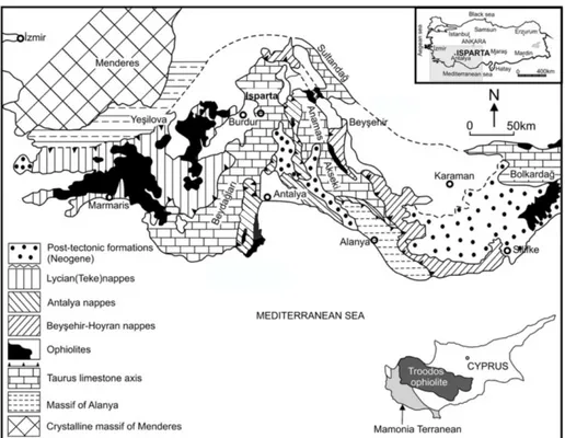
The same analytical approach was employed for the thermochronometric study of another major metamorphic salient of western Anatolia: the Alanya Massif The Alanya Massif forms a large exposure of metamorphic rocks in a mountainous terrain north of the coastal town of Alanya in southwestern Turkey (Fig. 1.2) and it is dominated by three thrust sheets, of which the lower and upper ones are composed of high-temperature-low-pressure (HT-LP) rock types, whereas the middle one includes high-pressure-low-temperature (HP-LT) blueschists (Okay &
Özgül
, 1984). Blueschist metamorphism is thought to have occurred in pre-Maastrichtian times, consistent with initial thrusting taking place in the Late Cretaceous, and finally resulting in the assemblage of a north-verging nappe stack during Paleocene-Eocene time (e.g. Robertson, 2000). The high-grade metamorphic rocks of the Alanya Massif were exhumed prior to the Early Miocene, as shown by a widespread unconformable cover of transgressive Middle Miocene deposits (Geological Map of Turkey, 1:500000–Konya sheet). From a paleogeographic viewpoint, the protoliths of the Alanya Massif metamorphic rocks were interpreted as the deposits of a series of Neotethyan carbonate platforms and intervening basins (Robertson, 2000). The HP-LT rocks of the Alanya Massif could thus represent a12
sutured small Neotethyan basin bordered by continental crust to the north and to the south. Such basin would have closed in the Late Cretaceous by northwest-directed subduction. In the Late Eocene the tectonic stack of the Alanya nappes was thrust over the Antalya Complex to reach the present-day structural configuration (Fig. 1.2). Thermochronological analyses of the Alanya Massif are nonexistent and this dissertation presents the first low-temperature thermochronometric data for this important geologic province.
Fig. 1.2 - Geological sketch map of the Bay of Antalya in southwestern Turkey (from Robertson, 2000).
A third line of research comprised in this dissertation is represented by the attempt at determing the cooling history of selected rock units of the central and southern sectors of the island of Cyprus. The purpose of this line of research was twofold. Firstly, I attempted to apply apatite fission-track dating at the scarce granitoid rocks associated with the plutonic section of the Troodos Mountain ophiolitic suite. Small trondhjemite (plagiogranite) bodies occur either at the top of
13
the gabbro sequence or within the overlying sheeted dike complex of many ophiolites worldwide. As apatite is rather rare in rocks of basic composition such as those dominating ophiolitic suites, the occurrence of the plagiogranites might represent a unique opportunity to apply the apatite fission-tracks methods to ophiolitic successions. Secondly, the application of low-temperature thermochrometry to the rock unit of the Troodos and Mamonia accretionary complex might have shed light on the tectonic development of the entire southern Anatolia – Cyprus region, thus dovetailing nicely with our study of the Alanya Massif.
Fig. 1.3 – Simplified geological map of Cyprus indicating the Kyrenia Range, the Troodos Massif and the Mamonia Complex. Inset: simplified tectonic sketch map of the Eastern Mediterranean region including regionally important lineaments, namely the Eastern Anatolian Fault Zone (EAFZ), the Dead Sea Transform Fault Zone and the Ecemiş Fault Zone (Ecemiş FZ) (from McCay et al., 2013).
The present thesis is organized as follows:
Chapter II provides a geological description of western Anatolia, with emphasis on the Menderes Massif, the Alanya Massif and southern Cyprus. The basic information on the Aegean region and the Tauride orogen is also provided, in order to better understand the descriptions of the Menderes Massif and the Alanya-Cyprus regions, respectively.
14
Chapter III: in this chapter the location, lithology, coordinates, age of the 94 samples collected between Menderes Massif, Alanya Massif and Cyprus are shown.
Chapter IV provides a synthesis of the fission-track and (U-Th)/He thermochronometric methods and describes the laboratory procedures for sample preparation and analysis.
Chapter V presents the analytical results of this thesis referred to the Menderes Massif, the Alanya Massif and Cyprus.
Chapter VI is a discussion of the dataset within the framework of the overall geology of the study area and compared to other similar areas. The new dataset presented in this dissertation is compared with pre-existing thermochronometric data from the literature.
15
Chapter II
16
The present-day setting of the Aegean and western Anatolian geological domains, in the Eastern Mediterranean (Fig. 2.1), is the result of the main tectonic processes that shaped the whole Mediterranean region: oceanic and continental subduction, mountain building, high-pressure and low-temperature metamorphism, back-arc extension, post-orogenic collapse and the ensuing development of metamorphic core complexes (see Cavazza et al. 2004, for a review). This chapter provides a review of the main geological features of the principal unit forming the Aegean and western Anatolian domains, including the Cycladic blueschists, the Menderes massif, the Lycian nappes, the Alanya massif, and Cyprus. This chapter provides essential introductory information for the Discussion section.
Fig. 2.1 – Outline tectonic map of the easternmost Mediterranean showing the main tectonic units and features discussed (mod. after Robertson, 1998).
2.1 THE RHODOPE MASSIF
The Alpine collisional system in the northern Aegean region exposes vast areas of crystalline basement in several internal metamorphic massifs including, from west to east, the Serbo-Macedonian massif, the Rhodope massif and the Strandja Massif (Figs. 2.1 and 2.2). These are pre-Alpine crustal domains that were actively involved during the Mesozoic-Cenozoic tectonic evolution along the southern margin of the Eurasian plate (e.g. Stampfli & Borel, 2004). Based on comparable lithology, metamorphic grade, and radiometric age constraints, they are considered elements of a more or less continuous belt of Variscan metamorphic and igneous basement
17
entities exposed also in the Sakarya Zone of western Turkey and the Pelagonian Zone of northern Greece (Okay et al., 1996a, 2001; Lips et al. 1998; Bonev et al., 2010).
The Rhodope massif (and its eastward continuation in the Strandja Mountains) is a large geological element cropping out in southern Bulgaria, northern Greece and northwestern (European) Turkey. It is dominated by high-grade basement metamorphic rocks intruded by unmetamorphosed Late Cretaceous to Miocene granitoids and covered by widespread Tertiary sedimentary, sedimentary-volcanic and sedimentary-volcanic rocks. This assemblage of Laurasian affinity suffered repeated phases of crustal thickening and exhumation during the Cretaceous and early Tertiary (e.g., Krohe & Mposkos, 2002).
Fig. 2.2 – Topographic and tectonic units mentioned in the text (from Burchfiel et al. 2008). The location of the Vardar suture zone (orange) and its eastward continuation in the Intra-Pontide suture zone (IPSZ—green) and Izmir-Ankara (I-A SZ—orange line) suture zones of northwestern Turkey are also shown. P. A.—Pelagonian antiform; UTB—Upper Thracian basin.
The main phase of deformation occurred in the Maastrichtian-early Paleogene during the progressive closure of the Vardar ocean (e.g., Stampfli & Borel, 2004).It is interpreted as a south-verging nappe complex resulting from the ductile syn-metamorphic thrusting in the hanging wall of a north-dipping Cretaceous
18
subduction zone located in the Vardar suture zone (see next section) to the south (Ricou et al., 1998).
Ductile thrusting and the ensuing crustal thickening following the closure of the Vardar ocean created gravitational instability and crustal extension not only within the Rhodopes but throughout a vast region including southern Bulgaria, Macedonia, eastern Albania, northern Greece, and northwestern Turkey -the South Balkan extensional system of Burchfiel et al. (2008). Following diachronous closure across the suture zones, from the Middle Eocene to Late Oligocene, the transition from a regionally convergent to a regionally extensional tectonic setting occurred and was associated with abundant magmatism and formation of sedimentary basins. Extension was associated with lithospheric thinning probably related to changes in geometry of the subducted slab, dynamics of the mantle wedge, and beginning of slab rollback along the Hellenic subduction zone (see following sections).
2.2 THE VARDAR ZONE
Fig. 2.3 – (a) Simplified map of the tectono-stratigraphic zones of Greece modified after the IGME Geological Map of Greece (1983) scale1:500 000. RM: Rhodope Massif, SM: Serbo-Macedonian Massif, V: Vardar Zone, PZ: Pelagonian Zone, ACM: Attico-Cycladic Massif, EH: External Hellenides. (b) Simplified map of the Vardar Zone, modified after Mussallam & Jung (1986b). F.Y.R.O.M.: Former Yugoslav Republic of Macedonia.
19
The Vardar zone is a prominent suture within the Alpine Mediterranean orogenic belt running parallel to the Hellenide-Dinaride chain in northern Greece and former Yugoslavia, respectively (Fig. 2.3). It is a commonly held notion that the Vardar suture continues across the extended northern Aegean domain into western Anatolia as the Izmir-Ankara suture. It is characterized by numerous ophiolitic bodies which originated from the Vardar Ocean sensu lato. The palaeotectonic evolution of the Vardar Ocean is a controversial topic as attested to by the large number of possible palinspastic alternatives (e.g., Ricou et al., 1998; Stampfli & Borel, 2004; Brown & Robertson, 2003, 2004, and references therein).
2.3 THE PONTIDES
Turkey is characterized by a very complex geology, whose main features are still poorly understood despite an increasing amount of geological data that have become available in the last twenty-five years. Geologically, it is divided into three main tectonic units: the Pontides, the Anatolide-Tauride terrane and the Arabian platform, from north to south (Fig. 2.4). These tectonic units, which were once surrounded by oceans, are now separated by sutures, which mark the tectonic lines or zones along which these oceans have disappeared (Okay, 2008).
The Pontides are an east-west trending orogenic belt stretching about 1,400 km, from SE Bulgaria to the Lesser Caucasus. They repeatedly underwent deformation during the Pan-African (Neoproterozoic), Variscan (Carboniferous), Cimmeride (Triassic - mid-Jurassic), and Alpide (Late Cretaceous - Paleogene) orogenies (Yılmaz et al. 1997; Tüysüz, 1999), with widespread reactivation of older structures and creation of complex tectonostratigraphic relationships.
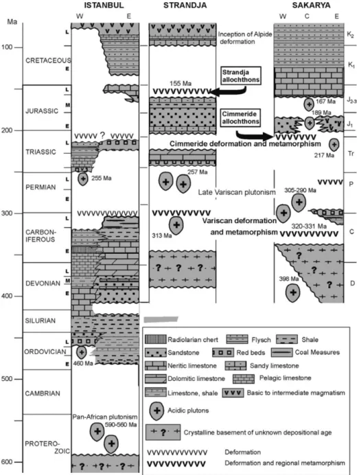
Although presently constituting a discrete and continuous orographic element, the Pontides result from the amalgamation of three tectono-stratigraphic terranes: the Strandja Massif, the İstanbul terrane (İT), and the Sakarya terrane (ST).
20
Fig. 2.4 – Tectonic sketch of Anatolia and surrounding regions (from Okay & Tüysüz, 1999).
There are various often conflicting views on the age and formation of the Intra-Pontide suture, the tectonic boundary between İT and ST (e.g., Şengör & Yılmaz, 1981; Yılmaz et al. 1994; Okay & Tüysüz, 1999; Yiğitbaş et al. 1999; Elmas & Yiğitbaş, 2001, 2005; Robertson & Ustaömer, 2004). It is considered by Okay & Tüysüz (1999) as the result of the progressive closure of an Intra-Pontide ocean during the Senonian. In contrast, according to Şengör & Yılmaz (1981) the Intra-Pontide suture formed in the Early Eocene after an orthogonal opening between İT and ST during the Liassic. Stampfli & Hochard (2009) support a Middle Jurassic collision between İT and ST. Akbayram et al. (2009) favor a Cenomanian collision. Based on thermochronometric data, Cavazza et al. (2012) concluded that İT and ST were mechanically coupled at least since the Paleocene.
The three distinct tectonostratigraphic terranes comprising the Pontides have markedly different geological characteristics. The Strandja Massif constitutes the easternmost part of the vast crystalline basement massif that includes the Rhodope and Serbo-Macedonian massifs. It consists of a Variscan crystalline basement no conformably overlain by a Triassic-Jurassic sedimentary succession (Aydın, 1974; Okay et al. 2006b; Sunal et al. 2006). Senonian andesites and associated granodiorites are widespread (Moore et al. 1980), and form a Late Cretaceous
21
magmatic belt that can be followed all along the Pontides. The İstanbul Terrane is a fragment of continental lithosphere about 400 km long (Fig. 2.4 & 2.5). It is made of a Late Precambrian basement complex overlain by a continuous Ordovician-to-Carboniferous sedimentary succession, which was deformed during the Variscan orogeny (Dean et al. 1997; Görür et al. 1997; Okay et al. 2008a). The late Paleozoic-Mesozoic stratigraphy is similar to that of the Moesian platform and -according to Okay et al. (1994) - prior to the Late Cretaceous opening of the western Black Sea the İT was situated south of the Odessa shelf. The Sakarya Terrane is an elongate lithospheric ribbon stretching >1,500 km from the Aegean sea to the Lesser Caucasus (Fig. 2.4 & 2.5). It is characterized by the absence of in situ Paleozoic sedimentary rocks and by the presence of a characteristic Permo-Triassic subduction-accretion complex (Karakaya-Küre Complex) unconformably overlain by ubiquitous Jurassic shallow-marine deposits (Okay & Göncüoğlu, 2004).
2.3.1 The Strandja Massif
The Strandja Massif forms part of a large crystalline terrane in the southern Balkans, which also includes the Rhodope. It consists of a Variscan crystalline basement overlain by a Triassic-Jurassic continental-to-shallow marine sedimentary sequence. The basement is made of predominantly quartzo-feldspathic gneisses intruded by Late Carboniferous - Early Permian granitoids (Okay et al., 2001; Sunal et al., 2006). The massif forms a belt about 200 km long and up to 50 km wide cropping out in a WNW-ESE direction along the Bulgaria-Turkish border (Fig. 2.5).
22
Fig. 2.5 – Principal units of western Anatolia. I.P.S. Intra-Pontide suture; I.A.S. Izmir-Ankara-Erzincan suture.
A sedimentary sequence of Triassic-Jurassic age lies unconformably on the Variscan basement (Chatalov, 1988). The Triassic series resemble the Germanic Triassic facies with a thick sequence of Lower Triassic continental clastic rocks overlain my Middle Triassic shallow marine carbonates (Hagdorn & Göncüoğlu, 2007). At around the Jurassic-Cretaceous boundary (150-155 My) the Strandja Massif underwent a second phase of deformation and metamorphism involving north- to northeast-vergent thrusting (Okay et al., 2001).
23
Fig. 2.6 – Map showing the distribution of metamorphic rocks in western Turkey (from Rimmelé, 2003; mod. after Bozkurt & Oberhänsli, 2001).
Following this mid-Mesozoic (Cimmerian) orogeny, the metamorphic rocks were unconformably overlain by Cenomanian shallow-marine sandstones. These sandstones pass up into a thick sequence of volcanic and volcanogenic rocks of Late
24
Cretaceous age, which extend into the Sredna-Gora zone in Bulgaria. This Late Cretaceous magmatic belt can be followed all along the Pontides along the Black Sea coast and represents a magmatic arc developed above the northward subducting Neotethyan ocean. In the Strandja Massif the Late Cretaceous magmatism also produced large number of andesitic dykes, sills, small intrusions and the Demirciköy pluton with an age of ca. 78 My (Moore et al., 1980).
Fig. 2.7 – Synthetic stratigraphic sections of the İstanbul, Strandja and Sakarya zone terrane (from Okay, 2008).
25
2.3.2 The İstanbul TerraneThe İstanbul Terrane is a continental fragment, 400 km long and 55 km wide occurring along the southwestern margin of the Black Sea (Figs. 2.5 & 2.6). It has a Late Precambrian crystalline basement characterized by gneiss, amphibolite, meta-volcanic rocks, meta-ophiolite and voluminous Late Precambrian granitoids (Chen et al., 2002; Yiğitbaş et al., 2004; Ustaömer et al., 2005). The basement is mainly exposed in the Bolu Massif north of Bolu and is unconformably overlain by a continuous and well-developed sedimentary succession of Ordovician to Carboniferous in age (Fig. 2.6) (e.g., Görür et al., 1997; Dean et al., 2000).
The Paleozoic rocks were deformed by folding and thrusting during the Carboniferous during the Variscan orogeny and are overlain unconformably by a Triassic sedimentary sequence. The Triassic series is well developed east of İstanbul and shows a typical transgressive development starting with red sandstones with basaltic lava flows, passing up into shallow-marine and then deep-marine limestones, and ending with Upper Triassic deep-sea sandstones and shales. In the western part of the İstanbul Zone, the Jurassic and Lower Cretaceous sequence is absent, and the Paleozoic and Triassic rocks are unconformably overlain by Upper Cretaceous-Paleocene siliciclastic, carbonate and andesitic volcanic rocks. In contrast, in the eastern part of the İstanbul Zone there is a thick Middle Jurassic to Eocene succession marked by small unconformities.
The İstanbul Zone shows a Paleozoic-Mesozoic stratigraphy similar to that of Moesian Platform, and prior to the Late Cretaceous opening of the western Black Sea basin it was situated south of the Odessa shelf (Okay et al., 1994). Together with similar Paleozoic sequences farther west, including the Carnic Alps in Austria and Krajstides in Bulgaria, the İstanbul Zone and its continuation in the Scythian platform formed part of the passive continental margin of Laurasia. With the inception of back-arc spreading in the Late Cretaceous, the İstanbul Zone was rifted off from the Odessa shelf and was translated southward, opening the West Black Sea basin in its wake (Okay et al., 1994).
The İstanbul Terrane is separated from the Sakarya terrane by the Intra-Pontide suture marking the trace of the Intra-Intra-Pontide ocean (Şengör & Yılmaz, 1981). During the Carboniferous the Intra-Pontide ocean probably formed the eastern extension of the Rheic ocean (Okay et al. 2006a; 2008); it closed following the collision of the İstanbul and Sakarya terranes in the mid-Carboniferous. The
26
different Mesozoic stratigraphies of the İstanbul and Sakarya terranes suggest that the Intra-Pontide ocean reopened during the Triassic only to close again in the mid-Cretaceous (Okay, 2008).
2.3.3 The Sakarya Terrane
The Sakarya terrane forms an elongate crustal ribbon extending from the Aegean in the west to the Eastern Pontides in the east (Figs 2.5 & 2.6). In contrast to the İstanbul terrane, the sedimentary sequence starts with Lower Jurassic sandstones, which rest on a complex basement (Fig. 2.7). The crystalline basement of the Sakarya terrane can be broadly divided into three types:
(1) A high-grade Variscan metamorphic sequence of gneiss, amphibolite, marble and scarce meta-peridotite; the high-grade metamorphism is dated to the Carboniferous (330-310 My) by zircon and monazite ages from the Pulur, Kazdağ and Gümüşhane massifs (Topuz et al., 2004; 2007; Okay et al., 2006a). This Variscan basement was probably overlain by Upper Carboniferous molasse, which is only preserved in the Pulur region in the easternmost part of the Sakarya Zone (Okay & Leven, 1996).
(2) Paleozoic granitoids with Devonian, Carboniferous or Permian crystallization ages (Delaloye & Bingöl 2000; Okay et al. 2002; 2006a; Topuz et al. 2007). Small outcrops of these Paleozoic granitoids are scattered throughout the Sakarya terrane, and are unconformable overlain by Jurassic and younger sediments.
(3) A low-grade metamorphic complex (the lower Karakaya Complex) dominated by Permo-Triassic metabasite with lesser amounts of marble and phyllite. The Lower Karakaya Complex represents the Permo-Triassic subduction- accretion complex of the Paleo-Tethys with Late Triassic blueschists and eclogites (Okay & Monié, 1997; Okay et al., 2002), accreted to the margin of Laurussia during the Late Permian to Triassic.
The lower Karakaya complex is overlain by a thick series of strongly deformed clastic and volcanic rocks with exotic blocks of Carboniferous and Permian limestone and radiolarian chert. Several subunits are differentiated within this upper Karakaya complex, which are interpreted as trench turbidites or accreted oceanic islands (Federici et al., 2010). The age of these units ranges from Permian to
27
the Late Triassic. This complex basement was overlain unconformably in the Early Jurassic by a sedimentary and volcanic succession. The Early Jurassic is represented by fluvial to shallow marine sandstone, shale and conglomerate in the western part of the Sakarya Zone; in the eastern part volcanoclastic rocks are typically intercalated with the sandstones (Fig. 2.7). In the central Pontides granitic rocks were intruded into the basement during the Early to Mid Jurassic (Yılmaz & Boztuğ, 1986). The Lower Jurassic clastic and volcanoclastic series are overlain by an Upper Jurassic-Lower Cretaceous limestone sequence, which can be followed throughout the Sakarya Zone (Altıner et al., 1991). In the Eastern Pontides the Upper Jurassic– Lower Cretaceous limestones show an increasingly deeper marine character as they are traced south indicating the presence of a passive margin overlooking an ocean in the south. The limestones are overlain in the mid-Cretaceous by deep sea sandstones and shales marking the onset of the Alpide orogeny. In the Eastern Pontides an ophiolitic mélange was emplaced northward during this period leading to a local phase of contractional deformation (Okay & Şahintürk, 1997).
2.4 THE CYCLADES
Geologically, the Cycladic archipelago is characterized by a series of outcrops of HP/LT rocks: the Cycladic Blueschists. They crop out not only in the Cyclades but also in continental Greece (Olympus, Ossa and Pelion tectonic windows (e.g. Schermer, 1993) and Evia Island (Fig. 2.8) (e.g. Bonneau & Kienast, 1982). One major characteristic of this unit is the high-grade metamorphism and associated severe deformation preventing to easily establish its lithostratigraphy.
The Cycladic Blueschists belt comprises an alternation of metapelites, metabasites and marble. The metabasites are ancient flows, tuffs or basic clocks in a mélange as described in Syros Island (Bonneau et al., 1980). The vertical succession differs from one island to another one. This is mainly due to strong isoclinal folding. However, a general picture can be given as following (Bonneau et al., 1978; 1980).
28
Fig. 2.8 – Simplified tectonic map of the Cyclades (from Blake et al. 1981, mod.)
(1) The deepest unit probably corresponds to the anatectic basement of Ios, Naxos and Paros and the associated post-Variscan sedimentary cover that comprise marbles and chloritoid-kyanite schists, intruded by Triassic granitoids (Engel & Reischmann, 1997; Reischmann, 1997). The marbles contain emery in Naxos and the geochemistry of the metabauxites closely matches that of Jurassic bauxites found elsewhere in the Hellenides and Dinarides (Feenstra, 1985).
(2) The blueschist and eclogite series of alternating marbles, metapelites and metabasites, cropping out in Tinos for instance, probably overlie this basal unit.
(3) An ophiolitic mélange, which is well exposed in the western part of Syros, is the upper metamorphic unit.
The Cycladic blueschists were exhumed in two stages corresponding to two metamorphic episodes (Jolivet & Brun, 2010). The first stage occurred during Eocene Hellenic subduction, during the final stage of the Alpine compressional event, when all units underwent HP-LT metamorphism under blueschist to eclogite facies conditions (Pmax = 20 kbar, Tmax = 600°C). The age of the HP metamorphism
29
event range from 78 to 35 My, with a mean Early Eocene (50-45 My) age (e.g. Trotet et al., 2001a&b; Parra et al., 2002; Ring & Layer, 2003). During subsequent tectonism in the Oligocene and Miocene, the extension associated with the rollback of the Aegean subduction zone determined the collapse of the Hellenic chain and the subsequent exhumation of the blueschists as Cordilleran-type metamorphic core complexes (Lister et al., 1984) with mainly NE-dipping low-angle normal faults (detachments) showing a dominant top-to-the-N or -NE sense of shear (Buick, 1991; Gautier et al., 1993; Vanderhaeghe, 2004). This was associated to a severe HT-LP overprint, coeval with the Aegean post-orogenic extension (Andriessen et al., 1979; Altherr et al., 1982; Wijbrans & McDougall, 1988; Keay et al., 2001). The degree of preservation of the HP-LT assemblages is variable from one island to the other.
2.5 ANATOLIDE-TAURIDE DOMAIN
The Anatolide-Tauride terrane (AT) is a large geological domain in southern Anatolia (Fig. 2.4). It shows Gondwana affinity but is separated from the Arabian platform by the Assyrian (Bitlis-Zagros) suture. To the north, the AT is bounded by the Izmir-Ankara-Erzincan suture, marking the closure of an oceanic domain originally present between the Pontides (Sakarya terrane) and the AT (e.g. Stampfli & Borel, 2004). The Izmir-Ankara-Erzincan suture is the major geological discontinuity in Anatolia as all terranes to the north of it have European (Laurasian) affinity whereas those to the south of it have African (Gondwanian) affinity. The AT forms the bulk of southern Turkey and, in contrast to the Pontides, shows a Palaeozoic stratigraphy similar to the Arabian Platform (Okay, 2008). During the obduction, subduction and continental collision episodes due to the progressive closure of the Izmir-Ankara-Erzincan ocean in the Late Cretaceous and Paleocene, the AT was in the footwall position and therefore underwent much stronger Alpide deformation and regional metamorphism than that observed in the Pontides (i.e. the upper plate). During the mid-Cretaceous a very large body of ophiolite and underlying tectonic slices of ophiolitic mélange were emplaced southward over the AT (Okay, 2008). The northern margin of the AT underwent HP/LT (high pressure/low temperature) metamorphism at depths of over 70 km under this oceanic thrust sheet. Erosional remnants of this thrust sheet of ophiolite and ophiolitic mélange occur throughout the AT. Although widely called a mélange, it
30
generally lacks an all-encompassing matrix, and represents rather a highly sheared Cretaceous accretionary complex. With the inception of continental collision in the Paleocene, the Anatolide-Tauride terrane was internally sliced and formed a south- to southeast-vergent thrust pile. Contraction continued until the Early to Middle Miocene in western Turkey and is still continuing in eastern Anatolia. The last significant episode of mechanical coupling along the Bitlis-Zagros suture zone occurred in the Middle Miocene, as shown by the thermochronological dataset of Okay et al. (2010).
In western Anatolia the different types and ages of Alpide metamorphism leads to the subdivision of the Anatolide-Tauride terrane into zones with different metamorphic features, in a similar manner to the subdivision of the Western Alps into Helvetics and Penninic zones (Okay, 2008). From north to south, there are three main regional metamorphic zones in the Anatolide-Taurides of western Anatolia: (i) a Cretaceous blueschist belt (the Tavşanlı Zone), (ii) a lower grade high-pressure metamorphic belt (the Afyon Zone), and (iii) a Barrovian-type Eocene metamorphic belt (the Menderes Massif) (Fig. 2.4). To the northwest of the Menderes Massif there is a belt of chaotically deformed uppermost Cretaceous-Paleocene flysch with Triassic to Cretaceous limestone blocks. This Bornova Flysch Zone has an anomalous position between the Izmir-Ankara suture and the Menderes Massif. The Taurides, which lie south of the metamorphic regions, consist of a stack of thrust sheets of Paleozoic and Mesozoic sedimentary rocks (e.g. Gutnic et al., 1979; Özgül, 1984). The Central Anatolian Crystalline Complex north of the Taurides is a region of metamorphic and plutonic rocks with Cretaceous isotopic ages. The question of the affinity of the Central Anatolian Crystalline Complex, whether part of the Anatolide-Tauride terrane, or a single terrane on its own, is not yet solved (Okay, 2008).
Following is a synthetic description of the principal unit of the Anatolide-Tauride domain.
2.5.1 Bornova Flysch Zone
The Bornova Flysch Zone is a 50 to 90 km wide and ~230 km long tectonic zone between the Menderes Massif and the İzmir-Ankara suture (Fig. 2.4). It consists of chaotically deformed Upper Maastrichtian-Lower Paleocene greywacke and shale with blocks of Mesozoic limestone, mafic volcanic rock, radiolarian chert and serpentinite (Erdoğan, 1990; Okay et al., 1996). Many of the blocks must have been
31
initially olistoliths but were subsequently tectonized. The size of the Mesozoic limestone blocks can be as large as 10 km or more, although some of the large “blocks” may consist of tectonically juxtaposed smaller blocks. The proportion of the ophiolitic clasts in the sheared clastic matrix increases eastward and the Bornova flysch passes laterally to an ophiolitic mélange. In the east the Bornova Flysch Zone is in contact with the Menderes Massif along post-Eocene normal faults.
The Bornova Flysch zone has formed by the rapid foundering and destruction of the Anatolide-Tauride carbonate platform during the Maastrichtian-early Paleocene. Large sections of relatively intact carbonate platform are exposed on the island of Chios and on the adjacent Karaburun Peninsula, where the stratigraphy is also most complete (Erdoğan et al., 1990). The blocks in the Bornova Flysch Zone generally consist of Triassic, Jurassic and Cretaceous marine limestones. Late Cretaceous is represented by deep marine red limestones, which lie unconformably over the older carbonates. The stratigraphy of some of the blocks in the Bornova Flysch Zone is similar to those described from the Lycian nappes, 300 km to the southeast (Okay & Altıner, 2007). This biostratigraphic similarity lends strong support for a northerly origin of the Lycian nappes. The flysch and the blocks are unconformably overlain by undeformed late Early Eocene neritic limestones. This constrains the age of the deformation in the Bornova Flysch Zone to Late Paleocene.
2.5.2 The Tavşanlı Zone
The Tavşanlı Zone is a regional blueschist belt in northwest Turkey, ~250 km long and ~50 km wide, immediately south of the main Neo-Tethyan suture (Figs. 2.4 & 2.5). The blueschist sequence in the Tavşanlı Zone consists of Permo-Triassic metapelitic schists at the base, Mesozoic marbles in the middle and a series of metabasite, metachert and phyllite at the top (Okay, 1984). The blueschists represent the subducted and subsequently exhumed passive continental margin of the Anatolide-Tauride terrane. Phengite Rb-Sr and Ar-Ar data from the blueschists indicate a Late Cretaceous (80 ± 5 My) age for the HP/LT metamorphism (Sherlock et al., 1999). The coherent blueschist sequence is tectonically overlain by a Cretaceous accretionary complex of basalt, radiolarian chert and pelagic shale. The accretionary complex exhibits generally a low-grade incipient blueschist metamorphism. Large tectonic slabs of ophiolite, predominantly peridotite, lie over the coherent blueschists or over the accretionary complex. The whole
32
tectonostratigraphic pile is intruded by calc-alkaline Eocene plutons, which form an elongate belt, 400 km long and 60 km wide, extending from the Sivrihisar region in the central Anatolia to the Marmara Sea (e.g. Harris et al., 1994; Okay & Satır, 2006; Altunkaynak, 2007). This Eocene magmatic belt constitutes either a magmatic arc or has formed as a result of slab break-off. Locally a low pressure - high temperature metamorphism has accompanied the intrusion of granodiorites.
2.5.3 The Afyon Zone
The Afyon Zone occupies the region between the Menderes Massif and the Tavşanlı Zone (Figs. 2.4 & 2.5). It exhibits the typical Tauride stratigraphy with a mixed carbonate clastic Paleozoic series overlain by Mesozoic marbles but shows a low-grade medium to high pressure metamorphism characterized by extensive occurrences carpholite and local sodic amphibole (Candan et al., 2005). The metamorphic rocks are tectonically overlain by an ophiolitic mélange and by ophiolites. The age of regional metamorphism is not analytically determined but is stratigraphically constrained as latest Cretaceous to Paleocene.
2.5.4 Central Anatolian Crystalline Complex
The Central Anatolian Crystalline Complex is a large region of metamorphic and granitic rocks with Cretaceous isotopic ages. An extensive Neogene sedimentary and volcanic cover leads to the subdivision of the Central Anatolian Crystalline complex into several submassifs; the important ones include Kırşehir, Akdağ and Niğde massifs (Fig. 2.9). The Central Anatolian Crystalline complex is regarded either as the metamorphosed northern margin of the Anatolide-Tauride terrane (e.g. Poisson et al., 1996; Yalınız et al., 2000) or a distinct terrane separated from the Anatolide-Taurides by the Inner Tauride Suture (Şengör et al., 1982; Görür & Tüysüz, 2001; Whitney & Hamilton, 2004). The metamorphic rocks of the Central Anatolian Crystalline Complex constitute a coherent metasedimentary sequence of gneiss, micaschist, metaquarzite, marble and calc-silicate rock, which are isoclinally folded and multiply deformed (Seymen, 1983).
33
Fig. 2.9 – Geological map of the Central Anatolian Crystalline complex (from Okay, 2008; mod. after Whitney & Dilek 2001).
The regional metamorphism varies from greenschist to granulite facies and is of high temperature-medium/low pressure type. The maximum pressure attained during the metamorphism is ca. 6 kbar corresponding to depths of ca. 20 km (Whitney et al., 2003). This low- to medium-pressure metamorphism was overprinted in several submassifs by a lower pressure metamorphism associated with the emplacement of granitic intrusions. The age of regional metamorphism is Late Cretaceous (91-85 My) based on monazite and zircon U-Pb dating (Whitney et al., 2003; Whitney & Hamilton, 2004). The metamorphic rocks are tectonically overlain by an unmetamorphosed Late Cretaceous accretionary complex of basalt, radiolarian chert, pelagic limestone, sandstone and serpentinite. The accretionary complex as well as the metamorphic rocks is intruded by granitic rocks, which cover large areas in the Central Anatolian Crystalline Complex. The plutonic rocks are
34
mainly quartz-monzonites, quartz-monzodiorites, monzonites and monzodiorites with a calc-alkaline character, and their trace element geochemistry is compatible with a syn- to post-collisional tectonic setting (Akıman et al., 1993; Erler & Göncüoğlu, 1996; İlbeyli et al., 2004). There are also minor crustally derived peraluminous plutons. The K/Ar biotite and hornblende, titanite and zircon ages from the granitic rocks generally range from 95 to 70 My (Whitney et al., 2003; Köksal et al., 2004; Boztuğ et al., 2007). An upper age limit on the granitic magmatism as well as on regional metamorphism is provided by the Upper Maastrichtian terrigenous to shallow marine clastic and carbonate rocks, which lie unconformably on the metamorphic as well as on the granitic rocks (Seymen, 1983).
2.5.5 The Menderes Massif
2.5.5.1 General description and definition
The Menderes Massif of western Anatolia is exposed in a tectonic window of approximately 200×100 km exposing metamorphic rocks belonging to the basement complex of the Anatolide-Tauride terrane (Figs. 2.4, 2.5 & 2.6). Topographically, the central west coast of the Anatolian Peninsula is characterized by the transition from the Anatolian Plateau to the Aegean sea. The landforms of the area are mainly controlled by a series of E-W and ESE-WNW–oriented horsts and grabens that delimit mountain ranges and highlands. This Basin and Range-type topography is a consequence of Neogene-to-Recent normal and strike-slip faulting.
The Menderes Massif is tectonically overlain by nappes of the İzmir-Ankara Suture Zone (Şengör & Yilmaz, 1981) on its northern flank (including the Bornova Flysch zone), the Afyon zone on its eastern border (Şengör et al., 1984), and the Lycian nappes (Brunn et al., 1970; de Graciansky, 1972; Poisson, 1977) on its southern flank (Fig. 2.3, 2.4 & 2.5). The massif is described as the assemblage of a Precambrian core of micaschists, augen gneiss and minor granulite and eclogite intruded by voluminous metagranites with latest Precambrian (550 My) intrusion ages (e.g. Schuiling, 1962; de Graciansky, 1966; Dürr, 1975; Şengör et al., 1984). This Precambrian crystalline basement is overlain by Paleozoic to Lower Tertiary metasedimentary rocks constituting the ‘cover’ series. The oldest fossiliferous series in the cover sequence are the Permo-Carboniferous marble, quartzite and phyllite of the so-called Göktepe Formation. Through a clastic interval the Göktepe Formation
35
is overlain by a thick sequence of Mesozoic marbles. The top part of the marbles sequence contains an Eocene flysch sequence with serpentinite olistostrome.
In the Menderes Massif, pronounced magmatic activity occurred at the Proterozoic-Cambrian boundary (Hetzel & Reischmann, 1996; Dannat & Reischmann, 1999; Gessner et al., 2001a; Reischmann & Loos, 2001), in the mid-Triassic (Dannat, 1997; Koralay et al., 2001), and in the Miocene (Hetzel et al., 1995a; Collins et al., 2002). In the Cycladic zone, the granitic basement is of Carboniferous age (Reischmann, 1997; Engel & Reischmann, 1997). In addition, there were very limited Triassic intrusions (Reischmann, 1997; Ring et al., 1999b) and other prominent Miocene to Holocene magmatic activity in the Cycladic zone (Altherr et al., 1982).
Menderes Nappes
According to some authors (e.g. Ring et al., 1999b; Gessner et al., 2001a, 2001c) the geological structure of the Menderes Massif consists into a series of nappes. Although these nappes were never effectively found in field, these consist, from top to bottom, of the (1) Selimiye Nappe, an upper metasedimentary succession of intercalated marble and calc-schist; (2) Çine Nappe, a Proterozoic-Cambrian basement succession; (3) Bozdağ Nappe, a metapelitic succession with abundant amphibolite and a few marble lenses and (4) Bayındır Nappe, a lower metasedimentary succession (Ring et al., 1999b; Gessner et al., 2001a, 2001c). The structurally lowest unit exposed in the Menderes nappes, the Bayındır Nappe, is affected only by one major Alpine tectonometamorphic event, whereas in the overlying Bozdağ, Çine, and Selimiye Nappes, pre-Alpine and Alpine events are documented (Fig. 2.10) (Ring et al., 1999b; Gessner et al., 2001a, 2001c).
Selimiye Nappe
The Selimiye Nappe contains a metasedimentary sequence the basal part of which is of Precambrian age (Hetzel & Reischmann, 1996; Loos & Reischmann, 1999). The top of the nappe pile is made of Paleozoic metapelite, metabasite, and marble (Schuiling, 1962; Çağlayan et al., 1980; Loos & Reischmann, 1999; Régnier et al., 2003; Gessner et al., 2004).
36
Fig. 2.10 – Pre-Alpine and Alpine events DPA and DA1 to DA5 in the tectonic units of the Anatolide Belt in western Turkey. Temperature estimates after Gessner et al. (2001c), except for Çine and Bozdağ Nappes (Ring et al., 2001b) and Dilek Nappe (Will et al., 1998). Diagram indicates that the Anatolide Belt was assembled during DA3; subscripts PA and A denote pre-Alpine and Alpine deformation ages, respectively. After Gessner et al. (2001c).
The tectonometamorphic history of the Selimiye Nappe remains controversial. Interpretations of the greenschist-facies Selimiye Shear Zone include (1) Alpine shortening (Gessner et al., 2001a, 2004); (2) Precambrian and Alpine polymetamorphic deformation (Régnier et al., 2003); (3) post-Precambrian, pre-Alpine monometamorphic deformation (Régnier et al., 2006); (4) folding during Alpine shortening (Erdoğan & Güngör, 2004); and (5) late Alpine extension (Bozkurt & Park, 1994). Bozkurt & Park (1994) have interpreted this shear zone as an extensional feature, but there is inconsistent evidence for a telescoped metamorphic field gradient or for a change in cooling history across it.
Another contentious issue is that a number of authors claim that the granitic rocks intrude lithologies that can be correlated with Mesozoic sediments and are therefore “Alpine” in age (Şengör et al., 1984; Erdoğan & Güngör, 1992; 2004; Bozkurt et al., 1993; 2001), whereas radiometric ages of the intrusions give late Proterozoic to Cambrian ages (Reischmann et al., 1991; Hetzel & Reischmann, 1996; Gessner et al., 2001a; 2004); thus lithological correlations in highly deformed metapelites can be problematic. Recently Candan et al. (2011) concluded, by