!"#$%&'()*+*(,*%')%-(./+'(0*(#12%
3+,$1*'2'45%67!8
9':*(1;%6<=68%>*?+@1+5%67!8
-:/#*:%?5
3AA@(#1%>2'+*(B1(';%91+/1%&$/1+1%9'(#*,,$/;%C'AA*221%C/(12:/
D@01(A%1(:%*(./+'(0*(#12%A@A#1/(1?/2/#5E%
F*AA'(A%)+'0%#$*%G1A#%*,'A5A#*0A%')%-@+'G*%1(:%H'+#$*+(%3)+/,1
UNDER THE PATRONAGE OF
Dipartimento di Scienze della Vita LPP - Laboratorio di Palinologia e Paleobotanica
---
Contents
Presentation SESSION 1
DETECTING HUMAN IMPACT: THE ABG (ARCHEO-BIO-GEO) RESEARCH Mauro Cremaschi
Settlements, Crops, Woods. Land use and resources in a changing environment at the time of the Terramare (XVI - XII century BC, N Italy)
Stefano Remo Luigi Campana, Ken Saito
Emptyscapes: filling an 'empty' Mediterranean landscape mapping the archaeological continuum Ladislav Smejda
Recent surveys of ancient human impact on soil chemistry in Messara Plain, Crete
Alessandro Panetta, Valentina Pescini, Roberta Cevasco, Nicola Gabellieri, Carlo Montanari, Diego Moreno
Towards an Environmental Resources Archaeology, escaping from site (and ‘off-site’) Petr Pokorný, Petr Šída, Lucie Juřičková, Michaela Ptáková, Jan Novák, Přemysl Bobek
1st millennium BC forest ecosystem transformation in Bohemian sandstone areas: Were humans involved?
SESSION 2
DETECTING HUMAN IMPACT: THE ABG (ARCHEO-BIO-GEO) RESEARCH Emanuele Vaccaro, Michael MacKinnon, Anna Maria Mercuri Mercuri
Cultural landscape and local economy in central Sicily: Philosophiana between the Roman and Middle Byzantine periods
Assunta Florenzano
Palynological approach to pastoral activities reconstructions in S Italy: a palaeoecological contribution to support biodiversity awareness
Mauro Rottoli, Michele Bassetti, Nicola Degasperi, Nicoletta Martinelli, Roberto Micheli Agriculture, forestal resources and Late Neolithic daily life at the pile-dwelling site of Palù di Livenza (NE Italy)
Roberto Micheli, Michele Bassetti, Federico Bernardini, Nicola Degasperi, Vanni Lughi, Mauro Rottoli, Lisa Vaccari, Franco Zanini
Chewing tar at the Late Neolithic pile-dwelling site of Palù di Livenza (NE Italy) Jitka Kosňovská, Věra Čulíková, Veronika Komárková, Adéla Pokorná, Jaromír Beneš
Structure and useful plant dynamics on Prague Castle: archaeobotanical and ethnohistorical perspective
SESSION 3
LONG-TERM ENVIRONMENTAL RECONSTRUCTION FOR LANDSCAPE MANAGEMENT
Yannick Miras, Michela Mariani, Paul M. Ledger, Léo Chassiot, Marlène Lavrieux
Holocene vegetation dynamics and land-cover estimates in Auvergne: key tools to landscape management 2 8 16 19 22 26 30 33 36 41 45
EMPTYSCAPES
Towards Filling Gaps in Mediterranean Landscape Archaeology
Stefano Campana1, Ken Saito1
1University of Siena, Landscape Archaeology & Remote Sensing LAB,
Department of History and Cultural Heritage, Siena, Italy Email address: [email protected]
‘On one matter there is universal agreement: the appearance of practically every square metre in the Mediterranean today, save a few remote fastnesses, has been altered, directly or indirectly, by the past activity of people’ (Cyprian Broodbank 2013: 71) 'What at first appeared to be merely a period of technical re-equipment has produced profound practical, theoretical and philosophical problems to which the new archaeologies have responded with diverse new methods, new observations, new paradigms and new theory' (David Clarke 1973: 17)
Keywords: Mediterranean, Italy, empty spaces, landscape, archaeological continuum, holistic
The Emptyscapes project
The aim of the project is to use the ‘traditional’ methods of landscape survey in partnership with large-scale geophysical prospection, in due course airborne laser scanning, geo-archaeological and bio-archaeological. The research area is a stretch of a rural valley near the ancient city of Rusellae in southern Tuscany exploring completely new ground of a rural emptyscape.
The Etruscan and Roman city of Rusellae has been relatively well explored in the past, with a history running in fairly well-defined phases of foundation, elaboration and decline from the 8th or 9th century BC to the early 12th century AD, when primacy and the local bishopric were
ceded to the growing town of Grosseto a few km to the south-west. At least some of the developments within the ancient city are known or suspected to have been matched by developments or transformations within the open landscape of the valley, including the foundation and decline of rural villas and (possibly) of centuriation during the Roman period. Villages of one kind or another may also have been present during the Iron Age and Early Medieval periods, though their location and form remain unclear (Nicosia and Poggesi 2011). Today, the slopes either side of the valley are largely wooded. The relatively flat and topographically undistinctive landscape between present-day Grosseto and the site of Rusellae is now displays a rotating mixture of arable cultivation and pasture, dotted with small areas of woodland, vineyards and olive cultivation. A trapeze-shaped sample transect covering 2500 ha of the valley and hillslopes to the south-east of Rusellae was chosen as offering opportunities to explore a range of environmental and archaeological contexts, with lowland fields appropriate for magnetic survey flanked by wooded hillslopes which in due course will act as a test-bed for high-resolution laser scanning.
Previous field survey, aerial photography and the detection of
archaeological evidence
From the late 1970s onwards the University of Siena has fostered a systematic programme of landscape and archaeological investigation within southern Tuscany, including the Rusellae area. As a result the area now has a substantial database and GIS, developed mainly through the examination and analysis of archaeological evidence and ancient literature, documentary and
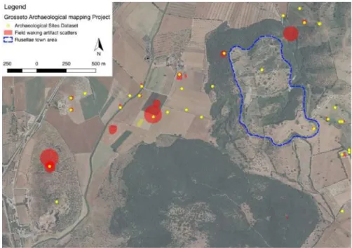
epigraphic sources, place-name evidence, systematic field-walking survey and aerial photography, along with excavations of various scales. Despite this, many important archaeological questions still remain unresolved. Moreorver, if we look at the 1:100,000 distribution map and switch instead to the 1:10,000 it is easy to appreciate how the ‘empty spaces’ predominate (Fig. 1).
Figure 1 - Close up of the distribution map of sites detected by ‘traditional’ archaeological survey towards the north-eastern end of the sample transect, at a scale of 1:10,000.
This realisation raises a crucial question: what are we missing? The answer lies before our very eyes: the landscape and its transformations across time.
In an attempt to address the conundrum of the ‘empty phases’ and to fill what at present appear to be ‘empty spaces’, the Emptyscapes project has been making an intensive study of the sample transect at Rusellae so as to explore some key questions relating to the major cities of Rusellae, Grosseto and Vetulonium: for instance the urbanisation of the Etruscan cities and in particular their relationship with the surrounding countryside, the Romanization of the cities and the landscape, the process of Christianisation and finally the impact on settlement, society and economy of the end of the Antiquity and the beginning of the Middle Ages (new ruling classes, ‘incastellamento’, etc).
In the attempt to improve our understanding of the sample area we have so far collected around 450 ha of geophysical data (420 ha of magnetic and 30 ha of resistivity data); we have also undertaken exploratory aerial survey in the area and have recently commenced fieldwork with the purpose of collecting archaeological, geo-archaeological and bio-archaeological evidence within the chosen transect. However, after this amount of scientific effort, have we answered our research questions? Which new scenarios have been opened up? What new questions can we now ask? Has our understanding of archaeological and landscape transformations within the sample transect been substantially improved?
To answer these questions, or at least to provide a partial response, this article will present just one example (among many other available in this area) that will illustrate the impact of the work undertaken so far on our understanding of the area and of the overall potential of this approach within a carefully chosen tract of ancient landscape. Aerial survey but especially magnetic prospection has produced entirely unexpected results. In the north-east block, the magnetic data shows a cluster of anomalies that can be readily interpreted as anthropogenic functional
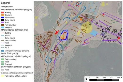
elements and natural features within the local landscape: cultivation patterns, road systems, buildings and geomorphological features. Within this complex there lies a double-ditched enclosure (marked in blue in Fig. 2), close alongside the present course of the river Salica. The enclosure was first identified in the magnetic data and then confirmed by intensive field-walking survey (Campana 2018).
Figure 2 - Overlapping of the site distribution and archaeological mapping of magnetic measurements (Mag) as well as oblique (oAP) and vertical (vAP) aerial photography.
Within the 0.8 ha central area of the enclosure intense artefact scatters coincided with a number of clear magnetic anomalies, the size and shape of which suggested interpretation as buildings. In this case field observation and artefact collection were critical in identifying key features of the site: a significant variation in elevation (of as much as 1.5 m) matching the features visible on the magnetic map, and artefact scatters clearly indicating a medieval dating. What has been revealed here is a previously unsuspected artificial mound, or alternatively a settlement occupying a slight natural eminence within the local topography. Moreover, in the neighbourhood of the site, but mostly to the south and the west of the river Salica, magnetic anomalies reveal a pattern of field boundaries, roads and palaeo-riverbeds. The outstanding character of the magnetic data and local topography prompted a borehole survey and an intensive programme of artefact collection within a virtual grid of 10 m x 10 m ‘cells’, aimed at establishing the chronological range and function of the site and at providing a more detailed picture of the match between the magnetic measurements, micromorphology and artefacts distribution. Analysis of the collected artefacts showed a quite distinct pattern of intensive human activity deriving predominantly from the early 10th to the early or mid 12th century AD.
On the basis of comparative studies of shape, size, morphology, artefact assemblage and chronological range this site can confidently be interpreted as a lowland medieval settlement that shares significant characteristics with three others identified during recent survey work in or close to the Grosseto lowland. It is possible, moreover, that the adjacent field system and road could be associated with the same cultural context and chronological range. Unfortunately, borehole survey program has been quite ineffective dating and generally improving our understanding of field boundaries and therefore proper test-excavation program is needed. However, in the meanwhile, we implemented comparative studies showing clear resemblances here to sites in Puglia revealed in the first instance through aerial photography (Guaitoli 2003), many of them sharing a general appearance to our field system in terms of size, shape and overall pattern, and in some cases also to the shape of the settlements themselves. However, the
settlement and in particular the field system (if genuinely associated with one another) illustrate an extraordinary vital stage of a society that had the capacity and/or need to reorganize settlement and landscape patterns, perhaps removing almost all vestiges of older patterns in the process. As a final remark in this context we should perhaps emphasize the complexity of the area under investigation. Past studies identified this as one of the most important areas within the Grosseto plain for agricultural production (Citter and Arnoldus 2007). Moreover, the present survey has produced clear evidence of a high level of hydrogeological instability in this locality. Therefore, the creation of this new settlement and perhaps field system, whether financed initially by the ruling classes or undertaken of their own volition by an existing rural community, would have required advanced know-how of the local area, along with social resources in terms of labour and productive capacity, to fulfil the project in the first place and to retain it as a viable social and productive concern over time.
Targeted small-scale excavation
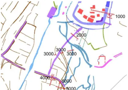
To further improve understanding of the historical development and to provide feedback to the general research strategy a programme of targeted small-scale excavation was implemented during summer 2017. The excavation work was aimed at sampling the air-photo and geophysical anomalies interpreted as field boundaries and identifying dating evidence and bioarchaeological data to better explain the local pattern of land use and its transformation across time. The excavations were also targeted at the double-ditched enclosure in the hope of better defining the chronology and fundamental characteristics of the settlement and its possible connection to the adjacent field system. In the event the excavations revealed a substantial series of stratigraphical relationships and paleo-soils from which it was possible to collect samples for geomorphological, bioarchaeological and pollen analysis; these promise to provide a better understating of the past environment at various stages in the development of the local landscape pattern (Fig. 3). At the time of writing, towards the early 2018, analysis of the collected observations and samples is still in its initial stages but it can already be said that almost all of the features identified in the remote-sensing data were also readily traceable in the excavation trenches, along with paleo-soils and other relevant items not represented in the survey data.
Figure 3 - Targeted small-scale excavations near Rusellae. Numbered and dashed red polygons show the outlines of the sample excavations carried out in the summer of 2017.
The excavations in trench 1000 confirmed that the fortification system of the settlement consisted of two ditches, each probably accompanied by an internal bank, a paleo-soil containing medieval pottery and in the case of the inner bank and ditch, by a wall too.
In five of the six test excavations clearly-defined anthropic paleo-soils were identified. Within the double-ditched enclosure the top of the paleo-soil (left undisturbed during the excavation) lay about 30 cm below the present surface, immediately beneath the recent ploughsoil. Outside the enclosure the thickness of the paleo-soil was seen to be about 30-40 cm, extending beneath the recent ploughsoil to a depth of about 60-70 cm from the present ground surface. Both inside and outside the enclosure the paleo-soil was relatively dark in colour and included plentiful organic elements and medieval pottery (Fig. 4). The only excavation trench that did not reveal this paleo-soil (trench 3000) was only excavated to a depth of 50 cm before being abandoned after of heavy rain made it impractical to continue the excavation work. There was no surviving evidence of deeper anthropic paleo-soils. Stratified deposits of Roman and Etruscan age were also entirely lacking, surprisingly so in a location situated only a short distance from a city that played a substantial role in the region throughout those periods. At the east end of trench 1000 and at both ends of trench 2000 the excavations were carried to a depth of up to 3.5 m below the present surface without revealing any sign of anthropic paleo-soils at these lower levels. In this connection, however, it is worth adding that both past and recent field-walking survey and artefact collection across this area produced only a very thin scatter of pre-medieval material, the overwhelming majority of the surface finds belonging to the 10th to 12th century AD, with
only a very few finds from the early Middle Ages and Late Antiquity. Pottery and any other kinds of material from the Etruscan and mature Roman periods were exceptionally rare. The detailed examination and analysis of the sections in partnership with geomorphologists from the University of Siena, highlighted the presence of complex geomorphological activity and the widespread presence of clay layers produced by the settling of sediments in still water (Fig. 4). A reasonable interpretation would see this area as characterized by a small expanse of open water during Etruscan and Roman times, later reclaimed as dry land in Late Antiquity or perhaps during the very early part of the Middle Ages.
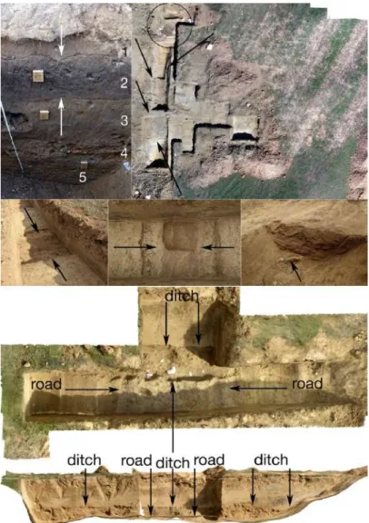
Figure 4 - Targeted small-scale excavations near Rusellae. Top left: section of trench 2000 showing the clearly defined topsoil (1), black paleo-soil (2), and natural clay deposit mixed with other natural sediments (3, 4, 5). Top right: drone-derived ortophoto of trench 4000 showing the the road (indicated by black arrows) and the close proximity of the two Lombard burials (black circle). Central row: trench 5000 showing a ditch filled (from left to right) by sand deposits at the top and gravels and ceramic material at the bottom. Bottom: plan and section of trench 6000; the plan view at the top is a drone-based orthophoto showing the road (running top to bottom) where it is clearly overlain and cut (from left to right) by the small ditch originally identified in trench 5000; the lowest part of the illustration is derived from a 3D simulation showing the section of the trench, with light-coloured ploughsoil at the top and arrows to mark the upper surface of the darker-coloured ditch-fill where it clearly overlies the arrowed surface of the road at the very bottom
Sample trench 4000 was located so as to intersect a magnetic feature that had been interpreted as part of a road system, at this point running approximately east to west. The excavation confirmed the presence of a substantial hardstanding appropriate as the foundation levels of a road. A short distance to the north and at the same depth as the road there were discovered two inhumation burials. One was in a simple fossa terranea, devoid of grave goods, while the other had a stone cover-slab and contained a brooch, a necklace and a pair of earrings typical of the early Lombard period in this part of Italy. In the survey datasets there was no trace of any settlement within 150 m of the burials – the double-ditched enclosure lies 200 m to the north-east and on current interpretations belongs to a considerably later date. It therefore seems reasonable to suggest a connection between the road system and the burials, and to infer that the road may still have been in use when the graves were dug.
In trench 5000 one of the small ditches that appeared from the geophysical data to serve as field boundaries was shown to have a filling of sand above a thin layer of gravel at the very bottom, with organic remains and plentiful fragments of charcoal along with sherds of pottery that appeared to be entirely consistent with medieval material of the 10th to 12th century AD. The
fillings were systematically sampled for environmental analysis and radiocarbon dating. If current impressions are confirmed, it seems highly likely that this part of the field system identified through non-destructive survey will be confirmed as fitting within the same chronological bracket as the double-ditched settlement (Fig. 4).
Trench 6000 was directed at the relationship between the road uncovered in trench 4000 and the ditch identified as a field boundary in trench 5000. The field boundary clearly overlay and partially cut the road, the surface of which lay approximately 40 cm below the level from which the ditch was cut. The road therefore seems to have been out of use by the time the field boundary began to collect pottery and other material provisionally dated to the 10th to 12th
century, like that associated with the double-ditched settlement located about 200 m to the north (Fig. 4). Within the current state of data processing the evidence collected so far provides an entirely new and now broadly phased picture of the area under investigation. Studies of local geomorphological dynamics have revealed the presence of still water within a probable pool or wet area which on present evidence seems to be present throughout the Etruscan and Roman periods and perhaps onward into Late Antiquity. After this, pottery began to appear, as does evidence of a new feature in the form of a road or road-system, attesting to a new phase of activity probably associated with reclamation of the wet area or to climate change (or perhaps to a combination of the two). During or soon after Late Antiquity it appears that the wetland area had already been reclaimed and a high-quality road built across it, an enterprise that would have demanded significant economic resources and technical expertise. At the beginning of the 7th
century two Lombard burials were placed alongside the road, roughly in the centre of the area examined so far (Fig. 5). A little later a small amount of 8th and 9th century pottery found its way onto the area which then saw the major development of the double-ditched enclosure and its apparently associated field system during the 10th to 12th century. By this time there was a
wide-spreading medieval paleo-soil within an apparently well-structured agrarian landscape characterized by a regular system of small ditches defining fields or property boundaries and no doubt providing local drainage.
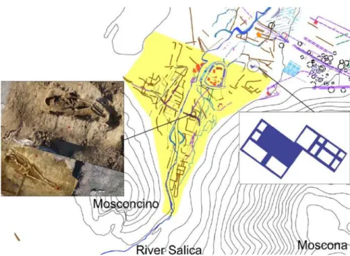
Figure 5 - The north-eastern part of the Rusellae study area: the yellow area represents the hypothetical wetland or small lake bounded to the north by a workshop or productive centre dated by surface finds to the Roman period (inset on the right) while in the other directions there are obvious boundaries in the higher land of Moscona and Mosconcino. The southern limit is very narrow and available maps show that is marked by a sort of dam, either natural or anthropic, which may become the focus future small-scale excavation. The inset on the left shows an orthophoto of the two burials discovered near the centre of the area alongside the road. The inset on the right shows the Roman-period complex at the northern end of the wetland area.
Conclusions
The survey and interpretation described above have borne out the potential effectiveness of this approach to rural landscapes in Italy, and by implication in much of the Mediterranean area, showing clearly that the concept of the archaeological continuum is a reality that lies almost within our grasp, even in the specific environmental and archaeological conditions of the Mediterranean world. Previous research strategies in Italy have been largely reactive, with a focus on the known or partly known through the use of methodologies, which reveal only a limited part of the potentially recoverable evidence. Archaeological distribution maps, particularly for the Rusellae area, consisted until very recently of a collection of dots within a sea of ‘emptiness’. Indeed, in most cases the empty spaces seemed to be in the majority. If we can overcome this limitation, as has been demonstrated here, we will be able to open up completely new opportunities to explore a wide range of as yet unanswered archaeological and historical questions. In the writer’s view this capacity to uncover and document previously inaccessible evidence is important for two key reasons, the first being essentially archaeological while the second methodological. The identification, for instance, of a previously unsuspected funerary landscape, field systems, enclosures or of structured medieval settlements on the lowland around Rusellae, and so forth, cannot be dismissed as the simple addition of dots or detail to the mapped record of the area. The newly discovered enclosures represent a form of settlement previously unknown in lowland Tuscany (Settia et al. 2013). Archaeological concepts developed in recent decades, of a largely ‘uninhabited’ Tuscan countryside in the formative centuries of the medieval period, have thus been thrown open to further discussion. The results achieved so far are also important for a methodological reason. Given that exactly the same pattern of advance in data capture and archaeological understanding has ensued wherever these new holistic approach to landscape studies have been applied in the UK (Powlesland 2009) and in the continental Europe (Neubauer 2013) it is a reasonable to argue on the basis of the results achieved so far that the same partnership of traditional and innovative
methodologies ought to continue producing the same improvement in Italy too, helping us to examine and possibly revise present perceptions about the content and progressive transformations of the Italian countryside.
Acknowledgements
The research would not have been possible without the financial support of the Marie Curie action for the Emptyscapes project (FP7-PEOPLE-2013-IEF n. 628338), the Culture 2007 ArchaeoLandscapes Europe project (Grant Agreement nr. 2010/1486/001-001), ARCUS and two Italian research grants within the scheme of the Project for Research of Relevant National Interest (PRIN 2008 and PRIN 2015). The generosity and support of these institutions have been greatly appreciated. Special thanks are also due to two very good friends who have followed and inspired so much of my research work since early in my career, Chris Musson and Prof Dominic Powlesland. As ever, they have helped with constructive criticism and comments throughout all stages of this project. I could never thank them enough. Moreover, I am very grateful to Chris Musson who patiently and willingly revised the final text, improving the English language and enhancing the overall readability. I am further indebted to Dr Emanuele Vaccaro for artefact collection and pottery analysis. Grateful thanks, too, go to Prof Charles French, Prof Pierluigi Pieruccini and Davide Susini for their support and guidance in geo-archaeological research, with particular regard to the organization of the borehole survey work and test excavation in 2015 and 2017. Thanks, are also due to Prof. Gaetano di Pasquale and Dr. Mauro Buonincontri for the implementation and discussion of the results of archaeobotanical analysis on macro-remains and to Anna Maria Mercuri and her team for palynological analyses. Test-excavations implemented during summer season 2017 were generously supported by the local administration of Grosseto and the Province of Grosseto, enabling a small team of highly motivated archaeologists to achieve outstanding results in a very short time; for this my gratitude goes to Dr Cristina Felici, Dr Marianna Cirillo, Dr Ken Saito and Alfredo Biliotti. Sincere thanks are also owed to the Archaeological Superintendency of Tuscany, and in particular to Dr Andrea Pessina, Dr Arch Anna Di Bene, and Dr Gabriella Poggesi for the intellectual debate and problem-solving approach.
References
BROODBANK, C. 2013: The Making of the Middle Sea a History of the Mediterranean from the Beginning to the Emergence of the Classical World. Thames & Hudson, New York.
CAMPANA S., 2018: Mapping the Archaeological continuum. Filling 'empty' Mediterranean Landscapes. Springer, New York.
CITTER, C., ARNOLDUS, A. (Ed.) 2007: Archeologia urbana a Grosseto. Origine e sviluppo di una città medievale nella "Toscana delle città deboli". Le ricerche 1997-2005. All’Insegna del Giglio, Firenze.
CLARKE, D.L. 1973: Archaeology: loss of Innocence. Antiquity 47, 7-18. GUAITOLI, M. 2003: Lo sguardo di Icaro. Roma.
NEUBAUER, W., DONEUS, M., TRINKS, I., VERHOEVEN, G., HINTERLEITNER, A., SEREN, S., LÖCKER, K. 2013: Long-term Integrated Archaeological Prospection at the Roman Town of Carnuntum/Austria. In: Johnson, P., Millett, M. (Eds.): Archaeological Survey and the City (pp. 202-221). Oxbow Books, Oxford.
NICOSIA, F., POGGESI, G. (Eds.) 2011: Roselle. Guida al parco archeologico. Nuova Immagine Editrice, Siena.
POWLESLAND, D. 2009: Why bother? Large scale geomagnetic survey and the quest for "Real Archaeology". In: Campana, S., Piro, S. (Eds.): Seeing the unseen. Taylor & Francis, The Netherlands, 167-182.