environments
Article · January 2015 DOI: 10.12899/ASR-946 CITATIONS 63 READS 2,745 20 authors, including:Some of the authors of this publication are also working on these related projects:
MED Star - Strategie e misure per la mitigazione del rischio di incendio nell’area MediterraneaView project
International Conference on Ozone and Plant Ecosystems, 21-25 May, 2018, FlorenceView project Piermaria Corona
Consiglio per la ricerca in agricoltura e l'analisi dell'economia agraria (CREA - Cou…
377 PUBLICATIONS 7,711 CITATIONS
SEE PROFILE
Davide Ascoli
Università degli Studi di Torino
108 PUBLICATIONS 1,364 CITATIONS SEE PROFILE Anna Barbati Tuscia University 107 PUBLICATIONS 4,568 CITATIONS SEE PROFILE Giovanni Bovio
Università degli Studi di Torino
48 PUBLICATIONS 763 CITATIONS
SEE PROFILE
http://dx.doi.org/10.12899/ASR-946
1 Consiglio per la ricerca in agricoltura e l'analisi dell'economia agraria, Forestry Research Centre (CRA-SEL), Arezzo, Italy 2 University of Turin, Department of Agriculture, Forest and Food Sciences, Grugliasco, Italy
3 University of Tuscia, Department for Innovation in Biological, Agro-food and Forestry systems (DIBAF), Viterbo, Italy 4 University of Bari, Department of Agricultural and Environmental Sciences, Bari, Italy
5 University of Molise, Department of BioScience and Territory, Pesche (IS), Italy
6 University of Calabria, Department of Informatics, Modeling, Electronics and Systems Engineering (D.I.M.E.S.), Arcavacata di Rende (CS), Italy 7 University of Basilicata, Department of Crop Systems, Forestry and Environmental Sciences, Potenza, Italy
8 University of Sassari, Department of Agriculture, Nuoro, Italy
9 University of Florence, Department of Agricultural, Food and Forestry Systems, Firenze, Italy 10 University Mediterranea of Reggio Calabria, Department of Agriculture, Reggio Calabria, Italy
11 University of Tuscia, Department of Science and Technology for Agriculture, Forests, Nature and Energy, Viterbo, Italy * corresponding author: [email protected]
Review paper
Integrated forest management to prevent wildfi res under
Mediterranean environments
Piermaria Corona1, Davide Ascoli2, Anna Barbati3, Giovanni Bovio2, Giuseppe Colangelo4, Mario Elia4,
Vittorio Garfì5, Francesco Iovino6, Raffaele Lafortezza4, Vittorio Leone7, Raffaella Lovreglio8,
Marco Marchetti5, Enrico Marchi9, Giuliano Menguzzato10, Susanna Nocentini9, Rodolfo Picchio11,
Luigi Portoghesi3, Nicola Puletti1, Giovanni Sanesi4, Francesco Chianucci1*
Received 17/10/2014 - Accepted 2/12/2014 - Published online 27/02/2015
Abstract - This review presents a multidisciplinary framework for integrating the ecological, regulatory, procedural and technical aspects of forest management for fi res prevention under Mediterranean environments. The aims are to: i) provide a foreground of wildfi re scenario; ii) illustrate the theoretical background of forest fuel management; iii) describe the available fuel management tech-niques and mechanical operations for fi re prevention in forest and wildland-urban interfaces, with exemplifi cation of case-studies; iv) allocate fi re prevention activities under the hierarchy of forest planning. The review is conceived as an outline commentary discussion targeted to professionals, technicians and government personnel involved in forestry and environmental management.
Keywords - Wildfi re prevention, forest fuel management, wildland-urban interface, prescribed burning http://ojs-cra.cilea.it/index.php/asr
Basic defi nitions used in the text
(Forest) fuel management: The planned
manipula-tion of fl ammable materials to adjust fi re behavior (e.g., rate of spread and intensity), fi re effects, and the effectiveness and costs of fi re suppression (the European Glossary for Wildfi res and Forest Fires, 2012, EUFOFINET;
http://www.fi re.uni-freiburg.de/literature/EUFOFI-NET-Fire-Glossary.pdf)
(Forest) fi re management: The activities concerned
with the protection of people, property, and forest areas from wildfi re and the use of prescribed burn-ing for the attainment of forest management and other land use objectives, all conducted in a manner that considers environmental, social, and economic criteria (2003 Glossary of Forest Fire Management Terms;
http://bcwildfire.ca/mediaroom/Background-ers/2003_Fire_Glossary.pdf)
(Forest) fi re hazard: i) Any situation, process,
mate-rial or condition that can cause a wildfi re or that can provide a ready fuel supply to augment the spread or intensity of a wildfi re ,all of which pose a threat to life, property or the environment;
EUFOFINET;
http://www.fi re.uni-freiburg.de/literature/EUFOFI-NET-Fire-Glossary.pdf)
ii) fi re hazard (potential): The diffi culty of control-ling potential wildfi re. It is
commonly determined by fi re behavior characteris-tics such as rate-of-spread,
intensity, torching, crowning, spotting, and fi re per-sistence, and by resistance to-control
EUFOFINET;
http://www.fi re.uni-freiburg.de/literature/EUFOFI-NET-Fire-Glossary.pdf)
iii) A fuel complex, defi ned by volume, type condi-tion, arrangement, and locacondi-tion, that determines the degree of ease of ignition and of resistance to control
Annals of Silvicultural Research - 39 (1), 2015: 1-22
(Glossary of Wildland Fire Terminology 2006)
Fire-smart management: Management of forest
landscapes aimed to control the fire regime by intervening on vegetation (fuel) to foster more fire-resistant (less flammable) and/or fire-resilient environments
(Forest) fire risk: The probability of a wildfire
occur-ring and its potential impact on a particular location at a particular time. Wildfire risk is calculated using the following
equation: Fire risk = probability of occurrence x potential impact
(the European Glossary for Wildfires and Forest Fires, 2012, EUFOFINET; http://www.fire.uni-freiburg.de/literature/EUFOFINET-Fire-Glossary. pdf)
Introduction
Wildfires are major disturbances in Mediterra-nean ecosystems worldwide (Bond and van Wilgen 1996, Keeley et al. 2012). Wildfires affect natural resources and ecosystem services (e.g., tourism, protection, biomass production, biodiversity conser-vation) but also hinder the development of policies concerning the enhancement of forest landscapes (Lafortezza et al. 2008). They are complex phenome-na determined by phenome-natural and anthropogenic causes. Wildfires have been historically used by humans as a land management system to modify the natural en-vironment to adapt it to agricultural and residential activities (Cissel et al. 1999, Cochrane 2003).
Over the last few decades, the massive abandon-ment of rural lands and the reduced pressure on the use of forests and pastures have determined a pro-nounced woodland and shrubland re-colonization in many areas. These new landscape conditions, together with the increase of the wildland-urban interface, have led to increasing wildfire hazard in many Countries under Mediterranean environments (Moreira et al. 2011).
In the past, most protection programs against wildfires have focused mainly on fire suppression activities and related infrastructures with limited or null support to prevention activities (Blasi et al. 2005, Moreira et al. 2011, Fernandes et al. 2013). Current-day problems related to wildfire have also originated from this policy: fire-fighting services, fostered in periods of maximum fire frequency, are often not directly integrated with silvicultural pre-vention; consequently, in many cases, the problem is left unsolved. The fire-suppression policy should be turned into a more integrated “360°-view” fire management approach.
An effective and pro-active model of wildfire con-trol, not limited to fire suppression and provision of
equipment, is an integrated fire management model, which combines science and fire management (Alex-ander 2000) with socio-economic needs, at multiple levels of organization (Silva et al. 2010, FAO 2011). The integrated approach includes activities such as prevention, awareness raising, preparedness and restoration (Gaylor 1974). The actions required for fire-risk reduction can be thought as links in a cyclic chain (Turner 1976, Beaver 2011) (Figure 1).
The territory-scale approach of integrated fire
Figure 1 - Fire-risk reduction interactions (Beaver 2011, modified)
management is the “fire smart management of forest landscapes” (Fernandes 2013) which aims to control the fire regime by intervening on vegetation (fuel) to foster more fire-resistant (less flammable) and/ or fire-resilient environments. It is an improvement of the “fire safe forest” concept (Agee 1996) based, at stand scale, on fuel conditions that limit surface fireline intensity.
Considering the large scattered amount of pub-lications on the subject, this paper brings together in-depth knowledge and insights of experts, under an integrated and comprehensive framework. We start by examining the Mediterranean scenario of wildfire. Then the rationale of forest fuel manage-ment, which represents a pillar of integrated wildfire management, is described. We then move to outline the main silvicultural techniques available for for-est fuel management. A specific section focuses attention on fuel management in the wildland-urban interface, which represents a significant issue in terms of fire-risk management especially in Mediter-ranean environments. Finally, the review deals with the integration of forest management planning and fire prevention planning.
Annals of Silvicultural Research - 39 (1), 2015: 1-22
Forest environment and wildfires
Throughout Europe ancestral fire use techniques have been developed to reach land management objectives like e.g., burning forests to open land for pasture and farming purposes (Pyne 1997, Castell-nou et al. 2010, Valese et al. 2014). The disappear-ance of a large part of the forests in the Mediterra-nean region is directly related to this phenomenon (Blasi et al. 2005, Keeley et al. 2012). The continuous action of natural fires combined with human activity has underpinned the evolution of fire-adapted forest ecosystems. Most Mediterranean tree species have evolved adaptive functional traits (e.g., resprouting, thick bark, serotiny) to respond specifically to the influence of fire. Yet, adaptation involves certain kinds of fire regimes. Wildfires vary by intensity, rate of spread, size, frequency and seasonality, and their effects on the forest ecosystems vary accordingly, much depending also on the phenological stage of plant species and the structural characteristics of forest stands (Nocentini and Coll 2013).
The European scenario of wildfires is charac-terised by a high frequency of wildfires, mainly occurring in southern European countries. Spain, Portugal, France, Italy and Greece (the so called “fireclub”) are the most fire affected countries in Europe where, in the last two decades, wildfires burned about half a billion hectares per year, with an average of 50,000 fires recorded annually (Schmuck et al. 2013). Most fires in the region range from small to fairly large (> 50 ha). The trend of very large fires, those larger than 500 ha, is shown quite stable in the last decades (San-Miguel-Ayanz and Camia, 2010) The temporal distribution of fires shows a seasonal pattern. The environmental condition that underpins fire regimes is the rhythm of wetting and drying: fires occur mainly during winter in the Alpine (Valese et al. 2014) and some continental regions and during summer in the Mediterranean ones. There are some exceptions with fire events grouped in both periods, e.g. in the Liguria region, Italy (Blasi et al. 2005).
A recurrent observations in Italy , at the regional, provincial and municipality level, is that the area burnt, as percentage of forested area, is higher where the forestry ratio (forested area vs territorial surface) is lowest (Leone et al. 2003).
Wildfires exhibit a skewed distribution with a small number of large fires (> 100 ha) accounting for a relevant part of the area annually burned : in 2012, the worst year in the last decades , fires with a burned area less than 1 ha, were 40% as number, 1,3% as burned surface; from 1 to 5 hectares about 30% as number, but less 7% as burned surface; from 5 to 50 ha about 25% as number and 37% % burned surfaces; over 100 ha burned area (less than 2% as
number) are responsible of about 38 % of the annual burned surface; over 500 ha about 0.1 % as number but 9 % of burned surface (MIPAF, 2012).
Although fire regimes are clearly related to bio-climatic characteristics, fire events have also a deep interdependence with anthropogenic determinants. As mentioned in the introduction, fire events have increased greatly according to socio-economic changes observed in southern European countries (e.g., depopulation of rural areas, abandonment of farming, increase of the rural-urban interface). Moreover, landscapes of southern Europe are passing through a period of intensive recovery of autochthonous forest vegetation that entails the presence of pioneer and early stages species and structures that are highly flammable. The presence of a remarkable ladder fuel layer, especially within thermophilous forest types, creates conditions that facilitate the shift from surface to the most danger-ous crown fires i.e. the passage of fire from neigh-boring trees (Graham and Caffrey 2003, Moreira et al. 2011).
Forest fire prevention
Fire prevention requires knowledge of the spatial distribution of the vegetation and the adaptations that vegetation can exploit to respond to fire with-out undergoing degradation. Incombustible forest stands do not exist, although experience leads us to believe that formations with dominance of certain tree species burn more easily than others: for instance, all the other conditions being equal, pinewoods tend to burn more easily than chestnut or beech woods (Silva et al. 2009).
The variability of dominance and diversity of tree and shrub species in a given area creates forest stands characterised by heterogeneous fuel accu-mulation patterns (living and dead biomass), both in quantitative and qualitative terms. Thus, fires do not pass through the same woodland in the same manner: in fact, they often leave unburnt vegetation patches. All the other environmental (meteorologi-cal, geomorphologi(meteorologi-cal, etc.) factors being equal, the difference of fire behaviour depends on the composi-tion, structure and phenology of the fuel elements, on their mass, compactness and continuity, both horizontal and vertical (“fuel ladder”), and on their moisture content (Agee and Skinner 2005).
Fire prevention aims to manage fuel conditions by reducing fire hazard over a given territory, i.e. the level of both ease of ignition and fire suppression difficulty. In doing this, fire prevention affects fire severity, i.e. the magnitude of significant negative wildfire impacts on wildland systems (Keeley 2009, Simard 1991).
Annals of Silvicultural Research - 39 (1), 2015: 1-22
Fire-risk assessment includes two aspects: fire danger (ignition or propagation potential) and vul-nerability (potential damage), being the total risk a product of both aspects (Bachmann and Allgöwer 1999, Bowman et al. 2009, Gorte and Bracmort 2012, Elia et al. 2012).
Fire ignition risk over large forest areas is sig-nificantly influenced by the flammability of forest fuels. It is impossible to modify these characteristics over large areas at a reasonable cost. However, as different areas exhibit different fire-risk potential, it is possible to concentrate the protection efforts in more fire-prone areas (Moreira et al. 2011, Fer-nandes et al. 2013), also to prevent recurrent fires that might lead to land degradation (Barbati et al. 2013). Under such a perspective, an innovative ap-proach to map forest fuels flammability has been proposed by Corona et al. (2014), that is based on the calibration of forest type-based baseline values of forest flammability provided at the European level by Xanthopoulos et al. (2012) with a measure of the actual fire incidence by forest types (i.e. the ratio between the percentage of burned area of a given forest type compared to the total burned forest area and the percentage of the area of the forest type compared to the total forest area) (Ba-jocco and Ricotta 2008, Barbati et al. 2013, Corona et al. 2014). The approach can be easily applied in those countries, like e.g. Greece, Italy, Portugal and Spain, where both forest type maps and historical geospatial information about wildfire perimeters are available (Chiriacò et al. 2013): for instance, in Italy more than 40% of forest land has proven to be characterized by high forest flammability, in par-ticular in the Southern regions. Another innovative approach to map forest fuel flammability involves use of remotely-sensed information to monitor fuel phenology; recent studies highlighted the strong potential of this method (Baiocco et al. 2010, De Angelis et al. 2012a, De Angelis et al. 2012b).
Large-scale mapping of forest flammability can result in significant improvement of fire manage-ment. It provides information about the (static) spatial pattern of fire hazard over a Country or a region. Such information is essential to define long-term priorities among forest areas. At the same time, knowledge of spatial pattern of fire hazard can be integrated with daily fire danger maps, based on meteorological conditions affecting fuel moisture content and related flammability, in order to improve the effectiveness of fire detection and allocation of fighting resources during critical days of the fire season. In short, static and dynamic mapping of wildfire dynamics and features can significantly contribute to effective wildfire management and fire prevention management.
Theoretical bases for the management
of forest fuels
Fuel management is a pillar of fire smart manage-ment of forest landscapes, which demands to reduce the energy output rate of fires (Martin et al. 1979) to a point where conventional firefighting methods can be effective (Weatherspoon and Skinner 1996, Alexander 2000). Fuel treatments carried out over large surfaces can reduce both the size and severity of wildfires and their effects on communities and the environment; they can facilitate suppression by providing safe access and egress for firefighters, as well as possible counter-firing opportunities (Mar-tinson and Omi 2003). Furthermore, fuel treatments represent valuable options for landscape manage-ment that balance societal preferences with the unavoidable recurrence of wildfires (Martinson and Omi 2003); they also significantly reduce the likeli-hood of crowning, abate fire severity and moderate environmental damages (Graham and Caffrey 2003, Graham et al. 2004) and redistribute fire-risk on the landscape (Cochrane et al. 2012). "Fire smart" land-scapes are obtained by area-wide fuel modification and fuel conversion, rather than by fuel isolation (Fernandes 2010 and 2013, Moreira et al. 2011). As little as 1% of the landscape to be treated per year is required for substantial benefits (Finney et al. 2007) and even modest quantities of landscape fuel treatment (5%) can affect the final size of wildfires (Cochrane et al. 2012).
Fuel management involves modifications on the three layers of live and dead fuels (i.e. surface fuels, ladder fuels, crown fuels) in the structure of a stand, namely: i) removing or modifying surface dead fuels to reduce their flammability; ii) selectively removing or modifying live/dead and ladder fuels to reduce their vertical arrangement and horizontal continu-ity, thereby reducing the probability of crown fire. The rationale of fuel management is in the fact that three types of factors - weather, fuels (i.e. vegetal combustible materials of various size and type), and terrain (i.e. slope, exposure) - work in concert (Gra-ham and Caffrey 2003) to give origin to fire of given characteristics, under the influence of a given casual factor. But out of such factors, only fuel abundance can be directly influenced through treatments aimed to decrease the amount of fuels in all three layers.
Byram’s (1959) definition of fireline intensity (Ryan 2002, Trollope et al. 2004, Alexander and Cruz 2012) explains the close link between fire behavior and fuels: interventions aimed at decreasing the fuel load (which is the potential energy accumulated on the ground or in the canopies), reduce the intensity of a fire. Fireline intensity ( IB, kW m-1) is actually
Annals of Silvicultural Research - 39 (1), 2015: 1-22
(H, kJ kg-1), the mass of fuel consumed in the
ac-tive flaming front (Wa, kg m-2), and the linear rate of
fire spread (r, m s-1) (Byram 1959, Alexander 1982),
under the form of the simple expression:
Fuels treatments, which are defined as the “act or practice of controlling flammability and reduc-ing resistance to control of wildland fuels through mechanical, chemical, biological, or manual means, or by fire, in support of land management objec-tives” (Xanthopoulos et al. 2006) are designed to reduce the loading and continuity of potential fuels (Cochrane et al. 2012), therefore modifying the rate of spread and intensity of fire. The load and the ar-rangement of both live and dead fuels (i.e. reducing tree density and canopy cover, decreasing basal area, increasing the height-to-live crown base) can be modified through (Valliant et al. 2009):
i) horizontal, linear isolation of fuel (through firebreaks, fuel breaks and greenbelts); ii) fuel reduction through physical removal,
prescribed burning and intensive utilization; iii) surface fuel reduction also by prescribed
grazing ;
iv) change of fuel bed compactness by lopping and scattering (manually or by tractor crush-ing) and chipping;
v) breaking vertical continuity through pruning; vi) change of fuel moisture content through dead
fuel removal, even local irrigation (Chandler et al. 1983) and “introduction” of live under-story vegetation (Agee 1996).
In order of effectiveness, the most successful methods to change potential crown fire occurrence and severity are to (Agee and Skinner 2005):
i) reduce surface fuels;
ii) increase the canopy base height (CBH); iii) reduce canopy bulk density (CBD); iv) reduce continuity of the forest canopy. v) keep big trees of resistant species.
This multi-tiered approach breaks the continuity of surface, ladder and crown fuels (Van Wagner 1977, Agee et al. 2000) making fire propagation rather dif-ficult (Valliant et al. 2009). Interventions on fuels that modify more than one component of forests or use more than one treatment type are frequently more effective (Valliant et al. 2009).
Silvicultural measures, aimed at reducing fire ef-fects through the reduction of fuel load, have their corner stone in thinning, i.e. the planned removal of excess trees from an overstocked stand. In detail, it reduces canopy bulk density and increases canopy base height, thus making crown fires less likely (Cruz and Alexander 2010). The onset of crowning
can actually occur when the intensity of a surface fire IB meets or exceeds I0 (kW m-1), i.e. the critical
surface fire intensity for crown combustion, the latter being function of CBH according to the Van Wagner (1977) equation:
where fmc is the foliar moisture content in %. The transition of fire’s spread rate from the initial onset of crowning (i.e. passive crown fire spread) to the point of active crown fire development is based on Van Wagner’s (1977) concept of a critical mini-mum spread rate for active crowning (R0, m min-1):
where S0 is the critical mass flow rate for solid crown flame (kg m2 min-1). Van Wagner (1977)
pro-vided one estimate of S0, namely 3.0 kg m2 min-1.
On the basis of this concept, the lower the CBD the higher the critical minimum spread rate.
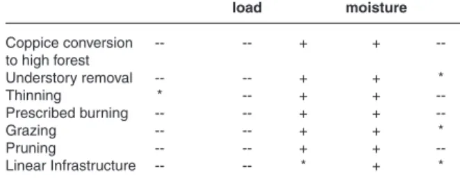
Unfortunately, there is no one-size-fits-all for fuel treatments: thus, managers must consider many factors when implementing a fire smart forest landscape management plan (Vaillant at al. 2009), along with the relevant effect of some environmental factors (Table 1).
Table 1 - The immediate-term effects of fuel treatments on factors
that affect crowning (from Scott 1998 modified and integrated).
Fuel treatment Surface fuel Dead fuel CBH Wind speed CBD load moisture Coppice conversion -- -- + + --to high forest Understory removal -- -- + + * Thinning * -- + + --Prescribed burning -- -- + + --Grazing -- -- + + * Pruning -- -- + + --Linear Infrastructure -- -- * + * : + increase,- - decrease; * no effect
Thinning practices for the management of
forest fuels
Thinning, together with prescribed burning, play the most important role in the silvicultural preven-tion of wildfires. Basically, thinning is effective in reducing both ladder fuels and crown density (Chia-nucci and Cutini 2013), while prescribed burning is effective in reducing surface fuels (Agee and Skin-ner 2005). The decrease in stocking after thinning
Annals of Silvicultural Research - 39 (1), 2015: 1-22
reduces competition for resources in the remaining trees, leading to stands with fewer but larger trees, with thicker bark (Leone and Lovreglio 2005), which are therefore more resistant to running fires and able to intercept more light and to use more water and nutrients (Cantore and Iovino 1989, Reich et al. 2006). The increased light, nutrient and water avail-ability enhances tree growth as a result of improved resource-use efficiency and reduced drought stress (Bréda et al. 1995), which is a critical fire-risk in Mediterranean areas, mainly because of summer drought. The higher water availability also reduces the lower heating value of woody debris due to in-creased fuel moisture content (Dimitrakopoulos and Papaioannou 2001). According to Giordano (1981), the heating value of conifers is on average 18.84 MJ kg-1 when the moisture content is 5%, but it decreases
to 15.28 MJ kg-1 (-19%) when the moisture content
is 30%, reaching a minimum of 9.84 MJ kg-1 (-48%)
when the moisture content is 100%. The biomass removal after thinning subtracts thermal energy, so decreasing the flammability and fire intensity potential, according to the equation:
where Ecal is the thermal energy (kJ m-2), Babv is
the aboveground biomass (kg m-2) and HCV is the
higher calorific value (kJ kg-1).
Similarly, the quantity of water theoretically re-quired for fire suppression (AH2O) can be estimated as
where β is the efficiency coefficient, defined as the ratio between the quantity of water used for sup-pression over the total quantity of water provided and ∆hw is the latent heat of evaporation at 100° C (2.440 kJ kg-1). Based on these simple equations,
Garfì et al (2014) assumed that in a typical chestnut coppice the average reduction has been quantified as 48,505 kJ m-2 after an early thinning (4 years
after coppicing), which represents 71% of the total energy potentially produced by burnable fuel frac-tion, and 44,058 kJ m-2 after an intermediate thinning
(10 years after coppicing), which represent 27% of the total energy potentially produced by burnable fuel fraction. Such a reduction in thermal energy implies a theoretical reduction in suppression cost by decreasing the quantity of water required in fire suppression: -49 kg m-2 after early thinning and -45
kg m-2 after intermediate thinning. Similar values can
be obtained from thinning conifer plantations aged
between 20-50 years old (Garfì et al. 2014).
Thinning is defined by type, intensity, cycle and targeted final desired structure. Thinning type af-fects vertical fuel continuity and crown fire poten-tial. It includes low (thinning from below), crown (thinning from above) and selective thinning. All the three types reduce average canopy bulk density but their influence on canopy structure differ; for example, low thinning increases the canopy base height, while crown and selective thinning do not (Agee and Skinner 2005). Thinning intensity affects directly the horizontal fuel continuity and indirectly the flammability potential (e.g., by increasing soil water content after tree removal; Compostella and Iovino 2009). Thinning cycle refers to the age of first intervention and the interval between repeated interventions. Early start of thinning is particularly important for stand subject to high wind and fire risk like conifers and very dense stands (e.g., cop-pices). The early intervention is recommended as younger trees react more promptly to release from competition, therefore allowing the achievement of more stable stand conditions (Cutini et al. 2009). Conversely, late start of thinning will yield a pro-longed competition between trees, with resulting higher self-pruning (broadleaves) and lower branch size (conifers). Such option is often considered to reduce felling cost while increasing the economic revenues (larger trees are harvested). The desired distribution of trees is another important issue when performing thinning treatments. A uniform distribu-tion is generally required in situadistribu-tions where timber production represents the priority of the manage-ment; however, this assumption may not be valid for forest fires-prevention strategy. There is evidence that a higher diversity in forest ecosystems entails a higher capacity of reducing the spread of disturb-ing agents, includdisturb-ing wildfire (Nocentini and Coll 2013): for example, variable density thinning can be effective to diversify the structure of a stand by creating a diverse range of light environments (Chia-nucci and Cutini 2013, Gómez-Aparicio et al. 2009, González-Moreno et al. 2011), with consequences on the medium-long run on recruitment, establishment and ecophysiological behaviour of natural regenera-tion (Cutini et al. 2009); such opregenera-tion therefore should be strongly recommended in artificial plantations to progressively “re-naturalise” these forest types in order to achieve their self-organizing capacity to respond to natural disturbances, including resist-ance and resilience to fires.
Specific attention should be given to the treat-ment of coppice woods, a silvicultural system which is largely widespread in Mediterranean countries, where it covers an area of about 23 million of hec-tares (UN/ECE-FAO, 2000).
Annals of Silvicultural Research - 39 (1), 2015: 1-22
According to the Italian National Forest Inven-tory, about 42% of the total forested area consists of coppices (www.infc.it), the prevalent species being oak (either deciduous or evergreen oak), hornbeam, chestnut and beech. The key prerequisite for coppice management is the sprouting ability of coppiced tree species, which has been interpreted as a fire-tolerance strategy, i.e. a plant adaptation in ecosystem characterized by frequent crown fire occurrences, as commonly observed in Mediter-ranean areas (Bond and van Wilgen 1996). This fire-tolerance strategy allows plants to withstand a degree of burning and continue growing despite fire damage, making stand recovery in the coppice system more likely than in other forest types; for example, Providoli et al. (2002) demonstrated that coppicing chestnut stands immediately after fire promotes the rapid recovery of ground vegetation, which in turn reduces the rate of erosion caused by splash transport.
Fuel management and reducing fire-risk in coppice woods is currently a major challenge in Mediterranean countries, where the observed re-cent changes in forest management perspectives, combined with changing socio-economic conditions and the increasing use of non-renewable raw mate-rial have strongly modified the composition and structure of large forest areas previously managed as coppice. These processes resulted in the decline of overall wood exploitation and lengthening of ro-tation period in coppice woods (Cutini et al. 2013). The interruption of the traditional tending opera-tions and active management has led to substantial biomass accumulation in these forest formations, threatening the conservation of the coppice system from a fire-risk perspective. The abandoning of cop-pice leads to a slow natural evolution of the stand towards high forest, but a more active management can foster dynamics and the achievement of more mature stand structures, reducing the risk of fire damage, and still allowing economic revenue from silvicultural interventions (Ciancio et al. 2006). Converting coppice to high forest represents an ef-fective option to improve stand conditions and for preventing fire-risk in these forest formations. Vari-ous studies have demonstrated that applying low, moderate thinning decreases fire intensity, as they combine relatively low production of dead organic material and good decomposition conditions for it (Zagas et al. 1998, Zagas et al. 2004). It was also previ-ously outlined that low thinning is more suitable for fire prevention than crown and selective thinning, as they are more effective in reducing canopy base height and canopy bulk density (Agee and Skinner 2005, Leone and Lovreglio 2005).
Some potential concerns related to thinning
have to be considered in planning fire prevention treatments. In particular, thinning may increase fire damages and tree mortality (Raymond and Peterson 2005) because of:
- an open understory, that allows surface wind to increase and surface fuels to become drier, and thus may increase fire intensity and rate of spread;
- additional fine wood left from the thinning op-eration (even when the whole-tree system is applied) and grass and shrubs re-growth most likely cause higher surface fireline intensity, thus contributing to severe scorch of overstory trees.
Fuel treatments intended to minimize tree mortality will be most effective if both ladder and surface fuels are treated, i.e. thinning followed by underburning (prescribed burn) (Pollet and Omi 2002, Stephens and Moghaddas 2005, Agee and Lolley 2006).
Mechanical operations for forest-fires
prevention
Mechanical treatments have the potential to recover product value so that treatment costs are partially offset. As mentioned, thinning allows con-trolling species selection, fuel ladders and canopy density; however, thinning can be problematic when: (i) the value of removed wood does not offset treat-ment costs; (ii) slash significantly increases surface fuel loads (McIver and Ottmar 2007); (iii) activities are limited by road access, slope steepness, or sensitive soils. The effectiveness of mechanical-only treatments depends on how much surface fuel remains.
While there are several approaches to treat criti-cal surface fuels, a key constrain is the high costs of the interventions. Cutting, processing and hauling large numbers of small-volume pieces is costly and every additional operation further increases the costs (Rummer 2004). This is a particularly crucial issue in situations where a market for biomass prod-ucts does not exist, while the increasing importance of forest biomass for energy uses (Berndes et al. 2003) may help in reducing the costs of silvicultural treatments.
Three harvesting methods are commonly used in forest operation: cut-to-length system (CTL); tree length system (TLS); whole-tree harvesting (WTH) (Fight et al.1999, Hartsough et al. 1998, Windell and Bradshaw 2000). Removing the limbs and tops of trees and cutting them into merchantable lengths can occur in the forest or at the landing. In CTL, trees are felled and processed at the stump before being extracted to a landing (Spinelli et al. 2010a). In TLS, trees are felled, delimbed and topped at the stump before being extracted to a landing (Rushton
Annals of Silvicultural Research - 39 (1), 2015: 1-22
et al. 2003). In WTH, trees are felled and immediately removed to a landing where they are processed, thereby reducing potential fire severity more than methods which leave slash within the stand (Hart-sough et al. 2008, Marchi et al. 2014, Picchio et al. 2012a). Slash left on ground and deposition of ad-ditional fine- to medium-sized surface fuels signifi-cantly increase flame length and torching potential (Agee and Skinner 2005).
Biomass bundling is an alternative that allows recovery of forest residues for potential utilization when CTL or TLS are applied (Rummer 2004). How-ever, a complete removal of logging residues can negatively affect post-logging soil erosion (Rice and Datzman 1981, Edeso et al. 1999) and soil fertility (Zabowski et al. 1994), and thus tree growth (Egnell and Valinger, 2003, Ampoorter et al. 2007).
In forest thinning, the main operations are fell-ing, processfell-ing, bunching and extraction. Felling and processing can be efficiently carried out by chainsaw (Arno and Fiedler 2005, Stephens and Moghaddas 2005). Chainsaw felling requires a lim-ited capital investment and can be applied in areas where modern forest machinery (harvester and feller) cannot work. However, chainsaw felling is more dangerous for the workers, because they are exposed to numerous risks (Montorselli et al. 2010). Modern machinery like harvester and feller provides greater comfort and safety for workers (Bell 2002). The use of harvester and feller increases productiv-ity and reduces the costs of forest operation, when compared with motor-manual (chainsaw) felling and processing (Wang et al. 1998) (Table 2).
Ground slope and roughness are the main limit-ing conditions for uslimit-ing these modern machineries (Stampfer 1999). The optimal operating range of mechanized felling and processing is on terrain with a maximum slope of 40%, in areas with high acces-sibility and where roads and forest tracks are well developed (Spinelli et al. 2008).
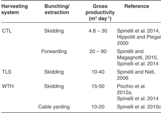
In thinning, wood bunching and extraction can
Table 2 - Productivity in felling and processing in forest thinning
when cut-to-length (CTL), tree length (TLS), or whole-tree harvesting (WTH) systems are applied.
Harvesting Felling/ Gross Reference
system processing method productivity
(m3 day-1)
CTL Chainsaw 2.4 – 18 Balimunsi et al. 2012
Harvester 25 – 40 Spinelli and Stampfer 2002
TLS Chainsaw 16-18 Baldini and
Picchio 2001
WTH Chainsaw 24-64 Marchi et al., 2012
Feller/harvester 40 – 80 Spinelli and
Nati, 2006; Bergström et al., 2010
be carried out mainly by skidding, forwarding or cable yarding, with different performances in terms of productivity (Table 3). In thinning, the most af-fordable extraction system is by skidder with winch, due to low effective cost and flexibility. Tradition-ally, the winch cable is used in bunching logs or trees to skid trail (winching), so that only a limited portion of topsoil of the area is damaged by skid-der trafficking (Ampoorter et al. 2012). On slightly sloping terrains, however, skidder with grapple can be used. The hydraulic grapple is operated by the skidder driver, and grabs bundles or logs without requiring further workers (Hunter et al. 2007). In order to maximize the performances of skidding systems, a strategically-planned network of forest trails is necessary to ensure good productivity and minimize the impact on forest soil (Picchio et al. 2011, 2012a, 2012b).
Extraction by forwarder or by tractor and trailer is normally not recommended in the first thinning and in the selective thinning due to the considerable size and weight of these machines, while this extrac-tion method may be applied in geometric or mixed thinning. In the last few years, mini-forwarders have been made available, with size and weight suited for their use in thinning (Spinelli et al. 2010c). In cable yarding, trees are removed via a skyline cable system and can be processed at the stump or at the landing. Cable yarding is generally applied in steep slopes, where the use of ground-based forest equipment is restricted. This extraction system has high direct cost, due to the time for assembling and disassem-bling the lines. Only simple cable yarder can be used in thinning when a small wood volume has to be extracted (Neri and Piegai 2007a). In WTH, trees are processed at the landing by using a processor, and the residues are usually chipped for biomass production (Neri and Piegai 2007a, 2007b).
Thinning is sometimes not effective in increasing canopy-base height, unless smaller trees and lower limbs are removed as well (Hunter et al. 2007). Low
Harvesting Bunching/ Gross Reference
system extraction productivity
(m3 day-1)
CTL Skidding 4.8 – 30 Spinelli et al. 2014,
Hippoliti and Piegai 2000
Forwarding 20 – 90 Spinelli and Magagnotti, 2010, Spinelli et al. 2014
TLS Skidding 10-40 Spinelli and Nati,
2006
WTH Skidding 15-50 Picchio et al.
2012a,
Spinelli et al. 2014
Cable yarding 10-20 Spinelli et al. 2010c
Table 3 - Productivities in bunching-extraction in forest thinning
when cut-to-length (CTL), tree length (TLS), or whole-tree harvesting (WTH) systems are applied.
Annals of Silvicultural Research - 39 (1), 2015: 1-22
pruning is usually carried out with manual (hacksaw, loppers, etc.) or motor-manual systems (chainsaw) on branches with < 10 cm (2-4 cm on average) di-ameter. Pruning is a high labour-intensive and very expensive operation, especially when is not associ-ated with thinning.
Mastication is another mechanical treatment that can be used to reduce fuels in the stand. Small standing trees can be processed using masticators, which grind trees to the stump and disperse the resulting small material on the ground. Mastication is an increasingly common fuel treatment that redis-tributes ‘‘ladder’’ fuel to the forest floor in order to reduce vertical fuel continuity, crown fire potential, and fireline intensity (Kane et al. 2009, Vitorelo et al. 2009, Kreye et al. 2014). Mastication can be used as a stand-alone treatment (Battaglia et al. 2010, Reiner et al. 2009), but may also be applied following understory thinning (Kane et al. 2009), or prior to prescribed burning (Knapp et al. 2011, Kreye et al. 2013). Masticated debris has a propensity to flame and smolder for long durations; however, improved knowledge to elucidate fire behavior and effects in these treatments is still required (Kreye et al. 2014). Fire burning in masticated fuels behaves in unexpected and contradictory ways, likely because the shredded, compact fuel created when trees and shrubs are masticated contains irregularly shaped pieces in mixtures that are quite different from other woody fuels.
In mechanical treatments for fuel management, the methodologies of felling, processing and ex-traction have to be planned on a large spatial and temporal scale. They cannot be localized events, and must be framed into the socio-economical and environmental context. Forest operations have to be planned during implementation and execution of the work phases. Therefore they require a schedule
Table 4 - CO2 emission and energetic input for some forest yards (Heinimann 2012, modified).
Reference CO2 emission Energy input
(kg m-3) (MJ m-3) Ecoinvent 20121 12.4 165 ProBas 20121 17.9 50 Magagnotti e Spinelli, 20112 - 100-200 Magagnotti e Spinelli, 20113 - 9-20 Picchio et al., 20092,4 - 700-900 Gonzàles-Garcìa et al. 20095 28-33 175-279 Valente et al. 20115 4-6 162 Magagnotti e Spinelli, 20116 - 60-150 Picchio et al., 2012c4,7 - 850
1With forest road maintenance; 2With loading on truck; 3 Bunching-Extraction by horses; 4Gross energy requirement methodology; 5With transport enclosed; 6Skidding; 7Chips production
Figure 2 - Energetic input (a) and CO2 emissions (b) calculated from data measured from two experimental thinning yards (thinning, ± range) and estimated for two levels of fire suppression activity assuming that thinning was not carried out (low and high suppression ef-forts).
of forest works that integrates all activities of previ-sion and preparation of infrastructure and resources needed for their proper execution.
An important aspect to be considered in forest operation planning is the impact on the environ-ment, especially on soil and residual trees. During forest operation, the area affected by soil distur-bance (compaction, rutting, soil mixing and dis-placement) may range between 10 and 70% of the total logged stand and the impact on the ecosystem can be substantial (Picchio et al. 2012b). A range of 4–21% of damaged residual trees has been recorded for thinning in conifer and mixed stands (Picchio et al. 2011, Spinelli et al. 2010b, Vasiliauskas 2001). Other impacts, such as the energy input or CO2 emissions, should be assessed when planning fire prevention thinning (Table 4). As an example, we compare the values recorded for two thinning yards in conifer stands in Italy (Figure 2– unpublished data), with the values calculated for two levels of suppression activity (low and high) in the same un-thinned areas. The results highlight the importance of thinning as fuel treatment, also because the CO2 emissions caused directly by fire are not included.
Annals of Silvicultural Research - 39 (1), 2015: 1-22
Prescribed burning
Prescribed burning is one of the most common and effective fuel management techniques for fire hazard reduction (Fernandes and Botelho 2003, Boer et al. 2009, Rego et al. 2010, McIver et al. 2013). It is applied to maintain strategic fuel breaks (Fernandes et al. 2013) and buffer zones at the wildland-urban interface (Keeley 2002, Ryan et al. 2013), or for area wide fuel treatments in fire-prone landscapes (Russel-Smith et al. 2013, Ryan et al. 2013, van Wil-gen 2013).
In forested areas, low intensity burns (i.e., be-tween 50 and 700 kW m-1), are generally carried out
over treatment units of variable size, i.e., 10 - 1000 hectares (Hartsough et al. 2008, Boer et al. 2009, Fernandes et al. 2013) to reduce the load of surface fuels (upper litter, fine dead wood, grasses and low shrubs); these burns may also increase the distance between the base of the tree canopy and understory fuels (McIver et al. 2013) by scorching lower branch-es of trebranch-es, consuming ladder fuels (e.g., epiphytic vegetation), and by thinning elevated shrubs and young trees (Figure 3). In savannas, grasslands and shrublands, prescribed burning is generally planned over larger units in comparison to forested areas (Higgins et al. 2011, Russell-Smith et al. 2013, van Wilgen 2013), to consume accumulated dead mate-rial and remove shrub canopy fuels; in these cases, moderate to relatively intense burns (above 1000 kW m-1) are needed to allow crown fire sustainment
(Keeley 2002, Castagneri et al. 2013). Prescribed burning is often used in combination with other fuel management techniques such as mastication, thinning, herbicide and grazing (e.g., Kobziar et al. 2009). Mechanical treatment followed by prescribed burning is considered the most effective in reducing stand flammability (McIver et al. 2013).
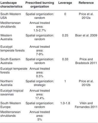
The popularity of prescribed burning for fire hazard abatement is due to several aspects. Many studies have demonstrated its effectiveness in re-ducing the fuel complex flammability for several years after treatment, and in mitigating wildfire behaviour and severity at the stand and landscape scale (e.g., Fernandes and Botelho 2003, Finney et al. 2005, Boer et al. 2009, Kobziar et al. 2009, McIver et al. 2013). However, the “leverage” of prescribed burning (the decrease in wildfire area per unit area of prescribed burning) is highly variable (Table 5), depending on the environmental and social aspects which characterize the fire regime of the considered area, the extent, spatial organization and connectiv-ity of treatment units, and the landscape character-istics (Boer et al. 2009, Price et al. 2012a, Fernandes et al. 2013). Prescribed burning leverage is higher in Mediterranean countries of Europe where can
reach values >1 (prescribed burning decreases the total area burned) (Vilén and Fernandes 2011, Price et al. 2015). In France, Portugal and Spain this technique has been adopted since the ‘80s of the XX century (Fernandes et al. 2013), and recently it has been experimented also in some Italian regions (As-coli and Bovio 2013). In these countries, prescribed burning is implemented in strategic areas relatively small in size along major pathways of recurrent an-thropogenic fires with predictable spread patterns (Castellnou et al. 2010, Fernandes 2013). In addition, in several regions it has been successfully used to as-sist grazing management and replace the clandestine use of fire by shepherds in high fire danger periods (Coughlan 2014, Fernandes et al. 2013). The above mentioned aspects, together with a fragmented landscape, and a milder fire weather in comparison to other geographical areas (Vilén and Fernandes 2011), contribute to increase prescribed burning leverage in Southern Europe (Fernandes et al. 2013). However, also in areas where prescribed burning programs have a leverage < 1 (prescribed burning increases the total area burned) (Price and Brad-stock 2011, Price et al. 2012b), several other benefits are expected in treated areas, such as a higher fire suppression capacity (Fernandes and Botelho 2003), wildfire emissions abatement (Russell-Smith et al. 2013), and more resilient landscapes (Fernandes and Botelho 2003, Boer et al. 2009, Ryan et al. 2013).
One of the main reasons which makes this tech-nique so popular in some countries is that prescribed burning may attain multiple land management goals at the same time, such as ecosystem restoration, increased livestock production, fire-fighters training (Ryan et al. 2013), and can help to solve social con-flicts related to traditional fire uses (Fernandes et al. 2013, Valese et al. 2014). In particular, historical fire regime restoration to maintain ecosystem health is a complementary target of most prescribed burning programs for fire hazard reduction (Boer et al. 2009, Russell-Smith et al. 2013, Ryan et al. 2013). Fire has played an important role in shaping many biomes worldwide (Bond and van Wilgen 1996, Pausas and Keely 2009). Consequently, prescribed burning has been the most attractive fuel-reduction practice, for the reason that it is most likely to emulate the natural process that it is designed to replace. This is particu-larly true in Americas, Australia and South Africa, where colonization by Europeans was a discrete event which produced major changes in historical fire regimes (Pyne 1997). In these geographical areas the target of prescribed burning programs in most cases is to mimic pre-settlement fire regimes as they are considered necessary to ecosystems health (Russell-Smith et al. 2013, Ryan et al. 2013, van Wilgen 2013).
Annals of Silvicultural Research - 39 (1), 2015: 1-22
Last, but not least, the financial costs of pre-scribed burning can be very competitive if compared to other fuel management techniques (Hesseln 2000), depending on the extent of the area treated, and on environmental (e.g., vegetation type, avail-able weather windows) and operative (e.g., training level of fire personnel) aspects. In a comparative study of different fuel treatments throughout west-ern USA, Hartsough et al. (2008) found that the gross costs of prescribed burning were the lowest, but the net costs of mechanical treatments after deducting the values of harvested products were less than those of fire. However, a comprehensive analysis of the economics of prescribed burning must take into account social costs, such as potential damage from escape, air quality, safety issues, and aesthet-ics (Hesseln 2000), and long term benefits, such as reduced fire control costs, wildfire carbon emission abatement (Vilén and Fernandes 2011, Russel-Smith et al. 2013), and nature conservation (Hartsough et al. 2008).
Despite its popularity, prescribed burning contin-ues to face numerous social–ecological challenges in every geographical area it has been applied (Keeley 2002, Boer et al. 2009, Fernandes et al. 2013). Major impediments are economics, air quality concerns and environmental laws, risk of liability for escaped fires, high costs or lack of insurance availability, lack of adequate personnel and risk-averse poli-cies (e.g., Quinn-Davidson and Varner 2012, Ascoli and Bovio 2013). Several ecological concerns exist; prescriptions reducing fire hazard may not always enhance resource values and sometimes may have a detrimental effect (Keeley 2002, Ryan et al. 2013). The combination of fire with mechanical or grazing treatments may increase the spread of exotic plant species (Lonati et al. 2009, McIver et al. 2013).
Given the complexity in assessing the cost-effectiveness of prescribed burning and its long-term implications on ecosystem services, several plan-ning tools have been developed to assist prescribed burning (e.g., Higgins et al. 2011, Fernandes et al. 2012, Ager et al. 2013). Technology has expanded
Figure 3 - Short term (6 months) effects on understory fuel load and structure of prescribed burning (left side) compared to an untreated
con-trol area (right side). The burn was carried out in winter in Central Italy in a Pinus pinaster stand.
the ability to plan prescribed burning. However, to minimize undesired effects and maximize prescribed burning benefits it is necessary an understanding of ecosystem services trade-offs and an evidence-based adaptive approach, applied with scientific rigor and management practicality (Ascoli et al. 2009, Fer-nandes et al. 2013, Ryan et al. 2013, van Wilgen 2013).
Fuel management in the wildland-urban
interface
Fuel management to reduce fire-risk is one of the most crucial issues in densely populated areas adjacent to forested landscapes. These areas, called wildland-urban interfaces (WUIs), have recently re-ceived considerable attention because of increases in both the number of structures destroyed and
Table 5 - Prescribed burning leverage in landscapes with different
characteristics. Where leverage >1, prescribed burning treatment leads to a reduction in the total area burnt (by prescribed and wildfires); where leverage <1, treatment increases the total burnt area.
Landscape Prescribed burning Leverage Reference
characteristics organization
South Western Spatial organization: 0 Price et al.
USA random 2012a
Mediterranean Annual treated shrublands area:
1.5-2.7%
Western Spatial organization: 0.25 Boer et al. 2009 Australia random
Eucalypt Annual treated
temperate forests area:
7-9% South Eastern Spatial organization: 0.33 Price and
Australia random Bradstock 2011
Eucalypt temperate Annual treated forests area:
0.5% Northern Spatial organization: 1 Price et al.
Australia strategic 2012b
Eucalypt tropical Annual treated savannas area:
17.4% South Western Spatial organization: 1.0-1.8 Vilén and
Europe random Fernandes 2011
Mediterranean Annual treated shrublands area:
Annals of Silvicultural Research - 39 (1), 2015: 1-22
the peri-urban area burned annually by wildfire (Radeloff et al. 2005, Moreira et al. 2011). For this reason, WUIs are a significant issue in terms of fire-risk management (Cohen 2010), and it becomes rel-evant to identify effective fuel management in WUIs that respond to the needs of society (i.e., to protect structures and human settlements and ensure the efficiency of forest ecosystem) (Elia et al. 2012).
According to Stewart et al. (2007), the term “wildland-urban interface” is almost exclusively used in the context of wildland fire. However, there are different definitions for this term. A wildland-urban interface is an area where houses meet - or intermingle with - undeveloped wildland vegetation (Radeloff et al. 2005, Theobald and Romme 2007). When urban areas are interspersed with forests, wildfire threat to human well-being arises at the in-terfaces where anthropogenic development merges with wildland areas (Gill and Stephens 2009).
The interconnection space between housing facilities and vegetation is always very tight, yet considerably different from case-to-case. In this regard, numerous studies have analyzed and ex-plored WUI growth dynamics in different countries worldwide (Kaplan e Austin 2004, Radeloff et al. 2005, Nowak e Walton 2005, Zhang e Yang 2008, Lein e Stump 2009). In the United States, the Federal Register (2001) classifies WUIs into three categories:
intermix where the houses are mixed with dense
vegetation (trees and shrubs), interface where the houses bordering vegetation fuel are separated by a defined demarcation line, and occluded where “islands” of wildland vegetation are present inside a largely urbanized area (Table 6).
Radeloff et al. (2005) estimated that in 2000 the WUIs in the United States covered a surface of 719,216 km2 and included approximately 39% of all residential units of the continental United States. Nowak and Walton (2005) have forecasted an increase of urban sprawl from 3.1% to 8.1% by the year 2050. Zhang and Yang (2008) have conducted a research in southeastern United States from 1990 to 2000 and have observed the number of patches
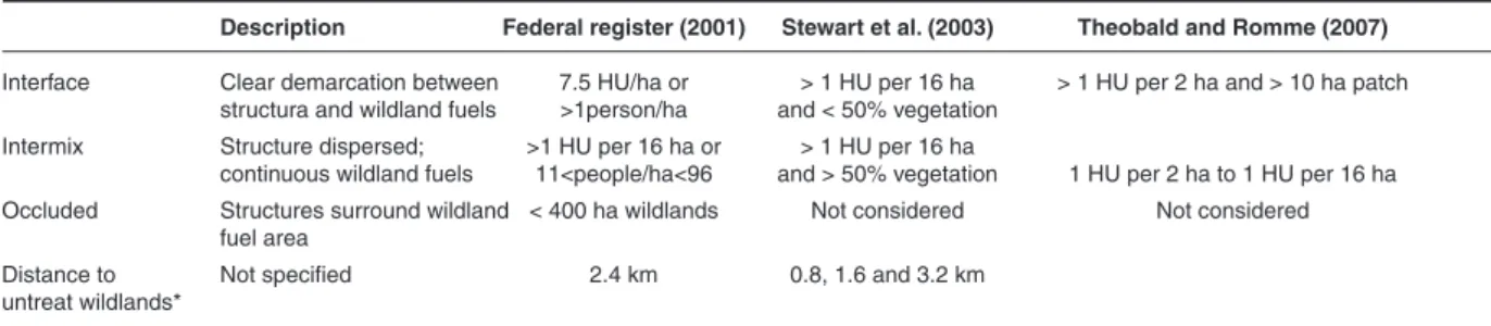
Table 6 - Definition of interface, intermix, and occluded WUIs and resulting areas from the Federal Register (2001), Stewart et al. (2007), and
Theobald and Romme (2007). HU, housing units
Description Federal register (2001) Stewart et al. (2003) Theobald and Romme (2007)
Interface Clear demarcation between 7.5 HU/ha or > 1 HU per 16 ha > 1 HU per 2 ha and > 10 ha patch structura and wildland fuels >1person/ha and < 50% vegetation
Intermix Structure dispersed; >1 HU per 16 ha or > 1 HU per 16 ha
continuous wildland fuels 11<people/ha<96 and > 50% vegetation 1 HU per 2 ha to 1 HU per 16 ha Occluded Structures surround wildland < 400 ha wildlands Not considered Not considered
fuel area
Distance to Not specified 2.4 km 0.8, 1.6 and 3.2 km
untreat wildlands*
*Untreated wildlands are areas where no fuel treatments have been carried out to mitigate wildland fire-risk in the WUI community
decreased from 1,362 to 1,282 despite a 65% increase in the mean size of WUIs; this suggests that most WUIs merged forming larger patches with average surface increases from 178 km2 (1990) to 233 km2 (2000). This growth was partially explained by the gradual demographic flows of the population from urban to rural areas (Kaplan and Austin 2004). Population displacement in rural areas has led to the rapid development of peri-urban fringes, which have become an environmentally and culturally relevant local resource (Lein and Stump 2009).
In Europe, especially in the Mediterranean Basin, the urbanization issue has resulted in the expansion of size and number of WUIs. During the last few decades, the constant transformation of peri-urban areas, agricultural land abandonment and “re-naturalization” have led to substantial biomass accumulation in a context of uncontrolled residential growth (Badia et al. 2011). WUIs create an environment in which fire can easily spread from forest fuels to human settlements (Bowman et al. 2009). Therefore, it becomes essential to manage wildland areas close to human developments and, in particular, to create a “defensible space” between buildings and adjacent vegetation (Bovio et al. 2002, Lovreglio et al. 2010). This space is an area where fire can spread from houses to vegetation and vice-versa. Fuel accumulation, the improper use of fire to eliminate waste and harmful animals, and inaccurate fuel management are a few of the many factors caus-ing wildfires in defensible space.
The WUIs are complex areas characterized by a mixture of man-made and vegetation structures and sizes (Stewart et al. 2007). In these contexts human activities are in close contact with forest fuels, resulting mostly in ignition points for potential wildfires. The delineation of WUIs by appropriate maps, at different scales, becomes an essential knowledge-base for landscape planning and fuel managing (Spyratos et al. 2007, Syphard et al. 2007).
Many studies have investigated landscape plan-ning and fuel management in WUI using Geographic Information Systems (GIS) to process remotely
Annals of Silvicultural Research - 39 (1), 2015: 1-22
sensed images and lidar data (Zhu and Hejmanow-ska, 2013). Several authors (Caballero et al. 2007, Dumas et al. 2008, Lein and Stump 2009, Lampin-Maillet et al. 2010, Badia et al. 2011) have described and classified WUIs for wildfires prevention, begin-ning with the assumption that fire-risk is a function of variables related to man-made activities and the presence/absence of fuel. In particular, these studies consider two categories of variables: biophysical and human. Among biophysical variables are vegeta-tion (fuel) types and their structural attributes (e.g., height, age of the population, diameter at breast height, etc.), topographic features (e.g., altitude, slope, aspect) and climate.
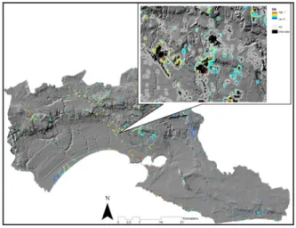
A study on the mapping of fire-risk in WUIs conducted by Lein and Stump (2009) led to the de-sign of an ignition points map in WUIs (Ohio, U.S.) using two types of criteria: environmental, strictly related to fuel flammability, and human, related to ignition (fuel accessibility, proximity to transport infrastructures, population density, etc.). Lampin-Maillet et al. (2010) developed a method for mapping WUIs in the south of France. This method is based on the combination of four spatial classes of urban density (isolated, scattered uniformly, scattered in groups, dense) and three categories of presence/ absence of vegetation (low, medium, high). Through a spatial analysis, the map of the 12 WUI types has been then intersected with the map of ignition points and the distribution of burnt areas. Badia et al. (2011) identified a method for determining the likely ignition points in two WUI areas located in Catalonia (northeast Spain); This study integrated multivariate regression analysis, to identify the most significant biophysical and anthropogenic variables affecting wildfire-risk, and the spatial analysis of these variables using data acquired from remote sensing images. Elia et al. (2014) developed a Spa-tial Allocation Index to determine where and what type of WUI areas may be eligible for fuel removal in southern Italy (Figure 4). The Authors integrated ecological and social factors as a product of natural (i.e., fuel load) and human system (i.e., population, housing, and roads).
The main goals of this research were to iden-tify WUI landscapes in which fires may occur, the points with the highest probability of ignition, and the critical factors causing major events (Amatulli et al. 2007, Romero-Calcerrada and Novillo 2008). After identifying the most critical areas, the best method for reducing risk is to alter the fuel in terms of loadings and stand structure (Shang et al. 2004, Hessburg et al. 2007, Schmidt et al. 2008, Ager et al. 2010, Elia et al. 2014). Much effort has been spent on changing the conditions of WUI fuels through fuel treatments (Conard et al. 2001, Gärtner et al. 2008).
Physics-based models can provide fire behaviour predictions over a broad range of wildland and residential fuel types under a variety of climate and topography conditions. Various models that include sufficient experimental and field measure-ments could be used to support forest policy-making and fire resource management for WUI fuels and environmental conditions (Thompson et al. 2011, Scott et al. 2013, Lafortezza et al. 2013). Although such a program, especially one with large-scale field measurements, would be expensive, the cost of not undertaking it in the long run would be even higher (Whitman et al. 2013).
Forest management planning and fire
pre-vention planning
Fire prevention involves the active management of woodlands while land abandonment promotes the spread of wildfires. Among the tools that foster active forest management, planning is a leading one in order to program and coordinate actions in a given territory. Forest planning can be implemented at various spatial scales; they will be briefly mentioned here, with reference to the Italian context, defining the specific contribution of each of them to fire prevention. Effective land planning needs spatial data and among these fire-risk maps are an indis-pensable tool to fulfill the fire damage prevention and mitigation objectives. The main characteristics of this important information layer will be outlined in the second part of this paragraph.
Large-scale forest plans in Italy, namely the Regional Forest Plans (RFP), are effective tool for strategic programming in the forest sector. They take into account the multifunctional role of forests and respond to the policy objectives established at national as well as international level. Elements of
Figure 4 - Map of the Spatial Allocation Index (Elia et al. 2014) by
combining 1-hour fuel load, urban density, road density, and population density. The index reveales where and what type of forest areas may be eligible for fuel removal across the WUI interface.
Annals of Silvicultural Research - 39 (1), 2015: 1-22
reference in their preparation are the criteria for sustainable management. In all the Italian admin-istrative regions, RFRs contain directions to foster silvicultural treatments with experimented posi-tive effects in terms of fire prevention, particularly pre-commercial thinning, thinning and pruning. Additional rules concern planning, building and maintenance of infrastructures, such as roads, skid tracks or bridges, which are important to allow for allowing a more effective forest access for vehicles and people committed to extinguish fires.
A more operational role is given to the Regional Plan Against Forest Fires (RPAFF), specifically dedicated to forecast, prevent and fighting wildfires, which is mandatory for each administrative Region. Starting from the classification and mapping of the territory of each Municipality according to the risk of fire, the plan sets out the actions needed to make fire fighting more timely and effective, also by public participation.
At a territorial scale level intermediate between the RFP plan and management plans for single forest estates, there is the Forest Landscape Plan (FLP), which generally covers forested areas between 50 and 150 thousands of hectares in homogeneous landscapes coinciding with administrative units (e.g., large protected areas, mountain Communities) and comprising both public and private forests. The objectives of this type of plan are: i) defining management guidelines for different parts of the woodland based on the predominant functions to orient forest planning at lower hierarchical level (management plan for single forest ownership); ii) establishing priorities of action also for the purposes of allocation of public funds; iii) promoting syner-gies and solving conflicts between forest functions also through the participation of stakeholders in decision-making.
FLP incorporates the constraints and rules on the use of forest deriving from higher hierarchical levels of land planning (e.g. regional urban plans, watershed management plans, national park plan-ning). Among the various layers of information to be considered by FLPs, wildfire-risk maps have a special relevance. Maps included in RPAFFs can be transformed at a larger scale detail (1:10,000) if spatially distributed information on local climate, topography, forest types, live and dead biomass, roads, are readily available. Risk of fire is one of the elements to be evaluated in order to decide the priority of implementing silvicultural treatments and building infrastructure to prevent or mitigate the damage of fires. The degree of risk must be corre-lated to the importance of the functions assigned to the different parts of the wooded area. The attention will concentrate in areas where high fire-risk affects
stands with functions of greater social (protection forests), naturalistic (e.g., priority habitats of the Natura 2000 network) and economic (stands with high stumpage prices) values.
At the lowest hierarchical level of forest planning is the management plan for a single forest estate. It regulates in time and space the application of management prescriptions to forest stands during a period of time which usually does not exceed 10-15 years. Traditional goal of the plan is the optimiza-tion of timber producoptimiza-tion and the income of the owner. Currently, the plan is being conceived as a more flexible and articulated tool than in the past as forest management is increasingly multifunctional and must confront the challenges posed to forest ecosystems by global change. For the purpose of fire prevention, directions of RFP and FLP on silvi-cultural treatments, their priority and urgency are translated into an action program detailing the type and intensity of interventions based on site condi-tions and stand structure.
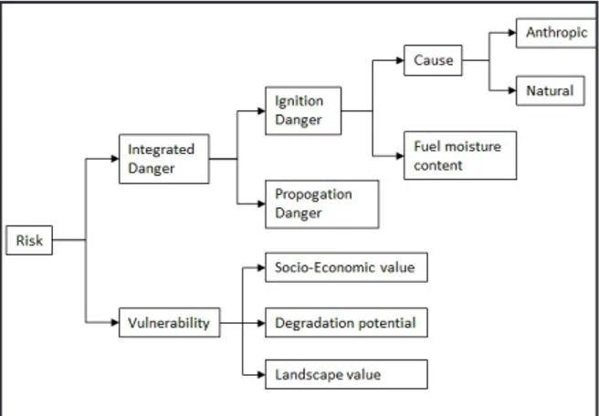
At various spatial scale levels the knowledge of the potential level of fire-risk, in term of magnitude and distribution in the territory, is essential to ensure appropriate fire prevention planning (Bar-Massada et al. 2009). From a methodological point of view, the analysis of risk assessment may differ accord-ing to the type of data used and for the detail of cartographic output. In particular, it can be carried out based either only on historical data or on the assessment of predisposing and determinant factors. The analysis of historical data regards the statistics of the fires occurred in the past. Instead, the analysis of predisposing factors requires the morphological, climatic and vegetation characterization, together with the human and natural characterization, for the determinant factors analysis. From a morpho-logical point of view, the different combinations of altitude and aspect, in relation to the slopes, define a different probability of front flame propagation, as well as the climatic characteristics. The different vegetation types may give rise to different kind of fuel loads and spatial distribution and, therefore, to different probability of propagation. Finally the anthropic factor is the main determining factor for a fire ignition (Finney 2005, Hardy 2005).
The vulnerability assessment evaluates the negative fire effects. These effects could be assessed through the , pre- and post-fire, analysis of the socio-economic values (e.g., properties, wood resources, recreational importance, carbon stocks), degrada-tion potential (i.e., soil and vegetadegrada-tion condidegrada-tions), and landscape value (e.g., uniqueness, conservation status (Hardy 2005, Chuvieco et al. 2010). An exam-ple of framework for fire-risk assessment, which includes the aspects mentioned above, is shown