The August 24
th
2016 Accumoli
earthquake: surface faulting and
Deep-Seated Gravitational Slope
Deformation (DSGSD) in the Monte
Vettore area
DOMENICO ARINGOLI,PIERO FARABOLLINI, MARCO GIACOPETTI,MARCO MATERAZZI, SILVIA PAGGI,GILBERTO PAMBIANCHI,PIETRO PAOLO PIERANTONI,EUGENIO PISTOLESI,
ALAN PITTS,EMANUELE TONDI [email protected]
Geology Division, School of Sciences and Technology,University of Camerino (Italy)
Abstract
On August 24th 2016 a Mw=6.0 earthquake hit central Italy, with the epicenter located at the boundaries
between Lazio, Marche, Abruzzi and Umbria regions, near the village of Accumoli (Rieti, Lazio). Immedi-ately after the mainshock, this geological survey has been focused on the earthquake environmental effects related to the tectonic reactivation of the previously mapped active fault (i.e. primary), as well as second-ary effects mostly related to the seismic shaking (e.g. landslides and fracturing in soil and rock).This paper brings data on superficial effects and some preliminary considerations about the interaction and possible relationship between surface faulting and the occurrence of Deep-Seated Gravitational Slope Deformation (DSGSD) along the southern and western slope of Monte Vettore.
I.INTRODUCTION
On August 24th 2016 a Mw=6.0 earthquake struck a vast area in central Italy causing many fatalities (297) and lot of damage to houses and infrastructures. The epicentre of the mainshock was located near the village of Accumoli (Rie-ti) and thousands of aftershocks continuing to shake the area since until the end of September 2016, when we are writing this paper (for de-tails about the seismic record of the sequence, please see the reports available on this web site: http://terremoti.ingv.it/it/). The focal
mechanism of the mainshock and the distribu-tion of the aftershocks suggest the activadistribu-tion of a NNW-SSE oriented and WSW dipping nor-mal fault, with a minor left-lateral component of motion.
Immediately after the main event and also in the following days, the geological survey was carried out around the epicentral area and along the previously mapped active faults (Cello et al., 1997: Galadini and Galli, 2000; Tondi and Cello, 2003; Boncio et al., 2004). The focus of the survey was to detect both the
ef-fects related to the reactivation of the active faults (i.e. primary) and the seismic shaking
(e.g. landslides and fracturing in soil and rock), generally classified as secondary effects.
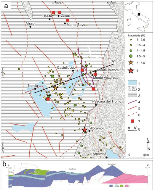
Figure 1 – a) Geological and structural sketch of the study area with location of the main epicenters (updated September 25th 2016 – source INGV): 1) Quaternary continental deposits; 2) mainly arenaceous-pelitic bed-rock; 3) mainly calcareous and marly calcareous bedbed-rock; 4) Monte Vettore fault system; 5) main dip-slip and transverse faults; 6) main thrusts; 7) main DSGSD’s and large landslides; 8) trace of cross-section (see below). b) Schematic cross section: 1) mainly calcareous formations; 2) marly calcareous formations; 3) calcareous and marly calcareous formations; 4) arenaceous-pelitic formations
This paper presents field data of the superficial effects observed in the area of Monte Vettore, where both an active fault and a Deep-Seated Gravitational Slope Deformation (DSGSD) was previously mapped (Cello et al., 1997; Aringoli et al., 2010a; Pierantoni et al., 2012). Moreover, some preliminary considerations about the in-teraction and the possible relationship between the characterized primary and secondary ef-fects are proposed.
II.GEOLOGICAL AND SEISMIC FRAMEWORK The Castelluccio basin is an intramontane de-pression, located in the central Apennines, and filled by Pleistocene to Holocene fluvial-lacustrine deposits; bedrock units are instead represented by limestone and pelagic marls of Jurassic to Miocene age (Figure 1). The main geomorphological modeling of the landscape started during the Late Pliocene, when arid or sub-tropical humid climatic conditions, favor-able to planation processes, created a “paleo”-landscape with gentle relief. The subsequent tectonic phase, active since the Early-Middle Pleistocene until now, is characterized by dip- and oblique-slip faults and strong uplift. These processes interrupted and dissected the previ-ous landscape, forming the tectonic depres-sion, same as the other nearby basins (Colfiori-to, Norcia, Cascia, Leonessa, ecc.) within the central Apennines (Aringoli et al., 2012, 2014 and references within.). The high relief which was generated, together with the stratigraphic setting, produced a very intense morphody-namic activity. This condition led to the signif-icant remodeling of the previous landscape, also activating large landslides and deep-seated gravitational slope deformations
(DSGSD’s) (Aringoli et al., 1996; Aringoli et al., 2010b); some of these, as in the Ussita and Ca-sali areas, have shown evidences of reactiva-tion during the present seismic sequence and are presently being monitored (Figure 2).
Figure 2 – The DSGSD of Ussita; data about the re-activation are currently being acquired
Concerning the seismicity, two main historical and instrumental destructive earthquakes, January 14th, 1703 (X MCS, Mw=6.6) and
Sep-tember 19th, 1979 (Ms = 5.9, focal depth of 6-8
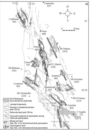
km) have been documented in the Norcia area, even though many others have occurred in time (Rovida et al., 2016). Fault data and earthquake focal mechanisms show a predom-inant NE-SW extension, but strike-slip and even reverse mechanisms have also been de-termined (Cello et al., 1997). These historical earthquakes, as the recent one, have been asso-ciated to the activity of a coherent and interact-ing active fault system (the Central Apennines Fault System in Cello et al., 1997) running in a NNW-SSE direction from Colfiorito to L’Aquila. This fault system (Figure 3) has also
been interpreted as the superficial expression of several deep seated seismogenic faults (Tondi and Cello 2003).
Figure 3 - The Central Apennines Fault System and relative interpreted seismogenic sources (Source: Tondi and Cello, 2003)
III. THE MONTE VETTORE ACTIVE FAULT The main active tectonic element in the Monte Vettore seismic area is a well preserved fault scarp exposed in bedrock, for a length of about 7 km along the western slope of Monte Vettore (Figure 1). The fault scarp branches into two splays: the eastern one strikes N150° (named in the official topographyc map of IGM as
“Cor-done del Vettore”), whereas the western fault
branch maintains a roughly constant
north-south trend. Along the eastern fault scarp, kinematic indicators (striae) from shear surfac-es in bedrock record a main left-lateral strike-slip motion along the fault planes oriented NNW-SSE and a normal behaviour, with a mi-nor sinistral component of slip, along the fault planes oriented NW-SE. On Figure 4 is shown the pattern of coseismic surface faulting along the Monte Vettore fault based on the results of our survey.
Figure 4 – Pattern of ground ruptures observed along the Monte Vettore fault. See text for details.
In particular, a set of ground ruptures was surveyed on the southern slope of Monte Vet-toretto in correspondence to the intersection between the Monte Vettore fault and the SP34 (province road). These en-echelon ruptures mainly strike between NNW-SSE, with a slight left-lateral horizontal component. They gener-ally affect colluvium and soil, whereas mid-way up the slope, ground ruptures are very close to the bedrock fault plane. This portion of the rupture is continuous for about 1.7 km. Continuing uphill to the NW, even more evi-dent ground ruptures are found in corre-spondence to the NW-SE trending fault seg-ment running just below the top of Cima Re-dentore (namely the “Cordone del Vettore” fault). Here the ruptures have been surveyed in detail for about 2.4 km. The end-to-end length of this rupture zone is greater than 4.5 km. According to the preliminary report
pro-vided by several authors
(
http://www.isprambiente.gov.it/files/notizie- ispra/notizie-2016/sisma-italia-
centra-le/REPORT_Amatrice_en_2016_09_16.compres
sed.pdf), ground ruptures are also present to
the south of the SP34 forming a total length of surface ruptures of at least 5.3 km. Along the SP34, where the fault crosses the road, repeat-ed field surveys have clearly displayrepeat-ed a post-seismic evolution of the rupture, whose verti-cal offset is continuing to increase with time.
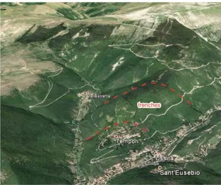
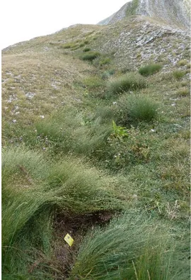
IV.THE DEEP-SEATED GRAVITATIONAL SLOPE DEFORMATION (DSGSD) OF MONTE VETTORE At the top of Monte Vettore, around 2230m a.s.l., along the alignment Punta di Prato Pu-lito–Monte Vettore, several trenches and
dou-ble ridges, roughly E-W oriented, can be ob-served (Figures 5 and 6a). All these features, showing lengths of more than 100m, width up to 4 meters and depth over than 1m and fa-voured by dip-slope attitude, were partially filled with debris and vegetated at the bottom. Inside, crack and fractures around 20 cm deep and 5cm wide, and free-faces on bedrock, as a consequence of the compaction of the filling material during the earthquake, have been ev-idenced (Figure 5). Also the south-western slope is strongly deformed and shows a con-vex morphology with presence of small dips and rounded counterslopes, filled by debris and soil material; despite the lithology is the same, the strata attitude changes along the slope with respect the top of the relief. Besides, compressive shear planes and small superficial landslides reactivated by the earthquake have been observed.
Figure 5 – Fractures and cracks observed along the bottom of the double ridge of Monte Vettore
The above mentioned morphological elements enable us to confirm the presence of a deep-seated gravitational slope deformation (DSGSD), already recognized by Aringoli et al. (2010a, 2014 and references within), that would affect the highest portion of the slope with a depth of hundreds of meters and partially cov-ered by debris material (Figure 6a and b). The genesis of this phenomenon, that can be
de-fined as a deep rock creep, can be associated to the high relief, generated by the quaternary tectonic uplift, and to the interaction between the fault system of Monte Vettore and the por-tion of the Monti Sibillini thrust. The triggering factors can be related to seismic events (as in this case) or the effects following extreme weather events.
Figure 6 – a) Panoramic view of the southern slope of Monte Vettore, with indication of the main geomor-phological elements (source Google earth): b) schematic cross section evidencing the geomorgeomor-phological mod-el of the DSGSD of Monte Vettore (see text for explanation)
V. PRELIMINARY CONCLUSIONS
This paper shows the result of preliminary field surveys carried out soon after the earthquake of August 24th 2016 in the area of Monte Vettore, where both an active fault and a previously mapped Deep-Seated Grav-itational Slope Deformation (DSGSD) are present. The survey carried out on the west-ern and southwest-ern slope of the Monte Vettore, allowed us to document the geometry, the kinematics and the dimensional properties of the ground ruptures along the previously mapped active fault. On the base of our find-ings, we may interpret these ground rup-tures as primary effects related to the mainshock. Geophysical data (e.g. distribu-tion of the aftershocs, InSAR and accelerom-etry data etc.) suggest that the fault causative of the mainshock which occurred on August 24th extends from south of Amatrice basin tothe north of Castelluccio basin for a total length of 20-25km. However, geological data indicates for these two areas (Castelluccio and Amatrice basins) two distinct seismo-genic faults (Tondi and Cello, 2003). On the base of both geological and geophysical data, we may suggest for this recent event a possi-ble short term interaction between the two seismogenic faults or a linkage at depth, as interpreted by Tondi et al. (1997). On the other hand, the survey carried out on the previously mapped Deep-Seated Gravita-tional Slope Deformation (DSGSD) along the southern slope of Monte Vettore, allowed us to report evidences of reactivation of the phenomenon, mostly located in the upper-most portion of the slope itself. The reactiva-tion is definitely associated with the effect of shaking related to the earthquake even though, given the structural setting and the
typology of movement, a continuous defor-mation process, favored by particularly in-tense weather events cannot be excluded.
R
EFERENCESAringoli, D., Gentili, B. and Pambianchi, G. (1996). The role of recent tectonics in con-trolling the deep-seated gravitational defor-mation of Mount Frascare (central Apen-nine). Geogr. Fis. Dinam. Quat., 19, 281-286.
Aringoli, D., Gentili, B. and Pambianchi, G. (2010a). Deep-seated gravitational slope deformations in active tectonics areas of the Umbria-Marche Apennine (central Italy).
Geogr. Fis. Dinam. Quat., 33 (2), pp. 127-140
Aringoli, D., Gentili, B., Materazzi, M. and Pambianchi, G. (2010b). Mass movements
in Adriatic Central Italy: Activation and evolu-tive control factors. In: Werner, E D. and
Friedman H.P., Eds., Landslides: Causes, Types and Effects, pp. 1-72
Aringoli, D., Cavitolo, P., Farabollini, P., Galindo-Zaldivar, J., Gentili, B., Giano, S. I., Lòpez-Garrido, A. C., Materazzi, M., Nibbi, L., Pedrera, A., Pambianchi, G., Ruano, P., Ruiz-Constàn, A., Sanz de Galdean,o C., Sa-velli, D., Tondi, E. and Troiani, F. (2014). Morphotectonic characterization of the qua-ternary intermontane basins of the Umbria-Marche Apennines (Italy). Rend. Lincei
Scien-ze Fisiche e Naturali
Boncio P.; G. Lavecchia; Milana G.; Rozzi B. (2004). Seismogenesis in central Apen-nines, Italy: an integrated analysis of minor earthquake sequences and structural data in the Amatrice-Campotosto area. Annals of
Ge-ophysics, 47/6, 1723-1742.
Cello, G., Mazzoli, S., Tondi, E. and Tur-co, E. (1997). Active tectonics in the central Apennines and possible implications for seismic hazard analysis in peninsular Italy.
Tectonophysics 272, 43–68.
DISS Working Group (2015). Database of Individual Seismogenic Sources (DISS),
Ver-sion 3.2.0: A compilation of potential sources for earthquakes larger than M 5.5 in Italy
and surrounding areas.
http://diss.rm.ingv.it/diss/, Istituto Na-zionale di Geofisica e Vulcanologia; DOI:10.6092/INGV.IT-DISS3.2.0
Galadini, F. and Galli P. (2000). Active Tectonics in the Central Apennines (Italy) – Input Data for Seismic Hazard Assessment. Natural Hazards, 22/3, 225–268.
Pierantoni, P.P., Deiana, G., Galdenzi, S. (2013). Stratigraphic and structural features of the Sibillini Mountains (Umbria-Marche Apennines, Italy). Italian Journal of Geosciences 132 (3), 497-520.
Rovida, A., Locati, M., Camassi, R., Lolli, B., Gasperi (2016). CPTI15, the 2015 version of the Parametric Catalogue of Italian Earth-quakes. Istituto Nazionale di Geofisica e Vulcanologia.
doi:http://doi.org/10.6092/INGV.IT‐CPTI1 5
Tondi, E., Cello G., Mazzoli S. (1997). Strutture sismogenetiche in Appennino cen-trale: potenziale sismico, analisi frattale e processi di crescita. Il Quaternario, 10 (2), 409-414.
Tondi, E. and Cello, G. (2003). Spatiotem-poral Evolution of the Central Apennines Fault System (Italy). Journal of Geodynamics, 36, 113-128.