Studies on the Value of Cultural Heritage
201
9
19
IL CAPITALE CULTURALE
n. 19, 2019
ISSN 2039-2362 (online) Direttore / Editor Massimo Montella † Co-Direttori / Co-Editors
Tommy D. Andersson, Elio Borgonovi, Rosanna Cioffi, Stefano Della Torre, Michela di Macco, Daniele Manacorda, Serge Noiret, Tonino Pencarelli, Angelo R. Pupino, Girolamo Sciullo
Coordinatore editoriale / Editorial Coordinator Giuseppe Capriotti
Coordinatore tecnico / Managing Coordinator Pierluigi Feliciati
Comitato editoriale / Editorial Office
Giuseppe Capriotti, Mara Cerquetti, Francesca Coltrinari, Patrizia Dragoni, Pierluigi Feliciati, Valeria Merola, Enrico Nicosia, Francesco Pirani, Mauro Saracco, Emanuela Stortoni, Federico Valacchi
Comitato scientifico - Sezione di beni culturali / Scientific Committee - Division of Cultural Heritage
Giuseppe Capriotti, Mara Cerquetti, Francesca Coltrinari, Patrizia Dragoni, Pierluigi Feliciati, Maria Teresa Gigliozzi, Susanne Adina Meyer, Massimo Montella †, Umberto Moscatelli, Sabina Pavone, Francesco Pirani, Mauro Saracco, Emanuela Stortoni, Federico Valacchi, Carmen Vitale
Comitato scientifico / Scientific Committee Michela Addis, Tommy D. Andersson, Alberto Mario Banti, Carla Barbati, Sergio Barile, Nadia Barrella, Marisa Borraccini, Rossella Caffo, Ileana Chirassi Colombo, Rosanna Cioffi, Caterina Cirelli, Alan Clarke, Claudine Cohen, Lucia Corrain, Giuseppe Cruciani, Girolamo Cusimano, Fiorella Dallari, Stefano Della Torre, Maria del Mar Gonzalez Chacon, Maurizio De Vita, Michela di Macco, Fabio Donato, Rolando Dondarini, Andrea Emiliani †,
Emanuele Invernizzi, Lutz Klinkhammer, Federico Marazzi, Fabio Mariano, Aldo M. Morace, Raffaella Morselli, Olena Motuzenko, Giuliano Pinto, Marco Pizzo, Edouard Pommier †, Carlo Pongetti, Adriano Prosperi, Angelo R. Pupino, Bernardino Quattrociocchi, Mauro Renna, Orietta Rossi Pinelli, Roberto Sani, Girolamo Sciullo, Mislav Simunic, Simonetta Stopponi, Michele Tamma, Frank Vermeulen, Stefano Vitali
Web
http://riviste.unimc.it/index.php/cap-cult e-mail
[email protected] Editore / Publisher
eum edizioni università di macerata, Centro direzionale, via Carducci 63/a – 62100 Macerata tel (39) 733 258 6081 fax (39) 733 258 6086 http://eum.unimc.it [email protected] Layout editor Roberta Salvucci
Progetto grafico / Graphics +crocevia / studio grafico Rivista accreditata AIDEA Rivista riconosciuta CUNSTA Rivista riconosciuta SISMED Rivista indicizzata WOS Rivista indicizzata SCOPUS Inclusa in ERIH-PLUS
The management of cultural
heritage and landscape in inner
areas
edited by Mara Cerquetti, Leonardo J.
Sánchez-Mesa Martínez, Carmen Vitale
stendono a prendere il sole. Li osservo e mi sforzo di comprendere. Nessuno può capire cosa c’è sotto le cose. Non c’è tempo per fermarsi a dolersi di quello che è stato quando non c’eravamo. Andare avanti, come diceva Ma’, è l’unica direzione concessa. Altrimenti Dio ci avrebbe messo gli occhi di lato. Come i pesci1.
Quando cammino nei prati attorno al Santuario, quasi sempre solo, ripenso a nonno Venanzio che, da giovane biscino, pascolava il gregge negli stessi terreni. Mi affascina il fatto che in questo luogo la cui cifra, agli occhi di chi guarda adesso la mia scelta di vita, è la solitudine, nei secoli addietro abitassero oltre duecento persone. Ancora negli anni Cinquanta, ricorda mio nonno, erano quasi un centinaio gli abitanti di Casette di Macereto tra contadini, mezzadri, mogli, pastori e un nugolo di bambini che costringeva il maestro a salire ogni giorno da Visso per fare lezione a domicilio.
Era una comunità compatta, coordinata come lo può essere quella delle società operose degli insetti: api, formiche, tremiti, ma cosa più sorprendente che mai, una comunità niente affatto statica o chiusa2.
1 Balzano M. (2018), Resto qui, Torino: Einaudi, p. 175.
«Il capitale culturale», n. 19, 2019, pp. 181-209 ISSN 2039-2362 (online); DOI: 10.13138/2039-2362/1965
Information system for the
management of the Archaeological
Map of Macerata Province: the
archaeological potential map
as a tool for the management
of the archaeological heritage
and territorial planning of the
inner areas
*Chiara Capponi, PhD student in Linguistic, philological, literary studies, University of Mace-rata, Department of Humanities, Corso Cavour, 2, 62100 MaceMace-rata, e-mail: c.capponi@studenti. unimc.it.
Chiara Capponi
*Abstract
The research is aimed at creating a map of archaeological risk and a map of archaeological potential for the province of Macerata. The exam of the data of the Archaeological Map of Macerata province highlights different degrees of information, which depend on the context(s) of discovery and the level of analysis. The adoption of Geographic Information Systems (GIS) for the archaeological data and the management of the same in a Territorial Information System (SIT) allow the creation of models for spatial analysis. These models, applied to a territory for which archaeological data are insufficient, might be useful in interpreting settlement patterns and archaeological processes in a given area. Particular attention was paid to the geological information. The analysis of all the data archived in the SIT, which will certainly suggest new research topics to deepen, is already advantageous in the governance and strategic development of the territory, particularly in the inner areas.
Nel contributo è dettagliata la metodologia applicata alla ricerca finalizzata alla creazione della carta del rischio e della carta di potenzialità archeologica della provincia di Macerata con particolare riguardo alle aree interne. L’esame dei dati archeografici evidenzia differenti gradi di informazione determinati dalla tipologia del ritrovamento archeologico e dall’intensità della ricerca. L’archiviazione in ambiente GIS dei dati archeologici e la successiva gestione degli stessi in un sistema informativo territoriale (SIT) consentono la creazione di modelli per analisi spaziali. Tali modelli, proiettati nei territori per i quali le informazioni archeologiche sono scarse o nulle, rappresentano la base per la valutazione storica delle modalità insediative e di sfruttamento del territorio nel suo complesso. Particolare attenzione è rivolta alle informazioni geologiche. L’analisi e la rielaborazione di tutti i dati all’interno di un SIT, permettendo di creare differenti tematismi, si presenta particolarmente utile nelle aree interne per tutte le scelte progettuali legate alla governance, allo sviluppo del territorio e alla pianificazione intersettoriale.
The research is part of the CAM project (Marche Archaeological Map), supported by the Marche Region and lead, for the province of Macerata, by Roberto Perna of the University of Macerata, in cooperation with the Province of Macerata, the Macerata Museum System association and the Marche Archaeology, Fine Arts and Landscape Superintendency Department1. This
on-going study has been carried out during the Ph.D. in Linguistic, philological, literary studies (XXXI Cycle, EUREKA course) in collaboration with PlayMarche s.r.l., a spin-off of the University of Macerata. The research is aimed at creating a map of archaeological risk and the map of archaeological potential for the area in the province of Macerata by developing simulation models and relative projections that produce graphic depictions of the territorial areas most suited to stable settlement under the form of “risk ranges”2.
A territorial information system has been created for this end organised on the following different databases and charts:
– regional technical map (CTR)3; – colour digital orthophoto map4;
1 Perna 2001, 2002; Perna, Orsetti 2001; Capponi, Perna 2012.
2 The branch of spatial analysis and simulation with the prediction of archaeological “risk”
was developed early parallel with the development of mathematical-statistical surveys applied to geography, urban sociology and similar subjects (see Azzena 1987 and 2009; Fabiani et al. 2013; Gelichi 2008; Moscati 1998, 2013). Regionally, this is the first experiment on a vast scale; similar studies have been prepared for limited portions of land: Ascani et al. 2004; Perna 2004a, 2004b, 2006.
3 The reference map basis used is regional maps (CTR) for the province of Macerata on the
scale of 1:10,000. The reference geodetic map system is “Gauss-Boaga Fuso Est” (Code EPSG3004), with the geodetic reference based on the international ellipsoid directed towards Monte Mario (Rome 1940).
4 Colour digital orthophoto map of the province of Macerata on a scale of 1:10,000 with
updated to the year 2010, created by the Agency for funding in agriculture (AGEA) following an agreement signed in 2010 with the Marche Region.
– map of the use of land5;
– regional environmental landscape plan6;
– geological map of the Marche Region and soil map of the provinces;
– SIRPaC database of the archaeological map for the province of Macerata; – geographical/spatial unit regarding the areas subject to archaeological
restriction;
– DB regarding historical roads.
1. Geology and geomorphology
This research is based on the assumption that the site vocation and the possibility of finding archaeological deposits largely also depend on the territory’s geomorphology. The geomorphological data was crossed with the study of the area’s historical evolution, as in the choice of areas allocated for various types of land occupation, accessibility of resources, above all water, the road system, proximity to an important urban centre or an important place of worship take on significant roles. Man’s wishes constitute a primary source in the decision of which areas to settle in, respecting the potential that the environment offers and also via a selection of the most suitable places, that is not necessarily repeated in the same way in all eras and in all areas.
2. Archaeological map database for the province of Macerata
This database collects all the news regarding archaeological evidence found from bibliographical and archive collections (starting with the Marche Superintendency’s archives)7. The CAM data collected in the 2000 and 2003
study campaigns, promoted directly by the Marche Region and in the 2007, 2010 and 2011 campaigns supported by the Province of Macerata, specifically by the catalogue centre of the province of Macerata Museum System association, was integrated with the data from recent research to develop the SIT. More specifically, the data have been implemented, with the results from studies carried out by the Department of Humanities, the former S.A.S.A. (Archaeological Science and
5 The Region’s map of the use of land (stages completed 2007) on a scale of 1:10,000. 6 PPAR (Regional Environmental Landscape Plan), in detail: Tab. 2 – Morphological groups;
Tab. 3A – Geological emergencies; Tab. 10 – Archaeological and historical remembrance places; Tab. 13 – Geomorphological emergencies; Tab. 17 – Archaeological sites of interest that have been outlined on maps. Future implementations may foresee the inclusion of the PRG (Regional General Plan) and the PTC (Territorial Coordination Plans), regarding the province of Macerata.
Ancient History Department) at the University of Macerata8. Edited data from
the University of Ghent’s PVS project9 and the R.I.M.E.M. project directed by
Professor Umberto Moscatelli from the University of Macerata10 have also been
entered. Collaboration with the Archaeological Superintendency Department allowed the entry of information about all archaeological interventions digs and/or assistance up to the year 201611.
The creation of the known map, where the various findings have been located and visualised, was the premise on which the study was based. This action provided an analysis of archaeological knowledge in the Province of Macerata to date. There are different degrees of information present, determined by the type of archaeological finding (casual discovery, planned excavation, emergency excavation, reporting) and the intensity of the search. Direct surveys, with topographical recognition, that were conducted as part of diversified projects, were only carried out on some part of the provincial area and are more limited in internal areas where accessibility and visibility conditions are not as favourable due to the presence of elevations, steep slopes, woodland or uncultivated areas12. The municipalities that fall into this area
are Apiro, Belforte del Chienti, Caldarola, Camerino, Camporotondo di Fiastrone, Castelraimondo, Castelsantangelo sul Nera, Cessapalombo, Cingoli, Colmurano, Esanatoglia, Fiastra, Fiuminata, Gagliole, Loro Piceno, Matelica, Montecavallo, Muccia, Penna San Giovanni, Pievetorina, Pioraco, Poggio San Vicino, Ripe San Ginesio, San Ginesio, Sarnano, Sant’Angelo in Pontano, Sefro, Serrapetrona, Serravalle di Chienti, Tolentino, Ussita, Valfornace and Visso (see the list of archaeological sites in tab. 1).
3. Archiving archaeological data in a GIS environment
The original archaeological data were registered in the SI (Archaeological Site) sheets (Si.mdb) in the SIRPaC software (Sistema Informativo Regionale
del Patrimonio Culturale/Regional Information System of Cultural Heritage)
8 Capponi Perna 2012; Perna 2012a, 2012b, 2012c, 2014, 2015, 2018; Perna et al. 2014. 9 Percossi et al. 2006; Vermeulen et al. 2017.
10 Moscatelli 2013, 2015.
11 It has also been possible to consult current archives at the Marche Archaeological
Superintendency Department and documents kept in the Dossier archive.
12 The municipalities involved in the systematic surveys to date are Cingoli (Calvelli 1999
and work thanks to the research by Alberto Calvelli, unpublished), Caldarola, Cessapalombo, San Ginesio, Valfornace (portions of the land in these municipalities are included in the R.I.M.E.M. project), Serravalle del Chienti and Camerino, the subject of surveys by Dr. Bonomi Ponzi (1992); Matelica with studies by Dr. Biocco (Biocco 2000, 2009); Castelraimondo, Camerino, Fiuminata and Pioraco that are involved in the PVS project; Tolentino and Loro Piceno included in the CAM project by the Department of Humanities of the University of Macerata.
developed with Microsoft Access from the Marche Region13. As this research
is the continuation of the previous CAM project, which was developed in a Windows environment, we continued with this choice in order to ensure compatibility with the bodies participating in the project, such as the Marche Archaeology, Fine Arts and Landscape Superintendency Department, the Marche Region and the Department of Humanities at the University of Macerata. This research, therefore, does not use a dedicated relational database. The simple, rapid interface from the SIRPaC Programme, the verification procedures for the mandatory nature of fields and terminology dictionaries were used.
The SIRPaC, developed according to the standards of the ICCD (Central Institute for the Catalog and Documentation), allows the export of data in two tracks:
– *.trc for data transfer; – *.cbc an extended path.
The site sheets (SI) for known archaeological presences in the provincial area provide multiple data which was selected by migrating information into the layer file attributes table, named Archaeological Map. We worked directly on the QGis database for implementation. Additional fields were entered on the layer file attributes table (fig. 1).
The selected information was about:
– the type of archaeological evidence, divided into type, macrotype, definition and description;
– geographic location divided into area it belongs to, municipality, location,
placement reliability, coordinates.
Implementation concerned the chronological information that could not be directly migrated as the field provides for the possibility of repeating data entry if the archaeological evidence spans a very broad period of time14. Likewise,
implementation of the tables was necessary to enter information about the depth of the archaeological presences, as the data, where present, was contained in free descriptions provided for by the SIRPaC database, therefore in a non-usable mode. All the archaeological data have been georeferenced according to the rate of reliability, which led to the choice of geometries to be used during data entry. To position the archaeological findings in the reference geomorphological context, it was necessary to separate the archaeological evidence that can reliably be located from the others. The sites with “precise” or “good” location were restored in their actual territorial size, using the polygonal graph when the extension exceeded a diameter of 30 metres. All the historical-archaeological data that does not lead to providing the perimeter of an archaeological area,
13 Perna 2001; Baldelli et al. 2004.
14 Archiving of the chronological data in a GIS environment is one of the most difficult aspects
of managing data. On the structuring of chronological data in the SIRPaC programme and their use in a GIS environment, see Gnesi et al. 2007, pp. 122-125.
but which is useful historical-archaeological data for producing the potential map, are arranged as “finding reports” and are shown on a point graph (fig. 2).
4. Planning the SIT and the changeover to an AIS (Archaeological
Information System)
Planning the SIT involved data entry, processing a spatial database and subsequent manipulation and analysis. The platform was created using QGis 2.1.8. “Las Palmas”. QuantumGIS is a software free and open-source (FOSS)15.
The software allows you to create, edit, visualise, analyse and publish geospatial information. Its main features are the management of geometrical data, the ability to georeference all the data, the ability to characterise all registered data and thematic or spatial search potential. The input files were managed in a geodatabase as a feature-class that can be exported in shapefile format (.shp)16.
The geodatabase contains:
– the description of the environment (basic map dataset, dataset orthophoto map, dataset use of land, dataset modern road system);
– geological description (geomorphology dataset, geopedology dataset, PAI dataset);
– archaeological description (archaeological map dataset, historical road dataset, dataset of areas subject to archaeological restriction).
All the system information has been processed and encoded for each thematism (horizontal mode) and for joint thematisms on the same geographic area (vertical mode). The purpose is to process all the information about the archaeological sites, the risk sources and the geomorphological characteristics in order to provide diversified information according to the different types of evaluation necessary. The Boolean overlapping of thematic maps, the calculation of statistic correlations between environmental information and sites and the predictive analyses combined into a single work tool suggest a definition of this AIS (Archaeological Information System) research.
Its principal functions are:
– information archiving and processing; – production of information and data reading;
– support for analysing and making decisions or planning interventions.
15 The QGIS is a project of the Open Source Geospatial Foundation (OSGeo) and is under
development by a developer community: <https://qgis.org/>, 01.04.2019.
16 Shapefile has three main files that contain both spatial information and the attributes of a
database file. This format was made public by ESRI, the company that developed it, in order to provide data swapping between different systems. ESRI Shapefile technical description: <http:// www.esri.com/library/whitepapers/pdfs/shapefile.pdfs>, 01.04.2019.
5. The archaeological risk map
To process the evaluation of risk, it is necessary to outline the risk sources that lead to the vulnerability of findings. The actions that interact with archaeological sites are split into:
– anthropic actions (in this case, the following have been taken into consideration: construction expansion areas, areas close to main roads); – natural actions (in this case, the following were taken into consideration:
flooding areas, landslide areas).
The archaeological risk map has been organised on three levels. The first level provides an evaluation of the archaeological site’s state and historical-cultural value17. The parameters taken into consideration refer to the type of
site, its interpretability and its continuity. Specifically, archaeological sites have been categorised as follows:
– outcrop areas category vulnerability 1;
– areas with structures (civil, funerary, productive) category vulnerability 2; – settlements category vulnerability 3;
– conservative habitats (municipium, colony) category vulnerability 4; The second level identifies archaeological site exposure to the level of vulnerability, analysing the spatial distribution of sources of risk and their possible joint presence. It is thus possible to highlight site exposure to current anthropic or natural risk sources, and to highlight the dependency on one or more modern risk sources and consequently produce a scale of exposure to risk. The risk is at its maximum when all 4 risk sources are present and none of them is absent (figs. 3-5).
The third level evaluates the risk value for each site, through the simultaneous analysis of both the state of conservation and exposure to risk sources.
In other words, considering risk as the product between the site’s state of conservation and its exposure to damage sources, it is possible to generate a list of sites, according to the risk to which they are subjected.
6. The archaeological potential map
A predictive approach was used with this analysis, that allowed the archaeological risk to be integrated with archaeological potential. This type
17 In this research, it was not possible to associate the concept of vulnerability with the
archaeological site’s state of conservation to the lack of data on the structural deterioration of archaeological evidence. For the census of the archaeological heritage of the province of Macerata in the Risk Map produced by the Istituto Superiore per la Conservazione (formerly ICR), please refer to the website <http://www.cartadelrischio.it/>, 01.04.2019.
of map presumes an overall optimisation of the territory, as the identification of particular characters of the territory to be associated with a historical-archaeological study is at the basis of it. A cross-analysis of the historical-archaeological presences and the morphological data was carried out for this purpose. The archaeological sites were selected according to their reliability rate; the evidence with exact or good location was taken into consideration for the study. The range of each site was expanded with a minimum buffer area allocated according to the type of site (fig. 6).
Historical roads and preserved centurial limits were considered in the dataset; in this case too, a minimum distance was created, a buffer zone of 50 metres for roads and 25 metres for centurial persistence.
A statistical spatial analysis was then carried out using the Kernel Density Estimation (KDE) method from the Point Pattern Analysis method, via the Q-GIS Heatmap tool, and the buffer analysis in order to create statistical maps that are related to the geophysical characteristics of the territory18.
With regards to the internal areas of the province of Macerata, only a small part of the Apennine territory was frequented or settled in (fig. 6). Erosions and hydrogeological instability in this mountainous area may have caused the moving or disappearance of archaeological deposits that are mostly on the surface. Archaeological data that is suitable for analysis and processing come from the municipalities of Camerino, Castelraimondo, Cingoli, Loro Piceno, Matelica, Muccia, San Severino Marche, Serravalle del Chienti, Tolentino, Valfornace. Archaeological information in these areas varies in type and chronology and the forms of population and use of the land can be associated with the distribution of some artificial elements of the landscape, such as the centurial main roads, road networks and natural internal penetration routes, as well as the presence of dominant centres, including the ones allocated for the practice of worship19. In the municipalities of Castelsantangelo sul Nera,
Esanatoglia, Fiastra, Fiuminata, Montecavallo, Sefro, Ussita and Visso with their high altitude and elevations of more than 1000 metres above sea level, archaeographic data, which is limited and refers almost exclusively to news of casual findings rarely located with certainty, can be used to check the data produced in the initial analysis20.
18 On Point Pattern Analysis see Hodder, Orton 1976, p. 30. For the determination of radius
see Conolly, Lake 2006, p. 186. The method used has been adopted by the Mappa project: Fabiani et al. 2013.
19 See the list of archaeological sites on this matter. For details of each archaeological evidence
and for the analysis of historical roads, please refer to the Province of Macerata Archaeological Map currently being printed. For sites of worship see Perna et al. 2013.
20 To date, no archaeological sites are known for the municipalities of Bolognola, Gualdo and
7. Future outlook: the archaeological potential map as a governance tool The archaeological potential map is an alternative to the so-called emergency archaeology, intended as a dig started up when the threat of destruction becomes clear for the archaeological item. This tool is a part of preventive archaeology actions, in fact, and corresponds to the contents of the document produced by the Ministerial Commission for creating the archaeological information system of Italian cities and their territories21.
At the same time, the traditional interpretation of archaeological landscape, and sets of sites is overcome, around which a minimum distance is recognised22
as the areas where archaeological presences are predictively located are restored alongside the known archaeological areas. The instrument is especially useful for internal areas where known archaeological testaments are conditioned primarily by the geophysical characteristics of this territory; characters that have affected direct archaeological research in the field over the years.
In order to include it in the territorial planning actions, each archaeological site that is analysed or “reconstructed” will be assigned, in accordance with the Marche Region and the Archaeological Superintendency Department, a protection category to be added to the ones already stated in the PPR (Regional Environmental Landscape Plan)23. With regard to archaeological heritage,
to date only the area of archaeological interest bound pursuant to art. 142/ letter m of the Code of Cultural Heritage and Landscape are considered in the PPAR24. The instruments of the local restriction, drawn up by the Ministry, are
not sufficient for the actions of protection and safeguarding of the widespread archaeological heritage.
The area of archaeological respect, including a band of “conditioned protection”, aimed at correct understanding and safeguarding can be classified
21 On 24 January 2007, the Minister for Cultural Heritage of the time, Francesco Rutelli,
appointed the preparatory commission for creating the Archaeological Information System of Italian cities and their Territories, chaired by Andrea Carandini, with the result being a final report that can be consulted in Carandini 2008 (pp. 199-207). On the one hand, the document highlights the lack of coordination among the various research activities aimed at creating archaeological territorial information supports (for further information on this matter, see Azzena 2009); on the other hand, it supports the necessary collaboration between universities, to which knowledge of protection and optimisation is transferred, the State to which protection “illuminated by knowledge, regulated by uniform procedures and aimed at optimisation and fruition” is transferred and the Regions and other territorial bodies for planning, optimisation and fruition. Collaboration already promoted by the Legislative Decree 42/2004, “Code of Cultural Heritage and Landscape”, art. 1, par. 3 and art. 5.
22 On this matter Brogiolo 2009.
23 Law 8 August 1985, No. 431 and Regional Law 8 June 1987, No. 26. Approved by
Administrative Resolution 3 November 1989, No. 97, currently under review.
24 Legislative Decree 22 January 2004, No. 42, pursuant to art. 10 of Law 6 July 2002, No.
137. The Web Gis of Landscape Heritage has been available since February 2017 at the link <http:// ctr.regione.marche.it/BP/default.aspx>, 01.04.2019.
according to the configuration and size in at least 4 subcategories, to which specific prescriptions should be associated:
– category a: archaeological complexes subject to restriction;
– category b: areas of ascertained and relevant archaeological size, areas with considerable presence of materials (settlements, necropolises, production and agricultural structures, portions of roads, aqueduct ruins), that have already been found or that are not yet touched by regular archaeological excavations;
– category c: concentrated areas of archaeological materials or report of findings; areas of respect or integration or safeguarding of paleo-habitats, sample areas for the conservation of particular statements of types and archaeological sites; areas with considerable archaeological risk;
– category d: areas with archaeological potential, divided in turn into high, medium and low potential.
The aim of this study is to provide all the necessary, useful data for the planning and management of administrative, management and tourist-cultural interventions. The archaeological potential map could, therefore, run alongside current tools, to provide additional information for a historical understanding of the territory and to favour territorial planning actions, the only useful instrument for safeguarding this widespread heritage. In this sense, the methodological tool that this research embraces is global archaeology that does not recognise the historical value of each site but of the anthropic landscape overall, abiding by the European Landscape Convention guidelines25.
References / Riferimenti bibliografici
Ascani C., Campagnoli P., Dall’Aglio C., Del Grande C., Campanelli G., Trotta S. (2004), GIS, archeologia e analisi territoriale: il caso del comprensorio di
San Bartolo (Pesaro-Urbino), in Topografia archeologica 2004, pp. 89-94.
Azzena G. (1997), Questioni terminologiche – e di merito – sui GIS in archeologia, in Sistemi informativi e reti geografiche in archeologia: GIS-INTERNET, Conference proceedings (Certosa di Pontignano, 11-17 December 1995), edited by A. Gottarelli, Firenze: All’Insegna del Giglio, pp. 33-43.
25 The landscape topic is at the centre of the Marche Region’s activity agenda, also with
regard to the obligation introduced by art. 156 of the Legislative Decree 42/2004 of checking the conformity of one’s landscape plan with the requisites set by the same decree (art. 143). Additional activities for the updating of the current landscape plan concern the management of procedures (through four provincial committees) for finding new areas to place until landscape restriction, and the implementation of studies and further research on territory transformations in the “Territory and Landscape Observatory”.
Azzena G. (2000), Rischio archeologico: se lo conosci lo eviti, «Archeologia e Calcolatori», n. 11, pp. 375-381.
Azzena G. (2009), Punto di non-ritorno (cartografia numerica, sistemi
informativi territoriali, analisi spaziali), «Archeologia e Calcolatori», n. 20,
pp. 169-177.
Baldelli G., Gobbi C., Marchegiani P., Pignocchi G. (2004), Catalogare il
patrimonio archeologico: l’esperienza marchigiana, «Picus», n. 24, pp.
223-240.
Biocco E. (2000), Matelica, Roma: L’Erma.
Biocco E. (2009), Il popolamento nel territorio di Matelica in età
tardo-repubblicana, in Fabriano e l’area appenninica dell’alta valle dell’Esino dall’età del Bronzo alla romanizzazione. L’identità culturale di un territorio fra Adriatico e Tirreno, Conference proceedings (Fabriano, 19-21 May
2006), edited by M. Silvestrini, T. Sabbatini, Ancona: Saci, pp. 229-254. Bonomi Ponzi L. (1992), Occupazione del territorio e modelli insediativi nel
territorio plestino e camerte in età protostorica, in La civiltà picena nelle Marche. Studi in onore di Giovanni Annibaldi, Conference proceedings
(Ancona, 10-13 July 1988), Ripatransone: Maroni, pp. 204-244.
Brogiolo G.P. (2009), La tutela dei paesaggi storici tra archeologia preventiva e
archeologia d’emergenza, in V congresso nazionale di archeologia medievale,
Conference proceedings (Foggia-Manfredonia, 30 September – 3 October 2009), edited by G. Volpe, P. Favia, Firenze: All’Insegna del Giglio, pp. 3-6. Calvelli A. (1999), Alcuni esempi di Applicazioni GIS alle ricerche topografiche
nel territorio di Cingoli (Macerata), «Archeologia e Calcolatori», n. 10, pp.
189-205.
Capponi C., Perna R. (2012), Città e campagna nella valle del Chienti in età
repubblicana ed imperiale. La carta archeologica della provincia di Macerata,
in Processi formativi 2012, pp. 149-164.
Carandini A. (2008), Archeologia classica, Torino: Einaudi.
Conolly J., Lake M. (2006), Geographical information Systems in Archaeology, Cambridge: University Press.
Fabiani F., Gattiglia G., Ghizzani Marcia F., Grassini F., Gualandi M.L., Parodi L. (2013), Analisi spaziali e ricostruzioni storiche, in Mappa 2013, pp. 45-87.
Gelichi S. (2008), Solo un Giano bifronte? Qualche riflessione sull’uso della
fonte archeologica, in Missioni archeologiche e progetti di ricerca e scavo dell’Università Ca’ Foscari di Venezia (VI Giornata di Studio, Venezia 2008),
Venezia: Ca’ Foscari, pp. 17-19.
Gnesi D., Minguzzi S., Moscatelli U., Virgili S. (2007), Ricerche sugli insediamenti
medievali nell’entroterra marchigiano, «Archeologia Medievale», n. 34, pp.
113-140.
Hodder I., Orton C. (1976), Spatial Analysis in Archaeology, Cambridge: University Press.
Mappa (2013), Mappa: metodologie applicate alla predittività del potenziale archeologico, vol. II, Roma: Nuova Cultura.
Moscatelli U. (2013), Spazi montani e approccio archeologico. Considerazioni
a margine del progetto R.I.M.E.M., in Le aree montane come frontiere e/o spazi di interazione e connettività, Conference proceedings (Udine-Tolmezzo,
10-12 December 2009), edited by S. Magnani, Roma: Aracne, pp. 551-566. Moscatelli U. (2015), Progetto R.I.M.E.M.: problematiche (e dati) delle
ricognizioni nelle aree interne delle Marche, «Il capitale culturale. Studies on the Value of Cultural Heritage», n. 12, pp. 183-221.
Moscati P. (1998), GIS applications in Italian archaeology, «Archeologia e Calcolatori», n. 9, pp. 191-236.
Moscati P. (2013), Archaeology and computers: perspectives of the 21stcentury, in Mediterranean Archaeology: A GID-EMAN Training Course, Conference proceedings (Roma, 8-10 October 2012), edited by M. Brunori, L. Godart, E. La Rocca, P. Sommella, Roma: Scienze e Lettere, pp. 91-108.
Percossi E., Pignocchi G., Vermeulen F. (2006), I siti archeologici della vallata
del Potenza. Conoscenza e tutela, Ancona: Il Lavoro Editoriale.
Perna R. (2001), Il progetto di carta archeologica della regione Marche, in
Rischio archeologico 2001, pp. 328-333.
Perna R. (2002), La carta archeologica, in La catalogazione del patrimonio
culturale nelle Marche, Ancona: Regione Marche, p. 18.
Perna R. (2004a), Un sistema informativo territoriale per la gestione del Parco
Archeologico di Cupra Marittima (Ascoli Piceno), in Topografia archeologica
2004, pp. 113-124.
Perna R. (2004b), Dalla carta archeologica alla carta del rischio, in Le Marche
archeologiche, Conference proceedings (Abbadia di Fiastra, 20-21 November
2002), edited by R. Orsetti, Ancona: Regione Marche, pp. 294-298.
Perna R. (2006), L’elaborazione del sistema informativo territoriale in ambito
GIS, in Verso un piano per il Parco Archeologico di Urbs Salvia, Ancona:
Regione Marche, pp. 94-105.
Perna R. (2012a), L’uso delle immagini aeree per la carta archeologica della
provincia di Macerata, «Archeologia Aerea», n. 4-5, pp. 91-96.
Perna R. (2012b), Nascita e sviluppo della forma urbana in età romana: alcuni
casi nelle città delle Regiones V e VI, in Processi formativi 2012, pp.
375-412.
Perna R. (2012c), Archeologia romana nella Riserva Naturale Abbadia di
Fiastra, Macerata: Simple, pp. 1-64.
Perna R. (2014), Urbs Salvia ed il suo territorio in età repubblicana, in Amore
per l’antico dal Tirreno all’Adriatico, dalla preistoria al medioevo e oltre. Studi di antichità in onore di Giuliano de Marinis II, edited by G. Baldelli, F.
Lo Schiavo, Roma: Scienze e Lettere, pp. 703-719.
Perna R. (2018), Il ruolo dei luoghi di culto nell’ambito dei processi formativi
risultati, in Il ruolo del culto nelle comunità dell’Italia antica tra IV e I sec. a.C. Strutture, funzioni e interazioni culturali, edited by E. Lippolis, R.
Sassu, Roma: Quasar, pp. 397-441.
Perna R., Orsetti R. (2001), Sistema Informativo Territoriale per la catalogazione
e gestione degli edifici di interesse storico-artistico della Provincia di Macerata,
in Usi e consumi dell’informazione geografica, Conference proceedings (Roma, 23-25 May 2001), edited by G. Gabrielli, Roma: MondoGIS, pp. 217-219.
Perna R., Antolini S., Capponi C., Cingolani S., Marziali D. (2014), Le
attestazioni dei culti nella regio V e nell’Umbria adriatica in età romana,
in Epigrafia e archeologia romana nel territorio marchigiano. In memoria
di Lidio Gasperini, Conference proceedings (Macerata, 22-23 April 2013),
edited by G. Paci, Tivoli: Tored, pp. 493-570.
Processi formativi (2012), I processi formativi ed evolutivi della città in area adriatica, edited by G. de Marinis, G.M. Fabrini, G. Paci, R. Perna, M.
Silvestrini, Oxford: Archeopress.
Rischio archeologico (2001), Rischio archeologico: se lo conosci lo eviti,
Conference proceedings (Ferrara, 24-25 March 2000), edited by M.P. Guermandi, Firenze: All’Insegna del Giglio.
Topografia archeologica (2004), Topografia archeologica e sistemi informativi,
Conference proceedings (Borgoricco, 20 April 2001), edited by G. Rosada, Roma: Quasar.
Vermeulen F., van Limbergen D., Monsieur P., Taelman D. (2017), The Potenza
Valley survey (Marche, Italy). Settlement dynamics and changing material culture in an Adriatic valley between Iron Age and Late Antiquity, Roma:
Appendix
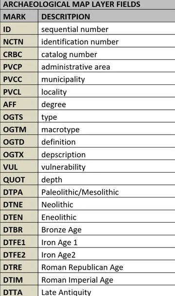
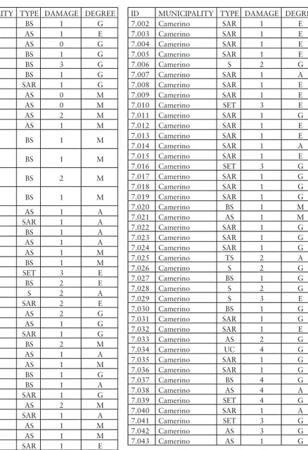
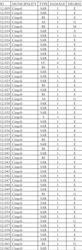
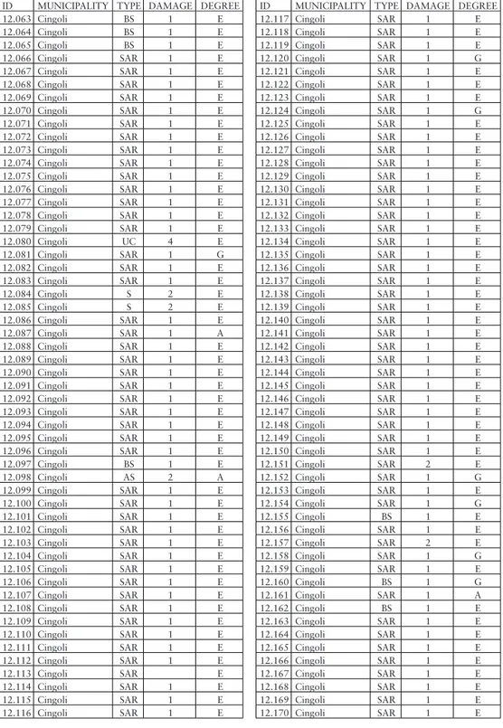
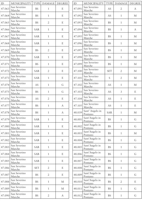
Tab. 1. List of archaeological sites, divided by municipality with a list of the types of evidence, damage, and degree of placement reliability
ID MUNICIPALITY TYPE DAMAGE DEGREE 2.001 Apiro BS 1 G 2.002 Apiro AS 1 E 2.003 Apiro AS 0 G 2.004 Apiro BS 1 G 2.005 Apiro BS 3 G 2.006 Apiro BS 1 G 2.007 Apiro SAR 1 G 2.008 Apiro AS 0 M 2.009 Apiro AS 0 M 2.010 Apiro AS 2 M 2.011 Apiro AS 1 M 4.001 Belforte del Chienti BS 1 M 4.002 Belforte del Chienti BS 1 M 4.003 Belforte del Chienti BS 2 M 4.004 Belforte del Chienti BS 1 M 6.001 Caldarola AS 1 A 6.002 Caldarola SAR 1 A 6.003 Caldarola BS 1 A 6.004 Caldarola AS 1 A 6.005 Caldarola AS 1 M 6.006 Caldarola BS 1 M 6.007 Caldarola SET 3 E 6.008 Caldarola BS 2 E 6.009 Caldarola S 2 A 6.010 Caldarola SAR 2 E 6.011 Caldarola AS 2 G 6.012 Caldarola AS 1 G 6.013 Caldarola SAR 1 G 6.014 Caldarola BS 2 M 6.015 Caldarola AS 1 A 6.016 Caldarola AS 1 M 6.017 Caldarola BS 1 G 6.018 Caldarola BS 1 A 6.019 Caldarola SAR 1 G 6.020 Caldarola AS 2 M 6.021 Caldarola SAR 1 A 6.022 Caldarola AS 1 M 6.023 Caldarola AS 1 M 7.001 Camerino SAR 1 E
ID MUNICIPALITY TYPE DAMAGE DEGREE 7.002 Camerino SAR 1 E 7.003 Camerino SAR 1 E 7.004 Camerino SAR 1 E 7.005 Camerino SAR 1 E 7.006 Camerino S 2 G 7.007 Camerino SAR 1 A 7.008 Camerino SAR 1 E 7.009 Camerino SAR 1 E 7.010 Camerino SET 3 E 7.011 Camerino SAR 1 G 7.012 Camerino SAR 1 E 7.013 Camerino SAR 1 E 7.014 Camerino SAR 1 A 7.015 Camerino SAR 1 E 7.016 Camerino SET 3 G 7.017 Camerino SAR 1 G 7.018 Camerino SAR 1 G 7.019 Camerino SAR 1 G 7.020 Camerino BS 1 M 7.021 Camerino AS 1 M 7.022 Camerino SAR 1 G 7.023 Camerino SAR 1 G 7.024 Camerino SAR 1 G 7.025 Camerino TS 2 A 7.026 Camerino S 2 G 7.027 Camerino BS 1 G 7.028 Camerino S 2 G 7.029 Camerino S 3 E 7.030 Camerino BS 1 G 7.031 Camerino SAR 1 G 7.032 Camerino SAR 1 E 7.033 Camerino AS 2 G 7.034 Camerino UC 4 G 7.035 Camerino SAR 1 G 7.036 Camerino SAR 1 G 7.037 Camerino BS 4 G 7.038 Camerino AS 4 A 7.039 Camerino SET 4 G 7.040 Camerino SAR 1 A 7.041 Camerino SET 3 G 7.042 Camerino AS 3 G 7.043 Camerino AS 1 G
Tab. 2. Table of archaeological map layer fields Types of evidence:
BS = bibliography source AS = archive source
SAR = surface archaeological remains S = structure UC = urban center TS = toponymy source SET = settlement Degree of placement: G = good E = exact M = mediocre A = approximate
ID MUNICIPALITY TYPE DAMAGE DEGREE 7.044 Camerino SAR 1 G 7.045 Camerino BS 3 G 7.046 Camerino BS 3 G 7.047 Camerino BS 3 A 7.048 Camerino BS 1 M 7.049 Camerino BS 3 G 7.050 Camerino AS 3 G 7.051 Camerino SAR 1 A 7.052 Camerino AS 1 M 7.053 Camerino AS 2 E 7.054 Camerino AS 3 E 7.055 Camerino AS 3 E 8.001 Camporotondo di Fiastrone SAR 1 E 8.002 Camporotondo di Fiastrone SAR 1 M 9.001 Castelraimondo AS 1 E 9.002 Castelraimondo BS 1 M 9.003 Castelraimondo AS 1 M 9.004 Castelraimondo BS 1 M 9.005 Castelraimondo SAR 1 E 9.006 Castelraimondo SAR 1 E 9.007 Castelraimondo SAR 1 E 9.008 Castelraimondo AS 2 M 9.009 Castelraimondo SAR 1 E 9.010 Castelraimondo AS 2 M 9.011 Castelraimondo SAR 1 E 9.012 Castelraimondo SAR 1 E 9.013 Castelraimondo SAR 1 E 9.014 Castelraimondo SAR 1 E 9.015 Castelraimondo AS 1 M 9.016 Castelraimondo SAR 1 E 9.017 Castelraimondo SAR 1 E 9.018 Castelraimondo SAR 1 E 9.018 Castelraimondo SAR 1 E 10.001 Castelsantangelo sul Nera AS 2 M 10.002 Castelsantangelo sul Nera SAR 1 G 10.003 Castelsantangelo sul Nera BS 1 M 11.001 Cessapalombo AS 2 G 11.002 Cessapalombo AS/ BS 2 G 11.003 Cessapalombo AS 1 M 11.004 Cessapalombo AS 1 M 12.001 Cingoli SAR 1 G 12.002 Cingoli SAR 1 G 12.003 Cingoli AS 1 G 12.004 Cingoli AS 2 G 12.005 Cingoli AS 2 G 12.006 Cingoli AS 2 G 12.007 Cingoli AS 2 G 12.008 Cingoli AS 1 G
ID MUNICIPALITY TYPE DAMAGE DEGREE 12.009 Cingoli SAR 1 E 12.010 Cingoli SAR 1 E 12.011 Cingoli BS 1 E 12.012 Cingoli AS 1 G 12.013 Cingoli BS 1 M 12.014 Cingoli SAR 1 A 12.015 Cingoli SAR 1 G 12.016 Cingoli SAR 2 E 12.017 Cingoli SAR 1 E 12.018 Cingoli SAR 1 E 12.019 Cingoli SAR 1 E 12.020 Cingoli SAR 1 E 12.021 Cingoli UC 4 E 12.022 Cingoli BS 1 E 12.023 Cingoli SAR 1 E 12.024 Cingoli SAR 1 E 12.025 Cingoli SAR 1 E 12.026 Cingoli BS 2 E 12.027 Cingoli SAR 1 E 12.028 Cingoli BS 1 E 12.029 Cingoli AS 2 G 12.030 Cingoli SAR 1 E 12.031 Cingoli SAR 1 E 12.032 Cingoli SAR 1 E 12.033 Cingoli S 3 E 12.034 Cingoli SAR 1 E 12.035 Cingoli SAR 1 E 12.036 Cingoli SAR 1 E 12.037 Cingoli SAR 1 E 12.038 Cingoli BS 1 E 12.039 Cingoli SAR 1 E 12.040 Cingoli BS 2 E 12.041 Cingoli SAR 1 E 12.042 Cingoli BS 1 E 12.043 Cingoli SAR 1 E 12.044 Cingoli SAR 1 E 12.045 Cingoli SAR 1 E 12.046 Cingoli SAR 1 E 12.047 Cingoli SAR 1 E 12.048 Cingoli SAR 1 E 12.049 Cingoli SAR 1 E 12.050 Cingoli BS 1 G 12.051 Cingoli SAR 1 E 12.052 Cingoli SAR 1 E 12.053 Cingoli SAR 1 E 12.054 Cingoli SAR 1 E 12.055 Cingoli SAR 1 E 12.056 Cingoli SAR 1 G 12.057 Cingoli SAR 1 E 12.058 Cingoli SAR 1 E 12.059 Cingoli SAR 1 E 12.060 Cingoli SAR 1 E 12.061 Cingoli BS 1 G 12.062 Cingoli SAR 1 E
ID MUNICIPALITY TYPE DAMAGE DEGREE 12.063 Cingoli BS 1 E 12.064 Cingoli BS 1 E 12.065 Cingoli BS 1 E 12.066 Cingoli SAR 1 E 12.067 Cingoli SAR 1 E 12.068 Cingoli SAR 1 E 12.069 Cingoli SAR 1 E 12.070 Cingoli SAR 1 E 12.071 Cingoli SAR 1 E 12.072 Cingoli SAR 1 E 12.073 Cingoli SAR 1 E 12.074 Cingoli SAR 1 E 12.075 Cingoli SAR 1 E 12.076 Cingoli SAR 1 E 12.077 Cingoli SAR 1 E 12.078 Cingoli SAR 1 E 12.079 Cingoli SAR 1 E 12.080 Cingoli UC 4 E 12.081 Cingoli SAR 1 G 12.082 Cingoli SAR 1 E 12.083 Cingoli SAR 1 E 12.084 Cingoli S 2 E 12.085 Cingoli S 2 E 12.086 Cingoli SAR 1 E 12.087 Cingoli SAR 1 A 12.088 Cingoli SAR 1 E 12.089 Cingoli SAR 1 E 12.090 Cingoli SAR 1 E 12.091 Cingoli SAR 1 E 12.092 Cingoli SAR 1 E 12.093 Cingoli SAR 1 E 12.094 Cingoli SAR 1 E 12.095 Cingoli SAR 1 E 12.096 Cingoli SAR 1 E 12.097 Cingoli BS 1 E 12.098 Cingoli AS 2 A 12.099 Cingoli SAR 1 E 12.100 Cingoli SAR 1 E 12.101 Cingoli SAR 1 E 12.102 Cingoli SAR 1 E 12.103 Cingoli SAR 1 E 12.104 Cingoli SAR 1 E 12.105 Cingoli SAR 1 E 12.106 Cingoli SAR 1 E 12.107 Cingoli SAR 1 E 12.108 Cingoli SAR 1 E 12.109 Cingoli SAR 1 E 12.110 Cingoli SAR 1 E 12.111 Cingoli SAR 1 E 12.112 Cingoli SAR 1 E 12.113 Cingoli SAR E 12.114 Cingoli SAR 1 E 12.115 Cingoli SAR 1 E 12.116 Cingoli SAR 1 E
ID MUNICIPALITY TYPE DAMAGE DEGREE 12.117 Cingoli SAR 1 E 12.118 Cingoli SAR 1 E 12.119 Cingoli SAR 1 E 12.120 Cingoli SAR 1 G 12.121 Cingoli SAR 1 E 12.122 Cingoli SAR 1 E 12.123 Cingoli SAR 1 E 12.124 Cingoli SAR 1 G 12.125 Cingoli SAR 1 E 12.126 Cingoli SAR 1 E 12.127 Cingoli SAR 1 E 12.128 Cingoli SAR 1 E 12.129 Cingoli SAR 1 E 12.130 Cingoli SAR 1 E 12.131 Cingoli SAR 1 E 12.132 Cingoli SAR 1 E 12.133 Cingoli SAR 1 E 12.134 Cingoli SAR 1 E 12.135 Cingoli SAR 1 E 12.136 Cingoli SAR 1 E 12.137 Cingoli SAR 1 E 12.138 Cingoli SAR 1 E 12.139 Cingoli SAR 1 E 12.140 Cingoli SAR 1 E 12.141 Cingoli SAR 1 E 12.142 Cingoli SAR 1 E 12.143 Cingoli SAR 1 E 12.144 Cingoli SAR 1 E 12.145 Cingoli SAR 1 E 12.146 Cingoli SAR 1 E 12.147 Cingoli SAR 1 E 12.148 Cingoli SAR 1 E 12.149 Cingoli SAR 1 E 12.150 Cingoli SAR 1 E 12.151 Cingoli SAR 2 E 12.152 Cingoli SAR 1 G 12.153 Cingoli SAR 1 E 12.154 Cingoli SAR 1 G 12.155 Cingoli BS 1 E 12.156 Cingoli SAR 1 E 12.157 Cingoli SAR 2 E 12.158 Cingoli SAR 1 G 12.159 Cingoli SAR 1 E 12.160 Cingoli BS 1 G 12.161 Cingoli SAR 1 A 12.162 Cingoli BS 1 E 12.163 Cingoli SAR 1 E 12.164 Cingoli SAR 1 E 12.165 Cingoli SAR 1 E 12.166 Cingoli SAR 1 E 12.167 Cingoli SAR 1 E 12.168 Cingoli SAR 1 E 12.169 Cingoli SAR 1 E 12.170 Cingoli SAR 1 E
ID MUNICIPALITY TYPE DAMAGE DEGREE 14.001 Colmurano SAR 1 E 14.002 Colmurano AS 2 G 14.003 Colmurano AS 1 E 14.004 Colmurano SAR 1 E 14.005 Colmurano AS 1 A 14.006 Colmurano BS 1 G 14.007 Colmurano SAR 1 E 14.008 Colmurano BS 1 A 14.009 Colmurano BS 1 M 14.010 Colmurano BS 1 A 14.011 Colmurano BS 2 E 14.012 Colmurano AS 2 G 14.013 Colmurano BS 1 G 14.014 Colmurano BS 1 A 14.015 Colmurano BS 1 A 14.016 Colmurano BS 1 A 16.001 Esanatoglia SAR 1 G 16.002 Esanatoglia SAR 1 G 16.003 Esanatoglia SAR 1 E 16.004 Esanatoglia AS 2 E 16.005 Esanatoglia AS 2 G 16.006 Esanatoglia AS 1 E 16.007 Esanatoglia AS 1 G 16.008 Esanatoglia BS 1 E 16.009 Esanatoglia AS 1 M 16.010 Esanatoglia SAR 1 E 16.011 Esanatoglia SAR 1 G 16.012 Esanatoglia SAR 1 E 16.013 Esanatoglia AS 1 E 16.014 Esanatoglia AS 2 E 16.015 Esanatoglia AS 1 E 16.016 Esanatoglia AS 1 G 16.017 Esanatoglia AS 2 E 16.018 Esanatoglia SET 3 E 16.019 Esanatoglia SAR 2 G 16.020 Esanatoglia SAR 1 E 16.021 Esanatoglia SAR 1 M 16.022 Esanatoglia SAR 1 M 16.023 Esanatoglia SAR 1 M 16.024 Esanatoglia SAR 1 G 1.001 Fiastra SAR 1 A 17.001 Fiastra BS 2 M 17.002 Fiastra BS 2 M 17.003 Fiastra BS 2 A 17.004 Fiastra SAR 1 M 17.005 Fiastra SAR 1 M 18.001 Fiordimonte SAR 1 M 19.001 Fiuminata AS 1 A 19.002 Fiuminata BS 2 G 19.003 Fiuminata SAR 1 E 19.004 Fiuminata SAR 1 E 19.005 Fiuminata SAR 1 E 19.006 Fiuminata BS 1 M 19.007 Fiuminata SAR 1 A
ID MUNICIPALITY TYPE DAMAGE DEGREE 20.001 Gagliole AS 1 E 20.002 Gagliole AS 1 M 20.003 Gagliole SAR 1 E 20.004 Gagliole SAR 1 E 20.005 Gagliole AS 1 G 20.006 Gagliole AS 1 A 20.007 Gagliole SAR 1 E 20.008 Gagliole BS 1 E 22.001 Loro Piceno SAR 1 E 22.002 Loro Piceno BS 1 M 22.003 Loro Piceno AS 1 M 22.004 Loro Piceno BS 1 G 22.005 Loro Piceno SAR 1 E 22.006 Loro Piceno BS 1 G 22.007 Loro Piceno AS 1 M 22.008 Loro Piceno BS 1 G 22.009 Loro Piceno BS 1 G 22.010 Loro Piceno BS 1 A 22.011 Loro Piceno AS 1 M 22.012 Loro Piceno BS 2 A 22.013 Loro Piceno BS 3 M 22.014 Loro Piceno SAR 1 E 22.015 Loro Piceno AS 1 M 22.016 Loro Piceno BS 2 G 24.001 Matelica BS 1 E 24.002 Matelica SAR 1 A 24.003 Matelica SAR 1 A 24.004 Matelica SAR 1 G 24.005 Matelica SAR 1 E 24.006 Matelica SAR 1 E 24.007 Matelica SAR 2 E 24.008 Matelica SAR 1 G 24.009 Matelica AS 2 A 24.010 Matelica SAR 2 E 24.011 Matelica SAR 1 A 24.012 Matelica SAR 1 G 24.013 Matelica SAR 2 G 24.014 Matelica SAR 2 E 24.015 Matelica SAR 1 A 24.016 Matelica SAR 1 E 24.017 Matelica SAR 1 M 24.018 Matelica SAR 1 E 24.019 Matelica AS/ BS 1 M 24.020 Matelica BS 1 A 24.021 Matelica SAR 1 E 24.022 Matelica SET 2 E 24.023 Matelica AS/ S 2 E 24.024 Matelica SAR 1 G 24.025 Matelica SAR 1 G 24.026 Matelica SAR 1 G 24.027 Matelica SAR 1 E 24.028 Matelica SAR 2 E 24.029 Matelica BS 1 G
ID MUNICIPALITY TYPE DAMAGE DEGREE 24.030 Matelica AS 1 E 24.031 Matelica SAR 1 E 24.032 Matelica BS 1 M 24.033 Matelica BS 2 E 24.034 Matelica SAR 1 G 24.035 Matelica SAR 1 E 24.036 Matelica BS 2 E 24.037 Matelica SAR 1 G 24.038 Matelica SAR 1 G 24.039 Matelica SAR 1 G 24.040 Matelica SAR 1 G 24.041 Matelica SAR 1 E 24.042 Matelica BS 1 A 24.043 Matelica AS 2 A 24.044 Matelica SAR 1 E 24.045 Matelica SAR 1 E 24.046 Matelica BS 2 A 24.047 Matelica AS 2 E 24.048 Matelica SAR 1 M 24.049 Matelica SAR 2 M 24.050 Matelica SAR 1 G 24.051 Matelica SAR 1 G 24.052 Matelica SAR 1 G 24.053 Matelica SAR 2 G 24.054 Matelica SAR 2 E 24.055 Matelica BS 1 E 24.056 Matelica S 3 E 24.057 Matelica AS 1 G 24.058 Matelica BS 1 M 24.059 Matelica AS 4 E 24.060 Matelica SET 3 E 24.061 Matelica AS 2 G 24.062 Matelica BS 2 E 24.063 Matelica AS 2 G 24.064 Matelica BS 2 E 24.065 Matelica AS 2 E 24.066 Matelica SARAS/ 1 E 24.067 Matelica AS 2 E 24.068 Matelica BS 2 E 24.069 Matelica SAR 1 G 24.070 Matelica SAR 1 A 24.071 Matelica SAR 1 A 24.072 Matelica SAR 1 E 24.073 Matelica BS 1 A 24.074 Matelica SAR 3 E 24.075 Matelica BS 1 M 24.076 Matelica SAR 3 E 24.077 Matelica SAR 3 E 24.078 Matelica SAR 1 E 24.079 Matelica SAR 1 G 24.080 Matelica SAR 1 E 24.081 Matelica SAR 1 E 24.082 Matelica SET 3 E
ID MUNICIPALITY TYPE DAMAGE DEGREE 24.083 Matelica AS 1 E 24.084 Matelica SAR 3 E 24.085 Matelica SAR 2 E 24.086 Matelica SET 2 E 24.087 Matelica SET 3 E 24.088 Matelica AS 3 E 24.089 Matelica SET 2 E 24.090 Matelica AS 1 E 24.091 Matelica BS 1 E 24.092 Matelica BS 2 E 24.093 Matelica SAR 1 G 24.094 Matelica AS 1 M 24.095 Matelica SAR 3 E 24.096 Matelica SAR 1 A 24.097 Matelica SAR 1 G 24.098 Matelica SAR 1 G 24.099 Matelica SAR 1 A 24.100 Matelica SAR 1 A 27.001 Monte Cavallo SAR 1 A 27.002 Monte Cavallo SAR 1 A 27.003 Monte Cavallo SAR 1 A 27.004 Monte Cavallo SAR 1 A 34.001 Muccia SAR 1 G 34.002 Muccia SAR 1 E 34.003 Muccia SAR 1 G 34.004 Muccia SAR 1 E 34.005 Muccia SAR 1 G 34.006 Muccia SAR 1 G 34.007 Muccia SAR 1 E 34.008 Muccia SAR 1 E 34.009 Muccia SET 4 E 34.010 Muccia SAR 2 G 34.011 Muccia SAR 1 A 34.012 Muccia S 3 E 35.001 Penna San Giovanni AS 2 G 35.002 Penna San Giovanni AS 2 A 35.003 Penna San Giovanni BS 1 A 35.004 Penna San Giovanni BS 1 A 35.005 Penna San Giovanni AS 2 G 35.006 Penna San Giovanni BS 1 A 35.007 Penna San Giovanni AS 1 A 35.008 Penna San Giovanni BS 1 A 35.009 Penna San Giovanni AS 1 A 38.001 Pievetorina SAR 2 G 38.002 Pievetorina SET 2 E 38.003 Pievetorina SAR 1 E
ID MUNICIPALITY TYPE DAMAGE DEGREE 38.004 Pievetorina SAR 1 E 38.006 Pievetorina SAR 1 E 38.007 Pievetorina SAR 1 G 38.008 Pievetorina SAR 1 G 38.009 Pievetorina SAR 1 G 38.010 Pievetorina SAR 1 G 38.011 Pievetorina AS 1 A 38.012 Pievetorina SAR 1 E 38.013 Pievetorina AS 1 G 38.014 Pievetorina AS 1 G 38.015 Pievetorina AS 1 G 38.016 Pievetorina SAR 1 E 38.017 Pievetorina SAR 1 E 38.018 Pievetorina SAR 1 A 38.019 Pievetorina SAR 1 G 38.020 Pievetorina SAR 1 A 38.021 Pievetorina SAR 1 E 38.022 Pievetorina SAR 2 G 38.023 Pievetorina SAR 2 E 38.024 Pievetorina S 2 E 38.025 Pievetorina SAR 1 A 38.026 Pievetorina SAR 1 G 38.027 Pievetorina SAR 1 G 38.028 Pievetorina BS 2 G 38.029 Pievetorina BS 1 G 38.030 Pievetorina SAR 1 G 38.031 Pievetorina SAR 2 E 38.005 Pievetorina SAR 1 E 39.001 Pioraco SAR 1 E 39.002 Pioraco SAR 1 E 39.003 Pioraco SAR 1 E 39.004 Pioraco SAR 1 E 39.005 Pioraco SAR 1 E 39.006 Pioraco SAR 1 E 39.007 Pioraco SAR 1 E 39.008 Pioraco SAR 1 E 39.009 Pioraco SAR 1 E 39.010 Pioraco SAR 1 E 39.011 Pioraco SAR 1 E 39.012 Pioraco S 3 E 39.013 Pioraco S 4 E 39.014 Pioraco S 4 G 39.015 Pioraco S 2 E 39.016 Pioraco BS 2 G 39.017 Pioraco S 2 E 39.018 Pioraco BS 1 G 39.019 Pioraco S 3 E 39.020 Pioraco BS 2 M 39.021 Pioraco S 3 E 39.022 Pioraco SET 2 E 39.023 Pioraco BS 1 M 39.024 Pioraco SAR 1 E 39.025 Pioraco SAR 1 E 39.026 Pioraco SAR 1 E
ID MUNICIPALITY TYPE DAMAGE DEGREE 39.027 Pioraco SAR 1 E 39.028 Pioraco SAR 1 E 39.029 Pioraco SAR 1 E 39.030 Pioraco SAR 1 E 39.031 Pioraco AS/ BS 2 M 39.032 Pioraco SET 2 G 39.033 Pioraco SAR 1 E 39.034 Pioraco SAR 1 E 39.035 Pioraco SAR 1 E 39.036 Pioraco SAR 1 E 40.001 Poggio San Vicino BS 2 E 40.002 Poggio San
Vicino SAR 1 E 45.001 Ripe San Ginesio BS 2 A 45.002 Ripe San Ginesio SAR 1 E 45.003 Ripe San Ginesio SAR 1 G 45.004 Ripe San Ginesio AS 1 G 46.017 San Ginesio AS 2 G 46.011 San Ginesio BS 2 G 46.005 San Ginesio BS 1 G 46.002 San Ginesio BS 1 M 46.007 San Ginesio BS 2 G 46.004 San Ginesio AS 2 G 46.014 San Ginesio BS 1 G 46.003 San Ginesio AS/ BS 2 E 46.019 San Ginesio SAR 1 E 46.020 San Ginesio AS/
BS 1 A 46.001 San Ginesio BS 1 G 46.005 San Ginesio BS/ S 2 G 46.012 San Ginesio BS 2 E 46.009 San Ginesio AS 3 E 46.010 San Ginesio BS 1 G 46.016 San Ginesio SAR 1 E 46.015 San Ginesio BS 2 M 46.013 San Ginesio BS 2 G 46.006 San Ginesio BS 2 M 46.021 San Ginesio SAR 1 G 46.007 San Ginesio SAR 1 G 46.018 San Ginesio SAR 1 E 47.001 San Severino Marche SET 4 E 47.002 San Severino Marche SAR 1 G 47.003 San Severino Marche S 3 E 47.004 San Severino Marche AS 1 E 47.005 San Severino Marche SAR 1 A 47.006 San Severino Marche AS 2 E
ID MUNICIPALITY TYPE DAMAGE DEGREE 47.007 San Severino Marche BS 1 G 47.008 San Severino Marche SAR 1 E 47.009 San Severino Marche SAR 1 E 47.010 San Severino Marche SAR 1 E 47.011 San Severino Marche SAR 1 E 47.012 San Severino Marche BS 2 E 47.013 San Severino Marche SAR 1 E 47.014 San Severino Marche AS 1 E 47.015 San Severino Marche BS 2 G 47.016 San Severino Marche AS 2 E 47.017 San Severino Marche BS 3 E 47.018 San Severino Marche SAR 3 E 47.019 San Severino Marche BS 1 M 47.020 San Severino Marche BS 1 M 47.021 San Severino Marche SAR 1 E 47.022 San Severino Marche AS 1 E 47.023 San Severino Marche AS 1 G 47.024 San Severino Marche AS 2 G 47.025 San Severino Marche SAR 1 A 47.026 San Severino Marche BS 1 A 47.027 San Severino Marche BS 1 M 47.028 San Severino Marche BS 1 M 47.029 San Severino Marche BS 1 A 47.030 San Severino Marche BS 1 A 47.031 San Severino Marche BS 1 M 47.032 San Severino Marche AS 2 E 47.033 San Severino Marche AS 2 E 47.034 San Severino Marche AS 1 A
ID MUNICIPALITY TYPE DAMAGE DEGREE 47.035 San Severino Marche BS 1 A 47.036 San Severino Marche BS 2 G 47.037 San Severino Marche BS 1 A 47.038 San Severino Marche AS 1 A 47.039 San Severino Marche SAR 1 E 47.040 San Severino Marche SAR 1 E 47.041 San Severino Marche SAR 1 A 47.042 San Severino Marche SAR 1 A 47.043 San Severino Marche BS 2 G 47.044 San Severino Marche SAR 3 G 47.045 San Severino Marche BS 3 A 47.046 San Severino Marche SAR 1 E 47.047 San Severino Marche SAR 1 E 47.048 San Severino Marche SAR 1 E 47.049 San Severino Marche SAR 1 E 47.050 San Severino Marche SAR 1 E 47.051 San Severino Marche SAR 1 E 47.052 San Severino Marche SAR 1 E 47.053 San Severino Marche BS 1 E 47.054 San Severino Marche BS 1 E 47.055 San Severino Marche BS 1 E 47.056 San Severino Marche BS 1 E 47.057 San Severino Marche SAR 1 E 47.058 San Severino Marche SAR 1 E 47.059 San Severino Marche SAR 3 E 47.060 San Severino Marche BS 3 E 47.061 San Severino Marche BS 1 E 47.062 San Severino Marche BS 1 E
ID MUNICIPALITY TYPE DAMAGE DEGREE 47.063 San Severino Marche BS 1 E 47.064 San Severino Marche BS 1 E 47.065 San Severino Marche BS 2 E 47.066 San Severino Marche SAR 1 E 47.067 San Severino Marche SAR 1 E 47.068 San Severino Marche SAR 1 E 47.069 San Severino Marche BS 2 E 47.070 San Severino Marche SAR 1 E 47.071 San Severino Marche BS 1 E 47.072 San Severino Marche SAR 2 E 47.073 San Severino Marche SAR 1 E 47.074 San Severino Marche AS 1 G 47.075 San Severino Marche BS 1 G 47.076 San Severino Marche AS 2 E 47.077 San Severino Marche BS 1 A 47.078 San Severino Marche BS 1 A 47.079 San Severino Marche SAR 1 E 47.080 San Severino Marche SAR 1 E 47.081 San Severino Marche SAR 1 E 47.082 San Severino Marche SAR 1 E 47.083 San Severino Marche SAR 1 E 47.084 San Severino Marche SAR 1 E 47.085 San Severino Marche SAR 1 E 47.086 San Severino Marche SET 2 E 47.087 San Severino Marche BS 2 E 47.088 San Severino Marche BS 1 M 47.089 San Severino Marche BS 1 M 47.090 San Severino Marche BS 2 A
ID MUNICIPALITY TYPE DAMAGE DEGREE 47.091 San Severino Marche AS 2 A 47.092 San Severino Marche AS 1 M 47.093 San Severino Marche BS 1 M 47.094 San Severino Marche BS 1 A 47.095 San Severino Marche BS 1 M 47.096 San Severino Marche BS 1 M 47.097 San Severino Marche BS 1 M 47.098 San Severino Marche BS 1 M 47.099 San Severino Marche BS 1 M 47.100 San Severino Marche SET 2 M 47.101 San Severino Marche S 2 M 47.102 San Severino Marche AS 1 M 47.103 San Severino Marche AS 3 E 47.104 San Severino Marche AS 1 E 47.105 San Severino Marche AS 1 E 48.039 Sant’ Angelo in Pontano SAR 1 M 48.001 Sant’Angelo in Pontano BS 1 G 48.002 Sant’Angelo in Pontano BS 1 G 48.003 Sant’Angelo in Pontano BS 1 M 48.004 Sant’Angelo in Pontano BS 1 G 48.005 Sant’Angelo in Pontano BS 1 G 48.006 Sant’Angelo in Pontano BS 1 G 48.007 Sant’Angelo in Pontano BS 1 G 48.008 Sant’Angelo in Pontano BS 1 G 48.009 Sant’Angelo in Pontano BS 1 G 48.010 Sant’Angelo in Pontano BS 2 E 48.011 Sant’Angelo in Pontano BS 1 G 48.012 Sant’Angelo in Pontano BS 1 G
ID MUNICIPALITY TYPE DAMAGE DEGREE 48.013 Sant’Angelo in Pontano BS 1 G 48.014 Sant’Angelo in Pontano BS 1 G 48.015 Sant’Angelo in Pontano BS 1 G 48.016 Sant’Angelo in Pontano BS 1 G 48.017 Sant’Angelo in Pontano BS 1 G 48.018 Sant’Angelo in Pontano BS 1 G 48.019 Sant’Angelo in Pontano BS 1 G 48.020 Sant’Angelo in Pontano BS 1 M 48.021 Sant’Angelo in Pontano BS 1 G 48.022 Sant’Angelo in Pontano BS 1 G 48.023 Sant’Angelo in Pontano BS 1 G 48.024 Sant’Angelo in Pontano BS 1 G 48.025 Sant’Angelo in Pontano BS 1 G 48.026 Sant’Angelo in Pontano BS 2 G 48.027 Sant’Angelo in Pontano BS 1 G 48.028 Sant’Angelo in Pontano BS 1 G 48.029 Sant’Angelo in Pontano BS 1 G 48.030 Sant’Angelo in Pontano BS 1 G 48.031 Sant’Angelo in Pontano BS 1 G 48.032 Sant’Angelo in Pontano BS 1 G 48.033 Sant’Angelo in Pontano BS 1 G 48.034 Sant’Angelo in Pontano BS 1 G 48.035 Sant’Angelo in Pontano BS 1 G 48.036 Sant’Angelo in Pontano BS 2 G 48.037 Sant’Angelo in Pontano BS 1 G 48.038 Sant’Angelo in Pontano BS 1 G 48.040 Sant’Angelo in Pontano SAR 1 E 48.041 Sant’Angelo in Pontano BS 1 E
ID MUNICIPALITY TYPE DAMAGE DEGREE 48.042 Sant’Angelo in Pontano BS 1 G 48.043 Sant’Angelo in Pontano BS 1 G 48.044 Sant’Angelo in Pontano BS 1 G 48.046 Sant’Angelo in Pontano BS 1 G 48.047 Sant’Angelo in Pontano BS 1 G 48.048 Sant’Angelo in Pontano BS 1 G 48.049 Sant’Angelo in Pontano BS 1 E 48.050 Sant’Angelo in Pontano BS 1 G 48.051 Sant’Angelo in Pontano BS 1 G 48.052 Sant’Angelo in Pontano BS 1 G 48.053 Sant’Angelo in Pontano BS 1 G 48.054 Sant’Angelo in Pontano BS 2 G 48.055 Sant’Angelo in Pontano BS 1 G 48.056 Sant’Angelo in Pontano BS 3 E 48.057 Sant’Angelo in Pontano BS 2 G 48.058 Sant’Angelo in Pontano BS 1 G 48.059 Sant’Angelo in Pontano BS 1 G 48.060 Sant’Angelo in Pontano BS 1 G 48.061 Sant’Angelo in Pontano BS 1 G 48.045 Sant’Angelo in Pontano SAR 1 E 49.001 Sarnano BS 1 M 49.002 Sarnano AS 2 E 49.003 Sarnano AS 1 E 49.004 Sarnano BS 1 M 49.005 Sarnano AS 2 M 49.006 Sarnano AS 1 M 50.001 Sefro S 3 E 50.002 Sefro S 3 E 50.003 Sefro S 3 G 51.001 Serrapetrona BS 1 M 51.002 Serrapetrona BS 1 M 51.003 Serrapetrona BS 1 M 51.004 Serrapetrona BS 1 A 51.005 Serrapetrona BS 1 A 51.006 Serrapetrona BS 1 M 51.007 Serrapetrona BS 1 M
ID MUNICIPALITY TYPE DAMAGE DEGREE 51.008 Serrapetrona AS 1 A 52.001 Serravalle di Chienti SAR 1 G 52.002 Serravalle di Chienti SAR 1 G 52.003 Serravalle di Chienti SAR 1 E 52.004 Serravalle di Chienti SAR 1 E 52.005 Serravalle di Chienti S 2 E 52.006 Serravalle di Chienti SAR 1 G 52.007 Serravalle di Chienti SAR 1 E 52.008 Serravalle di Chienti S 3 E 52.009 Serravalle di Chienti SAR 1 G 52.010 Serravalle di Chienti SAR 3 E 52.011 Serravalle di Chienti SAR 2 E 52.012 Serravalle di Chienti SAR 1 E 52.013 Serravalle di Chienti SAR 1 E 52.014 Serravalle di Chienti SAR 1 E 52.015 Serravalle di Chienti SET 4 E 52.016 Serravalle di Chienti SAR 2 G 52.017 Serravalle di Chienti SAR 1 E 52.018 Serravalle di Chienti SAR 1 E 52.019 Serravalle di Chienti SAR 1 E 52.020 Serravalle di Chienti SAR 1 E 52.021 Serravalle di Chienti SAR 1 E 52.022 Serravalle di Chienti SAR 1 E 52.023 Serravalle di Chienti SAR 1 E 52.024 Serravalle di Chienti S 3 E 52.025 Serravalle di Chienti SAR 2 G 52.026 Serravalle di Chienti S 3 G 52.027 Serravalle di Chienti SAR 1 G 52.028 Serravalle di Chienti SAR 2 G
ID MUNICIPALITY TYPE DAMAGE DEGREE 52.029 Serravalle di Chienti SET 3 G 52.030 Serravalle di Chienti SAR 1 E 52.031 Serravalle di Chienti SAR 1 E 53.001 Tolentino BS 1 A 53.002 Tolentino AS 2 A 53.003 Tolentino AS 2 G 53.004 Tolentino AS 1 A 53.005 Tolentino SET 3 A 53.006 Tolentino AS 2 A 53.007 Tolentino AS 1 M 53.008 Tolentino SAR 1 E 53.009 Tolentino SAR 1 E 53.010 Tolentino SAR 1 G 53.011 Tolentino SAR 1 E 53.012 Tolentino SAR 1 G 53.013 Tolentino 2 S 2 G 53.014 Tolentino SAR 1 E 53.015 Tolentino 2 S 2 G 53.016 Tolentino SAR 1 E 53.017 Tolentino SAR 2 G 53.018 Tolentino SAR 1 G 53.019 Tolentino SAR 1 E 53.020 Tolentino SAR 1 G 53.021 Tolentino SAR 1 G 53.022 Tolentino SAR 1 E 53.023 Tolentino SAR 1 G 53.024 Tolentino BS 1 E 53.025 Tolentino SAR 1 E 53.026 Tolentino SAR 1 E 53.027 Tolentino SAR 1 E 53.028 Tolentino SAR 1 E 53.029 Tolentino SAR 1 G 53.030 Tolentino S 2 G 53.031 Tolentino SAR 1 G 53.032 Tolentino SAR 1 G 53.033 Tolentino SAR 1 G 53.034 Tolentino SAR 1 E 53.035 Tolentino SAR 1 G 53.036 Tolentino BS 1 G 53.037 Tolentino AS 2 A 53.038 Tolentino BS 1 G 53.039 Tolentino S 2 E 53.040 Tolentino SET 2 A 53.041 Tolentino AS 2 G 53.042 Tolentino SET 2 E 53.043 Tolentino AS 2 M 53.044 Tolentino SET 2 G 53.045 Tolentino SET 2 A 53.046 Tolentino SAR 1 M 53.047 Tolentino SAR 1 M 53.048 Tolentino UC 4 E
ID MUNICIPALITY TYPE DAMAGE DEGREE 53.049 Tolentino AS 1 E 53.050 Tolentino AS 2 E 53.051 Tolentino S 3 E 53.052 Tolentino S 3 E 53.053 Tolentino AS 2 G 53.054 Tolentino BS 1 A 53.055 Tolentino BS 1 M 53.056 Tolentino AS 1 E 53.057 Tolentino AS 2 G 53.058 Tolentino AS 2 G 53.059 Tolentino SET 2 A 53.060 Tolentino AS 2 A 53.061 Tolentino AS 2 M 53.062 Tolentino BS 2 A 53.063 Tolentino AS 1 A 53.064 Tolentino SAR 1 M 53.065 Tolentino BS 1 G 56.001 Ussita AS 2 M 58.001 Valfornace SAR 1 G 58.002 Valfornace SET 3 A 58.003 Valfornace SAR 2 G 58.004 Valfornace SAR 1 G 58.005 Valfornace BS 1 G 58.006 Valfornace SET 3 G 58.007 Valfornace SAR 2 G 58.008 Valfornace SET 2 A 58.009 Valfornace SAR 1 A 58.010 Valfornace SAR 1 G 58.011 Valfornace SAR 1 E 58.012 Valfornace S 3 E 58.013 Valfornace SAR 1 M 58.014 Valfornace SAR 1 E 58.015 Valfornace SAR 1 G 58.016 Valfornace SET 2 E 58.017 Valfornace AS 1 G 58.018 Valfornace SAR 1 E 58.019 Valfornace AS 1 E 58.020 Valfornace SAR 1 E 58.021 Valfornace SAR 2 G 58.022 Valfornace TS 1 A 57.001 Visso AS 1 A 57.002 Visso AS 2 G 57.003 Visso SAR 1 A 57.004 Visso AS 1 E 57.005 Visso AS 3 M 57.006 Visso AS 2 E 57.007 Visso AS 1 A 57.008 Visso AS/ BS 3 G 57.009 Visso AS 1 A
Fig 1. Archaeological map of the province of Macerata (internal areas sector)
Fig. 2. Map showing the archaeological site’s exposure to the level of risk (territorial area A: Esanatoglia)
Fig. 4. Map showing the archaeological site’s exposure to the level of risk (territorial area C: Serravalle del Chienti)
Fig. 3. Map showing the archaeological site’s exposure to the level of risk (territorial area B: Fiuminata)
eum edizioni università di macerata
Department of Education, Cultural Heritage and Tourism
University of Macerata
Direttore / Editor
Massimo Montella †
Co-Direttori / Co-Editors
Tommy D. Andersson, University of Gothenburg, Svezia Elio Borgonovi, Università Bocconi di Milano
Rosanna Cioffi, Seconda Università di Napoli Stefano Della Torre, Politecnico di Milano
Michela di Macco, Università di Roma “La Sapienza” Daniele Manacorda, Università degli Studi di Roma Tre Serge Noiret, European University Institute
Tonino Pencarelli, Università di Urbino "Carlo Bo"
Angelo R. Pupino, Università degli Studi di Napoli L'Orientale Girolamo Sciullo, Università di Bologna
Texts by
Gabriele Ajò, Letizia Bindi, Massimiliano Biondi, Clinton Jacob Buhler, Flaminia Cabras, Chiara Capponi,Michele Catinari, Giacomo Cavuta, Chiara Cerioni, Mara Cerquetti, Paolo Clini, Annalisa Colecchia, Federico, Lattanzio, Manuel De Luca, Sara Manali, Dante Di Matteo, Anna Rosa Melecrinis, Emanuele Frontoni, Letizia Gaeta, Maria Teresa Gigliozzi, Gianpasquale Greco, Elena Montanari, Rossella Moscarelli, CaterinaPaparello, Giulia Pappani, Michela Passini, Roberto Pierdicca,
Mariapaola Puggioni, Ramona Quattrini, Manlio Rossi-Doria,
Leonardo J. Sánchez-Mesa Martínez, Federica Maria Chiara Santagati, Andrea Ugolini, Carmen Vitale