doi: 10.17265/1934-7359/2020.05.004
The Planned Conservation of the Urban Fortifications of
Tuscany: Satellite Interferometry as an Innovative
Monitoring Technology for Asset Management
Daniela LadianaDepartment of Architecture, University of Chieti and Pescara, Pescara 65127, Italy
Abstract: The “Monitoring City Walls” research project by the University of Pisa approaches planned conservation as a process that
pursues an in-depth understanding of historic city walls and their surroundings to define a system of effective risk prevention. This multidisciplinary research adopts monitoring strategies and technologies at the large scale and in relationship to natural and urban conditions. The underlying logic frames the conservation of these historic fortifications within the more general mitigation of risks generated by context. The research aims to develop an innovative approach to monitoring ancient defensive structures in historical towns. The integrated use of advanced technologies allows for the control and, most importantly, advance identification of possible risks. These new technologies, in particular satellite interferometry, make it possible to improve and increase the operational capacity of monitoring processes by facilitating the acquisition and investigation of data relative to the system defined by ancient city walls and their surroundings. These technologies also represent a cost-effective tool for managing the important transition from the observation and study of individual monuments to the monitoring of large monumental complexes or even entire historical centers.
Key words: Infrastructure monitoring, fortifications, urban scale, innovative technologies, satellite interferometry.
1. Introduction
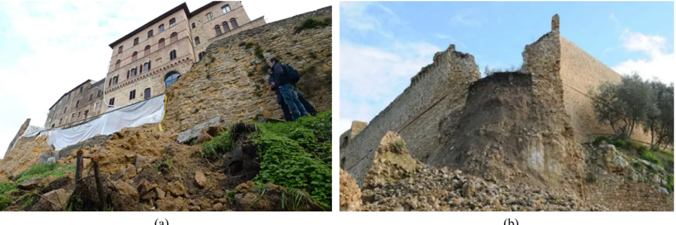
Recent damages suffered by ancient city walls in the region of Tuscany, specifically in the historic towns of Volterra, Magliano in Toscana, Pistoia, Cana di Roccalbegna Pietrasanta, Poggio a Caiano and San Gimignano, expose the growing vulnerability of this heritage of urban fortifications.
The collapse of large masses of earth and important sections of these walls has exposed the urgent need to activate a policy of planned conservation and maintenance for these ancient infrastructures (Fig. 1).
Initially attributed to extreme climatic events, closer study of these phenomena reveals a more complex situation and a pressing necessity to define more effective methods of heritage conservation [1]. This question is extremely important to a region like
Corresponding author: Daniela Ladiana, Arch. Aggr. Prof.
Ph.D. in “Technological Culture and Environmental Design”. Research field: preventive, planned conservation, heritage asset management. E-mail: [email protected].
Tuscany, home to such a significant palimpsest of ancient territorial defense and control systems. Many of these structures—whose typologies range from city walls to castles and fortresses to control towers and coastal fortifications—are now in a state of decay and in need of restoration works, adaptive reuse projects and general programs for their valorization. The need to carefully preserve these structures is linked not only to their definition as monumental heritage, but also to their important role as symbols of the region’s urban and territorial landscapes and society.
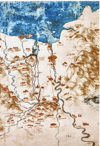
Historic city walls and ancient infrastructures allow for multiple interpretations of place—landscape and culture, identity and community, signs and values, meanings and perceptions; as containers and bearers of memory, identity, art and history they strongly connote territories and landscapes (Fig. 2).
Today, with an urgency that can no longer be ignored, the fields of research and experimentation are asked to identify processes for ensuring the material
D
(a) (b)
Fig. 1 Effects of the collapses on the Walls (a) of Volterra in 2014 and (b) of Magliano in 2012 (Linda Giresini ph.).
survival of these monuments and for maintaining the values they represent.
Clearly, understanding these ancient defensive structures requires an in-depth historical-cognitive study to comprehend the various phases of their construction and the diverse techniques employed over time to modify, repair and modernize them and important conservation and valorization works [2]. However, in primis, it is necessary to define more effective monitoring processes and methods to ensure the timely recognition of eventual conditions of risk by understanding above all the interaction between these historic constructions and their surroundings.
Questions of “what to do and how to go about” preventing these collapses, in the short and long term, were thus adopted as fundamental themes of the multidisciplinary research “Monitoring City Walls—Technologies, Methods and Tools for Conserving City Walls” being developed by the Department of Engineering for Energy, Systems, the Territory and Constructions (D.E.S.Te.C.) at the University of Pisa. The research aims to identify innovative approaches to planned conservation and, in particular, to understanding factors of risk.
To ensure the protection and conservation of ancient city walls, this evidently multidisciplinary research focuses on activating processes designed to halt, or at least slow, deterioration and prevent risks inherent to the relations between these constructions
and their surroundings [3, 4].
The studies and experiments conducted as part of the research were also approached with the logic of a progressive implementation, via the D.E.S.Te.C., of a multidisciplinary laboratory for the planned conservation of monuments operating at the regional and national levels. The intention is to provide services inspired by the experiences of the Europe-wide research Monumentenwacht (Monument Watch), which has produced important results by applying the principles of planned conservation of historical-architectural heritage in the form of periodic inspections.
2. Preventive and Planned Conservation:
The Importance of Knowledge
The “Monitoring City Walls—Technologies, Methods and Tools for Conserving City Walls” research focuses on defining innovative methods and tools for optimizing the preventive and planned conservation of the city walls present in a specific territory.
Preventive and planned conservation is a methodology for protecting historic architectural heritage, founded on the attentive identification of situations of risk and the systematic planning of minimally invasive maintenance. The objective is to access the evident economic and cultural benefits of an approach able to avoid/postpone important restoration works [5].
Fig. 2 Walled cities on the Arno river. Representation of Leonardo, sheet of the RL 12683 Charter of Windsor.
The proposed methodology defines criteria and procedures for developing, programming and implementing the maintenance of monumental architectural heritage based on two fundamental dimensions: duration, through the maximum possible containment of processes responsible for the deterioration of these constructions and their physical integrity, and safety, through the prevention of all possible risks threatening a monument.
This technology implies a systemic approach to the organization of processes, at both the territorial scale and the more minute scale of individual components, to prevent all possible risks faced by a specific construction. The pillar of this technology is founded on the comprehension of each specific construction together with its context, coupled with an understanding of the evolution of inherent dynamics of deterioration and/or possible damages [6].
In this context knowledge is of absolute importance. To favor a systemic approach, the process of planned conservation postulates the initial and progressive periodic acquisition of knowledge about the construction being studied—specifically the technologies, tools and materials used to build it—together with its evolutions over time and the conditions of risk associated with its urban and territorial setting.
Conservation requires a culturally and scientifically backed critical judgment founded on a reading and interpretation of the object to be conserved and the phenomena to which it is subject. The correctness of this judgment is directly correlated to the quality of available knowledge; what is more, it is fundamental that this action be repeated periodically—in relation to the evolution of intrinsic and extrinsic factors—in order to define/update intervention strategies and methods of programmed conservation [7].
The study and analysis of a particular object and its context, as well as the control of natural or pathological processes of deterioration, are indispensable supports to any activity of planned maintenance/conservation. By allowing for an in-depth understanding of the object of study they make it possible to forecast—and thus prevent—the evolution of conditions likely to cause deterioration or damages [8].
Any conservation project must be founded on scientific data acquired using the most appropriate tools offered by state-of-the-art technologies. A similar approach must consider the interdisciplinary nature of a problem that extends into the fields of chemistry, physics, biology, geology and information technologies. The need to understand and document historic heritage involves a broad spectrum of characterizations of different elements, parts, dynamics and relations [8]. This in turn presupposes the implementation of multidisciplinary studies whose results should aid the certain identification of the necessary conservation works. Examples include
static and structural reinforcements, the integrity of building components and materials and, where possible, the reduction/elimination of all possible risks linked to a given context.
Acquiring knowledge and generating a constant flow of information requires the adoption of tools and methods for optimizing data acquisition and management. Similar processes can provide effective support when dealing with questions related to the physical and cultural fruition of this heritage, as well as decision-making processes linked to conservation and valorization. The relevance of this issue is directly proportionate to the scale and value of the heritage to be conserved [6].
The problematic situation described by the recent collapses of city walls in various Tuscan cities reveals the urgent need to develop innovative means for improving the efficiency of the acquisition and management of data relative to such a large number of historic constructions at such a vast scale [1].
Achieving this objective means moving from the detailed acquisition and management of information about a single construction to the handling of a discretized quantity of information relative to a large number of different constructions [9].
3. City Walls and Heritage Asset
Management
The effective implementation of the planned conservation of such a large number of monumental constructions spread across a vast territory is linked to the field of Asset Management, or more precisely, strategic heritage management. At this specific phase of study, Asset Management pursues three fundamental objectives:
risk prevention; conservation;
fruition (physical and cultural) [10].
In this case, strategic management tool is provided by a regional agency with its own dedicated management system (The Urban Walls Heritage Asset
Management System—UWHAMS).
The system consists of a regional GIS information platform containing data about the city walls in Tuscany provided at the regional and municipal levels.
The platform offers a multidimensional and cross-scalar reading of the region’s fortifications organized in diverse fields describing:
relations with the territory and topography; construction typology, morphology, technologies and materials;
phases of construction, transformation and possible expansions;
phases of restoration.
A reliable and complete description is fundamental to any conservation project as it reduces the complexity of reality to a complete and univocal model.
The study thus focused on defining methods and instruments for developing online databases linked to geometric and morphological descriptions, the articulation of building components, information about materials, diagnostic analyses and studies, the cataloging of pathologies and various types of archives. The intention is to describe Tuscany’s city walls at the urban scale and their position in the territory.
The fundamental theme of the search for innovations to the planned conservation of historical-architectural heritage is intended here as the conception and implementation of tools for managing and controlling the conservation process. These tools should help increase operative capacity by fostering the transfer and sharing of data between different territorial operators. This objective is pursued through the ideation of advanced and integrated tools in a GIS environment [11].
Diverse and more or less detailed typologies of information are linked to different scales of visualization in GIS. The system provides general consultable information at a territorial scale and at the
more detailed level of individual constructions. The descriptions of city walls change with each shift in the scale of mapping. The study developed methods for comparing levels of investigation with each different level of geographic data. The result is a systematic database of digitalized knowledge that includes technical information useful to any project for the management and conservation of ancient city walls. Furthermore, differentiated levels of user access ensure that the database also serves other uses (tourism, study, networks of city walls, etc.) [12].
The ancient city walls of Tuscan settlements are not described in an abstract and isolated manner, but together with their surrounding urban and environmental contexts. The latter are not only considered the source of possible risks, useful to any evaluation, but also as opportunities for developing improved conditions for the use, conservation and valorization of historic city walls and their relative spaces.
The platform was created to contain and organize not only the variety of information indispensable to the scientific and technical aspects of planned heritage conservation, but also to promote conservation by disseminating results as projects are progressively implemented. The initial target group is the research community and, successively, the various towns involved.
Information and Communication Technologies (ICT) aid the comprehension, perception, promotion and use of these ancient infrastructures. For the present study, the phase of “Knowledge” describes an analytical process of identifying signs and layers sedimented over time. Clearly, this information is required to activate a process of care intent on guaranteeing the survival of these physical testimonials. Additionally, it also provides new knowledge indispensable to the development of projects for this heritage that are respectful of both its authenticity and integrity and intent on improving its characteristic as a resource for future generations.
The strategic management of risk prevention for
Tuscany’s ancient city walls is based on a digital mapping tool served by a database continually fed by new data acquired through remote satellite surveying.
4. Satellite Interferometry
In recent years, remote sensing has developed into a technology with constantly expanding international applications for territorial studies and monitoring: from environmental monitoring to risk analysis to planning. Satellite monitoring and parametrization processes are now used to program urban development, to evaluate damages caused by calamitous events such as earthquakes and to monitor water reserves, permafrost and many other environmental resources. Various applications developed in recent years have demonstrated the utility and versatility of these technologies for monitoring diverse environmental, geotechnical and engineering-structural conditions. They have proven particularly useful in situations requiring continuous monitoring, for example during an emergency, under poor atmospheric conditions or when an area is difficult to access.
The research presented in this paper focuses on a specific field of application: monitoring dynamic phenomena at the territorial scale and tracking deformations and vertical-horizontal movements in portions of the earth’s crust.
Satellite radar technologies can measure movements in the surface of the earth with millimetric precision using “interferometric” data.
Current technologies make it possible to remotely and continually survey, at an interval of a few hours, “rapid” movements in the ground’s surface caused by episodic and sudden events.
Examples include collapses or “slow” movements such as those related to the compaction of the earth produced over time by a building.
These movements, more or less pronounced, can be charted not only in relation to the ground, but also with respect to other elements, both manmade and natural, located on the surface.
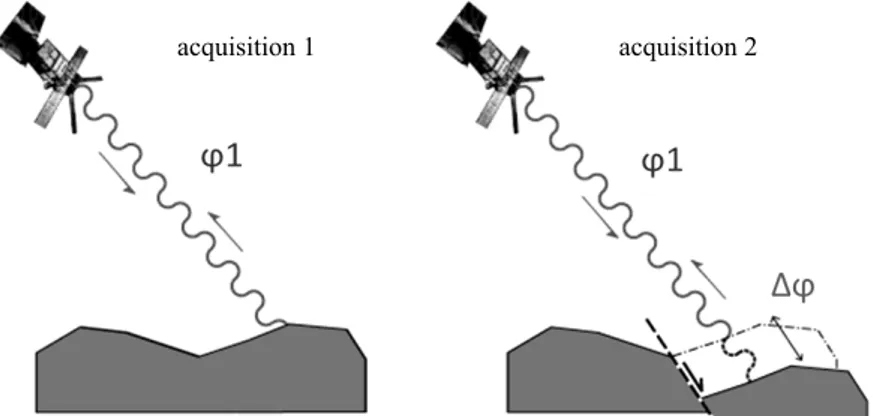
Fig. 3 Satellite interferometry measures phase variations between two signals acquired by a satellite at the same point.
The satellite passes over a point acquiring a signal whose phase depends on the distance between the sensor-target, at a given moment. When the surface of the earth moves, the sensor-target distance increases and, as a consequence, the phase is subject to a measurable variation (Linee guida per l’utilizzo dei dati interferometrici del geoportale Regione Toscana).
Progressive evolutions in the capacity to acquire and process data have expanded the field of application of satellite monitoring technologies from portions of the territory to areas and elements at increasingly higher levels of detail, from architectural and archeological sites to single buildings [13, 14].
In only a decade this technology has passed from low resolution imagery, at 30 m, typical of ERS 1/2 and Envisat satellites sent into orbit between 1991 and 2002 by the European Space Agency (ESA), to the spatial resolution of pixels on the ground up to 1 m, guaranteed by the latest generation of radar satellites, for example those belonging to the COSMO-SkyMed constellation managed by the Italian Space Agency.
Synthetic Aperture Radar (SAR) Satellite Interferometry is a technology for monitoring movements, which consists in the combination of multiple radar images acquired as transmitting and receiving antennas move along a predefined orbit.
The satellite identifies an electromagnetic target (detection) and, by measuring the phase between the signal emitted and that received, evaluates the distance (ranging) to the target, along the direction of the antenna (range direction) (Fig. 3).
The “Monitoring City Walls” research utilises data obtained through SAR satellite interferometry, provided by the Geo-Portal operated by the LaMMA Consortium. The data were used to create an
experimental digital mapping tool capable of operating at the both the regional and urban scale in GIS format, supplied by a continuous flow of satellite data [15].
The map, which uses a chromatic code, was created to survey, record and describe the movements of city walls and their relative context to reveal eventual
deviations—increased excursions or accelerations—from expected seasonal movements. It
is important to emphasize that movements of infrastructures, and their speed, linked for example to cycles of groundwater at various times of the year, were calculated based on the retrospective analysis of historic remote sensing data available on the geo-portal and dating back as far as 2014.
The digital mapping tool developed to corelate data (precipitation, aridity, existing infrastructures and movements) and provide a Decision-Making Support to ensure the timely prevention of possible risks (hydrogeological or deriving from ruptures in underground infrastructures) relative to city walls is already sufficiently reliable as it is based on “retrospective monitoring” implemented through the analysis of pre-existing data.
Data interpretation was based on the comparison and integration of geological, hydrogeological and geomorphological data to gain a better understanding of the territory in relation to the city walls.
The research evaluated a series of limitations, linked principally to the intrinsic characteristics of the surveying technique and the nature of the information, which does not provide all components of possible movements, but only those parallel to the angle of acquisition of the interferometric image.
The data were interpreted in a GIS environment by comparing satellite data and available ancillary data, such as:
multi-temporal orthophotos to evaluate changes over time to a particular area;
products derived from the digital elevation model (DEM) to comprehend the entity of the real movement effectively measurable by the satellite;
a catalogue of landslide events to compare the spatial distribution of survey points with pre-existing catalogues.
The dataset was obtained by elaborating images acquired by the Sentinel-1 constellation of satellites managed by the European Space Agency (ESA), using the PSInSAR SqueeSAR (Permanent Scatterer Interferometric Aperture Radar) method.
5. Conclusions
The “Monitoring City Walls” research aims to develop innovative tools for optimizing the planned conservation of ancient city walls and effective and efficient methods for preventing possible damages to this regional heritage. The tools proposed must also consider all of the assets of these urban fortifications, visible in a broad territory and linked to a specific local situation. This structuring of the research led to the development of a management platform providing different functions at different levels: strategic (regional), tactical and operative (municipal and local entities).
The intention is to support decision-making processes involving the Region of Tuscany’s heritage using data that support conservation and, in particular, the critically important process of monitoring. As the efficiency of any approach to conservation is directly
proportional to the promotion of heritage in relation to its specific context, the platform can also support knowledge acquisition as well as cultural and functional fruition and valorization. The strategic management of the internal spaces and open areas adjacent to ancient city walls will permit these assets to function as catalysts of urban renewal and support the development of scenarios for new uses unique to each specific condition. Thanks to the progressive implementation of data by local entities, the GIS platform and its relative databases can evolve from tools of risk prevention to systematic supports for the strategic management of ancient urban fortifications, oriented toward the economic, social and cultural development of a territory. The documentation of city walls provides a base for defining management strategies with a progressive factor of innovation. At the same time, they also promote a widespread awareness of the value of this heritage and improvements to conservation and maintenance projects by sharing successful practices.
The continuation of the research by the team in Pisa will further define innovative tools for planned conservation by extending the value of the GIS data through its integration with Heritage Building Information Modelling, to visualize and analyze other structures located in the contexts of study. The integration between BIM and GIS may in fact consent a more in-depth and relational vision of phenomena of risk, improving decision-making, communications and knowledge in the field of heritage conservation.
Acknowledgments
Thanks to Jacinto E. Canivell Garcia De Paredes, Emilio Jose Mascort Albea and Rocio Romero Hernandez at the University of Seville for the support provided in defining the digital mapping instruments.
References
[1] Andreini, M., De Falco, A., Giresini, L., and Sassu, M. 2015. “Recenti eventi di crollo in mura storiche urbane.” Presented at AAVV IF CRASC’ 15—III Convegno di
Ingegneria Forense—VI Convegno su crolli, affidabilità strutturale, consolidamento, Sapienza Università di Roma.
[2] Petzet, M., and Ziesemer, J. 2007. Heritage at Risk. ICOMOS World Report 2006/2007. Monuments and Sites in Danger, edited by Reinhold, E. Altenburg: Verlag. [3] Legislative Decree 22 January 2004. n. 42. Codice dei
beni culturali e del paesaggio, ai sensi dell'articolo 10 della legge 6 luglio 2002, n. 137. Article 29.
[4] Canivell, J., Reyes Rodríguez-García, A. M., et al. 2020. “Assessment of Heritage Rammed-Earth Buildings. The Alcázar of King Don Pedro I (Spain).” Journal of Architectural Engineering. https://doi.org/10.1061/(AS CE)AE.1943-5568.0000400.
[5] Gasparoli, P. 2013. “Monitoraggio, diagnostica e prevenzione del degrado.” In Proceedings of the Convention La manutenzione programmata dell’edilizia di culto.
[6] Ladiana, D., and Di Sivo, M. 2019, Le mura urbane crollano. Conservazione e manutenzione programmata della cinta muraria dei centri storici. Pisa University Press.
[7] Germanà, M. L. 2014. “Conoscenza, Conservazione, Valorizzazione: Criticità, Processi e Approccio Unitario.” In La strategia della Conservazione programmata. Dalla progettazione delle attività alla valutazione degli impatti. Proceedings of the International Conference Preventive and Planned Conservation Monza, Mantova, edited by Della Torre, S.
[8] Gasparoli, P. 2012. “La manutenzione preventiva programmata del patrimonio storico come prima forma di valorizzazione.” Techne. Journal of Technology for
Architecture and Environment 3: 48-57.
[9] Della Torre, S., ed. 2003. La conservazione programmata del patrimonio storico architettonico. Linee guida per il piano di manutenzione e consuntivo scientifico. Milano: Guerini e associati.
[10] Ladiana, D. 2008. Pianificazione della gestione e manutenzione delle infrastrutture urbane, L’approccio top-down e bottom-up. Firenze: Alinea Editrice.
[11] Canivell, J., Jaramillo-Morilla, A., Mascort-Albea, E., and Romero-Hernández, R. 2020. “Methodological Framework to Assess Military Rammed-Earth Walls. The Case of Seville City Ramparts.” In Science and Digital Technology for Cultural Heritage. London: Taylor & Francis Group, 83-7.
[12] Petronela, S., Ursu, A., and Sandu, I. 2016. “Heritage Management Using GIS.” In Book 2—Informatics, Geoinformatics and Remote Sensing—Conference Proceedings.
[13] Santana Quintero, M., Anouk, J. M., Stulens Alonzo, C., and Pletinckx, D. 2008. Monitoring Monuments: A Low-Cost Digital Early Warning System for Preventive Conservation of Built Heritage. The Interactive Institute AB.
[14] Carlucci, R., Di Iorio, A., Placidi, A., and Pichini, M. 2011. “WHERE Monitoraggio di Siti Archeologici da Satellite.” Archeomatica 2 (3).
[15] Mari, R., et al. 2019. “Monitoraggio radar satellitare delle deformazioni del terreno della Regione Toscana. Il sistema informativo e la rappresentazione dei dati.” Presented at Conference: XXIII Conferenza Nazionale ASITA, Trieste, Asita.