POLITECNICO DI MILANO
Faculty of Building Engineering, Master of Science in Architectural Engineering
A Community Commercial Center for City of Monterrey,
Mexico
RELATORE: PROF. MASSIMO TADI
THESIS PROJECT BY:
MONA BOUDAGHIMALIDAREH 771406 ACADEMIC YEAR 2014 2015
Abstract
This project deals to design of a commercial center which is situated in most popular and commercial areas of the city Monterrey, N.L, México.
The project is an extension of the commercial center “Paseo Tec” (Hotel, conventions center, Retail Area, parking space, and a direct entrance to ITESM University) which is positioned in front of the site.
The idea was to design commercial center in one way similar to the existent one but at the same time making some difference in the way that it has been planned, taking care of the urban part and also making it somehow more sustainable.
So, in order to meet the requirements, in the urban design part, we proposed some proposal of bike network and developed the avenue beside of the site.In addition, we improved some key points to reach better and more integrated green public spaces by green corridor. Lastly, the master plan is suggested.
On the other hand, the architectural design of the project is consisting of three major parts, i.e. design of the hotel, retail and office area. Also, an area of a big underground parking space has been created. Furthermore, the utilizing of sustainable material and techniques and also using natural light and ventilation have been applied.
Acknowledgments
I am very grateful to the Professor Massimo Tadi, who made this thesis possible. He shared with me an extraordinary amount of Information, knowledge and experience. In addition, I wish to express my love and gratitude to my beloved family for their understanding and endless love.
Finally, thanks to my dear friend Ilnaz Ashayeri for her kindness and help throughout this journey.
Contents
Chapter One Introduction
1.1 Introduction ………..6
Chapter Two Urban Design
2.1 Site History and Characteristics ……….72.2 Socio and Economic Aspects ……….18
2.3Renewable Energy ………26
2.4 Transport ………28
2.5 Green Areas in Monterrey………..33
2.6 Land Use and Zoning Layers ……….42
2.7 SITE AREA ZONING ………. 44
2.8 Urban Analysis in respect to project ………..47
2.9 SWOT Analysis ………...51
2.10 Urban Proposal ……... ………52
2.11 concept and master plan………..55
Chapter Three Architectural Design
3.1 Architecture ……….57
3.2 Requirements ……….58
3.3 Design Concept ……….60
3.4 Architectural Drawings and Renders ……….66
Chapter Four Technological Design
4.1 climate analysis………734.2 wall layers detail……….94
4.3 Energy produced from the solar panel………97
Chapter One
1.1 Introduction
I developed an existing real site as my final thesis. The site of project is located in the city of Monterrey, N.L, México, is an extension of the commercial center “Paseo Tec” (Hotel, conventions center, Retail area, parking space, and a direct entrance to ITESM University).that would be situated 15 min away from Monterrey´s downtown in one of the most popular and commercial areas of the city, beside of the Avenue Eugenio Garza Sada. This area is really well known due to the ITESM University (Instituto Tecnológico de Monterrey) that is located in this avenue.
For the final thesis several requirements of the project have been developed, staring with a wider approach to the urban study zone, and ending with a detailed design of the commercial center. As a process to include separate but integrated study topics, such as urban design, architectural design, technological design. The project confirmed by: offices spaces, Retail
areas, green areas connected to the park and to the Paseo Tec.and also is an extension of the commercial center “Paseo Tec” (Hotel, conventions center, Retail area, parking space, and a direct entrance to ITESM University).
Chapter Two
Urban Design
To be able to define the basic features of the project site, it is required to know the geographical location of it. Thus, the context analysis starts from general information about the country where the project site is situated to very specific information about the site including the resources, socio-economic profiles, local social problems, existing urban forms and services nearby the site, linkages to main roads, etc.
2.1. Site History and Characteristics
Mexico
Mexico, officially the United Mexican States is a federal constitutional republic in North America. It is bordered in the north by the United States of America; in the south and west by the Pacific Ocean; in the southeast by Guatemala, Belize, and the Caribbean Sea; and in the east by the Gulf of Mexico. Covering almost two million square kilometers, from which only 2.5% is water, Mexico is the fifth largest country
in the Americas by total area and the 13th largest independent nation in the world. With an estimated population of over 113 million, it is the world's eleventh most populous country and the most populous Spanish-speaking country. The capital is Mexico City situated in the southern part of Mexico. In the picture can be seen the population density. Towards south, the density increases. Nuevo Leon county, where Monterrey city is located, has a higher density than the surrounding areas, the population reaching 4.5 million inhabitants. The capital has the highest density in the country with a population around 10.5 million inhabitants.
Monterrey
The city is anchor to the third-largest metropolitan area in Mexico and is ranked as the ninth-largest city in the nation. Monterrey serves as a commercial center in the north of the country and is the base of many significant international corporations. It is Mexico's second richest city, and the world's 63rd richest, with an economy that had a 2008 GDP of USD $102 billion. Monterrey is one of Mexico's most developed cities, with the highest per capita income in the nation, and is regarded as a highly developed city. Rich in history and culture, Monterrey is often regarded as the most "Americanized" city in the entire country, even above the cities along the U.S-Mexico border.
Technologic district (the location of our site), which is also the place of an important Mexican university is situated in southern part of Monterrey, but close to center. By developing a new shopping center always creates problems dealing with the surroundings. There will be many problems related to traffic jam, pollution, street vendor activities around mall, to pedestrian or to traffic regulations. So, it will be an
opportunity for us to practice and improve our implementations regarding the urban development in the region in order to find a solution to these problems. In order to make a proper assessment, at that point, it is necessary to understand the development pattern of the urban spaces throughout history and see how the urban development expanded until our site. The conditions, reasons and motivations of this expansion should be searched in history.
Early History
Anthropological and archeological evidence suggests that early nomad hunters and gatherers arrived in the area now known as Nuevo Leon as early as 8900 B.C. The state’s primary source of pre-Hispanic relics near Mina has yielded over 1,000 engraved stones dating from 1350 to 650 B.C. Evidence suggests that as many as 250 indigenous tribes may have dwelled near Monterrey, Cadereyta and Cerralvo, including the Amapoalas, Gualiches and Gualeguas. When the Spaniards arrived in the early 16th century, Nuevo León was devoid of large settlements. Most of the natives were still nomadic and traversed the unfriendly Nuevo León terrain on their way to other regions.
Middle History
The first Spanish conquistadors to visit present-day Nuevo León were Alvaro NuñezCabeza de Vaca around 1535 and Andrés de Olmos a decade later. Alberto Del Canto entered the area in 1575 and discovered a valley that he named Extremadura; the city of Monterrey was later built there. Further north, de Olmos also found
mineral deposits at San Gregorio.In the early 1600s; Spanish Governor Diego de Monte mayor led a new colonization effort in the area. He was joined by Franciscan priests who began converting the indigenous population to Catholicism. By the late 17th century, colonization efforts had been mostly abandoned.
A brief mining surge in the mid-1700s resulted in the discovery of gold and silver in the area. These deposits were rapidly exhausted, and interest and activity diminished quickly. Taking advantage of large land entitlements given to the church, Catholic convents and seminaries were built in the region during the late 1700s.
Recent History
In 1811, the independence movement caught on briefly in Nuevo León. After the execution of the popular and powerful priest and revolutionary Miguel de Hidalgo y Costilla, rebellions in the area were brought to a halt. Forces loyal to Spain regained control of the entire region, and it wasn’t until after the Plan of Iguala in 1821 that Nuevo León became a province of independent Mexico. In 1824, it became a federal state and a new constitution was adopted.
The rest of the 19th century was marred by political instability and fighting. Conflicts between centralists and federalists and a civil war between liberals and conservatives prevented economic development of the region. The continuous fighting caused social order to deteriorate in Monterrey and other towns. After Mexico ceded its northern territories, including Texas, to the United States, a liberal regime was established that helped bring about much-needed economic development. However, low population density remained a problem for Nuevo
León. Towards the end of the 19th century, a new railroad between Mexico City and Monterrey helped promote industrialization.
Nuevo León was an early supporter of the Mexican Revolution. In 1910, revolutionist and presidential candidate Francisco Indalecio Madero were arrested in Monterrey after being accused of fraud by incumbent president PorfirioDíaz. The ensuing protests grew into a revolution later that year, and the revolutionaries eventually gained control of Nuevo León. The state participated in the writing and promulgation of the Mexican Constitution of 1917. After the end of the revolution, Nuevo León became a cattle ranching state, and Monterrey solidified its position as the most important industrial and financial center in northern Mexico.
A brief history about urban development
Mexican cities typically developed around a historic core. The historic core of Mexican cities included government offices and civic buildings, a transportation network centering in the core, several historic churches and a plaza or gathering space all placed over a tight grid street system. The historic core in Monterrey was defined by the development of the built environment up until 1922. By 1922 these characteristics of the core were well-established. The area is made up of 31 AGEBS, a geographic unit similar to a Census Tract in the US developed by the Instituto Nacional de Estadistica y Geografia (INEGI) for the national Mexican census.
Following the development of the historic core was the expansion of what would become the Inner Urban Areas (INURBAS). Development beyond the core began in 1923 and continued through 1950. This period was selected because it was after 1922 that the historic core was well-established and the city began to grow outward. The INURBAS were made up of 181 AGEBS. These areas were located immediately following the historical core in the second ring.
Monterrey historic core 1922
Monterrey grew rapidly between 1950 and 1980. The city was a center of economic activity and population growth. As the population and economy grew from the 1950’s through 1980, the city’s physical structure also expanded. Although much was being built throughout this period, one area that lagged relative to the rate of population growth was residential housing for the working class. The flourishing industry here, attracted thousands of migrants from other regions in Mexico. In Monterrey many workers took the housing problem into their own hands.
The first traditional slums that were located just outside the INURBAS began to appear in the
1950s. They share the common characteristic of being an unplanned solution to the housing
problems of the poor. Unplanned means they were created without the authority of government or private developer. These settlements were often known as “squatters” because poor families who could not afford to buy land or homes found empty lots outside the city and began to build self-help housing. The phenomena occurred widely in Latin American cities throughout the 1970s.
Over the years, many squatter settlements were consolidated into working class neighborhoods and have experienced a certain level of economic growth. Local governments have extended land titles to the original squatters who then became owners of the land. These households were defined as the Innerburbs. The Innerburb ring is not homogenous, and contains an array of social, demographic and economic diversity. The initial boundary delimiting the Innerburbs was based on development of the built environment and was the first step to specifying the study area.
Inner Urban Areas (INURBAN) 1923-1950
Inner Urban Areas (INURBAN) 1951-1980
In the figure on the left it is shown how has expanded Monterrey Metropolitan area during the specified period of time. Starting from the historic core the city expanded gradually around it. The different gradients of grey indicate the development in a specific period starting from the 40’s.
Geography
The city of Monterrey is 540 meters (1,770 ft.) above sea level and located in the northeastern Mexican state of Nuevo León. The Santa Catarina River—dry most of the year on the surface but with flowing underground water—bisects Monterrey from East to West, thus separating the city into north and south halves, and drains the city to the San Juan River and Rio Grande.
Monterrey is adjoined to San Nicolás de los Garza, García and General Escobedo to the north; Guadalupe, Juárez andCadereyta Jiménez to the east; Santiago to the south; and San Pedro Garza García and Santa Catarina to the west.
Monterrey lies north of the foothills of the Sierra Madre Oriental mountain range. A small hill, the Cerro Del Topo and the smaller Topo Chico are located in the suburbs of San Nicolás de los Garza and Escobedo. West of the city rises theCerro de lasMitras (Mountain of the Mitres), which resemble the profile of several bishops with their mitres.
Cerro de la Silla (Saddle Mountain) dominates the view east of the city. Cerro de la Loma Larga—South of the Santa Catarina Riverseparates Monterrey from the suburb of San Pedro Garza García. At the summit of the Cerro delObispado, north of the river, is the historic Bishopric Palace, site of one of the most important battles of the Mexican-American War.
Urban expansion 1940-2005
Climate
Designing of a building has to be in close relationship with climatic context. It is not possible to create buildings and spaces without considering the climatic conditions. Especially for a sustainable design, where the impact on environment is required to be kept minimum, under-standing the climate of the project area constitutes a crucial step at the very beginning of the design process.
Location: 25°40′N 100°18′W Altitude: 534m
Average temperature: 22.3 C
Warmest average max/high temperature: 34 C Coolest average min/low temperature: 10 C Precipitation average: 620 mm annually Average relative humidity: 65.3 %
Average sunshine: 2072 h annually and 5.7 h of sunlight daily Average snowfall (>1cm): 0
Prevailing wind direction: E, S-E Average wind speed: 4 m/s
Climate data for Monterrey (1951–2010)
Sun
It is understood that the city of Monterrey is situated in the northern hemisphere of Earth. During the day the sun tends to rise to its maximum at a southerly position. This information is highly significant for decisions regarding the orientation of the building blocks. The relative position of the sun is a major factor in the heat gain of buildings and in the performance of solar energy systems. Accurate location-specific knowledge of sun path and climatic conditions is essential for economic decisions about solar collector area, orientation, landscaping, summer shading, and the cost-effective use of solar trackers.
Wind
Knowing about the prevailing wind direction and the average wind velocity, the designers have an idea about the effect of the wind in daily life; can decide on whether to use the wind a source of energy, etc.. In this project, wind will not be considered as a source of energy. For high rise buildings, tunneling effect must be considered.
Stereographic Diagram
Over the course of the year typical wind speeds vary from 0 m/s to 8 m/s (calm to moderate breeze), rarely exceeding 12 m/s (strong breeze). The highest average wind speed of 4 m/s (gentle breeze) occurs around June 11, at which time the average daily maximum wind speed is 8 m/s (moderate breeze). The lowest average wind speed of 2 m/s (light breeze) occurs around September 11, at which time the average daily maximum wind speed is 6 m/s (moderate breeze).
The wind is most often out of the east (16% of the time) and south east (13% of the time). The wind is least often out of the south west (1% of the time), south (1% of the time), north east (2% of the time), west (3% of the time), and North West (5% of the time).
Humidity
The relative humidity typically ranges from 33% (comfortable) to 93% (very humid) over the course of the year, rarely dropping below 14% (very dry) and reaching as high as 100% (very humid). The air is driest around April 5, at which time the relative humidity drops below 42% (comfortable) three days out of four; it is most
humid around September 12, exceeding 91% (very humid) three days out of four. In
general relative humidity is within comfortable range (30%-70%).
Wind speed Wind direction
Temperature
In order to be able to provide thermal comfort in the building to be designed, average, maximum and minimum temperatures observed in the area of intervention should be known precisely and should be employed in related calculations. Having quite a high average annual temperature, the heating load will be low during the cooler months, but will be compensated with a high cooling load during the hot months. Solutions for better and more effective cooling must be found.
Over the course of a year, the temperature typically varies from 9°C to 37°C and is rarely below 4°C or above 40°C. The warm season lasts from April 29 to September 5 with an average daily high temperature above 34°C. The hottest day of the year is June 18, with an average high of 37°C and low of 24°C. The cold season lasts from November 22 to February 19 with an average daily high temperature below 25°C. The coldest day of the year is January 3, with an average low of 9°C and high of 22°C.
Relative humidity
Precipitation
The rainfall is very small. Precipitation is most likely around September 18, occurring in 22% of days. Precipitation is least likely around March 25, occurring in 11% of days. Rain water may be collected for some utilitarian purposes and accordingly it may fall into the scope of urban and architectural design.
Precipitation is most likely around September 18, occurring in 22% of days. Precipitation is least likely around March 25, occurring in 11% of days. Over the entire year, the most common forms of precipitation are drizzle, light rain, and moderate rain. Drizzle is the most severe precipitation observed during 46% of those days with precipitation. It is most likely around February 2, when it is observed during 13% of all days. Light rain is the most severe precipitation observed during 23% of those days with precipitation. It is most likely around September 18, when it is observed during 9% of all days. Moderate rain is the most severe precipitation observed during 19% of those days with precipitation. It is most likely around September 1, when it is observed during 6% of all days.
2.2 Socio and Economic Aspects
Population
In 1950 Monterrey’s population was 339,282 inhabitants , representing 45.8% of the total state population of Nuevo Leon. This urbanization of the state population was mainly based on the displacement of immigrants who were seeking better living conditions in the city. The urban growth spread approximately in 6,467 hectares
including municipalities such as San Pedro, San Nicolas, Guadalupe, Escobedo, Santa Catarina and Apodaca. Twelve percent of the urban area was dedicated to industrial activities and there were more than 750 industries. In that year, 46% of Monterrey’s economically active population was employed in the manufacturing sector. Currently, the manufacturing sector employs only 26.9 % of the economically active population.
In 1984 the Monterrey Metropolitan Area- MMA was created. MMA initially included the municipalities of Monterrey, Guadalupe, San Nicolás, San Pedro, Santa Catarina, Escobedo, Apodaca; García and Juárez were more recently included. The total MMA population was 2,011,936 inhabitants, which corresponded to 80% of the total State of Nuevo Leon population. By 1990s Monterrey’s metropolization was a fact. With a population of 2,573,527 inhabitants, the automobile became the main transportation mode. By 2000 MMA population was more than 3 million. Currently MMA provides a high standard of living to its residents and is considered one of the most developed regions within the country.
0 500000 1000000 1500000 2000000 2500000 3000000 3500000 4000000 4500000 1950 1960 1970 1990 1995 2005 2010
Population growth
19From 1970s to 1990s the Monterrey Metropolitan Area (MMA) becomes almost completely urban. As a consequence of this urbanization, in 1995 less than 5 percent of the MMA population lived in rural areas compared with 25 percent in the national level. This is an important trend when consider that poverty
levels have historically been higher in rural than in urban areas. In 2002 for example, the extreme poverty line was 35.23% in rural areas, while it was 7.5% in urban areas; in the national level 14.4 of households were in extreme poverty.
The urbanization process has resulted in a higher concentration of Nuevo Leon population in the MMA. In 2000s MMA shows a relatively well distributed population. However, according to density levels, there are higher levels of population concentrated in San Nicolas (5,709) and Guadalupe (4,420), and very low
ones in Juarez (238), Santa Catarina (230), and Garcia (33). As a consequence of this high density, currently 70.2% of the total MMA population is concentrated in Monterrey (34.2%) Guadalupe (20.7%) and San Nicolas (15.3%).
Economy
Monterrey is a major industrial center in northern Mexico, producing a GDP of 78.5 billion US dollars (2006). The city's GDP per capita in 2010 was 607,042 Mexican pesos or $46,634 US dollars. The city was rated by Fortune magazine in 1999 as the best city in Latin America for business and is currently ranked third best by the AméricaEconomía magazine.
The city has prominent positions in sectors such as steel, cement, glass, auto parts, and brewing. The city's economic wealth has been attributed in part to its proximity with the United States-Mexican border and economic links to the United States. Industrialization was accelerated in the mid-19th century by the CompañiaFundidora de Fierro y Acero Monterrey, a steel-processing company. Today, Monterrey is home to transnational conglomerates such as Cemex (the world's third largest cement company), FEMSA (Coca-Cola Latin America, largest independent Coca-Cola bottler in the world), Alfa (petrochemicals, food, telecommunications and auto parts), Axtel (telecommunications), Vitro (glass), Selther(leading mattress and rest systems firm in Latin America), Gruma (food), and Banorte (financial services). The FEMSA corporation owned a large brewery, theCuauhtémocMoctezuma Brewery (Cervecería Cuauhtémoc Moctezuma) that produces the brands Sol, Tecate, Indio, Dos Equis and Carta Blanca among others, in the beginning of the year Cuauhtémoc Moctezuma Brewery was sold to Dutch-based company Heineken. By the end of the same year, there were more than 13,000 manufacturing companies, 55,000 retail stores, and more than 52,000 service firms in Monterrey.
The metals sector, dominated by iron and steel, accounted for 6 percent of manufacturing GNP in 1994. Mexico's steel industry is centered in Monterrey, where the country's first steel mills opened in 1903. Steel processing plants in Monterrey, privatized in 1986, accounted for about half of Mexico's total steel output in the early 1990s.
Monterrey was ranked 94th worldwide and fifth in Latin America in terms of Quality of Life according to Mercer Human Resource Consulting (2006), and was ranked second in 2005 and fourth in 2006, according to America Economia.
Some of the shopping malls in the city include Paseo San Pedro, Plaza Fiesta San Agustín, Galerías Monterrey, and Galerías Valle Oriente, which distribute goods and services to the Mexican population.
Economic Aspects
The State of Nuevo León generates: • 8.6% of Mexico's GDP.
• 9.4% of manufactured products in Mexico.
Domestic production share of enterprises in Nuevo Leon. Percentage of total production:
• 75% of glass • 75% of corn flour • 70% of household appliances • 60% of synthetic fibers • 60% of cement • 50% of beer • 50% of ceramic products • 25% of steel
In the year 2000, Nuevo Leon attracted 18.4% of foreign direct investment in Mexico. Mainly from the U.S. (70% of total investment), Holland accounted for 11%, Japan for 7% and Canada for 4% respectively.
Top Economic Clusters in Nuevo Leon
• Automotive, auto parts and components • Home appliances
• Electric and electronic equipment • Metal mechanics
• Steel, glass and cement
• Software and Information technology services • Medical services
Culture
The most traditional dish from Monterrey is cabrito, kid goat cooked on embers based on the Jewish cuisine of the founders of the city. Other local dishes and customs that perhaps date back to the Crypto-Judaism of these founders are the "semita" (bread without leavening), the capirotada dessert (a mix of cooked bread, cheese, raisins, peanuts, and crystallized sugarcane juice), and the relative absence of pork dishes. Another famous local dish is machacado con huevo.
Carne asada on weekends remains a tradition among Monterrey families. It is usually served with grilled onions, baked potatoes and sausages or chopped as tacos. Locally
brewed beer and cola are an almost mandatory part of the weekly ritual. The traditional desserts, "glorias" and "obleas," made from goat milk are both traditional candies from Nuevo León.
Nuevo Leon Today
Nuevo León ranks above all Latin American countries in the Human Development Index, a comparative measure of life expectancy, literacy, education and standard of living developed by the United Nations. The state is the third most industrialized in Mexico, and most residents enjoy a comfortable standard of living. One of its municipalities, San Pedro Garza Garcia, has the second highest per capita income in Mexico.
The industrial structure of the state includes oil refining and heavy and light manufacturing. Nuevo León is one of Mexico’s leading producers of iron, steel and chemicals, and Monterrey is home to many large manufacturing companies: Cemex (cement), Bimbo (bakery and pastry), Maseca (food and grains), Banorte (a Mexican-owned bank), Alestra (telecommunications), Vitro (glass), Hylsa (aluminum), FEMSA (Coca-Cola) and Cervecería Cuauhtémoc-Moctezuma (brewers of five beer brands). Nuevo León also has a rich agricultural core, the orange belt, which is made up of the municipalities of Allende, Montemorelos, Hualahuises, General Terán and Linares. While industrial Nuevo León and the orange belt enjoy economic wealth, the southern part of the state (including the municipalities of Galeana, Arramberri, Zaragoza, Doctor Arroyo and Mier y Noriega) remains poor largely due to climatic and geographic conditions that make the area unsuitable for agriculture and livestock.
Manufacturing represents the largest source of the state’s economy at 27 percent. Service-based companies represent 22 percent of the economy, followed by trade at 19 percent, finance and insurance at 15 percent, transportation and communication at 11 percent, construction at 3 percent, agriculture and livestock at 2 percent and mining at 1 percent.
Nuevo León is not only an industrial leader; it also promotes culture and supports the arts. From September through December 2007, Monterrey hosted the United Nation’s Universal Forum of Cultures. Among the state’s museums are the Marco (contemporary art), the Mexican History Museum and the Glass Museum.
Every year, thousands of students from all over the country pour into the capital city to study at the Monterrey Institute of Technology and Higher Education, the University of Monterrey and the Autonomous University of Nuevo León.
Landmarks
The capital of Nuevo León (Monterrey) offers many attractions that are characteristic of the state, such as the Cerro de la Silla (Saddle Mountain), which is the city’s most-recognized symbol. Macroplaza, one of the world’s largest plazas, occupies the center of city. The Palacio de Gobierno (Government Palace) is a pink
marble neoclassical building that houses the governor’s offices. The Catedral Metropolitana de NuestraSeñora de Monterrey is the seat of the local archdiocese. Built over a 100-year period, the cathedral features different interior and exterior architectural styles.
Ecotourism
The state’s natural landscape includes caves, canyons, lakes, waterfalls and mountains, making Nuevo León popular for outdoor activities such as climbing, rappelling and hiking.
The Sierra Madre Oriental--highest peak of which, the Cerro El Potosí, rises more than 3658 meters (12,000 feet)--is partly located in Nuevo León. The Potrero Chico canyon has stone walls that reach more than 762 meters (2500 feet) high and provide some of Mexico’s best recreational climbing walls.
The region around Santiago provides many activities for the adventurous. Once a waterfall, El Salto is ideal for rappelling, with peaks reaching heights of 38 meters (125 feet); some rappelling sites at the Chipitín waterfalls are 61 meters (200 feet) high. The cave system of Potrero Redondo has underground rivers up to 305 meters (1000 feet) long.
Caves
The GrutasGarcía (García Caves), a 16-chamber cave system, can be accessed via a 700-meter (2297 feet) funicular railway. Various formations of stalactites and stalagmites flank the train’s route, and visitors can see fossils of shells and wrinkles on the walls of the cave, which was covered by the sea 50 to 60 million years ago.
Rock Paintings
The Cañón de la Huasteca, located16 kilometers (10 miles) west of Monterrey, is 274 meters (900 feet) deep. Many important prehistoric drawings of humans and animals -- believed to have been created by the Catajunes Indians -- have been found in the canyon.
2.3 Renewable Energy
Renewable energy is energy that comes from natural resources such as sunlight, wind, rain, tides, waves and geothermal heat. About 16% of global final energy consumption comes from renewable resources, with 10% of all energy from traditional biomass, mainly used for heating, and 3.4% from hydroelectricity. New renewable (small hydro, modern biomass, wind, solar, geothermal, and biofuels) accounted for another 3% and are growing very rapidly. The share of renewable in electricity generation is around 19%, with 16% of electricity coming from hydroelectricity and 3% from new renewable.
Despite Mexico’s potential oil boom in the light of its latest energy reforms and the newly approved Hydrocarbons Trans boundary Agreement with the U.S., the country remains invested in its alternative energy resources. Currently, only 7% of Mexico’s energy is from renewable sources. Biomass is in the lead with 3.8%, followed by Geothermal at 1.6% and Hydropower at 1.4%. Finally, solar and wind energy sources are 0.1%.
In 2012, the Mexico Ministry of Energy (SENER) published a report titled Prospects for Renewable Energy 2012-2016. In it, SENER highlights that Mexico had issued over 50 permits in 2012 for generating power from agricultural residue. The report also showed Mexico’s high potential for landfill gas production with approximately 28.2 million tons of solid waste dumped in landfills, of which 53% is organic. Taking into
consideration that 10 permits offered a capacity of 44.76 MW, SENER estimates that Mexico’s 186 landfills can generate between 652 and 912 MW.
Power generated from livestock waste also shows great potential. The 327 anaerobic digesters the Mexican government approved between 2008 and 2012 have successfully processed a variety of waste materials, including pig manure collected from pig farms, dairies and feedlots. Pig manure alone has the potential of generating 246-492 MW.
Complementing the findings of the report is a study initiated by PricewaterhouseCoopers (PwC) to evaluate the sources of biomass in Mexico and determine their potential. According to the study, the capacity of biomass generation can reach 1.5 GW in 2020, which is a substantial rise from the 550 MW produced in 2012. The sources of the 1.5 GW are predicted to be agricultural residuals (950 MW), livestock waste (278 MW), urban landfills (200 MW), and forestry residuals (87 MW). By embracing its biomass potential alone and generating at least 1 GW by 2020, Mexico will be able to add USD 37.5 billion to its GDP, generate 31,000 jobs, and cut down its CO2 emissions by 5 Mt.
Biomass aside, geothermal energy in Mexico offers great energy potential. Ranking fourth worldwide, Mexico’s geothermal power generation is estimated at 7560 MW, of which three quarters is produced at the Cerro Prieto plant in Baja California. Mexico’s 72 operating hydropower stations also contribute highly at 11,603 MW while those under construction promise to add 136 MW. Experts haves identified over 100 possible sites which the government will explore when funds and labor are available.
Despite getting attention much later, solar energy in Mexico is expected to thrive, as the county is one of the top five countries to invest in. By 2013, 33 MW of solar energy was being produced while 39.1 MW was expected from facilities under construction. As for wind energy, the sector remains underdeveloped. Despite offering a potential of 71,000 MW, only 1.7% of it is in use. In 2013, in operation facilities produced 1214 MW while those under construction promised to add 2069 MW.
Based on information from Greentech Media, Mexico offers a great solar energy opportunity. This was confirmed in the Solar Energy Section Report published by Mexico’s energy department SENER. According to the document, Mexico’s solar
insulation is about 5 kilowatt-hours per meter-squared daily, which is almost the same output as southern California. If Mexico is to use 0.06% of its landmass, especially in Chihuahua or the Sonoran Desert, it could cover most of its electricity needs easily.
Globally speaking, the International Energy Agency’s EA Photovoltaic Power Systems Program Annual Report for 2008 indicates that Mexico’s average solar insulation (60%) is more than Germany, which is the current king of solar energy. The only reason the South American country hasn’t been able to catch up is because its solar energy technologies were underdeveloped. However, things are starting to change in the Mexican solar energy sector.
In December 2013, Mexico’s Congress passed amendments to the constitution, creating a ‘free market’ for electric power. One of the amendments now mandates that 35% of Mexico’s electricity be generated from renewable resources before 2024. With the market thriving with opportunities for renewable energy, international companies (Los Angeles-based CSDR International, etc.), are stepping into Mexico to establish joint ventures with local companies.
Other events are also happening, like the Mexico Energy Summit, on September 10 and 11, 2014 at the Hyatt Regency, Mexico City, Mexico, which is expected to focus a big part of electricity discussion in renewable generation, distribution and infrastructure, as Mexico is required to have 1/3 of electricity production from renewable sources by 2024.
With the speed Mexico is going in, solar energy will soon become the top source of electricity in the country.
2.4 Transport
The composition of the metropolitan area of Monterrey, speaking about its form, is explained by the mountains, valleys, streams and rivers that conform they have conditioned the distribution of its road infrastructure. In its most elementary or basic concept, the urban structure of the metropolitan area consists of master or principal roads and urbanized areas that are developed based on these roads.
As natural borders, the topography and hydrology of the Conurbation has historically characterized the image of Monterrey, with its imposing and majestic mountains, rivers and streams, and structures that frame the valleys that make up the urban area.
The existing railways in the metropolitan area of Monterrey, become almost physical barriers of mobility and urban life, considering result as artificial edges. For the location of large and medium industrial enterprises in the center of the metropolis (previously in the periphery), the inputs required and sending products abroad, cause the railroad access them, having to cross urban high density arteries and roads causing traffic disruptions conflicts.
Also, the high structures of lines 1 and 2 of METRO, and currently the expansion of the last one, are considered artificial borders or edges, with high presence in the metropolitan landscape. The Avenues Colón, Simon Bolivar and Universidad are substantially transformed by these structures, altering the urban scale and somehow segregating local activities.
Public Transportation Analysis
Because most of the Nuevo Leon State's population is located in the metropolitan area, it is vital to take into account the current structure of the metropolis, accordingly to restructure the Transportation System, especially in the modality of public transport buses and Metro.
As seen in the chart above, there is a decrease in the preference of public transport and a constant increase in population that moves in private vehicles, this and the strong cultural presence of the idea about using automobile as an element of social status generate much of the inefficiency of public transport.
As shown in the following image, the itinerary of many routes converge in the center of Monterrey, which causes overcrowding of roads. The presence of a high number of units of public transport also causes serious problems in the management of traffic in major sections of the road network of the first frame of the city.
Another important factor is that the road where that transport can transit, have few or no options, since precisely because the urban structure bound by mountains, is the primary radial roads, concentrating in most cases all flow in a single avenue. The efficiency of public transport than private transport is done by car, if you take into account the traveler occupied as the car takes between 10.00 and 12.50 m and 21.50 m area bus, but the bus can travel up to 70 people a car and a maximum of 7 people, what can be deduced that for purposes of the efficient use of the roads, it would be preferably to use public transport or other means of transport as well as METRO cilovías increase in the city for bicycle use.
Public transportation RED:
BUS
Metro
322.5 Green areas in Monterrey
Due to the importance of green areas in the quality of urban areas way of life, the world health organization (WHO) recommends that in each city exists, at least, a 9m2 of green area per habitant.
In general, we can observe a tendency between population growth and the reduction of green areas in the cities that are with a high population. The contact with biodiversity, can be consider as an indicator in the quality of life for the habitants of a determinant area, because of this maintaining adequate green space quality and quantity compared to the rapid growth of urban areas is a major challenge for urban planners.
The importance of green areas in urban zones lies in the benefits that it brings to the resident population, effects that can manifest in various areas of social character, since the creation or development of ecological awareness to the feeling of safety and physical and mental health of the inhabitants.
Situation in Monterrey
Is important to clarify the fact that Monterrey is the largest city and capital of the state of Nuevo Leon, México, in 2010 brought together a total of 1,135,512 inhabitants, and it is also the head of the Monterrey metropolitan area, which includes a total of 4,150,000 inhabitants in 2010. The Different cities of Monterrey metropolitan area are very close to each other so it is very common to refer to all as “Monterrey city”. However for this study has been taken into account only the official area (1´135,000).
According to the study realize by “Roccalti (2004), green areas in Monterrey occupy a surface of 528.168 hectares. This means that there are 4.8 square meters of green area per inhabitant (in the year of the study population was estimated at 1´100,350 inhabitants).
INEGI census study in 2010 gave as result that Monterrey had a population of 1´135,000 inhabitants. The study of green areas conducted by the Faculty of forestry science, UANL in 2013 says that there are 1,838.75 hectares cover by vegetation inside the area of Monterrey.
On a first view if we analyze the satellite image of Monterrey we can note a large area cover by vegetation. However we need to recognize the difference between areas cover by vegetation and green areas.
An area cover by vegetation maybe could not be accessible for the population, a “green area” must be a space in which predominates vegetation and at the same time it provides benefits to the population and the urban environment. In the most common benefits we can mention: Encourage physical activity, social inclusion and a better quality of life for the population, should provide environmental services such as urban temperature control, carbon sequestration, improved air quality, protection of biodiversity, reduced erosion, flood control, energy saving and noise control.
Considering these features only 704.24 of 1838.75 hectares detected initially meet this standard. The rest (1,134.50 He) can only be considered covered by vegetation and areas that are not available for the enjoyment of the population because are private property or has not infrastructure or roads that provide access to them.
Therefore the city of Monterrey has 6.2 m² of green area per inhabitant. This result cannot be interpreted as exceeding 4.8 m² reported by Roccatti (2004) because it
must be noted that most of the green areas are concentrated in the south and west of Monterrey, which makes them practically inaccessible areas for the inhabitants of the center and north of the city. the south (including cannon Huajuco)
contributes to increase the amount of green areas with a 40.63% of all green areas in the city. This area (south) includes: Col. Independencia, GARZA SADA, Lazaro Cardenas, Satellite and Huajuco and this are within the recommended standars by OMS because it has 9.97m² per inhabitant.
The same situation occurs in the west of the city (Cumbres, CumbresPoniente, Cerro de lasMitras y San Jerónimo) which provides 32.49% of green areas and 12.78m² of green area per inhabitant. However, the northern region (Cd.
Solidaridad, Cerro del Topo chico, Mitras Norte, San Bernabé y Valle Verde ) has only 2.63m² per capita, which is well below the international standard. The same applies to the downtown area (Centro, Ind. Moderna, Mitras Centro y Obispado) that count only with 3.48m² per inhabitant.
In recent decades the city of Monterrey has had a more orderly growth than in the past. However, its initial setup and the lack of an initial development plan make it virtually impossible to create new green areas within the city. For this reason, it is proposed to concentrate efforts on increasing the quality of existing green areas in the city center. Also, is important to control the growth of the city to the south and west as the creation of new housing complex and population growth will increase in the coming years, this could make this area to be located below the international standard.
In a city like Monterrey were the weather is so extreme, is very important to think about the type of vegetation that could be used in this area. Throughout the decades, the trees have also had seasons in which certain species have become fashionable. So in the 70 large urban and rural plantations of eucalyptus (Eucalyptus spp.)Were performed. Then followed urban plantations ash (Fraxinusspp), Laurel India (Ficusmicrocarpa), Ficus (Ficusbenjamina), Thunder (Ligustrumjaponicum), all these species are considered non-native, but by rapid growth were chosen without full knowledge of their biology, or the problems of their origin, would bring to the streets, sidewalks, buildings and green areas in general. These trends in reforestation have brought catastrophic consequences when environmental contingencies were presented, as in the case of the cold wave that hit the northern states of Mexico in February 2011, where in cities like Chihuahua were recorded at temperatures below -20 º C, freezing temperatures that ended with all the trees in the city, mostly composed by Eucalyptus. This problem could have been avoided if they had selected native species adapted to the local weather.
The goals to be achieved in terms of green area and number of trees, whereas tree requires an adult to develop properly 16m2 are presented in Table 2.
Table 2.number of mature trees required to achieve 9m2 of green area per inhabitant.
The priority areas for the location of green areas are the north and center of the city. In a comparative way the results of green area per inhabitant in some cities are presented:
Table 3. Cities with more green areas per inhabitant
Table 4. Cities with less green areas per inhabitant
Monterrey has a great potential to locate species of trees, shrubs and creeping plants which can increase the density of green areas in the city like: existing spaces,
medians of avenues, sidewalks, parks, plazas and new areas that have opportunity to be planned / designed with features that become green areas according to international standards.
There are very successful examples where even in small areas such as medians or important avenues have been conducted tree planting projects, such as Calzada and Calzada del Valle San Pedro, in the municipality of San Pedro Garza Garcia, NL (Monterrey metropolitan area) in which the long-lived but even healthy trees, encourages endless recreational activities and outdoor recreation that attracts residents from nearby areas such as Monterrey
Important green areas
1. Macro plaza
The “Gran Plaza” was built in the 1980’s. It is 40 hectares in length and it is considered as one of the biggest plazas in the world. It starts at the “Explanada de los Heroes” where the neo-classical style of the State Government Palace building stands out.
Aroun the Macroplaza we can find several museums such as the MARCO (Contemporary Art Museum), the Government Palace Museum, the Metropolitan Museum of Monterrey, the Mexican History Museum, and many beautiful old
facades inside the Barrio Antiguo (Old Quarter). There are also many beautiful Churches like the Metropolitan Cathedral of Monterrey.
2. Santa Lucia River walks
The Santa Lucia River Walk is one of the most popular places for visitors that have come to the city for a vacation, to do business, or to participate in the great number of Congresses and Conventions celebrated during the year.
Its promenade starts at the ¨Ojos de Agua de Santa Lucia¨ were the city of Monterrey was founded. Through its lengthy passageway of 2.5 kilometers, it connects the Macro Plaza at the Mexican History Museum all the way to the Parque Fundidora. It has a depth of 1.20 meters, with a capacity of 44 thousand cubic meters of water. In the promenade you will find 10 beautiful pedestrian bridges between the corridors, and you can enjoy the beauty and tranquility of the 22 fountains located across the canal. The most famous fountain is the one located on the main lake; it is called The Waves Fountain (Fuente de lasOlas).
3. Fundidora park
The company ¨Fundidora de Fierro y Acero de Monterrey S.A.” (Steel and Iron Smelting Co) was created on May 5, 1900. The Governor Bernardo Reyes authorized the operations of this company, which was established in a large field close to the downtown area where sport facilities, housing, and educational institutions were built and provided as facilities for the workers.
This company has a significant historic value to the city, due to its influence during the transformation process of Monterrey where it became an industrial leader. Since 1988 it has been a very important public park and industrial museum with an abundance of recreational and cultural activities. Inside the park you can find CINTERMEX (a world renowned convention and exhibition center), the “Auditorio Fundidora”, with a 20,000 people capacity, and the “Arena Monterrey”. As well as many other facilities that have been host to great events, such as the Universal Forum of Cultures Monterrey 2007.
In addition, it is a recreational park where you can find an ice skating center, an aviary, a baseball field, kid’s play areas, “Plaza Sésamo” theme park, lakes, and an international speedway facility which is used daily for runners, bikers, and people of all ages.
Cultural places located in this park are very diverse. Here you can enjoy national and international events. As well as: art museums, the Arts Center Theater (an alternative movies theater), and the recently inaugurated “Museo del Acero” (Steel Museum), which shows the origin and history of the steel industry in Monterrey.
4. Bikeway and park: Río Santa Catarina
This is a 11.99 km Bike Ride in Monterrey, Mexico. The Bike Ride has a total ascent of 3.0 m and has a maximum elevation of 601.0 m. This route was created byhyperlacteo on 09/22/2009. Along the bike path, we can find many places to practice sports, from athletics, football, golf, etc...
2.6 Land Use and Zoning Layers
Monterrey is an industrial city so even in the center of the city we can find industrial areas, this derivate people who is working on those industry giving as a result big housing areas all around the metropolitan area. As we can see one of the biggest problems of the city, especially in the center is the lack of green areas.
HOUSING COMERCIAL SERVICES INDUSTRY GREEN AREAS WASTELAND 43
2.7 SITE AREA ZONING
PROJECT LOCATION; Av. Eugenio Garza Sada, Monterrey, N.L,México
SURROUNDING STREETS AND SHOPPING CENTERS AROUND THE PROJECT;
Av. Eugenio Garza Sada
Principal Avenue in the southern part of the city, is connected with the principal highway of the area. In this avenue is located the university “Tecnológico de Monterrey” as well as important offices buildings for the city due to this there are a very high number of visitors and passers through this area every day.
PIRINEOS STREET
A short street next to the site, conformed practically by residential area.
FÍSICOS STREET
This street is mix-uses we can find residential area for students as well as small commercial areas.
RÍO AMAZONAS STREET
Located behind the site; this street is important to our project due to the park that is situated here. This park will be accessible from our project.
2.8 Urban Analysis in respect to the site of project
GREEN AREAS
EQUIPMENT
INDUSTRIAL
MULTI FAMILY RESIDENTIAL
RESIDENTIAL AND MIX USE (INTENSE)
RESIDENTIAL AND MIX USE (LIGHT)
RESIDENTIAL WITH
RESIDENTIAL WITH COMMERCIAL
RESIDENTIAL
2.9 SWOT Analysis
Strength
• Very popular area
• University in front of the site. • Residential Area very close.
• Office buildings around. • Principal Avenue in the area.
• Direct connections with principal avenues in Monterrey • Close to downtown
• Public transportation facilities.
Weakness
• Lack of facilities for pedestrians. • Existing shopping Centers in the area. • Lack of green areas around the site. • Pollution
Opportunities
• Connections with Paseo Tec. • Improve of Green area • Bicycle Pads
• Re design of sidewalks
• Improve of pedestrian facilities.
Threats
• Hurricanes.
• Raising of water level. • Birds’ pollution.
2.10 Urban proposal
The city of Monterrey in the northern state of Nuevo Leon, is the second most populous and the third largest city in the country. Traffic and transport efficiency is always a topic to discuss given to road deficiencies and a combination of different factors that gives as a result a very hard time trying to drive around Monterrey´s avenues in peak hours. Like other major cities such as Guadalajara or Mexico City, Monterrey’s metropolitan faces every day and every year the problem that new cars Are added to traffic lanes while creation of new avenues, or optimization of these, not keep pace and are readily exceeded in operational capacity. This results in the heaviest traffic hours some arteries become almost public parking and drivers employ more and more minutes on their transfers. Monterrey requires a restructuration of urban paths. The design of exclusive lanes for public transportation (bus), bicycle paths and the respect from car drivers for not to invade that space would be helpful. Urban paths should serve as an alternative and complement to public transport system it should be a helpful element to metro systems.
Since, the people prefer to use their own car. So, the result would be heavy traffic which causes the environmental damages. Therefore, the need of public transport like bus and bike network is inevitable.
So, we propose the bike network in the down town as well as important public area and connect them to our site area. Moreover, we developed the main road which is located besides our site.
DEVELOP AV. GARZA SADA LANE FOR PUBLIC TRANSPORT CORRIDORS
BIKE WAY
2.11 Concept, Master plan
Creation Green corridors
A habitat corridor, wildlife corridor or green corridor is an area
of habitat connecting wildlife populations separated by human activities or structures.
The main goal of implementing habitat corridors is to increasebiodiversity. When areas of land
are broken up by human interference, population numbers become unstable and many animal and plant species become endangered. By re-connecting the fragments, the population fluctuations can decrease dramatically. Corridors can contribute to three factors that stabilize a population
Creation Green roof Creation Green land Existing green area
ARCHITECTUR
3.1 ARCHITECTURAL DESIGN
The project takes place in the city of Monterrey, N.L, México, is a commercial center that would be situated 15 min away from Monterrey´s downtown in one of the most popular and commercial areas of the city: Avenue Eugenio Garza Sada. This area is really well known due to the ITESM University (InstitutoTecnológico de Monterrey) that is located in this avenue.
This project will be confirmed by: hotel, offices spaces, and Retail area, green areas connected to a park and to the project Paseo Tec.
Our project is an extension of the commercial center “Paseo Tec” (Hotel, conventions center, Retail Area, parking space, and a direct entrance to ITESM University).
Due of the popularity of Paseo Tec, the investors decide to extend this project. The idea is to design it in one way almost similar to the existent one but at the same time making some difference in the way that it has been planned, taking care of the urban part and also making it somehow more sustainable.
The lack of pedestrian facilities around the city is a subject that needs to be taking in count in the process of our project.
Commercial Centers are important parts of urban development. The establishment of new shopping centers and also expansions of them often take place in collaboration with the city. In this way, shopping Centre developers in collaboration with the city and other interested parts can work to create benefits and added value for the citizens
THE VISION
The commercial center will be unified by landscape elements including a spacious central lawn and a continuous pedestrian walk. The new commercial center will be safe, open, accessible and green.
The connection of the existing park behind the site and the new green areas of the Mall and the creation of a Multifunctional building are one of the principal objectives in our project.
A Network of paths will allow visitors to enter the Mall form a variety of locations and to travel through the Mall by various routes. Benches and seat walls will be provided along pathways, along the green areas and the park, providing a variety of locations and environments for visitors to rest, eat and enjoy the views.
3.2 Requirements
KEY Elements:
• Retail area.
• Continuation of the project “Paseo Tec”. • Connection between both shopping centers. • Hotel
• Offices
• Parking spaces
• Special focus on Technological design and urban context.
FIRST STAGE AREAS
SITE AREA 10,178.56
RETAIL AREA M2 PARKING GROUND FLOOR (8) 1106.52
FIRST FLOOR (14) 1774.08 SECOND FLOOR(14) 1774.08 LEISURE 1200
EXIBITION 800 ANCHOR STORE (2) 3000 TOTAL 7953.44 263 OFFICES M2 PARKING LOBBY 01 59.55 0 OFFICES 673.53 22 TOTAL 733.08 22 SECOND STAGE HOTEL M2 PARKING LOBBY 02 59.55 0 SERVICES 111.10 0 COMMUN AREA 895.34 0 162 ROOMS IN 6 LEVELS 11275.20 52 TOTAL 12341.19 52 59
3.3 Design Concept
Site Analysis
Concept Design
Since, there are no enough sidewalks for the pedestrians in the city, the need of sportive and nature places besides the building for encouraging people is inevitable. In this project, we tried to make a place more joyful by creating a central yard for the public activity. This project is divided into three parts namely commercial, office and hotel. The entrance of each one of them is separated. In addition for the reason of simply transit of visitors, the central yard which has the availability from all entrances is considered.
Since, the building has a park view. In order to keep its harmony with the backyard green park, the stair and green roof are considered. On the other hand, it can also encourage the park visitors to enter the building.
The commercial buildings are positioned in the ground, first and second floor respectively. In the meantime, the office parts are placed in the second floor which has a street view. However, restaurant and hotel segments are placed above them. In this project, we designed the building with respect to that the all part of building should have enough light and nature ventilation.
The project has been drawing into two sides namely south east (office and hotel) and south west (commercial).
The commercial part has the following spaces:
Office part:
In the office part, which is placed in the south east, we used open office model in order to have more space, light, ventilation. In addition, the building has a glass view with shader for controlling of the light.
The heights of office floors are considered 3 meters, since the standard height for this kind of building are 3 meters.
In the hotel, which is situated in 3th to 9th floors, each room has its own balcony with spectacular view.
The restaurant and the service of the hotel are sited in the down floors with the separated entrance for guests and employees. In is worth noticing that, the considered spaces for hotel are planned regarding to the requirements of the project.
In the design of the hotel the following items are considered: Separated spaces for employees and guests
Direct path to Kitchen, restaurant and food delivery by lifts and stairs
Multifunction room for conferences and theatre saloon which has separated entrance for invited guests. And also, for the security reason, the personnel are able to control the guests.
DIAGRAMS: Hotel diagram
Office diagram
Commercial diagram
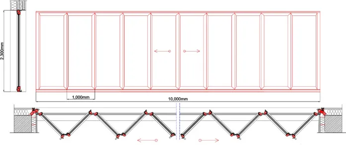
3.4 Architectural Drawings and Renders
Ground Floor Plan
First Floor Plan
Second Floor Plan
3rd _ 9th Floor Plan
Sections
Elevations
West elevation
West-south elevation
3D view
Technology
4.1 Climate analysis
•
Mexico climate analysis
As it is clear in the figure, all the Mexico country can be divided to seven main climate regions which Monterrey is mostly located in semi-arid areas of the country. The two main tropical areas are Mexico has two tropical climates which have average temperatures of over 18°C (64°F) for all twelve months of the year. The first, tropical wet has at least 60 mm of rain in
every month of the year. The second one is tropical wet-and-dry category has a pronounced dry
season.
The main factors of precipitation is raining in Mexico and as the figure shows in total most areas of the country has average value of precipitation with about 400up to 1000 mm of precipitation which Monterrey in located in this area too.
For reaching to scientific and complete view from the climate of Monterrey in Mexico, I try the climate consultant programme. As the nearest location for this analysis is the data from México City station so I forced to use from the potential data from this station and consider them for future design.
MONTERREY summary of weather condition
Human Thermal comfort can be defined primarily by dry bulb temperature and humidity, although different sources have slightly different definitions.
We choose ASHRAE handbook of fundamentals comfort model, 2005 with these consideration:
- Effective Temperatures of (20°C) to (23.3°C) (measured at 50% relative humidity), which means the temperatures decrease slightly as humidity rises.
- The upper humidity limit is (17.8°C) Wet Bulb and a lower Dew Point of (2.2°C) - If people are dressed in light weight summer clothes then this comfort zone shifts (2.8°C) warmer.
Weather data summary in Mexico station
Weather data summary in Mexico station
MONTERREY condition analysis
• Temperature Range:
Average annual climate of Monterrey
The mean value of temperature during the year is about 18 C⁰. As the graph shows the highest value is 28 C⁰ in May and the least temperature is 3 C⁰ in December. So as total this area is not very cold or very hot part of the earth. The average value between minimum and maximum temperature is tolerated from 12 up to 24 C⁰.
Average annual climate of Milan
When we compare Monterrey city with Milano it is clear that mean value of temperature in Milano is less than this value in Mexico City, so Milano is colder region than Mexico. Also the coldest time in Milano is in Jan with -9 C⁰ and hottest month is in August with 32 C⁰.
Ground temperature in Monterrey
As it clearly shows during April up to September near superficial layers of the earth the temperature is near 20 C⁰. In next six months as the precipitation is more, layers near the ground have lower temperature less than 15 C⁰.
•
Time table plot of dry bulb temperature:
It can be finding from the graph that maximum value of dry bulb temperature is related to months from March to January with 28 C⁰ in the morning. From 12 at noon up to 4p.m in evening in every month of the year dry bulb temperature shows 28 C⁰.
Average annual climate of Monterrey
•
Monthly Diurnal Averages:
Monthly Diurnal Averages
This graph shows the Mean value of dry bulb with upper red line and Mean values of wet bulb are shown with brown line. Distributed light blue lines in top show the hour by hour dry bulb temperature.
The Average Hourly Radiation for each month which is explained in Btu/sq.ft (Wh/sq.m) is shown with green for global horizontal radiation and for Direct normal and diffuse radiation type there can be seen in the shape of distributed light green and dark blue respectively.
•
Radiation Range:
Radiation chartin Monterrey
-The yellow column: direct normal solar radiation
-Green column: global (total) Horizontal Solar Radiation for all daylight hours in each month
- The solid black line: maximum hour for direct normal and Global horizontal in each month
Obviously it can be find that maximum value of direct normal is in February while this highest value for global horizontal is happening in May.
•
Sky cover:
3D chart ofSky cover range chartin Monterrey
Sky cover range chartin Monterrey
This graph show the percentage of sky cover for each month of the year, clear sky is 0% and 100% shows complete obscured sky. The Mean value can be seen in the form of break in bars of each month. Apparently in Dec and Jan of the year, almost 90% the sky is covered and the least value is for July with 60% sky coverage.
From the 3D chart we can get the same results that during winter specifically at noon, there is most sky coverage approximately over 60%.
•
WIND WHEEL:
From wind wheel we can get some specific results related to the quality and direction of the natural wind blowing.From Sep to the Feb in each year, mos powerful wind is blowing from east and souch east most hours of the day with 10 C⁰ with around 45% relative humidity with 24 m/s speed.
Wind wheel in autumn and winter
Wind wheel in spring and summer
The graph show that the speediest wind is blowing from the north, north east, east, south east and south with 22m/s speed, and medium relative humidity.