SEDIMENTOLOGICAL ANALYSIS OF DEEP WATER,
UPSLOPE-MIGRATING CROSS-BEDDED DEPOSITS IN A DISTALLY STEEPENED
CARBONATE RAMP (MENORCA, BALEARIC ISLANDS, SPAIN).
Rachele Andreetta
University of Ferrara Department of Earth Science
ABSTRACT
The upper Miocene units cropping out along the southern coast of the Island of Menorca (Balearic Islands, Spain), are mainly represented by two carbonate depositional systems: an early Tortonian distally steepened ramp (Lower Bar Unit) and an upper Tortonian – lower Messinian reef-rimmed platform prograding complex (Reef Complex). Within the distally steepened ramp, Pomar et al. (2002) distinguished four facies belts: fan-delta conglomerates passing upwards to bioturbated packstones (inner ramp), cross-bedded grainstones (middle- ramp), clinostratified rhodolithic rudstone (ramp slope) and fine-grained wackestone-packstone with planktonic foraminifera (outer ramp).
The backset-bedded units analysed in this work are placed at the transition between toe-of-slope and outer ramp sediments, below the wave-base-level. They infill the axial depression of large slide/slump scars. These scars truncate the gently, 10°- 12° basinward dipping, slope-to-outer ramp clinoforms.
Backset beds are cross-bedded forms that dip against the direction of flow of the depositing currents, therefore they present foresets migrating upcurrent (Gary et al., 1972).
These sedimentary structures are well known and largely described on the foreset and toeset of Gilbert-type fan delta (Postma, 1984; Massari, 1984, 1996; Nemec, 1990). In carbonate depositional systems these type of bedforms are rarely found and only little described.
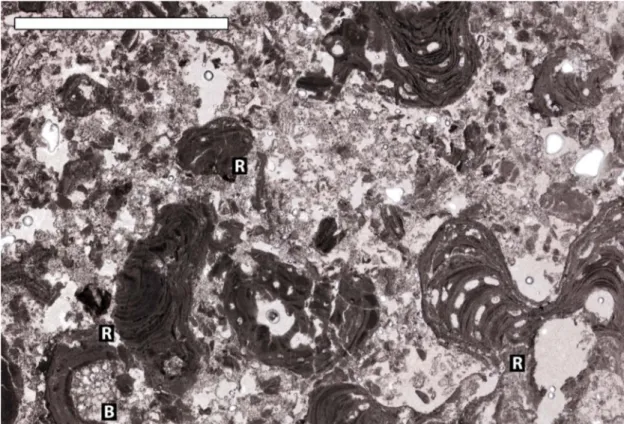
The backset-bedded units, here analysed, are channel-like, wedge-shaped, 10-12 m thick, pinching out landward and extend laterally for tens of meters. Each unit is formed by several amalgamated set of backset beds, 40 cm to 2 m thick. These units are mainly conglomerates composed by bioclastic coarse-grained grainstone to rudstone. Large components are rhodoliths, bivalves, skeletal and ooid-rich pebbles to boulders, gastropods and corals. Matrix is of a bioclastic coarse-grained sand to fine gravel, made of fragments of bivalves, gastropods, rhodoliths, bryozoans, algae, echinoids, loose ooids and planktonic and benthic foraminifera. Ooids are locally very abundant both in matrix and as main components of pebbles. Pebbles are mainly flattened, elongated, of average size 6-8 cm (a-axis) and sometimes have mollusc borings on their surface: large (20-30 cm) rounded and spherical boulders are locally present. Intergranular and intergranular porosity is very high, cementation low and dolomitization patchy.
Foreset laminae dip upslope with varying angles ranging from almost horizontal to 30°; higher angles are mostly found in the basinward part of the unit. Lamination is underline by the orientation along laminae of coarser components especially of bivalves, pebbles and rhodoliths. Grain-size distribution has a particular trend that
shows a progressive decrease in size landwards and upwards. Sorting may noticeably vary being high or absent in different bodies.
The lower boundary of the backset-bedded units is represented by scour surfaces which, on a parallel-to-flow section are almost concordant with the stratification below, while on a perpendicular-to-flow section are concave-up shaped, presenting the very steep walls.
The study of different outcrops along the coast evidenced some important variation in components: moving northward composition changed from almost completely rhodolithic-dominated to rhodolith-bivalve-ooid-pebble-dominated to bivalve-ooid-pebble-dominated with first findings of corals.
Upslope bedform migration has been explained as forming when a supercritical flow encounters a local obstruction or a local break on the slope, and a hydraulic jump may occur within the flow, upcurrent from the obstruction. Sediment will be therefore deposited at the obstruction forming an up-flow-dipping slipface that will tend to accrete and migrate in the upflow direction (Nemec, 1990 and reference therein).
The backset deposits of Menorca are found in deep-water settings but they are composed of shallow-water sediment. The formation of these backset beds is interpreted to be related to high energy storm-events able to remove sediment from shallow water and to transport it into deeper position. The sediment-rich outgoing flows channalized and accelerated along slide-scar axis, eroding and rapidly infilling up-slope the scours. In this portion of the ramp preservation potential is higher thanks to sediment deposition which buries and preserves these structures.
The repetitive occurrence of backset bedded units within the outer-ramp sediments and the progressive variation in composition suggest that those processes where probably active at the transition between the ramp and the reef systems. Therefore the formation of these sedimentary structures is interpreted to be strictly link to concurrence of peculiar morphological features, hydrodynamic energy and grain-size availability.
Computational fluid dynamic (CFD) numerical simulation have been performed as an integrated part of this work to improve the understanding of the development of hydraulic jumps within concentrated density flows. The simulated parameters do not refer to the example of Menorca but to turbidity currents for which finer-grain size (sand-size) have been used in a smaller-scale topography compared to the one studied in outcrop. The work presented proposes some new stating points for further simulations to constrain more precisely the main parameters controlling and determining the occurrence of a hydraulic jump and the consequent deposition of
RIASSUNTO
Le unità mioceniche affioranti lungo le coste della regione meridionale del Migjorn dell’Isola di Minorca (Isole Baleari, Spagna) sono caratterizzate da due sistemi deposizionali carbonatici: una rampa carbonatica di tipo distally steepened di età Tortoniano Inferiore (Lower Bar Unit) e una piattaforma carbonatica a margine biocostruito di età Tortoniano superiore-Messiniano inferiore che vi prograda sopra (Reef Complex). Nella rampa di tipo distally steepened, Pomar et al. (2002) ha distinto tre cinture di facies: dei conglomerati di fan-delta passanti verso l’alto a packstone bioturbati (rampa interna), grainstone a laminazione incrociata (rampa-media), rudstone clinostratificati a rodoliti (scarpata della rampa) e wackestone/grainstone a granulometria fine e foraminiferi planctonici (rampa esterna).
Le unità a laminazione a backset analizzati in questo lavoro si trovano alla transizione tra sedimenti di piede scarpata e quelli di rampa esterna, al di sotto della base d’onda. Queste strutture sedimentarie si trovano lungo gli assi di ampie superfici di collasso che troncano la successione di scarpata-rampa esterna, la quale immerge verso bacino con angoli di circa 10-12°.
I corpi a laminazione a backset presentano una laminazione incrociata che immerge nella direzione contraria a quella della corrente che li ha depositati, e quindi presentano una laminazione che migra contro corrente (Gary et al., 1972).
Queste strutture sedimentarie sono conosciute e ampiamente descritte lungo i foreset e i toeset di delta di tipo Gilbert (Postma, 1984; Massari, 1984, 1996; Nemec, 1990). Nei sistemi deposizionali carbonatici queste forme di fondo sono state raramente riconosciute e solo brevemente descritte.
Le unità a backset, qui descritte, sono canalizzate, a forma di cuneo, spesse circa 10-12 m, tendono ad assottigliarsi verso terra e si possono estendere lateralmente per decine di metri. Ogni unità è formata da una serie di set a laminazione a backset amalgamati, spessi da 40 cm a 2 m. Queste unità sono prevalentemente dei conglomerati composti da grainstone e rudstone bioclastici a granulometria grossolana. I componenti più grandi sono rodoliti, bivalvi, ciottoli a frammenti scheletrici e ricchi in ooidi, gasteropodi e saltuariamente coralli. La matrice è composta da un sabbia bioclastica grossolana a ghiaia fine, composta da frammenti di bivalvi, gasteropodi, rodoliti, briozoi, alghe calcaree, echinoidi, ooidi e foraminiferi bentonici e planctonici. Gli ooidi sono localmente abbondanti sia nella matrice che nei ciottoli. I ciottoli sono prevalentemente appiattiti ed allungati, mediamente di dimensione 6-8 cm (asse a) e talvolta presentano tracce di bioerosione da molluschi sulla superficie: grandi blocchi (20-30 cm) arrotondati e tondeggianti sono localmente presenti. La porosità inter- e
intra-granulare è molto alta, la cementazione tendenzialmente bassa e la dolomitizzazione casuale.
I foreset delle lamine immergono contro corrente con angoli che variano da quasi orizzontali a 30°; gli angoli maggiori si trovano prevalentemente nella parte più verso bacino dell’unità. La laminazione è evidenziata dall’orientazione lungo le lamine dei componenti più grandi in modo particolare dai bivalvi, ciottoli e rodoliti. La distribuzione granulometrica mostra degli andamenti particolari con una progressiva diminuzione della granulometria sia verso l’alto che verso terra. La cernita può variare molto da un corpo all’altro o essere da bassa ad assente.
Il limite inferiore delle unità a backset è rappresentato da superfici erosive che sono sub-parallele alla direzione di stratificazione dominante lungo la sezione parallela alla direzione del flusso, mentre nella sezione perpendicolare hanno una forma a concavità verso l’alto, con pareti anche molto ripide.
Lo studio di diversi affioramenti lungo la costa ha evidenziato alcune importanti variazioni dei componenti: spostandosi verso nord, la composizione varia dall’essere quasi totalmente dominata dalle rodoliti ad essere ricca di rodoliti, bivalvi, ooidi e ciottoli ad dominata da bivalvi, ooidi e ciottoli con primi ritrovamenti di coralli.
Quando un flusso supercritico incontra localmente un ostacolo e una rottura del pendio, nel flusso si genera un risalto idraulico, in posizione sopracorrente rispetto all’ostacolo: questo meccanismo spiega la migrazione verso l’alto rispetto alla scarpata di queste forme di fondo. Il sedimento si deposita quindi all’ostacolo, formando una superficie immergente contro corrente che tende ad accrescersi e a migrare in direzione contraria alla direzione del flusso (Nemec et al., 1990 e riferimenti).
I depositi a backset di Minorca si trovano in ambienti di acque profonde, ma sono composti da sedimento prodotto in acque poco profonde. La formazione di queste unità è stata interpretata come conseguenza di eventi di tempesta ad alta energia capaci di rimobilizzare sedimento dalla porzioni meno profonde della rampa e di trasportarlo in posizioni più profonde. I flussi ricchi di sedimento diretti verso bacino si incanalavano ed acceleravano lungo gli assi delle superfici di collasso, erodendo e rapidamente colmando le incisioni generate. In questa porzione della rampa il potenziale di preservazione è maggiore grazie alla successiva deposizione di sedimento che copre e fossilizza queste strutture.
Il ripetersi di queste unità nei sedimenti di rampa esterna e la progressiva variazione nella composizione suggerisce che questi processi erano probabilmente attivi alla transizione da sistema di tipo rampa a quello di tipo orlato (scogliera). Di conseguenza la formazione di queste strutture sedimentarie risulta essere strettamente legata alla concorrenza di fattori quali particolari caratteristiche morfologiche del fondo, energia
Simulazioni numeriche computazionali di fluido dinamica (CFD) sono state svolte come parte integrante di questo lavoro per migliorare la comprensione dello sviluppo di risalti idraulici in flussi a densità concentrata. I parametri simulati non si riferiscono all’esempio di Minorca ma a correnti di torbida a granulometria più fine (sabbie) ed anche la base topografica usata è più piccola rispetto a quella dell’affioramento. Queste simulazioni propongono alcuni nuovi punti di partenza per simulazioni future, ponendo costrizioni più precise ai principali fattori che controllano e determinano il verificarsi di un risalto idraulico e la conseguente deposizione di sedimento a laminazione a backset.
CONTENTS
1. Introduction………..1
1.1. The aim……….1
1.2. Methodologies………..2
1.3. Introduction to backset beds………..3
1.4. Studied area……….4
1.5. Definition of carbonate ramps………..5
2. Geological setting………10
2.1. The Migjorn ramp………14
2.2. The Reef Complex………..19
3. Sedimentary Facies……….22
3.1. Basic concepts and definitions……….22
3.2. The studied outcrops………26
3.3. Barranc des Pou……….30
3.3.1. Facies description……….33 3.4. Forma……….48 3.4.1. Facies description………51 3.5. Nalinot……….73 3.5.1. Facies description……….75 4. Facies Association………..103
4.1. Facies association A1: base-of-slope deposits……….103
4.2. Facies association A2: turbiditic wackestone/packstone to grainstone…104 4.3. Facies association A3: coarse calcarenite with planar parallel lamination………105
4.4. Facies association A4:backset bedded deposits……….106
5. Summary of data……….109
6. Supercritical flows and backset bedding……….121
7. Interpretation………135
7.1. Previous interpretation of the backsets of Menorca……….135
7.2. Depositional model………..135
8. Numerical simulations………..152
8.1. Introduction to computational fluid dynamics (CFD)………..152
8.2. Flow-3DTM………152
8.3. Research method……….156
8.4. Results of the present study………..158
8.5. Conclusion………..177
9. Conclusions……….179
10. Acknowledgment ………..182
1. Introduction
1.1 The aim
This thesis presents a sedimentological study and analysis of some large-scale cross-stratified deposits cropping out at the base-of-slope of a distally steepened carbonate ramp of Upper Miocene in the Island of Menorca (Balearic Islands, Spain). These deposits are characterized by coarse-grained breccia and conglomerate- beds with foreset migrating upslope, and have been interpreted for the first time by Pomar et al. (2002) as backset beds (“cross-stratification that dips against the direction of flow of the depositing currents” - Gary et
al., 1972).
The peculiarity of these kind of bedforms is that they have never been described within a carbonate depositional system, and so far the example cropping out in Menorca is the only one describe in a carbonate environment. These bedforms are still poorly understood and mainly known from siliciclastic environments therefore found in different depositional system dominated by different processes.
The main purpose of this study is to give a detail sedimentological analysis of the backset bedded deposits in terms of composition, geometrical architecture, grain-size of sediment involved and the relationships with the embedding deposits. Then, an interpretation is given for the processes that were responsible for the entrainment of the sediment in shallow-water settings (middle ramp, upper-slope), the processes that transported it seaward to the slope-break and the ones that transported it down to the base-of-slope where it has been deposited.
A particular attention will be given to the understanding of the parameters that drove and allowed their formation in this sedimentary environment.
The backset bedded deposits studied in the Island of Menorca are then compared to the ones known from different depositional settings. In siliciclastic environments in fact, scour-filling gravel and sand showing backset bedding are largely described on the foreset and toeset of Gilbert-type fan delta by many authors. These structures have been interpreted to develop at very high concentration of sediment during transport, and thus, the genesis of scour-filling backset beds on the foreset slope of a Gilbert-type systems may reflect the upstream migration of chutes and pools In carbonate environment these sedimentary structures have been reported only in few papers where they are shortly described (Lickorish and Butler, 1996; Massari and Chiocci, 2006) and they refer only to another example, the one at Monte Capodarso (Sicily, Italy).
The description of these deposits in this study will implement the still poor knowledge about the distribution of facies in carbonate ramp settings that so far still lack the numerous and extended references in literature if we compared to the studies about rimmed carbonate
Since the knowledge about the formation of backset beds is still poorly understood, the present thesis has been implemented with a section dedicated to a parallel work where computational fluid dynamic numerical simulations have been run using the dedicated software Flow-3DTM. Performing these simulations implemented the knowledge on the hydrodynamic
characteristics of the flows and the conditions that allow this bedforms to develop in submarine environments. The aims of performing these simulations was to give a quantitative analysis of the flow hydraulic conditions and their relationship to surface morphology, to better understand some of the major factors that control the deposition of sediment developing backset lamination along slope foreset and toeset.
1.2 Methodologies
The sedimentological description of the backset bedded deposits have been develop through a wide collection of data during an overall three months period of fieldwork spent in Menorca. The collection of information have been organized to obtain observation both at the smallest scale of the microfacies analysis in thin section, to the very large scale of the whole outcrop. In order to do this a large number of logs have been measured in several location along the sea-cliffs of the southern coast of the island. Each log has been sampled in detail for thin section analysis. Facies analysis and microfacies analysis has been done to improve the description of sediment composition and matrix and grain types, dominating skeletal grains and skeletal associations, to define the source of the sediment composing these beds. Samples of the embedding deposits have also been taken to improve the understanding of the position of these units and to better constrain the time of their deposition.
To facilitate the understanding of the vertical and lateral relationships with the embedding deposits and of the stratigraphical relationship between different sections in different locations, the measurement of logs has been coupled with drawing over photomosaics tied together with detailed measurements of each unit. This method has been widely used to reconstruct the geometries and architectures of these units in three dimensions. Facies distribution and geometries have been therefore mapped on photomosaics directly during field work when the outcrop was not too impervious.
Hydrodynamic studies have been carried out making use of dedicated software thanks to a collaboration with Prof. Wojtek Nemec, at the Department of Earth Science, University of Bergen (Norway).
Due to the large scale of these bedforms it would have been impossible indeed to reproduce them in a laboratory tank experiments, therefore computational fluid dynamics (CFD) numerical simulations, through the use of the dedicated commercial software Flow-3DTM , have
been used to attempt to reproduce a hydrodynamic flow conditions along a slope that may lead to the development of backset bed deposition at its base. This method allows to up-scale
there are still numerous constrains on the grain-sizes of sediment that can be adopted. Therefore the software does not allow to reproduce parameters corresponding to the ones observed in the studied outcrops in Menorca. The simulations have been done in collaboration with Complex Flow Design AS in Trondheim, Norway.
1.3 Introduction to backset beds
The formation of “backset bedding” (cross-stratification that dips against the direction of flow of the depositing currents - Gary et al., 1972, Reineck and Sing, 1980 and reference therein) has been attributed to 1) to the upstream migration of antidunes (e.g., Skipper, 1971, Alexander et al., 2001), 2) to flow under chute and pool conditions (Schmincke et al., 1973), and 3) to the upper-current migration of rhomboid ripple-marks (Wunderlich, 1972; 1973). In some of Hand’s (1974) experiments on density currents, chutes and pools developed at Froude number >1, sedimentation being related to up-stream migrating hydraulic jumps. Flows generating bedforms typical of supercritical flows, have been observed in flume experiments by Simons et al. (1965) and steeply-dipping backset beds have been experimentally produced for example by Jopling and Richardson (1966) in laboratory experiments.
In outcrop, scour-filling gravel and sand showing backset bedding are largely described on the foreset and toeset of Gilbert-type fan delta by Postma (1979, 1984a), Postma at al. (1983), Massari (1984, 1996), Postma and Roep (1985), Colella et al. (1987, 1988), Nemec (1990). These structures are interpreted to develop at very high concentration of sediment during transport, and thus, the genesis of scour-filling backset beds on the foreset slope of a Gilbert-type systems may reflect the upstream migration of chutes and pools.
Komar (1971) stated “hydraulic jumps (a hydraulic jump occurs when a supercritical flow, Fr>1, turns into a subcritical flow, Fr<1) are commonly expected to develop in the toeset, due to enlargement, dilution, strong reduction of the velocity and competence of the flow as it reaches the base of the slope”. The genetic link between backset beds and hydraulic jumps has been proposed by Massari (1984), Massari and Parea (1990) and Nemec (1990) who widely treated the behaviour of supercritical sediment gravity flows on steep slopes. When a supercritical flow encounters a local obstruction (or a local break on the slope: sites of abrupt flattening or even upflow inclination of the slope surface), a hydraulic jump may occur within the flow upcurrent from the obstruction. Sediment will be deposited at the obstruction forming an up-flow-dipping slipface that will tend to accrete and migrate in the upflow direction. According to Nemec (1990), hydraulic jumps can occur in granular material flows, and also in turbulent flows, in which case the effect will be roughly analogous to the formation of an antidune.
1.4
Studied area
Menorca is the northernmost island of the Balearic archipelago (Fig.1.4.1). This archipelago is the emergent part of the Balearic Promontory, the north-eastward extension of the Betic Range in western Mediterranean (Fig.1.4.1). This area underwent extension during the Mesozoic associated to the opening of the Tethys, and subsequent compression and thrusting during the Cenozoic. Paleo-relieves inherited from middle Miocene compressional tectonics resulted in paleo-islands during late Miocene and shallow water carbonate platforms developed around them especially on the southern coasts.
Fig.1.4.1 Geographical map (above) showing the position of the island of Menorca in the Western Mediterranean Sea and (right) respect to the other islands of the Balearic archipelago.
The Menorca Island can be subdivided in two main regions elongated in a NW-SE direction. The Tramuntana region to the north, is composed of Palaeozoic, Mesozoic and lower Tertiary rocks (Fig.1.4.2). To the south, the Migjorn region is composed by upper Miocene carbonates that unconformably overly the pre-late-Miocene basement, and have undergone only slight tilting and flexure associated with normal and strike-slip faulting during Late Neogene to Middle Pleistocene times (Obrador 1972-73).
The upper Miocene has been interpreted as being formed by two depositional sequences: the lower sequence was first defined as the Lower Bar Unit (Obrador et al., 1983, 1992) and later as the lower Tortonian distally steepened ramp by Pomar (2001a).
The study area is found in the south-eastern part of the Migjorn region, along the sea-cliffs close to Es Canutells where are excellent large outcrops. Three sites have been analyzed in detail: Barranc des Pou, Forma, Nalinot (Fig.2.1.2).
These outcrops allow studying the backset bedded deposits both along depositional dip and along strike. In Forma the section is E-W oriented while at Barranc des Pou and Na Linot the successions extend NE-SW and NW-SE. Those outcrops clearly document the relationship
between the coarse-grained bioclastic backset-bedded deposits and the units lying above and below.
1.5 Definition of carbonate ramps
The definition of ramp is “the sloping surface connecting two levels”. Previous studies done during the 1950s and 1960s, authors would have referred to such setting as a “typical shelf model”. The term “shelf model” was defined in 1888 by H. R. Mill as “…the shallow and
gradually sloping ground from sea margin out to the 100-fathom line, beyond which the descent to abyssal depths is abrupt”. This definition resulted to be quite inadequate in some
carbonate depositional systems.
Nowadays, the term ramp is widely used by siliciclastic sedimentologists for low-gradient submarine slopes, particularly on continental platforms. This term is used within carbonate depositional system with a different meaning. In order to avoid misunderstandings, a brief description of what is meant with the term carbonate ramp and the related classification is given below.
The ramp depositional model was defined by Ahr (1973), as a system in which the ramp is an inclined platform that extends basinward without a pronounced break in the slope. Therefore this model is characterized by the absence of a shelf-margin barrier. The allocation of facies was distributed parallel to coastline and it reflected the greater wave and current activity near the mainland shore. Therefore a carbonate ramp model is a sloping surface on which carbonate facies are deposited while subjected to open conditions from the surf zone to depth of hundreds of metres. Ahr (1973) underlines that the distribution of facies is different from the shelf model (the author calls “shelf model” the nowadays called “rimmed platform”, citing for example the Bahama Banks) . In the ramp model, grainstone and packstone are landward facies and the sediments become muddy as one moves seaward, while in the “shelf model” the landward facies are muddy, and they pass seaward into shelf-margin grainstones and boundstones. Anyway, this model is an old obsolete one that today has been widely enlarged.
The major features of this model are the concentric facies belts which follow bathymetric contours, the rather monotonous wedge-shape deposits thickening seaward except where local topography modifies the depositional trend and the absence of a continuous reef margin even if patch reefs may be present locally.
Wilson (1975) presents a classification of carbonate platforms (fig.1.5.1) and gave a definition of carbonate ramp based on the configuration of regional features “huge carbonate
bodies built away from positive areas and down gentle regional paleoslopes. No striking break in slope exists, and facies patterns are apt to be wide and irregular belts with the highest
Fig.1.5.1 Definition of (A) carbonate ramp, (B) carbonate platform and (C) definition of carbonate platforms, shelf margins and offshore banks (from Wilson, 1975).
Fig.1.5.2 (A) Block diagram of homoclinal carbonate ramp; (B) block diagram of distally steepened ramp (From Read, 1982).
Another classification of carbonate ramps came with Read (1982) where the carbonate ramp has been defined as a gently sloping (generally less than 1°) platform on which shallow wave-agitated facies of the near-shore zone pass downslope (without marked break in slope) into deeper-water, low energy deposits (Ahr, 1973). The difference from rimmed platforms is marked by the absence of a continuous reef margin and by the absence of sediment gravity flow deposits containing clasts of cemented, shallow water facies in deeper water facies. Near-shore skeletal complexes or ooid-pellet shoal complexes may characterize ramps.
Carbonate ramps have been classified in two different types homoclinal ramp and distally
steepened ramp (Read, 1982; see Fig.1.5.2). Homoclinal ramp are characterized by having a
gentle slope that dips into deep water, they may have skeletal or ooid/pellet sand shoal complexes, which pass without break in slope into deep-ramp nodular limestone, and then into pelagic/hemipelagic basin facies; deeper water facies usually lack significant slump and sediment gravity flow deposits. Homoclinal ramps are relatively rare in the Holocene and appear to be more common during the initial development of carbonate miogeoclines.
Distally steepened ramp is characterized by a marked increase in slope at the seaward edge
of the deep ramp, and they present frequent slumps, slope breccias and turbidites. Nevertheless, clasts of shallow platform margin facies are generally absent from breccias
A review of the occurrence of reef rimmed platforms and carbonate ramps through the Phanerozoic (Wright and Burchette, 1992) show that carbonate ramps are common in all geological periods, but where dominant at times when reef-constructing organisms were absent or inhibited. The authors also proposed a subdivision of the ramp environments based on wave-base (see fig. 1.5.3). Therefore they defined the inner ramp as the part of the ramp that goes from the shoreline to weather-wave-base, the mid-ramp extends from fair-weather wave-base (fwwb) to normal storm-wave-base, although the water depths which these boundaries represent vary and the outer ramp which occurs in distally steepened ramp, that goes from base-of-slope basinwards.
The four main environmental areas are characterized by a distribution of facies which is described and shown in fig 1.5.4 and 1.5.5.
Fig.1.5.3 The main environmental subdivision of a “homoclinal” carbonate ramp. MSL= mean sea level; FWWB= fair-weather wave-base; SWB= storm wave base; PC= pycnocline (not always identifiable in the rock record). Water depths corresponding to these boundaries are variable (From Burchette & Wright, 1992).
Fig.1.5.4 “Homoclinal” carbonate ramp showing main sedimentary facies. Inner ramp: (A) peritidal and sabkha facies with stromatolitic algae and evaporates; (B) bioturbated and variably bedded lagoonal lime mudstone, packstone and wackestone; (C) shoreface or shoal cross-laminated oolitic or bioclastic grainstone and packstone. Mid ramp: (D) amalgamated coarse, graded tempestites, commonly with hummocky cross-stratification. Outer ramp: (E) fine grained, graded tempestites interbedded with bioturbated or laminated lime or terrigenous mudstone; (F) laminated or
Fig.1.5.5 Highly schematic vertical section through several end-member ramp depositional systems, showing variation of facies within inner-, mid-, and outer- ramp depositional environments and how these are related to fair-weather wave-base (FWWB) and storm wave-base (SWB). (A) Proterozoic stromatolite-dominated ramp, showing variations in stromatolite morphology with depth. Based on Grotzinger (1989). (B) Skeletal boundstone-dominated ramp, typical of early Palaeozoic and later Mesozoic succession. Based on Burchette (1981) and Burchette & Britton (1985). (C) Grainstone dominated ramp, typical of early Carboniferous and Jurassic, and some modern ramps. Based on Ahr (1973), Baria et al. (1982) and Burchette et al. (1989). (D) Large-foraminiferan shoal-dominated ramp, characteristic of those in the Paleogene and early Neogene. Based on Aigner (1983). Profiles are valid for several scales of sequence (Burchette & Wright, 1992).
In the models proposed by these authors, carbonate ramp system the carbonate productivity of carbonate ramp system in the inner ramp shows lower production rates than comparable shallow-water facies on rimmed shelves. Anyway this is again an old concept since several authors believe that the rate of dissolution is very high and production may be comparable to rimmed shelf (e.g. Chems et al., 2008; James et al., 2005).
As for the type of sedimentary basin, the authors observed that these systems best develop where subsidence is flexural and gradients are slight over large areas, as in foreland and cratonic-interior basins along passive margins. Moreover it is noticed that ramps compared to rimmed shelves, respond differently during relative sea-level changes because of their low-angle slopes, even though it seem to be strongly dependent on the rate of sea-level change.
Fig.1.5.6 Ternary diagram showing suggested classification for carbonate ramps based on the degree of storm, wave or tidal influence which they exhibit in the mid- and inner-ramp zones. An additional axis accommodates the various lithologies which dominate ramp sediments and seem to reflect the level of environmental energy (see arrow). Several representative ramps have been entered. See text in Burchette & Wright (1992) for source references on the characteristics of individual ramps (Burchette & Wright, 1992).
In the work here presented the “distally steepened carbonate ramp” is intended sensu Read (1982), a ramp which is similar to an homoclinal ramp, but with a distinct increase in gradient in the outer, deep ramp region. The width of this kind of ramps is between 10 and 100 km. A modern analogue can be the platform of the Northeastern Yucatan, western Florida.
2. GEOLOGICAL SETTING
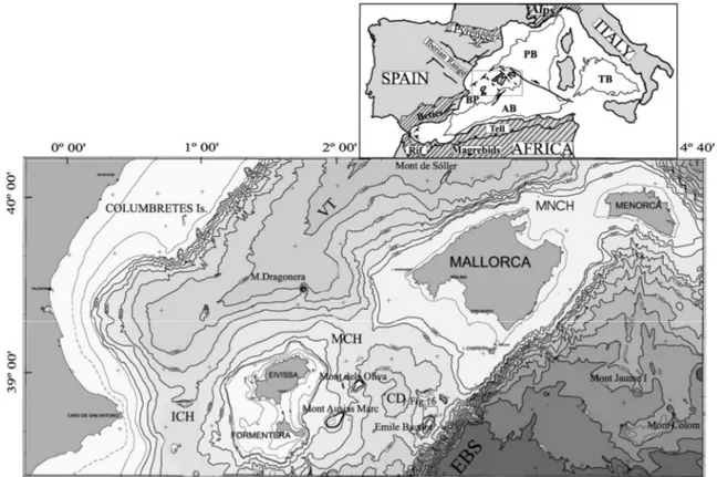
Menorca is the northernmost island of the Balearic archipelago. This archipelago is the emergent part of the “Balearic Promontory”, the north-eastward extension of the Betic Range in western Mediterranean (Fig.2.1).
Fig.2.1 Location map of Menorca showing its position on the Balearic Promontory and the surrounding basins.
The opening of the Atlantic ocean caused the collision of the African plate with the Euroasiatic plate, with subduction of ocean crust below the european margin. This convergence, that has been estimated to be of 400-500 km in the western part and of 1500 km in the eastern part (Krijsman, 2002), occurred from the mid-Cretaceous to the Palaeogene times and gave rise to the Alpine orogeny and to the progressive closing of the Tethys ocean that during the Mesozoic was separating the African plate from the Euroasiatic plate.
The opening of the Western Mediterranean occurred during two main quick phases of subduction migration to the east consuming the westernmost part of the Tethys, creating smaller basins. During the first phase the Balearic–Algerian Basin was formed due to the radial extension originated by the rotation of the subducted plate which caused the drift of the Sardinia-Corsica block with an anti-clockwise rotation. From the Tortonian to the Quaternary, the second phase was dominated by an extensional deformation, more pronounced to the east where the Tirrenian Basin opened.
The architectural structure of the Western Mediterranean is therefore dominated by extensive faults trending NE but with significant differences at the margins. The north-western margin, corresponds to a passive margin where series of horst and graben are aligned along a
NE direction; those formed during the Oligocene and lower Miocene and were buried by more recent sediments that fossilized this extensive structure. On the other hand, the south-east margin was more complex; the Sardinia-Corsica block and the Balearic Promontory are separated by a directional fracture with right-movement and NW direction.
Fig. 2.2 Location and bathymetry of the Balearic Promontory. Bathymetric contour interval is 200 m. ICH, Eivissa Channel. MCH, Mallorca Channel. MNCH, Menorca Channel. VT: Valencia Trough. CD: Central Depression. EBS: Emile Baudot Scarpment. Insert: Geographic and structural scheme or bathymetry shows only 2000 m isobath. BP: Balearic Promontory. AB: Algerian Basin. PB: Provenc_ al Basin. TB: Tyrrhenian Basin (modified from Acosta et al., 2003).
While the eastward movement of the Sardinia-Corsica block was creating the Liguro-Provençal Basin, the Balearic margin was formed by the NE extension of the Betic Range, developed following the rifting phase that opened the Valencia Trough, a northeast trending aborted rift. This V-shaped Trough has a maximum width of 400 km and to the northwest it limits the Balearic Promontory (Menorca is found in the northernmost part), while to the southeast it is limited by a NE-SW steep scarp, the Emile Baudot Scarp, which has been interpreted as a possible transform fault of tectonic origin (Acosta et al., 2001).
The Balearic Promontory is therefore a structural high, 1000 to 2000 m high with respect to the surrounding basins. It is bounded to the north by the Balearic-Provençal Basin and to the south by the Balearic-Algerian Basin. To the southeast it is limited by the Emile Baudot Scarp (Fig.2.2). The present configuration of the Balearic Promontory is due to the westward migration of the Alboran microplate which caused the clockwise rotation of the Mallorca and Ibiza blocks (Andrieux et al., 1971; Auzende et al., 1973a,b; Balanyá and García-Dueñas,
The Promontory is morphologically subdivided into two tectonic blocks: the Menorca and Mallorca block and the Ibiza and Formentera block. Menorca and Mallorca share the same narrow continental platform which is steeper to the north and wider and more gentle inclined to the south.
With regard to Menorca, the platform to the north-east is structurally controlled and it is very narrow ( about 10 km) and steep (6°). On the margin there are numerous gorges and valleys incised during the Messinian crisis (Hsü et al., 1973) due to the lowering of base-level. To the south-west the platform is wider with a constant depth and continuous without interruption to Mallorca (maximum depth -60 m). To be noted, offshore of Son Bou, the presence of an incised submarine canyon oriented N-S, whose head is at about 5 km from the shoreline and at about -80 m, which extends down to the toe-of-slope at -1400 m. Associated to this canyon there is a turbiditic fan that expands down to the abyssal plain at -2400 m. This canyon works collecting biogenic sediment produced by the platform and transporting it downslope (Maldonado & Stanley, 1979).
The geology of the Balearic Islands is characterized by Mesozoic, Palaeogene, and Middle Miocene folded and thrust rocks which are flanked by areas covered with slightly deformed Late Miocene to Pleistocene sedimentary rocks (Fig.2.3).
Fig.2.3 Simplified geological map of the Island of Menorca: the northern part of the island is mainly composed of Palaeozoic and Mesozoic rocks, while Tertiary rocks are found in the southern region (Rosell et al.).
This area underwent extension and thinning during the Mesozoic associated to the opening of the Tethys related to the break up of Pangea. During the Palaeogene, this continental-crust segment suffered a lithospheric flexure produced by the onset of the Alpine orogeny. The major compressional events occurred during mid Miocene, as well as in south-eastern Spain (Betic Range) and northern Africa (Maghrebides Ranges). These ranges have a northeast trends and the dominant structural style is that of stacked thrusts sheets which during the Middle Miocene, were placed toward the northwest. Paleo-relieves inherited from middle Miocene compressional tectonics resulted in paleo-islands during late Miocene and shallow water carbonate platforms developed around them especially on the southern coasts. The Upper Miocene deposits suffered only slight tilting and flexure related to normal and strike-slip faulting during the late Neogene to middle Pleistocene time.
Fig.2.4 Simplified geological map of the Island of Menorca (modified from Pomar et al, 2002).
The Menorca Island can be subdivided in two main regions elongated in a NW-SE direction (Fig.2.4). The Tramuntana region to the north, is composed by the Silurian shales, Devonian limestones and Carboniferous siliciclastic turbidites (Palaeozoic), by the Triassic red sandstones, dolostones and red marls, Jurassic dolostones and some Cretaceous limestone (Mesozoic) and Oligocene limestone conglomerates (lower Tertiary rocks) . To the south, the Migjorn region is composed by upper Miocene carbonates that unconformably overly the pre-late-Miocene basement (Obrador 1972-73), and have undergone only slight tilting and flexure associated with normal and strike-slip faulting during Late Neogene to Middle Pleistocene times.
2.1 The Migjorn ramp
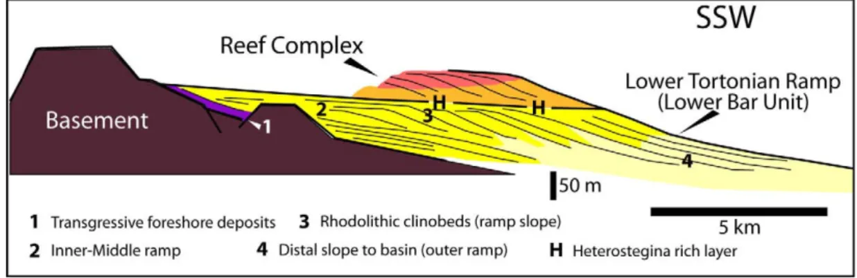
The Migjorn ramp is, volumetrically, the most significant deposit in the Island and it represents deposition on a progradational distally steepened carbonate ramp (sensu Read, 1985). The Migjorn ramp reaches a thickness of up to 500 m in the subsurface. The carbonate ramp is dated early Tortonian in age (N16 zone of Blow) according to Bizon et al. (1973). Lithofacies, bedding patterns and internal architecture have been described in Pomar (2001), Pomar et al. (2002), Brandano et al. (2005) and more recently, a depositional model and paleoecological interpretation (Fig.2.6) based mainly on large benthic foraminifera as carbonate-producing biota, in Mateu-Vicens et al. (2008).
Fig.2.5 Lithofacies of the Lower Tortonian Lower Bar Unit and the overlying Reef Complex on the eastern side of Menorca (modified from Pomar et al., 2002).
This carbonate platform corresponds to a highstand system tract prograding and aggrading over a Palaeozoic, Mesozoic and locally lower Tertiary basement.
Inner ramp
The inner-ramp extends seawards from the palaeoshoreline to about -15m depth as estimated by Vicens-Mateu et al. (2008), which corresponds to the fair-weather wave-base (Fig.2.5). Deposits next to shoreline are composed of siliciclastic sandstones and conglomerates; Pomar et al. (2002) distinguished two main lithofacies: conglomerates and
Conglomerates and red sandstones to siltstones: this facies is composed of clasts derived
from Palaeozoic siliciclastic rocks and Mesozoic carbonate and siliciclastics. Crudely to well stratified pebble and cobble conglomerate are interbedded with conglomeratic red sandstones and red siltstones sometimes with landward-dipping imbrication. Matrix is of reddish sand or sandy silt and red siltstone present root structures sometimes with scattered pebbles. Carbonate clasts are not bioeroded and marine fossils are absent. This lithofacies has been interpreted to represent continental deposition in an alluvial-dominated environment.
Cross-bedded pebbly sandstone: this facies has well stratified beds of matrix-supported,
pebbly sandstones. Beds gently dip (up to 10°) in a seaward direction and the presence of echinoids and marine gastropods point to a marine depositional environment. Components are quartz sand with some pebbles and cobbles, with pebbles showing seaward imbrication. Some clasts are subangular and mica is sometimes present, suggesting a short transport distance.
This lithofacies has been interpreted to represent foreshore deposits of a low-wave energy environment.
Structureless conglomerates and pebbly sandstones: beds are stratified from horizontal to
gently dipping basinwards. With a lower conglomeratic interval that passes upwards into a structureless pebbly sandstone. Bounding surfaces are diffuse and undulate to sharp and erosive. Conglomerate are mainly clast-supported. Most clasts composing this facies are derived from Palaeozoic sandstones and shales or from Mesozoic carbonate rocks. Pebbles may be bored by sponges and when disc-shaped they are imbricate both landward and seaward. Sandstones are composed of poorly sorted quartz sand with few granules and pebbles, commonly structureless and bioturbated. Moulds of bivalve and whole skeletons and fragments of echinoids also characterize this unit. This lithofacies has been interpreted to represent small point-sourced fan-delta deposits reworked in a shoreface environment.
The siliciclastic sandstones and conglomerates pass basinwards into bioturbated carbonate
packstones. Sediments of this facies are structureless, wave-related structure are absent and
pervaded by bioturbation. Beds may be subhorizontal to gently seaward-dipping, crude to well stratified. Components are mollusc fragments and foraminifera with scattered whole-shell bivalves, the basal beds are rich in echinoid fragments, bivalve and gastropod moulds. Sediment is mainly structureless with slightly visible large-scale cross lamination dipping both landward and seaward. Ichnofossils are locally frequently found (Ophiomorpha).
This facies has been interpreted as a shallow-water, euphotic environment subjected to wave agitation but where transport and sorting of sediment was prevented by trapping, baffling and sheltering in seagrass beds (Pomar et al., 2002; Mateu-Vicens et al., 2008).
Fig.2.7 Carbonate production and sediment accumulation in the lower Tortonian carbonate platform of Menorca (from Mateu-Vicens et al., 2008).
Middle-ramp
Seaward, the middle-ramp is composed of medium- to coarse-grained cross-bedded largely dolomitized dolopackstone-grainstone with matrix of dolomite cement, with red algae (Mastophoroids and Melobesioids), molluscs and echinoids, bryozoans, low oxygen foraminifers, large benthic foraminifera (Heterostegina and Amphistegina), scarce planktonic foraminifera, ex situ epiphytic foraminifers (rotaliids and textularids). Subangular, quartz sand-sized grains and lithoclasts are also present. This facies is characterized by planar to trough cross-bedding dipping angles of 4°-5° and internal lamination mainly dipping W-NW of about 10°-20°. Cross-stratification may be locally destroy by bioturbation. These bedforms have been interpreted as subaqueous 2D-dunes with compound cross-bedding produced by the migration of superposed small bedforms (sensu Ashley, 1990, in Pomar et al., 2002).
Based on foraminifera and red algae associations and on wave related structures, depth range of -15 to -50 m has been suggested for the middle ramp (Fig.2.5 and 2.6-7)
(Mateu-Vincens et al., 2008), which means the part of the ramp between fair-weather wave-base and storm-wave-base. Large benthic foraminifera such as Amphistegina and Heterostegina, in fact, occur preferentially in the middle and deeper part of the photic zone in tropical to subtropical environments (Hottinger, 1997). Red algae are often found in pockets of rhodoliths embedded in cross-bedded grainstones, in the lower part of the middle-ramp.
The presence of cross-bedded grainstones represent subaqueous dunes produced by episodic, unidirectional sub-wave-base currents; the middle ramp is thought to be dominated by unidirectional currents, paralleling the bathymetric contour lines that were able to rework bioclastic sediment produced below fair-weather wave-base.
Ramp slope: Upper ramp slope and Lower ramp slope
Ramp slope facies are present as large-scale clinobeds dipping 15°-20° basinwards, those have a minimum visible length that ranges from 100 to 200 m and prograde mainly on a SW direction, for 2,5 km. Clinobeds are composed of rhodolithic rudstones to floatstones, that alternate with grainstone intervals containing rhodolithic rich-layers. The Upper ramp slope is mainly composed of red-algae rudstone to grainstone clinobeds: in situ rhodoliths and red algal debris interbedded with coarse- to medium-grained grainstones, rich in red algal fragments, echinoids, bryozoans and foraminifera (low oxygen foraminifers, Heterostegina,
Amphostegina but not very abundant), planktonic foraminifers, molluscs and echinoids, filter
feeders). Red algae genera found in the ramp slope include Melobesioids (Lithothamnion,
Mesophyllum), mastophoroids (Spongites and Lithoporella), lithophylloids (Titanoderma and Lithophyllum) and Sporolithon (Pomar et al., 2002; Brandano et al., 2005) and their fragments
range from rounded to angular. Quartz grains and lithoclasts can be abundant. The occurrence of complete rhodoliths together with red-algal fragments indicate a deposition close to the production locus. The more rounded fragments may represent the sediment fraction transported seaward from the middle ramp by currents. Dolomite replacement is pervasive.
The progradational character of the clinobeds and the steepened slope indicate a zone of increased sedimentation rate due to sediments produced in situ and to sediment swept by waves and currents from inner and middle ramp (Pomar, 2001a). The association of LBF and red algae found along the slope correspond to diminishing light intensity as a consequence of increasing depth or nutrient flux and water depth has been estimated being -50m in the upper slope and -80m at the toe-of-slope (Mateu-Vicens et al., 2008).
These progradational clinoforms represent a progressive seaward shifting of the locus of main deposition, forming a depositional slope below wave-base. Rhodoliths and coralline algae (branching and foliose), growing in the deepest part of the photic zone (oligophotic), were episodically moved by storm-induced currents but mostly represent `in situ' accumulation.
represent turbiditic and debris flow deposits. These intervals are composed by LBF (including
Borelis), epiphytic foraminifers and red algae. Massive or with convex-up to horizontal
lamination floatstones are composed of fragments of echinoids, molluscs, large bivalves, bryozoans and very rare fragments of coral (Porites) and they can be found in a sandy matrix. Pectinids, serpulids and entire brachiopods are found in more massive grainstone/packstone intervals.The very low P/B ratios has been interpreted by Mateu-Vicens et al. (2008) as reflecting active downslope sediment-transport processes along slope.
Small-scale bedforms of cross-bedded grainstones migrating westward, parallel to the slope, represent reworking of carbonate sands by bottom current flowing parallel to depositional strike, on a slope dipping up to 10° (Pomar et al., 2002). They are composed of recrystallized skeletal grains with accessory quartz. The absence of photo dependent organisms place the lower slope in the lower end of the photic zone. The deposits found in this environment represent sediment that has been transported downslope by gravity flows and successively reworked by bottom currents.
Toe-of-slope and Outer ramp
Passing towards the outer ramp the slope interfingers basinward with thinly bedded, gently undulated fine-grained dolopackstone/wackestone graded beds that have been interpreted as turbiditic deposits. Common skeletal components of the outer ramp lithofacies are planktonic and small benthonic foraminifera with subordinated echinoid tests and spines, pectinids and bryozoans colonies are frequent in some beds. Channel-fill deposits and graded packstones/grainstones are present in more proximal settings and they contain fragments of red algae, echinoids, molluscs and bryozoans, planktonic and benthic foraminifera (mainly rotaliids and textulariids). The laminated fine-grained wackestone/packstone in proximal settings may interfinger with graded packstone/wackestone that are interpreted as distal turbiditic deposits, and channel-fill deposits that have been interpreted as tongue of debris-flow at the toe-of-slope. Those are composed of fragments of red algae, echinoids, molluscs and bryozoans, planktonic and benthic foraminifera.
The absence of in situ light-dependent skeletal components places the outer ramp below the photic zone (Pomar, 2001a; Mateu-Vicens et al., 2008). These sediments dip gently SW (basinward) (<10°). On a larger scale, bedding is slightly undulated in a strike direction with some 100 m in wavelength and up to 1-2 m in height. Wavy features are partly attributed to depositional processes, but others are associated with shear bands and to synsedimentary gliding deformation (Pomar et al., 2002).
The gently basinward-dipping beds are truncated by large scale troughs, up to 1km wide and 60 m deep with axis oriented along depositional dip. These troughs are in-filled with the same fine-grained wackestone/packstones. The coarse-grained backset-beds are commonly found along the axis of these troughs.
At the base-of-slope in a distal position, large-scale coarse-grained cross-bedded grainstone units interbed with the fine-grained wackestone/packstone. These units are composed of well-sorted, coarse-grained, red algae debris and benthic foraminifera (mainly miliolids and textulariids). Laminae dip 10-20° NW. These grainstone have been interpreted by Pomar et al., (2002), to correspond to large 3D subaqueous dunes (sensu Ashley, 1990). They represent extensive along-slope transport and accumulation of carbonate sands by bottom currents flowing towards the NW, paralleling the depositional strike.
Fig. 2.8 Synthetic cross-section of Menorca, showing the stratigraphic relationships of Upper Miocene depositional units. Based on outcrop data, mainly from the eastern and western sides of the island, and water-well data (modified from Obrador et al., 1992). (Slightly modified from Pomar et al., 2002). The architectural geometry of the carbonate platform noticeably changed from the lower Tortonian ramp to the Reef complex. The change from a distally steepened ramp into a rimmed platform completely change the profile, the morphology of the topography of the depositional system.
2.2 The Reef Complex
The Upper Tortonian-Lower Messinian unit is represented by the Reef Complex, a progradational reef-rimmed platform that reaches a maximum thickness of about 180 m and it is found in all the Balearic Islands. On Mallorca, it conformably overlies at the depocenter the Heterostegina calcisiltites and unconformably on the margins on the folded basement. The upper boundary is an erosion surface with Karstic caves and paleocliffs.
These reef complexes developed in shallow submerged areas around islands, extensively prograding on the southern margins of the three largest islands (Menorca, Mallorca and Ibiza-Formentera), suggesting that this was their leeward side (Pomar, 2005).
The most extensive accumulation of this rimmed platform is the Llucmajor Platform, a 20 km-wide platform cropping out in Mallorca. The Reef Complex is composed of similar lithofacies defined by their lithology, constituents, stratification and relationships on both Menorca and Mallorca islands (Pomar, 1991; Pomar and Ward, 1994, 1995, 1999; Pomar et al., 1996).
The Reef Complex on the Island of Menorca, is just partly exposed where it has been mostly removed by erosion but it is very well and largely exposed on Mallorca (Pomar and Ward,
1992; Jurado 1985) unconformably overlies the pre-late Miocene rocks (Fig.2.8). The lower boundary is erosive at the margin of the basin while it’s conformable over the Migjorn ramp. The upper boundary is an erosive surface. The Unit presents lithofacies very similar to those described at the near Island of Mallorca. The rocks of this depositional sequence are commonly partly-to completely dolomitized and four major lithofacies have been distinguished (Pomar et al., 1996).
Lagoonal lithofacies have been subdivided in outer-, middle- and inner-lagoon lithofacies:
outer lagoon rocks are characterized by coral patch reefs (Porites, Tarbellastraea and minor
amounts of Siderastraea) and horizontal layers of skeletal grainstone and packstone with lenses of coral breccia. Outer-lagoon grainstone and packstone are composed of abundant red algal fragments and rhodoliths, echinoids, benthic foraminifera and molluscs; common to rare constituents are also serpulids worm tubes, Halimeda, bryozoans, miliolids and peloids. Middle
lagoon lithofacies is composed mainly of unstratified packstone/grainstone with red algae,
echinoids, benthic foraminifera and molluscs, bryozoan, Halimeda and coral fragments, peloids and ceritid gastropods can be present. Inner lagoon rocks are composed of thin- to medium-bedded grainstone, packstone, and mudstone layers with abundant foraminifera and molluscs. Foraminifera like alveolinidis, soritids and trochamminids can be found. Some beds are dominated by pellets and peloids, while others by ceritid gastropods. Ooids, ostracods, red algae, oncolites, and oogonia of charophyta are also present. In this lithofacies stromatolites, thrombolites, sub aerial crusts and paleosoils are also found with frequent rhizocretions preserved in mangrove-swamp lime mudstone.
Reef-core lithofacies: this lithofacies interfingers landward with lagoonal lithofacies and
basinward with fore reef-slope lithofacies, and it is composed by massive coral-reef limestone and dolostone. The reef framework is constructed only by three genera: Porites, Tarbellastraea and minor amounts of Siderastraea. Secondary components of the reef-structure are encrustation of red algae, foraminifera, bryozoans, worm tubes, vermetid gastropods and microcrystalline rinds and crusts (cyanobacteria?). In the lower part of the reef, coral build-ups are inter layered with medium to coarse skeletal dolograinstone.
Reef slope lithofacies have been distinguished in distal and proximal; they consist of a
succession of clinoform-beds tens to hundreds of meters long, composed of dolomitized coarse-skeletal grainstone and packstone. Distal-reef-slope deposits are gently dipping (<10°), poorly stratified, intensely burrowed, red algae-mollusc dolopackstone to dolograinstone. These beds are characterized by rhodoliths, large whole-shell bivalves, sclerosponges and large oysters with local bioherms of branching and encrusting red algae. Proximal-reef-slope has steeper dipping angles (10° to 30°) and interfinger landward with in situ coral reefs. It is composed of dolomitized skeletal and intraclastic grainstone, packstone, rudstone and floatstone with red algae fragments and rhodoliths, coral fragments, bivalves, gastropods, echinoids, bryozoans and Halimeda.
Open-shelf lithofacies: this facies is characterized by flat lying, poorly bedded because of
bioturbation and mostly dolomitized fine-grained skeletal packstone/wackestone. Twp different types are distinguished: a red algal lithofacies, coarse-grained, poorly sorted, red algae-rich grainstone/packstone to rudstone/floatstone with rhodoliths and other skeletal components such as oysters, pectinids, large foraminifer Heterostegina and corals like Tarbellastreae and
Porites; a packstone-wackestone with planktonic foraminifers lithofacies that usually overlies
the red-algae-rich open-shelf deposits both in cores and outcrops along the western coast of the Llucmajor Platform. This lithofacies can be followed into distal slope strata of the reef complex and it is characterized by fine-grained packstone and wackestone rich in planktonic foraminifera, ostracodes and very fine detritus of oysters, bivalves, echinoids and red algae.
The Reef Complex has been dated to late Tortonian-early Messinian based on regional considerations (Pomar et al. 1983, 1996; Pomar, 2001a), planktonic foraminiferal assemblages (N17 foraminiferal biozone of Blow, Bizon et al., 1973; Alvaro et al., 1984). Sr isotopes estimates provide a late Tortonian age (Oswald, 1992) while K-Ar dates are 7.0 ± 0.2 Ma for biotite and 6.0 ± 0.2 Ma for sanidine phenocrystals (volcanic ash) indicating early Messinian age near Cap Blanc, Mallorca (Pomar et al., 1996). More recent Ar-Ar dating has provided an age of 6.4 Ma for the same volcanic minerals (Pomar, personal com.; unpublished data).
3. SEDIMENTARY FACIES
3.1 Basic concepts and definitions
In a sedimentological analysis one of the first step is to recognize sedimentary facies and to interpret them to understand their origin (Reading and Levell, 1996). Sedimentary facies are the basic types of sedimentary deposits, distinguished macroscopically on a descriptive basis as the elementary “building blocks” of a sedimentary succession (Nemec, lecture compendium). The aim of define sedimentary facies is to recognize the principal processes of sediment transport and deposition which may be directly diagnostic of a particular sedimentary environment while others can be found in different environments as for example current-ripples): in the latter case, facies association become fundamental because are more informative (see chapter 4).
The term “facies” appears for the first time into geology thanks to Nicholaus Steno (1669) with the meaning of the entire aspect of a part of the earth’s surface in an interval of time.
The modern usage of the term “facies” was introduced by Gressly (1838) who used it to refer to the sum total of the lithological and palaeontological aspects of a stratigraphic unit.
This term has long been the subject of debate, in fact it has been used with a wide variation of meanings. The discussion have been centred on: 1) does the term implies an intangible set of characteristics, as opposed to the rock body itself?; 2) does the term have to be use only to refer to “areally restricted parts of a designated stratigraphic unit” (Moore, 1949), or as used by Gressly also to stratigraphically unconfined rock bodies?; 3) does the term to be merely descriptive or also interpretative? (Walker, 1992).
Walker (1992) suggest that the most useful modern working definition of the term “facies” was given by Middleton (1978): “the more common (modern) usage is exemplified by de Raaf
et al., (1965) who subdivided a group of three formations into a cyclical repetition of a number of facies distinguished by lithological, structural and organic aspects detectable in the field. The facies may be given informal designations (“Facies A” etc.) or brief descriptive designations (e.g. “ laminated siltstone facies”) and it is understood that hey are units that will ultimately be given an environmental interpretation; but the facies definition is itself quite objective and based on the total field aspect of the rocks themselves… The key to the interpretation of facies is to combine observations made on their spatial relations and internal characteristics (lithology and sedimentary structures) with comparative information from other well-studied stratigraphic units, and particularly from studies of modern sedimentary environments”.
The subdivision in facies is therefore a classification procedure, whose degree of subdivision is determined mainly by the aims of the study whereas the scale at which the subdivision has to be done depends on the detail that we want to achieve but mostly by the quality of the
Different ideas on sedimentary facies come from different groups since each group’s concept is based on traditions, particular regional geology and nature of the data (outcrop, wireline log core etc.). In Reading and Levell (1996, p.18-19) three main schools are summarized: the group of the British/Dutch/Shell School, represented in the 1960s by Allen, Bouma, Collinson, de Raaf, Kruit, Kuenen, Middleton, Oomkens, Reading, van Straaten and Walker in Britain, Holland and Canada, by Bernard, Ginsburg, Hsü, Le Blanc, Visher, Wilson of Shell Oil in the USA, by Fischer, Klein and Van Houten from the eastern USA, Mutti and Ricci Lucchi in Italy and many others; the group of the Gulf Coast School, from Texas and Louisiana of south-central USA, represented by Brown, Fisher, Fisk, Frazier, Galloway and McGowen; the group of the Cratonic/North Western/Exxon School firstly develop by Sloss (1950, 1963) and later reviewed by the Exxon School of seismic interpreters and geologists such as Haq, Mitchum, Posamentier, Sangree, Sarg, Vail and Van Wagoner. The three schools basically came from the fact that they were working on different geological regions where different methodologies at different scales, were possible to be utilized or not, to investigate the subsurface. The first school based its attention on small-scale features of rocks, sedimentary structures and processes, and developed models based around Walter’s Law; the approach comes from inland outcrops where tectonic activity made difficult to trace facies distribution both vertically and laterally, but thanks to good streams and/or coastal sections measuring of logs was possible and emphasis was laid on sedimentological, intrinsic and autocyclic causes, and external, allocyclic controls were used only when explanation of facies relationships was exhausted with intrinsic controls. The second school, is based on large areas with insignificant tectonic deformation, with poor outcrops but with data coming from cores, few good quality seismic lines and abundant electric logs; this kind of collection of data leads to regional isopah, sand thickness and sand percentage mapping which takes to interpretation of regional-scale, three-dimensional facies relationships. Therefore a detail facies analysis as in the
British/Dutch/Shell School is neither possible nor necessary to interpret sedimentary
environments, but it allows a wide, lateral correlation with large-scale facies patterns where thick “facies sequences” could be easily laterally linked together as “genetic stratigraphic units” (Frazier, 1974; Galloway, 1989). This model, that focuses on breaks in sedimentation of very slow or no sedimentation, over large-scale system, is suitable where high influx of clastic sediment supply dominate the control on facies patterns in large regions with substantial but even subsidence. The third school focus its attention on unconformities that could be traced for hundreds (or thousands) of kilometres with little apparent facies change (Sloss, 1963). Again emphasis is put on major hiatal bounding surfaces that can be traced for hundreds of kilometres to separate thin but laterally extensive packages of sedimentary facies. This can be applied to regions characterized by tectonic stability and limited sedimentary supply. Only later, the Exxon Production Research Group (Vail, Mitchum & Thompson, 1977) included
patterns were used in models of sequence stratigraphy mainly based on theoretical concepts, largely used in understanding large-scale geology.
Thus, the categories of facies adopted by different research-groups depend upon the scope of a particular study and on the availability of data.
In the present study, the first school approach has been used, because the study area is not so wide and good coastal outcrops are available; the term “facies” has been used in the meaning stated above and suggested by Middleton (1978).
Facies classification is based on merely objective observations but each facies may be individually interpreted in different ways, and facies defined in the field may have ambiguous interpretations. This is because some characteristics that determine a facies may only define for example, a flow regime which can develop in different environment (as for example current ripples). It is therefore important to recognize the interpretative limitations of individual facies and to have the knowledge of the relationships of one facies to another, that means that the sequence in which they occur contributes as much information as the facies themselves. Middleton (1978) pointed out that “it is understood that (facies) will ultimately be given an
environmental interpretation”. Interpretation of facies has thus to be tightly correlated to their
neighbours and have to be grouped into “facies associations” that are thought to be genetically or environmentally related (Reading and Levell, 1996). A particular facies association is thus considered to be a genetically correlated assemblage of spatially related sedimentary facies (Boggs, 1995), which are interpreted to ideally represent a particular sedimentary environment or a peculiar set of physical, chemical and biological settings (Collinson, 1969 in Reading and Levell, 1996, p.20).
The concept of facies distribution and its relationship with distribution of depositional environments in space, was firstly developed and emphasized by Johannes Walther in his Law of the Correlation of Facies (Walther, 1894, p.979 – see Middleton, 1973) who stated “it is a
basic statement of far-reaching significance that only those facies and facies areas can be superimposed primarily which can be observed beside each other at the present time” (in
Walker, 1992?).
Walker (1992) proposes the following definitions:
- Facies: a body of rock characterized by a particular combination of lithology, physical and biological structures that bestow an aspect (“facies”) different from the bodies of rock above, below and laterally adjacent.
- Facies Association: “groups of facies genetically related to one another and which have some environmental significance” (Collinson, 1969, p.207).
- Facies succession: a vertical succession of facies characterized by a progressive change in one or more parameters, e.g., abundance of sand, grain-size, or sediment structures.