Bollettino della Società Geografica Italiana serie 14, 2(1): 15-30, 2019 ISSN 1121-7820 (print) | DOI: 10.13128/bsgi.v2i1.220
Citation: M. Tadini (2019) A
Geo-graphical Overview of the Suez Canal Freight Flows: an Impact on the Mediterranean Sea and the Genoa port. Bollettino della Società Geogra-fica Italiana serie 14, 2(1): 15-30. doi: 10.13128/bsgi.v2i1.220
Copyright: © 2019 M. Tadini. This is
an open access, peer-reviewed arti-cle published by Firenze University Press (http://www.fupress.com/bsgi) and distributed under the terms of the Creative Commons Attribution License, which permits unrestricted use, distri-bution, and reproduction in any medi-um, provided the original author and source are credited.
Data Availability Statement: All
rel-evant data are within the paper and its Supporting Information files.
Competing Interests: The Author(s)
declare(s) no conflict of interest.
A Geographical Overview of the Suez Canal
Freight Flows: an Impact on the Mediterranean
Sea and the Genoa port
Un’interpretazione geografica dei flussi mercantili del Canale di
Suez: l’impatto sul Mar Mediterraneo e sul porto di Genova
Marcello TadiniDipartimento di Studi per l’Economia e l’Impresa, Università del Piemonte Orientale E-mail: [email protected]
Abstract. The Suez Canal, that connects the Mediterranean to the Red Sea across the
Isthmus of Suez, is one of the world’s most critical waterways. Today it represents a strategic world’s choke point. Maritime choke points are a major issue today in the global economy and in shipments of goods, particularly oil and container.
This paper, using the typical approach of the transport geography, aims to highlight the geo-political and geo-economic relevance of the Suez Canal starting from its construc-tion until its recent expansion. In particular, the paper considers the canal’s impact on the Mediterranean’s new centrality in global seaborne trade.
Main freight flows crossing the Suez Canal northbound/southbound underline the importance of the Northern Mediterranean and Italian ports that perform gateway functions.
The main goal of the paper is to describe, as Panaro suggested (2015), how the new infrastructure of the Suez Canal is extremely important for the Northern Italy gate-way ports in particular focusing on the Genoa port (which is the target of a significant share of traffic coming from/directed to Suez).
Keywords: The Suez Canal, freight flows, maritime routes, the Mediterranean Sea, the
Genoa port.
Riassunto. Il canale di Suez, che collega il Mediterraneo al Mar Rosso attraverso
l’i-stmo di Suez, è una delle vie d’acqua più critica del mondo. Attualmente si configura come un passaggio strategico globale. I punti di strozzatura marittimi rappresentano una questione di rilievo oggi nell’economia globale e nelle spedizioni di merci, in parti-colare di petrolio e container.
Questo lavoro, utilizzando l’approccio tipico della geografia dei trasporti, si propone di evidenziare la rilevanza geo-politica e geo-economica del Canale di Suez a partire dalla sua costruzione fino alla sua recente espansione. In particolare, considera gli effetti del canale sulla nuova centralità del Mediterraneo negli scambi marittimi globali.
I principali flussi di merci che attraversano il Canale di Suez in entrambe le direzioni sottolineano l’importanza dei porti del Mediterraneo settentrionale e italiani che svol-gono funzioni di gateway.
L’obiettivo principale dell’articolo è quello di descrivere, come suggerito da Panaro (2015), come la nuova infrastruttura del Canale sia decisamente rilevante per i porti di accesso del Nord Italia, in particolare concentrandosi su quello di Genova (carat-terizzato da significativi traffici da/per Suez).
Parole chiave: Canale di Suez, flussi mercantili, rotte marittime,
Mar Mediterraneo, porto di Genova.
1. Introduction
The current year (2019) marks the 150th anniversary of the Suez Canal inauguration: this event represents an opportunity for some considerations on the role of this waterway.
The paper provides an overview of the emerging transport geography of sea freight passing through the Suez Canal.
As Ulmann and Mayer (1954, 311) wrote, “transpor-tation is a measure of the relations between areas and is therefore an essential part of geography”.
Yet shifting from “transport” to “transport geog-raphy”, in literature there are many definitions of what transport geography could (or should) do (Dobruszkes 2012).
Transport geography is a widening field and trans-port geographers have been working in two major direc-tions (Hoyle, Knowles 1998; Knowles et al. 2008).
On the one hand, focusing on transport networks, facilities and services themselves; on the other hand, they have studied the impact of transports on societies, economy and environment (Dobruszkes 2012).
In the present work, we have chosen to rely on the following definition of transport geography:
Transport geography is a sub-discipline of geography con-cerned about movements of freight, people and informa-tion. It seeks to link spatial constraints and attributes with the origin, the destination, the extent, the nature and the purpose of movements (Rodrigue et al. 2006, 5).
Within this mainstream vision, transport geogra-phy should analyse the cross interactions between “spac-es” and “transports”; this is relevant from the local to the global level. In other words, transport geographers should analyse how the milieu produces and constraints transports and how transports affect the milieu they serve or they go through (Dobruszkes 2012).
This means that transport geography examines the movement of people, goods, and information within or across different regions. In other words, it analyses the
traffic flows that reflect the economic relations and con-nections between areas (Ulmann, Mayer 1954).
Transport flows are also used as a proxy to “read the world” namely to estimate the interactions at differ-ent geographical scales. The analysis of flows between regions implies the use of the so-called network approach (Black 2003).
Therefore, it is possible to identify three core dimen-sions of transport geography: flows, nodes/locations and networks (Hesse, Rodrigue 2004). Nevertheless, transport geography also studies the different modes of transportation such as road, rail, aviation and ships. Of course, we focused the attention on maritime transpor-tation, considered in its last evolutionary step, “trans-in-dustrial” (Vallega 1997).
It is at the core of the global freight distribution in terms of ability to carry goods over long distances and at low costs; maritime transportation has become a truly global entity with routes that span across hemispheres, forwarding raw materials, parts and finished goods (Rodrigue, Browne 2008).
The actual configuration of the maritime transport has led to the progressive transformation of the harbour spaces and their hinterland. Besides, it is important to underline the existence of a strong link between infrastructures (like canals and ports), international trade, territorial structures and geo-political dynamics (Sellari 2013).
For the methodological reasons explained above, in the first part of the paper the attention is focused on the role of choke points and on the evolution of the Suez Canal as a maritime choke point of a global relevance (Bencardino, Giordano 2017; Greco, Cresta 2018).
In fact, the paper aims to highlight the geo-political and geo-economic relevance of the Suez Canal from its construction (1869) until its recent expansion (2015).
Using the methodological approach of transport geography, it is possible to underline, first of all, the stra-tegic importance of the Suez Canal in the global mari-time trade and its impact on the centrality of the Medi-terranean Sea.
Then, the second part of the article highlights how the freight traffic crossing the Suez Canal can affect the Northern Mediterranean ports that are located mainly in Northern Italy.
The final goal is to describe how the new infrastruc-ture of the channel is definitely important for the gate-way functions of the Northern Italy ports.
In particular, the research is focused on the Genoa harbour, considered the gateway port for North-western Italy. To this end, the paper analyses its network of com-mercial connections and the share of freight flows that passes through the Suez Canal.
The paper aims to stimulate the interest for the sys-tem of maritime and harbour relations with the Suez Canal still understudied at the level of Northern Italy. The recent developments of the so-called “Silk Road” require further analysis taking into account the rele-vance of flows along the East-West global trade route and the weight of the Northern Italy ports and the Genoa one in particular.
2. The strategic role of maritime canals and the history of the Suez Canal
The Suez Canal is one of the world’s most critical waterways. Connecting the Mediterranean to the Red Sea across the Isthmus of Suez, it is an artificial water-way, being the longest canal in the world without locks. Actually, it represents a strategic world’s choke point.
Choke points are a common concept in transport geography, as they refer to locations that limit the capac-ity of circulation and cannot be easily bypassed. This implies that any alternative to a choke point involves a detour or use of an alternative that implies significant costs and delays (Rodrigue 2004). They can represent a resource the usefulness of which depends on the char-acteristics of the flows that cross them. For this reason, in order to understand the relevance of choke points, it seems necessary to use the typical approach of the geog-raphy of flows.
Three core concepts thus define a choke point as a resource (Lewis 1992, Rodrigue 2004):
• physical characteristics: a choke point is a location that forces traffic to converge and, by virtue of its physical characteristics (namely depth, width or navigability), limits movements;
• usage: the value of a choke point is proportional to its degree of usage and the availability of alterna-tives; representing a limit for the circulation, it will be characterised necessarily by a threshold value; • access: as a valuable resource, some degree of control
must be established to ensure access to the choke point; this requires agreements to regulate use and settle disputes if access becomes contested; tolls can also be levied if the choke point falls within a well-defined jurisdiction to control access to infra-structures.
Sea transportation, as the dominant purveyor of international freight distribution, operates over a global maritime space. This space has its own constraints, how-ever, such as the profile of continental masses.
International shipping lanes are forced to go through specific locations such as passages, straits and
canals. Considering the characteristics of seaborne flows, maritime choke points are particularly prevalent (Rodrigue 2004).
There are two major types of choke points where ships engaged into global and local trades converge: natural straits and man made canals. On the one hand, straits were given to seafarers by nature. On the other hand, artificial waterways, built with or without locks according to the local topographical conditions, were or will be added to the world-shipping network in order to offer other significant shortcuts on interoceanic or regional routes (Charlier et al. 2015). With the increase of world trade and maritime circulation, many choke points have become extremely valuable resources and represent some of the most important strategic locations in the world (Rodrigue 2004).
For these reasons, choke points are a prominent issue today in the global economy and shipments of goods, particularly oil and container. In particular, the artificial choke points play a relevant role in seaborne trade: they shorten navigation time for freight between seaports and contribute to reduce transport costs (David, Piala 2016).
The current requirements of sea transport, charac-terized by a growing traffic and larger ships, challenge the maritime canals, highlighting the need for continu-ous infrastructural improvements. This issue concerns in particular the only two interoceanic canals, through the Suez and Panama isthmuses, that can be defined “pri-mary” (Lewis 1992). In this regard, considering the Suez Canal, it is appropriate to describe briefly its evolution from construction to actual days.
The desire to link the Mediterranean Sea with a waterway to the Red Sea is very old indeed. Already for-ty centuries ago, the Egyptian Pharaohs tried to create small canals from a branch of the Nile through the mul-tiple northern lakes to the Gulf of Suez (IADC 2003). Nevertheless, it was necessary to wait until the mid of the XIX century for the construction of the Canal. De Lesseps won a concession from Pasha Mohammed Saïd to exploit the canal, for 99 years from its opening, in exchange for 15% of the profits. In 1858 he established the “Compagnie Universelle du Canal Maritime de Suez” with American, British and French support (IADC 2003).
The works on the Suez Canal started in 1859. The water levels of the two seas (Mediterranean and Red Sea) to join were equivalent, so it was possible to realize the waterway without locks.
The construction of the canal provoked tensions because of geo-political strategies. The British opposed the realization, which strengthened French influence in
the region located on the route to India. They halted the works on several occasions (Arab World Institute 2018). On 17th November 1869, Empress Eugénie inaugurated the canal.
With the formal opening of the Suez Canal in 1869, Egypt became a strategic thus an indispensable link in the world trade (Ogen 2008). The opening of the Suez Canal marked a turning point in the history of Egypt as well as Egypt’s relationship with the Western world. The Suez Canal greatly revolutionized the trade route from Europe to Asia.
We can say that, immediately after the opening, the canal became the focus of Franco-British rival-ries (Sellari 2013). Disputes continued in the following years until 1888 when, in order to settle disputes among the world powers, the Convention of Constantinople affirmed the neutrality of the canal, declaring it “free of commerce or of war, without distinction of flag” (Arab World Institute 2018).
This situation of conflict (between the British who wanted to maintain the control over the canal and the French that had geopolitical interests in the area), in spite of some agreements and treaties, lasted until the independence of Egypt (1953) and the Suez Canal’s nationalization (1956) which decreed the end of the for-eign presence. From the late 1940s through the 1970s, wars in the Middle East made its use more difficult. The Suez Canal was closed twice because of two conflicts: Suez Crisis (1956-1957 with the nationalization of the Canal) and Six Day War with Israel (1967-1975). During this second period, the longer route around the Cape of Good Hope was resumed. After several interventions by the United Nations, finally in 1975 the canal waters were once again cleared and opened to all nations (IADC 2003).
3. The Suez Canal’s expansions and recent doubling
As mentioned above, the Suez waterway permanent-ly transformed international shipping by allowing vessels to skip the transit around the southern tip of Africa.
When the canal opened, it was 164 km long, 58 meters wide (minimum) and with a depth of 8 meters. Consequently, there was almost immediately a need to broaden and deepen the canal and in 1875 the work was therefore begun. Partially this is the result of the expan-sion in shipbuilding (IADC 2003).
In 1956, the Suez Canal was 175 km long, the width was 60 meters (at 11m depth) and the water depth was 14 meters. After the nationalization, Nasser decided to improve the infrastructure and so in 1967 (before the
war with Israel) the width increases to 89 meters and the depth to 15,5 meters, which made the canal suitable for ships up to 70.000 tons (Suez Canal Authority 2017).
Once re-opened (1975), the efforts to improve the canal were re-energised. The first phase of development works started in 1975 and ended on 16th December 1980. It represented a big move on the way forward, con-cerning the canal dimensions and revenues (Suez Canal Authority 2017).
During the nineties, other works of improvement allowed the increase of canal’s length, depth (22,5 m) and width and consequently the tonnage of vessels in transit.
Further interventions of strengthening at the begin-ning of the Millennium extended the overall length (that reached 193 km), the bypass areas, the width (225m at 11m depth) and the maximum depth (24 m) of the Canal that, in 2010, reached the ability to accommo-date ships weighing 240.000 tons. Over the years, with the increase in the quantities transported by sea, larger vessels have been built; the various canal expansion pro-grams are derived from the need to accommodate these bigger ships (Cresta 2017). The channel has demonstrat-ed a good ability to adapt to the nedemonstrat-eds arising from changes in the construction of ships (Cresta 2017).
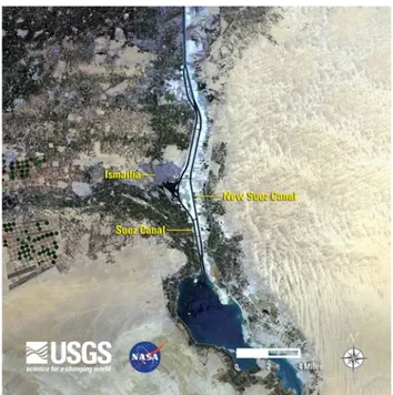
Anyway, the biggest challenge begins after the 2010. The Canal was not wide enough to allow two-way pas-sages of ships, although there were several passing bays and areas where ships may pass each other in the Bitter Lakes and between Qantarah and Ismailia (Fig. 1).
The Suez Canal has enjoyed increased traffic in recent years, with roughly 50 ships passing through its waters every day. However, the canal was still ham-pered by its narrow width and shallow depth, which were insufficient to accommodate two-way traffic from modern tanker ships (Akhter Hossain 2018). The idea of the “New Suez Canal project” dates back to the reign of President Sadat, particularly at the end of 1970s (Ken-awy 2016). However only in 2013 the project of $8,6 bil-lion expansion started.
On 5th August 2014, Egyptian President el-Sisi and the Suez Canal Authority (SCA) unveiled new plans for an additional lane to allow the transit of ships in both directions over a greater length of the canal (Fig. 1). The execution of the project was scheduled to end in 36 months, but this duration was tremendously cut short to 12 months. The new Suez Canal (completed on 6th August 2015) reinforces Egypt’s role as a major hub for global commerce.
According to the plan (Fig. 2), the New Canal reach-es 72 km in length. This includreach-es digging for 35 km with a depth of 24 m and a width of 320 m, the deepening
and widening of the western bypasses in the Great Bitter Lakes area (27 km in length) and the Al-Ballah western bypass (10 km in length) (Suez Canal Authority 2017).
The creation of a new canal, parallel to the existing one, doubling the longest possible parts of the waterway, allows to maximize the benefit from the previous config-uration in order to facilitate traffic in the two directions and to minimize the waiting time for transiting ships. This will increase the numerical capacity of the water-way, anticipating the world trade forecasts (Suez Canal Authority 2017).
Due to the potential increase in volume of world trade, the choice of Egypt was strategic to shorten both the transit and waiting time for vessels, which shall result in reducing the cost of the trip, thus attracting more ships that use the canal. All this contributes to raise the Suez Canal classification and to increase its competitiveness along the global East-West maritime route (Suez Canal Authority 2017).
In detail, the new infrastructure of the Suez Canal allows:
• an average reduction in travel times estimated at 11 hours per transit in both directions;
• an increase in daily transit capacity up to 97 ships (from the previous average of 49);
• no limits to megaships.
Considering the ship size capacity (in terms of ton-nage), after the enlargement the canal can accommodate Figure 1. The Suez Canal. Source: Smith, Fisher in Encyclopaedia
Britannica, 2015.
Figure 2. The Suez Canal’s doubling. Source: United States
up to 62% of world tanker fleet, 92% of bulk ships fleet, 100% of container ships fleet and all other kinds of ships (Suez Canal Authority 2017).
Building the second lane was necessary in order to increase the capacity of the Suez Canal, especially for southbound convoy that had to wait until northbound convoy passes through the waterway. The new solution cuts the transit time of the southbound vessels from 18 to 11 hours, thus, reducing their waiting time and the total cost of their entire trip (Suez Canal Authority 2017).
In February 2016, a new 8,5 kilometres long and 18,5 metres deep access channel was opened, linking the East Port Said directly to the Mediterranean Sea. This new channel provides a 24-hour access to East Port Said, eliminating the need for vessels heading for the Suez Canal Container Terminal to wait for up to 8 hours between convoys of ships transiting the Suez Canal.
The second lane reduces waiting time for transiting ships, facilitates traffic in two directions and increas-es the numerical capacity of the waterway. The drop in waiting times reduces fuel expenditures and costs for ship owners, attracting more ships (including mega-car-go vessels) to the waterway (Van Bemmelen et al. 2016).
The increased predictability in the timeliness of the transit in the Suez Canal, the strengthening of local transhipment hubs and the choice to avoid increasing the Canal’s fares (after the enlargement) will be three elements which will contribute to maintain the high lev-el of Canal’s competitiveness (Bacclev-elli et al. 2015).
The project’s objective was to maintain the strategic role of the Canal preserved within the geo-political pan-orama linked to international trade thus emphasizing the importance of Egypt among all major world markets (Baccelli et al. 2015).
As the shortest link between the East and the West, the Suez Canal is an important international navigation canal connecting the Mediterranean Sea at Port Said and the Red Sea at Suez, due to its unique geographical position (Van Bemmelen et al. 2016).
That is why the New Suez Canal project was initi-ated so that the importance and the significance of the Suez Canal as the biggest and the most important water-way in the world can be maintained.
It is also essential to note that the project was undertaken to carry out the aim of the Egyptian’s gov-ernment to raise the national economy (Van Bemmelen et al. 2016).
In this regard, the so-called “Suez Canal Corridor Area Project” (SCZone) plays a fundamental role. It represents a huge investment plan (located in the area around the Canal, to be completed in 2050) aimed at
the implementation of a regional development strat-egy through the expansion of the existing ports, the improvement of the logistic facilities and the creation of new industrial areas and research centres (Cresta 2017).
4. The world maritime traffic
Now that the evolution of the Suez Canal has been described, a brief overview of the characteristics of mar-itime traffic with its recent development and the flows deriving from it is to be introduced.
The aim is to depict the actual seaborne trade sce-nario in order to better understand the global role of the Suez Canal.
As markets became increasingly globalized, shipping volumes soared. From the 1950s to the latest global eco-nomic crisis, the growth rate of international trade has been almost consistently twice as big as that of economic activity as a whole (Maribus 2010).
The main reason behind the massive increase in shipping was the growth in world trade because of the redefined global production network.
Maritime shipping covers most of the movement of goods over long distances. This will continue to be the case in the coming years (ITF 2019). Marine industry is an essential link in international trade, with ocean-going vessels representing the most efficient, and often the only method of transporting large volumes of basic commod-ities and finished products (Gardiner 1992). We live in a global economy that simply could not function if it were not for seaborne trade: without maritime shipping, inter-continental trade would become impossible (IMO 2009). Maritime transport has played and continues to play a vital role in boosting international trade flows through cost reductions and technological improvements.
We can observe that in the last decades ships increased in size, became large, fast and highly special-ized: these innovations have helped to fuel the growth of maritime freight traffic. However, an overriding impor-tance may be attributed to containerization, resulting in the greatest transportation revolution of the 20th centu-ry (Maribus 2010) as an essential element of globaliza-tion processes (Fremont, Soppè 2005).
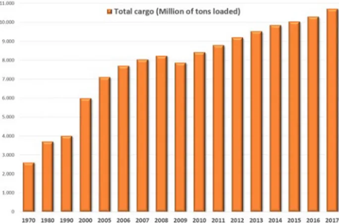
Because of the factors described above, the volume of maritime traffic increased significantly over the recent decades. Fig. 3 shows this trend of rapid growth in sea-borne trade. The maritime transport volumes grew by 4% in 2017, the fastest rate since 2012, while 10,7 billion tonnes were transported by sea that year.
If all commercial goods are taken into account it is clear that there is a relatively small number of
princi-pal transport routes, and these pass through only a few areas of the oceans (Maribus 2010).
As shown in the fig. 4, the geography of mari-time flows highlights the leading influence of Asia, as 42% (4,4 billion tonnes) of world maritime trade in 2017 originated in Asia and 61% (6,5 billion tonnes) was destined to the region. Other relevant regions, ranked in descending order, were Europe (respectively 1,8 and 2,1 billion tonnes), the Americas (respectively 2,3 and 1,4 billion tonnes), with a significant weight of Northern America (respectively 0,9 and 0,8 billion tonnes). These are the regions mainly involved in sea-borne trade: consequently, the busiest areas are the approaches to the ports of East Asia, Europe and the United States (Maribus 2010).
The Suez Canal is a choke point with a central posi-tion along the East-West trade route that connects the
Far East ports with those in Europe and North America (East coast).
Considering the world maritime trade forecasts and the canal’s strategic role, the Egyptian choice to expand the channel sounds like removing bottlenecks and rep-resenting a formidable challenge to the future seaborne trade evolution.
5. The Suez Canal traffic and main routes
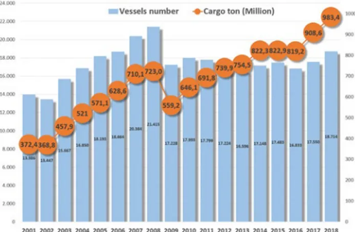
Considering the evolution of the Suez Canal traffic statistics, we can observe that in 1870 the quantity of ships passed through the canal reached the number of 485, in 1950 the number grew to 11.750 ships (82 mil-lion net tonnage), in 1960 the growth reached 18.750 ships (185 million net tonnage) while in 1966 the num-ber amounted to 21.250 ships (274 million net tonnage) (Panama Canal Company 1971).
After the canal’s closure in 1967, it was necessary to wait until 1980 to reach that level again. Fig. 5 shows the evolution of the Suez Canal traffic (in terms of ships number and of net tonnage) from 1975 (the year of re-opening) until 2018. Nowadays (2018), about 0,98 bil-lion tons of goods passed through the canal, nearly 9% of all global maritime trade (Suez Canal Authority 2019).
Similar to the Panama Canal, the Suez Canal experi-enced increasing capacity constraints and excessive wait times in recent years, which made the expansion project necessary. Between 2000 and 2014, the annual amount of cargo passing through the Suez Canal increased from 368 million tons to 822 million tons.
Average wait times for vessels transiting the canal were as high as 8 to 11 hours and were often unpre-dictable. Unpredictable wait times were especially trou-blesome for container ships, which accounted for more than 50% of Suez Canal traffic (Baccelli et al. 2015). Figure 3. World seaborne trade (selected years). Source: author’s
elaboration of UNCTAD data, 2018.
Figure 4. World seaborne trade, by region (global share), in 2017.
The present paragraph analyses the evolution of Canal traffic statistics highlighting the impact of the New Suez Canal realization. After the enlargement, traf-fic through the Canal has increased in double figures (SRM, Alex Bank 2018).
In 2014 (the last year before the enlargement), the daily average of transits was 47,0 ships and transiting net tonnage was 2.637,7 thousand tons. In 2018 the daily average of transits increased to 49,8 ships and that of net tonnage went up to 3.122,6 thousand tons.
The impact of the new Suez Canal is clear, in par-ticular considering the trend of cargo tonnage through the lanes: 822 million tons in 2014 that become 983 in 2018, with an increase by 19,6%. In general, the most recent dynamics (2001-2018) of freight traffic (Fig. 6) show that the first period (2001-2008) is characterized by an increase in the number of ships transited and the goods transported (by the same proportion). In the sec-ond period (2009-2015), it is possible to highlight a new tendency: the number of vessels decrease significantly in 2009 (-19,6% on behalf of 2008 data) and remain almost the same until 2014 and, on the other hand, the cargo flows increased in a considerable way (+47%).
The reason for this trend can be the impact of global economic crisis but also the phenomenon of the so-called “naval gigantism”, meaning fewer ships but of larger dimensions. In fact, after 2009, the cargo tonnage increased in a significant way: +75,8% in 2018.
The last three years (after the inauguration of the new Canal) show a similar trend but with a slight increase in number of vessels (+7%) due to the enhancements in traf-fic regulation and the reduction of transit times.
The dynamic shown in fig. 5 seems to confirm this trend because of the increase registered in the net
ton-nage (that consider not only the goods transported but also the ship net weight). In ten years (2009-2018), net tonnage increased by 55,2%.
Besides, it is important to analyse the ships and cargo traffic by type. Containerships, tankers and bulk carriers are the most common type of vessel passing through the Suez Canal. Measured in numbers of ships, containerships constitute about 31% of all the vessels and transport 55% of goods while oil tankers are respectively 26% and 18% and bulk carriers percentage is respectively 21% and 12% (based on 2018 data). The types of vessels that will take greater advantage from the new Canal will be the containerships (Panaro 2015).
Considering the statistics on the cargo type (Fig. 7), it is possible to underline the relevance of containerized cargo (that amounts to 53,5% of total cargo ton) and of oil and oil products (20,5%): together they account for about three quarters of the total traffic in the last decade (2009-2018).
In more detail, analysing the different direction of cargo typology, the major northbound cargoes con-sist of (in order of weight) containerized cargo, crude petroleum and petroleum products, liquid natural gas, oilseeds and vegetable oils, chemicals, coal, fabricated metals, fertilizers, machinery and parts, ores and met-als. Southbound traffic consists of containerized car-go, crude petroleum and petroleum products, cereals, ores and metals, fabricated metals, fertilizers, chemi-cals, liquid natural gas, coal, oilseeds and vegetable oils, machinery and parts.
The nature of traffic has greatly altered during times, especially because of the enormous growth in shipments of crude oil and petroleum products from the Persian Gulf since 1950. In 1913, the oil in northbound traf-fic amounted to 295.700 metric tons, whereas in 1966 it amounted to 168.700.000 metric tons. The closure of Figure 6. Vessels traffic and cargo tonnage of the Suez Canal
(2001-2018). Source: author’s elaboration of Assoporti and Suez Canal Authority data, various years.
Figure 7. The Suez Canal traffic by cargo type (2009-2018). Source:
the canal from 1967 to 1975 led large oil tankers to use the route around the Cape of Good Hope and prompt-ed the development of the Sumprompt-ed pipeline from Suez to Alexandria, which opened in 1977. Since 1975, the increased size of tankers (the largest of which cannot use the canal) and the development of sources of crude oil in areas outside of the canal route (e.g. Algeria, Lib-ya, Nigeria, the North Sea and Mexico) have partially reduced the canal’s importance in the international oil trade (Smith, Fisher 2015).
Anyway, in 2018 the oil and relative products amounted to 235.510.000 tons. A more recent feature has been the strong growth of containerships traffic through the canal (Cresta 2017). These flows originated from Southern Asia (India), Eastern Asia (China) and South-Eastern Asia (Singapore, Malaysia) and destined to the Mediterranean area and Northern Europe.
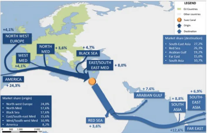
Speaking of origins/destinations and trade routes, it seems very interesting to analyse the characteristics of the commercial flows that have crossed the Suez Canal in recent years. The geographic interpretation of data allows us to highlight some useful observations (Figg. 8-9). In detail, we consider the cargo ton data by direction in the last ten years (2009-2018), mainly for two reasons:
• to verify the effect of global financial and economic crisis and its overcoming;
• to highlight the impact of the Suez Canal on the main East-West world routes.
North-South traffic has increased by 6,8% (this cate-gory accounts for 51,0% of the overall traffic of goods in the canal during the period in exam). The traffic in the opposite direction registered a similar annual growth (+6,6%). Along the North-South direction of the canal, South East Asia is still the main destination for tran-siting goods, accounting for 27,2% of the total (with an increase of 6,9% in 2009-2018). The Red Sea (26,3%) and the Arabian Gulf (19,2%) areas are relevant destinations of southbound flows. In particular the latter registered a significant +7,6% in 2009-2018.
In the opposite direction, the region of North West Europe holds the first place with a 32,6% share, followed by the East/South-east Mediterranean with a 23,5% share and by the North Mediterranean with a 19,9% share. The entire Mediterranean Sea stands for a 52,4% share. It is important to underline that flows destined to America are not residual (8,3%).
A look at the origin of goods reveals the dominant position of North West Europe along the North-South direction with its 24%, followed by the North Mediter-ranean (17,6%) and the Black Sea (17,6%). The former has increased by 8,5% and the latter has arisen by 9,7%. The entire Mediterranean Sea stands for a 44,1% share.
In the opposite direction the South East Asia leads the ranking with 36,1% (with an increase by 8,3% in 2009-2018), followed by the Gulf with 31,3% (with an increase by 11,5% in 2009-2018). Moreover, in this case the share of flows originated in America is significant and accounts for 8,2% (with an increase by 24,3% in 2009-2018). All origins and destinations are character-ized by positive trends (with the only exception of the Far East as origin of northbound traffic): this means a progressive recovery after the big fall in 2009. The flows data illustrated in figg. 8 and 9 highlight the strategic importance of the Suez Canal as an international hub along the global routes.
In this respect, Notteboom e Rodrigue (2011) point out that in the last few years new challenges arose for
Figure 8. Growth of southbound cargo traffic through Suez by
mar-kets of origin and destination (annual average variation 2009-2018 and total market share). Source: author’s elaboration of Suez Canal Authority data, various years.
Figure 9. Growth of northbound cargo traffic through Suez by
mar-kets of origin and destination (annual average variation 2009-2018 and total market share). Source: author’s elaboration of Suez Canal Authority data, various years.
the Suez Canal as an intersection of the traffics between East and West. The building of the new Canal allows faster transit times along the intercontinental East-West connection between Asia, the Middle East, Europe and the East coast of the United States (Baccelli et al. 2015).
In fact, we observe an increase in number of vessels passing through the Canal and above all in goods trans-ported, further reinforcing the importance of Suez with-in the geo-political panorama lwith-inked to with-international trade.
6. The role of the Suez Canal for the Mediterranean Sea
The Euro-Mediterranean’s most important geostra-tegic point is for sure the Suez Canal (along with three natural straits: Gibraltar, Bosporus and Dardanelles). Indeed, it represents the shortest seaway from East Asia and the Middle East to Europe as well as for some Afri-can states to Europe (Gaiser, Hribar 2012).
In order to understand the actual Mediterranean strategic relevance, it is important to look back in the last decades and consider the evolution of the global maritime traffic.
During the eighties and nineties the increase in international trade, accelerated by liberalization and opening of markets, has been the key driver of the expansion of containerization. In the late eighties, some countries such as the Asian Tigers began to emerge hence promoting the development of container traffic thanks to the type of production and the intensity of the flows. A model dominated by the old industrialized countries (North America, Japan, Western Europe) has undergone a transformation in a model that sees the ports with the largest share of container traffic mainly located in Asia (Guerrero, Rodrigue 2014).
In the nineties, a large increase of ships coming from Eastern Asia and directed to the US East coast significantly contributed to the saturation of the Pan-ama Canal by encouraging the use of the Pendulum routes (Far East – Mediterranean and Northern Europe – North America) which, along the Suez-Gibraltar axis, provide a round and a return following the same route (Fig. 10). On these routes, the Far East is connected to the East Coast of the United States by crossing the Medi-terranean (Amato, Galeota Lanza 2016).
As Foschi recalls (2003), in the eighties, the Medi-terranean was considered a market apart that was sep-arately connected to Asia, North America and Northern Europe. The liner shipping companies who normally worked on the main routes between the Far East and North America or Northern Europe also deployed ships
dedicated specifically to services with the Mediterra-nean. The physical routes and the organizational ineffi-ciency or the excessive distance from the optimal route resulted in real physical-economic barriers for the big ships in transit (Foschi 2003).
The evolution in containerized cargo and its expo-nential growth determined a radical change in one strategical area: the Mediterranean Sea. In fact, during the nineties, the biggest container shipping companies decided to incorporate the Mediterranean in the ocean-ic routes, because of a number of contributory causes, intrinsic to the world linear shipping industry and inter-national commerce (Foschi 2003; Landini 2017).
The global transformation of maritime container traffic was destined to produce significant effects on the southern Europe ports (Sellari 2014).
In 1995, the transpacific route ruled the market, controlling 53% of the global traffic, while the Europe– Far East, which connected the European markets to the Chinese manufacturing sites through the Suez Canal and the Mediterranean, absorbed only 27% of the mar-ket (Fardella, Prodi 2017).
Twenty-three years later, the distance between these two routes dropped in favour of the Europe–Far East one that today controls 41% of global traffic in the face of 46% of the transpacific route (UNCTAD 2018; Dean-dreis 2018).
In 2018, the Far East-Europe was the second biggest trade lane (behind the transpacific), accounting for 25 million of TEUs traffic. As a result of this growth, the Mediterranean basin and its ports recovered their own “centrality”, thanks to the transit of (almost) all mother vessels via the route Suez (Deandreis 2018). This new cen-trality of the Mediterranean emerged due to the parallel impact of three concurrent factors (Fardella, Prodi 2017): • the expansion of the Suez Canal in August 2015 that
doubles the daily capacity of cargo transit, reducing Figure 10. The major East-West global container routes. Source:
at the same time the waiting time and the transit costs;
• the emerging “naval gigantism” or the strategic use by the main shipping companies of huge vessels (between 13.000 and 22.000 TEUs) that can only be hosted by the Suez Canal1;
• the acceleration of global alliances made by shipping companies to strengthen their economies of scale. These three concurrent phenomena are progressive-ly reinforcing the competitive advantage of the Europe-Far East route, making it even more convenient than the transpacific route for the Chinese cargo directed towards the North-Eastern coast of the USA. These processes provide the Mediterranean with an unprecedented “cen-trality” within both of the China’s most important trade segments with Europe and the USA (Fardella, Prodi 2017).
Because of this evolving scenario, the container traf-fic in the Mediterranean has grown sixfold over the last 20 years (+500%) and the top 30 Mediterranean ports have handled 53 million TEUs (this figure amounted to 9 million in 1995) (SRM 2018).
More generally, it is important to underline that in the last years (between 2001 and 2018), the volume of freight traffic that crossed the Suez Canal jumped by 164%, with the Mediterranean controlling almost 9% of the global trade.
This transformation, propelled by the epoch-mak-ing growth of the Chinese market, seems to be havepoch-mak-ing a virtuous impact on commercial, infrastructural and logistical dynamics in the Mediterranean. In 2001, the Mediterranean ports managed to attract a mere 34% of the goods that passed through the Suez Canal. All the rest left the Mare Nostrum through Gibraltar and was absorbed by Northern European ports such as Rot-terdam and Hamburg (Fardella, Prodi 2017). Howev-er, today (2018), 64% of the same traffic remains in the Mediterranean Sea.
7. The role of the Suez Canal for the North Italy ports: the case of Genoa
In literature arose the question of whether it is still necessary to identify sub-areas within the Mediterra-nean or whether the global nature of maritime transport makes this distinction superfluous. Some peculiarities of these sub-regions suggest that it is still necessary for
1 The Suez Canal has no restrictions on the passage of containerships
(unlike Panama). Average vessel size via Suez reached 9.100 TEUs in September 2018; the highest value ever-achieved (SRM, Alex Bank 2018).
them to be treated as distinct areas, although on the way towards integration. By distinguishing these differ-ent areas, it is possible to give a clearer analysis of the aspects that influence their development and of the crit-ical factors to be taken into consideration in planning activities (Foschi 2003). In this paper, we are interested in a specific sub-area: the Northern Mediterranean.
As mentioned above, main cargo flows northbound/ southbound through the Suez Canal underline the importance of this zone. In particular, during the peri-od of 2009-2018, the ports of this sub-area have a 17,6% share of the southbound traffic and a 19,9% share of the northbound traffic..
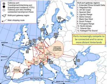
A typical characteristic of the Northern Mediter-ranean is the presence of important gateway ports (Fig. 11) (Notteboom 2009; 2010). These ports are nodes with a connected hinterland that is rich in production and consumption and constitute the international access/exit points for the regions supporting them (Foschi 2003).
If they have suitable physical, technical and infra-structural characteristics, the large ocean-going ships with international traffic can call at these ports. Oth-erwise, both on the East-West route and the North-South route, they can serve small ocean ships perform-ing regional and interregional cabotage services (short sea shipping) or carry out feeder services in a hub and spokes system (Foschi 2003).
In the Northern Mediterranean, the ports situated along the Tyrrhenian cost (Savona, Genoa, La Spezia and Leghorn) are predominantly involved in gateway functions (Portopia 2017) and form a multi-port gateway region (the so-called Ligurian Range) (Notteboom 2009; 2010).
Figure 11. The European container port system. Source: author’s
Italy is one of the European countries that could benefits more from the new Suez Canal because of the strategic position at the centre of the Mediterranean and the growing importance of trade between the Far East and North America (Deandreis 2015). As shown in fig. 12, the main flows from Suez (or directed to) pass through the Sicily Strait but a part of them is attracted by the Northern Tyrrhenian ports.
In detail, these ports have some specific advantages (illustrated in fig. 11):
• savings of no less than five days in reaching the Northern range European ports for freight arriving from the East;
• configuration as the Southern terminals of Rhine-Alps European corridor;
• potential customer base extending from Northern Italy to Switzerland, Austria and Bavaria.
On the other hand, it is necessary to consider some critical factors such as the difficulty of rail transit, the optimization of intermodal processes and the physical barrier constituted by the Alps (Foschi 2003).
Anyway, in the last years, the Northern Italy ports (and the Ligurian ones in particular) are growing, the reform of ports governance has shown the first posi-tive consequences and there is a renewed awareness of a potential key role for Italy in the new geo-economic sce-nario (SRM 2018).
The final goal of this paper is to describe, as Pana-ro suggested (2015), how the new infrastructure of the Suez Canal is considerable for the Northern Italy gate-way ports.
As written above, typical gateway ports are points of entry or exit for continental markets and they are pref-erably well-connected to large industrial and population centers. Mediterranean examples include the Northern
Italy ports, which can be seen as a cluster of gateways (Wolters 2016).
The expanded Suez Canal can transport more ves-sels, allow passage for larger megaships and reduce trip’s time and costs. These factors represent a new opportuni-ty for global shipping ports, for the gateway ones in par-ticular because of their connections with several inland logistics hub (Wolters 2016).
We focused our attention on the Genoa port, located in Northern Italy. It lies along a 22 km coastline, has 21 private operating terminals, equipped to receive vessels for all types of goods: containerized cargo, perishable products, metals, forest products, dry bulk and oil prod-ucts. The present structure has emerged in 1997 with the opening of a new western part, the Voltri Terminal Europa (VTE) dedicated to container handling.
Genoa is the first Italian container port in 2018 (2,6 million of TEUs) and the second port for total car-go (54,2 million of tons) behind Trieste (62,7 million of tons). It plays the role of a gateway port, as a terminal for import-export container flows serving the companies of North-Western Italy (Torbianelli, Borgogna 2012). Genoa is the greatest gateway port in Italy for deep-sea contain-erized traffic (with direct connections), regarding both the number of monthly ship departures and the freight volumes (Lupi et al. 2019).
Deep-sea traffic originated from Asia and directed to Europe passes necessarily through the Suez Canal. Therefore, the Genoa port is the target of a large share traffic from Suez (Baccelli et al. 2015). In 2014 (the year before the Suez Canal doubling), the Genoa port had a 7% of market share on the trade lane Far East-Mediter-ranean and an average vessel capacity of 10.000 TEUs (ITF 2015).
In the last years, the growth of the Genoa port is an effect of the ever-greater importance taken by the Medi-terranean in the global scenario of freight by sea. A rele-vance that goes along with the increase in trades to and from the Far East, through the Suez Canal, whose dou-bling (in August 2015) favoured this path (Corva 2019).
In this regard, the paper investigates the recent dynamics of the Genoa port using the traffic statistics in order to evaluate the role of goods flows passing through Suez.
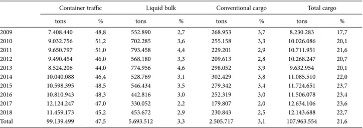
The analysis of the freight flows from/to the Suez Canal in the last ten years (2009-2018) underlines some interesting facts (Table 1).
First of all, “the Suez’s share” accounts for 21,6% of total cargo traffic and for 47,5% of the containers han-dled. Therefore, it looks definitely relevant.
In ten years, the Genoa port handled almost 108 million tons of traffic passed through the Suez Canal. In Figure 12. The containership density and the main container ports
detail, considering the typology of goods traded, con-tainerized cargo represents 91,8% of total goods traded via Suez.
The evolution of total cargo traffic related to Suez registered an increase by 67,2% from 2009 to 2018.
Similarly, there was a significant boost in container traffic related to Suez (+54,7%) and an annual growth of 2,7% after the expansion of the Suez Canal (2015). In particular, the rise of freight flows concerns the years 2009-2011 and 2013-2017. The data of 2018, on the other hand, fell by 5.5%.
In the period of 2009-2018 the Genoa container ter-minals (VTE, Sech, Spinelli, Messina, San Giorgio) han-dled a total of 9,4 million of TEUs passed through Suez.
Liquid bulk and conventional cargo shares are resid-ual (respectively 3,3% and 3,1%). These have undergone a
decrease in the last four years, even if in 2018 the trend switched to the opposite.
The analysis of the geographic distribution of the flows allows to underline how the Far East’s traffic results to be prominent. In fact, it is possible to highlight that in the last ten years (2009-2018) the flows from/ to the Eastern Asia reached the 66% of the total traffic through Suez and, in particular, container flows repre-sented the 68% of the total containerized cargo.
Therefore, the distribution of the major ports con-nected with Genoa (cargo traffic and container) appears to be coherent with the data exposed above (Fig. 13). Indeed, they are mainly located in the Far East or in the Asian context (with the Middle East growing fast).
Conclusions
The expansion of the Canal will positively affect naval traffic and trade, representing an opportunity for enterprises and for shipping companies. The former will have a chance to count on more rapid freight flows and therefore on better processes of internationalization, the latter will be able to streamline routes and logistic sys-tems (Baccelli et al. 2015).
In relative terms, the main beneficiaries will be long-range flows (China-Mediterranean-East Coast of the United States) of containerized cargo. All this will increase the centrality of the Mediterranean Sea and of the Northern Italy gateway ports.
Genoa is the main gateway port of Italy. The data illustrated in the previous paragraph show that the traf-fic passing through the Suez Canal, in particular the Table 1. Genoa port: share of traffic (per type) coming from/directed to the Suez Canal (2009-2018). Source: author’s elaboration of data of
the Port System Authority of Western Ligurian Sea, various years.
Container traffic Liquid bulk Conventional cargo Total cargo
tons % tons % tons % tons %
2009 7.408.440 48,8 552.890 2,7 268.953 3,7 8.230.283 17,7 2010 9.032.756 51,2 702.285 3,6 255.158 3,3 10.026.086 20,1 2011 9.650.797 51,0 793.458 4,4 229.201 2,9 10.711.951 21,6 2012 9.490.454 46,0 568.180 3,3 209.613 2,8 10.268.247 20,7 2013 8.524.206 44,0 774.956 4,6 298.052 3,9 9.632.954 20,1 2014 10.040.088 46,4 528.769 3,1 302.429 3,8 11.085.510 22,0 2015 10.598.395 48,5 546.434 3,5 279.342 3,4 11.724.651 23,7 2016 10.810.943 48,3 442.816 3,0 252.319 3,0 11.506.078 23,4 2017 12.124.247 47,0 330.052 2,2 179.807 2,0 12.634.106 23,6 2018 11.459.173 45,2 453.672 2,9 230.843 2,5 12.143.688 22,7 Total 99.139.499 47,5 5.693.512 3,3 2.505.717 3,1 107.963.554 21,6
Figure 13. Major ports connected with the Genoa port through the
Suez Canal (cargo and container traffic). Source: author’s elaboration of Port System Authority of Western Ligurian Sea data, various years.
container flows, is very significant for the Genoa port. In addition, the recent expansion of the canal has posi-tively influenced the amount of freight handled in port. The growth in cargo traffic and forecasts of a further increase in the coming years are, at the least in part, due to the impact of the new Suez Canal.
Outlining the future scenario and development opportunities for Genoa seems inevitable to consider the current investment framework represented by the “Belt and Road Initiative” (BRI) launched in 2013 by China.
The BRI is an infrastructural investment program that aims to develop connectivity and collaboration between China and seventy countries, creating an integrated Eur-asian economic area. Through transport corridors (by land and by sea), it will allow China to diversify trade routes and to intensify existing relations with the EU.
It should be highlighted that the choice of China is to orient part of the investments of the BRI program precisely on the maritime route that passes through the Suez Canal and Mediterranean.
In this regard, the key project for Genoa is the relo-cation of the port breakwater included in the memoran-dum signed in Rome by Chinese President Xi Jinping on 23rd March 2019.
This realization would allow the port to host larger containerships (in line with the tendency to the naval gigantism described above), to increase the volume of containerized cargo handled and to improve its role of a gateway node.
This infrastructural option (supported by China) is the result of the recognition of Genoa as a terminal of the Silk Road for Western Europe (together with Trieste for Eastern Europe).
The choice of Beijing to focus on two Italian ports is based on economic, strategic and geographical evalu-ations.
Considering the current distribution of freight in Europe as well as the growth of the route Europe-Far East via Suez, the position of the two Italian ports is strategic. In fact, both are connected with European Corridors: Genoa with the Rhine-Alps one and Trieste with the Baltic-Adriatic one (Romei 2017).
For these reason, the two ports are much closer to the center of Europe than other Italian ports but also European ports (in which China has already invested, see Greece with Piraeus and Spain with Valencia).
All with obvious geo-political effects facing the importance of the Chinese choice to aim at conquering the European market thanks to Genoa’s strategic posi-tioning.
Therefore, the path of strengthening the China-Italy route via Genoa seems to be traced as well as the
conse-quent empowerment of the role of the Ligurian capital. The future challenge for Genoa is to enhance its function as a gateway port to Central-western Europe by subtracting market shares to the North European ports.
References
Akhter Hossain, K. (2018). Suez Canal: The Modern Mari-time Wonder. International Journal of Scientific Research in Environmental Science and Toxicology, 3 (3), 1-10.
Amato, V., Galeota Lanza, G. (2016). The Mediterranean as a Hub of Maritime Trade and the Role of the New Suez Canal. Sfera Politicii, 2, 86-102.
Arab World Institute (2018). The epic of the Suez Canal. From the Pharaos to the 21st Century. Paris, Press kit. Assoporti (2018). Canale di Suez. Transito navi, tonnella-te di merci e numero contonnella-tenitori. Roma, Associazione dei Porti Italiani. Retrieved from http://www.assoporti.it/it/ autoritasistemaportuale/statistiche/statistiche-mondiali/ transiti-canale-di-suez/
Baccelli, O., Buonfanti, A., Ferrara, O., Zucchetti R. (2015). The new Suez Canal: economic impact on Mediter-ranean maritime trade. Naples, Permanent Observatory on Maritime Transports and Logistics.
Bencardino, F., Giordano, A. (2017) (a cura di). Amplia-mento del Canale di Suez: possibili benefici per il sistema Italia e politiche per una loro massimizzazione. Ricerche e Studi (28). Roma, Società Geografica Italiana.
Black, W. (2003). Transportation: A Geographical Analysis. New York, Guilford Press.
Charlier, J., De Meyer, C., Paelinck, H. (2015). Introduc-tion. In Charlier J. et al. Interoceanic Canals and World Seaborne Trade: Past, Present and Future. Brussels, Royal Academy for Overseas Sciences, 5-9.
Corva, L. (2019), Strategie di attracco. IL Magazine - Il Sole24Ore. Milano, 18 marzo 2019, 48-53.
Cresta, A. (2017). Il Canale di Suez: dalla progettualità agli impatti territoriali. In Bencardino, F., Giordano, A. (2017) (a cura di). Ampliamento del Canale di Suez: pos-sibili benefici per il sistema Italia e politiche per una loro massimizzazione. Ricerche e Studi (28). Roma, Società Geografica Italiana, 33-53.
Dávid, A., Piala, P. (2016). The strategic maritime canals and straits. Perner’s Contacts, 11 (2), 5-10.
Deandreis, M. (2015). The New Suez Canal. Presenta-tion of the special report The New Suez Canal:
Econom-ic Impact on Mediterranean Maritime Trade. Cairo, 29th November 2015.
Deandreis, M. (2018). The role of ports and the Mari-time sector. Presented at the Second Italian Arab Business Forum. Rome, 17th October 2018.
Dobruszkes, F. (2012). Stimulating or frustrating research? Transport geography and (un)available data. Belgeo - Revue belge de géographie (on-line), 1-2, 1-15. Fardella, E., Prodi, G. (2017). The Belt and Road Initia-tive Impact on Europe: An Italian PerspecInitia-tive. China & World Economy, 25 (5), 125-138.
Foschi, A.D. (2003), The maritime container transport structure in the Mediterranean and Italy, Dipartimento di Scienze Economiche – Università di Pisa, Discussion Paper n. 24.
Fremont, A., Soppè, M. (2005). Transport maritime con-teneurisé et mondialisation. Annales de géographie, 642 (2), 187-200.
Gaiser, L., Hribar, D. (2012). Euro-Mediterranean Region: Resurged Geopolitical Importance. International Journal of Euro-Mediterranean Studies, 5 (1), 57-69.
Gardiner, R. (Ed.) (1992). The Shipping Revolution. Lon-don, Conway.
Greco, I., Cresta, A. (2018). La geopolitica dei mari e la “Guerra” dei canali e dei nuovi passaggi marittimi e terre-stri. In Fuschi M. (a cura di). Barriere/Barriers. Memorie geografiche NS 16, 125-132.
Guerrero, D., Rodrigue, J-P. (2014). The waves of contain-erization: shifts in global maritime transportation. Journal of Transport Geography, 34, 151-164.
Hesse, M., Rodrigue J-P. (2004). The transport geography of logistics and freight distribution. Journal of Transport Geography, 12, 71–184.
Hoyle, B., Knowles, R. (1998), Transport geography: an introduction. In Hoyle, B., Knowles, R. Modern Transport Geography, Chichester, Wiley, 1-12.
International Association of Dredging Companies (IADC) (2003). The Suez Canal - Camels, Sand and Water. Terra et Aqua, International Journal on Public Works, Ports & Waterways Developments, 93, 24-25. International Maritime Organization (2009). Internation-al Shipping and World Trade. Fact and Figures. London, Maritime Knowledge Centre.
International Transport Forum (2015). The Impact of Mega-Ships. Paris, OECD Publishing.
International Transport Forum (2019). ITF Transport Outlook 2019. Paris, OECD Publishing.
Kenawy, E. M. (2016). The economic impacts of the new Suez Canal. In IEMed. Mediterranean Yearbook 2016. Barcelona, IEMed, 282-288.
Knowles, R.D., Shaw, J., Docherty, I. (2008). Introduc-ing Transport Geographies. In Knowles, R.D., Shaw, J., Docherty, I. (Eds.). Transport Geographies: Mobilities, Flows and Spaces. Oxford, Blackwell, 3-9.
Landini, P. (2017). Sviluppo dei traffici intermodali e cen-tralità del Mediterraneo. Presented at Economia del mare e rilevanza della portualità. Ortona, 24th February 2017. Lewis, A. (1992). The Role of Choke Points in the Ocean Context. GeoJournal, 26 (4), 503-509.
Lupi, M., Pratelli, A., Licandro, C., Farina, A. (2019), The evolution of deep sea container routes: the Italian case. Transport Problems, 14 (1), 69-80.
Maribus (2010). World Ocean Review 2010. Hamburg, Maribus.
Notteboom, T. (2009). An economic analysis of the Euro-pean port system: report for the EuroEuro-pean Sea Ports Orga-nization (ESPO). Antwerp, ITMMA – University of Ant-werp.
Notteboom, T. (2010). Concentration and the formation of multi-port gateway regions in the European container port system: an update. Journal of Transport Geography, 18 (4), 567-583.
Notteboom, T., Rodrigue, J-P. (2011). Challenges to and challengers of the Suez Canal. Port technology interna-tional: the review of advanced technologies for ports and terminals world-wide, 51, 14-17.
Ogen, O. (2008). The economic lifeline of British global Empire: a reconsideration of the historical dynamics of the Suez Canal, 1869-1956. The Journal of International Social Research, 1 (5), 523-533.
Panama Canal Company (1971). Panama and Suez Canals. General Comparative Statistics. Panama.
Panaro, A. (2015). The new Suez Canal. Presented at the Conference Shipping and the law. Naples, 15th October 2015.
Panaro, A., Ferrara, O. (2018). Gli investimenti cinesi, la nuova centralità del Mediterraneo e il ruolo dell’Italia. Orizzonte Cina, 9 (1), 8-14.
Port System Authority of Western Ligurian Sea (from 2009 to 2018). Port of Genoa – Traffic statistics. Genoa, Port
Sys-tem Authority of Western Ligurian Sea. Retrieved from http://servizi.porto.genova.it/en/traffici/statistiche.aspx Portopia (2017). European Port Industry Sustainability Report 2017. Brussel, Vrije Universiteit. Retrieved from http://www.portopia.eu/wp-content/uploads/2017/11/ FINAL-Sustainability-Report-2017.pdf
Rodrigue, J-P. (2004). Straits, Passages and Chokepoints: A Maritime Geostrategy of Petroleum Distribution. Cahiers de géographie du Québec, 48 (135), 357-374. Rodrigue, J-P., Browne, M. (2008). International Mar-itime Freight Movements. In Knowles, R.D., Shaw, J., Docherty, I. (Eds.). Transport Geographies: Mobilities, Flows and Spaces. Oxford, Blackwell, 156-178.
Rodrigue, J-P., Comtois, C., Slack, B. (2006). The Geogra-phy of Transport Systems. New York, Routledge.
Romei, F. (2017). Il Canale di Suez: dalla progettualità agli impatti territoriali. In Bencardino, F., Giordano, A. (2017) (a cura di). Ampliamento del Canale di Suez: pos-sibili benefici per il sistema Italia e politiche per una loro massimizzazione. Ricerche e Studi (28). Roma, Società Geografica Italiana, 109-139.
Sellari, P. (2013). Geopolitica dei trasporti. Bari, Editori Laterza.
Sellari, P. (2014). Il Mediterraneo nella geopolitica dei traffici marittimi. Gnosis – Rivista Italiana di Intelligence, 3, 99-105.
Smith, C.G., Fisher, W.B. (2015). Suez Canal. In Encyclo-paedia Britannica. Retrieved from www.britannica.com/ topic/Suez-Canal
SRM (2018). Italian Maritime Economy – 5th Annu-al Report, China, Energy corridors, ports and new routes: geomaps of a changing Mediterranean. Naples, Permanent Observatory on Maritime Transports and Logistics. SRM, Alex Bank (2018). The Suez Canal after the expan-sion. Analysis of the traffic, competitiveness indicators, the challenges of the BRI and the role of the Free Zone. Naples, Permanent Observatory on Maritime Transports and Logistics.
Suez Canal Authority (2017). New Suez Canal. Ismailia, Suez Canal Authority. Retrieved from www.suezcanal.gov.eg Suez Canal Authority (2019). Suez Canal Traffic Statis-tics. Annual Report 2018. Ismailia, Suez Canal Authority. Retrieved from www.suezcanal.gov.eg
Suez Canal Authority (from 2009 to 2018). Suez Canal Traffic Statistics. Annual Reports. Ismailia, Suez Canal Authority. Retrieved from www.suezcanal.gov.eg
Torbianelli, V.A., Borgogna, F. (2012). La geografia dei flussi economici nei porti italiani 2003-2010 e le disparità regionali. XXXIII Conferenza Italiana di Scienze Regiona-li, Roma, 13-15 settembre 2012.
Ullman, E., Mayer H. (1954). Transportation Geography. In James, P., Lones C. (Eds.), American Geography: Inven-tory and Prospect. Syracuse, Syracuse University Press, 311-332.
United Nations Conference on Trade and Development (UNCTAD) (2018). Review of Maritime Transport 2018. Geneva, United Nations.
United States Geological Survey (USGS) (2015). Suez Canal Expansion. Retrieved from https://eros.usgs.gov/ views-news/suez-canal-expansion
Vallega, A. (1997). Geografia delle strategie marittime. Milano, Mursia.
Van Bemmelen, B., Dhont, W., Farouk Eid, O., Nagel, M., Willems, K. (2016). Challenge in logistics, New Suez Canal Project. Terra et Aqua, International Journal on Public Works, Ports & Waterways Developments, 143, 5-13.
Wolters, M. (2016). New Suez Canal creates opportunity for Mediterranean hubs. Los Angeles, CBRE Research, 6th May 2016.