TO PROJECT IN A BORDER ENVIRONMENT
BEIRUT - LEBANON
Politecnico di Torino
Abstract
This Thesis is willing to show you the devolution of a city that survived fifteen years of civil war and society damage; the unsustainability of destruction and the deep lost of collective memory; to remember the city that we had and to forget how we lost it.
CONTENT
1- Introduction...06
2- Localization ...08
2.1- Lebanon in the world ...09
2.2- Beirut in Lebanon ...11
3- ¿Why war?...12
3.1- Historic timeline...12
3.2- Lebanon’s role in civil war...17
3.3- Green Line...19
4- Beirut before and after civil war...22
4.1- “The Paris of the middle east”...24
4.2- The nature of destruction and the failure of the post conflict rehabilitation...34
5- THE EGG - Big City Center ...50
6- The show isn’t over – the intervention .. ...67
6.1- Analysis...68 6.2- Urban proposal...78 6.3- Architectural proposal...91 6.4- Project schemes...105 6.5- Project views...114 6.6 - Conclusions...123 6.7 - The Process...124 7- Bibliography...130
1. Introduction
After the independence of Beirut from the French mandate the city had reached a successful urban design model who was ready to be improved with the new politics; In the early 60s Beirut was on top in terms of tourism, economics, and political liberalism, it was the golden age of architecture and urbanism of the city; the city center was full of souks of all types, fabrics, carpets, manufacturing, apparel, food, shoes, jewelry and more from the local industry; it was also growing with the construction of banks, clinics, hotels, cinemas and nightclubs. Between 1975 and 1991 civil war happened, and all social, economic, administrative and political structure were destroyed; in the precedent years the city had reached a huge development and between these years it stopped completely.
The armed conflict was a massive human rights violation and people had to migrate from one side to another; the periphery of the city started growing by displaced populations without any plan, violation of building codes, construction codes and property rights regulation; it was a need.
10% of the constructions of Beirut and its suburbs were destroyed, taking with them the physical infrastructure of the country (water, electricity, roads) and the city center heritage; the city infrastructure still a problem after war, and the city heritage was something that can’t be brought back, it was gone.
After war in 1991 the reconstruction of the city was the plan, but what was supposed to be rebuild and planned by the public sector was
taken by the private, who took advantage of the bankrupt government making the city center project a business for sell to foreigners; Solidere was the company on charge of the Beirut Central District project managed by Rafik Hariri; in the hurry of building their business they deleted most of the heritage that had survived war and what was left was renovated using them as shops for big international brands, forgetting that the city center was before a complex of souks of local merchants.
Not only the functionality of the city center had changed, but also its scale; the memory of the city was deleted as a tabula rasa, and what came later wasn’t even made by Lebanese hands, the company contracted big international offices as Herzog & de Meuron, Daniel Libeskind, Jean Nouvel and other prestigious architects that without doubt made beautiful and interesting projects, but they don’t belong to the city, they could be placed anywhere else because they don’t respond to the context, to the history or even to the citizens needs, they are just big empty boxed owned by some Saudi or emirate that doesn’t even care of the piece of city that they have; for them is just an investment.
The big city center was a project made by the Lebanese architect Joseph Philip Karam and is part of the Beirut central district area, the construction stared in 1965 as a multi-user complex that was claimed to be the largest
a cinema with a form of an egg shell that still decaying nowadays.
The leftovers of the city center have become an icon to the city; ruins in between all the luxurious building that surround it; some claim that if should be destroyed, some others claim that is an important picture of the city, a place that remember how was Beirut before war and saw it suffer during it.
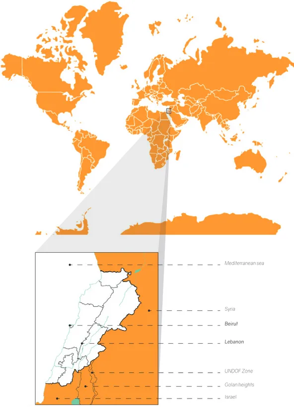
Mediterranean sea Syria UNDOF Zone Golan heights Israel Beirut Lebanon
2. Localization
2.1- Lebanon in the world
Lebanon is a small country located in the middle east region having a long coastline of the Mediterranean Sea, sharing borders with Syria and Israel; its capital is Beirut, a port city located in the center of Lebanon’s coastline. Lebanon is located in the Mediterranean zone, having a cold winter season from January to march, a hot summer season from July to September and a mild mid season from April to June and from October to December.
Climates in the world (Historicair, 2006)
In figure 1. there’s also localized the UNDOF zone, witch means United Nations Disengagement Observer Force that was an implementation of the United nations security to maintain the ceasefire between Israel and Syria in 1974.
Languages: Arabic (official), French, English, Armenian
Ethnic Groups:
Religion:
Government: Parliamentary republic Independence: 22 November 1943 Area: 10,400.00 km2
Water Area: 170.00 km2 Land Area: 10,230.00 km2 Population: 6,237,738.00
Arab 94% Armenian 4% Other 1%
Muslim 54% Christian 40.4% Druze 5.6%
Beirut city
Greater Beirut Figure 2.
2.2- Beirut in Lebanon
The city of Beirut was conquered by many empires and mandates because of its long coastline witch made it easy to enter to the territory; the diversity of the city nowadays is the result of these settlements through time.
Phoenician (1200-500 BC) Roman (64 BC - 395 AD) Medieval (1300-1500) Ottoman (1516-1920) French mandate (1920-1943) War time
The city flourished as a big port with exportations to the countries nearby.
The city was organized with the Gridiron Plan, which consisted in inserting main streets making a grid with buildings as forum, thermals, temples, basilicas, shops, markets, theaters and the University of law.
“The city was taken over by Islamic rule; buildings such as mosques, khans (rest houses), public baths, and souks were soon evident within the fabric”.
Major civic buildings were erected during the beginning of this period; the port gained importance and was called at that time “Port of the Levant”.
“New buildings types emerged, ranging from hotels, to banks, to department stores”.
Beirut became a prominent city in the banking and trade industries.
“New building types once again were evident within the city: Parliament, exhibition pavilions, cinemas, and industrial buildings (silk factories). The architectural style of this period was that of stylistic pluralism, addressing neo-traditional, neo-ottoman, and French styles.”
Important urban design model: Place de l’Etoile.
1920 1967
1943
1975
1926 1968
1948
April- World war I ended and the ottoman empire had fallen; France gets to
manda-te over Greamanda-ter Syria September- Greater Syria get divided into Syria and Lebanon by the French
mandate.
Lebanon creates its constitution dividing
the power between religious groups Israel started attacking Lebanon because of their support to the Palestinian (the attacks continued for six more years); in the next year Lebanon and the PLO signed the Cairo Agreement that consisted in giving to the PLO extraterritorial rights. Christians
Sunni Muslims
Shia Muslims Lebanon gains independence from France and three years later in 1946 French troops
withdraw completely.
Civil war started because of the tension between Christians and Muslims that was provoked by attacks from one group to another; on April 13 a Christian church was attacked killing four people, and the day after the attack 27 Palestinians died in a
bus ambushed. Parties Maronite Christians – LF
(Lebanese forces) – they wanted to end the Palesti-nian extraterritorial rights
LNM
(Lebanese National Movement) – groups that sympathized with
Palesti-nian goals.
The Arab-Israeli war provoked the migration of many Palestinians into
Lebanon.
After the outbreak of the six days’ war a second group of Palestinians take refuge
in Lebanon.
PLO (Palestinian liberation organization) uses the country as a base for attacks on
Israel.
Lebanon does not participate.
3. ¿Why war?
1990
Aoun is defeated by the Syrian forces and they forced him to take refugee in the
French embassy in Beirut.
1982
Israeli ambassador Shlomo Argov was assassinate in London for what they claimed was an act from the PLO but the
international community’s doubted it. Israel invades Lebanon in the following
1984
U.S marines leave Lebanon because of a military attack made by two Shia groups
that killed 271 U.S and 56 French.
1991
All militias are dissolved, with the excep-tion of Hezbollah (Shia military group
supported by Iran)
“A principal reason for the end of active hostilities was the exhaustion brought on
by the fifteen years of war fire”
1948
The Arab-Israeli war provoked the migration of many Palestinians into
Lebanon.
1976
President Suleiman called for help to the Syrian troops who sided with the Maronite to control the Palestinians.
1988
Prime minister Rashid Karami is assassi-nated and because of that Lebanon gets to
have two governments: West Beirut: Aoun’s government backed
by the Israeli military government And the East Beirut: Huss’s government
backed by the Syrian civilian government.
1978
PLO killed 34 Israelites in a bus attack and after that Israel invades south of Lebanon provoking the death of 2000 people and
the evacuation of 100000 others. The UN Security Council tried to convinced Israel to withdraw but instead of that they started to support the Christian militia.
Civil war ended but that didn’t meant that military groups were going to withdraw, it was until 2000 that Israel withdraws troops from southern Lebanon and until 2005 for the Syrian troops; meanwhile in 1993 Israel launched the heaviest attack in the south of Lebanon in attempt to combat Hezbollah and PFLP-GC (Popular Front for the Liberation of Palestine – General Command).
3.2- Lebanon’s role in Civil War
Lebanon’s role in civil war was a sad placed territorial conflict; Lebanese people lost their families, friends, lands and heritage because they were in the middle of Israel and Palestinian bloody war.
“What is the big deal about Lebanon?
The answer to this question goes back to Israel’s very beginnings. Its Zionist founding fathers established the bulk of Israel’s territory by dispossessing and ethnically cleansing three-quarters of a million Palestinian Arabs in 1948. Hundreds of thousands of these were driven (sometimes literally in trucks, sometimes force marched with gunshots fired over their heads) into Lebanon, where they were gathered in miserable refugee camps” (Sanchez, 2015). Lebanon’s intentions were to help Palestine refugees for the situation that they were living at that time being exiled from their own homes; these good intentions were also the ones that started civil war dividing the country in two parties, the ones who sympathized with Palestinian situation (Muslims and others) and the ones who were against it (Christians).
These division was also caused by political
Syria and Israel took parties with Christians and Muslims dividing the country and the middle east territory even more by an imaginary division called the Green Line, causing bigger attacks and a terror bloody war that didn’t stop for fifteen years.
The situation of the Lebanese families was extremely painful; kids weren’t able to go to school regularly, parents didn’t have a job to attend and no money was moving in the country; the only investment at that time was war.
The end of civil war didn’t mean that Lebanon was in peace; Israel launched two bigger attacks, one in 1993 and the other 2006, a war caused by the anger against the Hezbollah, a Shia group that was created by the Lebanese to protect the lives of civilians and their own territories.
WEST BEIRUT EAST BEIRUT GREEN LINE
WEST BEIRUT EAST BEIRUT GREEN LINE 3.3- Green Line
“Beirut’s Green Line separated Muslim West Beirut from Christian East Beirut during the Lebanese Civil War (1975-1991). The busy central area became a siege of intense fighting and destruction, and as bounteous greenery took over, it literally became a ‘green’ separation line. This soon became a place of wilderness in the middle of a densely built city, ‘nature’ produced in the urban, a symbol of the failure of urbanity to be a place of coexistence between people” (Badescu, 2011).
The Green Line demarcation zone, Beirut, Lebanon 1982. Taken from Tumblr.
1800 1873 1923
4. Beirut before and after civil war Growth of the city through time
4.1 The Paris of the middle east Figure 6: Beirut map 1964-1968 scale 1:30000
Once upon a time, between the 50’s and the 70’s Beirut was glowing as” the city of light in the Levant”, Lebanese golden age made the city turn into a city state more than just a political and economic capital.
Beirut was far from being the most known city in the nearby territory because of the legacy of the ottoman and the French mandate that toked control of the country at the end of world war I; French influence remained as a mix with they own Arab culture, making Beirut a cosmopolitan city that was shining all over because of its architecture, cuisine, fashion couture, entertainment, and liberated culture making it a city worthy of such a comparison with Paris.
In the middle 70’s Beirut had reached control and order, being the principal city port that was trading with Europe connecting also the exchange with Syria; the city was being known all over the world and people were building not just a city but a collective memory full of richness in every corner, not talking just about money but about tradition.
economy of fabrics, apparel, gold, money exchange, leather, groceries such as fruits, vegetables and meats; banks, cinemas, nightclubs, and hotels were able to be found in the city, it had it all; also transport facilities were improving by the insertion of the tramway that was complemented with a shared taxi service and the use of private cars.
Beirut was not just called the Paris of the middle east because of it beauty but also because of its good performance; it’s a shame that people lost physically what Beirut was in the golden age and not just places but the memories that they took with them during and after war; people were able to see how everything was being taken from them knowing that those years were never coming back.
(Yassin, 2011), (Sovmiz), (ALRIFAI, 2016)
Souks map - pre 1975
Delimitation line of what used to be Beirut before the landfill project after war.
Modern wholesale (lumber, marine, iron, sanitary, tools, nightlife)
Souk “El Tawila” upmarket shopping (apparel, fabrics, tailors)
Wholesale Souk “Sursock (import-export, fabrics, carpets, food, manufacturing)
Weygand (municipality, gold and jewelry, money exchange, retail)
Souk “Soursock” (fabrics, fruits and vegetables, meat, shoes, gold)
Commercial centers (Lazarieh, Starco, Byblos)
Martyr’s square (hotels, cinemas, nightclubs, cheap cafes, street food)
Etoile (Parliament, mosque, banks, leather, apparel, groceries)
Riad El Solh
(banks, insurance, travel, post)
Former extensions (serail, courts of justice, music shops, food wholesale, retail)
New business district (brokers, banks, travel, medics, clinics, car showroom, electronics)
Jewelry souks (ALRIFAI, 2016). Collection of images -golden age of
Arc De Triomphe from above, Paris; photography by: AirPano; Taken from: http://onebigphoto.com/ arc-de-triomphe-paris/
Beirut - Lebanon
4.2 The nature of destruction and the failure of the post conflict rehabilitation
Figure 8: Actual map of Beirut scale 1:30000
“1991 – now: post-war urban reconstruction and neoliberal peace
By the late 1980s, Beirut had reached a stage of war fatigue that resulted from years of civil fighting, Israeli invasion in 1982 and Syrian armed control of its western side as of 1986. By that time, the war had left more than 150,000 killed, 300,000 injured, and around 800,000 displaced (Khalaf, 2002; Sawalha, 1998; Yahya, 2004). In 1990, a peace settlement was reached by the warring factions in what was called the National Reconciliation Agreement (Kerr, 2005; Krayem, 1997). A new constitution was ratified in September 1990 under a modified power-sharing mechanism based on equal Muslim–Christian representation (Baydoun, 1999). In spring 1991, militias were disarmed and national armed forces (Lebanese Army and Police) were deployed in Greater Beirut. Subsequently, barriers between West and East Beirut were removed, a sign that the city was being reconnected and that Beirutis were free to move anywhere in their city.”
Rehabilitation projects
Between 1991 and 1993 the idea of renovating and recuperating Beirut as a business capital was the biggest mistake; the government kept its eyes in the concept of trying to bring back a city that was completely gone forgetting as an instant lost of memory the violence, the death and the suffering that people have had during the civil war period.
During war the city started to be sectored based on religion and parties that were fighting between them; this was an issue that continued to be a physical division after war, boundaries made by stereotypes that didn’t gave the city a chance to evolve but on the contrary most of Beirut seemed to got back on time.
When Beirut became “Safe again” many projects started to round the idea of reconstructing the whole country concentrating efforts in infrastructure and mostly damaged areas; the estate chose three main projects under the pressure of an emergency mode to start helping refugees, and what started to seem the best coordination to help the displacement ended as the lest important movement and finished just as a label of “reconstruction zone”
.
The 3 projects were:
1- The SOLIDERE project for the central district of Beirut
2- The ELYSSAR project for the rehabilitation of southern suburbs of Beirut
3- And the LINORD project for redeveloping Beiruts eastern coast
The closes project to a public redevelopment was the ELYSSAR project that consisted in helping refugees to recuperate their loses and ended just as an idea because it was knocked down with the excuse of a lack of funding and complication in acquisition of lands; the opposite support was given to the SOLIDERE project, where everything seemed to be easy just as a tabula rasa that cost “much more” than the suffering of the affected people left without anything because of war and the instantly removal of identity and memory of what the Ottoman, Roman, French and the Lebanese themselves had conquered among the rising of the port city.
In an unimaginable way, the percentage of destruction of Beirut was the half of the destruction of Berlin, the difference is based in the way that the Germans tried to cover all the city as one to be risen and not just a part of it to be shown to the world as something that doesn’t reflect the essence of the Lebanese culture, that was the result of the Solidere’s project based just in the city center.
(Nasr & Verdeil, 2008) (Badescu, 2011) (Yassin, 2011)
Martyr’s Square
“After the ottoman period ended and due to the events that occurred in this square the name was changed into Martyr Square in the name of the nationalist martyrs.”
Martyr’s square picture taken from Solidere website Beirut central district delimitation
SOLIDERE
Acronym: Société Libanaise pour le Développement et la Reconstruction du Centre-ville de Beyrouth.
In English, The Lebanese Company for the Development and Reconstruction of Beirut Central District.
This private corporation was in charge of the zone, power given by the government offering full control over the historic center in aspects like planning, design, marketing and management; the company had the power to expropriate the plots and covert them into shares, in other words stealing and getting benefit of what the war had left behind.
The principal owner of this company was the prime minister Rafic Hariri, who ended assassinated in a car bomb in 2005 and still there’s not enough information of who was in charge of the attempt; the aim of Rafic Hariri and his company was to make Beirut back again the business city of the middle east, they’re point was to create a high class urban environment. Solidere stablished a world class project over the ruins and the “clean” land that was left after the bulldozing where they eliminated most of the heritage of the city to construct new high rising building to sell at a price that non Lebanese could have possibly afford, not then, not now; the project was excluding because
and services; the functionality of the zone was forgotten and changed to a place of leisure where all international brands came to sell their expensive products to a society that lived across the bloody frontiers of the country, the arabs of the gulf.
Sustainability was a claim in Solidere’s discourse, but they were only words for selling and marketing, the truth is that they erased as a tabula rasa most of the building that were still standing and renovated few streets in the core of the Place de l’Etoile just to make a check mark on the list of renovation; the fact of deconstruction of the city was a justification for them to rise luxury buildings that nowadays belong to non Lebanese and are the home of no one; Beirut central district nights are lonely and empty where no one live, no one sleeps and no one can be.
The major problems of the master plan of Solidere were the lack of concern given to sustainability, public space and mobility; one of the works given to them from the government was the control of the massive trash dump on its seafront because of the deconstruction of the city, they used that as an excuse to create new land expanding the border of the coastline to put the Marina zone that is going to be a place for mega structure development.
In conclusion what for instance should started as a project to recover the memory of the historic heritage of the port city ended as a transformation of a business standardized zone for people that doesn’t even live in Lebanon; a perfect place to feel the richness in a sunny evening in some shop that not all can afford
and a ghost city at night with empty buildings, empty streets and empty parking lots.
The identity of the city is lost, what citizens can remember is all that they have and the fear of forgetting what was Beirut before civil war; the places that generated memories different from war were removed and taken far away, just like a statement that before war there was nothing. (Nasr & Verdeil, 2008) (Badescu, 2011) (Yassin, 2011)
The Saint George hotel was one of the most important building and places to visit during the golden age of Beirut; localized in the downtown was in the eyes of Solidere aiming its acquisition but his owner Fadi El Khoury has made a statement to nor let them touch his building.
“A symbol of Lebanon’s golden age, but also its brutal civil war, the empty shell of the Holiday Inn hotel could soon be redeveloped. Photograph: Joseph Eid/ AFP” (Nayel, 2015)
One of the few ruins conserved that are not hidden.
Beside there’s the new mosque made in honor of Rafic Hariri the principal owner of Solidere.
5- THE EGG - Big City Center (Al Mouhandess, 1968)
The Big city center of Beirut aimed to be the largest commercial center of the middle east in the 60’s; this project was a creation of the Lebanese architect Joseph Philippe Karam in the golden period of Beirut, a period when anything could happen and building like this were being projected with Lebanese hands to Lebanese people in the downtown right beside the city souks.
The multi-use complex was composed of two high towers and a cinema with the form of an egg shell; it was unfinished when war came, some shops and the cinema got to be seen and used for several years but during war the only tower that was risen fell because all the complex was a battlefield, a scene of horror near by the historic border of the green line, when militias fought to each other generating a scene where actors really died.
The Egg is one of the iconic ruins of Beirut that now belongs to Solidere and have been threatened to be demolished in many occasions, but after all it still standing showing the visible scars of the war aiming to be used again.
Some years after the end of civil war people started to make some activities inside the abandoned cinema, but it didn’t last long; what was planned to be an entertainment place became a theater of desolation in the middle of the Beirut Central District plan made by Solidere.
Joseph Philippe Karam
Karam was born in Beirut in 1923, lived to see and project in the golden age of the city and died in 1976 at the beginning of Lebanon’s civil war.
Because of the French influence in the country Karam got to study in a French school and university; he graduated in 1946 of Mathematics and engineering – Architecture from the Universite Saint Joseph’s Ecole Francaise d’Ingenieurs et d’Architectes.
Karam was one of the most known architects during the 50’s, 60’s and 70’s and not just only in Lebanon but in Saudi Arabia because he was the pioneer of modern architecture in Lebanon, proponing ideas of modernism like Le Corbusier.
He was also able to project in a period of economic growth and prosperity; he got to build a large number of residences, institutes and commercial projects; his buildings were mostly made from concrete and glass that were influence by the modernism movement that started in Europe and spread all around the middle east.
Scars of war
“What you can see now in the city center of Beirut is more or less reminiscent of a bunker in the sense of Paul Virilio’s ‘Monolith’ – a massive structure which survived several attacks, but still stands and has since become a monument. Also it simultaneously recalls the brutalist architecture of Claude Parent, particularly the Church of Sainte Bernadette de Banlay in Nevers (France), but with scars, holes and other penetrations caused by constant instability. Finally the original planning for the ‘Beirut City Center’ transformed from being a clearly elaborated modernist set of buildings to a seemingly brutalist monument which is now perceived as The Egg due to its remaining iconic shape.”
This building was chosen because of the complicity of its environment, The Egg had the opportunity to watch the transformation of Beirut through time being part of luxury, chaos and desolation.
The location of this project is the principal matter in between borders, one historical as the green line and a created one that’s the separation of BCC (Beirut Central District) project and the rest of the city; there’s a lack of collation between the two sides divided by a big avenue with a high bridge that cuts even visual communication.
The lack of habitants, public space, and efficiency of mobility in the zone would be decisive points to the way the renovation of the project is going to respond to a context that only exist physically and doesn’t even care about it.
6- THE SHOW ISN’T OVER
6.1 Analysis
Beirut actual plan scale 1:30000
Principal roads, delimitation and bridges as visual disturbations- borders
Delimitation line of Beirut Central District Coastline road
Rouche Rocks - Icon of the city Historic Green Line
Old Airport Road
Beirut - Saida highway (Comunicates the city with the south of the country)
Delimitation of Beirut Municipality Bridges Charles Helou Ring Basta Yerevan Elias el Hraoui Cola Suburbs Greater Beirut 1 2 3 4 5 6 7 1 2 3 4 5 6
1 2 3 6 5 4 1 2 3 6 5 4
Zones delimitation and area of interest Beirut actual plan scale 1:20000
Port Minet El Hosn Zokak El Blat Bashoura Saifi Rmeil Medawar Dar mreisseh Ras Beirut Moussaitbe Mazraa Ashrafieh 1 2 3 4 5 6 7 8 9 10 11 12
2 1 3 4 5 7 6 11 12 10 9 8
Contrast between the full and the empty Beirut actual plan scale 1:10000
This maps can show the amount of what’s built, the density of the city and the big highways and streets that are the result of the favoritism of the automobile that’s an unsustainable method of transportation in an economic, social and environmental way.
It’s also shown the lack of green public space because most of the voids in the city are streets or parking lots.
Beirut actual plan scale 1:5000 squares: 200x200 meters Satellite images
Place de l’Etoile Ring bridge Bashoura
Circulation tracks Maps
Morphological analysis:
The city of Beirut count with many types of morphology that changed through time because of the civilizations that had control over the city living their legacy in the urban structure; war is another reason of the morphology change because it left big voids that were filled with new types of urban planning.
Place de l’Etoile
This part of the city was legacy from the French mandate, that organized the center of the city souks in a very Haussmanian typology with long and straight major axes and planned perspective that lead all to the same point forming a big star.
Ring bridge
This zone is the principal and physical boundary that divides the city center and the rest of the city of Beirut; is part of the redevelopment area of Solideres Masterplan witch explain the big voids that are new buildings under construction. This zone is a hybrid between the occidental pattern and the Arabic one; occidental because of the main thoroughfares and Arabic because of the organic shape of the blocks.
streets were organized hierarchical with principal streets, secondary ones (reserved for trading activities and public buildings) and cul-de-sacs mainly for private use and access to houses.
Blocks are characterized because of its irregularity and the absence of geometrical form.
The difference between the occidental pattern and the Arabic one is based in the way of emplacement; in the Arabic pattern the lines of access to a building follows the placing of the building itself, the building is placed first responding moreover to the topology of the zone, on the contrary in the occidental pattern streets are organized with main axed followed by the placing of the buildings.
Public plazas and gardens Residual spaces Cemetery Semi-public spaces Green line Ring bridge Saturated zones Saturated zones Heritage sites
Civic and religious buildings Private cultural buildings
M os tly m ix ed u se an d re si de nt ia l H ig h d en sit y re sid en tia l Site analysis Public spaces Delimitations Cultural uses
5,000 USD/sqm
15,000 USD/sqm 18,000 USD/sqm
20,000 USD/sqm
6.2 Urban proposal
Current mobility analysis
Ring bridge visual disturbation
Bus stops under the bridge Pedestrian crossing Vehicular street directions
THE PROPOSAL
Public green space
Modular activities and zones
Playground Orchards Fitness area Entretainment area Contemplation area
What makes them great and could make them better
CULTURAL CENTER OF BEIRUT
WORSHOPS (Activities) Program Multi-purpose hall Cinema Library Children zone Narguile and Shai terrace
Cuisine workshops Handcraft studios Art gallery Music studios Restaurant Coffee shops Souks-Local merchants Music Cinema Gastronomy Handcraft Art المركز الثقافي لبيروت
Underground parking
Bike road Tram
Volume elongation
Bring back the original idea of a big platform that
now is going to highlight The Icon
The Egg refuses the idea of what the city center had become and remains standing as an icon of what beirut was in the golden age.
PLATFORM
Generation of activity to bring life to the forgotten space and connect the city with
Modular blocks
MODULE
4 to 8 meters
Creation of the parallel bridge to the historic
green line To forget -To remember
Recovery of lost spaces and parkings
to create the Beirut park Beirut Park
6.3 Architectural proposal Site plan
1- Entrance / tickets 2- Cinema 1 2 Second floor Scale 1:500
Terrace / Outdoor gallery First floor
1 2 3 4 5 6 7 8 9
1- Entrance hall / Outdoor gallery
2- Reception for the cultural center, library and documentation 3- Bathrooms
4- Administration 5- Local merchants store 6- Ice cream shop 7- Coffee shop
8- Local merchants store 9- Local merchants store Ground floor
1- Entrance / reception
2- Study and reading open space 3- Group study room
4- Conference room 1 2 5 4 3 6 7 8 9 10 11 Basement 1 Scale 1:500
1- Entrance / reception
2- Study and reading open space 3- Conference room 4- Conference room 5- Bathrooms 6- Bookshelves 7- Art workshop 8- Handcraft workshop 9- Bathrooms 10- Music workshop 11- Storage 1 2 5 4 3 6 7 8 9 10 11 Basement 2 Scale 1:500
1- Entrance / reception 2- Children space and gallery 3- Conference room 1 2 5 4 3 6 7 8 9 10 11 Basement 3 Scale 1:500
North facade Scale 1:1000
South facade Scale 1:1000
East facade Scale 1:1000
West facade Scale 1:1000
Longitudinal section Scale 1:500
Transversal section Scale 1:500
6.4 Project schemes
3D Sections Scale 1:500
3D Plans Second Floor Scale 1:500
Ground Floor Scale 1:500
Basement 1 Scale 1:500
Basement 2 Scale 1:500
Basement 3 Scale 1:500
6.6 Conclusions
To understand the reasons of our human behavior goes further that what I imagined before starting this thesis; how can we arrive to destruct an entire country and take away lives because of personal interest, power and discrimination between us.
The world is for all of us to joy and to take care of, we can not still destroy it, climate is changing and future generations are going to pay the consequences of our unlimited consumption; Beirut is a perfect example of regression, we had once a powerful city known all around the middle east and suddenly it was gone; violence, suffering and death were the daily life for many people for fifteen years and what came after wasn’t a solution for people but to economy and rich companies that got richer with war while all the civilians had lost it all.
The main goal of this project is to bring back the idea of the golden age of Beirut, recycling and recovering the old Beirut City Center building (The Egg) that had remained in ruins still
Destruction is unsustainable and our duty is to try to affect as less as possible the environment; the solution of this project was to recover an important building as it is the egg, a complex that was full of pain and historical meaning and to change the way we see it and transform and remember civil was as something that had passed and that we still remain with the chance to progress, to evolve and to develop.
7 Bibliography
Rossi, A. (1982). The Architecture of the City. The MIT Press Cambridge, Massachusetts, and London, England.
Lynch, K. (1960). The image of the city. (M. a. Massachusetts Institute of Technology Cambridge, Ed.) The M.I.T. Press.
Al Mouhandess. (April de 1968). Revue éditée par l’Ordre des ingénieurs et architectes - Beyrouth.
Khoury, M. P. (16 de March de 2017). The Egg: Memory and Visual Structures Within Representations of an Iconic Lebanese Ruin. Visual Communication Quarterly .
Khoury, B. (2015). Bernard Khoury: Local Heroes. Skira.
Springer, D. (9 de December de 2013). The Value of a War-Scarred Ruin in Beirut. Obtenido de Failed Architecture: https://failedarchitecture. com/the-value-of-a-war-scarred-ruin-in-beirut/
ArchiLeb. (s.f.). The lebanese architecture portal. Obtenido de Joseph Philippe Karam. Toffel, L. (s.f.). The Urban Development of Beirut. Retrieved from http://www.studio-basel. com/assets/files/20_urban_development_of_ beirut_web.pdf
Leclair-Paquet, B. J. (2013). Beirut Divided: The potential of urban design in reuniting a culturally divided city. University College London, Development Planning Unit, The Bartlett .
Haidar, Z. (2016). Re-Conceptualizing Infrastuctural breaks. American University of Beirut .
Yassin, N. (March de 2011). Cities-Beirut. ElSevier .
Sovmiz, B. (s.f.). Is Beirut the Paris of the middle east? Retrieved from Savoteur: http://www. savoteur.com/world/is-beirut-the-paris-of-the-middle-east
ALRIFAI. (5 de Mayo de 2016). Beirut: The golden age in pictures. Retrieved from ALRIFAI: http://irresistible.alrifai.com/2016/05/05/ beirut-the-golden-age-in-pictures/
Chami, Y. E. (26 de April de 2012). From Multipli-City to Corporate City in Beirut Central District. (Architectural Association Graduate School) Retrieved from Projective Cities: http:// projectivecities.aaschool.ac.uk/portfolio/ yasmina-el-chami-from-multipli-city-to-corporate-city/
Nasr, J., & Verdeil, È. (2008). The reconstructions of Beirut. En Handbook of Oriental Studies. (pág. 21).
Sanchez, D. (30 de Junio de 2015). Clean Break to Dirty Wars. Retrieved from Medium: https:// medium.com/dan-sanchez/clean-break-to-dirty-wars-d5ebc5fda9f9
levant, A. M. (2016). Maps of Beirut from 1964 - 68. Retrieved from Detailed map of Beirut and environs from 1968. : http://almashriq.hiof.no/ lebanon/900/910/912/maps/beirut/
Badescu, G. (2011). Beyond the Green Line: Sustainability and Beirut’s post-war reconstruction. Local/Global Encounters , 10. Prieto, M. G. (s.f.). Priodismo humano. Retrieved from Lebanon Beirut Green Line Destruction: http://periodismohumano.com/en-conflicto/ memoria-para-confrontar-la-amnesia-del- libano.html/attachment/lebanon-beirut-green-line-destruction
Nayel, M.-A. (1 de May de 2015). The Guardian. Retrieved from Beirut’s bullet-riddled Holiday Inn - a history of cities in 50 buildings, day 28: https://www.theguardian.com/cities/2015/ may/01/beirut-holiday-inn-civil-war-history-cities-50-buildings
Tezcur, G. M. (2008). (International Encyclopedia of the Social Sciences ) Retrieved from https://www.encyclopedia.com/social- sciences-and-law/sociology-and-social- reform/sociology-general-terms-and-concepts/lebanese
The Telegraph. (May de 2018). Obtenido de https://www.telegraph.co.uk/news/1400004/ Lebanon-A-brief-history.html
PBS. (July de 2015). Retrieved from Future for Lebanon Timeline: Lebanon from 1920 to 2005: http://www.pbs.org/wnet/wideangle/ uncategorized/data-events-history-and-lebanon/2418/
NordNordWest. (September de 2016). Retrieved from https://en.wikipedia.org/wiki/ Tripoli,_Lebanon#/media/File:Lebanon_adm_ location_map.svg
Historicair. (November de 2006). Retrieved from https://commons.wikimedia.org/wiki/ index.%20php?curid=1354444
UNITED NATIONS. (2018). Retrieved from https://undof.unmissions.org/mandate
GraphicMaps. (January de 2018). Obtenido de https://www.graphicmaps.com/lebanon
Nahas, H. (s.f.). Retrieved from http://www.arch. mcgill.ca/prof/mellin/arch671/winter2004/ student/Nahas/assign9/assign9.html